Local Government
Rockingham
Region
Metropolitan
250 Safety Bay Rd Safety Bay
Lot 10 on Plan 5747
Rockingham
Metropolitan
Constructed from 1960
| Type | Status | Date | Documents | More information |
|---|---|---|---|---|
| Heritage List | Adopted | 24 Apr 2018 |
| Type | Status | Date | Documents |
|---|---|---|---|
| (no listings) |
| Type | Status | Date | Grading/Management | More information | |
|---|---|---|---|---|---|
| Category | Description | ||||
| Municipal Inventory | Adopted | 24 Apr 2018 | Category C |
Category C |
|
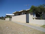
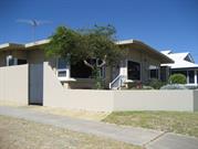
• The place has aesthetic value as a simple demonstration of the post war style expressed in brick and asbestos sheeting.
• The place has historic value for its association with the development of Safety Bay in the 1960s as a holiday destination.
Traditional holiday home of brick and fibre cement construction with shallow pitched roof. The façade is of asymmetric plan form with three large picture windows dominating the elevation. All windows to the front of the building are timber framed with a mixture of fixed and hinged panes. The main entrance to the property is via flight of steps to the front door which faces the side road. Wide eaves overhang the front elevation.
The house is predominantly of brick construction to the top of the windows with fibre cement cladding above. The window sills are canted brick, rendered and painted.
The garden is enclosed by a low masonry wall to the main Safety Bay Road frontage and high rendered masonry wall along the Waimea Road boundary.
Following World War Two Rockingham continued to develop as a popular tourist destination with the suburbs of Rockingham, Palm Beach and Safety Bay being well patronized by holidaymakers. The popular beaches not only attracted more visitors but workers, settled in the area with their families as industrial sites began to be established in the region.
This portion of Safety Bay was subdivided for residential settlement in 1935 but development was slow and many of the buildings constructed were simple shacks for holiday homes.
This residence was built c1960 as it was not evident in the 1953 aerial photograph of the site but has been built by 1965. It has not been established who was the original owner or occupant of this residence.
Aerial photographs indicate that the residence has not been significantly altered since the mid-20th century although other structures have been built at the rear of the lot facing Waimea Road.
Integrity: High
Authenticity: Moderate
Good
Individual Building or Group
| Epoch | General | Specific |
|---|---|---|
| Original Use | RESIDENTIAL | Single storey residence |
| Present Use | RESIDENTIAL | Single storey residence |
This information is provided voluntarily as a public service. The information provided is made available in good faith and is derived from sources believed to be reliable and accurate. However, the information is provided solely on the basis that readers will be responsible for making their own assessment of the matters discussed herein and are advised to verify all relevant representations, statements and information.