Local Government
Canning
Region
Metropolitan
1 Woodloes St Cannington
Lot 101 and 102 on Plan 302456
Canning
Metropolitan
Constructed from 1900
| Type | Status | Date | Documents | More information |
|---|---|---|---|---|
| Heritage List | Adopted | 18 Sep 2018 |
| Type | Status | Date | Documents |
|---|---|---|---|
| RHP - Does not warrant assessment | Current | 10 Feb 2023 |
| Type | Status | Date | Grading/Management | More information | |
|---|---|---|---|---|---|
| Category | Description | ||||
| Municipal Inventory | Adopted | 08 Aug 1995 | 3 |
3 |
|
| Municipal Inventory | Adopted | 17 Oct 2017 | 3 |
3 |
|
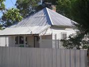
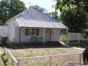
The single storey timber and iron building has cultural heritage significance for the following reasons:
The place is a modest example of a weatherboard and iron Federation residence, it is one of only a few early residences left in the area which provide the district with a sense of history and a link to its past.
The place is associated with the early development of the area, which for many years was used for agriculture, and is one of the few places pre-dating suburban development still left in the area.
As a weatherboard structure, the place has some rarity value as it represents a building material that is no longer widely used in the construction of buildings in Perth.
The place is representative of the timber building stock that was common to the Canning locality during its development in the early twentieth century. It is also representative of a simple vernacular building style associated with rural towns and their early settlement.
The subject place is located along the western side of Woodloes Street and is setback approximately 7 metres from the front boundary. A low, open timber picket and rail fence delineates it from the front boundary.
The dwelling has a pyramid hip roof clad with short sheets of corrugated sheeting. A skillion verandah is supported by 4 square posts with decorative filigree brackets. The verandah floor is timber. It has a single room street frontage with a timber panel front door located towards the northern end of the façade. There is a 3-panel timber window with security grills along the southern end of the front façade. The central panel is fixed and flanked by two sash windows.
The place consists of 2 bedrooms, kitchen/dining with gas cooker, air conditioner and a lounge area. There is also a single garage.
The Canning Road District was one of the early areas to be gazetted under the Roads Boards Act in 1871. In the early days, much of the activity in the area was focused around Mason’s Landing. It was not until 1893, when the railway line came through that the town of Cannington really came into its own, and which resulted in a shift in focus away from the river.
Old plans of the area suggest the original land grant, where the subject place was situated was allocated to Alfred Waylen in 1841. The original grant comprised 578 acres, which was located on the eastern side of the river from what is now known as Nicholson Road to the timber landing (presumably Mason’s). It was known as Location 5. Subsequent ownership is noted below:
1. Mr Alfred Waylen 578 acres 1841-1868
2. Mr Benjamin Mason 578 acres 1868-1871
3. Mr Francis Bird & family & Mr Henry Hetherington 578 acres 1871-1882
4. Mr Joseph Shaw 578 acres 1882-1886
5. Mr William E Marmion & Mr Robert Sholl 542 acres 1886-1896
The Estate was subdivided by Alfred Edward Morgans and Frank Wilson in 1900 following the death of Mr William E Marmion. It was 18 acres less than the original land grant as some land had been taken for the South West Railway, Albany Road and the Tramway and Road from Bickley Valley to Canning Landing.
A Certificate of Title was issues for Lots 43, 44 and 45 in May 1901, which covered all the land comprising what is known today as Nos. 1 and 3 Woodloes Street. The Title was issued to George Fairbrother. Twenty-one years later in 1922, the land was transferred to Christianna Broadbent. In 1927 this landholding was subdivided to form two separate land parcels, which are today known as Nos. 1 and 3 Woodloes Street. The title for No. 3 Woodloes Street was issued to Building Inspector Cecil Leslie Thorpe at this time. Christianna Broadbent maintained ownership of the subject place at No. 1 Woodloes Street.
Cecil Leslie Thorpe married Mrs Broadbent’s youngest daughter Grace in 1928. It is likely Mrs Boardbent subdivided her landholding to enable the young couple to build a house and live close by in Cannington.
Ownership of No. 1 Woodloes Street changed on numerous occasions as noted below:
1. Thomas Clifton Transport Driver 1950
2. Desmond O’Day & Dorothy McDonough Hair dresser 1955
3. Desmond O’Day & Margaret Clarke - 2003
4. Sherryl Brown & Alexander Brown 2004
Integrity and Authenticity - both High
Good
| Ref ID No | Ref Name | Ref Source | Ref Date |
|---|---|---|---|
| Woodloes Homestead Conservation Plan | Conservation Plan | March 2015 | |
| Sunday Times | Newspaper | 24 June 1928 |
Weatherboard
Masons Landing
Individual Building or Group
| Epoch | General | Specific |
|---|---|---|
| Present Use | RESIDENTIAL | Single storey residence |
| Original Use | RESIDENTIAL | Single storey residence |
| Type | General | Specific |
|---|---|---|
| Roof | METAL | Corrugated Iron |
| Wall | TIMBER | Other Timber |
| General | Specific |
|---|---|
| DEMOGRAPHIC SETTLEMENT & MOBILITY | Settlements |
This information is provided voluntarily as a public service. The information provided is made available in good faith and is derived from sources believed to be reliable and accurate. However, the information is provided solely on the basis that readers will be responsible for making their own assessment of the matters discussed herein and are advised to verify all relevant representations, statements and information.