Local Government
Claremont
Region
Metropolitan
20 Agett Rd Claremont
Lot 42 Agett Rd
Claremont
Metropolitan
Constructed from 1905
| Type | Status | Date | Documents | More information |
|---|---|---|---|---|
| Heritage List | Adopted | 07 Jul 2015 |
| Type | Status | Date | Documents |
|---|---|---|---|
| (no listings) |
| Type | Status | Date | Grading/Management | More information | |
|---|---|---|---|---|---|
| Category | Description | ||||
| Municipal Inventory | Adopted | 05 Aug 2014 | HA - Category 2 |
HA - Category 2 |
|
| Municipal Inventory | Adopted | 01 Nov 2008 |
|
Heritage Council | |
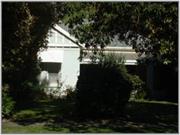
Single storey with extensive two-storey addition at the rear and double garage at the front. Rendered and painted brick walls. Hipped Colorbond roof with half-timbered gable to front and separate skillion verandah
The southern side of Agett Road was part of Swan Location 642 which was surveyed into building lots shortly after 1891 by Edward Stammers Mansfield. When the Claremont Rate Books commence in 1903 there were already five houses in Agett Road. This number increased to 17 by 1909 and 20 at the outbreak of World War I. This means that the majority of the original development of Agett Road occurred during the ‘Consolidation’ period.
The ‘Consolidation’ period was a period of rapid growth within the Town. Population and housing grew steadily with 701 households and businesses in 1905, 872 in 1910 and 1,240 in 1915. The largest area containing houses of this period is the area bounded by Mary, Gugeri, Melville and Loch Streets and Stirling Highway. Surviving heritage homes from this period indicate that housing types were mainly Federation and Federation Queen Anne with three to five rooms.
| Ref ID No | Ref Name | Ref Source | Ref Date |
|---|---|---|---|
| Town of Claremont Thematic History |
Owner Henry Hartung was a surveyor
Individual Building or Group
| Epoch | General | Specific |
|---|---|---|
| Present Use | RESIDENTIAL | Single storey residence |
| Style |
|---|
| Federation Bungalow |
| Type | General | Specific |
|---|---|---|
| Wall | BRICK | Rendered Brick |
This information is provided voluntarily as a public service. The information provided is made available in good faith and is derived from sources believed to be reliable and accurate. However, the information is provided solely on the basis that readers will be responsible for making their own assessment of the matters discussed herein and are advised to verify all relevant representations, statements and information.