
Local Government
Rockingham
Region
Metropolitan
Safety Bay Rd Safety Bay
Nearest cross street Arcadia Drive
Rockingham
Metropolitan
Constructed from 1947
| Type | Status | Date | Documents | More information |
|---|---|---|---|---|
| (no listings) |
| Type | Status | Date | Documents |
|---|---|---|---|
| (no listings) |
| Type | Status | Date | Grading/Management | More information | |
|---|---|---|---|---|---|
| Category | Description | ||||
| Municipal Inventory | Adopted | 24 Apr 2018 | Category E |
Category E |
|
The site has social value for the members of the community who have attended functions and activities at the club since 1947.
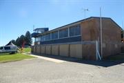
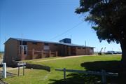
Single storey to Safety Bay Road and double storey to the beach to provide for boat access. The Yacht Club is of brick construction with shallow pitched gable roof clad in colorbond. A steel frame and colorbond observation tower is located at the south west corner of the roof. Whilst the street facing façade is quite blank in its presentation incorporating timber and glazed doors and a number of high level windows, the southern ocean facing elevation is activated demonstrating the use of the building with roller shutter doors along the ground level and expansive windows across the upper level. The current Yacht Club is not the original building but continues the use of the site.
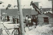
The Safety Bay Yacht Club has been operating from this site since 1947. The club rooms were originally with a Nissan Hut built closer to the water’s edge which regularly flooded. The Safety Bay School used these premises as a class room when the numbers of students increased in the post war period. The Safety Bay School was completed in 1954 and students no longer needed to use the Safety Bay Yacht Club rooms.
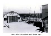
Fundraising from the community led to the construction of the current clubrooms in the early 1960s on a peppercorn agreement with the former Shire of Rockingham. Since that time the building has been used for the Yacht Club functions and a variety of community events and regular activities.
The Safety Bay Yacht Club has hosted Regattas and State Titles with in excess of 120 boats on the water at any given time.
Since establishment of the club water levels have shifted dramatically. From a deep channel between the mainland and a manufactured island (now known as Tern Island), the land has now merged and an inlet formed on the southern side which is now used for kite and wind surfing beginners.
In the 1970s the waterline was within metres of the club but has now receded some 100m offshore. The beachline continues to be a challenge getting boats in and out of the water and the club now uses a vintage Ferguson tractor for this purpose.
Integrity: High Degree
Authenticity: High Degree
Good
Individual Building or Group
| Epoch | General | Specific |
|---|---|---|
| Original Use | EDUCATIONAL | Primary School |
| Present Use | SOCIAL\RECREATIONAL | Other Sports Building |
| Present Use | Transport\Communications | Water: Other |
| Original Use | SOCIAL\RECREATIONAL | Other Sports Building |
| Original Use | Transport\Communications | Water: Other |
This information is provided voluntarily as a public service. The information provided is made available in good faith and is derived from sources believed to be reliable and accurate. However, the information is provided solely on the basis that readers will be responsible for making their own assessment of the matters discussed herein and are advised to verify all relevant representations, statements and information.