Local Government
Rockingham
Region
Metropolitan
188 Safety Bay Rd Safety Bay
Lot 10 on Plan 5948
Rockingham
Metropolitan
Constructed from 1930 to 1939
| Type | Status | Date | Documents | More information |
|---|---|---|---|---|
| Heritage List | Adopted | 24 Apr 2018 |
| Type | Status | Date | Documents |
|---|---|---|---|
| (no listings) |
| Type | Status | Date | Grading/Management | More information | |
|---|---|---|---|---|---|
| Category | Description | ||||
| Municipal Inventory | Adopted | 24 Apr 2018 | Category C |
Category C |
|
• The place has aesthetic value as a simple demonstration of the post war style expressed in timber.
• The place has historic value for its association with the development of Safety Bay in the 1940s as a holiday destination.
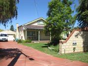
Single storey timber framed residence set back from the street amongst a garden of lawn, mature trees and low planted garden beds, behind a masonry wall.
The house is clad in a combination of weatherboard and PVC imitation weatherboard with fibre-cement cladding also used on the southern wall. The northern elevation features an external rendered brick chimney. Terracotta tiles clad the gabled roof to the main central portion of the house which extends further on the southern side and wraps around the east and west facades to create a hipped roof and front verandah. The verandah is supported on simple square timber posts and is raised a single step from ground level. The front entrance with its decorative metal grille is located under the verandah just off centre of the gable with two sets of three windows either side, a larger fixed pane in the centre with a smaller casement window either side. The gable above has a set of three centrally located windows that are a later alteration. The southern end of the verandah has been enclosed and features a set of two casement windows to its western elevation and a series of fixed windows along the southern wall. Window frames are a mixture of PVC and timber.
A concrete driveway extends along the north boundary of the property leading to a detached brick garage. A second driveway along the south boundary of the property leads to additional parking behind a gate alongside the house.
In the 1920s, Rockingham became a popular holiday destination due to the rapid increase in the use of motor transport that made the place more accessible from the Perth metropolitan area for day-trippers and holidaymakers. There were new shops, tearooms, and recreational facilities were developed to accommodate the needs of the tourists. Small holiday cottages were built along and close to the seafront. The cottages were small with one or two bedrooms and a kitchen with a verandah. Despite being uncomfortable and not well furnished, the cottages were cooler than tents and were the preferred choice of accommodation for tourists at that time.
In the 1930s, as access to Safety Bay was improved, the population grew and houses were built on Safety Bay Road and both sides of Penguin Road. There were also houses built facing Shoalwater Bay. The houses are generally larger than the earlier cottages and were timber-framed with galvanised iron or tiled roofs. Internally, they had two to four rooms and were surrounded by enclosed verandahs, which accommodated extra sleeping and living space, and protection from the prevailing winds.
The lack of a good road to Safety Bay was an impediment to development and it was not until 1939 that a new road was cleared and laid to Safety Bay. Much of the land in the Safety Bay area was owned by Alfred John Henry Watts who was a resident and land agent in the area from c1933.
A subdivision plan for this portion of Safety Bay was approved by the Department of Lands and Surveys in 1940. The style of this residence is consistent with a construction date in the early 1940s. The original owner or occupiers of this property have not been determined.
Aerial photographs indicate the form and extent of the original residence can still be readily determined with the only apparent addition across the rear of the building in the early 2000s. Other structures have been built in the rear of the lot since the mid 20th century.
Integrity: High
Authenticity: High
Good
Individual Building or Group
| Epoch | General | Specific |
|---|---|---|
| Present Use | RESIDENTIAL | Single storey residence |
| Original Use | RESIDENTIAL | Single storey residence |
This information is provided voluntarily as a public service. The information provided is made available in good faith and is derived from sources believed to be reliable and accurate. However, the information is provided solely on the basis that readers will be responsible for making their own assessment of the matters discussed herein and are advised to verify all relevant representations, statements and information.