Local Government
Cambridge
Region
Metropolitan
Templetonia Cr City Beach
Bound by Dampier Avenue, Templetonia Crescent, The Boulevard, Lowanna Way and West Coast Highway
Bush Forever Site 310
Cambridge
Metropolitan
| Type | Status | Date | Documents | More information |
|---|---|---|---|---|
| (no listings) |
| Type | Status | Date | Documents |
|---|---|---|---|
| (no listings) |
| Type | Status | Date | Grading/Management | More information | |
|---|---|---|---|---|---|
| Category | Description | ||||
| Municipal Inventory | Adopted | 27 Nov 2018 | Category 4 |
Category 4 |
|
The place has aesthetic value as an area of largely indigenous plant species that accessible to the community which is consistent with the
landscapes in adjacent public spaces.
The place has historic value for its association with the development of City Beach in the 1960s and demonstrates the earlier path of The
Boulevard.
The place has social value as a locality of passive recreation for the community.
The place has potential research value as study of its regenerated native species, as a Bush Forever Site may provide guidance for other cleared localities in a harsh environment.
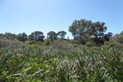
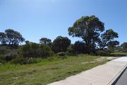
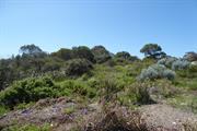
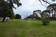
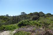
Templetonia Park is a park predominantly of bushland bound by The Boulevard, West Coast Highway, Lowanna Way, Dampier Avenue and Templetonia Crescent.
The park is mainly open grass interspersed with a few mature trees and native bushland. A small children’s play area is located towards the western boundary of the site. The park extends along The Boulevard westwards to West Coast Highway and forms part of the green edge to the highway.
This portion of City Beach was largely developed in the 1960s. As part of the development the alignment of The Boulevard was changed to create a straight line to the coast. The former alignment of The Boulevard forms one of the tracks through the park.
At the time of the residential subdivisions nearby in the mid 1960s, aerial photographs show the park as a cleared sandy area. Regeneration of the park with native species has slowly occurred with little apparent intervention. The children's playground was built in the early 1990s although the grassed area had been established previously. The park is designated as a Bush Forever Site.
Integrity: High
Authenticity: High
Good
| Ref ID No | Ref Name | Ref Source | Ref Date |
|---|---|---|---|
| Aerial photographs, Landgate | Online Resources | 1953-2016 |
Urban Park
| Epoch | General | Specific |
|---|---|---|
| Original Use | PARK\RESERVE | Park\Reserve |
| Present Use | PARK\RESERVE | Park\Reserve |
| General | Specific |
|---|---|
| SOCIAL & CIVIC ACTIVITIES | Sport, recreation & entertainment |
This information is provided voluntarily as a public service. The information provided is made available in good faith and is derived from sources believed to be reliable and accurate. However, the information is provided solely on the basis that readers will be responsible for making their own assessment of the matters discussed herein and are advised to verify all relevant representations, statements and information.