Local Government
Cambridge
Region
Metropolitan
Lake Monger Dr Wembley
bound by Lake Monger Dr, Gregory St, Dodd St and Mitchell Fwy
Galup (Aboriginal name)
Cambridge
Metropolitan
| Type | Status | Date | Documents | More information |
|---|---|---|---|---|
| Heritage List | Adopted | 27 Nov 2018 |
| Type | Status | Date | Documents |
|---|---|---|---|
| RHP - To be assessed | Current | 29 Sep 2007 |
| Type | Status | Date | Grading/Management | More information | |
|---|---|---|---|---|---|
| Category | Description | ||||
| Municipal Inventory | Adopted | 17 Dec 1996 |
|
||
| Municipal Inventory | Adopted | 27 Nov 2018 | Category 1 |
Category 1 |
|
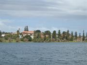
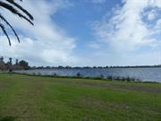
The place has aesthetic value as a large, well maintained landscape in the metropolitan area which is a landmark in the district.
The place has historic and social value for the Whadjuk Noongar peoples who used the place for food, shelter and spiritual reasons.
The place has historic value for its association with the early settlement of the district in the 1830s and particularly with the Monger family who leased this lake and its surrounds and provided the origin for the name.
The place has historic value for its association with market gardens which operated close to the city of Perth in the 19th and 20th century.
The place has historic value for its association with sports and recreation on the lake from the 19th century.
The place has ongoing social value for the members of the community who have enjoyed the lake and its surrounds for passive recreation for many decades.
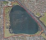
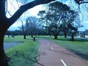
Monger Drive to the south and the Mitchell Freeway to the north east side of the lake. The Reserve totals 70 hectares which is predominantly occupied by the lake. Additional facilities include a walk trail around the lake, sporting facilities, visitor facilities and children’s play area.
The lake is surrounded by flora and fauna, with a walk through the conservation area with boardwalks and lookouts across the lake. The south foreshore and the west side of the lake provide a grassy contrast to the lake and dense plantings along the north eastern side of the lake.
The buildings within the grounds are representative of the post war period.
Prior to European settlement, the indigenous inhabitants of the south-west of Western Australia, were the Noongar, and Whadjuk is the name of the dialectal group from the Perth area. Given the abundance of wildlife and flora the lake was a hunting ground and campsite for the Whadjuk Noongar. As with most water bodies in the region the lake is associated with the Wagyl mythology. The myth describes the track of a serpent being who in his journey towards the sea, deviates from his route and emerges from the ground which gives rise to Lake Monger. The lake and a significant part of the reserve are registered with the Department of Indigenous Affairs as an Aboriginal heritage site. Previous research has indicated the area was called Keiermulu which translates to 'the home fires or camp' and the lake was Galup or Kalup.
After European settlement, it became known as either Large Lake or Triangle Lake (based on its roughly triangular shape). By 1832, the lands around the lake had been subdivided into eight lots: a southern one was acquired by John Henry Monger and described as 200 acres [81 hectares] of Perthshire Location Ae abutting Lake Monger. Monger and his family left the landholding in 1836 and settled in York.
In the latter half of the 20th century as the population increased with the arrival of convicts and later with the discoveries of gold in the colony, the land around the lake was used for market gardens. This was a common practice for the low lying swampy lands in the metropolitan region.
While the swampy lands around the lake were utilised for market gardens the body of water was regularly used for recreation. Tragically several deaths occurred in the 19th and 20th century as a result of boating or swimming accidents.
In 1902, the Leederville Council appointed a board to manage the lake. In 1908, the Waverley Boat Club was formed for sailing on the lake and in 1909, a drain was completed which connected the lake with the Swan River which allowed the water level to be managed and this drain is still [2018] in operation.
In the early years of the 20th century the lake was popular for picnics and boating. A jetty and a bandstand was located near the junction with St Leonards Avenue. This jetty was later adopted by the Rover Scouts until boating ceased in 1938.
In 1917, the lake and its surrounds were put under the administration of the City of Perth for use as a public park. Thereafter the Chinese market gardens and dairies which were operating around the lake were acquired by the City for public lands. By 1928, the gardeners were gone and by 1930, 50 hectares was under the control of the City of Perth to be developed as the Lake Monger Reserve.
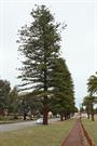
In 1932, dredging works began to reclaim land from the swamp and by June 1933. 110,000 tons (90718 tonnes) of silt had been pumped from the lake allowing 4.8 hectares of land to be reclaimed. As a reflection of the attitudes to swamp land at that time much of the fringing vegetation was removed and replaced with lawns. The southern shore of the lake was developed with a kiosk, bathing sheds, boat house and a jetty. At the completion of these works a celebration was held with a swim through, canoe race, a picnic and bonfires. The lake was used extensively for picnicking, yachting, swimming and fishing and further dredging was undertaken to enable more successful yachting. The Norfolk Island Pine Trees (Araucaria heterophylla) and Date Palms (Phoenix dactylifera which border the northern side of Lake Monger Drive are remnants from this beautification program.
Reclamation of land continued into the 1930s with dumping of rubbish and raw sewage on the north east side of the lake. Not surprisingly by 1936 the quality of the water had deteriorated and infestations of midges were recorded.
In the late 1930s, a series of drownings led to the decision to ban boating and swimming was discouraged.
In the late 1950s, the 1955 Stephenson plan guided the decision to allocate a portion of the reserve for the future Mitchell Freeway which was built in the 1970s.
During the 1960s a more widespread understanding of the environmental affect of past practices lead to the decision to build a small island in the south west corner of the lake to attract bird life back to the lake. Since then the lake and surrounding parklands have been managed more sensitively although issues of fertiliser run off from the surrounding suburbs is one of many issues which continue to be a challenge.
In 1994, Lake Monger came under the management of the Town of Cambridge. The lake is now a popular destination for passive recreation and is well known for its regular and large population of black swans which are popular with tourists.
Another popular feature of the lake are the Norfolk Island Pines aligning the northern boundary of Lake Monger Drive. For many decades, one of these large pine trees near the corner with Gregory Street is strung with lights to mark the festive season in December and January.
Integrity: High
Authenticity: High
| Ref ID No | Ref Name | Ref Source | Ref Date |
|---|---|---|---|
| The West Australian | Newspaper | 27 September 1937 | |
| Stannage, C.T. The People of Perth, Perth City Council. | Book | 1979 | |
| B Gill & B Gay;"Remembering the Days..West Leederville Primary School 1898-1988". | AG O'Keefe & Son, Subiaco | 1988 | |
| Collard, L.; Revell, G.; Palmer, D.; Leonard, L. Noongar Placenames associated with the Goordandalup (Crawley bay) area of the Gabee Derbalor Derbal Yaragan Beloo (Swan River). | Report | 1999 | |
| Aerial Photographs, Landgate | Online Reference Documents | 1953-2016 | |
| "Lake Monger Management Plan, Part I- Background, City of Perth". | City of Perth | 1992 | |
| The West Australian, p. 18. | Newspaper | 8 August 1936 |
| Library Id | Title | Medium | Year Of Publication |
|---|---|---|---|
| 11479 | Our Western Australian home: being sketches of scenery and society in the Colony | Heritage Study {Other} | 2016 |
Landscape
| Epoch | General | Specific |
|---|---|---|
| Original Use | GOVERNMENTAL | Reservoir or Dam |
| General | Specific |
|---|---|
| SOCIAL & CIVIC ACTIVITIES | Sport, recreation & entertainment |
| DEMOGRAPHIC SETTLEMENT & MOBILITY | Aboriginal Occupation |
This information is provided voluntarily as a public service. The information provided is made available in good faith and is derived from sources believed to be reliable and accurate. However, the information is provided solely on the basis that readers will be responsible for making their own assessment of the matters discussed herein and are advised to verify all relevant representations, statements and information.