Local Government
Plantagenet
Region
Great Southern
Muir Hwy Kenton
Over Kent River
MRWA Bridge 500
Plantagenet
Great Southern
| Type | Status | Date | Documents | More information |
|---|---|---|---|---|
| (no listings) |
| Type | Status | Date | Documents |
|---|---|---|---|
| RHP - Does not warrant assessment | Current | 29 Nov 2019 |
| Type | Status | Date | Grading/Management | More information | |
|---|---|---|---|---|---|
| Category | Description | ||||
| (no listings) |
|
||||
The place is demonstrates the widespread use of timber as a structural material in twentieth century bridge building;
The place is associated with the growth of regional road infrastructure in the mid twentieth century as road began to replace rail.
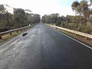
Bridge 500, Muir Highway over Kent River, Perillup is a double lane timber, concrete and steel road bridge spanning the Kent River, approximately 45km west-northwest of the town of Mount Barker. The bridge is approximately 44m long, 7.6m wide and sits approximately 1m above the creek bed at its highest point.
The bridge consists of 7 spans constructed along a west-northwest to east-southeast axis. The bridge abutments consist of dressed timber planks laid against an earth embankment, which has been further supported by timber logs planted upright against the planks. Some of these upright timber logs have since been replaced by galvanised steel members. The foundation of the abutment further appears to have been modified through the use of concrete blocks on at least one side.
In the region around Plantagenet, the Noongar groups known as the Ganeang, Goreng and Minang lived for tens of thousands of years, moving between the coast and inland forests to utilise the natural resources of the area.
This way of life began to be disrupted after 1829 with the arrival of colonists, with farmers moving into the Plantagenet area after 1840. A small network of farms and orchards slowly developed over the next few decades, however this growth accelerated after 1890 with the arrival of railway transport and the increased demand for produce arising from the Gold Boom. By the Turn of the century, Plantagenet was a modestly sized but thriving mixed agricultural area.
Other Built Type
| Epoch | General | Specific |
|---|---|---|
| Original Use | Transport\Communications | Road: Bridge |
This information is provided voluntarily as a public service. The information provided is made available in good faith and is derived from sources believed to be reliable and accurate. However, the information is provided solely on the basis that readers will be responsible for making their own assessment of the matters discussed herein and are advised to verify all relevant representations, statements and information.