Local Government
Canning
Region
Metropolitan
Canning River Wilson & Ferndale
30/3/2011 Other address details: Lots 24 & 25 Queens Park Rd, Wilson; Lot 8 Ferndale Cres, Ferndale. VFL. Mid point between Nicholson Road bridge and Riverton Bridge on Canning River within Canning River Regional Park. ; Lot 4162 on Plan 93607
Canning
Metropolitan
Constructed from 1926, Constructed from 1989, Constructed from 2017
| Type | Status | Date | Documents | More information |
|---|---|---|---|---|
| Heritage List | Adopted | 18 Sep 2018 | ||
| State Register | Registered | 21 Dec 2012 |
Register Entry Assessment Documentation |
Heritage Council |
| Type | Status | Date | Documents |
|---|---|---|---|
| (no listings) |
| Type | Status | Date | Grading/Management | More information | |
|---|---|---|---|---|---|
| Category | Description | ||||
| Classified by the National Trust | Classified | 14 Apr 1998 |
|
Heritage Council | |
| Municipal Inventory | Adopted | 17 Oct 2017 | 1 |
1 |
|
| Municipal Inventory | Adopted | 08 Aug 1995 | 1 |
1 |
|
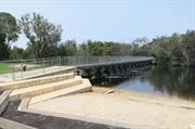
Kent Street Weir, a steel and concrete weir fitted with floodgates, and a steel bridge structure that spans the Canning River, has cultural heritage significance for the following reasons:
- the place is related to the development of agricultural practice in Western Australia, in particular the Canning River area, in relation to a major scheme to provide irrigation services and water to that region;
- the place is valued by the community as a well-known landmark in the Canning River Regional Park;
- the place was originally constructed to prevent the ingress of salt water upstream during the summer months when the lower reaches of the river became saline due to tidal movements, and was an unique early technological achievement in the Perth Metropolitan; and,
- the place provided deep water pools for swimming and fishing, and until the 1960s was virtually the only public swimming facility in the district.
Kent Street Weir is a weir and bridge structure spanning across the Canning River. The Weir is surrounded by parklands, playing fields and natural bush at the end of Kent Street, in the Canning River Regional Park, Wilson
The Kent Street Weir was upgraded in 1989, and comprised 17 concrete bays, each containing four removable stop boards which cause fresh water to pool upstream of the weir. These boards are typically removed once there has been enough rainfall to push salt water downstream past the weir (usually in May/June), and replaced when river flows are too low to stop salt water moving back upstream (usually October/November). This annual cycle of stop board removal and replacement allows annual flushing of the system, and facilitated the movement of fish and other animals upstream of the weir during winter months.
During 2017 Kent Street Weir underwent refurbishment by the Department of Water and Environment Regulation who at this period in time manage the asset. The upgrade incorporates hydraulically operated lay-flat gates removing the manually adjusted weir boards. Incorporation of a fishway facilitates the movement of fish through the weir, and a new improved footbridge is included. On completion the asset (weir, fishway and bridge) will be handed over to the Department of Biodiversity, Conservation and Attractions for ongoing management.
The construction of the weir resulted in important environmental changes, with salt tolerant riverine species confined to the downstream side of the weir and only freshwater species on the upstream side.
The weir is located at a scenic stretch of the river with natural vegetaion predominating along the banks. The former cleared open rural landscape which adjoins on either side now forms part of the public open space system of the regional park.
The first ever ‘Kent Street Weir’ was constructed from sand bags at this site in 1911, and aimed to stop salt water from affecting agricultural land upstream. A more permanent weir was not completed until 1927 and has since undergone numerous changes to its design and function.
The 1927 structure was designed by the Public Works Engineer, at the request of local residents to stop the ingress of salt water during the summer months. Although it was called a ‘weir’ it actually functioned as a floodgate as the timber boards would be removed prior to the arrival of the winter rains to prevent the surrounding land flooding. The boards would then be reinserted in summer.
The weir also became a focus for recreational activity on the river in the inter-war years, providing deep water pools for swimming and good fishing spots. By the early 1960s other previously popular swimming places in the river had deteriorated, and the pool at the weir became one of only a few public swimming facility in the district.
By October 1932, the weir’s performance was not satisfactory. Salt water was getting above the weir at certain times of the year. A new weir was completed by 20 June 1940 and provided a much more substantial and efficient lock. By the summer of 1960/61, Kent Street Weir was showing signs of failure and works to remedy the situation were completed the following year. The weir was further upgraded in 1989, which included a timber bridge allowing access to both sides of the river and linking with the cycleway system through the regional park. A new weir was constructed in 2017
Intactness of fabric: 1960's concrete structure probably remains intact; the original timber boardwalk and minimal handrail was replaced by the 1989 bridge and balustrade construction and totally replaced by the 2017 structure.
Alterations: Concrete structure upgraded; addition of timber bridge superstructure.
Good: well maintained
| Ref ID No | Ref Name | Ref Source | Ref Date |
|---|---|---|---|
| Richards; "Canning River Regional Park, Western Australia: Historical Survey". pp 61, 73, 74 & 70 | DPUD | 1991 | |
| Municipal Heritage Inventory | City of Canning | 2017 |
Swimming
Canning River Regional Park
| Library Id | Title | Medium | Year Of Publication |
|---|---|---|---|
| 9766 | Report for Kent St Weir assessment. | Electronic | 2009 |
Other Built Type
| Epoch | General | Specific |
|---|---|---|
| Original Use | GOVERNMENTAL | Other |
| Original Use | GOVERNMENTAL | Reservoir or Dam |
| Present Use | SOCIAL\RECREATIONAL | Other |
| Style |
|---|
| Other Style |
| Type | General | Specific |
|---|---|---|
| Wall | CONCRETE | Reinforced Concrete |
| General | Specific |
|---|---|
| OUTSIDE INFLUENCES | World Wars & other wars |
| SOCIAL & CIVIC ACTIVITIES | Sport, recreation & entertainment |
| OCCUPATIONS | Rural industry & market gardening |
This information is provided voluntarily as a public service. The information provided is made available in good faith and is derived from sources believed to be reliable and accurate. However, the information is provided solely on the basis that readers will be responsible for making their own assessment of the matters discussed herein and are advised to verify all relevant representations, statements and information.