Local Government
Canning
Region
Metropolitan
Woodloes St; Fern Rd; Adenia Rd; Riverton Drive; Rssmyn Shelley Rivtn Ferndale Cngtn Wilson
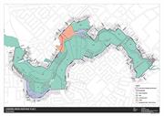
All landholdings and portions thereof that fall within the Canning River Heritage Place Map (included in this Place Record Form). This includes multiple lots and reserves in the ownership of the City of Canning and the Crown between the Shelley Bridge and the Nicholson Road Bridge, and portions within Nos. 1, 3 and 35 Woodloes Street, Cannington, No. 4 Fern Road, Shelley, No. 14 Castledare Place, Wilson, to the extent indicated on the heritage place map.
Canning River
Djarlgarra Beelier (place of abundance)
Dyarlgaard (Noongar country)
Canning
Metropolitan
| Type | Status | Date | Documents | More information |
|---|---|---|---|---|
| Heritage List | Adopted | 18 Sep 2018 |
| Type | Status | Date | Documents |
|---|---|---|---|
| (no listings) |
| Type | Status | Date | Grading/Management | More information | |
|---|---|---|---|---|---|
| Category | Description | ||||
| Municipal Inventory | Adopted | 17 Oct 2017 | 1 |
1 |
|
Canning River Regional Park has cultural, history and aesthetic heritage significance for the following reasons:
The place was used by Aboriginal families for camping, hunting, fishing and as a place for gathering.
The place is associated with early European navigation in the area.
The place has strong connection to early colonial timber industry, most notably the operation of Mason and Bird.
The river continues to be used as a place for community recreation including swimming, fishing, boating and has been an important element in the social fabric of the district.
The ecosystem surrounding the Canning River has ability to provide information on native Western Australian flora and fauna.
The early use of the river for transportation, including transport associated with the operations of the timber felling industry, has ability to yield substantial archaeological evidence.
The place provides a demarcation between fresh and salt water environments in the same river system, it provides avenues for research into requirements and adaptation of river species.
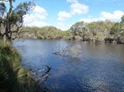
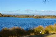
The Canning River Regional Park (CRRP) covers an area of approximately 266 hectares between the Canning River from Nicholson Road Bridge in Cannington to the Shelley Bridge in Rossmoyne. CRRP extends for approximately six kilometres and consists of large areas of parkland for public recreation and extensive wetlands which are reserved for the conservation of flora and fauna.
The CRRP runs between two neighbouring areas of the Beeliar and Beeloo Noogars. The river is a rich source of fish, eggs, gilgies, tortoises and plant life within the river as well as its surrounding wetlands.
The river contains both salt water and fresh water, and is separated by Kent Street Weir, which contains boards to stop the movement of fish and water from moving upstream.
The place contains places considered to be of cultural heritage including The Islands, Masons Landing/Timber Station (1862-1882), Firewood Landing (1880), Sandbag Weir (1911), Firewood landing (1880s), Central Canning Bridge/Nicholson Road Bridge (1885), First Rapid, Brickworks landing (1890’s), Rileys Market Garden (1890-1940), Brickworks (1896), First Riverton Bridge (1910- 1911), Clay Pits, Wharf Street Bathing Ground, Kent Street Weir (1927), Wilson Park/Yankee Yards (1930s), Sikh Cemetery (1932), Second Riverton Bridge (1954), Mounsey’s Footbridge (1960s), Greenfield Street Footbridge (1964), Short Street Bathing Ground.
Prior to colonial settlement, Djarlgarra Beelier (later named Canning River) was used by Aboriginal families for camping, hunting, fishing and as a place for gathering.
In 1801, the mouth of the river was discovered by a French exploring party and named Entrée Moreau after Charles Moreau, a midshipman with the party.
In March 1827, the river later received its contemporary name by Captain James Stirling, following an examination of the region. The river was named after George Canning (1770-1827), an important British statesman who was Prime Minister of Great Britain at that time. The majority of land along the Canning River was set aside for public use when reserved for landing places were created.
The Canning River became an important navigational route during early exploration of the Swan River Colony. Later, the river facilitated the timber industry by connecting the Darling Ranges to Mason’s Landing.
Mason’s Landing was established by Benjamin Mason and Francis Bird in 1862. Timber was originally cut and loaded at the river on River Street and taken to its barge further downstream to Fremantle.
Other landing places, such as the Brickworks in Riverton in 1896, were established along the river wherever suitable conditions existed which became a community facility for both economical and leisure purposes.
The introduction of rail and improved roads later made transport along the river uneconomical due to the time taken to load and unload barges, sometimes having to bypass sections of the river and to the fact that the distance between Cannington and Perth was doubled. The many sand and rock bars also made the river unsuitable for transportation (apart from flat-bottomed boats or barges) and the dredge ‘Black Swan’ was used to prepare channels and keep them clear for barges and steamers.
The Canning River became the life and blood of settlers for orchards and industries. In 1911, a weir was constructed near Kent Street out of sand bags to stop salt water from affecting agricultural land upstream.
The weir also became a focus for recreational activity on the river in the inter-war years, providing deep water pools for swimming and good fishing spots. Unfortunately for the Canning River, the opening of the Canning Dam in 1933 reduced the flow therefore changed the character of the river.
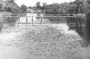
The Mounsey family had a dairy farm opposite Mason Street which went back to Menzies Street. Mr. Mounsey built a 44 gallon drum pontoon with an overhead wire for people to use during times of the year when the river flooded. Mr. Mounsey later built a rickety bridge referred to as Mounsey’s Bridge. Mounsey’s Bridge no longer exists and pedestrian access across this section of the river is maintained by a concrete footbridge that was built in 1964.
By the 1960s other previously popular swimming places in the river had deteriorated, and the pool at the weir had become virtually the only public swimming facility in the district.
In the 1970s, a reclamation scheme was implemented by the Canning Shire, particularly around the Shelley area. Throughout this time, there was also a significant growth of unknown weed clogging in the freshwater reaches above Kent Street Weir. This growth was suspected to be caused from fish tanks being emptied into drains reaching the river, and nutrients leaching into the river from fertilisers used on home gardens.
Whilst many of its original uses such as transportation and swimming are lost, the Canning River today remains as a place for predominantly boating, kayaking and fishing.
Historic Values:
The place has historically been used by the local Noongar population for hunting, fishing and seasonal settlement.
The place represents the use of the River by early Europeans for exploration and navigation of the district.
The place has a strong association with the European settlement in the area particularly connected to the timber industry and recreation.
Integrity - High
Authenticity - Moderate
Good
| Ref ID No | Ref Name | Ref Source | Ref Date |
|---|---|---|---|
| F Carden | Along The Canning | 1991 | |
| O Richards | Canning River Regional park: Historical Survey | 1991 | |
| A Buchanan / R Dalais | Canning River Stories | 2012 |
Mason
Bird
Djarlgarra Beelier
Mounsey
Riley
Large Conservation Region
| Epoch | General | Specific |
|---|---|---|
| Present Use | PARK\RESERVE | Park\Reserve |
| General | Specific |
|---|---|
| DEMOGRAPHIC SETTLEMENT & MOBILITY | Settlements |
This information is provided voluntarily as a public service. The information provided is made available in good faith and is derived from sources believed to be reliable and accurate. However, the information is provided solely on the basis that readers will be responsible for making their own assessment of the matters discussed herein and are advised to verify all relevant representations, statements and information.