Local Government
Katanning
Region
Great Southern
Kojonup-Pingrup Katanning
Katanning
Great Southern
Constructed from 1937, Constructed from 1991
| Type | Status | Date | Documents | More information |
|---|---|---|---|---|
| (no listings) |
| Type | Status | Date | Documents |
|---|---|---|---|
| RHP - Does not warrant assessment | Current | 18 May 2022 |
| Type | Status | Date | Grading/Management | More information | |
|---|---|---|---|---|---|
| Category | Description | ||||
| (no listings) |
|
||||
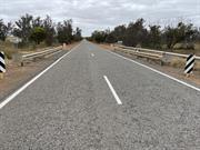
• The place is a modest example of a timber road bridge constructed using sustenance labour, which also demonstrates an innovative technique used during this era.
• The place has some historic value for its associations with the commencement of bulk grain handling in the Great Southern.
Bridge 0627 is a two span timber bridge at 4.6m long and spanning 3.66m, located over Dort Creek, Katanning. The bridge is consturcted from timber with a bitumen seal. In 1991, a concrete overlay was applied to the service.
Wagyl Kaip and the Southern Noongar region refers to the Ganeang, Goreng and Minang language groups. The region includes the towns of Boyup Brook, Walpole, Denmark, Mt Barker, Cranbrook, Broomehill, Tambellup, Katanning, and Albany. The area is contains a number of significant Aboriginal sites including the Stirling Ranges. The Southern Noongar lived a hunter-gatherer lifestyle across the region until the British arrived in the 1820s-30s. Noongar people were displaced from their traditional lands and conflict continued throughout the nineteenth-century.
The Great Southern Region extends from the Shires of Woodanilling and Kojonup in the northwest to Ravensthorpe in the east, and extends along the south coast from Nornalup Inlet to Oldfield River Estuary. More than half the population of the region live in greater Albany, with Katanning, Denmark and Mount Barker also having relatively large populations. Albany is a significant regional centre and serves as one of the State’s major ports. Land use across the region is mixed use farming, largely wheat and sheep, though other crops and industries are also important including barley and canola, manufacturing, vineyards, tourism, mining and timber.
Other Built Type
| Type | General | Specific |
|---|---|---|
| Other | TIMBER | Other Timber |
This information is provided voluntarily as a public service. The information provided is made available in good faith and is derived from sources believed to be reliable and accurate. However, the information is provided solely on the basis that readers will be responsible for making their own assessment of the matters discussed herein and are advised to verify all relevant representations, statements and information.