Local Government
Dundas
Region
Goldfields
59 Goodliffe St Norseman
Dundas
Goldfields
| Type | Status | Date | Documents | More information |
|---|---|---|---|---|
| (no listings) |
| Type | Status | Date | Documents |
|---|---|---|---|
| RHP - Does not warrant assessment | Current | 11 Jun 2020 |
| Type | Status | Date | Grading/Management | More information | |
|---|---|---|---|---|---|
| Category | Description | ||||
| (no listings) |
|
||||
• The place demonstrates the pattern of historic settlement in the local area; and,
• The place demonstrates the provision of government services in the post-WWII period.
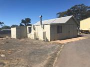
Watercorp Depot, Norseman lies within a mixed residential/light industrial landscape in the Goldfields town of Norseman, part of a larger fenced block containing a number of Watercorp storage facilities.
The place consists of a single storey steel frame shed clad in corrugated iron, oriented north-south, adjacent to a newer storage shed oriented east-west. This physical description relates to the original north-south oriented shed.
The overall form of the building consists of a single central storage space, a smaller western extension as a living space, with another smaller lean-to constructed along the western edge of the secondary area.
The frame of the building consists of tubular metal, topped with steel “I” beams, supporting tubular metal roof frames which in turn support timber roof purlins. The wall frame consists of horizontal timber members to which the cladding is attached; the connection between the timber and metal frames is not apparent.
The Norseman region are the traditional lands of the Ngadju people, small groups of extended families who lived in the area for tens of thousands of years. This way of life began to be disturbed after 1840 with the arrival of Colonial explorers looking for pastoral land for settlement. After the establishment of Port Eucla to the south, Colonial settlers began to move into the area in the 1870s. The area remained sparsely populated until the 1890s with the discovery of gold in the region by William Moir. A substantial gold field was discovered in the area by Laurie Sinclair in 1894, named “Norseman” after his horse. A small gold mining town sprung up in this location by 1896 and the area was proclaimed a municipality.
A map of the new settlement in 1897 shows the town had been arranged on a typical grid system, with various reserved for public purposes. On lots 124 and 125, Reserve 3324, a pencil notation describing the area as “Public Utility.” This notation was formalised in the 1906 map of Norseman.
Individual Building or Group
| Type | General | Specific |
|---|---|---|
| Other | ASBESTOS | Other Asbestos |
| Other | TIMBER | Other Timber |
| Roof | METAL | Tin |
This information is provided voluntarily as a public service. The information provided is made available in good faith and is derived from sources believed to be reliable and accurate. However, the information is provided solely on the basis that readers will be responsible for making their own assessment of the matters discussed herein and are advised to verify all relevant representations, statements and information.