Local Government
Gosnells
Region
Metropolitan
End of Harris St Beckenham
Canning River
Yules Rapids Ford
Gosnells
Metropolitan
| Type | Status | Date | Documents | More information |
|---|---|---|---|---|
| (no listings) |
| Type | Status | Date | Documents |
|---|---|---|---|
| (no listings) |
| Type | Status | Date | Grading/Management | More information | |
|---|---|---|---|---|---|
| Category | Description | ||||
| Municipal Inventory | Adopted | 13 Sep 2016 | Category 3 |
Category 3 |
|
This site has historic value for its association with the methods of transport during and before European settlement of the district.
The place has aesthetic value for its grouping of plantings surrounding the water course in an undulating landscape.
The site has historic value for its association with the early landowner Thomas Newte Yule.
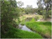
Area of natural environment amidst residential development. Narrow creek passing through the area and under Kenwick Link out towards the Canning River.
This section of the Canning River was used as a crossing by the Aboriginal inhabitants prior to European settlement of the district. The first settlers used the location in the same way and it was known as 'The Rapids'. The adjacent landholding, portion of location 8 and 9, was granted to three offices of the East India Company; Thomas Newte Yule, Lieutenant Ninian Lowis and Captain Richmond Houghton. They developed the land as a market garden and farming property. The name 'Yule's Rapids' appears to have been in common usage by 1834.
Yule's Rapids was a logical destination for ferries and water craft as it was difficult to pass beyond this point until the water flow was controlled with weirs.
The site is currently [2016] adjacent to the SERCUL South East Regional Centre of Urban Landcare headquarters (see place B10). The grounds adjacent to the site are well maintained.
Good
| Ref ID No | Ref Name | Ref Source | Ref Date |
|---|---|---|---|
| The Gosnells Story, McDonald & Cooper | 1988 | ||
| The Perth Gazette and Western Australian Journal | 1834 | ||
| Precinct 18 Canning River, Swan River Trust Fact Sheets, Precinct 18 Canning River - Nicholson Road Bridge to Southern River Confluence |
Landscape
| Epoch | General | Specific |
|---|---|---|
| Original Use | OTHER | Other |
| Present Use | Transport\Communications | Water: Other |
| General | Specific |
|---|---|
| TRANSPORT & COMMUNICATIONS | Road transport |
| PEOPLE | Early settlers |
This information is provided voluntarily as a public service. The information provided is made available in good faith and is derived from sources believed to be reliable and accurate. However, the information is provided solely on the basis that readers will be responsible for making their own assessment of the matters discussed herein and are advised to verify all relevant representations, statements and information.