Local Government
Melville
Region
Metropolitan
Canning Hwy Ardross
Bounded clockwise by Cunningham & Hickey Sts, McCallum Cres, Davy St, Barnard St & Canning Hwy
Melville
Metropolitan
Constructed from 1912
| Type | Status | Date | Documents | More information |
|---|---|---|---|---|
| Heritage List | Adopted | 16 Jun 2020 | ||
| State Register | Registered | 02 Sep 1997 |
Register Entry Assessment Documentation |
Heritage Council |
| Type | Status | Date | Documents |
|---|---|---|---|
| (no listings) |
| Type | Status | Date | Grading/Management | More information | |
|---|---|---|---|---|---|
| Category | Description | ||||
| Art Deco Significant Bldg Survey | Completed | 30 Jun 1994 |
|
Heritage Council | |
| Register of the National Estate | Indicative Place |
|
Heritage Council | ||
| Municipal Inventory | Adopted | 17 Jun 2014 | Category A |
Category A |
|
The Wireless Hill Reserve is significant on the following grounds:
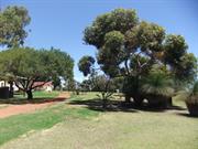
Aesthetic Value: The reserve is the only remaining large area of natural bushland close to the south side of the river.
Historic Value: The buildings in the reserve are all linked to the operation of the now defunct Wireless Station.
Social value: The reserve enhances the quality of life for the residents of Melville and it's visitors.
Rarity Value: The reserve is the only remaining large area of natural bushland close to the south side of the river.
Wireless Hill Park, comprising brick and tile radio operations buildings, brick and tile staff accommodation buildings, concrete tower bases, culturally modified landscape settings and urban bushland, has cultural heritage significance for the following reasons:
Radio telecommunications provided one of the important links between Australia and the rest of the world at a time when these links were significant to a relatively small community in one of the most remote cities in the world; the radio communications station has played a part in the development of commercial radio broadcasting and experimental shortwave radio as well as functioning as a communications vehicle for state government instrumentalities and marine safety; it once contained all the elements of a working radio communications station from the nascent development to eventual phasing out; the place retains sufficient 1912 fabric to remain a fine example of an early radio communications station; the place was one of five main radio telecommunication stations in Australia participating in international, national, State-wide and regional radio communications and broadcasting; the mast is remembered as a highly visible and prominent landmark both by day and with its lighting at night, until decommissioned; today, the park forms the basis of a highly valued area of urban bushland.
The reserve consists of a large tract of native bushland, the original wireless station buildings remain and a network of walking paths have been established.
Wireless Hill Park comprises a 41 hectare site as a landmark site of high ground, predominantly natural Banksia and jarrah woodland, with the former Wire Station Operations buildings and structures extant on the high ground of the site, including a macadamised roadway connecting the Station to four former staff houses on the low side of the site at the northwest side.
The original 112 metre tall mast and guys have been removed. The anchor blocks at the base of the mast and the three anchor blocks for the guys survive, two converted to viewing platforms.
Mature introduced landscape and grassed areas, car parking, access roadway and public amenities have been introduced in the vicinity of the former Station, now converted for use as a Museum of Telecommunications and associated community
facilities.
Interpretive material relating to the flora and fauna of the natural bushland and of the former use of the place as a Telecommunications Station, have been introduced for public education and recreation.
SIGNIFICANT ITEMS:
The natural bushland; the introduced mature eucalypt tree at the west side of the Museum building; the surviving structures from the former Wireless Station:
- the former Operations building – now the Caretaker's Residence
- the former Engine House – now the Museum
- the former Store – now toilets and Meeting Room
- three concrete and masonry anchor blocks, to-date two converted to viewing platforms
- three concrete anchor blocks at the base of the former mast
- four former staff houses at Nos. 2, 4, 6 and 8 Hickey Street
- small toilet block
- the macadamised roadway from the former Operations building down to the former staff houses;
Heritage Trails; and interpretive material in the locality of the bushland and the former Operations building.
The Aboriginal name for Wireless Hill is ‘Yagan’s Lookout’ and has always been a significant place for communication by the Beeliar Nyoongars . Fires were used for communication, one example was signalling the movement of fish along the Swan River. Wireless Hill was a food gathering area, as well as gathering medicinal plants by the women.
Telecommunication has been defined as the transmission of data-carrying signals between two points, including telegraphy, radio, telephone, television, computer networks and satellite systems. In 1912, the Federal Government built the Wireless Hill Station, one of Australia's first telecommunication stations, using Morse Code to communicate with ships off the Australian coast using a mast 112 metres tall.
Known as Perth Wireless Station, the Wireless Hill Station played an important role in both World Wars, relaying messages from ship to shore. Amalgamated Wireless Australasia took over the Station in 1922, installing at that time equipment capable of monitoring signals worldwide. In 1947, Overseas Telecommunications Commission took over the Station. The Station became part of a network controlling all of Australia's external communications.
The original buildings were retained following decommissioning in 1967 and closure in 1968 when the Station was vacated and the land vested in the City of Melville as a public reserve and museum of telecommunications. The original generator room was adapted as a museum, the three anchor blocks to steady the 112 metre high aerial are currently in process of conversion as viewing platforms – one block remains to be completed. Staff houses on the site were restored for ongoing residential and special community use.
The site has been converted to a public park, retaining the substantial original 41 hectares of Banksia and jarrah natural bushland on the site, with grassed and landscaped areas including carparks and access roads on top of the hill around the original Station buildings.
The Museum Collection is a nationally significant collection of telecommunications equipment. Community facilities have been incorporated into the parkland adjacent to and within the original buildings. The paved roadway connecting the Station down the hill to the staff houses survives, in a deteriorated condition of original fabric that is currently the focus of restoration.
Professionally prepared interpretation material is located sensitively around the site to explain the significance of the natural bushland, its flora and fauna, and the original functions of the Wireless Hill Station.
Extent of Original Fabric: The reserve remains in it's original bushland form, a management strategy has been prepared to protect and maintain the reserve.
Good
| Name | Type | Year From | Year To |
|---|---|---|---|
| Hillson Beasley (PWD) | Architect | 1912 | - |
| Ref ID No | Ref Name | Ref Source | Ref Date |
|---|---|---|---|
| interpretive material on site, and pamphlets | City of Melville | ||
| Kelly Aris, Helen Burgess and Gaye Nayton;Conservation Plan Applecross Wireless Station (fmr), Wireless Hill Park, Ardross' | City of Melville | 1999 | |
| HGM Report 'Conservation and Upgrading' | May 2001 | ||
| State Register of Heritage Places Assessment documentation for Place No. 03518 'Wireless Hill Park' | Heritage Council of Western Australia | 2 September 19997. |
| Library Id | Title | Medium | Year Of Publication |
|---|---|---|---|
| 3879 | Applecross Wireless Station Wireless Hill Park Ardross Conservation Plan Part 2 | Heritage Study {Cons'n Plan} | 1999 |
| 3878 | Applecross Wireless Station Wireless Hill Park Ardross Conservation Plan | Heritage Study {Cons'n Plan} | 1999 |
| 7016 | Operator's House (fmr), Applecross Wireless Station (fmr) : schedule of maintenance works. | Heritage Study {Other} | 2003 |
Urban Park
| Epoch | General | Specific |
|---|---|---|
| Original Use | Transport\Communications | Comms: Other |
| Present Use | PARK\RESERVE | Park\Reserve |
| Style |
|---|
| Other Style |
| Type | General | Specific |
|---|---|---|
| Wall | BRICK | Common Brick |
| Wall | TILE | Other Tile |
| General | Specific |
|---|---|
| TRANSPORT & COMMUNICATIONS | Telecommunications |
This information is provided voluntarily as a public service. The information provided is made available in good faith and is derived from sources believed to be reliable and accurate. However, the information is provided solely on the basis that readers will be responsible for making their own assessment of the matters discussed herein and are advised to verify all relevant representations, statements and information.