Local Government
Belmont
Region
Metropolitan
177-223 Belgravia St Belmont
Lot 96
Belmont
Metropolitan
| Type | Status | Date | Documents | More information |
|---|---|---|---|---|
| Heritage List | Removed | 17 Feb 2003 |
| Type | Status | Date | Documents |
|---|---|---|---|
| (no listings) |
| Type | Status | Date | Grading/Management | More information | |
|---|---|---|---|---|---|
| Category | Description | ||||
| Local Heritage Survey | Adopted | 27 Jun 2023 | Category 3 |
Category 3 |
|
| Municipal Inventory | Removed | 17 Feb 2003 | Category 4 |
Category 4 |
|
| Municipal Inventory | Removed | 22 Nov 2016 | Category 4 |
Category 4 |
|
• The place has aesthetic value as an area of bushland within a suburban setting.
• The place has historic value for its association with the provision of communications during World War Two.
• The place has social value as demonstrated by the community who voted overwhelmingly for the creation of a bushland in the 1993.
• The native species within this bushland may have potential to provide additions information about native fauna and flora.
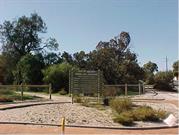
Signal Hill Bushland covering 3.87 hectares is a small remnant of Banksia woodland in the City of Belmont.
Pathways of compacted earth cross the park and entry and exit points control the access to the park.
1829 Signal Hill part of a 2000 acre selection (Swan Loc. 33) granted to Mr James Henty. Location 33 was transferred to Philip Dod a few months later.
1831 Philip Dod exchanged loc 33 with John Hardey. John Hardey was a prominent Perth citizen and had tenure of Loc. 33 for most of the next 50 years, living at his property Grove Farm. By the mid 1870s the Hardey family owned most of what is now the City of Belmont.
In 1912, a portion of Loc. 33 was purchased by Town Properties of WA and in the following year Town Properties of WA made a gift to the Belmont Park Road Board of lots 324 and 325 in Loc 33, so that the gifted land could be used for recreational purposes.
The Road Board purchased the other two lots (lots 313 and 314) for £92. The latter two lots took up most of the present day signal hill site.
In 1939/40. the Commonwealth Government resumed a 17 acre reserve bounded by Alexander Road and Belgravia, Daly and Esther Streets from the Belmont Road Board as part of a future communications network. Radio towers were erected on this block, which has been known ever since as Signal Hill.
The towers were used to communicate with aircraft and to guide Boomerang and Wirraway aircraft into Guildford Airport.
In 1946, the Commonwealth acquired Signal Hill from the Belmont Park Roads Board for the Air Force and in 1948 the Army took over Signal Hill from the Air Force.
By 1974, Signal Hill was surplus to requirements and the Army disposed of the site to the Department of Administrative Services.
In 1977, Signal Hill was sold to Rural and Industries Bank by the Commonwealth and in 1979 the Rural and Industries Bank sold Lot 96 (Signal Hill) to the City of Belmont.
In 1992, the City of Belmont proposed to develop Signal Hill for housing but a referendum of Belmont citizens found 80% wanting Signal Hill retained as natural bushland.
In 1994, the site was rezoned from Residential to Parks and Recreation and Signal Hill Bushland Management Plan was prepared. The site was designated a natural bush reserve and continues to be cared for by volunteers.
Integrity: High
Authenticity: High
Good
Landscape
| Epoch | General | Specific |
|---|---|---|
| Original Use | PARK\RESERVE | Park\Reserve |
| Present Use | PARK\RESERVE | Park\Reserve |
| General | Specific |
|---|---|
| SOCIAL & CIVIC ACTIVITIES | Community services & utilities |
This information is provided voluntarily as a public service. The information provided is made available in good faith and is derived from sources believed to be reliable and accurate. However, the information is provided solely on the basis that readers will be responsible for making their own assessment of the matters discussed herein and are advised to verify all relevant representations, statements and information.