Local Government
Harvey
Region
South West
484 Clifton Rd Brunswick
approx 5kms W of South Western Hwy through Brunswick Junction on N side of road opposite junction with Alverstoke Rd. Originally described as located in Brunswick Junction. Encompasses pastoral property, all the cottages & other outbuildings, a dairy that has been converted to a restaurant, a schoolroom, heritage rose garden, old fruit trees & other cultural features.
Harvey
South West
Constructed from 1842, Constructed from 1886
| Type | Status | Date | Documents | More information |
|---|---|---|---|---|
| State Register | Registered | 05 Jan 2001 |
Register Entry Assessment Documentation |
Heritage Council |
| Type | Status | Date | Documents |
|---|---|---|---|
| (no listings) |
| Type | Status | Date | Grading/Management | More information | |
|---|---|---|---|---|---|
| Category | Description | ||||
| Register of the National Estate | Indicative Place |
|
Heritage Council | ||
| Classified by the National Trust | Classified | 11 Jun 2001 |
|
Heritage Council | |
| Municipal Inventory | Adopted | 27 Oct 2015 | Category 1 |
Category 1 |
|
The following statements are drawn from the Register Documentation for the inclusion of Alverstoke on the State Register of Heritage Place
• The place has historic value as one of the original properties allocated to settlers of the Australind scheme, and specifically as the property allocated to Marshall Waller Clifton who was the Chief Commissioner of the Western Australian Company;
• The place has rarity value as one of a small number of farms in the South-West region that was established during the first two decades of European settlement in Western Australia which has survived in a relatively intact state;
• The place has the potential of being an important research site. The homestead complex contains substantial evidence of material culture that could usefully inform the study of early European settlement and culture in Western Australia through archaeological investigation. An area to the immediate north of the homestead complex, on the bank of the Brunswick River, is known to have been an Aboriginal campsite until the early 1900s;
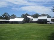
• The place has aesthetic values as a homestead complex which contains a large collection of rustic farm buildings in a landscaped setting, bounded on two sides by a meandering watercourse and large native trees, and for the rest by open fields;
• The place is an extensive and relatively intact collection of farm buildings and associated features that illustrate aspects of building construction, animal farming and horticulture over an extended period of time (1840s to the present). Some of the practices illustrated by the fabric are no longer in practice in Western Australia;
• The older buildings have considerable value as examples of vernacular building forms typical of the nineteenth century. As a collection, Alverstoke demonstrates the physical qualities of a well-developed homestead complex containing buildings of several generations;
• The split slab buildings are rare examples of a construction technique no longer practised in Western Australia; and,
• The place has established a local reputation for its scenic qualities.
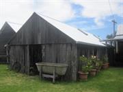
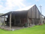
Historically important homestead dating from 1886 with additional outbuildings dating from the early settlement era of 1842 including a barn and small cottage, two stables, three sheds (1850s), workshop, original dairy, new dairy, single man's room (1900), machinery shed (1930s), hay shed (1940s) and a mature olive tree dating from the 1840s and a pear tree from the same period.
The original cottage is constructed of rough hewn jarrah logs set vertically to form the walls with original internal surfacing of wattle and daub. Corrugated iron gable roof and sawn planks forming the gable ends. A brick fire place and chimney is set into one side wall with original internal surfacing of wattle and daub with casement windows on either side.
Alverstoke was established in July 1841 by Marshall Waller Clifton, who named it after his birthplace in Hampshire, England. He and his wife Elinor, along with their family of 13 children, developed it into the first farm in the district, growing wheat, barley and potatoes, and producing milk and cream from their dairy herd. The heavily timbered bush was cleared and a sawmill was established in 1844. A number of thatched buildings were erected and most are still standing having been restored. These include an original cottage and stables (c1841), dairy, barn, homestead (1886), and the Clifton School.
The property is still associated with the Clifton family and operates as a farm and as a function centre. In 2010 major restoration works were undertaken at the place.
High/ High
Good
| Library Id | Title | Medium | Year Of Publication |
|---|---|---|---|
| 9607 | Alverstoke, Brunswick Junction: fifth (final) report, July 2010. | Conservation works report | 2010 |
| 9496 | A report on conservation works at "Alverstoke" homestead, Clifton Road, via Brunswick Junction, Western Australia 6224. | Conservation works report | 2010 |
| 7079 | Alverstoke homestead, Brunswick Junction, Harvey : conservation works. | Conservation works report | 2002 |
| 4352 | Alverstoke, Brunswick Junction, WA : conservation plan. | Heritage Study {Cons'n Plan} | 2000 |
| 5056 | Alverstoke Homestead, Brunswick Junction, Harvey : conservation works. June 2001 | Report | 2001 |
| 11593 | Alverstoke, Brunswick Junction: Third & final report | Conservation works report | 2012 |
Individual Building or Group
| Epoch | General | Specific |
|---|---|---|
| Original Use | FARMING\PASTORAL | Cottage |
| Original Use | RESIDENTIAL | Single storey residence |
| Original Use | INDUSTRIAL\MANUFACTURING | Dairy, Butter or Cheese Factory |
| Original Use | EDUCATIONAL | Combined School |
| Original Use | FARMING\PASTORAL | Homestead |
| Present Use | FARMING\PASTORAL | Homestead |
| Original Use | FARMING\PASTORAL | Kitchen |
| Original Use | FARMING\PASTORAL | Shed or Barn |
| Style |
|---|
| Vernacular |
| Victorian Georgian |
| Type | General | Specific |
|---|---|---|
| Wall | TIMBER | Weatherboard |
| Wall | TIMBER | Slab |
| Roof | METAL | Corrugated Iron |
| Wall | EARTH | Wattle and Daub |
| Other | BRICK | Common Brick |
| Wall | BRICK | Common Brick |
| General | Specific |
|---|---|
| DEMOGRAPHIC SETTLEMENT & MOBILITY | Land allocation & subdivision |
| OCCUPATIONS | Grazing, pastoralism & dairying |
| PEOPLE | Early settlers |
| PEOPLE | Aboriginal people |
| SOCIAL & CIVIC ACTIVITIES | Education & science |
This information is provided voluntarily as a public service. The information provided is made available in good faith and is derived from sources believed to be reliable and accurate. However, the information is provided solely on the basis that readers will be responsible for making their own assessment of the matters discussed herein and are advised to verify all relevant representations, statements and information.