Local Government
Rockingham
Region
Metropolitan
623 Safety Bay Rd Waikiki
Lot 261 on Plan 6379
Rockingham
Metropolitan
Constructed from 1960
| Type | Status | Date | Documents | More information |
|---|---|---|---|---|
| Heritage List | Adopted | 24 Apr 2018 |
| Type | Status | Date | Documents |
|---|---|---|---|
| (no listings) |
| Type | Status | Date | Grading/Management | More information | |
|---|---|---|---|---|---|
| Category | Description | ||||
| Municipal Inventory | Adopted | 24 Apr 2018 | Category D |
Category D |
|
• The place has aesthetic value as a simple demonstration of the post war style expressed in brick and asbestos sheeting.
• The place has historic value for its association with the development of Safety Bay in the 1960s.
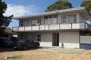
Two storey residence with an open garden comprising of lawn, mature shrubs and trees towards the side boundaries and a low picket fence to one side.
The fibre-cement walls of the house are penetrated by a series of windows along its main northeast façade and an off-centre entrance. The windows are grouped in threes, a larger fixed pane alongside two smaller awning windows, one above the other. The upper storey features a wraparound balcony with a continuous timber balustrade. The balcony can be accessed by a glass door with side and fanlights, roughly above the ground floor entrance below. The roof cannot be seen from street level.
A bitumen crossover is located approximately central on the lot with a concrete driveway expanding towards the house and concrete pavers continuing to the carport between the northwest boundary and side of the house.
Following World War Two Rockingham continued to develop as a popular tourist destination with the suburbs of Rockingham, Palm Beach and Safety Bay being well patronized by holidaymakers. The popular beaches not only attracted more visitors but also permanent residents, settled in the area with their families as industrial sites began to be established in the region.
The suburb of Waikiki was undeveloped in the 1950s. A subdivision plan for this site and the surrounding lots was approved by the Department of Lands in 1954.
This residence was built in the late 1960s as it is not apparent in an aerial photograph of the site in 1965 although the lot does appear to be cleared. It has not been established who was the original owner or occupant of this residence. Aerial photographs indicate that the residence has not changed significantly in form or extent since its construction.
Integrity: High
Authenticity: High
Fair
Individual Building or Group
| Epoch | General | Specific |
|---|---|---|
| Present Use | RESIDENTIAL | Single storey residence |
| Original Use | RESIDENTIAL | Single storey residence |
This information is provided voluntarily as a public service. The information provided is made available in good faith and is derived from sources believed to be reliable and accurate. However, the information is provided solely on the basis that readers will be responsible for making their own assessment of the matters discussed herein and are advised to verify all relevant representations, statements and information.