Local Government
Albany
Region
Great Southern
35615 Albany Hwy Willyung
131 Parker Brook Road, DROME 6330
Albany Airfield
Radar Station
Sigint Radar System
Signals Intelligence Radio Monitor System
Albany
Great Southern
Constructed from 1942
| Type | Status | Date | Documents | More information |
|---|---|---|---|---|
| Heritage List | Adopted | 27 Oct 2020 |
| Type | Status | Date | Documents |
|---|---|---|---|
| (no listings) |
| Type | Status | Date | Grading/Management | More information | |
|---|---|---|---|---|---|
| Category | Description | ||||
| Municipal Inventory | Adopted | 30 Jun 2001 | Category B |
Category B |
|
| Local Heritage Survey | Adopted | 27 Oct 2020 | Considerable |
Considerable |
|
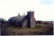
The Sigint Radio Monitoring System, a concrete and steel building, has cultural heritage significance for the following reasons:
It is one of four sites in Albany that connect to the story of the RAAF operations in Albany during the Second World War and the detachment of the No. 14 Squadron who were located in Albany during the war.
As part of a group of RAAF installations, the Sigint would have played a key role as the key communications centre for the allied forces, to provide position plots for civil and courier aircraft and activate air raid warnings as required.
Some of the notable features of this place include:
• Set close to the east side of Albany Highway within the perimeter of the Albany Airfield
• Concrete construction built to resist aerial bombing attacks
• Domed, Nissan Hut shape
Albany was a major link in the defence of Western Australia in a period when there was a real threat of Japanese attack. It was an important port being second only to Fremantle and it became the centre of a coastal patrol network as well as an operational base unit for the servicing and refuelling of planes. The Signit (or Radar Station - High Frequency Detection Finder (HF/DF)) is one of four sites that connect to the story of the RAAF operations in Albany during the Second World War and the detachment of the No. 14 Squadron who were located in Albany. The other three sites are:
• RAAF Operation and Power Bunker
• 35 Radar Station, Stony Hill
• Power Bunker, Federal Street (land owned by Western Power)
Apart from Stony Hill, the other sites are all located in close proximity to the current airport which was the airfield during the war. The Operation and Power Bunker would have been the key communications centre for the allied forces. Although little information has been located specifically on this bunker, operations centres generally were responsible for activating air raid warnings and to provide position plots for courier and civil aircraft.
The Sigint (Signals Intelligence) station was installed in Albany 1942. It had a building on the west side of the road as well as this concrete bunker on the Albany Airfield. Sigint was a high frequency direction finding unit with the primary role of giving navigation assistance to aircraft but could also track enemy planes or ships. Another function was to monitor Japanese transmissions. Albany therefore became the centre of the South West defence. After the war this place became the Federal Street Substation of the State Energy Commission. Except for the remaining bunker, surplus buildings and redundant equipment were sold at public auction.
Despite the presence of the Sigint station, an Observer Corps unit was established in Albany during 1942-1944. This organisation depended on ground observers sighting, identifying, recording and reporting passing aircraft.
Integrity: High/Moderate
Authenticity: High
Fair
| Ref ID No | Ref Name | Ref Source | Ref Date |
|---|---|---|---|
| L Johnson; "Town of Albany Heritage Survey". | City of Albany | 1994 | |
| Heritage TODAY Site visit and Assessment | 1999 | ||
| L Peet; "World War II Military Aviation Sites Survey in Western Australia". | Aviation Heritage Museum of WA | 1996 |
Individual Building or Group
| Epoch | General | Specific |
|---|---|---|
| Present Use | VACANT\UNUSED | Vacant\Unused |
| Original Use | Transport\Communications | Air: Other |
| Type | General | Specific |
|---|---|---|
| Wall | CONCRETE | Other Concrete |
| General | Specific |
|---|---|
| OUTSIDE INFLUENCES | World Wars & other wars |
This information is provided voluntarily as a public service. The information provided is made available in good faith and is derived from sources believed to be reliable and accurate. However, the information is provided solely on the basis that readers will be responsible for making their own assessment of the matters discussed herein and are advised to verify all relevant representations, statements and information.