Local Government
Serpentine-Jarrahdale
Region
Peel
Millbrace Glen Byford
end of Millbrace Glen
Serpentine-Jarrahdale
Peel
Constructed from 1913
| Type | Status | Date | Documents | More information |
|---|---|---|---|---|
| (no listings) |
| Type | Status | Date | Documents |
|---|---|---|---|
| RHP - Does not warrant assessment | Current | 25 Sep 2015 |
| Type | Status | Date | Grading/Management | More information | |
|---|---|---|---|---|---|
| Category | Description | ||||
| Local Heritage Survey | Adopted | 19 Sep 2022 | Category 4 |
Category 4 |
|
The railway bridge has historical significance as a reminder of the development of the railway in the region. It may also bear some scientific significance in its method of construction.
One of the wide-ranging State Government industrial enterprises initiated following the Government Trading Concerns Act (1912), which together had a significant social and economic impact on the development of Western Australia. The place was the only surviving railway infrastructure known to have been constructed specifically to facilitate the establishment of a State Government Trading Concern and was representative of the wide range of structures that were constructed across the State in the years immediately following the Government Trading Concerns Act (1912) to implement government industries.
The Brickworks Railway Bridge (former) was an integral part of the siding providing rail access to two government industrial sites, the State-operated Brickworks north of the bridge (1915-1964) and the Commonwealth-operated Naval Ordnance Depot south of the bridge (1942-1981), providing evidence of the impact of government industries in local areas.
The Brickworks Railway Bridge (former) was a good representative example of a standard pre-World War Two railway bridge of moderate size. It demonstrated the infrastructure required to establish a major industrial operation, and the dependence of many industries on railways in the first half of the twentieth century and was associated with the brick making industry, one of the most important local industries through the twentieth century.
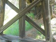
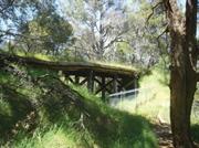
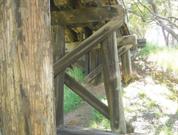
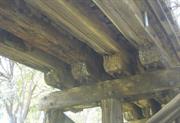
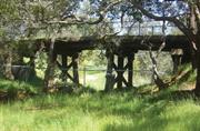
Brickworks Railway Bridge (former) comprised a five-span timber bridge. It was 3 metres wide. Overall length was 22.7 metres and headroom was 4.1 metres. The bridge was slightly curved and had some super elevation. It traversed Beenyup Brook, a shallow water course generally dry in summer. Its immediate surrounds were unkept grass and remnant natural vegetation including several large Marri Trees. Constructed from Jarrah, it had markings XII/XVII^; XIII/XXI^ on the support structures.
The railway bridge was constructed in 1913 to access the State Brickworks at Beenyup/Byford.
Initially planned as a dead end along a kiln, the siding was actually constructed as a loop to allow two kilns to be located at the site. Construction of the siding was completed in August 1913 and linked with the main South West line south at Beenup Station. This was the first stage of the construction of the State Brickworks as it enabled materials to be more easily transported to the site
Byford was formerly known as Beenup.
The brickworks operated as a State Government Trading concern until 1961, then in private ownership until 1964, after which the works were demolished. Throughout this time, the rail siding provided access to the plant, allowing for deliveries, especially of coal, and for transport of completed bricks. Workers also travelled by train.
From 1942, the siding was also used by the Commonwealth to provide access to a Naval ordnance Depot, located between the main line and Brickworks Railway Bridge (former).
The railway bridge ceased to be used by rail vehicles once the State Brickworks closed in the 1960s.
Residential subdivision of the area from the 1990s increased the pedestrian traffic over the bridge. Structural assessment in 2002 determined it was not safe and it was subsequently closed to pedestrians in 2003.
Transport and Communication
1894-1920
Outside Influences
1870-1894
A steel post and wire fence was erected along the length of both sides of the bridge in the 1990s to accommodate safe pedestrians crossing. Only earthen grading remains.
Site only
| Ref Number | Description |
|---|---|
| SJ1-01 | Local Heritage Survey |
Historic site
| Epoch | General | Specific |
|---|---|---|
| Present Use | SOCIAL\RECREATIONAL | Other |
| Original Use | Transport\Communications | Rail: Other |
| Type | General | Specific |
|---|---|---|
| Other | TIMBER | Other Timber |
| General | Specific |
|---|---|
| OUTSIDE INFLUENCES | World Wars & other wars |
| TRANSPORT & COMMUNICATIONS | Rail & light rail transport |
This information is provided voluntarily as a public service. The information provided is made available in good faith and is derived from sources believed to be reliable and accurate. However, the information is provided solely on the basis that readers will be responsible for making their own assessment of the matters discussed herein and are advised to verify all relevant representations, statements and information.