Local Government
Bridgetown-Greenbushes
Region
South West
South Western Hwy Bridgetown
(220a H.9 at SLKm 243.97 Map 1, WG4)
Blackwood River Road Bridge (220a)
Bridge No 220 & Bridge No. MRWA 220a
Bridgetown-Greenbushes
South West
Constructed from 1981
| Type | Status | Date | Documents | More information |
|---|---|---|---|---|
| (no listings) |
| Type | Status | Date | Documents |
|---|---|---|---|
| RHP - To be assessed | Current | 12 Dec 2003 |
| Type | Status | Date | Grading/Management | More information | |
|---|---|---|---|---|---|
| Category | Description | ||||
| Statewide Lge Timber Str Survey | Completed | 11 Dec 1998 |
|
Heritage Council | |
| Municipal Inventory | Adopted | 29 Mar 2018 | Management Category B |
Management Category B |
|
| Municipal Inventory | Adopted | 28 Jun 2001 | Category 3 |
Category 3 |
|
Bridgetown and the Blackwood District could not have thrived without the reliability of strong bridges to connect the north and south sides of the Blackwood river, allowing the transport of people and goods coming in, out and within the area. Each bridge was an engineering achievement, showing both engineering and local development.
Aesthetic Value
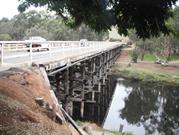
The Blackwood Bridge is of high aesthetic value. It is quite appealing, with timber pylons, unlike many other bridges constructed of steel in the early 1980’s. It is a cultural landmark that gives a sense of place to residents of the district, as a southern entry statement to Bridgetown.
Historic Value
The current bridge is part of the historic evolution of bridges over the Blackwood River in Bridgetown and is of moderate historic value.
Research Value
NA
Social Value
As a physical connection between the southern and northern banks of the Blackwood River, the bridge and its predecessors have allowed the district to flourish.
The bridge forms part of a recreation area, linking the adjacent Blackwood River Park to town via vehicle or pedestrian pathways, which also forms part of a circular walk trail.
The Bridge provides a vital and ongoing link in the road network of the South West and nationally as part of Highway One, connecting the Blackwood and Warren regions.
Timber bridge with concrete deck of 129.6m long and 10.88m wide, including the walkway. The guard rails were originally timber, but have replaced with steel. The timber handrail on the eastern side was replaced with steel early 2016.
The first Blackwood Bridge, in proximity to Ford House, was constructed in 1862, under the management of W Forrest (Lord Forrest’s Father), but was swept away by flood waters as it neared completion.
The second Blackwood Bridge was built at the very end of Hampton Street, with ‘Bridgedale’ and the original Police Station on the western side of the bridge. In 1881 a third, stronger bridge was built by GW Floyd of Bunbury using convict labour, again with Joseph Smith as foreman. This bridge also started at the very end of Hampton Street, but skewed slightly to the south-east.
The fourth bridge was built in 1936 under the management of Main Roads Department, at which time South Western Highway was re-aligned to its current position, as a continuation off Hampton Street at the junction of Carey Street, to cross the river on the western side of ‘Bridgedale’. This was the first of the bridges to be built using milled timber.
The fifth and current bridge was built in 1981, at a time when wooden bridges were being phased out. The northern point for this bridge is alongside the previous bridge, but was built angled to the south east. The remains of the pylons to Bridge No.4 can still be seen below the northern parking bay beside the bridge, when the river is low.
High Integrity: The current bridge remains in full use as a road and foot bridge.
Medium Authenticity: All rails have now been changed to steel, while the structural poles remain timber.
Good
| Ref ID No | Ref Name | Ref Source | Ref Date |
|---|---|---|---|
| inHerit database Place Number 2995 | |||
| Main Roads WA staff | |||
| Fran Taylor | Bridgetown the Early Years |
| Ref Number | Description |
|---|---|
| NA | Assess No (Shire Ref) |
| No.B43 | MI Place No. |
Historic site
| Epoch | General | Specific |
|---|---|---|
| Original Use | Transport\Communications | Road: Bridge |
| Present Use | Transport\Communications | Road: Bridge |
| Type | General | Specific |
|---|---|---|
| Other | TIMBER | Other Timber |
| General | Specific |
|---|---|
| TRANSPORT & COMMUNICATIONS | Road transport |
| DEMOGRAPHIC SETTLEMENT & MOBILITY | Technology & technological change |
This information is provided voluntarily as a public service. The information provided is made available in good faith and is derived from sources believed to be reliable and accurate. However, the information is provided solely on the basis that readers will be responsible for making their own assessment of the matters discussed herein and are advised to verify all relevant representations, statements and information.