Local Government
York
Region
Avon Arc
2-12 Redmile Rd York
Part of Blandstown Heritage Precinct
York
Avon Arc
Constructed from 1853, Constructed from 1870
| Type | Status | Date | Documents | More information |
|---|---|---|---|---|
| (no listings) |
| Type | Status | Date | Documents |
|---|---|---|---|
| (no listings) |
| Type | Status | Date | Grading/Management | More information | |
|---|---|---|---|---|---|
| Category | Description | ||||
| Classified by the National Trust | Classified | 25 Sep 1985 |
|
Heritage Council | |
| Register of the National Estate | Registered | 31 Mar 1978 |
|
Heritage Council | |
| Local Heritage Survey | Adopted | 25 Nov 2019 | Exceptional Significance |
Exceptional Significance |
|
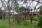
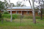
Redmile House is of considerable historic significance as a rare mostly intact 1853 and 1870 dwellings and the beehive well located at the river crossings (Parker’s Bridge over the Avon River and Heal’s Bridge over Blands Brook) and Balladong Farm juncture of the important early route of Redmile Road to and from Balladong Farm, the Pensioner Guard establishment and linking to Great Southern Highway. Redmile House demonstrates way of life for early settlers, a gallon licence and store that outfitted expeditions and provided general stores, enterprises that are no longer practiced. It is important for its association with early settlers including S (Charles?) Redmile, and later O Sergant, botanist and pharmacist. Redmile House makes a considerable contribution to the historic townscapes of the Blandstown precinct, and the town of York.
The 1853 dwelling is raised above ground level on the south side (street front). It is typically one room deep along the expansive frontage is symmetrical with a central door and two balanced openings each side. The window openings evidence different styles. The brick work is detailed in reverse tone Flemish bond. Part of the front wall has a rendered dado. The hipped roof is clad with corrugated iron and the front veranda has a separate skillion roof hipped at the corner, and supported by square timber posts.
The 1870 dwelling is located to the west of the 1853 dwelling and aligned north-south. It is single storey with a hipped roof. It is two rooms deep with a front veranda under the extension of the high-pitched roof. Tall face brick chimneys with a single corbel brick at the top, are evident each side of the dwelling. Windows on the front have been replaced with aluminium framed glazing, and the wall is rendered to dado height.
The face brick beehive well is located north of the 1853 dwelling.
After York was opened for selection in 1830, the first settlers, arrived in 1831 from the Swan River settlement with the task of establishing a Government Farm. Balladong Farm was settled in 1831 by William Heal, later H. Bland after whom Blandstown is named. Stephen Stanley Parker had arrived in the Colony with his parents in 1830. After marrying Elizabeth Sewell in 1844 he purchased Balladong Farm in 1848. During the 1850s, Parker developed the property into a very successful farm. He built stone stables and a granary, and employed many ticket of leave men. In 1858, Parker erected a large steam flourmill and began a flour milling business.
Balladong farm’s original entry was off Redmile Road across Heals Bridge that was close to the Avon River (Parker’s Bridge) crossing to access the Pensioner Guard establishment, Redmile House (trading post) and along Redmile Road to Avon Terrace (Great Southern Highway).
In 1861, Parker's Bridge was constructed over the Avon on Redmile Road at the site of an existing ford. The York convict barracks were located on the eastern side of the bridge. Redmile House, was located on Redmile Road, opposite Bridge House, had a gallon licence and a shop. SS Parker availed Redmile’s premises and stockyards as the departure and return venue for various exploratory expeditions. The most notable being the Henry Maxwell Lefroy Expedition of 1863 and Charles C. Hunt's Expedition of 1864.
The house was established by S (Charles?) Redmile. The place was known as Riverview House during the time of Redmile’s occupancy. Obeitho Sargent a Botanist/chemist was an occupant during which time he constructed the distinctive Sargent’s Pharmacy building in Avon Terrace.
Integrity: Moderate
Authenticity: High
Fair
| Ref ID No | Ref Name | Ref Source | Ref Date |
|---|---|---|---|
| "Blandstown Conservation Plan". |
Individual Building or Group
| Epoch | General | Specific |
|---|---|---|
| Present Use | RESIDENTIAL | Single storey residence |
| Original Use | RESIDENTIAL | Single storey residence |
| Style |
|---|
| Victorian Georgian |
| Type | General | Specific |
|---|---|---|
| Wall | BRICK | Common Brick |
| Wall | METAL | Corrugated Iron |
This information is provided voluntarily as a public service. The information provided is made available in good faith and is derived from sources believed to be reliable and accurate. However, the information is provided solely on the basis that readers will be responsible for making their own assessment of the matters discussed herein and are advised to verify all relevant representations, statements and information.