Local Government
Cambridge
Region
Metropolitan
Oceanic Dr, Rochdale Rd City Beach
Bounded to the north by the Boulevard, then sth along Kalinda Drive to Oceanic Drive, then east along Oceanic Drive to West Coast Hwy, then nth along Challenger Drive to the beach, then sth along the beach to Swanbourne Beach at North Street then east inland past the Swanbourne Rifle Range, then nnw along Stephenson Ave, along Perry Lakes Drive to the intersection with Oceanic Drive then along Oceanic Drive to Bold Park Drive, then north along Bold Park Drive to the Boulevarde
Cambridge
Metropolitan
Constructed from 1917
| Type | Status | Date | Documents |
|---|---|---|---|
| Heritage List | Adopted | 27 Nov 2018 |
| Type | Status | Date | Documents |
|---|---|---|---|
| (no listings) |
| Type | Status | Date | Grading/Management | |
|---|---|---|---|---|
| Category | ||||
| Municipal Inventory | Adopted | 27 Nov 2018 | Category 2 | |
| Municipal Inventory | Adopted | 17 Dec 1996 | ||
| Classified by the National Trust | Classified {Lscpe} | 07 Dec 1992 | ||
| Register of the National Estate | Indicative Place | |||
The place has aesthetic value as a large well maintained parkland within a suburban setting that is accessible to the community. The place has historic value as a remnant of the coastal bushland in the metropolitan area that has remained intact since the early 19th century. The place has historic value for its associations with prominent settlers Walter Padbury, Henry Trigg and Joseph Perry, who were significant figures in the early development of Western Australia; The place has historic value for its association with William Ernest Bold who was an influential leader in the City of Perth who shaped the development of this portion of the Town of Cambridge in the early 20th century; The place has research value as the largest remaining bushland remnant in the urban area of the Swan Coastal Plain. The tuart-banksia woodlands and limestone heaths support a number of habitats for wildlife. The place has social value for the members of the community who access the place for passive recreation and research. The place has social value as demonstrated by the formation of the Friends of Bold Park Bushland Inc., a community group dedicated to the ongoing care and maintenance of the park.
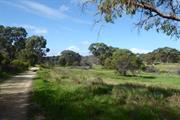
Bold Park is an extensive area of natural environment, parklands and bush, bounded by Oceanic Drive, West Coast Highway, Perry Lakes Drive and Rochdale Road, totalling 437 hectares and is the largest remaining bushland within the urban area of the Swan Coastal Plain. The portion of land to the south of Rochdale Road bordered by West Coast Highway to the west can be considered part of the original landholding and its physical form, fauna and flora are consistent with Bold Park. A further section of Bold Park is found to the north of Oceanic Drive, extending along Bold Park Drive and bordered by The Boulevard to the north and Kalinda Drive (not including the International School site or the Town of Cambridge Administration Centre). The park contains a number of features including Camel Lake, Pine Plantation, Reabold Hill and various heritage trails and nature walks and together with a number of lookouts providing long views across the City and out towards the Indian Ocean. The park also contains Perry House built in the early 1900s for the caretaker of the park (see separate entry). The parcel of land south of Rochdale Road is more informal in nature with no facilities such as graded paths or signage.
The area now defined as Bold Park has been registered as Aboriginal Site place 20178 and recognised for the following associations; historical, mythological, camp, hunting place, plant resource, and lookout point. Following the foundation of Perth in August 1829, the townsite was laid out between Mount Eliza and what was to later become Heirisson Island. Limestone was in great demand for construction in the new colony. The earliest lime kilns in Western Australia were established at the initial settlement sites of Fremantle and Albany in the 1830s, where settlers had access to local supplies of limestone. Henry Trigg, a carpenter and master builder from Gloucester, England arrived in the new colony of Western Australia in 1829. In I 834, Trigg was granted 500 acres of land, which lay south of modern day Grantham Street, stretching from Floreat to the coastal sand hills. The western boundary of Trigg's land ran along the top of a limestone ridge. As a builder, Trigg recognised the value of this limestone outcropping and set up a quarrying and lime burning business. Trigg's business which became known as the 'Limekilns' prospered. In 1839, Trigg purchased neighbouring land to the south, including what is now Perry Lakes and One Tree Hill, (now known as Reabold Hill). In the same year, Trigg was appointed Superintendent of Public Works, and in this role was responsible for overseeing the erection of many early government buildings in Perth. In 1844, Walter Padbury, a pastoralist, acquired 426 acres of land adjacent to Trigg's property and later purchased Trigg's land including the Limekilns business for 2350, forming a 1,234 acre landholding which became known as the 'Limekilns Estate'. For the next 20 years Padbury built the Estate into a successful property, including the retention of the quarrying operations. At the height of operations, more than 50 men were employed at the quarry and lime kiln site. In 1869, brothers Henry and Somers Birch purchased the Limekilns Estate from Walter Padbury for £1,000. On 1 November 1875, during their ownership of the property, the explorer Ernest Giles arrived in Perth after his 2,500 mile journey from Port Augusta. His camels were rested at the Limekilns Estate and later in the 1890s, the Limekilns Estate served as a temporary quarantine station for camels imported to Western Australia to provide transport to the goldfields, with a lake now within Bold Park becoming known as Camel Lake. The Estate remained in the Birch's ownership until, 1880 when it was purchased by Joseph Perry for the sum of £1300. During his ownership, Perry kept the Quarry and limekilns in operation. Many of Perth's early public buildings, including the foundations of the Perth Town Hall (1870) were constructed using limestone from the quarry and kilns. In 1880, a portion of the Limekilns property was rented to Charles Ball who offered to supply lime which was described as the most superior in the colony, from lime kilns of 30 years standing. Private quarrying ceased operation in 1906 and the Limekilns Quarry (Quarry Amphitheatre) remained disused for many years. Changes to the rural nature of the area came about with the subdivision of land owned by the Catholic Church in 1911. This subdivision was called the Church Lands Estate, and the first house was constructed in 1912. In 1917, the Perth City Council purchased the 1290-acre Limekilns Estate from Perry for £18,000 and it linked to the Endowment Lands bestowed on the Perth City Council by the State Government in 1902. In January 1918, the Limekilns Estate was included within the boundaries of the City of Perth, and adjoined a further 2281 acres of Endowment Lands. The City envisioned opening out the quarries and using the limestone in the construction of city roads but also setting a portion of the land aside for a public park on the site of Perry's couch paddock and One Tree Hill (Reabold Hill). The exact date that the municipal Quarry ceased operation is not known, but it is likely that operations ceased in the 1920s with the beginning of the development of the area for housing. During the middle decades of the 20th century the quarry was unused and largely inaccessible. In 1919, One Tree Hill was renamed Reabold Hill after F. R Rea, the Mayor of Perth at the time the property was acquired by the City of Perth and W. E. Bold, the town clerk. By this time the lone Tuart tree that had previously sat atop the 286 ft. high hill, and given the place its name had disappeared. In 1925, an area of land of approximately 1000 acres was set aside as a place of recreation and was the early 1900s in response to improving residential amenities for workers in nineteenth century industrial cities. The definition of a Garden City as a town designed for healthy living, surrounded by a rural belt of land owned or held in trust for the community directly influenced the planning of Floreat Park and City Beach as two satellite towns separated by a belt of undeveloped land (Bold Park). Other sources have designated that the naming occurred in 1936. Over the years, the City of Perth maintained Bold Park and Reabold Hill as places of recreation. By the 1960s, the area was surrounded by suburban housing. In 1987, the Friends of Bold Park Bushland Inc. was established to protect and conserve the park. Their role as a lobby group was significant in the decision to declare Bold Park an A-class reserve on 10 August 1998 for its high conservation, landscape and recreation values and vested with the Botanic Gardens and Parks Authority for management. Volunteers from the group work on regeneration projects, raise community awareness and provide free guided walks through the bushland. The Western Australian Ecology Centre is located on Perry Lakes Drive, City Beach. Bold Park visitor information is displayed at the building entry. Officially opened in August 2004, the Western Australian Ecology Centre was initiated as a key strategy in the inaugural Bold Park Environmental Management Plan 2000-2005 to provide a venue to assist community groups, environmental practitioners and educators to undertake their activities, and to provide office space for staff involved in Bold Park's ongoing management. The park continues to be used for passive recreation with walk paths, playgrounds and activities for a wide range of community members. The parcel of land south of Rochdale Road which has a similar physical form and historical use has not been developed by the Town of Cambridge.
Integrity: High Authenticity: High
| Ref ID No | Ref Name | Ref Source | Ref Date |
|---|---|---|---|
| Botanic Gardens and Parks Authority | Website | 2016 | |
| Aerial photographs, Landgate. | Online Reference | 1953-2016 | |
| M McCotter;"Bold Park and Environs: Public Environmental Review (Draft)". | City of Perth | Jan 1993 |
Landscape
| Epoch | General | Specific |
|---|---|---|
| Present Use | PARK\RESERVE | Park\Reserve |
| Original Use | PARK\RESERVE | Park\Reserve |
| General | Specific |
|---|---|
| PEOPLE | Early settlers |
| PEOPLE | Aboriginal people |
This information is provided voluntarily as a public service. The information provided is made available in good faith and is derived from sources believed to be reliable and accurate. However, the information is provided solely on the basis that readers will be responsible for making their own assessment of the matters discussed herein and are advised to verify all relevant representations, statements and information.