Local Government
York
Region
Avon Arc
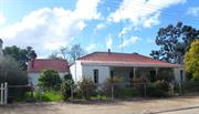
24 Tenth Rd York
Lot 802
York
Avon Arc
| Type | Status | Date | Documents |
|---|---|---|---|
| (no listings) |
| Type | Status | Date | Documents |
|---|---|---|---|
| (no listings) |
| Type | Status | Date | Grading/Management | |
|---|---|---|---|---|
| Category | ||||
| Local Heritage Survey | Adopted | 25 Nov 2019 | Grade C | |
Good; Authenticity and Integrity = Fair as per 2007 MI
Individual Building or Group
| Epoch | General | Specific |
|---|---|---|
| Present Use | RESIDENTIAL | Single storey residence |
This information is provided voluntarily as a public service. The information provided is made available in good faith and is derived from sources believed to be reliable and accurate. However, the information is provided solely on the basis that readers will be responsible for making their own assessment of the matters discussed herein and are advised to verify all relevant representations, statements and information.

Constructed from 1950
Residence, 24 Tenth Road is a representative example of post war austerity with the typical louvred veranda enclosure, demonstrating a period of development in the north of town and makes a contribution to the historical townscape of York.
Single storey with a protruding front and return front and side verandas. The hipped roof breaks pitch over the verandas. The side veranda is enclosed with louvred windows above a timber framed fibrocement dado. The other side veranda is not visible in this photo. The residence is rendered masonry. The front windows evidence the typical set of three timber–framed casements. The tall chimney seems to be roughcast with a single course of face bricks at the top. The front fence is a low rendered wall with brick piers and a metal horizontal pipes above the rendered dado. Rendered piers at front gate entry. It is likely that the fence is associated with the build of the residence.
Integrity: Moderate/High Authenticity: Low/Moderate
Fair
This information is provided voluntarily as a public service. The information provided is made available in good faith and is derived from sources believed to be reliable and accurate. However, the information is provided solely on the basis that readers will be responsible for making their own assessment of the matters discussed herein and are advised to verify all relevant representations, statements and information.
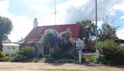
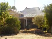
9 Tenth Rd York
Lot 350
York
Avon Arc
| Type | Status | Date | Documents |
|---|---|---|---|
| (no listings) |
| Type | Status | Date | Documents |
|---|---|---|---|
| (no listings) |
| Type | Status | Date | Grading/Management | |
|---|---|---|---|---|
| Category | ||||
| Local Heritage Survey | Adopted | 25 Nov 2019 | Grade C | |
and Authenticity and Integrity = Good as per 2007 MI
Individual Building or Group
| Epoch | General | Specific |
|---|---|---|
| Present Use | RESIDENTIAL | Single storey residence |
This information is provided voluntarily as a public service. The information provided is made available in good faith and is derived from sources believed to be reliable and accurate. However, the information is provided solely on the basis that readers will be responsible for making their own assessment of the matters discussed herein and are advised to verify all relevant representations, statements and information.

Constructed from 1880
Residence, 9 Tenth Road is a representative example of Victorian Georgian style with additions to both sides of the main residence, retaining the scale and symmetry of the front view. It is part of the early and recent development in the north of town and makes a contribution to the historical townscape of York. Association with Charles Edwards is notable.
Single storey with a hipped roof with a separate skillion front veranda supported by square timber posts with a simple spaced vertical timber valance. A protruding gable detail signals the central entry to the symmetrical frontage with a central front door flanked by multi-paned windows. Additions both sides retain the symmetry.
The Rate books show that Charles (Chas) Edwards owned the property in 1896. In 1897 it is noted there was a house on the site, and is still recorded as owning the place in 1899. Charles Edwards (1850-1927) Born at Seaton Ross, he died at Hartleap. He was an active and committed community member; Councillor and one-time Mayor of York, President of the Agricultural Society, involved in Anglican Church, and owned Edwards Store that later became the York Co-op.
Integrity: Moderate/High Authenticity: Low/Moderate
Fair
This information is provided voluntarily as a public service. The information provided is made available in good faith and is derived from sources believed to be reliable and accurate. However, the information is provided solely on the basis that readers will be responsible for making their own assessment of the matters discussed herein and are advised to verify all relevant representations, statements and information.
12 Thorn St York
Part of Central York Heritage Area P26586
York
Avon Arc
| Type | Status | Date | Documents |
|---|---|---|---|
| (no listings) |
| Type | Status | Date | Documents |
|---|---|---|---|
| (no listings) |
| Type | Status | Date | Grading/Management | |
|---|---|---|---|---|
| Category | ||||
| Local Heritage Survey | Adopted | 25 Nov 2019 | Considerable Significance | |
Individual Building or Group
| Epoch | General | Specific |
|---|---|---|
| Present Use | RESIDENTIAL | Single storey residence |
| Style |
|---|
| Victorian Georgian |
This information is provided voluntarily as a public service. The information provided is made available in good faith and is derived from sources believed to be reliable and accurate. However, the information is provided solely on the basis that readers will be responsible for making their own assessment of the matters discussed herein and are advised to verify all relevant representations, statements and information.

Constructed from 1896
26586 Central York Heritage Area
Residence, 12 Thorn Street is a good representative example of Victorian Georgian architectural style in the early Federation period. It represents associations with JH Monger snr who owned the property as part of Monger’s town and allocated Avon Location X (24 acres) to his son Stephen Monger as part of providing separate property for his four sons that didn’t get along. It is closely associated with the owner builders, Thorn, Bower and Stewart, with the street named after Thorn. Individually and together with the identical residence at 8 and similar at 14 Thorn Street, it makes a contribution to the historical townscape of York.
The residence is single storey with a simple hipped roof and separate skillion front veranda (not original) supported by square timber posts. The front wall evidences reverse tone (dichromatic) Flemish bond brickwork with the lower courses painted, and the side wall rendered. The symmetrical frontage has a central front door flanked by single double-hung sash windows. Two face brick corbelled chimneys are evident.
After York was opened for selection in 1830, the first settlers arrived in 1831 from the Swan River settlement with the task of establishing what was to be an unsuccessful Government Farm. By 1833 the Monger family moved to York, where J. H. Monger Snr. had established a hotel and store, and operated as a merchant for many pastoralists. J. H. Monger Snr. concentrated on his successful merchant business. Until the mid-1850s, J. H. Monger Snr. owned up to 36,000 hectares of freehold and leasehold land before being the first of the larger estates to be subdivided for closer settlement in the mid-1950s. J. H. Monger Snr. was known as the ‘Duke of York’, and competed with R. H. Bland in establishing town centres in York; Monger’s town and Blandstown. John Henry (Snr) and Mary Monger had seven children; John Henry Jnr. (b.1831), Ann Elizabeth (b. & d.1833), Joseph Taylor (b.1834 d.1891), Stephen (b.1836 d.1907), Susannah (b.1839 d.1876), Herbert (b.1840 d.1920), and George (b.1842 d.1893). J. H. Monger Snr. established his four sons in business, although in different areas due to their inability to get along together. It is likely Avon Location X (24 acres) was Stephen Monger’s portion of his father’s allocation. The first Certificate of Title (CT) issued in September 1884 to Stephen Monger, noted him as a farmer of Stanton Springs. Location X was a rectangular section of land bounded by South Street to the north, and what is now Balladong Road to south, Avon River to east, and an arbitrary north/south boundary to west, at a juncture from Avon Terrace including the diagonal Avon Terrace. On 22 December 1884 three portions of Avon Location X were transferred to three different purchasers: Edward Keane, contractor of Guildford (1 acre), Robert Scott of Glen Avon (1 rood), and William Eaton, blacksmith of York (1 rood). It seems from the C.T. plan that the lots may have been in the southeast vicinity of the Avon Terrace and Stephen Street intersection. Stephen Monger transferred a further 1 rood lot to James Butterly of Youngedin, and, on 5 September 1888 12 acres 1 rood to Thomas Henry Thorn, Joseph Bower and Andrew John Stewart, all builders of York, as tenants in common. A further 2 roods were transferred to John Clarkson, in October 1891, 1 acre 1 rood to Joseph Askew Kenworthy in September 1898, 1 acre 1 rood George Noble Morse in May 1899, and Lots 7 and 8 to Joseph McKay in October 1905. In 1896, Thorn, Bower and Stewart took out a mortgage of 1,500 pound to William Marwick snr (discharged in 1901). It is likely that the identical dwellings at Nos 8 and 12 were constructed by them at that time, in anticipation of the subdivision approval. On 10 March 1899, a Certificate of Title was issued for the subdivided site comprising 3 roods 23 perches bounded by Thorn Street to the west. On 7 March 1899, Thomas Henry Thorn died and probate was granted to Clarence Thorn as sole executor. The balance of the property (not the 3 roods and 23 perches) was acquired by Dalgety and Company Ltd in July 1901. The Thorn Street site was numbered lots 1-4 in 1899 when John Barnard of Pearlers Rest Hotel in Shark Bay purchased lots 2 and 3 and sold both lots to Henry Smith, business manager of Thorn Street in 1918. In 1927, part of lot 3 (No.8) was transferred to Mavis Elizabeth Mary Leighton, and lot 2 and north section of Lot 3 (No.12) was sold to Robert Nelson Carson Towell, labourer (later- draper) of Thorn Street. The property changes hands again in 1928 to William warren a labourer of Thorn Street, before Leslie Michael Ashworth, labourer, purchased in 1941, transferred to Charles William Ashworth, blacksmith in 1950, and to Charles Alexander Ashworth a famer of Thorn Street, in 1951. After the death of Charles A Ashworth in 1955, the executor; Philip Haden Sargent of Fairview (York), the property was transferred to widow, Gladys Rose Ashworth. After her death in 1981 there have been several owners.
Integrity: High Authenticity: Moderate
Good
This information is provided voluntarily as a public service. The information provided is made available in good faith and is derived from sources believed to be reliable and accurate. However, the information is provided solely on the basis that readers will be responsible for making their own assessment of the matters discussed herein and are advised to verify all relevant representations, statements and information.
14 Thorn St York
Part of Central York Heritage Area P26586
York
Avon Arc
| Type | Status | Date | Documents |
|---|---|---|---|
| (no listings) |
| Type | Status | Date | Documents |
|---|---|---|---|
| (no listings) |
| Type | Status | Date | Grading/Management | |
|---|---|---|---|---|
| Category | ||||
| Local Heritage Survey | Adopted | 25 Nov 2019 | Considerable Significance | |
Individual Building or Group
| Epoch | General | Specific |
|---|---|---|
| Present Use | RESIDENTIAL | Single storey residence |
| Style |
|---|
| Victorian Georgian |
This information is provided voluntarily as a public service. The information provided is made available in good faith and is derived from sources believed to be reliable and accurate. However, the information is provided solely on the basis that readers will be responsible for making their own assessment of the matters discussed herein and are advised to verify all relevant representations, statements and information.

Constructed from 1898
26586 Central York Heritage Area
Residence, 14 Street is a good representative example of Victorian Georgian architectural style in the early Federation period. It represents associations with JH Monger snr who owned the property as part of Monger’s town and allocated Avon Location X (24 acres) to his son Stephen Monger as part of providing separate property for his four sons that didn’t get along. Individually and together with the identical pair of residences at 8 and 12 Thorn Street, it makes a contribution to the historical townscape of York.
The residence is an elevated single storey with a simple hipped roof and separate skillion front veranda and an enclosed south side veranda. The symmetrical front wall is detailed in white-line- pointed Flemish bond. It has a central front door flanked by multi-paned double-hung sash windows. The front veranda has been semi- enclosed with timber framed fibro-cement cladding. Painted brick corbelled chimneys are evident.
After York was opened for selection in 1830, the first settlers arrived in 1831 from the Swan River settlement with the task of establishing what was to be an unsuccessful Government Farm. By 1833 the Monger family moved to York, where J. H. Monger Snr. had established a hotel and store, and operated as a merchant for many pastoralists. J. H. Monger Snr. concentrated on his successful merchant business. Until the mid-1850s, J. H. Monger Snr. owned up to 36,000 hectares of freehold and leasehold land before being the first of the larger estates to be subdivided for closer settlement in the mid-1950s. J. H. Monger Snr. was known as the ‘Duke of York’, and competed with R. H. Bland in establishing town centres in York; Monger’s town and Blandstown. John Henry (Snr) and Mary Monger had seven children; John Henry Jnr. (b.1831), Ann Elizabeth (b. & d.1833), Joseph Taylor (b.1834 d.1891), Stephen (b.1836 d.1907), Susannah (b.1839 d.1876), Herbert (b.1840 d.1920), and George (b.1842 d.1893). J. H. Monger Snr. established his four sons in business, although in different areas due to their inability to get along together. It is likely Avon Location X (24 acres) was Stephen Monger’s portion of his father’s allocation. The first Certificate of Title (CT) issued in September 1884 to Stephen Monger, noted him as a farmer of Stanton Springs. Location X was a rectangular section of land bounded by South Street to the north, and what is now Balladong Road to south, Avon River to east, and an arbitrary north/south boundary to west, at a juncture from Avon Terrace including the diagonal Avon Terrace. On 22 December 1884 three portions of Avon Location X were transferred to three different purchasers: Edward Keane, contractor of Guildford (1 acre), Robert Scott of Glen Avon (1 rood), and William Eaton, blacksmith of York (1 rood). It seems from the C.T. plan that the lots may have been in the southeast vicinity of the Avon Terrace and Stephen Street intersection. Stephen Monger transferred a further 1 rood lot to James Butterly of Youngedin, and, on 5 September 1888 12 acres 1 rood to Thomas Henry Thorn, Joseph Bower and Andrew John Stewart, all builders of York, as tenants in common. A further 2 roods were transferred to John Clarkson, in October 1891, 1 acre 1 rood to Joseph Askew Kenworthy in September 1898, 1 acre 1 rood George Noble Morse in May 1899, and Lots 7 and 8 to Joseph McKay in October 1905. On 10 March 1899, a Certificate of Title was issued for the subdivided site comprising 3 roods 23 perches bounded by Thorn Street to the west. On 7 March 1899, Thomas Henry Thorn died and probate was granted to Clarence Thorn as sole executor. The balance of the property (not the 3 roods and 23 perches) was acquired by Dalgety and Company Ltd in July 1901. The Thorn Street site was numbered lots 1-4 in 1899 when John Barnard of Pearlers Rest Hotel in Shark Bay purchased lots 2 and 3. There is no further information about Lot 1.
Integrity: High Authenticity: Moderate/High
Fair/Good
This information is provided voluntarily as a public service. The information provided is made available in good faith and is derived from sources believed to be reliable and accurate. However, the information is provided solely on the basis that readers will be responsible for making their own assessment of the matters discussed herein and are advised to verify all relevant representations, statements and information.
8 Thorn St York
Part of Central York Heritage Area P26586
York
Avon Arc
| Type | Status | Date | Documents |
|---|---|---|---|
| (no listings) |
| Type | Status | Date | Documents |
|---|---|---|---|
| (no listings) |
| Type | Status | Date | Grading/Management | |
|---|---|---|---|---|
| Category | ||||
| Local Heritage Survey | Adopted | 25 Nov 2019 | Considerable Significance | |
Individual Building or Group
| Epoch | General | Specific |
|---|---|---|
| Present Use | RESIDENTIAL | Single storey residence |
| Style |
|---|
| Victorian Georgian |
This information is provided voluntarily as a public service. The information provided is made available in good faith and is derived from sources believed to be reliable and accurate. However, the information is provided solely on the basis that readers will be responsible for making their own assessment of the matters discussed herein and are advised to verify all relevant representations, statements and information.

Constructed from 1896
26586 Central York Heritage Area
Residence, 8 Thorn Street is a good representative example of Victorian Georgian architectural style in the early Federation period. It represents associations with JH Monger snr who owned the property as part of Monger’s town and allocated Avon Location X (24 acres) to his son Stephen Monger as part of providing separate property for his four sons that didn’t get along. It is closely associated with the owner builders, Thorn, Bower and Stewart, with the street named after Thorn. Individually and together with the identical residence at 12 and similar at 14 Thorn Street, it makes a contribution to the historical townscape of York.
The residence is single storey with a simple hipped roof and separate skillion front veranda supported by turned timber posts with decorative brackets. The symmetrical frontage has a central front door with fanlight, flanked by single multi-paned double-hung sash windows. The reverse tone Flemish Bond frontage has been painted. A painted-brick corbelled chimney is evident with a clay pot.
After York was opened for selection in 1830, the first settlers arrived in 1831 from the Swan River settlement with the task of establishing what was to be an unsuccessful Government Farm. By 1833 the Monger family moved to York, where J. H. Monger Snr. had established a hotel and store, and operated as a merchant for many pastoralists. J. H. Monger Snr. concentrated on his successful merchant business. Until the mid-1850s, J. H. Monger Snr. owned up to 36,000 hectares of freehold and leasehold land before being the first of the larger estates to be subdivided for closer settlement in the mid 1950’s. J. H. Monger Snr. was known as the ‘Duke of York’, and competed with R. H. Bland in establishing town centres in York; Monger’s town and Blandstown. John Henry (Snr) and Mary Monger had seven children; John Henry Jnr. (b.1831), Ann Elizabeth (b. & d.1833), Joseph Taylor (b.1834 d.1891), Stephen (b.1836 d.1907), Susannah (b.1839 d.1876), Herbert (b.1840 d.1920), and George (b.1842 d.1893). J. H. Monger Snr. established his four sons in business, although in different areas due to their inability to get along together. It is likely Avon Location X (24 acres) was Stephen Monger’s portion of his father’s allocation. The first Certificate of Title (CT) issued in September 1884 to Stephen Monger, noted him as a farmer of Stanton Springs. Location X was a rectangular section of land bounded by South Street to the north, and what is now Balladong Road to south, Avon River to east, and an arbitrary north/south boundary to west, at a juncture from Avon Terrace including the diagonal Avon Terrace. On 22 December 1884 three portions of Avon Location X were transferred to three different purchasers: Edward Keane, contractor of Guildford (1 acre), Robert Scott of Glen Avon (1 rood), and William Eaton, blacksmith of York (1 rood). It seems from the C.T. plan that the lots may have been in the southeast vicinity of the Avon Terrace and Stephen Street intersection. Stephen Monger transferred a further 1 rood lot to James Butterly of Youngedin, and, on 5 September 1888 12 acres 1 rood to Thomas Henry Thorn, Joseph Bower and Andrew John Stewart, all builders of York, as tenants in common. A further 2 roods were transferred to John Clarkson, in October 1891, 1 acre 1 rood to Joseph Askew Kenworthy in September 1898, 1 acre 1 rood George Noble Morse in May 1899, and Lots 7 and 8 to Joseph McKay in October 1905. In 1896, Thorn, Bower and Stewart took out a mortgage of 1,500 pound to William Marwick snr (discharged in 1901). It is likely that the identical dwellings at Nos 8 and 12 were constructed by them at that time, in anticipation of the subdivision approval. On 10 March 1899, a Certificate of Title was issued for the subdivided site comprising 3 roods 23 perches bounded by Thorn Street to the west. On 7 March 1899, Thomas Henry Thorn died and probate was granted to Clarence Thorn as sole executor. The balance of the property (not the 3 roods and 23 perches) was acquired by Dalgety and Company Ltd in July 1901. The Thorn Street site was numbered lots 1-4 in 1899 when John Barnard of Pearlers Rest Hotel in Shark Bay purchased lots 2 and 3 and sold both lots to Henry Smith, business manager of Thorn Street in 1918. In 1927, part of lot 3 (No.8) was transferred to Mavis Elizabeth Mary Leighton, and lot 2 and north section of Lot 3 (No.12) was also sold.
Integrity: High Authenticity: Moderate
Good
This information is provided voluntarily as a public service. The information provided is made available in good faith and is derived from sources believed to be reliable and accurate. However, the information is provided solely on the basis that readers will be responsible for making their own assessment of the matters discussed herein and are advised to verify all relevant representations, statements and information.
Top Beverley Rd York
York
Avon Arc
Constructed from 1895
| Type | Status | Date | Documents |
|---|---|---|---|
| (no listings) |
| Type | Status | Date | Documents |
|---|---|---|---|
| (no listings) |
| Type | Status | Date | Grading/Management | |
|---|---|---|---|---|
| Category | ||||
| Local Heritage Survey | Adopted | 25 Nov 2019 | Grade C | |
Individual Building or Group
| Epoch | General | Specific |
|---|---|---|
| Present Use | RESIDENTIAL | Single storey residence |
| Original Use | FARMING\PASTORAL | Homestead |
| Type | General | Specific |
|---|---|---|
| Wall | BRICK | Common Brick |
| Wall | STONE | Other Stone |
| Roof | METAL | Corrugated Iron |
| General | Specific |
|---|---|
| DEMOGRAPHIC SETTLEMENT & MOBILITY | Settlements |
This information is provided voluntarily as a public service. The information provided is made available in good faith and is derived from sources believed to be reliable and accurate. However, the information is provided solely on the basis that readers will be responsible for making their own assessment of the matters discussed herein and are advised to verify all relevant representations, statements and information.

Constructed from 1890
Lookout is of historical significance as part of the Mt Hardey Estate, one of the original properties in York.
Small hipped roof cottage with verandahs on three sides of the house, located on land running down to the Avon River. Internal walls made with locally made bricks without mortar.
Integrity: Good Authenticity: Good
This information is provided voluntarily as a public service. The information provided is made available in good faith and is derived from sources believed to be reliable and accurate. However, the information is provided solely on the basis that readers will be responsible for making their own assessment of the matters discussed herein and are advised to verify all relevant representations, statements and information.
122 Ulster Rd York
1 Carob Tree & 2 large Peppercorn Trees - Site containing
York
Avon Arc
| Type | Status | Date | Documents |
|---|---|---|---|
| (no listings) |
| Type | Status | Date | Documents |
|---|---|---|---|
| (no listings) |
| Type | Status | Date | Grading/Management | |
|---|---|---|---|---|
| Category | ||||
| Local Heritage Survey | Adopted | 25 Nov 2019 | Grade C | |
Landscape
| Epoch | General | Specific |
|---|---|---|
| Original Use | OTHER | Other |
| Present Use | OTHER | Other |
This information is provided voluntarily as a public service. The information provided is made available in good faith and is derived from sources believed to be reliable and accurate. However, the information is provided solely on the basis that readers will be responsible for making their own assessment of the matters discussed herein and are advised to verify all relevant representations, statements and information.

Constructed from 1870
Residence, 122 Ulster Road is a good representative example of Victorian Georgian architecture with additions, located on the outskirts of the town, demonstrating early development and contributing to the historic townscape of York.
Single storey with an expansive hipped roof that extends at break pitch over the front and one side veranda supported by square timber posts. The front wall is detailed in Flemish bond brickwork that has been painted. The symmetrical frontage has a central front door flanked by single multi-pane double-hung sash windows. The roof line behind the enclosed (weatherboard) verandah indicates an addition to that side and the rear. A Carob tree and Peppermint trees are noted as being on this site.
Integrity: High Authenticity: Moderate/High
Fair/Good
This information is provided voluntarily as a public service. The information provided is made available in good faith and is derived from sources believed to be reliable and accurate. However, the information is provided solely on the basis that readers will be responsible for making their own assessment of the matters discussed herein and are advised to verify all relevant representations, statements and information.
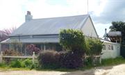
13 View St York
Lot 78
Simmonswood Cottage
York
Avon Arc
| Type | Status | Date | Documents |
|---|---|---|---|
| Heritage List | Adopted | 25 Nov 2019 |
| Type | Status | Date | Documents |
|---|---|---|---|
| (no listings) |
| Type | Status | Date | Grading/Management | |
|---|---|---|---|---|
| Category | ||||
| Local Heritage Survey | Adopted | 25 Nov 2019 | Grade B | |
Good; Authenticity and Integrity = Fair as per 2007 MI
Individual Building or Group
| Epoch | General | Specific |
|---|---|---|
| Present Use | RESIDENTIAL | Single storey residence |
This information is provided voluntarily as a public service. The information provided is made available in good faith and is derived from sources believed to be reliable and accurate. However, the information is provided solely on the basis that readers will be responsible for making their own assessment of the matters discussed herein and are advised to verify all relevant representations, statements and information.

Constructed from 1893
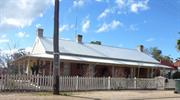
Residence, 13 View Street is significant for associations with Royal Marine Pensioner George Bagg, Samuel Craig who built and owned the Castle Hotel, and, William James who likely constructed the residence. It is a fine example of a stone residence in Victorian Georgian architectural style, into the beginning of the Federation period and makes a significant contribution to the history and historical townscape of York.
The residence is located at the top of a rise, sloping away on one side and to the rear. It is close to the road with a garden in the setback from the 1920s timber-framed decorative wire fence. The single storey face stone residence has a hipped roof. A bullnose veranda runs the entire perimeter of the residence with enclosures to the rear. The veranda is supported by square timber posts and criss-cross timber balustrades. The symmetrical frontage shows a central front door and double-hung windows flanking it, each with rendered surrounds. Tall painted brick corbelled chimneys are at the ends of the roof line.
York Suburban Lot P3 (4 acres) was surveyed in 1855, and granted to George Bagg in 1859 for his military service. He was a pensioner formerly a private in the Royal Marines. Samuel Craig purchased the property in 1861. Having arrived in the colony in 1851 with his wife Mary and children, it is claimed that he built and owned the Castle Hotel. After he died in 1869, his wife and family stayed until they subdivided into 11 lots in 1893, creating View Street at that time. Lot 5 was transferred to William James, a contractor, who is likely to have constructed the stone house. The Rate Book shows that in 1908 the residence was occupied by Walter John Wedgewood, a stonemason. In 1918, the George Boyle, a York farmer, purchased the property. In 1922 Michael Merrick as carrier from York purchased the property. In 1949 the Cassidy family who ran the night carts, bought the property and stayed for 42 years. It has changed hands a few times since then.
Integrity: High Authenticity: Moderate/High
Good
This information is provided voluntarily as a public service. The information provided is made available in good faith and is derived from sources believed to be reliable and accurate. However, the information is provided solely on the basis that readers will be responsible for making their own assessment of the matters discussed herein and are advised to verify all relevant representations, statements and information.
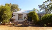
7 View St York
Lot 8
York
Avon Arc
| Type | Status | Date | Documents |
|---|---|---|---|
| Heritage List | Adopted | 25 Nov 2019 |
| Type | Status | Date | Documents |
|---|---|---|---|
| (no listings) |
| Type | Status | Date | Grading/Management | |
|---|---|---|---|---|
| Category | ||||
| Local Heritage Survey | Adopted | 25 Nov 2019 | Grade B | |
Good; Authenticity and Integrity = Fair as per 2007 MI
Individual Building or Group
| Epoch | General | Specific |
|---|---|---|
| Present Use | RESIDENTIAL | Single storey residence |
This information is provided voluntarily as a public service. The information provided is made available in good faith and is derived from sources believed to be reliable and accurate. However, the information is provided solely on the basis that readers will be responsible for making their own assessment of the matters discussed herein and are advised to verify all relevant representations, statements and information.

Constructed from 1913
Residence, 7 View Street is a good representative example of Federation Bungalow architectural style that makes a contribution to the historical townscape of York. It has historical interest for the association with the Baird family and the Avon Hairdressing Saloon in the 1940s.
The single storey masonry residence has a hipped roof with dominant half-timbered gable on the protruding frontage. A bullnose veranda returns across the remainder of the frontage and down one side that has been enclosed. The veranda posts have decorative angle brackets. The gable frontage features a pair of narrow vertical double-hung sash windows with an awning over, and the other front wall has a single double-hung sash window. The front door set has sidelights and a fanlight.
The rate books show that the site was vacant in 1910. The house in 1913 was owned by A Baird a hairdresser. A Baird was an active member of the York Athletic Club 1924-1926. In April 1946, a newspaper advertisement showed that J Baird (A.I.F.) was the proprietor of The Avon Hairdressing Saloon.
Integrity: High Authenticity: Moderate/High
Good
This information is provided voluntarily as a public service. The information provided is made available in good faith and is derived from sources believed to be reliable and accurate. However, the information is provided solely on the basis that readers will be responsible for making their own assessment of the matters discussed herein and are advised to verify all relevant representations, statements and information.
Water St cnr Spencers Brook Rd York
2 York Spencers Brook Road, York
York
Avon Arc
| Type | Status | Date | Documents |
|---|---|---|---|
| (no listings) |
| Type | Status | Date | Documents |
|---|---|---|---|
| (no listings) |
| Type | Status | Date | Grading/Management | |
|---|---|---|---|---|
| Category | ||||
| Local Heritage Survey | Adopted | 25 Nov 2019 | Grade C | |
Tree
| Epoch | General | Specific |
|---|---|---|
| Present Use | OTHER | Other |
| Original Use | OTHER | Other |
| General | Specific |
|---|---|
| OCCUPATIONS | Rural industry & market gardening |
This information is provided voluntarily as a public service. The information provided is made available in good faith and is derived from sources believed to be reliable and accurate. However, the information is provided solely on the basis that readers will be responsible for making their own assessment of the matters discussed herein and are advised to verify all relevant representations, statements and information.

The Almond tree possibly represents an association with an early settlement in that location.
The site contains an almond tree, which is believed to be over one hundred years old.
Integrity: High Authenticity: High
Good
This information is provided voluntarily as a public service. The information provided is made available in good faith and is derived from sources believed to be reliable and accurate. However, the information is provided solely on the basis that readers will be responsible for making their own assessment of the matters discussed herein and are advised to verify all relevant representations, statements and information.
1 Wheeler St York
Part of Blandstown Heritage Precinct
York
Avon Arc
| Type | Status | Date | Documents |
|---|---|---|---|
| (no listings) |
| Type | Status | Date | Documents |
|---|---|---|---|
| (no listings) |
| Type | Status | Date | Grading/Management | |
|---|---|---|---|---|
| Category | ||||
| Local Heritage Survey | Adopted | 25 Nov 2019 | Little/No Significance | |
Historic site
| Epoch | General | Specific |
|---|---|---|
| Original Use | COMMERCIAL | Other |
This information is provided voluntarily as a public service. The information provided is made available in good faith and is derived from sources believed to be reliable and accurate. However, the information is provided solely on the basis that readers will be responsible for making their own assessment of the matters discussed herein and are advised to verify all relevant representations, statements and information.
Constructed from 1967
02864 Blandstown Heritage Precinct
The Drive–in Theatre represents a cultural activity that came to York in the 1960s but was relatively short lived due to technology developments. Drive-ins traditionally engender memories for the enjoyment of that entertainment that is almost no longer practiced.
The expansive site is partially fenced, remnants of bitumen ramped rows, the remains of a timber framed and Asbestos clad entry ticket booth, and the timber framed and clad two storey concession and ablutions at ground floor and bio box above. The screen is not evident.
After York was opened for selection in 1830, the first settlers, arrived in 1831 from the Swan River settlement with the task of establishing a Government Farm. Balladong Farm was settled in 1831 by William Heal, later H. Bland after whom Blandstown is named. Stephen Stanley Parker had arrived in the Colony with his parents in 1830. After marrying Elizabeth Sewell in 1844 he purchased Balladong Farm in 1848. During the 1850s, Parker developed the property into a very successful farm. The “village” now known as Blandstown, the oldest privately settled part of the York town, developed around Balladong Farm due to the influential presence, water supply, and the river crossing. Wheeler Street area was developed in the 1860s when Robert Wheeler organised for five houses to be built in the street, opposite to where the drive-in was constructed 100 years later. It is not known what this site was used for in the intervening years.
Moderate/High
Fair
This information is provided voluntarily as a public service. The information provided is made available in good faith and is derived from sources believed to be reliable and accurate. However, the information is provided solely on the basis that readers will be responsible for making their own assessment of the matters discussed herein and are advised to verify all relevant representations, statements and information.
10 Wheeler St York
Part of Blandstown Heritage Precinct
York
Avon Arc
| Type | Status | Date | Documents |
|---|---|---|---|
| (no listings) |
| Type | Status | Date | Documents |
|---|---|---|---|
| (no listings) |
| Type | Status | Date | Grading/Management | |
|---|---|---|---|---|
| Category | ||||
| Local Heritage Survey | Adopted | 25 Nov 2019 | Considerable Significance | |
Individual Building or Group
| Epoch | General | Specific |
|---|---|---|
| Present Use | RESIDENTIAL | Single storey residence |
| Style |
|---|
| Victorian Georgian |
| Type | General | Specific |
|---|---|---|
| Wall | BRICK | Face Brick |
This information is provided voluntarily as a public service. The information provided is made available in good faith and is derived from sources believed to be reliable and accurate. However, the information is provided solely on the basis that readers will be responsible for making their own assessment of the matters discussed herein and are advised to verify all relevant representations, statements and information.
Constructed from 1860
02864 Blandstown Heritage Precinct
Cottage 10 Wheeler Street, is historically significant for the associations with Robert Wheeler who had 5 houses built; four for rental and his own at No 4, and the others at Nos, 2, 10, 12, and 14 Wheeler Street. Wansbrough who constructed the houses is of significance as a reputable builder and identity of the period. Whittler’s Cottage represents the 1860’s period and Wansbrough construction, demonstrating an early dwelling that makes a contribution to the historic townscapes of the Blandstown precinct, and of the town of York.
The single storey masonry residence has a pavilion gable roof with a separate front skillion veranda roof supported by slender round posts. The veranda extends across the addition. The original frontage was symmetrical with a central entry flanked by single–multi-paned windows. There is a low painted brick chimney at the west end.
After York was opened for selection in 1830, the first settlers, arrived in 1831 from the Swan River settlement with the task of establishing a Government Farm. Balladong Farm was settled in 1831 by William Heal, later H. Bland after whom Blandstown is named. Stephen Stanley Parker had arrived in the Colony with his parents in 1830. After marrying Elizabeth Sewell in 1844 he purchased Balladong Farm in 1848. During the 1850s, Parker developed the property into a very successful farm. The “village” now known as Blandstown, the oldest privately settled part of the York town, developed around Balladong Farm due to the influential presence, water supply, and the river crossing. In 1883 SS Parker sold one acre of locations u and v to Robert J Wheeler, a wheelwright, for 40 pounds. Robert Wheeler represents the enterprise of the early settlers in Blandstown having organised the construction of 5 houses in Wheeler Street in the 1860s. The Wheeler brothers built houses for themselves at Nos 2 and 4, and then cottages for their workers at Nos 10, 12, 14 Wheeler Street. Wheeler utilised the reputable building expertise of Wansbrough in partnership with Christie. In 1870, Wheeler Street was gazetted as a public roadway. It was called Hooley Street at that time and officially changed to Wheeler Street in c.1949.
Integrity: Moderate/High Authenticity: Moderate
Fair/Good
This information is provided voluntarily as a public service. The information provided is made available in good faith and is derived from sources believed to be reliable and accurate. However, the information is provided solely on the basis that readers will be responsible for making their own assessment of the matters discussed herein and are advised to verify all relevant representations, statements and information.
12 Wheeler St York
Part of Blandstown Heritage Precinct
Kitty-Paw
York
Avon Arc
Constructed from 1860
| Type | Status | Date | Documents |
|---|---|---|---|
| (no listings) |
| Type | Status | Date | Documents |
|---|---|---|---|
| (no listings) |
| Type | Status | Date | Grading/Management | |
|---|---|---|---|---|
| Category | ||||
| Local Heritage Survey | Adopted | 25 Nov 2019 | Considerable Significance | |
| Register of the National Estate | Registered | 21 Mar 1978 | ||
| Classified by the National Trust | Classified | 01 Apr 1985 | ||
| Register of the National Estate | Nominated | 21 Mar 1978 | ||
02864 Blandstown Heritage Precinct
Individual Building or Group
| Epoch | General | Specific |
|---|---|---|
| Original Use | RESIDENTIAL | Single storey residence |
| Present Use | RESIDENTIAL | Single storey residence |
| Style |
|---|
| Victorian Georgian |
| Type | General | Specific |
|---|---|---|
| Wall | BRICK | Painted Brick |
| Roof | METAL | Corrugated Iron |
This information is provided voluntarily as a public service. The information provided is made available in good faith and is derived from sources believed to be reliable and accurate. However, the information is provided solely on the basis that readers will be responsible for making their own assessment of the matters discussed herein and are advised to verify all relevant representations, statements and information.
Constructed from 1860
02864 Blandstown Heritage Precinct
Kitty Paw Cottage 12 Wheeler Street, is historically significant for the associations with Robert Wheeler who had 5 houses built; four for rental and his own at No 4, and the others at Nos, 2, 10, 12, and 14 Wheeler Street. Wansbrough who constructed the houses is of significance as a reputable builder and identity of the period. Kitty Paw Cottage retains its intact form and represents the 1860’s period and Wansbrough construction, demonstrating an early dwelling that makes a contribution to the historic townscapes of the Blandstown precinct, and of the town of York.
The single storey masonry residence has a pavilion gable roof with a separate front skillion veranda roof supported by square timber posts with simple decorative brackets. The frontage is symmetrical with a central entry flanked by single–multi-paned windows. A painted brick chimney at the west end is corbelled evident with double clay pots.
After York was opened for selection in 1830, the first settlers, arrived in 1831 from the Swan River settlement with the task of establishing a Government Farm. Balladong Farm was settled in 1831 by William Heal, later H. Bland after whom Blandstown is named. Stephen Stanley Parker had arrived in the Colony with his parents in 1830. After marrying Elizabeth Sewell in 1844 he purchased Balladong Farm in 1848. During the 1850s, Parker developed the property into a very successful farm. The “village” now known as Blandstown, the oldest privately settled part of the York town, developed around Balladong Farm due to the influential presence, water supply, and the river crossing. In 1883 SS Parker sold one acre of locations u and v to Robert J Wheeler, a wheelwright, for 40 pounds. Robert Wheeler represents the enterprise of the early settlers in Blandstown having organised the construction of 5 houses in Wheeler Street in the 1860s. The Wheeler brothers built houses for themselves at Nos 2 and 4, and then cottages for their workers at Nos 10, 12, 14 Wheeler Street. Wheeler utilised the reputable building expertise of Wansbrough in partnership with Christie. In 1870, Wheeler Street was gazetted as a public roadway. It was called Hooley Street at that time and officially changed to Wheeler Street in c.1949.
Integrity: Moderate/High Authenticity: Moderate/High
Fair/Good
| Ref ID No | Ref Name | Ref Source | Ref Date |
|---|---|---|---|
| "Blandstown Conservation Plan". |
This information is provided voluntarily as a public service. The information provided is made available in good faith and is derived from sources believed to be reliable and accurate. However, the information is provided solely on the basis that readers will be responsible for making their own assessment of the matters discussed herein and are advised to verify all relevant representations, statements and information.
14 Wheeler St York
Part of Blandstown Heritage Precinct
Eglantyne
York
Avon Arc
Constructed from 1870
| Type | Status | Date | Documents |
|---|---|---|---|
| (no listings) |
| Type | Status | Date | Documents |
|---|---|---|---|
| (no listings) |
| Type | Status | Date | Grading/Management | |
|---|---|---|---|---|
| Category | ||||
| Local Heritage Survey | Adopted | 25 Nov 2019 | Considerable Significance | |
| Register of the National Estate | Nominated | 21 Mar 1978 | ||
| Classified by the National Trust | Classified | 01 Apr 1985 | ||
| Register of the National Estate | Registered | 21 Mar 1978 | ||
02864 Blandstown Heritage Precinct
Individual Building or Group
| Epoch | General | Specific |
|---|---|---|
| Original Use | RESIDENTIAL | Single storey residence |
| Present Use | RESIDENTIAL | Single storey residence |
| Style |
|---|
| Victorian Georgian |
| Type | General | Specific |
|---|---|---|
| Roof | METAL | Corrugated Iron |
| Wall | BRICK | Painted Brick |
This information is provided voluntarily as a public service. The information provided is made available in good faith and is derived from sources believed to be reliable and accurate. However, the information is provided solely on the basis that readers will be responsible for making their own assessment of the matters discussed herein and are advised to verify all relevant representations, statements and information.
Constructed from 1860
02864 Blandstown Heritage Precinct
Eglantyne Cottage, 14 Wheeler Street, is historically significant for the associations with Robert Wheeler who had 5 houses built; four for rental and his own at No 4, and the others at Nos, 2, 10, 12, and 14 Wheeler Street. Wansbrough who constructed the houses is of significance as a reputable builder and identity of the period. Whittler’s Cottage represents the 1860’s period and Wansbrough construction, demonstrating an early dwelling that makes a contribution to the historic townscapes of the Blandstown precinct, and of the town of York.
The single storey masonry residence has a pavilion gable roof with a separate front skillion veranda roof supported by square timber posts. The frontage is symmetrical, except for veranda enclosure additions along the east side. The front has a central entry flanked by single –multi-paned windows. A low painted brick chimney at the west end has double clay pots.
After York was opened for selection in 1830, the first settlers, arrived in 1831 from the Swan River settlement with the task of establishing a Government Farm. Balladong Farm was settled in 1831 by William Heal, later H. Bland after whom Blandstown is named. Stephen Stanley Parker had arrived in the Colony with his parents in 1830. After marrying Elizabeth Sewell in 1844 he purchased Balladong Farm in 1848. During the 1850s, Parker developed the property into a very successful farm. The “village” now known as Blandstown, the oldest privately settled part of the York town, developed around Balladong Farm due to the influential presence, water supply, and the river crossing. In 1883 SS Parker sold one acre of locations u and v to Robert J Wheeler, a wheelwright, for 40 pounds. Robert Wheeler represents the enterprise of the early settlers in Blandstown having organised the construction of 5 houses in Wheeler Street in the 1860s. The Wheeler brothers built houses for themselves at Nos 2 and 4, and then cottages for their workers at Nos 10, 12, 14 Wheeler Street. Wheeler utilised the reputable building expertise of Wansbrough in partnership with Christie. In 1870, Wheeler Street was gazetted as a public roadway. It was called Hooley Street at that time and officially changed to Wheeler Street in c.1949.
Integrity: Moderate/High Authenticity: Moderate
Fair/Good
| Ref ID No | Ref Name | Ref Source | Ref Date |
|---|---|---|---|
| "Blandstown Conservation Plan". |
This information is provided voluntarily as a public service. The information provided is made available in good faith and is derived from sources believed to be reliable and accurate. However, the information is provided solely on the basis that readers will be responsible for making their own assessment of the matters discussed herein and are advised to verify all relevant representations, statements and information.
2,4,10 Wheeler St York
Part of Blandstown Heritage Precinct
Wheeler Brothers' Houses
York
Avon Arc
Constructed from 1870
| Type | Status | Date | Documents |
|---|---|---|---|
| (no listings) |
| Type | Status | Date | Documents |
|---|---|---|---|
| (no listings) |
| Type | Status | Date | Grading/Management | |
|---|---|---|---|---|
| Category | ||||
| Local Heritage Survey | Adopted | 25 Nov 2019 | Considerable Significance | |
02864 Blandstown Heritage Precinct
Individual Building or Group
| Epoch | General | Specific |
|---|---|---|
| Present Use | RESIDENTIAL | Single storey residence |
| Original Use | RESIDENTIAL | Single storey residence |
| Style |
|---|
| Victorian Georgian |
| Type | General | Specific |
|---|---|---|
| Wall | BRICK | Common Brick |
| Roof | METAL | Corrugated Iron |
This information is provided voluntarily as a public service. The information provided is made available in good faith and is derived from sources believed to be reliable and accurate. However, the information is provided solely on the basis that readers will be responsible for making their own assessment of the matters discussed herein and are advised to verify all relevant representations, statements and information.
Constructed from 1860, Constructed from 1865
02864 Blandstown Heritage Precinct
Whittler’s Cottage is historically significant for the associations with Robert Wheeler who had 5 houses built; four for rental and his own at No 4, and the others at Nos, 2, 10, 12, and 14 Wheeler Street. Wansbrough who constructed the houses is of significance as a reputable builder and identity of the period. Whittler’s Cottage represents the 1860’s period and Wansbrough construction, demonstrating an early dwelling that makes a contribution to the historic townscapes of the Blandstown precinct, and of the town of York.
The single storey cottage has a low-pitched hipped roof. The front verandah is a skillion extension of the main roof. The symmetrical cottage frontage evidences the original central entry and flanking multi-paned double hung windows recessed from the outside flanking additions. Each of the veranda additions is a room within the veranda space under the veranda roof and along the side of the cottage. The painted brick seems to be Colonial bond. Central on the front wall of each infill is a vertical slender 3-pane window opening. The splayed header detail on all the windows and the door opening is the same detail. No chimney is evident on the roof line.
After York was opened for selection in 1830, the first settlers, arrived in 1831 from the Swan River settlement with the task of establishing a Government Farm. Balladong Farm was settled in 1831 by William Heal, later H. Bland after whom Blandstown is named. Stephen Stanley Parker had arrived in the Colony with his parents in 1830. After marrying Elizabeth Sewell in 1844 he purchased Balladong Farm in 1848. During the 1850s, Parker developed the property into a successful farm. The “village” now known as Blandstown, the oldest privately settled part of the York town, developed around Balladong Farm due to the influential presence, water supply, and the river crossing. In 1883 SS Parker sold one acre of locations u and v to Robert J Wheeler, a wheelwright, for 40 pounds. Robert Wheeler represents the enterprise of the early settlers in Blandstown having organised the construction of 5 houses in Wheeler Street in the 1860s. The Wheeler brothers built houses for themselves at Nos 2 and 4, and then cottages for their workers at Nos 10, 12, 14 Wheeler Street. Wheeler utilised the reputable building expertise of Wansbrough in partnership with Christie. No.2 is more substantial than the workers cottages, for one of the Wheeler brothers. In 1870, Wheeler Street was gazetted as a public roadway. It was called Hooley Street at that time and officially changed to Wheeler Street in c.1949.
Integrity: Moderate/High Authenticity: Moderate/High
Fair/Good
| Ref ID No | Ref Name | Ref Source | Ref Date |
|---|---|---|---|
| "Blandstown Conservation Plan". |
This information is provided voluntarily as a public service. The information provided is made available in good faith and is derived from sources believed to be reliable and accurate. However, the information is provided solely on the basis that readers will be responsible for making their own assessment of the matters discussed herein and are advised to verify all relevant representations, statements and information.
4 Wheeler St York
York
Avon Arc
| Type | Status | Date | Documents |
|---|---|---|---|
| (no listings) |
| Type | Status | Date | Documents |
|---|---|---|---|
| (no listings) |
| Type | Status | Date | Grading/Management | |
|---|---|---|---|---|
| Category | ||||
| (no listings) | ||||
Precinct or Streetscape
| Epoch | General | Specific |
|---|---|---|
| Present Use | RESIDENTIAL | Single storey residence |
| Style |
|---|
| Victorian Georgian |
This information is provided voluntarily as a public service. The information provided is made available in good faith and is derived from sources believed to be reliable and accurate. However, the information is provided solely on the basis that readers will be responsible for making their own assessment of the matters discussed herein and are advised to verify all relevant representations, statements and information.
8 Wheeler St York
Part of Blandstown Heritage Precinct
York
Avon Arc
| Type | Status | Date | Documents |
|---|---|---|---|
| (no listings) |
| Type | Status | Date | Documents |
|---|---|---|---|
| (no listings) |
| Type | Status | Date | Grading/Management | |
|---|---|---|---|---|
| Category | ||||
| Local Heritage Survey | Adopted | 25 Nov 2019 | Some Significance | |
Individual Building or Group
| Style |
|---|
| Federation Bungalow |
| Type | General | Specific |
|---|---|---|
| Wall | TIMBER | Weatherboard |
This information is provided voluntarily as a public service. The information provided is made available in good faith and is derived from sources believed to be reliable and accurate. However, the information is provided solely on the basis that readers will be responsible for making their own assessment of the matters discussed herein and are advised to verify all relevant representations, statements and information.
Constructed from 1925
02864 Blandstown Heritage Precinct
Residence, 8 Wheeler Street is historically significant as together with the similar residence at No 16 Wheeler Street, it represents one of the few developments in the twentieth century workers cottages in Blandstown, that makes a contribution to the historic townscapes of the Blandstown precinct, and of the town of York.
The single storey timber framed house is elevated on stumps. The predominantly hipped roof has a half timbered gable detail on the protruding half front with a veranda on the recessed half. The weatherboard cladding is to dado height with flat sheet fibrocement cladding above. The windows are single double-hung sashes in timber frames.
After York was opened for selection in 1830, the first settlers, arrived in 1831 from the Swan River settlement with the task of establishing a Government Farm. Balladong Farm was settled in 1831 by William Heal, later H. Bland after whom Blandstown is named. Stephen Stanley Parker had arrived in the Colony with his parents in 1830. After marrying Elizabeth Sewell in 1844 he purchased Balladong Farm in 1848. During the 1850s, Parker developed the property into a very successful farm. The “village” now known as Blandstown, the oldest privately settled part of the York town, developed around Balladong Farm due to the influential presence, water supply, and the river crossing. Robert Wheeler represents the enterprise of the early settlers in Blandstown having organised the construction of 5 houses in Wheeler Street in the 1860s, at No’s 2, 4, 10, 12, and 14. Later infills in the 1920s are timber framed workers cottages at No’s 8 and 16 Wheeler Street. In 1870, Wheeler Street was gazetted as a public roadway. It was called Hooley Street at that time and officially changed to Wheeler Street in c.1949.
Moderate/High
Good
This information is provided voluntarily as a public service. The information provided is made available in good faith and is derived from sources believed to be reliable and accurate. However, the information is provided solely on the basis that readers will be responsible for making their own assessment of the matters discussed herein and are advised to verify all relevant representations, statements and information.
16 Wheeler Street York
Part of Blandstown Heritage Precinct
York
Avon Arc
| Type | Status | Date | Documents |
|---|---|---|---|
| (no listings) |
| Type | Status | Date | Documents |
|---|---|---|---|
| (no listings) |
| Type | Status | Date | Grading/Management | |
|---|---|---|---|---|
| Category | ||||
| Local Heritage Survey | Adopted | 25 Nov 2019 | Some Significance | |
Individual Building or Group
| Epoch | General | Specific |
|---|---|---|
| Present Use | RESIDENTIAL | Single storey residence |
| Style |
|---|
| Federation Bungalow |
| Type | General | Specific |
|---|---|---|
| Roof | METAL | Corrugated Iron |
This information is provided voluntarily as a public service. The information provided is made available in good faith and is derived from sources believed to be reliable and accurate. However, the information is provided solely on the basis that readers will be responsible for making their own assessment of the matters discussed herein and are advised to verify all relevant representations, statements and information.
Constructed from 1925
02864 Blandstown Heritage Precinct
Residence, 16 Wheeler Street is historically significant as together with the similar residence at No 8 Wheeler Street, it represents one of the few developments in the twentieth century workers cottages in Blandstown, that makes a contribution to the historic townscapes of the Blandstown precinct, and of the town of York.
The single storey timber framed house is elevated on stumps. The predominantly hipped roof has a half-timbered gable detail on the protruding half front with a veranda on the recessed half. The weatherboard cladding is to dado height with flat sheet fibrocement cladding above. The windows are single double-hung sashes in timber frames. Decorative geometric brackets support the square timber veranda posts at the entry
After York was opened for selection in 1830, the first settlers, arrived in 1831 from the Swan River settlement with the task of establishing a Government Farm. Balladong Farm was settled in 1831 by William Heal, later H. Bland after whom Blandstown is named. Stephen Stanley Parker had arrived in the Colony with his parents in 1830. After marrying Elizabeth Sewell in 1844 he purchased Balladong Farm in 1848. During the 1850s, Parker developed the property into a very successful farm. The “village” now known as Blandstown, the oldest privately settled part of the York town, developed around Balladong Farm due to the influential presence, water supply, and the river crossing. Robert Wheeler represents the enterprise of the early settlers in Blandstown having organised the construction of 5 houses in Wheeler Street in the 1860s, at No’s 2, 4, 10, 12, and 14. Later infills in the 1920s are timber framed workers cottages at No’s 8 and 16 Wheeler Street. In 1870, Wheeler Street was gazetted as a public roadway. It was called Hooley Street at that time and officially changed to Wheeler Street in c.1949.
Moderate/High
Good
This information is provided voluntarily as a public service. The information provided is made available in good faith and is derived from sources believed to be reliable and accurate. However, the information is provided solely on the basis that readers will be responsible for making their own assessment of the matters discussed herein and are advised to verify all relevant representations, statements and information.
4 Wheeler Street York
Part of Blandstown Heritage Precinct
York
Avon Arc
| Type | Status | Date | Documents |
|---|---|---|---|
| (no listings) |
| Type | Status | Date | Documents |
|---|---|---|---|
| (no listings) |
| Type | Status | Date | Grading/Management | |
|---|---|---|---|---|
| Category | ||||
| Local Heritage Survey | Adopted | 25 Nov 2019 | Considerable Significance | |
Individual Building or Group
This information is provided voluntarily as a public service. The information provided is made available in good faith and is derived from sources believed to be reliable and accurate. However, the information is provided solely on the basis that readers will be responsible for making their own assessment of the matters discussed herein and are advised to verify all relevant representations, statements and information.
Constructed from 1860
02864 Blandstown Heritage Precinct
Wheeler’s Residence (fmr), 4 Wheeler Street, is historically significant for the direct associations with Robert Wheeler who had 5 houses built; four for rental and his own at No 4, and the others at Nos, 2, 10, 12, and 14 Wheeler Street. Wansbrough who constructed the houses is of significance as a reputable builder and identity of the period. Wheeler’s Residence (fmr) represents the 1860’s period and Wansbrough construction, demonstrating an early dwelling that makes a contribution to the historic townscapes of the Blandstown precinct, and of the town of York.
The single storey masonry residence is detailed in reverse tone Flemish bond. It has an expansive frontage with a central entry and two rooms each side, each with a single double-hung sash window (not original). There is evidence that the outer two rooms (one each side) were later additions, although also in the same brick detail. The front veranda roof that returns along the west side, is separate from the main pavilion gable roof. Three face brick corbelled chimneys are evident along the ridgeline.
After York was opened for selection in 1830, the first settlers, arrived in 1831 from the Swan River settlement with the task of establishing a Government Farm. Balladong Farm was settled in 1831 by William Heal, later H. Bland after whom Blandstown is named. Stephen Stanley Parker had arrived in the Colony with his parents in 1830. After marrying Elizabeth Sewell in 1844 he purchased Balladong Farm in 1848. During the 1850s, Parker developed the property into a very successful farm. The “village” now known as Blandstown, the oldest privately settled part of the York town, developed around Balladong Farm due to the influential presence, water supply, and the river crossing. In 1883 SS Parker sold one acre of locations u and v to Robert J Wheeler, a wheelwright, for 40 pounds. Robert Wheeler represents the enterprise of the early settlers in Blandstown having organised the construction of 5 houses in Wheeler Street in the 1860s. The Wheeler brothers built houses for themselves at Nos 2 and 4, and then cottages for their workers at Nos 10, 12, 14 Wheeler Street. Wheeler utilised the reputable building expertise of Wansbrough in partnership with Christie. No.4 is more substantial than the workers cottages, for one of the Wheeler brothers. In 1870, Wheeler Street was gazetted as a public roadway. It was called Hooley Street at that time and officially changed to Wheeler Street in c.1949.
Moderate/High
Good
This information is provided voluntarily as a public service. The information provided is made available in good faith and is derived from sources believed to be reliable and accurate. However, the information is provided solely on the basis that readers will be responsible for making their own assessment of the matters discussed herein and are advised to verify all relevant representations, statements and information.
13-15 William St York
Part of Blandstown Heritage Precinct
York
Avon Arc
Constructed from 1885
| Type | Status | Date | Documents |
|---|---|---|---|
| (no listings) |
| Type | Status | Date | Documents |
|---|---|---|---|
| (no listings) |
| Type | Status | Date | Grading/Management | |
|---|---|---|---|---|
| Category | ||||
| Local Heritage Survey | Adopted | 25 Nov 2019 | Some Significance | |
02864 Blandstown Heritage Precinct
Individual Building or Group
| Epoch | General | Specific |
|---|---|---|
| Present Use | RESIDENTIAL | Single storey residence |
| Original Use | RESIDENTIAL | Single storey residence |
| Style |
|---|
| Victorian Georgian |
| Type | General | Specific |
|---|---|---|
| Wall | BRICK | Common Brick |
| Roof | METAL | Corrugated Iron |
| General | Specific |
|---|---|
| DEMOGRAPHIC SETTLEMENT & MOBILITY | Workers {incl. Aboriginal, convict} |
This information is provided voluntarily as a public service. The information provided is made available in good faith and is derived from sources believed to be reliable and accurate. However, the information is provided solely on the basis that readers will be responsible for making their own assessment of the matters discussed herein and are advised to verify all relevant representations, statements and information.
Constructed from 1895
02864 Blandstown Heritage Precinct
Crossing Cottage is historically significant for its associations with the 1895 railway and its close proximity to the crossing over Great Southern Highway. It demonstrates a way of life for a railway worker, managing the crossing, and is an example of a Victorian Georgian architectural style that typifies a worker’s cottage, and contributes to the historic townscapes of the Blandstown precinct, and of the town of York.
The single storey residence has a simple hipped roof. It is presents a symmetrical frontage with a central door flanked by single double-hung sash windows with rendered surrounds. The front veranda has been removed.
After York was opened for selection in 1830, the first settlers, arrived in 1831 from the Swan River settlement with the task of establishing a Government Farm. Balladong Farm was settled in 1831 by William Heal, later H. Bland after whom Blandstown is named. Stephen Stanley Parker had arrived in the Colony with his parents in 1830. After marrying Elizabeth Sewell in 1844 he purchased Balladong Farm in 1848. During the 1850s, Parker developed the property into a very successful farm. The “village” now known as Blandstown, the oldest privately settled part of the York town, developed around Balladong Farm due to the influential presence, water supply, and the river crossing. William Street area developed with the advent of the railway line in 1895, and this cottage was a worker’s cottage associated with that era of development. The cottage was constructed for a railway worker and his family. Located in close proximity to the railway line crossing over Great Southern Highway, it was his task to open close the gates to the crossing when trains came through to prevent road traffic at that time. Although located in Blandstown its history is associated with the development of the railway rather than that of Blandstown. The place was condemned in 2010 when it lost the roof in a storm. The roof has since been replaced.
Integrity: Moderate/High Authenticity: Moderate/High
Fair
| Ref ID No | Ref Name | Ref Source | Ref Date |
|---|---|---|---|
| "Blandstown Conservation Plan". |
This information is provided voluntarily as a public service. The information provided is made available in good faith and is derived from sources believed to be reliable and accurate. However, the information is provided solely on the basis that readers will be responsible for making their own assessment of the matters discussed herein and are advised to verify all relevant representations, statements and information.