Local Government
Bayswater
Region
Metropolitan
Garratt Rd Bayswater
Additional addresses: Garratt Rd, Ascot & Grandstand Rd, Ascot H.37 at SLKm 0.12m Map 2, UF3
and Down stream (1972); MRWA 950
Garratt Road Bridges Upstream (1935)
Bayswater
Metropolitan
Constructed from 1972, Constructed from 1935
| Type | Status | Date | Documents |
|---|---|---|---|
| Heritage List | Adopted | 25 Feb 2020 | |
| State Register | Registered | 23 Mar 2010 | HCWebsite.Listing+ListingDocument, HCWebsite.Listing+ListingDocument |
| Type | Status | Date | Documents |
|---|---|---|---|
| (no listings) |
| Type | Status | Date | Grading/Management | |
|---|---|---|---|---|
| Category | ||||
| Classified by the National Trust | Classified | 14 Apr 1998 | ||
| Statewide Lge Timber Str Survey | Completed | 11 Dec 1998 | ||
| Local Heritage Survey | Adopted | 25 Feb 2020 | Classification 1 | |
| Municipal Inventory | Adopted | 24 Feb 1998 | Classification 3 | |
Garratt Road Bridge is in good condition and shows evidence of ongoing maintenance and repairs. It has high integrity and authenticity.
| Name | Type | Year From | Year To |
|---|---|---|---|
| Ernie Godfrey | Architect | 1933 | 1935 |
| Main Roads of Western Australia (MRWA) | Architect | 1933 | 1972 |
| Library Id | Title | Medium | Year Of Publication |
|---|---|---|---|
| 9530 | Swan and Helena rivers regional recreational path development plan. | Report | 2009 |
| 11995 | Report : Maintenance of Timber Bridges in the Metropolitian region. | Heritage Study {Other} | 2021 |
| 9531 | Swan and Helena rivers management framework: heritage audit and statement of significance, final report 26 February 2009. | Heritage Study {Other} | 2009 |
Other Built Type
| Epoch | General | Specific |
|---|---|---|
| Original Use | Transport\Communications | Road: Bridge |
| Present Use | Transport\Communications | Road: Bridge |
| Type | General | Specific |
|---|---|---|
| Other | TIMBER | Other Timber |
| General | Specific |
|---|---|
| TRANSPORT & COMMUNICATIONS | Technology & technological change |
| SOCIAL & CIVIC ACTIVITIES | Sport, recreation & entertainment |
| TRANSPORT & COMMUNICATIONS | Road transport |
| OUTSIDE INFLUENCES | Water, power, major t'port routes |
| DEMOGRAPHIC SETTLEMENT & MOBILITY | Workers {incl. Aboriginal, convict} |
| OUTSIDE INFLUENCES | Depression & boom |
This information is provided voluntarily as a public service. The information provided is made available in good faith and is derived from sources believed to be reliable and accurate. However, the information is provided solely on the basis that readers will be responsible for making their own assessment of the matters discussed herein and are advised to verify all relevant representations, statements and information.
Constructed from 1935 to 1970
The first bridge was built to cater to the motor car age, but at a time when the volume of traffic was not large, and thus is a demonstration of a way of life. However, it was not essentially the car which brought about the perceived need for the bridge. Belmont and Bayswater had been agitating since 1898 for a bridge between them. The bridge also has historical significance as the result of a very long running campaign in both Bayswater and Belmont. The idea of a bridge was taken up by the Town Planning Commission in the late 1920s, the intended site being at Slade Street. However, the Tonkin Highway which crosses the River upstream has since reduced the overall importance of Garratt Road Bridge. The bridge also has environmental significance, as it greatly altered the local human and physical environment by brining Bayswater and Belmont together and providing an additional river crossing between Perth and Guildford. It also made Garratt Road an important artery in the district, as formerly it had been of little consequence. Finally, the bridge has social significance as the availability of a link between the two sides of the river meant that there was a flow of people across the river for work and commuting to Perth. It also attracted people to the riverside at Garratt Road which developed into the major riverside recreation area in the district and remained so until the early 1970s.
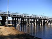
The Garratt Road Bridge comprises two separate road bridges separated by a bridge width, with the upstream one (Bridge 950) being used for southbound traffic as well as a foot bridge, and the downstream one (Bridge 952) being used for traffic travelling north. The upper bridge also carries two pipes with large diameters on its outer edges. Both bridges are supported by timber piles driven into the river bed, linked with timber cross bracing and double beams top and bottom, then spanned by timber logs, which in turn support the wooden decking. The upper bridge, which is somewhat lower in height, has steel R. S. J. beams replacing the original upper linking wooden beams. The railing to both roadways is of steel safety variety, although the foot bridge retains the white painted wooden railing that was originally used throughout. The 1935 bridge comprises 38 spans and is 237.89 metres in length. The width between kerbs is 8.38m. Round timber stringers and driven piles have been used. It was built as 37/20ft and 1/40ft, with 20ft width between kerbs and a 50ft footway.
The Garratt Road Bridge is part of an important artery which links the City of Bayswater with the City of Belmont, providing an important route to the Perth Airport. The structure has held a significant place in the history of metropolitan Perth long before it was built, as the idea of a bridge over the Swan River was an issue of concern to residents on either side of the river from the late 1890s. It was perhaps the subject of more deputations than any other issue in the district. The campaign for a bridge gathered momentum when the new Town Planning Commission took up the issue just before the Depression, strongly advocating the route which brings Slade Street, Bayswater as the possible site. Depression conditions frustrated this work along with many others, and when the idea was finally endorsed by the Main Roads Department the site had shifted to Garratt Road. Garratt Road thus went from a sidetrack to a major artery and in this process, some houses had to be demolished or shifted, including Wright's fishing business which was directly in the path of the bridge. This was on of the houses to be moved. The bridge was opened on New Years Day 1935 and by the mid-1950s the traffic flow across the river had outgrown the bridge, and it was widened in 1962 to 27ft 6in between kerbs. In 1970 it was duplicated with another bridge 7 yards downstream. The 1935 now goes from Bayswater to Belmont, while the 1970 bridge goes in the opposite direction.
This information is provided voluntarily as a public service. The information provided is made available in good faith and is derived from sources believed to be reliable and accurate. However, the information is provided solely on the basis that readers will be responsible for making their own assessment of the matters discussed herein and are advised to verify all relevant representations, statements and information.
Constructed from 1935
The place is a landmark on the Swan River and is a good example of timber bridges built by the Main Roads Department. The place is the longest remaining timber bridge with a steel navigation span in the state. The construction of a bridge at this point in the river was long compaigned for by the local community; prior to its erection residents has to cross the river at Bassendean or the Causeway.
Two separate road bridges, the upstream one being used for south-bound traffic as well as a foot bridge and the downstream one for traffic travelling north. The upstream 1935 bridge also carries two large diameter pipes on it's outer edges. Both bridges are supported by timber piles driven into the river bed linked with timber cross bracing and double beams top and bottom and then spanned by timber logs which in turn support the wooden decking. The 1935 bridge, which is somewhat lower in height, has steel R.S.J. beams replacing the original upper linking wooden beams. The railing to both roadways has steel safety rails, although the foot bridge retains the white painted wooden railing that was originally used throughout. The 1935 bridge is supported by about 37 piers and 38 spans over a length of 238 meters. Roadworks to the bridge are classified as a 'public work' and are permitted without the need for Council approval.
The Garratt Road Bridge was significant in Bayswater history long before it was built, as the idea of a bridge over the Swan River was an issue of concern to Bayswater from the late 1880s. It was perhaps the subject of more deputations than any other issue in the district. The campaign for a bridge gathered momentum when the new Town Planning Commission (established in 1928) took up the issue just before the Depression, strongly advocating Slade Street as the site. Depression conditions frustrated this work along with many others, and when the idea was finally endorsed by the Main Roads Department the site had shifted to Garratt Road. Garratt Road thus went from a sidetrack to a major artery and in this process, some houses had to be demolished or shifted, including Wright's fishing business which was directly in the path of the bridge. The bridge was opened on New Year's Day 1935 and by the mid 1950s the traffic flow across the river had outgrown the bridge. The bridge was widened in 1962 to allow for increased traffic flow both ways, and in 1970 a duplicate bridge was built adjacent (downstream). In 1972, a reinforced concrete overlay was installed with fabric expansion joints at every third pier. Further work was carried out in 1989, including the replacement of the concrete overlay and of the original karri halfcaps. The 1935 bridge now goes from Bayswater to Belmont, while the 1970 bridge goes in the opposite direction.
Integrity - High Authenticity - High
Good
| Ref Number | Description |
|---|---|
| 32 | Local Heritage Survey Number |
This information is provided voluntarily as a public service. The information provided is made available in good faith and is derived from sources believed to be reliable and accurate. However, the information is provided solely on the basis that readers will be responsible for making their own assessment of the matters discussed herein and are advised to verify all relevant representations, statements and information.
114 King William St Bayswater
Bayswater Historical Society
Leighton
Bayswater
Metropolitan
Constructed from 1893
| Type | Status | Date | Documents |
|---|---|---|---|
| Heritage List | Adopted | 25 Feb 2020 | |
| State Register | Registered | 23 Jun 2000 | HCWebsite.Listing+ListingDocument, HCWebsite.Listing+ListingDocument |
| Type | Status | Date | Documents |
|---|---|---|---|
| (no listings) |
| Type | Status | Date | Grading/Management | |
|---|---|---|---|---|
| Category | ||||
| Classified by the National Trust | YES | 02 Mar 1982 | ||
| Register of the National Estate | Nominated | 30 Apr 1982 | ||
| Register of the National Estate | Indicative Place | |||
| Classified by the National Trust | Classified | 02 Mar 1982 | ||
| Municipal Inventory | Adopted | 24 Feb 1998 | Classification 1 | |
| Local Heritage Survey | Adopted | 25 Feb 2020 | Classification 1 | |
| Name | Type | Year From | Year To |
|---|---|---|---|
| H T Halliday | Architect | - | - |
| Library Id | Title | Medium | Year Of Publication |
|---|---|---|---|
| 7196 | Conservation plan for colonial sites on the City of Bayswater foreshore. CONFIDENTIAL | Heritage Study {Cons'n Plan} | 2004 |
Individual Building or Group
| Epoch | General | Specific |
|---|---|---|
| Present Use | EDUCATIONAL | Museum |
| Original Use | RESIDENTIAL | Single storey residence |
| Style |
|---|
| Federation Queen Anne |
| Type | General | Specific |
|---|---|---|
| Roof | METAL | Corrugated Iron |
| Wall | BRICK | Common Brick |
| General | Specific |
|---|---|
| DEMOGRAPHIC SETTLEMENT & MOBILITY | Settlements |
This information is provided voluntarily as a public service. The information provided is made available in good faith and is derived from sources believed to be reliable and accurate. However, the information is provided solely on the basis that readers will be responsible for making their own assessment of the matters discussed herein and are advised to verify all relevant representations, statements and information.
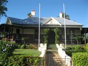
A large stately house externally, retaining the architectural character of the period and association with the one family and with the local council in its early days.
A single story house, originally built in the 1880s and added to over a period of time to form a large family homogeneous house in fairly typical style for the period, constructed of brickwork with corrugated iron roof and with prominent chimneys and a wide encircling verandah.
Part of the original house was used by the Bayswater Road Board for their early meetings and the ownership of the house has remained in the one family, the builder of the house, Mr H. T. Halliday, being the first chairman of the Road Board.
Externally, the building as a whole is intact except for new roof sheeting and rafters to the verandahs being altered to some extent, but generally in keeping with the rest of the house.
This information is provided voluntarily as a public service. The information provided is made available in good faith and is derived from sources believed to be reliable and accurate. However, the information is provided solely on the basis that readers will be responsible for making their own assessment of the matters discussed herein and are advised to verify all relevant representations, statements and information.
Constructed from 1892
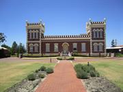
This place is significant for its association with the Halliday family, who were influential to the development of Bayswater. It is a representative example of the Federation Queen Anne architectural style. This landmark building has important social and cultural associations, which continues today through its use by the Bayswater Historical Society.
Halliday House is a large well constructed brick house with a double hipped roof over a summetrical square plan and with a small, half timbered gable and ventilator over the central front entrance. A separate low pitched iron roof supported on full length timber posts extends across the front verandahs from the corner bay and continues down the right hand (northern) side verandah. The external brick walls are tuck-pointed up to the mid-level of the double hung sash windows with cement render above this height and on the window sills. The roof is crowed at the ridge corners with prominent brick chimneys each with two terracotta pots and there is a flight of six cement steps up to the entrance from the central cement pathway though a well kept and extensively formal garden. Halliday House is an unusually elaborate residence for this area. The interior includes a decorative niched oval dome housing the chandelier and ornate masonry in the passageways. The front boundary is marked by a decorative wrought iron fence and gate decorated with a clipped hedge.
The land on which "Leighton" is built was originally acquired from James Alexander Halliday by Henry Halliday in 1894. However, it would appear that Halliday started building the house in 1892 and, with his wife Edith, took up residence in 1893. During the early 1890s, a small settlement on the Bayswater estate was growing and the Hallidays, though not one of the first land purchasers of 1885, were part of this development. Thus, the house has a connection with the pioneering phase of Bayswater. Most houses in the 1880s and 1890s were hastily built from corrugated iron but "Leighton House" was constructed in a much more substantial manner. One of the most elaborate houses in the district, it reflects not only the Halliday's resources, but also their faith in the future of Bayswater. It was a 'dream home' of the time. It is also significant as a self built house of an early master builder. The Bapitist congregation was inaugurated at "Leighton" in 1895. Those in attendance included the Halliday family and four others. Until the building of a Baptist Church, it no doubt continued to provide a meeting place for the small congregation. In recent years, the house has been restored and was transferred to the Bayswater Historical Society who maintain the house as a museum and headquarters of the historical society.
Integrity - High Authenticity - High
Good
| Ref Number | Description |
|---|---|
| 56 | Local Heritage Survey Number |
This information is provided voluntarily as a public service. The information provided is made available in good faith and is derived from sources believed to be reliable and accurate. However, the information is provided solely on the basis that readers will be responsible for making their own assessment of the matters discussed herein and are advised to verify all relevant representations, statements and information.
150 Guildford Rd Maylands
Constable Care Child Safety Foundation
School of Instrumental Music
Bayswater
Metropolitan
Constructed from 1903 to 1920
| Type | Status | Date | Documents |
|---|---|---|---|
| Heritage List | Adopted | 25 Feb 2020 | |
| State Register | Registered | 23 Jan 2004 | HCWebsite.Listing+ListingDocument, HCWebsite.Listing+ListingDocument |
| Type | Status | Date | Documents |
|---|---|---|---|
| (no listings) |
| Type | Status | Date | Grading/Management | |
|---|---|---|---|---|
| Category | ||||
| Municipal Inventory | Adopted | 17 Jun 1997 | Classification 1 | |
| Local Heritage Survey | Adopted | 25 Feb 2020 | Classification 1 | |
Maylands Primary School, a complex of single storey brick and iron buildings and timber and iron buildings, in Federation Free and Federation Arts and Craft style, comprising of a Senior Primary School (1903), Shelter Shed (1905), Junior Primary School (1915), Out of School Care Centre and an Arts and Crafts Centre (1920),
| Name | Type | Year From | Year To |
|---|---|---|---|
| Hillson Beasley | Architect | - | - |
| Library Id | Title | Medium | Year Of Publication |
|---|---|---|---|
| 6943 | Maylands Primary School, 150 Guildford Road, Maylands : conservation plan. | Heritage Study {Cons'n Plan} | 2004 |
| 9226 | Senior toilet block at Maylands Primary School (fmr): Photographic archival record. | Archival Record | 2008 |
| 9796 | Maylands Primary School (fmr) toilet block: photographic archival record. | Archival Record | 2011 |
Individual Building or Group
| Epoch | General | Specific |
|---|---|---|
| Original Use | EDUCATIONAL | Primary School |
| Present Use | EDUCATIONAL | Other |
| Style |
|---|
| Federation Free Style |
| Federation Arts and Crafts |
| Type | General | Specific |
|---|---|---|
| Roof | METAL | Corrugated Iron |
| Wall | RENDER | Smooth |
| Wall | BRICK | Common Brick |
| Other | TIMBER | Other Timber |
| General | Specific |
|---|---|
| SOCIAL & CIVIC ACTIVITIES | Education & science |
| SOCIAL & CIVIC ACTIVITIES | Institutions |
This information is provided voluntarily as a public service. The information provided is made available in good faith and is derived from sources believed to be reliable and accurate. However, the information is provided solely on the basis that readers will be responsible for making their own assessment of the matters discussed herein and are advised to verify all relevant representations, statements and information.
Constructed from 1903
Maylands Primary School is an example of a school designed and built by the Public Works Department of Western Australia in the early decades of the twentieth century and a fine example of the Federation Free and Federation Arts and Crafts style. It has historic importance for its educational and civic associations.
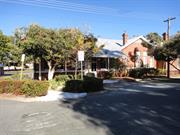
Maylands Primary School is a complex of single storey brick and iron buildings and timber and iron buildings, in Federation Free and Federation Arts and Crafts style, which was built as the school progressed. The school is situated on the corner of Guildford Road and Peninsula Road, with Sixth Avenue dividing the School into the Senior Primary and the Junior Primary. Sixth Avenue has been closed at the junction to Guildford Road to form the school car park. An overhead pedestrian bridge connects the school site to the other side of Sixth Avenue. The Senior Primary (south western side) comprises the Senior Primary School (1903), an Arts and Crafts Centre (1920), a Shelter Shed (1905), two Toilet Blocks and a Storage Shed. The north eastern side of the school is devoted to the Junior Primary, comprising of the Junior Primary School (1915), an Out of School Care Centre, a Shelter Shed, a Gardener's Shed and a storage shed, as well as a demountable kindergarten. The Senior Primary School is a Federation Freestyle brick and iron building, with tuck pointed red brick to all elevations with a corrugated iron gable roof and brick corbelled cap chimneys. The exterior details of the building feature rendered stringcourse at sill height and rendered sills to window openings. The Senior Primary School houses four classrooms, a Common Room, the Library, the Administration and Reception, the School Hall, Toilets, Canteen and two stores. The building is essentially U-shaped in plan with the Hall at the centre of the building and rooms surrounding it. The Arts and Crafts Centre is a timber framed building with a corrugated iron gable roof, with a rectangular plan. It features full height timber weatherboard to all walls, with a skillion to its northwest side that is the darkroom / storeroom. The Shelter Shed is of timber construction with full height weatherboard walls, with the exception of its southeast elevation that is open, and a double gable iron roof. The Junior Primary School is a brick and timber building exhibiting a Federation and Arts and Crafts influence. The Junior School building is a tuck-pointed red brick and stone building with a corrugated iron half hipped, half gable roof with brick and rendered corbelled cap chimneys. Essentially a rectangular building with an enclosed verandah to the rear, the building houses six classrooms, a Wet Area, a Music Room, an ESL Room, Toilets, an Interview Room and two Storerooms. Recent buildings on the site including the brick Gardener's Sheds, Toilet Blocks, the metal Storage Shed and the Kindergarten Demountable are of little significance. A more detailed description of the Maylands Primary School can be found in the Interim Entry Report for the State Register of Heritage Places prepared by the Heritage Council of WA.
Maylands Primary School was built by the Public Works Department over a number of years under the guidance of Assistant Architect Hillson Beasley, who later went on to become the Chief Architect (1906-1916). Due to a rapid increase in the local population in Maylands between 1901 and 1903, the Maylands School opened in 1903 with a single classroom on a site bounded by Guildford Road, Peninsula Road and Sixth Avenue. That same year, plans were drawn by the Public Works Department for an addition comprising two more classrooms and an extended verandah on the north of the building. With the construction of these additions by 1904, further plans were drawn in the same year for an infants class room adjoining the north-east of the existing structure and for the existing verandah on the north of the existing classrooms to be enclosed for a corridor. The buildings were then further extended in 1905 to include a two classroom wing, teachers' quarter, hat / cloakroom and washing / latrine facilities and shelter sheds. Further extensions then occurred in 1909 and 1912. The design of the Maylands school was typical for its time, generally following a standard plan, that when fully realised, consisted of a central hall around which class rooms were built. This type of design is one for which the architect, Hillson Beasley, is particularly noted. This model allowed for new classrooms to be added as the need arose. The Maylands School was typical in that the hall was not part of the original construction but rather was added in 1909, a few years after the provision of the initial classrooms in 1903. This would indicate that there was a rapidly growing school age population in the Maylands area that required almost a continuous building of educational facilities. During the period of the War, a separate Infants' School was built on a site across from the existing school on Sixth Avenue in 1915. The design of this building was influenced by the educational philosophy of Italian doctor, Maria Montessori, with 20 feet wide verandahs on to which classrooms opened, and special light furniture, which provided opportunities for flexible and open air teaching. As part of the continuing development of centres for technical training in Western Australian schools, in 1920 a Manual Training Room was built for a Perth Junior Technical School on the Peninsula Road side of the Maylands Primary School site. This was to serve the needs of senior primary school boys from schools in the surrounding area. In 1978, this building was converted to a new arts and crafts centre.
Integrity - High Authenticity - High
Good
| Name | Type | Year From | Year To |
|---|---|---|---|
| PWD Hillson Beasley | Architect | 1903 | - |
| Ref Number | Description |
|---|---|
| 164 | Local Heritage Survey Number |
| Owner | Category |
|---|---|
| Education Department | State Gov't |
This information is provided voluntarily as a public service. The information provided is made available in good faith and is derived from sources believed to be reliable and accurate. However, the information is provided solely on the basis that readers will be responsible for making their own assessment of the matters discussed herein and are advised to verify all relevant representations, statements and information.
196 Guildford Rd Maylands
Bayswater
Metropolitan
Constructed from 1908 to 1992
| Type | Status | Date | Documents |
|---|---|---|---|
| Heritage List | Adopted | 25 Feb 2020 | |
| State Register | Registered | 23 Jan 2009 | HCWebsite.Listing+ListingDocument, HCWebsite.Listing+ListingDocument |
| Type | Status | Date | Documents |
|---|---|---|---|
| (no listings) |
| Type | Status | Date | Grading/Management | |
|---|---|---|---|---|
| Category | ||||
| Local Heritage Survey | Adopted | 25 Feb 2020 | Classification 2 | |
| Municipal Inventory | Adopted | 17 Jun 1997 | Classification 1 | |
Maylands Police Station and Quarters is in good condition as a result of ongoing use and maintenance. Externally, the building is in fair to good condition and is well maintained.
| Library Id | Title | Medium | Year Of Publication |
|---|---|---|---|
| 8837 | Maylands Police Station and quarters (fmr). Guildford Road, Maylands. | Heritage Study {Cons'n Plan} | 2008 |
Individual Building or Group
| Epoch | General | Specific |
|---|---|---|
| Present Use | GOVERNMENTAL | Police Station or Quarters |
| Original Use | GOVERNMENTAL | Police Station or Quarters |
| Style |
|---|
| Federation Queen Anne |
| Type | General | Specific |
|---|---|---|
| Other | TIMBER | Other Timber |
| Wall | BRICK | Other Brick |
| Roof | METAL | Corrugated Iron |
| General | Specific |
|---|---|
| DEMOGRAPHIC SETTLEMENT & MOBILITY | Depression & boom |
| SOCIAL & CIVIC ACTIVITIES | Law & order |
This information is provided voluntarily as a public service. The information provided is made available in good faith and is derived from sources believed to be reliable and accurate. However, the information is provided solely on the basis that readers will be responsible for making their own assessment of the matters discussed herein and are advised to verify all relevant representations, statements and information.
Constructed from 1908
The place has significance as an early suburban police station, is representative of the development of the Maylands townsite and is a landmark feature along Guildford Road.
A single storey police station with integral quarters, each with separate entries. The entrance of the police station is emphasized by a portico with a stucco decorated gable. It has load bearing brick, tuck pointed, and an iron roof with stucco dressings and decorations.
An architecturally pleasing building with a high standard of design in the utilitarian movement. The place is an example of an early suburban police station and quarters, clearly intended for a metropolitan service.
Integrity - High Authenticity - High
Good
| Ref Number | Description |
|---|---|
| 171 | Local Heritage Survey Number |
This information is provided voluntarily as a public service. The information provided is made available in good faith and is derived from sources believed to be reliable and accurate. However, the information is provided solely on the basis that readers will be responsible for making their own assessment of the matters discussed herein and are advised to verify all relevant representations, statements and information.
86 Guildford Rd Maylands
15/12/2011 Address includes: 1, 3 & 3A Thirlmere Rd, Mount Lawley. VFL. ALSO CONTAINS PLACE NUMBER 16303 AND ASSOCIATED WITH REGISTERED PLACE NUMBER 669
Bayswater
Metropolitan
Constructed from 1919
| Type | Status | Date | Documents |
|---|---|---|---|
| Heritage List | Adopted | 25 Feb 2020 | |
| State Register | Registered | 01 Jul 1994 | HCWebsite.Listing+ListingDocument |
| Type | Status | Date | Documents |
|---|---|---|---|
| (no listings) |
| Type | Status | Date | Grading/Management | |
|---|---|---|---|---|
| Category | ||||
| Classified by the National Trust | YES | |||
| Classified by the National Trust | Classified | 07 Mar 1989 | ||
| Register of the National Estate | Permanent | 28 Sep 1982 | ||
| Municipal Inventory | Adopted | 17 Jun 1997 | Classification 1 | |
| Local Heritage Survey | Adopted | 25 Feb 2020 | Classification 1 | |
| Name | Type | Year From | Year To |
|---|---|---|---|
| Alexander Cameron of Wright, Powell & Cameron | Architect | - | - |
| Albany, Bell Ltd. | Architect | - | - |
| Library Id | Title | Medium | Year Of Publication |
|---|---|---|---|
| 127 | Albany Bell Castle property : conservation plan. | Heritage Study {Cons'n Plan} | 1992 |
| 9531 | Swan and Helena rivers management framework: heritage audit and statement of significance, final report 26 February 2009. | Heritage Study {Other} | 2009 |
| 9530 | Swan and Helena rivers regional recreational path development plan. | Report | 2009 |
Individual Building or Group
| Epoch | General | Specific |
|---|---|---|
| Present Use | INDUSTRIAL\MANUFACTURING | Other |
| Original Use | INDUSTRIAL\MANUFACTURING | Other |
| Style |
|---|
| Federation Romanesque |
| Type | General | Specific |
|---|---|---|
| Wall | BRICK | Common Brick |
This information is provided voluntarily as a public service. The information provided is made available in good faith and is derived from sources believed to be reliable and accurate. However, the information is provided solely on the basis that readers will be responsible for making their own assessment of the matters discussed herein and are advised to verify all relevant representations, statements and information.
Constructed from 1914 to 1919
The building is unique in the use of 'Medieval Caste' style to its single/double storey form. For its time, it was a large development, one of the first in its area on the fringe of Perth's developing suburbs.
Set in formal gardens, the building is a combination of single and double storey, possessing two square towers to its north (street) elevation and a castellated parapet giving it a castle-like appearance. The windows are double hung and on the first floor are a narrow Gothic style. The windows to the ground floor are a mix of arch or part arch with doors being the timber vertical boarded type. The building has extensive stucco work to its parapet frieze, quoins and major openings. The two towers possess small minaret style features at their corners.
The building was constructed in 1914-19 by J Hawkins and Sons to the design of Mr Aleck Cameron. It was originally built for Albany Bell as a store/warehouse/factory to service the chain of 13 tearooms in Perth, Coolgardie and Kalgoorlie.
The building is in very good condition and well maintained.
| Name | Type | Year From | Year To |
|---|---|---|---|
| Aleck Cameron | Architect | - | - |
This information is provided voluntarily as a public service. The information provided is made available in good faith and is derived from sources believed to be reliable and accurate. However, the information is provided solely on the basis that readers will be responsible for making their own assessment of the matters discussed herein and are advised to verify all relevant representations, statements and information.
Constructed from 1919, Constructed from 1914
This place is representative of the commercial development of the region, providing an unusual and attractive example of a factory setting. It has a historic association with Peter Albany Bell and the Bell family, who were influential members of the community. The site is a significant landmark feature along Guildford Road.
The place is set well back into its landscape and is a prominent landmark building. It is a building that takes a simple functional use and clads it in an elaborately detailed decorative skins of red brick and rendered embellishments in the form of castellations, quoins, battlements and prominent corner towers.
The building has a strong association with Mr Albany Bell, an important manufacturer and philanthropist in the early years of the 20th century, when Western Australia lagged behind the other States in developing urban industries. The Albany Bell Castle was built for Mr Alabny Bell's company and was designed by Mr Alexander Cameron of Wright Powell and Cameron. It is understood that the builder was J Hawkins and Sons. The Albany Bell Castle was originally constructed as a factory supplying cakes and confectionery to Bell's chains of tearooms located in Perth, Fremantle, Kalgoorlie and Coolgardie. The idea behind the design of the factory was to give employees the nice surroundings in which they would work instead of the terrible industrial housing that had developed in England. The factory itself was built in two stages. The first stage of two wing buildings was built in 1914. The north wing was a single storey bakehouse with an oven projecting from it and fireboxes in the cellar below. The south wing was double storey, the ground floor housing freezer rooms. The second stage was completed in 1919, it being the central block built across the front of the two existing wings. Mr Albany Bell sold his interest in the business in 1928 and since this time the place has had successive owners and uses. It has been a chicken hatchery, a reserve building for WA Newspapers in case its St George's Tce premises were bombed during the war, and offices of the Department of Transport. In addition, several editions of the daily news were printed there. In more recent years, the building has been gutted and redeveloped for residential apartments. This redevelopment ensured that the façade of the building remained intact, maintaining the integrity and authenticity of the external building.
The integrity and authenticity of the exterior is high, however given the many changes in use of the interiors and the redevelopment associated with these changes, the integrity and authenticity of the interior is low.
Good
| Name | Type | Year From | Year To |
|---|---|---|---|
| Mr Alexander Cameron of Wright Powell and Cameron. | Architect | 1914 | - |
| Ref Number | Description |
|---|---|
| 281 | Local Heritage Survey Number |
This information is provided voluntarily as a public service. The information provided is made available in good faith and is derived from sources believed to be reliable and accurate. However, the information is provided solely on the basis that readers will be responsible for making their own assessment of the matters discussed herein and are advised to verify all relevant representations, statements and information.
88-90 Guildford Rd Maylands
includes Swan River wetalnds behind the street blocks PART OF REGISTERED PLACES 669 and 2429 This place is also part of P11016 Maylands Peninsula
Pineapple Inn
The Pines
Bayswater
Metropolitan
Constructed from 1840
| Type | Status | Date | Documents |
|---|---|---|---|
| (no listings) |
| Type | Status | Date | Documents |
|---|---|---|---|
| (no listings) |
| Type | Status | Date | Grading/Management | |
|---|---|---|---|---|
| Category | ||||
| (no listings) | ||||
02429 Albany Bell Castle
Historic Site
| Epoch | General | Specific |
|---|---|---|
| Original Use | FARMING\PASTORAL | Homestead |
| Present Use | VACANT\UNUSED | Vacant\Unused |
| Type | General | Specific |
|---|---|---|
| Wall | EARTH | Adobe {Mud Brick} |
This information is provided voluntarily as a public service. The information provided is made available in good faith and is derived from sources believed to be reliable and accurate. However, the information is provided solely on the basis that readers will be responsible for making their own assessment of the matters discussed herein and are advised to verify all relevant representations, statements and information.
Nr cnr of Johnson & Hardey Rds Maylands
situated at Tranby House. Group of 2 REGISTERED AS PART OF 2411
Bayswater
Metropolitan
| Type | Status | Date | Documents |
|---|---|---|---|
| (no listings) |
| Type | Status | Date | Documents |
|---|---|---|---|
| (no listings) |
| Type | Status | Date | Grading/Management | |
|---|---|---|---|---|
| Category | ||||
| Classified by the National Trust | Classified {Trees} | |||
02411 Tranby House
| Library Id | Title | Medium | Year Of Publication |
|---|---|---|---|
| 6607 | Register of significant trees as at June 1988. | Report | 1988 |
| 7196 | Conservation plan for colonial sites on the City of Bayswater foreshore. CONFIDENTIAL | Heritage Study {Cons'n Plan} | 2004 |
Tree
| Epoch | General | Specific |
|---|---|---|
| Present Use | OTHER | Other |
| Original Use | OTHER | Other |
This information is provided voluntarily as a public service. The information provided is made available in good faith and is derived from sources believed to be reliable and accurate. However, the information is provided solely on the basis that readers will be responsible for making their own assessment of the matters discussed herein and are advised to verify all relevant representations, statements and information.
2C Johnson Rd Maylands
near Cnr Johnson & Hardey Rds
Bayswater
Metropolitan
Constructed from 1836
| Type | Status | Date | Documents |
|---|---|---|---|
| Heritage List | Adopted | 25 Feb 2020 | |
| State Register | Registered | 20 Oct 1995 | HCWebsite.Listing+ListingDocument, HCWebsite.Listing+ListingDocument |
| Type | Status | Date | Documents |
|---|---|---|---|
| (no listings) |
| Type | Status | Date | Grading/Management | |
|---|---|---|---|---|
| Category | ||||
| Register of the National Estate | Registered | 21 Mar 1978 | ||
| Classified by the National Trust | Classified | 16 Dec 1976 | ||
| Register of the National Estate | Nominated | 21 Mar 1978 | ||
| Local Heritage Survey | Adopted | 25 Feb 2020 | Classification 1 | |
| Municipal Inventory | Adopted | 17 Jun 1997 | Classification 1 | |
| Library Id | Title | Medium | Year Of Publication |
|---|---|---|---|
| 9530 | Swan and Helena rivers regional recreational path development plan. | Report | 2009 |
| 6384 | Tranby House. | Heritage Study {Other} | 0 |
| 1630 | Tranby House, Peninsula Farm, Maylands : conservation report. | Heritage Study {Other} | 1992 |
| 8065 | A chain of care : a history of the Silver Chain Nursing Association 1905 - 2005. | Book | 2005 |
| 12052 | Peninsula Farm (Tranby) Maylands | Heritage Study {Cons'n Plan} | 2005 |
| 9531 | Swan and Helena rivers management framework: heritage audit and statement of significance, final report 26 February 2009. | Heritage Study {Other} | 2009 |
| 7196 | Conservation plan for colonial sites on the City of Bayswater foreshore. CONFIDENTIAL | Heritage Study {Cons'n Plan} | 2004 |
| 6040 | Investigating Tranby House : a teacher resource book and student workbook. | Heritage Study {Other} | 1996 |
| 2188 | Conservation master plan for Tranby House Grounds, Maylands Peninsula, Western Australia. | Heritage Study {Other} | 1990 |
Individual Building or Group
| Epoch | General | Specific |
|---|---|---|
| Present Use | EDUCATIONAL | Museum |
| Original Use | RESIDENTIAL | Single storey residence |
| Style |
|---|
| Vernacular |
| Type | General | Specific |
|---|---|---|
| Wall | BRICK | Common Brick |
| Roof | TILE | Other Tile |
| General | Specific |
|---|---|
| DEMOGRAPHIC SETTLEMENT & MOBILITY | Land allocation & subdivision |
This information is provided voluntarily as a public service. The information provided is made available in good faith and is derived from sources believed to be reliable and accurate. However, the information is provided solely on the basis that readers will be responsible for making their own assessment of the matters discussed herein and are advised to verify all relevant representations, statements and information.
Constructed from 1836
This site is representative of the early settlement of the Maylands Peninsula and is one of the oldest surviving residences in the Perth Metropolitan Region. It is significant for its associations with the Hardey family, who were influential to the development of the Maylands Peninsula. This site is highly valued by the local and broader community and contributes greatly to the understanding of the cultural history of Perth.
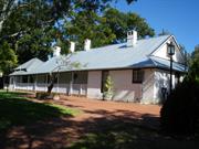
A group of single storey farm buildings comprising an Old Colonial Georgian farm house style, store and cellar building in a fine landscape setting of mature trees and cottage garden. Tranby House is a single storey farmhouse with a long, low gable running eastwest with a break-pitch verandah all around. It is built in the Old Colonial Georgian style. The verandah is partly open on the south, forms a porch on the east, is closed in along the north and on the west meets a skillion roof from the separate lock of the dry store and cellar building. This block has its own hipped roof and lean-to verandahs. The composition is punctuated by unusual arch-hood chimneys. The house is built of brick walls which are plastered inside and features original hand cut rafters and flooring. It has a simple plan form, with principal rooms accessed off the verandah. Sleeping accommodation is provided in the attics approached by internal staircases. The main roof structure is of timber rafters, purlins and collar-ties, some of which have been re-engineered. Although there are some rafters and purlins that are probably of an early date, it is not clear if they are original or in the original position. The main walls of the house are locally produced orange clay bricks, set in lime mortar, rendered and painted. On the south, the walls have been rendered and ruled. On the east, the walls of the porch are bagged and painted. Restoration works occurred on the house throughout the 70s and 80s, and the feed store and stable were demolished, as they were not considered significant and were in poor condition.
Tranby House is one of the earliest surviving residences in the inner metropolitan area and is closely associated with the earliest phases of rural development along the Swan River. The place has a close association with the Hardey family, farming pioneers who were influential in the religious, business and political life of the Swan River colony, Joseph Hardey in particular. Tranby House is named after the ship that brought these settlers to Western Australia. The first Methodists came to Western Australia in February 1830, aboard the ship Tranby, to found a small religious community in the newly established Swan River Colony. Led by brothers John and Joseph Hardey, the group included a surgeon, preacher, bricklayers, blacksmith, shoemaker, surveyor, hatter, midshipman and several farmers. They were granted, upon arrival, land on a peninsula four miles upstream from Perth, where the present Perth suburb of Maylands is situated. The group were amongst the first European residents of the area and the buildings they constructed some of the first in the colony. Tranby House was established as the residence of Joseph Hardey and his family. There is some doubt as to the actual date of Tranby House, but it appears to have been the third house built by the Hardeys on the site. Initially, the Hardeys established a property and built a wattle and daub house with a thatched roof in 1830. Floods in the area of the house forced them to rebuild and in 1836, the family moved to York for two years where they established another farm. In 1838, Joseph Hardey recorded in his diary that he had purchased bricks and wood for a new house and by June 1839 had recorded that the roof was being finished. It seems likely that this is the current house and, if so, would be one of the oldest brick houses in the State. Tranby House is a rare example of a colonial farm house and the setting of the place is enhanced by the retention of public open space nearby. The trees that survive from the early landscape (oaks, olives, mulberries) also contribute to the understanding of that period of development. Tranby House is the oldest extant residence in the district and is highly valued by the general community as a place of historic and social significance. It contributes to the community's sense of place by providing a link with the colonial development of the area.
Integrity - High Authenticity - High
Good
| Ref Number | Description |
|---|---|
| 182 | Local Heritage Survey Number |
This information is provided voluntarily as a public service. The information provided is made available in good faith and is derived from sources believed to be reliable and accurate. However, the information is provided solely on the basis that readers will be responsible for making their own assessment of the matters discussed herein and are advised to verify all relevant representations, statements and information.
219-221 Railway Pde Maylands
Peninsula Community Centre
Bayswater
Metropolitan
Constructed from 1906
| Type | Status | Date | Documents |
|---|---|---|---|
| Heritage List | Adopted | 25 Feb 2020 | |
| State Register | Registered | 23 Sep 1994 | HCWebsite.Listing+ListingDocument, HCWebsite.Listing+ListingDocument |
| Type | Status | Date | Documents |
|---|---|---|---|
| (no listings) |
| Type | Status | Date | Grading/Management | |
|---|---|---|---|---|
| Category | ||||
| Register of the National Estate | Permanent | 21 Mar 1978 | ||
| Statewide Hotel Survey | Completed | 01 Nov 1997 | ||
| Classified by the National Trust | Classified | 16 Sep 1974 | ||
| Local Heritage Survey | Adopted | 25 Feb 2020 | Classification 1 | |
| Municipal Inventory | Adopted | 17 Jun 1997 | Classification 1 | |
| Library Id | Title | Medium | Year Of Publication |
|---|---|---|---|
| 9676 | Peninsula Community Centre: 1906 - 1996. | Brochure | 1996 |
| 1915 | Peninsula Hotel, Maylands, Western Australia : study of the building and environs for the City of Stirling. | Heritage Study {Other} | 1975 |
| 5551 | Five graves in Dalwallinu : a life of Wilhelm Gustave Liebe. | Book | 1991 |
| 522 | Peninsula Community Centre (formerly the Peninsula Hotel) Conservation Plan for the Peninsula Association Inc | Heritage Study {Cons'n Plan} | 1994 |
| 291 | Restoration work carried out at the Peninsula Building, Railway Parade, Maylands, Western Australia. | Heritage Study {Other} | 1987 |
| 1916 | Restoration work carried out at the Peninsula Building, Railway Parade, Maylands, Western Australia. | Heritage Study {Other} | 1985 |
Individual Building or Group
| Epoch | General | Specific |
|---|---|---|
| Original Use | COMMERCIAL | Hotel, Tavern or Inn |
| Present Use | VACANT\UNUSED | Vacant\Unused |
| Style |
|---|
| Other Style |
| Type | General | Specific |
|---|---|---|
| Roof | TILE | Ceramic Tile |
| Wall | BRICK | Common Brick |
| General | Specific |
|---|---|
| OCCUPATIONS | Hospitality industry & tourism |
This information is provided voluntarily as a public service. The information provided is made available in good faith and is derived from sources believed to be reliable and accurate. However, the information is provided solely on the basis that readers will be responsible for making their own assessment of the matters discussed herein and are advised to verify all relevant representations, statements and information.
Constructed from 1906
The place is significant for its association with the development of the Maylands townsite. It has a special association with Wilhelm Friederich Gustave Liebe, the building contractor, who has worked on a number of prominent buildings throughout Perth. It has social and cultural significance, both as a Hotel and being that it was one of the first buildings in Perth to be saved as a result of public campaigning.
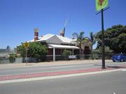
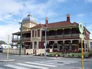
The hotel is a fine Edwardian style structure of two storeys with a corner tower crowned by a cupola. The two street facades feature deep verandahs supported on Metters cast iron posts and balustrades of lace. Much of the interior is authentic, though some parts are missing. It has cavity tuck pointed brickwork, timber double hung sash windows and a clay tile roof. The cupola in the corner tower is zinc clad. It has fine mosiac tiles, stained glass windows and a plaster vault over the main stair.
The Peninsula Hotel forms part of the Maylands Town centre. The building demonstrates the early expansion of Maylands as a residential suburb, which followed the establishment of the Ferguson factory and the railway station. The building was constructed and owned by Wilhelm Friederich Gustave Liebe, a well known Perth Building contractor. The site was chosen to take full advantage of the benefits of being located directly opposite the railway station. Liebe and his partner Joseph Klein moved from Melbourne to Western Australia in 1891, at which time this long standing partnership dissolved due to Klein's illhealth. In Perth, Liebe worked with leading architects on a number of large and grandiose projects, including Queen's Hall (1899), His Majesty's Theatre (1904), the Public Art Gallery (1908), several banks and a number of stations for the Midland Railway Company of Western Australia. Liebe specialised in hotel construction, with the Peninsula Hotel, which he owned, being of partcular note. The Peninsula Hotel has played a prominent role in the social life of the Maylands community. While the declaration of war on Germany in August 1914 saw the hotel doors closed, after WWI the hotel continued as a centre of social activity. During the 1920s and early 1930s, the hotel was the start and finish line for the Beverley to Perth Cycle Race, inaugurated by Mr Percy Armstrong. However, by the 1970s demand for suburban hotel accommodation had declined, Australian drinking habits were changing and the Peninsula Hotel was in need of repairs and updating. In 1973, the Swan Brewery decided to build a tavern on an adjacent site and proposed demolishing the Peninsula Hotel to provide a car park. The building's high degree of social value was clearly demonstrated at this time, with the local community and the National Trust of Australia making significant efforts to prevent its demolition in the 1970s. After a well attended public meeting in July 1974, the brewery agreed to a "stay of execution" and influenced by this change in attitude, the National Trust classified the building. It was the intention of the Peninsula Association, a group formed independently by people interested in conserving the old hotel building, to restore the building to a condition in which community groups would be able to use the hotel as a focus for social activities and community development. This has been achieved, with the building currently being used by a variety of community groups as a base for their organisation. It is one of the earliest historic places to be saved through public outcry. The building is a rare example of a richly detailed Edwardian Hotel, still largely in its original form, in metropolitan Perth.
Integrity - High Authenticity - High
Overall condition is fair to good, though maintenance and restoration programs are ongoing.
| Ref Number | Description |
|---|---|
| 207 | Local Heritage Survey Number |
This information is provided voluntarily as a public service. The information provided is made available in good faith and is derived from sources believed to be reliable and accurate. However, the information is provided solely on the basis that readers will be responsible for making their own assessment of the matters discussed herein and are advised to verify all relevant representations, statements and information.
21 Swan Bank Rd Maylands
Address also includes: 1 Clarkson Road, Maylands
WA Police Academy & Reserve
WA Police Department Transport Section
Bayswater
Metropolitan
Constructed from 1923 to 1963
| Type | Status | Date | Documents |
|---|---|---|---|
| Heritage List | Adopted | 25 Feb 2020 | |
| Heritage Agreement | YES | 01 Sep 2021 | HCWebsite.Listing+ListingDocument |
| State Register | Registered | 02 Sep 1998 | HCWebsite.Listing+ListingDocument, HCWebsite.Listing+ListingDocument |
| Type | Status | Date | Documents |
|---|---|---|---|
| (no listings) |
| Type | Status | Date | Grading/Management | |
|---|---|---|---|---|
| Category | ||||
| Municipal Inventory | Adopted | 17 Jun 1997 | Classification 1 | |
| Local Heritage Survey | Adopted | 25 Feb 2020 | Classification 1 | |
| Classified by the National Trust | YES | 10 May 1999 | ||
| Register of the National Estate | Indicative Place | |||
| Statewide Lge Timber Str Survey | Completed | 11 Dec 1998 | ||
| Classified by the National Trust | Classified | 14 Jun 1999 | ||
| Name | Type | Year From | Year To |
|---|---|---|---|
| WA Police Acadmey | Architect | - | - |
| Library Id | Title | Medium | Year Of Publication |
|---|---|---|---|
| 9531 | Swan and Helena rivers management framework: heritage audit and statement of significance, final report 26 February 2009. | Heritage Study {Other} | 2009 |
| 9530 | Swan and Helena rivers regional recreational path development plan. | Report | 2009 |
| 3340 | W A Police Reserve Maylands Peninsula 1995 Conservation Plan | Heritage Study {Cons'n Plan} | 1995 |
Individual Building or Group
| Epoch | General | Specific |
|---|---|---|
| Present Use | GOVERNMENTAL | Office or Administration Bldg |
| Original Use | Transport\Communications | Air: Other |
| Style |
|---|
| Other Style |
| Type | General | Specific |
|---|---|---|
| Wall | METAL | Corrugated Iron |
| Wall | TIMBER | Weatherboard |
| General | Specific |
|---|---|
| PEOPLE | Famous & infamous people |
| TRANSPORT & COMMUNICATIONS | Air transport |
| OCCUPATIONS | Commercial & service industries |
This information is provided voluntarily as a public service. The information provided is made available in good faith and is derived from sources believed to be reliable and accurate. However, the information is provided solely on the basis that readers will be responsible for making their own assessment of the matters discussed herein and are advised to verify all relevant representations, statements and information.
Constructed from 1923
This site has a very high level of significance, being the first aerodrome in Perth and the site where airplanes were first manufactured. This site is representative of the evolution of transport and communication facilities within Western Australia. It has historic associations for the record breaking flights that occurred in the 1920s.
All buildings that serviced the aerodrome remain, though the runways are not in evidence. Most buildings have been adapted for police use and some new buildings have been added. A variety of buildings including aircraft hangers and other ancillary buildings in wide variety of construction types and materials relating to both the aerodrome period and of police use. It consists primarily of a group of brick, steel and timber framed, corrugated iron and timber clad airfield and police buildings.
The place, which commenced operation in 1924, was the birthplace of commercial aviation in Western Australia. It was the first permanent aerodrome in Perth and functioned as its principle aerodrome throughout the 1920s, 1930s and the first half of the 1940s. The place was important in improving transport and communications between Western Australia, the eastern States and overseas. The place is also important for its association with the pioneering record-breaking long-distance flights which were a feature of aviation in the 1920s and early 1930s. The first successful production of airplanes in Western Australia occurred at this place in the mid-1920s and during WWII, when the aerodrome facilities were utilised for the reconstruction and repair of airframes and aircraft engines, with a considerable civilian workforce being employed on site. It contributed significantly to the war effort during WWII and continued to be an important facility for general aviation activities until its closure in 1963. The place formed part of a national civil and defence aviation network and was part of the imperial and interstate air mail service. The place is associated with the initial colonial settlement of the peninsula in 1830 by the group of Weslayan settlers who arrived in the "Tranby". The place is especially associated with the original grantees of the land - Joseph Hardey, and Michael and James Smith Clarkson, who were all prominent citizens in the social and commercial life of the colony. The place is also associated with the Royal Australian Air Force, which used the place during the inter-war years and with the Royal Aero Club of Western Australia, a central force in aviation education and publicity.
Integrity - Low Authenticity - Moderate
Condition of structures with heritage significance is generally good, though all structures are in need of conservation and maintenance
| Ref Number | Description |
|---|---|
| 232 | Local Heritage Survey Number |
| Owner | Category |
|---|---|
| WA Police | State Gov't |
This information is provided voluntarily as a public service. The information provided is made available in good faith and is derived from sources believed to be reliable and accurate. However, the information is provided solely on the basis that readers will be responsible for making their own assessment of the matters discussed herein and are advised to verify all relevant representations, statements and information.
Constructed from 1923 to 1942
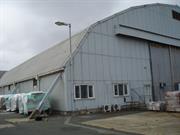
The hangar buildings at Maylands have aesthetic value as a highly visible landmark throughout much of the area, as well as being able to be clearly seen from several office buildings in the centre of Perth. The hangar area at Maylands is also highly significant because of its association with the beginnings of air transport in Western Australia and Australia. It was the terminal for the most important air mail service in Australia from 1929 to 1934 and was the key link in the air services between Western Australia and the eastern states as well as internal air services from 1924 to 1963. It was also Western Australia's first major aerodrome and is thus the only one of its kind in the State and one of only six inter-war capital city aerodromes in Australia.
The precinct comprises a steel-framed hangar construction in 1929, a timber hangar constructed in 1934 with wartime extensions, a 1934 caretaker's brick house, a 1930s brick administration building, a c.1942 timber hangar with asbestos roof and several minor buildings.
Land on the Maylands Peninsula was assigned to settlers from the Tranby in February 1830. This land was subsequently subdivided. In 1923 the Commonwealth government acquired 130 acres for a new aerodrome for Perth and subsequently further small areas of land were added to the aerodrome. The building in the south-east corner of the aerodrome was developed between 1924 and 1942 in response to developments in aviation. In 1924 Maylands was the southern terminus for Norman Brearley's north-west air service, Australia's first commercial airline service. In 1929 Maylands became the western terminus for Australia's first trans-continental air service. In 1934 Maylands became the Western Australia terminus for the first imperial air mail service from Britain. Maylands also became a centre for Western Australian aviation. During World War Two Maylands became a major centre for military aviation. Maylands was closed as an aerodrome in mid-1963 and subsequently a section of about 25 acres, including the building area, was taken over by the Western Australia Police Department for multiple use, including the construction of a police academy, stables and other buildings. A large part of the aerodrome landing area has now been converted into a golf course with the fairways named after famous aviators.
The roof of the 1929 hangar has been replaced but this has not significantly affected the fabric of the building. Alterations to the 1942 building for police use are largely internal and could be removed with ease.
All the buildings remain in relatively good physical condition. The asbestos roof of the 1942 hangar requires attention.
This information is provided voluntarily as a public service. The information provided is made available in good faith and is derived from sources believed to be reliable and accurate. However, the information is provided solely on the basis that readers will be responsible for making their own assessment of the matters discussed herein and are advised to verify all relevant representations, statements and information.
22 Swan Bank Rd Maylands
Bayswater
Metropolitan
Constructed from 1927
| Type | Status | Date | Documents |
|---|---|---|---|
| Heritage List | Adopted | 25 Feb 2020 | |
| State Register | Registered | 09 Feb 1996 | HCWebsite.Listing+ListingDocument, HCWebsite.Listing+ListingDocument |
| Type | Status | Date | Documents |
|---|---|---|---|
| (no listings) |
| Type | Status | Date | Grading/Management | |
|---|---|---|---|---|
| Category | ||||
| Classified by the National Trust | YES | 18 Aug 1985 | ||
| Register of the National Estate | Indicative Place | |||
| Classified by the National Trust | Classified | 12 Dec 1985 | ||
| Register of the National Estate | Nominated | 09 Aug 1988 | ||
| Local Heritage Survey | Adopted | 25 Feb 2020 | Classification 1 | |
| Municipal Inventory | Adopted | 17 Jun 1997 | Classification 1 | |
| Library Id | Title | Medium | Year Of Publication |
|---|---|---|---|
| 124 | Maylands Brickworks : preservation and restoration study. | Book | 1984 |
| 9088 | History of the Metropolitan Brick Holdings Pty Ltd. | Journal article | 1977 |
| 7196 | Conservation plan for colonial sites on the City of Bayswater foreshore. CONFIDENTIAL | Heritage Study {Cons'n Plan} | 2004 |
| 3851 | Archaeological Survey and Assessment of the South Clay Pit, Maylands Brickworks. | Heritage Study {Other} | 1999 |
| 10261 | Maylands Brickworks: conservation management plan | Heritage Study {Cons'n Plan} | 2013 |
| 251 | Maylands Brickworks : conservation and management plan. | Heritage Study {Cons'n Plan} | 1990 |
| 9530 | Swan and Helena rivers regional recreational path development plan. | Report | 2009 |
| 9531 | Swan and Helena rivers management framework: heritage audit and statement of significance, final report 26 February 2009. | Heritage Study {Other} | 2009 |
Individual Building or Group
| Epoch | General | Specific |
|---|---|---|
| Present Use | VACANT\UNUSED | Vacant\Unused |
| Original Use | INDUSTRIAL\MANUFACTURING | Brickworks |
| Style |
|---|
| Other Style |
| Type | General | Specific |
|---|---|---|
| Wall | BRICK | Common Brick |
| General | Specific |
|---|---|
| PEOPLE | Innovators |
| OCCUPATIONS | Manufacturing & processing |
This information is provided voluntarily as a public service. The information provided is made available in good faith and is derived from sources believed to be reliable and accurate. However, the information is provided solely on the basis that readers will be responsible for making their own assessment of the matters discussed herein and are advised to verify all relevant representations, statements and information.
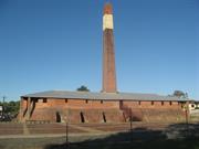
Constructed from 1927
For over 50 years the Maylands brickworks aided the growth of Perth by supplying the city with much needed clay bricks. Owing to its central position it was particularly important in the early years when road transport was not so well developed. The brickwork in the construction of the chimney and kilns is of interest and the building illustrates the technology of its period. With the curing shed, extruder shed and tower and associated rail tracks, trolleys, etc. the whole of the brick making process can be seen.
The kiln has brick external walls, brick vaulted kilns surrounding a central core, at ground level, with clay fill over the vaults and central core to form a level platform, under a metal clad roof. The platform was used for positioning of oil feed to burners, and observation openings for temperature and heat control. Until 1967 the kiln ran on powered coal but about this time it was changed to a natural gas system. The kiln dying was a continuous process, 24 hours a day, 7 days a week. One section of the kiln was being fired while another was being filled, and another emptied. Fenced off from the kiln are the extruder shed and tower, curing shed and the remains of rail tracks and trolleys, buildings of corrugated iron with timber supports.
Clay was found by the Metropolitan Brick Co. Ltd on the Maylands Peninsula in 1922 and clay bearing land was purchased. In 1927 a proposal for using the clay on site was accepted and the brickworks was completed using a single chimney 18 chamber 15ft diameter Hoffman Kiln, with a 7 million per year brick producing capacity. A second kiln was brought to the site in 1936 but this was dismantled in the 1970s. The original kiln continued in operation until early in 1983 when the brickworks were shut down and production ceased permanently.
The kiln is in good condition, but the rest of the buildings on site are deteriorating
| Owner | Category |
|---|---|
| City of Stirling | Local Gov't |
This information is provided voluntarily as a public service. The information provided is made available in good faith and is derived from sources believed to be reliable and accurate. However, the information is provided solely on the basis that readers will be responsible for making their own assessment of the matters discussed herein and are advised to verify all relevant representations, statements and information.
Constructed from 1927
This highly valued site is representative of the industrial development of the area, a phase of development that was predominant on the Maylands Peninsula and now no longer exists. The site demonstrates a high degree of technical innovation and is important for its association with Mssrs Law and Atkin, the developers of the site. It is a significant landmark on the Maylands Peninsula.
The site comprises a Hoffman Kiln with a 34m stack, pug mill, drying sheds, workshop, gate house, office and recent pavings and fences. The site represents all the processes of brick manufacture and has been adopted for public access and interpretation. It is a brick structure with vaulted brick walls and roof, together with iron oversailing roof.
The brickworks is a significant industrial, archeological site and together with the clay pits are a significant man-made feature. The brickworks illustrate the utilisation of the clay deposits in the period between 1927 and 1983 and demonstrate the industrial development of the area. The place illustrates the prevailing working conditions of employees in the brick making industry. The brickworks are important for their association with Mssrs Law and Atkin, the developers of the site. Law and Atkin established the Metropolitan Brick Company in 1906 and were leading industrialists. The works used local clay, and operated from 1927 to 1983, demonstrating a high degree of technical achievement. Maylands Brickworks, when in maximum production, comprised two Hoffman Kilns, two Pug Mills, extensive drying sheds and a lunch room. At the time of closure in 1983, one of the Hoffman Kilns and one of the Pug Mills had been removed (circa 1970). A large expanse of the drying sheds was also removed, with only a representative section between the Hoffman Kiln and Pug Mill retained. The lunch room was removed after closure. The clay pits are now flooded and provide an important environmental landscape feature, regarded highly by the local community.
Integrity - High Authenticity - High
Good condition and generally structurally stable.
| Ref Number | Description |
|---|---|
| 233 | Local Heritage Survey Number |
| Owner | Category |
|---|---|
| City of Bayswater | Local Gov't |
This information is provided voluntarily as a public service. The information provided is made available in good faith and is derived from sources believed to be reliable and accurate. However, the information is provided solely on the basis that readers will be responsible for making their own assessment of the matters discussed herein and are advised to verify all relevant representations, statements and information.
134 Whatley Cr Maylands
153-157 Guildford Rd & Sixth Av
Senses Foundation Inc
WA Ballet Centre
Bayswater
Metropolitan
Constructed from 1937 to 1955
| Type | Status | Date | Documents |
|---|---|---|---|
| Heritage List | Adopted | 25 Feb 2020 | |
| State Register | Registered | 28 Feb 1995 | HCWebsite.Listing+ListingDocument, HCWebsite.Listing+ListingDocument |
| Type | Status | Date | Documents |
|---|---|---|---|
| (no listings) |
| Type | Status | Date | Grading/Management | |
|---|---|---|---|---|
| Category | ||||
| Art Deco Significant Bldg Survey | Completed | 30 Jun 1994 | ||
| Register of the National Estate | Indicative Place | |||
| Classified by the National Trust | Classified | 03 Dec 1990 | ||
| Classified by the National Trust | YES | 12 Apr 1990 | ||
| Municipal Inventory | Adopted | 17 Jun 1997 | Classification 1 | |
| Local Heritage Survey | Adopted | 25 Feb 2020 | Classification 1 | |
Damaged by fire 24/7/07. Ground floor room and upper storey and roof damaged.
| Name | Type | Year From | Year To |
|---|---|---|---|
| Mr A E Clare | Architect | - | - |
| Finlay & Stoneman | Architect | - | - |
| Library Id | Title | Medium | Year Of Publication |
|---|---|---|---|
| 6845 | Royal WA Institute for the Blind, 134 Whatley Crescent, Maylands WA : submission to Heritage Council of WA. | Report | 2004 |
| 9788 | Senses toilet block, Maylands. Detailed archive record. | Archival Record | 2011 |
| 7733 | Senses, Maylands: conservation plan. | Heritage Study {Cons'n Plan} | 2006 |
| 9836 | Interpretation plan Senses, Maylands | Heritage Study {Other} | 2011 |
| 1655 | The Royal Institute for the Blind : administration building : physical assessment and conservation policy. | Report | 1996 |
| 8385 | Senses, Maylands : archival report. | Archival Record | 2006 |
| 9058 | Final interpretation plan Senses, Maylands. | Heritage Study {Other} | 2007 |
| 6622 | Administration building the Royal WA Institute for the Blind : heritage assessment and conservation report. | Heritage Study {Other} | 1995 |
Individual Building or Group
| Epoch | General | Specific |
|---|---|---|
| Present Use | HEALTH | Hospital |
| Original Use | HEALTH | Hospital |
| Style |
|---|
| Inter-War Art Deco |
| Inter-War Stripped Classical |
| Type | General | Specific |
|---|---|---|
| Wall | BRICK | Common Brick |
| General | Specific |
|---|---|
| SOCIAL & CIVIC ACTIVITIES | Community services & utilities |
| SOCIAL & CIVIC ACTIVITIES | Education & science |
| SOCIAL & CIVIC ACTIVITIES | Institutions |
This information is provided voluntarily as a public service. The information provided is made available in good faith and is derived from sources believed to be reliable and accurate. However, the information is provided solely on the basis that readers will be responsible for making their own assessment of the matters discussed herein and are advised to verify all relevant representations, statements and information.
The building provides visual variety and interest to the Maylands townscape. The decorative embellishments are unique examples of sculptural decoration of the period. The building is familiar to most, representing strength, security, reliability and stability for the community. It is a unique example of industrial architecture from the inter-war period in WA, and is one of the few remaining significant buildings from this period. It is also one of the few remaining industrial buildings in Perth of historical value. The building is also significant for originally providing training and employment for blind and disabled people in Perth, and allowing them to achieve a sense of accomplishment in producing highly marketable products.
The building has a large frontage with the driveway encompassing several parking bays. A low brick wall stands either side of a central pathway enhanced by a well maintained garden. Together with flagpoles situated either side of the entrance, the overall picture exemplifies important architectural elements of modern design. The architectural features of the building are made up of symmetrical, positive forms, with the main central tower drawing attention to the entrance. An important element of 1930's architecture is a 'stepped' design; this is incorporated by porticos symmetrically placed either side of the central tower. A finial stands proud on the main tower supporting a third flagpole. This façade displays horizontal bands of vertical windows, tied together in long stretches; the two contrasting directional lines typical of the style. The building is constructed from large stone blocks, and has a paint finish producing a striking visual landmark. A horizontal band of decorative sculptured concrete encompasses the building consisting of small vertical pilasters with upright and inverted 'waves of prosperity'. The wave is one of the many Art Deco symbols, popular at the time, symbolic of the wave of prosperity that swept through Perth after the depression and before the onset of the war. The entrance is surrounded by a chevron motif, with ventilation grilles repeating this unique motif, located either side of the doors. A positive vertical form is extended by the windows above the highly decorative spandrel. Incised horizontal banding is contrasted by the vertical elements of the fountain motif. A zig-zag form is introduced to break the directional lines creating further visual interest. Pilasters are symmetrically placed either side of the doorway with the chevron motif repeated on the capitals. A typical horizontal window light is featured above the door. The decorative portal exemplifies 1930s architecture, drawing attention to the entrance of the building. The exterior design of the Institute conforms to its original inner function. The central tower not only provides a dominant form to the façade, a stylistic device popular in modern architecture, it also forms a reception area leading into the showroom. Jarrah doors embellished with chrome stripping enhance the area. Symmetrical columns repeat the fountain motif on the capitals, with adjacent wrought iron balustrading formed into the fountain symbol. Streams of natural light adorn the showroom from vertical paned windows. Ventilators are sculptured with inverted and upright wave motifs. Vertical banding applied to the cornices enhance the coffered ceiling, both details typical of the style. The far internal wall incorporates a distinct horizontal band of windows above the door leading to administration offices. Jarrah floorboards are apparent throughout the building, as are jarrah doors with bubble glass inserts. The doors are fitted with chrome handles featuring the 'stepped' design element. The main administration office accommodates a fireplace exemplifying the 1930s, with a jarrah mantlepiece providing a focal point of interest. The ceiling is divided into two sections, implying a stylised version of Edwardian design. These divisions complete with decorative cornices are finished in appropriate modern colours.
Founded in 1895, the Royal WA Institute and Industrial School for the Blind was established as a permanent memorial to commemorate the Diamond Jubilee of Queen Victoria. The buildings occupying the increasing number of employees were initially very small and cramped, and thus in 1937 extensive additions were made to the factory, with the new Art Deco style addition officially opening on 28 July 1937. The building was opened by J. C. Willcock MLA, and the extensions were designed by C.E. Clare. Since 2001, the site has become the home of the West Australian Ballet, being renamed the WA Ballet Centre.
Good overall condition
| Name | Type | Year From | Year To |
|---|---|---|---|
| C.E. Clare | Architect | 1937 | 1937 |
This information is provided voluntarily as a public service. The information provided is made available in good faith and is derived from sources believed to be reliable and accurate. However, the information is provided solely on the basis that readers will be responsible for making their own assessment of the matters discussed herein and are advised to verify all relevant representations, statements and information.
Constructed from 1937, Constructed from 1935
The site is a representative example of the InterWar Stripped Classical architectural style and is a landmark feature within the Whatley Crescent streetscape. It has historic importance for its social and educational associations with disadvantaged people within Perth.
The site comprises a number of stages of development of offices, showrooms, workshops and stores. The Whatley Crescent buildings are distinguished by their strong styling, while the remaining structures are modest and utilitarian. The buildings are made of brick construction with the facade of the 1937 building being rendered. The building is distinguished by its stripped classical rendering and modern decorative motifs. It has recently been repainted.
The construction of the 1937 building demonstrates a commitment by the government and community to increase vocational opportunities for the blind in Western Australian in the early twentieth century. The Royal WA Institute for the Blind has performed an important social function since the turn-of-the-century, by providing a section of disadvantaged people in the community with vocational training and educational opportunities that would have otherwise been largely unavailable. The 1937 building has social value in the community as the 'public face' of The Royal WA Institute for the Blind. The building is a fine example of the Inter-War Stripped Classical Style. It is one of the few examples of a prominent Western Australian government institution which features strong abstract geometric (Art Deco) detailing.
Integrity - High Authenticity - High
Good
| Ref Number | Description |
|---|---|
| 249 | Local Heritage Survey Number |
This information is provided voluntarily as a public service. The information provided is made available in good faith and is derived from sources believed to be reliable and accurate. However, the information is provided solely on the basis that readers will be responsible for making their own assessment of the matters discussed herein and are advised to verify all relevant representations, statements and information.
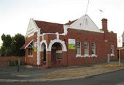
160 Whatley Cr Maylands
Antiques & Collectors
Maylands Post Office (fmr)
Bayswater
Metropolitan
Constructed from 1910, Constructed from 2001
| Type | Status | Date | Documents |
|---|---|---|---|
| Heritage List | Adopted | 25 Feb 2020 | |
| State Register | Registered | 08 Jan 2010 | HCWebsite.Listing+ListingDocument, HCWebsite.Listing+ListingDocument |
| Type | Status | Date | Documents |
|---|---|---|---|
| (no listings) |
| Type | Status | Date | Grading/Management | |
|---|---|---|---|---|
| Category | ||||
| Municipal Inventory | Adopted | 17 Jun 1997 | Classification 2 | |
| Local Heritage Survey | Adopted | 25 Feb 2020 | Classification 1 | |
Maylands Post Office (fmr) is in very good condition internally and externally as a result of ongoing use and maintenance.
| Name | Type | Year From | Year To |
|---|---|---|---|
| Ross, Clarence Rose | Architect | - | - |
Individual Building or Group
| Epoch | General | Specific |
|---|---|---|
| Present Use | COMMERCIAL | Office or Administration Bldg |
| Original Use | Transport\Communications | Comms: Post or Telegraph Office |
| Style |
|---|
| Federation Free Classical |
| Type | General | Specific |
|---|---|---|
| Wall | BRICK | Other Brick |
| Roof | TILE | Other Tile |
| General | Specific |
|---|---|
| DEMOGRAPHIC SETTLEMENT & MOBILITY | Land allocation & subdivision |
| DEMOGRAPHIC SETTLEMENT & MOBILITY | Settlements |
| TRANSPORT & COMMUNICATIONS | Mail services |
This information is provided voluntarily as a public service. The information provided is made available in good faith and is derived from sources believed to be reliable and accurate. However, the information is provided solely on the basis that readers will be responsible for making their own assessment of the matters discussed herein and are advised to verify all relevant representations, statements and information.
Constructed from 1910
The place is significant for its associations with the development of the Maylands Townsite and has aesthetic value, contributing to the Whatley Crescent streetscape.
A single storey face brick with stucco decorative treatments and a tiled roof. There are gables addressing both streets and a corner entry portico. There is a tiled roof to the awning over the Whatley Crescent window. There are touches of arts and crafts detailing to this simple utilitarian building.
The post office is an integral part in the developing story of the growth of the commercial heart of Maylands, being its first permanent post office and built at a time when the state still built post offices on behalf of the young Commonwealth. It is understood that Silvercock and Hayes built the place for 736 pound. While the post office was closed in 1988, it has considerable aesthetic and historic value in developing the theme of the establishment and growth of the Maylands Town Centre.
Integrity - Low Authenticity - High
Fair
| Name | Type | Year From | Year To |
|---|---|---|---|
| Clarence Rose Ross | Architect | 1910 | - |
This information is provided voluntarily as a public service. The information provided is made available in good faith and is derived from sources believed to be reliable and accurate. However, the information is provided solely on the basis that readers will be responsible for making their own assessment of the matters discussed herein and are advised to verify all relevant representations, statements and information.
178-182 Whatley Cr Maylands
Was originally place 9995
Bayswater
Metropolitan
Constructed from 1898
| Type | Status | Date | Documents |
|---|---|---|---|
| Heritage List | Adopted | 25 Feb 2020 |
| Type | Status | Date | Documents |
|---|---|---|---|
| (no listings) |
| Type | Status | Date | Grading/Management | |
|---|---|---|---|---|
| Category | ||||
| Municipal Inventory | Adopted | 17 Jun 1997 | Classification 2 | |
| Local Heritage Survey | Adopted | 25 Feb 2020 | Classification 1 | |
14896 Whatley Crescent Group, Maylands
Individual Building or Group
| Epoch | General | Specific |
|---|---|---|
| Original Use | OTHER | Other |
This information is provided voluntarily as a public service. The information provided is made available in good faith and is derived from sources believed to be reliable and accurate. However, the information is provided solely on the basis that readers will be responsible for making their own assessment of the matters discussed herein and are advised to verify all relevant representations, statements and information.
Constructed from 1898
This place is a representative example of an early shop and has historic value for its association with the development of the Maylands townsite, making a significant contribution to this streetscape.
A classically derived and orthodox interpretation of classical treatments with three shops treated as one entity. The corner is marked with a pediment as is the centre of the terrace. The shopfronts appear to be original. It is a single storey structure with brick and stucco walls, an iron roof and a suspended awning over the pavements.
An integral component of the Whatley Crescent and Eighth Ave precincts and a place of aesthetic value in its own right. This is an architecturally pleasing composition that relates well to its important corner location and defines the entry to Eighth Ave.
Integrity - High Authenticity - High
Good
This information is provided voluntarily as a public service. The information provided is made available in good faith and is derived from sources believed to be reliable and accurate. However, the information is provided solely on the basis that readers will be responsible for making their own assessment of the matters discussed herein and are advised to verify all relevant representations, statements and information.
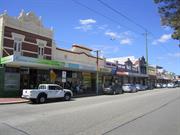
178-206 Whatley Cr MAYLANDS
21/9/2011 Address also includes: 70-88 Eighth Avenue, Maylands. VFL
Bayswater
Metropolitan
Constructed from 1902 to 1924
| Type | Status | Date | Documents |
|---|---|---|---|
| Heritage Agreement | YES | 27 Oct 2009 | HCWebsite.Listing+ListingDocument |
| State Register | Registered | 18 Dec 2009 | HCWebsite.Listing+ListingDocument, HCWebsite.Listing+ListingDocument |
| Type | Status | Date | Documents |
|---|---|---|---|
| (no listings) |
| Type | Status | Date | Grading/Management | |
|---|---|---|---|---|
| Category | ||||
| (no listings) | ||||
Generally sound to good. Most are maintained. Only shopfront at No.204 is damaged.
| Name | Type | Year From | Year To |
|---|---|---|---|
| F. W. Upton, architect of no.s 188-190 and 198-202 | Architect | - | - |
| J. F. Allen, arhitect of no.s 178-182 | Architect | - | - |
| Library Id | Title | Medium | Year Of Publication |
|---|---|---|---|
| 9528 | Maymont, Whatley Crescent: conservation of existing heritage facades, Whately Crescent group, Maylands - heritage sign-off. | Conservation works report | 2009 |
| 9527 | Maymont, Whatley Crescent: conservation of existing heritage facades, Whatley Crescent group, Maylands - progress report. | Conservation works report | 2009 |
Precinct or Streetscape
| Epoch | General | Specific |
|---|---|---|
| Other Use | RESIDENTIAL | Other |
| Original Use | Transport\Communications | Rail: Housing or Quarters |
| Other Use | COMMERCIAL | Other |
| Original Use | COMMERCIAL | Shopping Complex |
| Present Use | COMMERCIAL | Other |
| Style |
|---|
| Federation Free Style |
| Federation Free Classical |
| Type | General | Specific |
|---|---|---|
| Wall | BRICK | Painted Brick |
| General | Specific |
|---|---|
| DEMOGRAPHIC SETTLEMENT & MOBILITY | Depression & boom |
| DEMOGRAPHIC SETTLEMENT & MOBILITY | Land allocation & subdivision |
| TRANSPORT & COMMUNICATIONS | Rail & light rail transport |
| SOCIAL & CIVIC ACTIVITIES | Community services & utilities |
| DEMOGRAPHIC SETTLEMENT & MOBILITY | Immigration, emigration & refugees |
This information is provided voluntarily as a public service. The information provided is made available in good faith and is derived from sources believed to be reliable and accurate. However, the information is provided solely on the basis that readers will be responsible for making their own assessment of the matters discussed herein and are advised to verify all relevant representations, statements and information.
188-190 Whatley Cr Maylands
Also part of P15823 Eight Avenue Precinct which was reviewed on 30/09/05 and was decided not to be assessed.
Bayswater
Metropolitan
Constructed from 1900
| Type | Status | Date | Documents |
|---|---|---|---|
| Heritage List | Adopted | 25 Feb 2020 |
| Type | Status | Date | Documents |
|---|---|---|---|
| (no listings) |
| Type | Status | Date | Grading/Management | |
|---|---|---|---|---|
| Category | ||||
| Municipal Inventory | Adopted | 17 Jun 1997 | Classification 2 | |
| Local Heritage Survey | Adopted | 25 Feb 2020 | Classification 1 | |
14896 Whatley Crescent Group, Maylands
Individual Building or Group
| Epoch | General | Specific |
|---|---|---|
| Original Use | COMMERCIAL | Shop\Retail Store {single} |
| Present Use | COMMERCIAL | Shop\Retail Store {single} |
| General | Specific |
|---|---|
| OCCUPATIONS | Commercial & service industries |
This information is provided voluntarily as a public service. The information provided is made available in good faith and is derived from sources believed to be reliable and accurate. However, the information is provided solely on the basis that readers will be responsible for making their own assessment of the matters discussed herein and are advised to verify all relevant representations, statements and information.
Constructed from 1900
This place is a representative example of an early shop and has historic value for its association with the development of the Maylands townsite, making a significant contribution to this streetscape.
A pair of shops with a decorative roof level parapet showing arts and crafts influences in its design. The dado has authentic tiles of green and maroon and the metal shopfronts appear to be authentic. The whole of the masonry has been painted over on the street façade. It has stucco brick walls and an iron roof. It also has an authentic steel framed and iron clad awning.
An authentic and good example of an early suburban shop that makes an important contribution to the town centre streetscape.
Integrity - High Authenticity - High
Fair
| Ref Number | Description |
|---|---|
| 258 | Local Heritage Survey Number |
This information is provided voluntarily as a public service. The information provided is made available in good faith and is derived from sources believed to be reliable and accurate. However, the information is provided solely on the basis that readers will be responsible for making their own assessment of the matters discussed herein and are advised to verify all relevant representations, statements and information.
192-194 Whatley Cr Maylands
Also part of P15823 Eight Avenue Precinct which was reviewed on 30/09/05 and was decided not to be assessed.
Bayswater
Metropolitan
Constructed from 1900
| Type | Status | Date | Documents |
|---|---|---|---|
| Heritage List | Adopted | 25 Feb 2020 |
| Type | Status | Date | Documents |
|---|---|---|---|
| (no listings) |
| Type | Status | Date | Grading/Management | |
|---|---|---|---|---|
| Category | ||||
| Municipal Inventory | Adopted | 17 Jun 1997 | Classification 2 | |
| Local Heritage Survey | Adopted | 25 Feb 2020 | Classification 1 | |
14896 Whatley Crescent Group, Maylands
Individual Building or Group
| Epoch | General | Specific |
|---|---|---|
| Original Use | COMMERCIAL | Shop\Retail Store {single} |
| Present Use | COMMERCIAL | Shop\Retail Store {single} |
| General | Specific |
|---|---|
| OCCUPATIONS | Commercial & service industries |
This information is provided voluntarily as a public service. The information provided is made available in good faith and is derived from sources believed to be reliable and accurate. However, the information is provided solely on the basis that readers will be responsible for making their own assessment of the matters discussed herein and are advised to verify all relevant representations, statements and information.
Constructed from 1900
This place is a representative example of an early shop and has historic value for its association with the development of the Maylands townsite, making a significant contribution to this streetscape.
A single storey pair of shops in a very basic, classically derived design with an original shop front and a suspended canopy over the pavement.
A terrace of two shops demonstrating the classically derived design mode in its sparest form. An important contribution to the Whatley Crescent precinct with minor aesthetic value.
Integrity - High Authenticity - High
Fair
| Ref Number | Description |
|---|---|
| 259 | Local Heritage Survey Number |
This information is provided voluntarily as a public service. The information provided is made available in good faith and is derived from sources believed to be reliable and accurate. However, the information is provided solely on the basis that readers will be responsible for making their own assessment of the matters discussed herein and are advised to verify all relevant representations, statements and information.
196 Whatley Cr Maylands
Also part of P15823 Eight Avenue Precinct which was reviewed on 30/09/05 and was decided not to be assessed.
Shop/Dwelling
Bayswater
Metropolitan
Constructed from 1898
| Type | Status | Date | Documents |
|---|---|---|---|
| Heritage List | Adopted | 25 Feb 2020 |
| Type | Status | Date | Documents |
|---|---|---|---|
| (no listings) |
| Type | Status | Date | Grading/Management | |
|---|---|---|---|---|
| Category | ||||
| Municipal Inventory | Adopted | 17 Jun 1997 | Classification 2 | |
| Local Heritage Survey | Adopted | 25 Feb 2020 | Classification 1 | |
14896 Whatley Crescent Group, Maylands
Individual Building or Group
| Epoch | General | Specific |
|---|---|---|
| Present Use | COMMERCIAL | Office or Administration Bldg |
| Original Use | COMMERCIAL | Office or Administration Bldg |
| General | Specific |
|---|---|
| OCCUPATIONS | Commercial & service industries |
This information is provided voluntarily as a public service. The information provided is made available in good faith and is derived from sources believed to be reliable and accurate. However, the information is provided solely on the basis that readers will be responsible for making their own assessment of the matters discussed herein and are advised to verify all relevant representations, statements and information.
Constructed from 1898
This place is a representative example of an early shop with an attached residence and has historic value for its association with the development of the Maylands townsite, making a significant contribution to this streetscape.
A two storey shop and residence with a richly decorated parapet that freely interprets classical elements. An earlier two storey verandah has been replaced by a cantilevered awning. It has brick and stucco walls, with an iron roof and a timber framed shop front.
One of the most elaborate shops in the precinct, having great aesthetic value as well as being an integral part of the precinct. It appears to be one of the earlier shops in the precinct of Whatley Crescent.
Integrity - High Authenticity - High
Good
| Ref Number | Description |
|---|---|
| 260 | Local Heritage Survey Number |
This information is provided voluntarily as a public service. The information provided is made available in good faith and is derived from sources believed to be reliable and accurate. However, the information is provided solely on the basis that readers will be responsible for making their own assessment of the matters discussed herein and are advised to verify all relevant representations, statements and information.
202 Whatley Cr Maylands
Also part of P15823 Eight Avenue Precinct which was reviewed on 30/09/05 and was decided not to be assessed.
Maylands Pre Owned Shop
three shops appear t
Bayswater
Metropolitan
Constructed from 1900
| Type | Status | Date | Documents |
|---|---|---|---|
| Heritage List | Adopted | 25 Feb 2020 |
| Type | Status | Date | Documents |
|---|---|---|---|
| (no listings) |
| Type | Status | Date | Grading/Management | |
|---|---|---|---|---|
| Category | ||||
| Local Heritage Survey | Adopted | 25 Feb 2020 | Classification 1 | |
| Municipal Inventory | Adopted | 17 Jun 1997 | Classification 2 | |
14896 Whatley Crescent Group, Maylands
Individual Building or Group
| Epoch | General | Specific |
|---|---|---|
| Present Use | COMMERCIAL | Shop\Retail Store {single} |
| Original Use | COMMERCIAL | Shop\Retail Store {single} |
| General | Specific |
|---|---|
| OCCUPATIONS | Commercial & service industries |
This information is provided voluntarily as a public service. The information provided is made available in good faith and is derived from sources believed to be reliable and accurate. However, the information is provided solely on the basis that readers will be responsible for making their own assessment of the matters discussed herein and are advised to verify all relevant representations, statements and information.
Constructed from 1900
This place is a representative example of an early shop and has historic value for its association with the development of the Maylands townsite, making a significant contribution to this streetscape.
This is a classically derived terrace of three shops with a central pediment bay flanked by symmetrically disposed bays. The upper balustrade is panelled and all three shops appear to have authentic shop fronts. The canopy is a replacement. It has stucco finished brickwork with a suspended canopy over the footpath and a metal framed shopfront.
A very important part of the Whatley Crescent historic commercial precinct. The terrace of three shops that have considerable aesthetic value. The dwelling behind was originally the Maylands Station Master's house.
Integrity - High Authenticity - High
Fair
This information is provided voluntarily as a public service. The information provided is made available in good faith and is derived from sources believed to be reliable and accurate. However, the information is provided solely on the basis that readers will be responsible for making their own assessment of the matters discussed herein and are advised to verify all relevant representations, statements and information.
204 Whatley Cr Maylands
Also part of P15823 Eight Avenue Precinct which was reviewed on 30/09/05 and was decided not to be assessed.
Tent Shop
Bayswater
Metropolitan
Constructed from 1903
| Type | Status | Date | Documents |
|---|---|---|---|
| Heritage List | Adopted | 25 Feb 2020 |
| Type | Status | Date | Documents |
|---|---|---|---|
| (no listings) |
| Type | Status | Date | Grading/Management | |
|---|---|---|---|---|
| Category | ||||
| Municipal Inventory | Adopted | 17 Jun 1997 | Classification 1 | |
| Local Heritage Survey | Adopted | 25 Feb 2020 | Classification 1 | |
14896 Whatley Crescent Group, Maylands
Individual Building or Group
| Epoch | General | Specific |
|---|---|---|
| Present Use | COMMERCIAL | Shop\Retail Store {single} |
| Original Use | COMMERCIAL | Shop\Retail Store {single} |
| General | Specific |
|---|---|
| OCCUPATIONS | Commercial & service industries |
This information is provided voluntarily as a public service. The information provided is made available in good faith and is derived from sources believed to be reliable and accurate. However, the information is provided solely on the basis that readers will be responsible for making their own assessment of the matters discussed herein and are advised to verify all relevant representations, statements and information.
Constructed from 1900
This place is a representative example of an early shop and has historic value for its association with the development of the Maylands townsite, making a significant contribution to this streetscape.
This is a classically derived terrace of three shops with a central pediment bay flanked by symmetrically disposed bays. The upper balustrade is panelled and all three shops appear to have authentic shop fronts. The canopy is a replacement. It has stucco finished brickwork with a suspended canopy over the footpath and a metal framed shopfront.
A very important part of the Whatley Crescent historic commercial precinct. The terrace of three shops that haveconsiderable aesthetic value. The dwelling behind was originally the Maylands Station Master's house.
Integrity - High Authenticity - High
This information is provided voluntarily as a public service. The information provided is made available in good faith and is derived from sources believed to be reliable and accurate. However, the information is provided solely on the basis that readers will be responsible for making their own assessment of the matters discussed herein and are advised to verify all relevant representations, statements and information.