Local Government
Cambridge
Region
Metropolitan
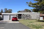
2 Keaney Pl City Beach
Cambridge
Metropolitan
Constructed from 1974, Constructed from 1965
| Type | Status | Date | Documents |
|---|---|---|---|
| (no listings) |
| Type | Status | Date | Documents |
|---|---|---|---|
| (no listings) |
| Type | Status | Date | Grading/Management | |
|---|---|---|---|---|
| Category | ||||
| Municipal Inventory | Adopted | 11 Dec 1996 | ||
| Municipal Inventory | Adopted | 27 Nov 2018 | Category 4 | |
| Name | Type | Year From | Year To |
|---|---|---|---|
| Forbes & Fitzharding | Architect | - | - |
Individual Building or Group
| Epoch | General | Specific |
|---|---|---|
| Present Use | EDUCATIONAL | Combined School |
| Present Use | RELIGIOUS | Church, Cathedral or Chapel |
| Original Use | EDUCATIONAL | Combined School |
| Original Use | RELIGIOUS | Church, Cathedral or Chapel |
| Style |
|---|
| Late 20th-Century Organic |
| Type | General | Specific |
|---|---|---|
| Roof | TILE | Ceramic Tile |
| Wall | BRICK | Common Brick |
| General | Specific |
|---|---|
| SOCIAL & CIVIC ACTIVITIES | Religion |
| SOCIAL & CIVIC ACTIVITIES | Education & science |
This information is provided voluntarily as a public service. The information provided is made available in good faith and is derived from sources believed to be reliable and accurate. However, the information is provided solely on the basis that readers will be responsible for making their own assessment of the matters discussed herein and are advised to verify all relevant representations, statements and information.
Constructed from 1965
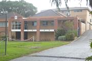
15020 All Saints Church and Crawford Hall
The Holy Spirit Parish Complex has some aesthetic value as a collection of buildings that demonstrate styles from the late 20th century and early 21st century. The Holy Spirit Church is an outstanding example of the Late 20th Century Organic style. The Parish complex has historic value for its association with the establishment and development of the Catholic community in City Beach from 1960. The Parish complex has historic and social value for the many members of the community who contributed to the creation of the church, school and parish complex through their donations of time and money. The Parish complex has social value for the members of the Catholic and wider community as the venue for the provision of education and spiritual services since 1965. The church is of high aesthetic significance as an example of modern architecture in Perth and as a landmark in the City Beach area.
The Holy Spirit complex includes the Administration Centre, Presbytery and Primary School in addition to the prominent Holy Spirit Church. The Church is the major feature of the site. The primary school and parish centre are largely brick and tile constructions.
As this part of the metropolitan area developed in the period following World War II, the Roman Catholic Church recognised the need to establish facilities for members of their community. In 1960, Archbishop Prendiville sent Father Thomas Phelan to establish the new Roman Catholic Parish of City Beach and in 1963 this site was purchased. At the time of the inauguration of the Parish there was a Catholic population of only fifty five families. Infrastructure development was very slow and there was no access to the Church site for a few years. Brompton Road divided two council; Perth City and Stirling but eventually both councils combined to build part of Brompton Road. Much of the preparatory work for the buildings on the site was done by donation. Holy Spirit Presbytery was built during 1964, having been designed, free of cost, by an architect from the Public Works Department. Survey work for the location of the future buildings was undertaken by new architecture graduate, Mike Fitzhardinge who also designed the school. In 1965, five classrooms were completed and the Holy Spirit school was opened under the founding Principal Sister Mary Dominica with 33 children. These rooms served the community as a church until the completion of the church in 1974. Holy Spirit Church was designed by Forbes and Fitzhardinge Architects and its unusual design led to the achievement of awards. The Holy Spirit Church was blessed and opened for worship by Archbishop Goody on Sunday March 31st 1974. In 1980, the Parish Centre was opened which served until the new Parish Centre was opened in 2007. Also during the 1980s, facilities at the school were increased with the provision of a new pre primary centre, administrative block and library. In 1995, the school underwent a significant building program with the provision of a new covered assembly area, administration centre and new classrooms. Since then the school continues to be adapted and extended in response to the changing needs of the community and educational standards and practices. In 2011, the parish complex was assessed with the Holy Spirit Catholic Church by the State Heritage Office, and although part of the Holy Spirit Church documentation, the parish complex was found to be of little significance.
Integrity: High Authenticity: High
Very Good
| Name | Type | Year From | Year To |
|---|---|---|---|
| Mike Fitzhardinge | Architect | 1964 | 1965 |
| Ref ID No | Ref Name | Ref Source | Ref Date |
|---|---|---|---|
| Holy Spirit City Beach | Website | 2017 | |
| Aerial photographs, Landgate. | Online Reference Documents | 1953-2016 |
| Reserve | Lot/Location | Plan/Diagram | Vol/Folio |
|---|---|---|---|
| 1 | Diagram 27431 | 1264/590 |
| Owner | Category |
|---|---|
| Roman Catholic Archbishop | Church Property |
This information is provided voluntarily as a public service. The information provided is made available in good faith and is derived from sources believed to be reliable and accurate. However, the information is provided solely on the basis that readers will be responsible for making their own assessment of the matters discussed herein and are advised to verify all relevant representations, statements and information.
30 Marapana Rd City Beach
Cambridge
Metropolitan
Constructed from 1956
| Type | Status | Date | Documents |
|---|---|---|---|
| Heritage List | Adopted | 27 Nov 2018 |
| Type | Status | Date | Documents |
|---|---|---|---|
| (no listings) |
| Type | Status | Date | Grading/Management | |
|---|---|---|---|---|
| Category | ||||
| Municipal Inventory | Adopted | 17 Dec 1996 | ||
| Municipal Inventory | Adopted | 27 Nov 2018 | Category 3 | |
Individual Building or Group
| Epoch | General | Specific |
|---|---|---|
| Original Use | EDUCATIONAL | Primary School |
| Present Use | EDUCATIONAL | Primary School |
| Type | General | Specific |
|---|---|---|
| Other | TIMBER | Other Timber |
| Wall | ASBESTOS | Other Asbestos |
| General | Specific |
|---|---|
| SOCIAL & CIVIC ACTIVITIES | Education & science |
This information is provided voluntarily as a public service. The information provided is made available in good faith and is derived from sources believed to be reliable and accurate. However, the information is provided solely on the basis that readers will be responsible for making their own assessment of the matters discussed herein and are advised to verify all relevant representations, statements and information.
Constructed from 1968, Constructed from 1996, Constructed from 1956, Constructed from 2000, Constructed from 1958
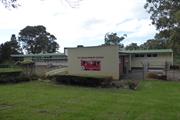
The place has aesthetic value for the remaining form and detail of a mid 20th century complex of educational buildings which continues to evolve and represent subsequent styles. The place has historic significance representing the history of settlement of City Beach in the period following World War II and the rapid population growth in the 1960s. The place has social value for the members of the local community, particularly past students and staff who attended the school.
The school is located on a corner plot, at a lower level than the surrounding roads. The school comprises a range of buildings of single storey construction which have been added to as demand for the school increased. The school is of brick construction with a shallow pitch colorbond roof. A feature parapet wall of painted brick construction with “City Beach Primary School” emblazoned across it creates the entry statement of the school. The school is of face brick and painted brick construction with timber framed windows, deep overhang of the roof providing some shade to the windows and additional shade structures positioned midway up some of the windows. The school is located amidst an open green setting with trees and other planting, softening the utilitarian appearance of the school and helping it blend in with the residential character of the area. The three main ranges of the school are similar in their presentation and are arranged around the netball courts to the rear of the buildings.
The City Beach Primary School, consisting of 3 classrooms, was opened in 1957 and the formal proceedings were accompanied by a fete. When the school opened there was no electricity or sealed playgrounds. Water was provided from overhead tanks. Power was not installed until subdivision of the land surrounding the school at the beginning of 1961 and connection to the water mains only occurred on 19 May 1966. The school's enrolment grew steadily with enrolments reaching a peak in 1969 of over 480 children. This population growth was consistent with the rapid settlement of the area in the 1960s following the 1962 Empire/Commonwealth Games which resulted in opening up of lands for residential subdivision. Between 1959 and 1967, 5 new classrooms were constructed to meet the demands of increasing enrolments. On 19 July 1967 an Extraordinary General Meeting of the P&C Association was held at the Floreat Surf Club. At this meeting a motion was approved giving authority to the Executive Committee to proceed with the building of a Hall / Library / Canteen complex on the school site. The School Library and Canteen were funded and the building arranged by the P&C in 1968. The new library was used for the first time on 18 June 1968. On 8 July 1968 another school milestone was reached when the Canteen opened for business, 350 lunch orders were placed. In 1996, two rooms were renovated for the commencement of the new Fulltime 5 year old pre-primary unit. An internal wall was removed to make a larger room and a kitchenette installed. In 1997 the fulltime 5 year old pre-primary class commenced at the school site, moving from the premises on Boronia Crescent. All asbestos roofing was removed during the summer break between December 1997 and January 1998. The school's Undercover Assembly area was officially opened by Dr E Constable MLA on 16 October 2000. Since that time the school has undergone additions and alterations as required in accordance with the demands of the population and the evolution of teaching practice and standards. In 2009, a library and three new classrooms were constructed and in 2011 the administration block was extended and upgraded. In 2017, a new brick classroom block was constructed and transportable buildings were added to the site. It is currently proposed that a Japanese School will relocate to City Beach Primary School. The three original classrooms and administration area are still extant on the campus.
Integrity: High Authenticity: Moderate
Good
| Name | Type | Year From | Year To |
|---|---|---|---|
| Public Works Department | Architect | 1957 | 2017 |
| Ref ID No | Ref Name | Ref Source | Ref Date |
|---|---|---|---|
| History of our School, City Beach Primary School w | Document from Website | 2017 | |
| WABMA Heritage Database |
| Reserve | Lot/Location | Plan/Diagram | Vol/Folio |
|---|---|---|---|
| R24779 | 6321 | Diagram 21255 | LR3155-694 |
| Owner | Category |
|---|---|
| Education Department | State Gov't |
This information is provided voluntarily as a public service. The information provided is made available in good faith and is derived from sources believed to be reliable and accurate. However, the information is provided solely on the basis that readers will be responsible for making their own assessment of the matters discussed herein and are advised to verify all relevant representations, statements and information.
14 Marimba Cr City Beach
Cambridge
Metropolitan
| Type | Status | Date | Documents |
|---|---|---|---|
| (no listings) |
| Type | Status | Date | Documents |
|---|---|---|---|
| (no listings) |
| Type | Status | Date | Grading/Management | |
|---|---|---|---|---|
| Category | ||||
| Municipal Inventory | Adopted | 27 Nov 2018 | Category 4 | |
Individual Building or Group
| Epoch | General | Specific |
|---|---|---|
| Present Use | RESIDENTIAL | Single storey residence |
| Original Use | RESIDENTIAL | Single storey residence |
| Style |
|---|
| Late 20th-Century Sydney Regional |
| Type | General | Specific |
|---|---|---|
| Roof | METAL | Zincalume |
| Wall | BRICK | Face Brick |
| General | Specific |
|---|---|
| PEOPLE | Innovators |
This information is provided voluntarily as a public service. The information provided is made available in good faith and is derived from sources believed to be reliable and accurate. However, the information is provided solely on the basis that readers will be responsible for making their own assessment of the matters discussed herein and are advised to verify all relevant representations, statements and information.
Constructed from 1966
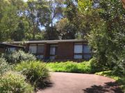
The place has aesthetic value as a good representative example of the Late 20th Century Sydney Regional style in its original landscaped setting. The place has historic value for its association with the development of City Beach in the 1960s which saw many families settling in the area. The place has historic value as an example of the period in the 1960s when there was considerable experimentation with traditional design principles that were being expressed in many areas, including architecture. The place has historic value for its association with architect Noel Ryan who designed this residence for his family.
Elevated single storey red/brown brick house with shallow pitched roof. The façade is a combination of brick panels and full height windows, arranged in groups of two or three. The entrance is set back behind the main building line creating a small porch area. The entrance includes timber door with full height side window and single pane fanlight extending across both elements. A paved verandah extends around part of the façade with brick retaining wall and is accessed via a flight of brick steps from the parking area/driveway.
This portion of City Beach underwent significant development in the post World War II period. The City of Perth released large portions of land for residential subdivision and this subdivision was approved by the Department of Lands and Surveys in 1959. The development of the area was strongly influenced by the construction of facilities for the Empire Games in 1962. This undulating lot was purchased by Noel and Anne Ryan for $5000 to build a family home. Noel Geoffrey Ryan (c1933-2016) was an architect with the local practice, Kenneth Broadhurst and Partners which were active in Western Australia from the 1950s to the 1980s. Noel Ryan prepared plans for the residence in March 1965, with reference to what was colloquially known as 'Nuts and Berry Sydney style' or the Late Twentieth-Century Sydney Regional Style which featured split level planning, extensive use of glass and panels of clinker brick. The builder was Patrick McCormick. When the lot was purchased the land was well covered with native vegetation which was retained where possible and the planting still reflects the original landscape. The Ryan family lived at the home until 2014. Following the transfer of the property to the current owner, renovations and alterations have been undertaken. These have included the replacement of the original roof cladding and ceiling. The current owner has provided information that the original building fabric is poor condition although this has not been sighted in this assessment.
Integrity: High Authenticity: Moderate
Good
| Name | Type | Year From | Year To |
|---|---|---|---|
| Noel Ryan | Architect | 1966 | 2016 |
| Ref ID No | Ref Name | Ref Source | Ref Date |
|---|---|---|---|
| Aerial photographs, Landgate | Online Resources | 1953-2016, |
| Reserve | Lot/Location | Plan/Diagram | Vol/Folio |
|---|---|---|---|
| 523 | Plan 7180 | 1290-307 |
| Owner | Category |
|---|---|
| Private owners | Other Private |
This information is provided voluntarily as a public service. The information provided is made available in good faith and is derived from sources believed to be reliable and accurate. However, the information is provided solely on the basis that readers will be responsible for making their own assessment of the matters discussed herein and are advised to verify all relevant representations, statements and information.
59 Oban Rd City Beach
Cambridge
Metropolitan
Constructed from 1969 to 1973
| Type | Status | Date | Documents |
|---|---|---|---|
| (no listings) |
| Type | Status | Date | Documents |
|---|---|---|---|
| (no listings) |
| Type | Status | Date | Grading/Management | |
|---|---|---|---|---|
| Category | ||||
| Municipal Inventory | Adopted | 27 Nov 2018 | Category 4 | |
Individual Building or Group
| Epoch | General | Specific |
|---|---|---|
| Original Use | RESIDENTIAL | Single storey residence |
| Style |
|---|
| Late 20th-Century International |
| Type | General | Specific |
|---|---|---|
| Wall | BRICK | Painted Brick |
| General | Specific |
|---|---|
| PEOPLE | Innovators |
This information is provided voluntarily as a public service. The information provided is made available in good faith and is derived from sources believed to be reliable and accurate. However, the information is provided solely on the basis that readers will be responsible for making their own assessment of the matters discussed herein and are advised to verify all relevant representations, statements and information.
Constructed from 1973
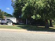
The place has some aesthetic value for the remnant elements and form of the late 20th century International style. The place has historic value for its association with prominent architect, Iwan Iwanoff who was influential in Western Australian practice for his non traditional approach to design and materials drawn from European trends. The place has historic value for its association with the late 1960s which was characterised as a period of affluence which was teamed with a willingness to experiment with new styles and materials. The place has social value as the house and others of Iwanoff's design are the source of study and interest amongst members of the community.
Single storey house characterised by a flat roof, a façade with full height windows and concrete block construction. The original open carport has been enclosed and part of the open porch has been enclosed by windows altering the design intent of the façade.
Iwan Nickolow Iwanoff (1919-1986) was born in Kusstendil, Bulgaria. After studying architecture in Munich at the Technische Hochschule from 1941, Iwanoff worked for Emil Freymuth with the pair winning second prize in the competition to rebuild the central area of Munich. Migrating to Australia as part of the International Refugee Organization resettlement scheme, Iwanoff and his wife arrived at Fremantle, on 2 March 1950. He worked with architecture firm Kranz and Sheldon and also Yuncken and Freeman in Melbourne. In 1963, he established his own practice, The Studio of Iwanoff. A gifted architect, Iwanoff had exceptional drawing abilities, an innovative `expressionistic’ approach to design and detailing and, above all, a conviction that architecture was an art. In 1963-86 his small office produced work of high quality, including numerous houses. He also designed shop fronts and interiors in central Perth, and one larger project, the civic administration centre and public library at Northam (1969-74). His creative use of concrete blocks is a noted feature of his work. Many of the Iwanoff residences designed in the 1960s and 1970s were in the new northern suburbs of Perth where there was minimal surrounding development and often a clientele willing to explore new styles and techniques. Plans for this residence were prepared in 1969 by 'The Studio of Iwanoff' and show that the original home was a simple three bedroom design of concrete block construction. The owners and occupiers until c1980 were social workers, John Warren Booth and Susan Betty Booth. In 1971, a swimming pool was constructed in the rear of the lot and in 1973, a large extension was added to the rear of the residence on the western side which changed the plan form of the residence to a 'L' shape. By 1987, the property was transferred to owners Barry and Nanette Bennett who engaged builders, Summit Homes, to redesign the interior layout of the residence to create an additional bedroom and family room. These additions resulted in the removal of portion of the rear terrace. In 1989, the Bennett's engaged Burke & Gaynor Homes to design a new entry and dining room at the front of the residence. Since that time the carport has been enclosed with a double garage door. These later additions have altered the presentation of the house to the street.
Integrity: High Authenticity: Low
Good
| Name | Type | Year From | Year To |
|---|---|---|---|
| Iwan Iwanoff | Architect | 1973 | 1973 |
| Ref ID No | Ref Name | Ref Source | Ref Date |
|---|---|---|---|
| Aerial photographs, Landgate | Online Resources | 1953-2016 | |
| Goad, Philip; Willis, Julie 'The Encyclopaedia of Australian Architecture', Cambridge University Press, p. 357. | Book | 2012 | |
| City of Perth | Plans | 1973 | |
| Duncan Richards, 'Iwanoff, Iwan (1919–1986)', Australian Dictionary of Biography, National Centre of Biography, Australian National University | Online Document | 2007 | |
| State Library of WA, Iwan Iwanoff Collection. MN1401, Acc 4400A | Plans |
| Reserve | Lot/Location | Plan/Diagram | Vol/Folio |
|---|---|---|---|
| 345 | Plan 8758 | 59-82A |
| Owner | Category |
|---|---|
| Private owners | Other Private |
This information is provided voluntarily as a public service. The information provided is made available in good faith and is derived from sources believed to be reliable and accurate. However, the information is provided solely on the basis that readers will be responsible for making their own assessment of the matters discussed herein and are advised to verify all relevant representations, statements and information.
145 Oceanic Dr City Beach
Cambridge
Metropolitan
Constructed from 1896 to 1987
| Type | Status | Date | Documents |
|---|---|---|---|
| Heritage List | Adopted | 27 Nov 2018 | |
| State Register | Registered | 13 Aug 2019 | HCWebsite.Listing+ListingDocument, HCWebsite.Listing+ListingDocument |
| Type | Status | Date | Documents |
|---|---|---|---|
| (no listings) |
| Type | Status | Date | Grading/Management | |
|---|---|---|---|---|
| Category | ||||
| Municipal Inventory | Adopted | 17 Dec 1996 | ||
| Municipal Inventory | Adopted | 27 Nov 2018 | Category 1 | |
| Name | Type | Year From | Year To |
|---|---|---|---|
| Diana & Ken Waldron | Architect | - | - |
| Library Id | Title | Medium | Year Of Publication |
|---|---|---|---|
| 11684 | Quarry Ampitheatre - concept masterplan | Electronic | 2012 |
| 11869 | Quarry Ampitheatre | Heritage Study {Cons'n Plan} | 2019 |
Historic site
| Epoch | General | Specific |
|---|---|---|
| Present Use | SOCIAL\RECREATIONAL | Other |
| Original Use | SOCIAL\RECREATIONAL | Other |
| Type | General | Specific |
|---|---|---|
| Wall | STONE | Limestone |
| General | Specific |
|---|---|
| SOCIAL & CIVIC ACTIVITIES | Cultural activities |
This information is provided voluntarily as a public service. The information provided is made available in good faith and is derived from sources believed to be reliable and accurate. However, the information is provided solely on the basis that readers will be responsible for making their own assessment of the matters discussed herein and are advised to verify all relevant representations, statements and information.
Constructed from 1978, Constructed from 1986, Constructed from 1834 to 1906, Constructed from 1894 to 1896
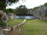
04499 Bold Park
Quarry Amphitheatre, City Beach comprising a 556 seat open air Amphitheatre located high upon Reabold Hill in City Beach with panoramic views of Bold Park towards the City, within a former limestone quarry, in a natural bushland setting, has cultural heritage significance for the following reasons: the place is unique in Western Australia as a former limestone quarry that has been adapted for re-use as an amphitheatre; the place is rare as an extant inner Perth metropolitan quarry associated with the development of the limestone quarrying industry in the late nineteenth century; the stone from the quarry was used in some of Perth's early buildings including the foundations of Perth Town Hall; the place is significant for its associations with prominent settlers Walter Padbury and Henry Trigg, who were significant figures in the early development of Western Australia; the place has aesthetic value for its bushland setting and unobstructed views of the city; the place has social significance to the local and wider community having been a venue for concerts, ballet and other cultural events since 1986; and the place is associated with Diana Waldron, founder of Perth City Ballet, who with her husband architect, Ken Waldron, was responsible for the inception, fundraising and construction of the Quarry. The administration building, toilets, kiosk and storage sheds and access areas north of the stage are of little significance.
Quarry Amphitheatre sits on northern slopes of Bold Park, accessed via Waldron Drive or Scenic Drive. The place consists of a former limestone quarry that has been adapted to form a theatre space, consisting of an Entrance, Auditorium, Stage, Backstage and rear area, set between two limestone faces. The Auditorium consists of a number of grassed tiers orientated in a southerly direction looking back towards the stage. The tiers are edged with concrete pavers and are divided into two sections by a central paved aisle. The Stage is a rectangular timber floor set on a steel frame with timber deck. The Backstage area is located below the stage
Following the foundation of Perth in August 1829, the townsite was laid out between Mount Eliza and what was to later become Heirisson Island. Limestone was in great demand for construction in the new colony. The earliest lime kilns in Western Australia were established at the initial settlement sites of Fremantle and Albany in the 1830s, where settlers had access to local supplies of limestone. During the early expansion of the Swan River colony, small kilns were established at Cottesloe, Peppermint Grove and Claremont from the 1850s to the 1890s. Henry Trigg, a carpenter and master builder from Gloucester, England arrived in the new colony of Western Australia in 1829. In I834, Trigg was granted 500 acres of land, which lay south of modern day Grantham Street, stretching from Floreat to the coastal sand hills. The western boundary of Trigg's land ran along the top of a limestone ridge. As a builder, Trigg recognised the value of this limestone outcropping and set up a quarrying and lime burning business. Trigg's business which became known as the 'Limekilns' prospered. In 1839, Trigg purchased neighbouring land to the south, including what is now Perry Lakes and One Tree Hill, (now known as Reabold Hill). In the same year, Trigg was appointed Superintendent of Public Works, and in this role was responsible for overseeing the erection of many early government buildings in Perth. In 1844, Walter Padbury, a pastoralist, acquired 426 acres of land adjacent to Trigg's property and later purchased Trigg's land including the Limekilns business for 2350, forming a 1,234 acre landholding which became known as the 'Limekilns Estate'. For the next 20 years Padbury built the Estate into a successful property, including the retention of the quarrying operations. At the height of operations, more than 50 men were employed at the quarry and lime kiln site. In 1869, brothers Henry and Somers Birch purchased the Limekilns Estate from Walter Padbury for £1,000. On 1 November 1875, during their ownership of the property, the explorer Ernest Giles arrived in Perth after his 2,500 mile journey from Port Augusta. During the 1890s, the Limekilns Estate served as a temporary quarantine station for camels imported to Western Australia to provide transport to the goldfields, with a lake on the property becoming known as Camel Lake. The Estate remained in the Birch's ownership until, 1880 when it was purchased by Joseph Perry for the sum of £1300. During his ownership, Perry kept the Quarry and limekilns in operation. Many of Perth's early public buildings, including the foundations of the Perth Town Hall (1870) were constructed using limestone from the quarry and kilns. In 1880, a portion of the Limekilns property was rented to Charles Ball. In an advertisement in the West Australian in May 1880, Ball offered to supply lime which was described as the most superior in the colony, from lime kilns of 30 years standing. Stone from the quarry was transported by a light narrow gauge horse drawn railway through the bush (roughly along the route of the present day Salvado Road) to Jolimont and then on to the Subiaco Railway Station. Private quarrying ceased operation in 1906 and the Limekilns Quarry remained disused for many years. Changes to the rural nature of the area came about with the subdivision of land owned by the Catholic Church in 1911. This subdivision was called the Church Lands Estate, and the first house was constructed in 1912. In September 1916, construction began on a plank road to provide access to the quarry on the Lime Kilns Estate. On 30 November 1917, the West Australian reported that the new municipal quarry, formerly known as the Limekilns Quarry, on the recently purchased Perry's Estate had been officially opened. In 1917, the Perth City Council purchased the 1290-acre Limekilns Estate from Perry for £18,000 and it linked to the Endowment Lands bestowed on the Perth City Council by the State Government in 1902. In January 1918, the Limekilns Estate was included within the boundaries of the City of Perth, and adjoined a further 2281 acres of Endowment Lands. The exact date that the municipal quarry ceased operation is not known, but it is likely that operations ceased in the 1920s with the beginning of the development of the area for housing. During the middle decades of the 20th century the quarry was unused and largely inaccessible. In the early 1980s, local City Beach resident Diana Waldron, the Artistic Director of the Perth City Ballet Company, conceived the idea of converting the old quarry into an amphitheatre for stage productions. Diana's husband, Ken Waldron, an architect, drew up plans for the proposed Amphitheatre. Ken Waldron was one of the Hills 5 Architects who during the 1960s and 1970s were renowned for their 'organic" approach to architecture that responded sympathetically to the environment Influenced by the likes of Frank Lloyd Wright and the Chicago School of Architecture, the Hills 5 Architects included Gene Mapp, Wallace Greenham, Bill Keirath, KW John White, and Ray Lefroy. Ken Waldron's proposed Amphitheatre initially received much community opposition with regard to its impact on the natural environment. This issue was further exacerbated when ecologists discovered what was thought to be the last of the most southerly coastal stand of Zamia(cycads), which could not be disturbed, thus preventing the planned access route to the quarry. In response, Ken Waldron suggested a different access road to enable retention of the cycads and also approached Alcoa, in order to collect seeds from around the site before the works commenced. Plans for the Amphitheatre were finally endorsed by the Perth City Council and the Metropolitan Region Planning Authority, and construction of the Amphitheatre began in 1984 following the receipt of a Commonwealth Employment Program grant of $468,000, which stipulated that unemployed people be employed as labourers for the project. The original intention was for the Amphitheatre to be of brick construction, but with few skilled tradespeople available it was decided to use precast concrete blocks which were more manageable for the previously unemployed workers. The original quarry site formed the basis of the Amphitheatre, with all the buildings constructed within the disused quarry, with the original limestone face walls retained. The seating (originally for 660) was arranged on 1.5m grassed tiers sloping down towards the stage level. The 20 grassed tiers were supported by thousands of handmade concrete slabs made onsite. A large wooden stage (19mx30m) was built on the roof of an under croft area, which housed a large rehearsal studio and dressing rooms. At the entrance to the quarry were an office, kiosk, bio box and public toilets. The project was completed in 1986 and officially opened by Senator Peter Cook on 9 November 1986. Since then the place has been the venue for many professional and amateur performances and private functions. The basic form of the quarry amphitheatre is largely as completed in 1986 however since the completion of the 2013 Quarry Amphitheatre Master Plan which proposed expansion of seating improvements have been undertaken at the venue to improve its viability for performances and health and safety issues. The works include the strengthening of the concrete slab for the stage, improving the stage surface, new lighting towers and modifications to the electrical infrastructure.
High Integrity High authenticity
Good
| Name | Type | Year From | Year To |
|---|---|---|---|
| Ken Waldron | Architect | 1978 | 1986 |
| Reserve | Lot/Location | Plan/Diagram | Vol/Folio |
|---|---|---|---|
| 714 | 90079 | 2138/22 |
| Owner | Category |
|---|---|
| State Government | State Gov't |
This information is provided voluntarily as a public service. The information provided is made available in good faith and is derived from sources believed to be reliable and accurate. However, the information is provided solely on the basis that readers will be responsible for making their own assessment of the matters discussed herein and are advised to verify all relevant representations, statements and information.
Oceanic Dr, Rochdale Rd City Beach
Bounded to the north by the Boulevard, then sth along Kalinda Drive to Oceanic Drive, then east along Oceanic Drive to West Coast Hwy, then nth along Challenger Drive to the beach, then sth along the beach to Swanbourne Beach at North Street then east inland past the Swanbourne Rifle Range, then nnw along Stephenson Ave, along Perry Lakes Drive to the intersection with Oceanic Drive then along Oceanic Drive to Bold Park Drive, then north along Bold Park Drive to the Boulevarde
Cambridge
Metropolitan
| Type | Status | Date | Documents |
|---|---|---|---|
| Heritage List | Adopted | 27 Nov 2018 |
| Type | Status | Date | Documents |
|---|---|---|---|
| (no listings) |
| Type | Status | Date | Grading/Management | |
|---|---|---|---|---|
| Category | ||||
| Municipal Inventory | Adopted | 27 Nov 2018 | Category 2 | |
| Municipal Inventory | Adopted | 17 Dec 1996 | ||
| Classified by the National Trust | Classified {Lscpe} | 07 Dec 1992 | ||
| Register of the National Estate | Indicative Place | |||
Landscape
| Epoch | General | Specific |
|---|---|---|
| Present Use | PARK\RESERVE | Park\Reserve |
| Original Use | PARK\RESERVE | Park\Reserve |
| General | Specific |
|---|---|
| PEOPLE | Early settlers |
| PEOPLE | Aboriginal people |
This information is provided voluntarily as a public service. The information provided is made available in good faith and is derived from sources believed to be reliable and accurate. However, the information is provided solely on the basis that readers will be responsible for making their own assessment of the matters discussed herein and are advised to verify all relevant representations, statements and information.
Constructed from 1917
The place has aesthetic value as a large well maintained parkland within a suburban setting that is accessible to the community. The place has historic value as a remnant of the coastal bushland in the metropolitan area that has remained intact since the early 19th century. The place has historic value for its associations with prominent settlers Walter Padbury, Henry Trigg and Joseph Perry, who were significant figures in the early development of Western Australia; The place has historic value for its association with William Ernest Bold who was an influential leader in the City of Perth who shaped the development of this portion of the Town of Cambridge in the early 20th century; The place has research value as the largest remaining bushland remnant in the urban area of the Swan Coastal Plain. The tuart-banksia woodlands and limestone heaths support a number of habitats for wildlife. The place has social value for the members of the community who access the place for passive recreation and research. The place has social value as demonstrated by the formation of the Friends of Bold Park Bushland Inc., a community group dedicated to the ongoing care and maintenance of the park.
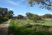
Bold Park is an extensive area of natural environment, parklands and bush, bounded by Oceanic Drive, West Coast Highway, Perry Lakes Drive and Rochdale Road, totalling 437 hectares and is the largest remaining bushland within the urban area of the Swan Coastal Plain. The portion of land to the south of Rochdale Road bordered by West Coast Highway to the west can be considered part of the original landholding and its physical form, fauna and flora are consistent with Bold Park. A further section of Bold Park is found to the north of Oceanic Drive, extending along Bold Park Drive and bordered by The Boulevard to the north and Kalinda Drive (not including the International School site or the Town of Cambridge Administration Centre). The park contains a number of features including Camel Lake, Pine Plantation, Reabold Hill and various heritage trails and nature walks and together with a number of lookouts providing long views across the City and out towards the Indian Ocean. The park also contains Perry House built in the early 1900s for the caretaker of the park (see separate entry). The parcel of land south of Rochdale Road is more informal in nature with no facilities such as graded paths or signage.
The area now defined as Bold Park has been registered as Aboriginal Site place 20178 and recognised for the following associations; historical, mythological, camp, hunting place, plant resource, and lookout point. Following the foundation of Perth in August 1829, the townsite was laid out between Mount Eliza and what was to later become Heirisson Island. Limestone was in great demand for construction in the new colony. The earliest lime kilns in Western Australia were established at the initial settlement sites of Fremantle and Albany in the 1830s, where settlers had access to local supplies of limestone. Henry Trigg, a carpenter and master builder from Gloucester, England arrived in the new colony of Western Australia in 1829. In I 834, Trigg was granted 500 acres of land, which lay south of modern day Grantham Street, stretching from Floreat to the coastal sand hills. The western boundary of Trigg's land ran along the top of a limestone ridge. As a builder, Trigg recognised the value of this limestone outcropping and set up a quarrying and lime burning business. Trigg's business which became known as the 'Limekilns' prospered. In 1839, Trigg purchased neighbouring land to the south, including what is now Perry Lakes and One Tree Hill, (now known as Reabold Hill). In the same year, Trigg was appointed Superintendent of Public Works, and in this role was responsible for overseeing the erection of many early government buildings in Perth. In 1844, Walter Padbury, a pastoralist, acquired 426 acres of land adjacent to Trigg's property and later purchased Trigg's land including the Limekilns business for 2350, forming a 1,234 acre landholding which became known as the 'Limekilns Estate'. For the next 20 years Padbury built the Estate into a successful property, including the retention of the quarrying operations. At the height of operations, more than 50 men were employed at the quarry and lime kiln site. In 1869, brothers Henry and Somers Birch purchased the Limekilns Estate from Walter Padbury for £1,000. On 1 November 1875, during their ownership of the property, the explorer Ernest Giles arrived in Perth after his 2,500 mile journey from Port Augusta. His camels were rested at the Limekilns Estate and later in the 1890s, the Limekilns Estate served as a temporary quarantine station for camels imported to Western Australia to provide transport to the goldfields, with a lake now within Bold Park becoming known as Camel Lake. The Estate remained in the Birch's ownership until, 1880 when it was purchased by Joseph Perry for the sum of £1300. During his ownership, Perry kept the Quarry and limekilns in operation. Many of Perth's early public buildings, including the foundations of the Perth Town Hall (1870) were constructed using limestone from the quarry and kilns. In 1880, a portion of the Limekilns property was rented to Charles Ball who offered to supply lime which was described as the most superior in the colony, from lime kilns of 30 years standing. Private quarrying ceased operation in 1906 and the Limekilns Quarry (Quarry Amphitheatre) remained disused for many years. Changes to the rural nature of the area came about with the subdivision of land owned by the Catholic Church in 1911. This subdivision was called the Church Lands Estate, and the first house was constructed in 1912. In 1917, the Perth City Council purchased the 1290-acre Limekilns Estate from Perry for £18,000 and it linked to the Endowment Lands bestowed on the Perth City Council by the State Government in 1902. In January 1918, the Limekilns Estate was included within the boundaries of the City of Perth, and adjoined a further 2281 acres of Endowment Lands. The City envisioned opening out the quarries and using the limestone in the construction of city roads but also setting a portion of the land aside for a public park on the site of Perry's couch paddock and One Tree Hill (Reabold Hill). The exact date that the municipal Quarry ceased operation is not known, but it is likely that operations ceased in the 1920s with the beginning of the development of the area for housing. During the middle decades of the 20th century the quarry was unused and largely inaccessible. In 1919, One Tree Hill was renamed Reabold Hill after F. R Rea, the Mayor of Perth at the time the property was acquired by the City of Perth and W. E. Bold, the town clerk. By this time the lone Tuart tree that had previously sat atop the 286 ft. high hill, and given the place its name had disappeared. In 1925, an area of land of approximately 1000 acres was set aside as a place of recreation and was the early 1900s in response to improving residential amenities for workers in nineteenth century industrial cities. The definition of a Garden City as a town designed for healthy living, surrounded by a rural belt of land owned or held in trust for the community directly influenced the planning of Floreat Park and City Beach as two satellite towns separated by a belt of undeveloped land (Bold Park). Other sources have designated that the naming occurred in 1936. Over the years, the City of Perth maintained Bold Park and Reabold Hill as places of recreation. By the 1960s, the area was surrounded by suburban housing. In 1987, the Friends of Bold Park Bushland Inc. was established to protect and conserve the park. Their role as a lobby group was significant in the decision to declare Bold Park an A-class reserve on 10 August 1998 for its high conservation, landscape and recreation values and vested with the Botanic Gardens and Parks Authority for management. Volunteers from the group work on regeneration projects, raise community awareness and provide free guided walks through the bushland. The Western Australian Ecology Centre is located on Perry Lakes Drive, City Beach. Bold Park visitor information is displayed at the building entry. Officially opened in August 2004, the Western Australian Ecology Centre was initiated as a key strategy in the inaugural Bold Park Environmental Management Plan 2000-2005 to provide a venue to assist community groups, environmental practitioners and educators to undertake their activities, and to provide office space for staff involved in Bold Park's ongoing management. The park continues to be used for passive recreation with walk paths, playgrounds and activities for a wide range of community members. The parcel of land south of Rochdale Road which has a similar physical form and historical use has not been developed by the Town of Cambridge.
Integrity: High Authenticity: High
| Ref ID No | Ref Name | Ref Source | Ref Date |
|---|---|---|---|
| Botanic Gardens and Parks Authority | Website | 2016 | |
| Aerial photographs, Landgate. | Online Reference | 1953-2016 | |
| M McCotter;"Bold Park and Environs: Public Environmental Review (Draft)". | City of Perth | Jan 1993 |
| Reserve | Lot/Location | Plan/Diagram | Vol/Folio |
|---|---|---|---|
| 3000 | Plan 54590 | 3166-564 | |
| 12965 | Plans 21069 | 311-271 | |
| 12968 | Plan 90078 | 3111-274 |
| Owner | Category |
|---|---|
| Town of Cambridge | Local Gov't |
This information is provided voluntarily as a public service. The information provided is made available in good faith and is derived from sources believed to be reliable and accurate. However, the information is provided solely on the basis that readers will be responsible for making their own assessment of the matters discussed herein and are advised to verify all relevant representations, statements and information.
165-167 Perry Lakes Dr City Beach
Cambridge
Metropolitan
Constructed from 1919
| Type | Status | Date | Documents |
|---|---|---|---|
| Heritage List | Adopted | 27 Nov 2018 |
| Type | Status | Date | Documents |
|---|---|---|---|
| (no listings) |
| Type | Status | Date | Grading/Management | |
|---|---|---|---|---|
| Category | ||||
| Municipal Inventory | Adopted | 27 Nov 2018 | Category 2 | |
| Municipal Inventory | Adopted | 17 Dec 1996 | ||
04499 Bold Park
Individual Building or Group
| Epoch | General | Specific |
|---|---|---|
| Present Use | EDUCATIONAL | Office or Administration Bldg |
| Original Use | RESIDENTIAL | Single storey residence |
| Type | General | Specific |
|---|---|---|
| Wall | BRICK | Common Brick |
| Roof | TILE | Ceramic Tile |
| Wall | STONE | Other Stone |
| General | Specific |
|---|---|
| DEMOGRAPHIC SETTLEMENT & MOBILITY | Settlements |
This information is provided voluntarily as a public service. The information provided is made available in good faith and is derived from sources believed to be reliable and accurate. However, the information is provided solely on the basis that readers will be responsible for making their own assessment of the matters discussed herein and are advised to verify all relevant representations, statements and information.
Constructed from 1919
04499 Bold Park
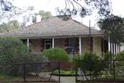
The place has aesthetic value as a good. largely intact example of a Federation Bungalow residence built in stone, brick and iron. The place has historic value for its association with the commitment by the City of Perth to manage the large landholding, known as the Endowment Lands as future parklands. The place has historic value for its association with innovative and influential City of Perth Town Clerk, William Ernest Bold who developed the plan to retain these large parklands and oversee their management. The place has social value as an illustration of government housing for a skilled tradesman and his family in the early 20th century when this locality would have been a remote posting. The place has social value for the members of the Volunteer groups which now occupy the premises which provide a service to the wider community.
Single storey brick and stone house with hipped terracotta tiled roof and surrounding verandah to three sides of the former house. The house has a semi-elevated position with brick steps leading up to the verandah. The façade is of symmetrical presentation with a centrally placed entrance door with fanlight flanked by single timber framed sash windows. All openings and the corner edges of the elevations are enlivened by brick quoining. The red brickwork has been finished with tuck-pointing whilst the stone element of the construction has been skimmed with plaster and scored with tuck pointing to look like dressed stone. The side and rear elevations have been altered by way of brick additions within the verandah line and present with a lower level of authenticity than the façade.
Perry House was built by the Perth City Council in 1919 following the purchase of the Limekilns Estate from Joseph Perry (c1841-1920) in 1917. The house was constructed for the caretaker of the Endowment Lands adjacent to the site of Perry's earlier house and stone from this building was incorporated into the new structure Remnants of the earlier building and associated structures were evident at the site in 1996. The duties of the caretaker were described in an advertisement for the position in January 1919. "Caretaker required for the City Endowment Lands and Limekilns Estate, to attend to depasturing of stock prevent removal of timber, keep fences in order, protect property of the Council, and generally act as Caretaker of the Estate, at £3 per week and quarters. Apply stating age, experience, and enclosing copies of testimonials to the Town Clerk Perth." The Town Clerk designated in the advertisement was William Ernest Bold who was a driving force in the establishment of the parks within this area. Bold was one of the State's leading advocates of the Garden City Movement, which had developed in the United Kingdom in the early 1900s to improve residential amenities for workers in nineteenth century industrial cities. The definition of a Garden City as a town designed for healthy living, surrounded by a rural belt of land owned or held in trust for the community directly influenced the planning of Floreat Park and City Beach as two satellite towns separated by a belt of undeveloped land (Bold Park). The building continued to be used as the caretaker's premises for many decades and is now the premises for volunteer groups; Friends of Bold Park Bushland, Wildflower Society of WA and Birdlife Australia. The form and extent of the building have not been significantly altered since the mid 20th century. The date of the enclosure of the verandahs has not been determined.
Integrity - moderate Authenticity - moderate
Good
| Ref ID No | Ref Name | Ref Source | Ref Date |
|---|---|---|---|
| PROWA Acc 3054, PCC File 253/1925 | Departmental File held by State Records Office | 1925 | |
| Wise's Post Office Directories for the City of Perth | Online Reference Documents | 1910-1949 | |
| Aerial photographs, Landgate. | Online Reference | 1953-2016 | |
| The Daily News, p.1. | Newspaper | 20 January 1919 |
| Reserve | Lot/Location | Plan/Diagram | Vol/Folio |
|---|---|---|---|
| 12965 | 21069 | LR3111-271 |
| Owner | Category |
|---|---|
| Town of Cambridge | Local Gov't |
This information is provided voluntarily as a public service. The information provided is made available in good faith and is derived from sources believed to be reliable and accurate. However, the information is provided solely on the basis that readers will be responsible for making their own assessment of the matters discussed herein and are advised to verify all relevant representations, statements and information.
9 Pindari Rd City Beach
Cambridge
Metropolitan
Constructed from 1964
| Type | Status | Date | Documents |
|---|---|---|---|
| Heritage List | Adopted | 27 Nov 2018 |
| Type | Status | Date | Documents |
|---|---|---|---|
| (no listings) |
| Type | Status | Date | Grading/Management | |
|---|---|---|---|---|
| Category | ||||
| Municipal Inventory | Adopted | 27 Nov 2018 | Category 3 | |
| Name | Type | Year From | Year To |
|---|---|---|---|
| Raymond Jones | Architect | - | - |
| Library Id | Title | Medium | Year Of Publication |
|---|---|---|---|
| 10193 | Modern Houses: Architect designed houses in Western Australia 1950 tpp 1960. | Book | 1997 |
| 10150 | Raymond Jones Architecture: Part 1 - An overview. | Electronic | 2013 |
| 10151 | Raymond Jones Architecture: Part 2 - Raymond's Houses 1957 -1967 | Electronic | 2013 |
Individual Building or Group
| Epoch | General | Specific |
|---|---|---|
| Original Use | RESIDENTIAL | Single storey residence |
| Present Use | RESIDENTIAL | Single storey residence |
This information is provided voluntarily as a public service. The information provided is made available in good faith and is derived from sources believed to be reliable and accurate. However, the information is provided solely on the basis that readers will be responsible for making their own assessment of the matters discussed herein and are advised to verify all relevant representations, statements and information.
Constructed from 1964 to 1970
The place has aesthetic value as an intact example of the late 20th century organic style and as a landmark in the streetscape. The place has historic value for its association with prominent architect, Raymond Jones who was influential in Western Australian practice for his non traditional approach to design and materials. The place has historic value for its association with the early 1970s which was characterised as a period of affluence which was teamed with a willingness to experiment with new styles and materials.
A two storey house situated in an elevated position on the west side of Pindari Road. The house is highly distinctive, constructed in an almost complete donut shape, with a central garden in the void. The house is of painted brick construction with a flat roof, the brick walls enlivened by an abundance of windows that advocated cross ventilation as a natural cooling process. In contrast to the stark white of the main house, the garage is of rock faced stone construction which abuts the main house creating a completely private inner garden behind. The windows are mainly large openings and are a major feature of the aesthetic qualities of the building. The main windows are three panes high and three to four panes wide, occupying great sections of the wall. Shade is provided by a small overhanging canopy. The house is positioned on an elevated site with lawns to the front.
The suburb of City Beach had sporadic and modest development until the 1960s. The 1962 Empire Games in Perth which saw the development of lands in Perry Lakes for Games Village Houses led to adjacent landholdings being released for residential subdivision. The subdivisions alongside the coast in City Beach were largely created in the late 1960s. The subdivision of City Beach on which this property is located was approved for subdivision in 1958. By 1965, there was some development of the lots and the nearby City Beach Primary School had been built. By 1974, this lot and the majority of the surrounding lots had been built on. This residence was designed by architect, Raymond Alfredo Daniel Jones (1925- ), born in Geelong Victoria he trained at the University of Melbourne after serving with the Australian Navy during World War Two. He was particularly influenced by the works of Robin Boyd and as reflected in the spatial continuity between building and landscape, as well as his environmental design philosophy. Jones relocated to Western Australia in the 1950s and was an influential practitioner through the works of his own practice and as a mentor. He had ongoing interests and passions in ecological design, through the use of skillion roofing and courtyard spaces as well as passive ventilation and site orientation. Jones is also attributed to the innovative use of concrete raft slabs and swimming pools to suburban housing, in controlling interior temperatures. This residence built in the late 1960s although designed in 1964 is identified as the Lisle home in the list of notable projects prepared for a retrospective exhibition in 2011. No details of the owners/occupants, the Lisles has been found in the current research. Since construction there has been little change to the form or extent of the residence although the asbestos roof cladding has been removed and replaced by colorbond.
Integrity: High Authenticity: High
Good
| Name | Type | Year From | Year To |
|---|---|---|---|
| Raymond Jones | Architect | 1964 | 1970 |
| Ref ID No | Ref Name | Ref Source | Ref Date |
|---|---|---|---|
| Ahead of the Pack in Architectural Thinking, ABC News, | Online Document | 29 March 2011. | |
| Goad, Philip; Willis, Julie [eds] The Encyclopaedia of Australian Architecture, Cambridge University Press. | Book | 2012 | |
| Aerial photographs, Landgate | Online Resources | 1953-2016 |
| Reserve | Lot/Location | Plan/Diagram | Vol/Folio |
|---|---|---|---|
| 609 | Plan 7094 | 1309-302 |
| Owner | Category |
|---|---|
| Private owners | Other Private |
This information is provided voluntarily as a public service. The information provided is made available in good faith and is derived from sources believed to be reliable and accurate. However, the information is provided solely on the basis that readers will be responsible for making their own assessment of the matters discussed herein and are advised to verify all relevant representations, statements and information.
Templetonia Cr City Beach
Bound by Dampier Avenue, Templetonia Crescent, The Boulevard, Lowanna Way and West Coast Highway
Bush Forever Site 310
Cambridge
Metropolitan
| Type | Status | Date | Documents |
|---|---|---|---|
| (no listings) |
| Type | Status | Date | Documents |
|---|---|---|---|
| (no listings) |
| Type | Status | Date | Grading/Management | |
|---|---|---|---|---|
| Category | ||||
| Municipal Inventory | Adopted | 27 Nov 2018 | Category 4 | |
Urban Park
| Epoch | General | Specific |
|---|---|---|
| Original Use | PARK\RESERVE | Park\Reserve |
| Present Use | PARK\RESERVE | Park\Reserve |
| General | Specific |
|---|---|
| SOCIAL & CIVIC ACTIVITIES | Sport, recreation & entertainment |
This information is provided voluntarily as a public service. The information provided is made available in good faith and is derived from sources believed to be reliable and accurate. However, the information is provided solely on the basis that readers will be responsible for making their own assessment of the matters discussed herein and are advised to verify all relevant representations, statements and information.
The place has aesthetic value as an area of largely indigenous plant species that accessible to the community which is consistent with the landscapes in adjacent public spaces. The place has historic value for its association with the development of City Beach in the 1960s and demonstrates the earlier path of The Boulevard. The place has social value as a locality of passive recreation for the community. The place has potential research value as study of its regenerated native species, as a Bush Forever Site may provide guidance for other cleared localities in a harsh environment.
Templetonia Park is a park predominantly of bushland bound by The Boulevard, West Coast Highway, Lowanna Way, Dampier Avenue and Templetonia Crescent. The park is mainly open grass interspersed with a few mature trees and native bushland. A small children’s play area is located towards the western boundary of the site. The park extends along The Boulevard westwards to West Coast Highway and forms part of the green edge to the highway.
This portion of City Beach was largely developed in the 1960s. As part of the development the alignment of The Boulevard was changed to create a straight line to the coast. The former alignment of The Boulevard forms one of the tracks through the park. At the time of the residential subdivisions nearby in the mid 1960s, aerial photographs show the park as a cleared sandy area. Regeneration of the park with native species has slowly occurred with little apparent intervention. The children's playground was built in the early 1990s although the grassed area had been established previously. The park is designated as a Bush Forever Site.
Integrity: High Authenticity: High
Good
| Ref ID No | Ref Name | Ref Source | Ref Date |
|---|---|---|---|
| Aerial photographs, Landgate | Online Resources | 1953-2016 |
| Reserve | Lot/Location | Plan/Diagram | Vol/Folio |
|---|---|---|---|
| 6000 | Plan 74241 | 2801-298 |
| Owner | Category |
|---|---|
| Town of Cambridge | Local Gov't |
This information is provided voluntarily as a public service. The information provided is made available in good faith and is derived from sources believed to be reliable and accurate. However, the information is provided solely on the basis that readers will be responsible for making their own assessment of the matters discussed herein and are advised to verify all relevant representations, statements and information.
25 Templetonia Cr City Beach
Cambridge
Metropolitan
Constructed from 1966 to 1967
| Type | Status | Date | Documents |
|---|---|---|---|
| Heritage List | Adopted | 27 Nov 2018 |
| Type | Status | Date | Documents |
|---|---|---|---|
| (no listings) |
| Type | Status | Date | Grading/Management | |
|---|---|---|---|---|
| Category | ||||
| Local Heritage Survey | Adopted | 15 Dec 2020 | Category 3 | |
| Municipal Inventory | Adopted | 27 Nov 2018 | Category 3 | |
| Anglican Church Inventory | YES | 31 Jul 1996 | ||
Individual Building or Group
| Epoch | General | Specific |
|---|---|---|
| Original Use | RELIGIOUS | Church, Cathedral or Chapel |
| Original Use | RELIGIOUS | Housing or Quarters |
| Present Use | RELIGIOUS | Church, Cathedral or Chapel |
| Type | General | Specific |
|---|---|---|
| Roof | ASBESTOS | Fibrous Cement, corrugated |
| Wall | BRICK | Common Brick |
| General | Specific |
|---|---|
| SOCIAL & CIVIC ACTIVITIES | Religion |
This information is provided voluntarily as a public service. The information provided is made available in good faith and is derived from sources believed to be reliable and accurate. However, the information is provided solely on the basis that readers will be responsible for making their own assessment of the matters discussed herein and are advised to verify all relevant representations, statements and information.
Constructed from 1967
The church has aesthetic value as a good intact example of the post war International style executed in brick that is set within its original landscaped setting. St Christopher's Anglican Church complex of buildings are a landmark in the streetscape for their continuity of presence in the community since the development of the suburb on this elevated site. The church has historic value for its association with the establishment and development of City Beach in the 1960s. The place has historic value for its association with the provision of services to the Anglican and wider community since 1967. The place has social value for the members of the City Beach and wider community who have attended the place for social and religious events since 1967.
St Christopher’s Anglican Church is set back from Templetonia Crescent, on top of a grassy embankment and partially obscured from clear view by a brick wall and trees. Due to the layout of the area, the church has an angled relationship with Templetonia Crescent. The building is single storey to the principal façade and is of brick construction painted white. The entrance is set behind a small section of covered driveway. The presentation is simple, reflective of the era of development and contains sections of blank brick walls. The butterfly roof of the south west corner makes a feature element of the building. The Tamala Road elevation is elevated, built on brick retaining with a dog leg staircase to the entrance doors. The main section of elevation is a rendered blank wall enlivened only the Church signage and flanked by recessed windows. The roof to the main section of the building is a shallow pitch gable roof, with skillion canopies to Templetonia Crescent elevation and to the rear. The church is positioned to the rear of lawned gardens with flower beds, shrubbery and trees. Vehicular access to the front entrance is via an informal grassed driveway accessed from Yalgun Road with the main access from the car park to Tamala Road.
City Beach underwent significant development in the early 1960s following subdivision of the area for residential occupation. The 1962 Empire, or Commonwealth, Games in Perth and the main stadium at Perry Lakes was a major influence on the development of the area. This area of City Beach was subdivided for residential development in 1958. Aerial photographs indicate there was little development in the vicinity until the intense building of the early 1960s. The Anglican Church built the first stage of this church c1967 and it has been extended and developed in several programs of work since then. The architect and builder of the church buildings have not been determined in this research. The driving force of the establishment of the new church in City Beach is understood to be Canon Jack Watts who joined the Anglican parish of Wembley in 1952. He oversaw the construction of the new St Edmunds Church in Wembley and established St Nicholas Church in Floreat as well as St Christopher's Church in City Beach. The rectory was built in 2003. A garden of remembrance was established in 1985 and consecrated by the Assistant Bishop of Perth, M. B. Challen.
Integrity: High Authenticity: High
Good
| Ref ID No | Ref Name | Ref Source | Ref Date |
|---|---|---|---|
| Town of Cambridge, Local History Collection, Cambridge Notes, item T222 | Online Document | ||
| St Christopher's Anglican Church City Beach, | Website | ||
| Aerial photographs, Landgate. | Online Reference | 1953-2016 |
| Reserve | Lot/Location | Plan/Diagram | Vol/Folio |
|---|---|---|---|
| 187 | Plan 31498 | 2525-518 |
| Owner | Category |
|---|---|
| Anglican Diocese | Church Property |
This information is provided voluntarily as a public service. The information provided is made available in good faith and is derived from sources believed to be reliable and accurate. However, the information is provided solely on the basis that readers will be responsible for making their own assessment of the matters discussed herein and are advised to verify all relevant representations, statements and information.
33 Templetonia Cr City Beach
Cambridge
Metropolitan
| Type | Status | Date | Documents |
|---|---|---|---|
| (no listings) |
| Type | Status | Date | Documents |
|---|---|---|---|
| (no listings) |
| Type | Status | Date | Grading/Management | |
|---|---|---|---|---|
| Category | ||||
| Municipal Inventory | Adopted | 27 Nov 2018 | Category 4 | |
Individual Building or Group
| Epoch | General | Specific |
|---|---|---|
| Original Use | SOCIAL\RECREATIONAL | Other Community Hall\Centre |
| Style |
|---|
| Late 20th-Century International |
| Type | General | Specific |
|---|---|---|
| Roof | TILE | Terracotta Tile |
| Wall | BRICK | Painted Brick |
| General | Specific |
|---|---|
| SOCIAL & CIVIC ACTIVITIES | Community services & utilities |
This information is provided voluntarily as a public service. The information provided is made available in good faith and is derived from sources believed to be reliable and accurate. However, the information is provided solely on the basis that readers will be responsible for making their own assessment of the matters discussed herein and are advised to verify all relevant representations, statements and information.
Constructed from 1970
The Civic Centre has aesthetic value as a demonstration of late 20th century international style executed in brick and tile featuring original details. The place has historic value for its association with the establishment and development of City Beach in the 1960s and 1970s, The place has social value for members of the City Beach and wider community who have attended events and activities at this place since the 1970s.
Predominantly single storey with increased height central section. The Civic Centre is of brick construction with terracotta tiled roof. The brick is grey with decorative metal fascia's. The main entrance is located to the north east elevation, with aluminium doors protected by a port cochere allowing for a covered vehicular drop off into the building. The Templetonia Crescent elevation is divided into bays each with a full height window ensemble consisting of three panes and a solid lower panel. A deep verandah extends across the elevation with an elevated deck. The roof to the main building is hipped with and elevated centred central section. The skillion form of the verandah canopy is obscured by the deep metal fascias. The building is surrounding by car parking with two vehicular access points: one on Templetonia Crescent and the other through the gardens leading off from Yanagin Crescent.
The suburb of City Beach had sporadic and modest development until the 1960s. The 1962 British Empire and Commonwealth Games held in Perth saw the development of lands in City Beach for the Games Village Houses lead to adjacent landholdings being released for residential subdivision. The subdivisions alongside the coast in City Beach were largely created in the late 1960s. The 1960s also saw the popularity and growth of surfing and the associated ‘surf culture’. Although not new to Western Australia, surfing and beach going became more popular and were closely associated with younger generations. The late 1960s can also be seen as a period of experimentation and rejection of past practices and attitudes. It was in the context of a newly established suburb providing for a young population keen to embrace new styles and technologies. The City Beach Civic Centre was built c1970 by the City of Perth to provide for the residents and its design is consistent with the period. The architect and builder have not been determined in this research. It is noted that many local government administration centres had similar styles and details in this period. Since the construction of the Civic Centre the form and extent of the structure has not changed although internally there is likely to have modifications to accommodate current standards. The civic centre has had a range of occupants and uses since the 1970s and continues be used for community groups and activities.
Good
| Ref ID No | Ref Name | Ref Source | Ref Date |
|---|---|---|---|
| Aerial photographs, Landgate | Online Resources | 1953-2016 | |
| Town of Cambridge | Website | 2018 |
| Reserve | Lot/Location | Plan/Diagram | Vol/Folio |
|---|---|---|---|
| 620 | Plan 7094 | 1853-512 |
| Owner | Category |
|---|---|
| Town of Cambridge | Local Gov't |
This information is provided voluntarily as a public service. The information provided is made available in good faith and is derived from sources believed to be reliable and accurate. However, the information is provided solely on the basis that readers will be responsible for making their own assessment of the matters discussed herein and are advised to verify all relevant representations, statements and information.
14 Tranmore Way City Beach
Cambridge
Metropolitan
Constructed from 1970
| Type | Status | Date | Documents |
|---|---|---|---|
| Heritage List | Adopted | 27 Nov 2018 |
| Type | Status | Date | Documents |
|---|---|---|---|
| RHP - To be assessed | Current | 29 Sep 2006 |
| Type | Status | Date | Grading/Management | |
|---|---|---|---|---|
| Category | ||||
| Municipal Inventory | Adopted | 27 Nov 2018 | Category 2 | |
| Name | Type | Year From | Year To |
|---|---|---|---|
| Iwan Iwanoff | Architect | - | - |
Individual Building or Group
| Epoch | General | Specific |
|---|---|---|
| Original Use | RESIDENTIAL | Single storey residence |
| Style |
|---|
| Late 20th-Century Brutalist |
| Type | General | Specific |
|---|---|---|
| Wall | CONCRETE | Concrete Block |
| General | Specific |
|---|---|
| PEOPLE | Famous & infamous people |
| PEOPLE | Innovators |
| OCCUPATIONS | Commercial & service industries |
This information is provided voluntarily as a public service. The information provided is made available in good faith and is derived from sources believed to be reliable and accurate. However, the information is provided solely on the basis that readers will be responsible for making their own assessment of the matters discussed herein and are advised to verify all relevant representations, statements and information.
Constructed from 1970
The place has aesthetic value as an intact example of the late 20th century brutalist style and as a landmark in the streetscape. This residence and other examples of Iwanoff's work are a comprehensive and notable group of buildings which demonstrate a specific design style and period. The place has historic value for its association with prominent architect, Iwan Iwanoff who was influential in Western Australian practice for his non traditional approach to design and materials drawn from European trends. The place has historic value for its association with the early 1970s which was characterised as a period of affluence which was teamed with a willingness to experiment with new styles and materials. The place has social value as the house and others of Iwanoff's design are the source of study and interest amongst members of the community.
A single storey Iwanoff house of concrete block construction, unpainted, with skillion roof and distinctive concrete block sculpture on the façade. The façade is a contrasting image of blank concrete block and intricate sculpture with a recessed entry and twin garages at the far end. The house is set in the middle of the lot behind an open garden which emphasises the distinctive form of the house.
Iwan Nickolow Iwanoff (1919-1986) was born in Kusstendil, Bulgaria. After studying architecture in Munich at the Technische Hochschule from 1941, Iwanoff worked for Emil Freymuth with the pair winning second prize in the competition to rebuild the central area of Munich. Migrating to Australia as part of the International Refugee Organization resettlement scheme, Iwanoff and his wife arrived at Fremantle, on 2 March 1950. He worked with architecture firm Kranz and Sheldon and also Yuncken and Freeman in Melbourne. In 1963, he established his own practice, The Studio of Iwanoff. A gifted architect, Iwanoff had exceptional drawing abilities, an innovative `expressionistic’ approach to design and detailing and, above all, a conviction that architecture was an art. In 1963-86 his small office produced work of high quality, including numerous houses. He also designed shop fronts and interiors in central Perth, and one larger project, the civic administration centre and public library at Northam (1969-74). His creative use of concrete blocks is a noted feature of his work. Many of the Iwanoff residences designed in the 1960s and 1970s were in the new northern suburbs of Perth where there was often minimal surrounding development and often a clientele willing to explore new styles and techniques. This house was built in 1970, according to documentation held by the State Library of WA. No details of the owners/occupants, Murphy, have been found in this research. Aerial photographs indicate the form and extent of the house have not changed since construction although the original asbestos roof cladding was replaced in 1996 with colorbond. Two stand alone buildings have also been constructed in the rear of the lot within a landscaped back yard.
Integrity: High Authenticity: High
Good
| Name | Type | Year From | Year To |
|---|---|---|---|
| Iwan Iwanoff | Architect | 1970 | 1970 |
| Ref ID No | Ref Name | Ref Source | Ref Date |
|---|---|---|---|
| Aerial photographs, Landgate | Online Resources | 1953-2016 | |
| Duncan Richards, 'Iwanoff, Iwan (1919–1986)', Australian Dictionary of Biography, National Centre of Biography, Australian National University | Online Document | 2007 | |
| Goad, Philip; Willis, Julie 'The Encyclopaedia of Australian Architecture', Cambridge University Press, p. 357. | Book | 2012 |
| Reserve | Lot/Location | Plan/Diagram | Vol/Folio |
|---|---|---|---|
| 64 | Plan 9378 | 1582-456 |
| Owner | Category |
|---|---|
| Private owners | Other Private |
This information is provided voluntarily as a public service. The information provided is made available in good faith and is derived from sources believed to be reliable and accurate. However, the information is provided solely on the basis that readers will be responsible for making their own assessment of the matters discussed herein and are advised to verify all relevant representations, statements and information.
12 Yanagin Cr City Beach
Cambridge
Metropolitan
| Type | Status | Date | Documents |
|---|---|---|---|
| Heritage List | Adopted | 27 Nov 2018 |
| Type | Status | Date | Documents |
|---|---|---|---|
| (no listings) |
| Type | Status | Date | Grading/Management | |
|---|---|---|---|---|
| Category | ||||
| Municipal Inventory | Adopted | 27 Nov 2018 | Category 2 | |
Individual Building or Group
| Epoch | General | Specific |
|---|---|---|
| Original Use | RESIDENTIAL | Two storey residence |
| Present Use | RESIDENTIAL | Two storey residence |
| Style |
|---|
| Late 20th-Century Brutalist |
| Type | General | Specific |
|---|---|---|
| Wall | CONCRETE | Concrete Block |
| Roof | METAL | Zincalume |
| General | Specific |
|---|---|
| PEOPLE | Innovators |
This information is provided voluntarily as a public service. The information provided is made available in good faith and is derived from sources believed to be reliable and accurate. However, the information is provided solely on the basis that readers will be responsible for making their own assessment of the matters discussed herein and are advised to verify all relevant representations, statements and information.
Constructed from 1967
The place has aesthetic value as an intact example of the late 20th century brutalist style and as a landmark in the streetscape. This residence and other examples of Iwanoff's work are a comprehensive and notable group of buildings which demonstrate a specific design style and period. The place has historic value for its association with prominent architect, Iwan Iwanoff who was influential in Western Australian practice for his non traditional approach to design and materials drawn from European trends. The place has historic value for its association with the early 1970s which was characterised as a period of affluence which was teamed with a willingness to experiment with new styles and materials. The place has social value as the house and others of Iwanoff's design are the source of study and interest amongst members of the community.
A two storey Iwanoff house of concrete block construction. The activated façade is characterised by the concrete blockwork arranged in an abstract manner which shield much of the façade from clear view but still allows light into the house. Beyond the blockwork there is a high degree of glazing to the façade, a balcony to part of the upper level and a verandah to the lower level. A single storey garage to the north east corner of the house provides a private garden area for the recessed section of the house. The house is built on an elevated position which emphasises the angular nature of the design.
wan Nickolow Iwanoff (1919-1986) was born in Kusstendil, Bulgaria. After studying architecture in Munich at the Technische Hochschule from 1941, Iwanoff worked for Emil Freymuth with the pair winning second prize in the competition to rebuild the central area of Munich. Migrating to Australia as part of the International Refugee Organization resettlement scheme, Iwanoff and his wife arrived at Fremantle, on 2 March 1950. He worked with architecture firm Kranz and Sheldon and also Yuncken and Freeman in Melbourne. In 1963, he established his own practice, The Studio of Iwanoff. A gifted architect, Iwanoff had exceptional drawing abilities, an innovative `expressionistic’ approach to design and detailing and, above all, a conviction that architecture was an art. In 1963-86 his small office produced work of high quality, including numerous houses. He also designed shop fronts and interiors in central Perth, and one larger project, the civic administration centre and public library at Northam (1969-74). His creative use of concrete blocks is a noted feature of his work. Many of the Iwanoff residences designed in the 1960s and 1970s were in the new northern suburbs of Perth where there was often minimal surrounding development and often a clientele willing to explore new styles and techniques. This residence was built in 1967 for the client identified as Roberts, no detail of this occupant or owner have been found in this research. Aerial photographs indicate that the form and extent of the original building have not been altered since construction although the garage located on the northern side of the building is a later construction.
Integrity: High Authenticity: High
| Name | Type | Year From | Year To |
|---|---|---|---|
| Iwan Iwanoff | Architect | 1967 | 1967 |
| Ref ID No | Ref Name | Ref Source | Ref Date |
|---|---|---|---|
| Goad, Philip; Willis, Julie 'The Encyclopaedia of Australian Architecture', Cambridge University Press, p. 357. | Book | 2012 | |
| Duncan Richards, 'Iwanoff, Iwan (1919–1986)', Australian Dictionary of Biography, National Centre of Biography, Australian National University | Online Document | 2007 | |
| Aerial photographs, Landgate | Online Resources | 1953-2016 |
| Reserve | Lot/Location | Plan/Diagram | Vol/Folio |
|---|---|---|---|
| 613 | Plan 7094 | 1680-902 |
| Owner | Category |
|---|---|
| Private owners | Other Private |
This information is provided voluntarily as a public service. The information provided is made available in good faith and is derived from sources believed to be reliable and accurate. However, the information is provided solely on the basis that readers will be responsible for making their own assessment of the matters discussed herein and are advised to verify all relevant representations, statements and information.
4 Alyth Rd Floreat
Cambridge
Metropolitan
Constructed from 1962
| Type | Status | Date | Documents |
|---|---|---|---|
| Heritage List | Adopted | 27 Nov 2018 |
| Type | Status | Date | Documents |
|---|---|---|---|
| (no listings) |
| Type | Status | Date | Grading/Management | |
|---|---|---|---|---|
| Category | ||||
| Municipal Inventory | Adopted | 27 Nov 2018 | Category 2 | |
Individual Building or Group
| Epoch | General | Specific |
|---|---|---|
| Present Use | RESIDENTIAL | Single storey residence |
| Original Use | RESIDENTIAL | Single storey residence |
| Style |
|---|
| Late 20th-Century International |
| Type | General | Specific |
|---|---|---|
| Roof | METAL | Zincalume |
| Wall | BRICK | Painted Brick |
| General | Specific |
|---|---|
| PEOPLE | Innovators |
This information is provided voluntarily as a public service. The information provided is made available in good faith and is derived from sources believed to be reliable and accurate. However, the information is provided solely on the basis that readers will be responsible for making their own assessment of the matters discussed herein and are advised to verify all relevant representations, statements and information.
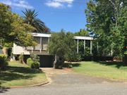
Constructed from 1962
The place has aesthetic value as an intact example of the late 20th century International style. This residence and other examples of Iwanoff's work are a comprehensive and notable group of buildings which demonstrate a specific design style and period. The place has historic value for its association with prominent architect, Iwan Iwanoff who was influential in Western Australian practice for his nontraditional approach to design and materials drawn from European trends. The place has historic value for its association with the early 1960s which was characterised as a period of affluence which was teamed with a willingness to experiment with new styles and materials. The place has social value as the house and others of Iwanoff's design are the source of study and interest amongst members of the community.
Single storey house with undercroft parking. The façade of the house is of lineal design with a frontage divided into bays created by the shade structure supports, creating a regular rhythm to the frontage of the property. The windows behind the shade structure are all full height openings. The shade structures and planting have obscured the front elevation and prevented full description of this property.
Iwan Nickolow Iwanoff (1919-1986) was born in Kusstendil, Bulgaria. After studying architecture in Munich at the Technische Hochschule from 1941, Iwanoff worked for Emil Freymuth with the pair winning second prize in the competition to rebuild the central area of Munich. Migrating to Australia as part of the International Refugee Organization resettlement scheme, Iwanoff and his wife arrived at Fremantle, on 2 March 1950. He worked with architecture firm Kranz and Sheldon and also Yuncken and Freeman in Melbourne. In 1963, he established his own practice, The Studio of Iwanoff. A gifted architect, Iwanoff had exceptional drawing abilities, an innovative `expressionistic’ approach to design and detailing and, above all, a conviction that architecture was an art. In 1963-86 his small office produced work of high quality, including numerous houses. He also designed shop fronts and interiors in central Perth, and one larger project, the civic administration centre and public library at Northam (1969-74). His creative use of concrete blocks is a noted feature of his work. Many of the Iwanoff residences designed in the 1960s and 1970s were in the new northern suburbs of Perth where there was often minimal surrounding development and often a clientele willing to explore new styles and techniques. Plans for this residence were prepared by Iwanoff’s office in 1962 for Schenberg and electoral rolls confirm that pharmacist David Schenberg and his wife Esther were living at the residence in 1963. Aerial photographs indicate a small addition has been added to at the rear of the place although the form and extent of the original construction can still be determined.
Integrity: High Authenticity: High
Good
| Name | Type | Year From | Year To |
|---|---|---|---|
| Iwan Iwanoff | Architect | 1962 | 1962 |
| Ref ID No | Ref Name | Ref Source | Ref Date |
|---|---|---|---|
| Goad, Philip; Willis, Julie 'The Encyclopaedia of Australian Architecture', Cambridge University Press | Book | 2012 | |
| Duncan Richards, 'Iwanoff, Iwan (1919–1986)', Australian Dictionary of Biography, National Centre of Biography, Australian National University | Online Document | 2007 | |
| State Library of WA, Iwan Iwanoff Collection. MN1401, Acc 4400A | Plans | ||
| Aerial photographs, Landgate. | Online Reference | 1953-2016 |
| Reserve | Lot/Location | Plan/Diagram | Vol/Folio |
|---|---|---|---|
| 1815 | Plan 7286 | 1236-761 |
| Owner | Category |
|---|---|
| Private owners | Other Private |
This information is provided voluntarily as a public service. The information provided is made available in good faith and is derived from sources believed to be reliable and accurate. However, the information is provided solely on the basis that readers will be responsible for making their own assessment of the matters discussed herein and are advised to verify all relevant representations, statements and information.
48-50 Berkeley Cr Floreat
Cnr Berkeley Crescent and Kirkdale Ave
Cambridge
Metropolitan
Constructed from 1956
| Type | Status | Date | Documents |
|---|---|---|---|
| (no listings) |
| Type | Status | Date | Documents |
|---|---|---|---|
| (no listings) |
| Type | Status | Date | Grading/Management | |
|---|---|---|---|---|
| Category | ||||
| Uniting Church Inventory | Completed | 01 Oct 1996 | ||
15020 All Saints Church and Crawford Hall
Individual Building or Group
| Epoch | General | Specific |
|---|---|---|
| Other Use | RELIGIOUS | Office or Administration Bldg |
| Original Use | RELIGIOUS | Church Hall |
| Present Use | RELIGIOUS | Church Hall |
| Present Use | RELIGIOUS | Office or Administration Bldg |
| Type | General | Specific |
|---|---|---|
| Wall | BRICK | Common Brick |
| Roof | TILE | Ceramic Tile |
| General | Specific |
|---|---|
| SOCIAL & CIVIC ACTIVITIES | Religion |
This information is provided voluntarily as a public service. The information provided is made available in good faith and is derived from sources believed to be reliable and accurate. However, the information is provided solely on the basis that readers will be responsible for making their own assessment of the matters discussed herein and are advised to verify all relevant representations, statements and information.
48 Berkeley Cr Floreat
Cambridge
Metropolitan
Constructed from 1995
| Type | Status | Date | Documents |
|---|---|---|---|
| (no listings) |
| Type | Status | Date | Documents |
|---|---|---|---|
| (no listings) |
| Type | Status | Date | Grading/Management | |
|---|---|---|---|---|
| Category | ||||
| Uniting Church Inventory | Completed | 01 Oct 1996 | ||
| Municipal Inventory | Adopted | 27 Nov 2018 | Category 4 | |
Individual Building or Group
| Epoch | General | Specific |
|---|---|---|
| Original Use | RELIGIOUS | Church, Cathedral or Chapel |
| Present Use | RELIGIOUS | Church, Cathedral or Chapel |
| Type | General | Specific |
|---|---|---|
| Roof | TILE | Ceramic Tile |
| Wall | BRICK | Common Brick |
| General | Specific |
|---|---|
| SOCIAL & CIVIC ACTIVITIES | Religion |
This information is provided voluntarily as a public service. The information provided is made available in good faith and is derived from sources believed to be reliable and accurate. However, the information is provided solely on the basis that readers will be responsible for making their own assessment of the matters discussed herein and are advised to verify all relevant representations, statements and information.
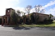
Constructed from 1953, Constructed from 1993, Constructed from 1956
The place has some aesthetic value as a landmark in the streetscape demonstrating late 20th century ecclesiastical style integrated with Crawford Hall built in the Post War style. The Church has historic value as a demonstration of the coming together of different faiths to form the Uniting Church in 1977 and subsequently building this single complex of hall and church in the parish. The place has historic value a demonstration of the growth of the community in Floreat in the post war period and the establishment of the All Saints Presbyterian Church. The place has social value as the location of many religious and social events for members of the community since 1956.
All Saints comprises a church and adjoining administration/ church hall spaces. The hall was constructed in the 1950s and has been incorporated into a late 1980s development comprising the church and bell tower. The development is set back behind a deep grass verge at the intersection of Kirkdale Avenue and Berkeley Crescent. The earlier section of the development was constructed from a combination of pale and red brick which has been carried through into the later developments creating some unity to the buildings. The church is a contemporary pale and red brick building with precast concrete panels and distinctive curved wall with integral glass cross facing the intersection. The main entrance is located along Berkeley Street underneath the belltower. The bell tower is a double height feature, constructed from the two contrasting brick types, raised hipped roof and an unglazed opening to each elevation. The church has a tiled hipped roof. The church is built behind the curved wall and is at an angle, facing the intersection of the two roads. The increased height of the church building creates delineation from the adjoining hall facilities due to the single storey link between the church and bell tower. Crawford Hall is a predominantly single storey building dating from the 1950s which due to the changing land levels incorporates a lower ground floor level at the western end. The place is of brick construction with red brick to the lower courses and pale brick to the upper two thirds. Timber framed French doors provide access to the undercroft with paired timber framed arched windows to the upper level windows. The roof is tiled, with gables to the east and west ends. The Manse is not included in this assessment.
At the inauguration of the Uniting Church in Australia on 22 June 1977, five congregations formed the Wembley-Floreat Park Parish. They were the four Methodist congregations (Wembley, ‘Forum’ of Floreat, Wembley Downs and West Leederville) plus the Floreat Park Presbyterian Church, ‘All Saints’. On 1 July 1988, the Presbytery of Perth agreed to a re-grouping of the parishes in the area and the new Parish of Floreat Park was inaugurated, with the two congregations of ‘All Saints’ in Peebles Road and the ‘Forum’ on the corner of Brookdale Street (now Kirkdale Avenue) and Berkeley Crescent becoming one congregation. After much deliberation the buildings in Peebles Road and the church in Berkeley Crescent were demolished. The decommissioning service was held on Friday 13 August, 1993. The Peebles Road property was sold and building began on the new church complex in Berkeley Crescent on the corner of Kirkdale Avenue. In May 1995, the All Saints Floreat Uniting Church was officially opened by Moderator, Lillian Hadley on the site of the Forum Uniting Church in Berkeley Crescent Floreat. The new building integrated the existing Crawford Hall which was built c1956 and included an earlier Page Room, built in 1953. The single storey brick manse located on the northern side of the site was demolished in 1995 as part of the program of works. A new two storey manse was built on the site and continues to be used as accommodation for the minister. It does not form part of this assessment.
Integrity: High Authenticity: High
Very Good
| Ref ID No | Ref Name | Ref Source | Ref Date |
|---|---|---|---|
| Aerial Photographs | Online Reference | 1953-2016 | |
| Information from All Saints Chair Council | September 2018. | ||
| The Uniting Church in Australia, Synod of Western Australia, Heritage Inventory, Volume Two, A National Estate Study, Hocking Planning & Architecture | Report | 1996 |
| Reserve | Lot/Location | Plan/Diagram | Vol/Folio |
|---|---|---|---|
| 10 | Diagram 88988 | 2198-59 |
| Owner | Category |
|---|---|
| Uniting Church of Australia | Church Property |
This information is provided voluntarily as a public service. The information provided is made available in good faith and is derived from sources believed to be reliable and accurate. However, the information is provided solely on the basis that readers will be responsible for making their own assessment of the matters discussed herein and are advised to verify all relevant representations, statements and information.
45 Berkeley St Floreat
Cambridge
Metropolitan
Constructed from 1962, Constructed from 1995
| Type | Status | Date | Documents |
|---|---|---|---|
| Heritage List | Adopted | 27 Nov 2018 |
| Type | Status | Date | Documents |
|---|---|---|---|
| (no listings) |
| Type | Status | Date | Grading/Management | |
|---|---|---|---|---|
| Category | ||||
| Local Heritage Survey | Adopted | 15 Dec 2020 | Category 2 | |
| Municipal Inventory | Adopted | 27 Nov 2018 | Category 2 | |
| Anglican Church Inventory | YES | 31 Jul 1996 | ||
Individual Building or Group
| Epoch | General | Specific |
|---|---|---|
| Original Use | RELIGIOUS | Church, Cathedral or Chapel |
| Present Use | RELIGIOUS | Church, Cathedral or Chapel |
| Present Use | RELIGIOUS | Housing or Quarters |
| Original Use | RELIGIOUS | Housing or Quarters |
| Type | General | Specific |
|---|---|---|
| Roof | TILE | Cement Tile |
| Wall | BRICK | Common Brick |
| General | Specific |
|---|---|
| SOCIAL & CIVIC ACTIVITIES | Religion |
This information is provided voluntarily as a public service. The information provided is made available in good faith and is derived from sources believed to be reliable and accurate. However, the information is provided solely on the basis that readers will be responsible for making their own assessment of the matters discussed herein and are advised to verify all relevant representations, statements and information.
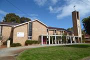
Constructed from 1962
The church has aesthetic value as a good intact example of the post war international style executed in brick and tile featuring stained glass and original internal features. The church has aesthetic value as a landmark in the street and district. The place has historic value for its association with the development of Floreat Park in the 1950s and 1960s and with the acceleration of settlement following the Empire/Commonwealth Games in 1962. The place has historic value for its identification with the sportsmen and women which reflected the enthusiasm for sports in the early 1960s when Perth held the Commonwealth Games. The place has social value for the members of the community who have attended the place for social and religious occasions since 1962.
The church was constructed in 1962 and is considered to form part of the Late Twentieth Century Ecclesiastical style, and is quite simple in its presentation. The structure benefits from a traditional vertical emphasis. The place is of brick construction with a tiled roof. A free standing tower is located to the front of the north west corner of the church. The stained glass windows are located around the building, many of which extend to the eaves, and are principally strip windows in a blank brick elevation. The north elevation to Berkeley Street consists of an asymmetric plan with one of the entries accommodated in the north wing and a second through the tower.
The Anglican Parish of St Nicholas (Floreat Park) was initially part of the St Edmund's (Wembley) Parish until designated as its own parish in 1972. At first, people from the Floreat area worshipped in the local tennis club. The parish later gathered in the first church hall which was located directly south of the church and accessed from The Boulevard (84-86 The Boulevard). The original church hall was replaced with the current church hall in 1999. Fund raising to build a church in this developing parish began in the 1950s. Melbourne Architect Louis Williams designed the church and a listing of the projects of this firm identifies the design was overseen by Associate, Bill Douglas. Louis Reginald Williams (1890-1980) was an ecclesiastical architect who designed churches throughout the country, particularly in Victoria, primarily Anglican but also Methodists, Presbyterians, Lutherans and Christian Scientists. Williams was probably the major church architect in Australia in the Arts and Crafts tradition from the 1920s to the 1970s. The church was consecrated by Archbishop of Perth, Robert Moline, on 20th October 1962 and cost £34,400. As part of the ceremony the church was 'dedicated in honour of Australian Sportsmen who have played an important role in strengthening international relationships and goodwill'. The association with Sports was heightened because the Empire or Commonwealth Games were being held in 1962 and many events at the new Perry Lakes stadium nearby. Many sporting organisations donated the jarrah pews which were chosen to blend with the jarrah flooring. It was noted in the West Australian, that enamelled plaques bearing the insignia of sporting and athletic associations are fixed to the pews of the church. In addition, England Test cricketer, the Rev David Sheppard, preached at Evensong in the new church. The church features an original organ built by Paul F. Hufner and installed in 1962. The stained glass windows were added after the church's initial construction. Archbishop Roger Herft consecrated the icons of Jesus Christ Pantocrator and St Nicholas of Myra during at the 50th anniversary of the consecration of the church building in October 2012.
Integrity: High Authenticity: High
Good
| Name | Type | Year From | Year To |
|---|---|---|---|
| Bill Douglas | Architect | 1962 | 1962 |
| Louis Williams | Architect | 1962 | 1962 |
| Ref ID No | Ref Name | Ref Source | Ref Date |
|---|---|---|---|
| The Organ Society of Western Australia, Western Australian Pipe Organs, St Nicholas Anglican Church, | Website | ||
| G.M. Moore, Louis Reginald Williams, Masters of Planning and Design, University of Melbourne, | Book | 2001 | |
| Goad, Philip; Willis, Julie [eds] The Encyclopaedia of Australian Architecture, Cambridge University Press, pp765-6. | Book | 2012 | |
| Aerial photographs, Landgate | Online Resources | 1953-2016 | |
| St Nicholas' Anglican Church Floreat Park | Website |
| Reserve | Lot/Location | Plan/Diagram | Vol/Folio |
|---|---|---|---|
| 642 | Plan 6279 | 2156-761 | |
| 641 | Plan 6279 | 2156-761 |
| Owner | Category |
|---|---|
| Anglican Diocese of Perth | Church Property |
This information is provided voluntarily as a public service. The information provided is made available in good faith and is derived from sources believed to be reliable and accurate. However, the information is provided solely on the basis that readers will be responsible for making their own assessment of the matters discussed herein and are advised to verify all relevant representations, statements and information.
39 Chandler Av Floreat
Bound by Oceanic Drive, Howtree Place, Chandler Avenue and Ulster Road
Cambridge
Metropolitan
| Type | Status | Date | Documents |
|---|---|---|---|
| (no listings) |
| Type | Status | Date | Documents |
|---|---|---|---|
| (no listings) |
| Type | Status | Date | Grading/Management | |
|---|---|---|---|---|
| Category | ||||
| Municipal Inventory | Adopted | 27 Nov 2018 | Category 4 | |
Urban Park
| Epoch | General | Specific |
|---|---|---|
| Present Use | PARK\RESERVE | Park\Reserve |
| Original Use | PARK\RESERVE | Park\Reserve |
| General | Specific |
|---|---|
| SOCIAL & CIVIC ACTIVITIES | Sport, recreation & entertainment |
This information is provided voluntarily as a public service. The information provided is made available in good faith and is derived from sources believed to be reliable and accurate. However, the information is provided solely on the basis that readers will be responsible for making their own assessment of the matters discussed herein and are advised to verify all relevant representations, statements and information.
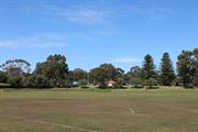
Constructed from 1950 to 1960
The place has aesthetic value as a well maintained greened landscape and sports grounds in an urban setting. The park has historic value for its association with the development of community facilities in Floreat in the 1950s. The park has social value for many members of the community as a place for organised and informal sports, passive recreation and social events since the 1950s
A large sporting space within the residential suburb of Floreat which adjoins McLean Park and forms part of a larger sporting complex which includes the Subiaco Floreat Cricket Club, tennis club and the bowling club. The Oval is surrounded by grassy banks and mature trees shielding much of the oval from clear view from Oceanic Drive and Ulster Road. A club house has been constructed on the western banks of the oval.
This portion of Floreat was subdivided for development in the period following World War II and the City of Perth were active in providing recreation facilities for the new settlers. By 1953, the adjacent Floreat Park Primary School and McLean Park to the north had been established, ground works were underway for the new oval, tennis courts and bowling greens. By 1965, the grounds and clubrooms were well established and the nearby Floreat Forum was under construction. Since that time the facilities continue to be maintained and upgraded. Currently [2017] Floreat Oval is the home ground for several local clubs including; cricket, AFL, and lacrosse. Surrounding the oval are the facilities for tennis, bowls and croquet.
Integrity: High Authenticity: High
Very Good
| Ref ID No | Ref Name | Ref Source | Ref Date |
|---|---|---|---|
| Aerial photographs, Landgate | Online Resources | 1953-2016 | |
| Town of Cambridge | Website |
| Reserve | Lot/Location | Plan/Diagram | Vol/Folio |
|---|---|---|---|
| 1752 | Plan 6153 | 1128-552 |
| Owner | Category |
|---|---|
| Town of Cambridge | Local Gov't |
This information is provided voluntarily as a public service. The information provided is made available in good faith and is derived from sources believed to be reliable and accurate. However, the information is provided solely on the basis that readers will be responsible for making their own assessment of the matters discussed herein and are advised to verify all relevant representations, statements and information.
38 Chandler Av West Floreat
Cambridge
Metropolitan
Constructed from 1956
| Type | Status | Date | Documents |
|---|---|---|---|
| Heritage List | Adopted | 27 Nov 2018 |
| Type | Status | Date | Documents |
|---|---|---|---|
| (no listings) |
| Type | Status | Date | Grading/Management | |
|---|---|---|---|---|
| Category | ||||
| Municipal Inventory | Adopted | 17 Dec 1996 | ||
| Municipal Inventory | Adopted | 27 Nov 2018 | Category 2 | |
Individual Building or Group
| Epoch | General | Specific |
|---|---|---|
| Present Use | EDUCATIONAL | Primary School |
| Original Use | EDUCATIONAL | Primary School |
| Type | General | Specific |
|---|---|---|
| Roof | TILE | Ceramic Tile |
| Wall | BRICK | Common Brick |
| General | Specific |
|---|---|
| SOCIAL & CIVIC ACTIVITIES | Education & science |
This information is provided voluntarily as a public service. The information provided is made available in good faith and is derived from sources believed to be reliable and accurate. However, the information is provided solely on the basis that readers will be responsible for making their own assessment of the matters discussed herein and are advised to verify all relevant representations, statements and information.
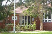
Constructed from 1982, Constructed from 1964, Constructed from 1950, Constructed from 1956, Constructed from 2010
The place has aesthetic value as a largely intact example of a Post World War II complex of educational buildings that feature the style and detail of the period. The place has historic significance for its association with the settlement of Floreat and the provision of education to the community of Floreat Park. The place has social value for the members of the local community, particularly past students and staff.
Floreat Park Primary School is located to the west of Howtree Place and south of The Boulevard, two of the main roads running through the suburb. The school is of traditional design displaying many features of academic architecture of the 1950s including brick and render construction with terracotta tiled roofs. The school is mainly single storey though sections of the buildings do incorporate a lower level to take account of the changing land levels across the site. The lower sections of the elevations are face brick with the upper sections rendered. Windows are multi-paned timber framed sash openings. The roofs are hipped with tall white painted brick chimneys, it is unknown whether the traditional fireplaces still remain extant inside the class rooms. The school is arranged in a series of ranges around an enclosed court yard, new development has occurred to the north western corner of the site and the oval/sports field is located to the west of the main school buildings.
Departmental action on the construction of Floreat Park Primary School was initiated in December 1948, when it was considered that a six roomed school would meet the district’s educational requirements for a considerable period of time. Planning for Floreat Park Primary School began when expenditure was approved by State Government for a new school on 22nd February 1949 at a cost of £28,000. In January 1951, the school was opened for the first enrolments and an item in the local press described the new school as follows: 'The building consists of five classrooms, a headmaster's room, medical room, stores and large library. An undercroft has been used to provide lavatories, cloakrooms and shelters. In designing the school particular attention was paid to natural lighting, ventilation and acoustics. The class rooms are considerably larger than the old-type to provide space for the new tubular school furniture.' By the time of completion the school was already too small for the demands for enrolment. In 1953, 4 prefabricated classrooms were added and within a further 12 months, another 4 prefabricated classrooms were added and two brick classrooms were built. In 1955, a verandah was constructed on the north-eastern side of one of the units for protection from the sun. Since the 1950s, the school buildings and facilities have been added to or modified as the population has changed and in accordance with changing education practices. A common practice over the decades has been the addition and removal of transportable classrooms when the school population changed. Recent changes include in 2009 the addition of two classrooms and a music and art block, while the existing buildings were upgraded and a new shade structure was built. In 2011 and 2016, more classrooms were added to serve the growing population in the area and a specialised early childhood education building was constructed on site.
Integrity: High Authenticity: High
Good
| Ref ID No | Ref Name | Ref Source | Ref Date |
|---|---|---|---|
| The West Australian, p. 11 | Newspaper | 11 January 1951 | |
| Aerial Photographs | Landgate | 1953-2016 | |
| Floreat Park Primary School | Website | 2016 | |
| WABMA Heritage Database | Report |
| Reserve | Lot/Location | Plan/Diagram | Vol/Folio |
|---|---|---|---|
| 8498 | Plan 6135 | 2649-557 |
| Owner | Category |
|---|---|
| Education Department | State Gov't |
This information is provided voluntarily as a public service. The information provided is made available in good faith and is derived from sources believed to be reliable and accurate. However, the information is provided solely on the basis that readers will be responsible for making their own assessment of the matters discussed herein and are advised to verify all relevant representations, statements and information.
32 Donegal Rd Floreat
Toschkoff Residence
Cambridge
Metropolitan
Constructed from 1959
| Type | Status | Date | Documents |
|---|---|---|---|
| Heritage List | Adopted | 27 Nov 2018 |
| Type | Status | Date | Documents |
|---|---|---|---|
| (no listings) |
| Type | Status | Date | Grading/Management | |
|---|---|---|---|---|
| Category | ||||
| Municipal Inventory | Adopted | 27 Nov 2018 | Category 2 | |
Individual Building or Group
| Epoch | General | Specific |
|---|---|---|
| Present Use | RESIDENTIAL | Single storey residence |
| Original Use | RESIDENTIAL | Single storey residence |
| Style |
|---|
| Late 20th-Century International |
| Type | General | Specific |
|---|---|---|
| Wall | BRICK | Painted Brick |
| Roof | METAL | Zincalume |
| General | Specific |
|---|---|
| PEOPLE | Innovators |
This information is provided voluntarily as a public service. The information provided is made available in good faith and is derived from sources believed to be reliable and accurate. However, the information is provided solely on the basis that readers will be responsible for making their own assessment of the matters discussed herein and are advised to verify all relevant representations, statements and information.
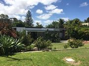
Constructed from 1958
The place has aesthetic value as an intact example of the late 20th century international style and as a landmark in the streetscape. This residence and other examples of Iwanoff's work are a comprehensive and notable group of buildings which demonstrate a specific design style and period. The place has historic value for its association with prominent architect, Iwan Iwanoff who was influential in Western Australian practice for his non traditional approach to design and materials drawn from European trends. The place has historic value for its association with the late 1950s to the 1970s which was characterised as a period of affluence which was teamed with a willingness to experiment with new styles and materials. The place has social value as the house and others of Iwanoff's design are the source of study and interest amongst members of the community.
Single storey brick and stone house with flat, or very shallow pitched, roof. The front of the house is characterised by the full height windows positioned to either end of the elevation with the centre of the façade being dominated by a random stone wall which supports a flat roof verandah canopy.
Iwan Nickolow Iwanoff (1919-1986) was born in Kusstendil, Bulgaria. After studying architecture in Munich at the Technische Hochschule from 1941, Iwanoff worked for Emil Freymuth with the pair winning second prize in the competition to rebuild the central area of Munich. Migrating to Australia as part of the International Refugee Organization resettlement scheme, Iwanoff and his wife arrived at Fremantle, on 2 March 1950. He worked with architecture firm Kranz and Sheldon and also Yuncken and Freeman in Melbourne. In 1963, he established his own practice, The Studio of Iwanoff. A gifted architect, Iwanoff had exceptional drawing abilities, an innovative `expressionistic’ approach to design and detailing and, above all, a conviction that architecture was an art. In 1963-86 his small office produced work of high quality, including numerous houses. He also designed shop fronts and interiors in central Perth, and one larger project, the civic administration centre and public library at Northam (1969-74). His creative use of concrete blocks is a noted feature of his work. Many of the Iwanoff residences designed in the 1960s and 1970s were in the new northern suburbs of Perth where there was minimal surrounding development and often a clientele willing to explore new styles and techniques. This residence was designed in 1958 and the plans held by the Town of Cambridge do not designate the architect or designer of the residence. Information from the current owner states that the residence was built for Bulgarian migrant Dimiter Toschkoff (1919-2003) and his wife Rita. The Toschkoffs were friends of Iwanoff and shared their country of origin. Dimiter (Jim) Toschkoff arrived in the Western Australia in 1950, the same year as Iwanoff, and possibly through the same International Refugee Organization resettlement scheme. The electoral rolls for 1958 show that Toschkoff recorded his occupation as a draughtsman. It is possible that Jim Toschkoff designed the residence whilst working for Iwanoff or at least under the guidance of his friend Iwanoff prior to the later establishment of 'The Studio of Iwanoff'. In later years, Rita Toschkoff assisted Iwanoff by driving him around Perth to his various projects. Aerial photographs show the place has changed minimally in form and extent since its construction in the late 1950s.
Integrity: High Authenticity: High
Very Good
| Name | Type | Year From | Year To |
|---|---|---|---|
| Iwan Iwanoff | Architect | 1958 | 1958 |
| Ref ID No | Ref Name | Ref Source | Ref Date |
|---|---|---|---|
| State Library of WA, Iwan Iwanoff Collection. MN1401, Acc 4400A | Plans | ||
| Aerial photographs, Landgate | Online Resources | 1953-2016 | |
| Duncan Richards, 'Iwanoff, Iwan (1919–1986)', Australian Dictionary of Biography, National Centre of Biography, Australian National University | Online Document | 2007 | |
| Goad, Philip; Willis, Julie [eds] The Encyclopaedia of Australian Architecture, Cambridge University Press. p.357. | Book | 2012 |
| Reserve | Lot/Location | Plan/Diagram | Vol/Folio |
|---|---|---|---|
| 1330 | Plan 6371 | 1627-767 |
| Owner | Category |
|---|---|
| Private owners | Other Private |
This information is provided voluntarily as a public service. The information provided is made available in good faith and is derived from sources believed to be reliable and accurate. However, the information is provided solely on the basis that readers will be responsible for making their own assessment of the matters discussed herein and are advised to verify all relevant representations, statements and information.