Local Government
Cambridge
Region
Metropolitan
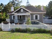
5 Howtree Pl Floreat
Cambridge
Metropolitan
Constructed from 1963 to 1964
| Type | Status | Date | Documents |
|---|---|---|---|
| (no listings) |
| Type | Status | Date | Documents |
|---|---|---|---|
| (no listings) |
| Type | Status | Date | Grading/Management | |
|---|---|---|---|---|
| Category | ||||
| Municipal Inventory | Adopted | 27 Nov 2018 | Category 4 | |
| Municipal Inventory | Adopted | 17 Dec 1996 | ||
| Name | Type | Year From | Year To |
|---|---|---|---|
| Cameron, Chisholm & Nicol | Architect | - | - |
Individual Building or Group
| Epoch | General | Specific |
|---|---|---|
| Original Use | COMMERCIAL | Shopping Complex |
| Present Use | COMMERCIAL | Shopping Complex |
| Type | General | Specific |
|---|---|---|
| Wall | CONCRETE | Pre-cast concrete panel |
| Roof | OTHER | Other Material |
| General | Specific |
|---|---|
| OCCUPATIONS | Commercial & service industries |
This information is provided voluntarily as a public service. The information provided is made available in good faith and is derived from sources believed to be reliable and accurate. However, the information is provided solely on the basis that readers will be responsible for making their own assessment of the matters discussed herein and are advised to verify all relevant representations, statements and information.
Constructed from 1964, Constructed from 1963
The place has historic value as the first example of the 'American Style' enclosed shopping mall in metropolitan Perth. The place has aesthetic value as a landmark in the district which is visible from many directions as it is located at a junction of several major roads. The place has social value to the members of the community as it has been a popular and successful retail complex and venue for social gatherings since 1965.
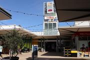
The centre is single storey construction with stores facing into open walkways and a covered shopping centre. The centre has an inward character with blank elevation to Howtree Place and all the activation taking place within the centre. An active frontage is visible from Floreat Avenue which also provides access into the roof top car park
Floreat Forum shopping centre was constructed throughout 1963 to 1965 and opened by Premier David Brand on 20 September 1965. The adjacent suburbs underwent significant development in the early 1960s, particularly following the Commonwealth Games at Perry Lakes in 1962. Originally the centre featured a distinctive conical roof structure which covered the first enclosed 'American Style' shopping centre. This style of shopping centre was new to Western Australia and was subsequently followed in many suburbs in the metropolitan area. Since its construction the shopping centre has undergone many additions and alterations. The distinctive roof structure was removed in c2002 and the complex was remodelled to achieve its current form and extent. The complex now features several levels, integrates a community centre, hotel and multi level car park.
Integrity: High Authenticity: Low
Good
| Name | Type | Year From | Year To |
|---|---|---|---|
| Cameron, Chisholm & Nicol | Architect | 1963 | - |
| Ref ID No | Ref Name | Ref Source | Ref Date |
|---|---|---|---|
| Floreat Forum website | Website | 2016 | |
| Aerial photographs, Landgate. | Online Reference | 1953-2016 | |
| BOMA Journal;"Floreat Forum turns 25". | Boma Journal | 1990 |
| Reserve | Lot/Location | Plan/Diagram | Vol/Folio |
|---|---|---|---|
| 100 | Plan 27735 | 2217-70 |
| Owner | Category |
|---|---|
| Private owners | Other Private |
This information is provided voluntarily as a public service. The information provided is made available in good faith and is derived from sources believed to be reliable and accurate. However, the information is provided solely on the basis that readers will be responsible for making their own assessment of the matters discussed herein and are advised to verify all relevant representations, statements and information.
27 Kincardine Cr Floreat
Cambridge
Metropolitan
Constructed from 1959
| Type | Status | Date | Documents |
|---|---|---|---|
| (no listings) |
| Type | Status | Date | Documents |
|---|---|---|---|
| (no listings) |
| Type | Status | Date | Grading/Management | |
|---|---|---|---|---|
| Category | ||||
| Uniting Church Inventory | Completed | 01 Oct 1996 | ||
Individual Building or Group
| Epoch | General | Specific |
|---|---|---|
| Original Use | RELIGIOUS | Housing or Quarters |
| Present Use | RELIGIOUS | Housing or Quarters |
| Type | General | Specific |
|---|---|---|
| Wall | BRICK | Common Brick |
| Roof | METAL | Zincalume |
| General | Specific |
|---|---|
| SOCIAL & CIVIC ACTIVITIES | Religion |
This information is provided voluntarily as a public service. The information provided is made available in good faith and is derived from sources believed to be reliable and accurate. However, the information is provided solely on the basis that readers will be responsible for making their own assessment of the matters discussed herein and are advised to verify all relevant representations, statements and information.
16 Lifford Rd Floreat
Cambridge
Metropolitan
Constructed from 1967
| Type | Status | Date | Documents |
|---|---|---|---|
| Heritage List | Adopted | 27 Nov 2018 |
| Type | Status | Date | Documents |
|---|---|---|---|
| RHP - To be assessed | Current | 29 Sep 2006 |
| Type | Status | Date | Grading/Management | |
|---|---|---|---|---|
| Category | ||||
| Municipal Inventory | Adopted | 27 Nov 2018 | Category 2 | |
| Name | Type | Year From | Year To |
|---|---|---|---|
| Iwan Iwanoff | Architect | - | - |
Individual Building or Group
| Epoch | General | Specific |
|---|---|---|
| Original Use | RESIDENTIAL | Two storey residence |
| Style |
|---|
| Late 20th-Century Brutalist |
| Type | General | Specific |
|---|---|---|
| Wall | CONCRETE | Concrete Block |
| General | Specific |
|---|---|
| OCCUPATIONS | Commercial & service industries |
| PEOPLE | Famous & infamous people |
| PEOPLE | Innovators |
This information is provided voluntarily as a public service. The information provided is made available in good faith and is derived from sources believed to be reliable and accurate. However, the information is provided solely on the basis that readers will be responsible for making their own assessment of the matters discussed herein and are advised to verify all relevant representations, statements and information.
Constructed from 1966
The place has aesthetic value as an intact example of the late 20th century international style and as a landmark in the streetscape. This residence and other examples of Iwanoff's work are a comprehensive and notable group of buildings which demonstrate a specific design style and period. The place has historic value for its association with prominent architect, Iwan Iwanoff who was influential in Western Australian practice for his non traditional approach to design and materials drawn from European trends. The place has historic value for its association with the early 1970s which was characterised as a period of affluence which was teamed with a willingness to experiment with new styles and materials. The place has social value as the house and others of Iwanoff's design are the the source of study and interest among members of the community
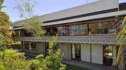
16 Lifford Road was architect Iwan Iwanoff’s own house and studio. The studio was located on the ground floor with the living accommodation on the upper level. The house is of concrete block construction with a continuous band of windows across the upper section of façade with angled block sills and a smaller band of similar windows to the lower level. The stark nature of the concrete blockwork has been enlivened by decorative concrete panels between windows and the entrance door at ground level. The house is built below road level with much of the house obscured from view through dense planting.
Iwan Nickolow Iwanoff (1919-1986) was born in Kusstendil, Bulgaria. After studying architecture in Munich at the Technische Hochschule from 1941, Iwanoff worked for Emil Freymuth with the pair winning second prize in the competition to rebuild the central area of Munich. Migrating to Australia as part of the International Refugee Organization resettlement scheme, Iwanoff and his wife arrived at Fremantle, on 2 March 1950. He worked with architecture firm Kranz and Sheldon and also Yuncken and Freeman in Melbourne. In 1963, he established his own practice, The Studio of Iwanoff. A gifted architect, Iwanoff had exceptional drawing abilities, an innovative `expressionistic’ approach to design and detailing and, above all, a conviction that architecture was an art. In 1963-86 his small office produced work of high quality, including numerous houses. He also designed shop fronts and interiors in central Perth, and one larger project, the civic administration centre and public library at Northam (1969-74). His creative use of concrete blocks is a noted feature of his work. Many of the Iwanoff residences designed in the 1960s and 1970s were in the new northern suburbs of Perth where there was often minimal surrounding development and often a clientele willing to explore new styles and techniques. This residence was designed by Iwanoff as a combination of architectural office and living accommodation for himself and his family. Aerial photographs indicate the form and extent of the place have not changed significantly since construction although internal modifications are likely to have been undertaken.
High Integrity High Authenticity
Good
| Name | Type | Year From | Year To |
|---|---|---|---|
| Iwan Iwanoff | Architect | 1966 | 1986 |
| Ref ID No | Ref Name | Ref Source | Ref Date |
|---|---|---|---|
| Duncan Richards, 'Iwanoff, Iwan (1919–1986)', Australian Dictionary of Biography, National Centre of Biography, Australian National University | 2007 | ||
| Goad, Philip; Willis, Julie 'The Encyclopaedia of Australian Architecture', Cambridge University Press | 2012 |
| Reserve | Lot/Location | Plan/Diagram | Vol/Folio |
|---|---|---|---|
| 1575 | Plan 6559 | 1753-589 |
| Owner | Category |
|---|---|
| Private owners | Other Private |
This information is provided voluntarily as a public service. The information provided is made available in good faith and is derived from sources believed to be reliable and accurate. However, the information is provided solely on the basis that readers will be responsible for making their own assessment of the matters discussed herein and are advised to verify all relevant representations, statements and information.
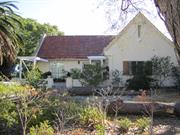
22 Lifford Rd Floreat
Cambridge
Metropolitan
Constructed from 1958
| Type | Status | Date | Documents |
|---|---|---|---|
| Heritage List | Adopted | 27 Nov 2018 |
| Type | Status | Date | Documents |
|---|---|---|---|
| (no listings) |
| Type | Status | Date | Grading/Management | |
|---|---|---|---|---|
| Category | ||||
| Municipal Inventory | Adopted | 27 Nov 2018 | Category 2 | |
Individual Building or Group
| Epoch | General | Specific |
|---|---|---|
| Original Use | RESIDENTIAL | Two storey residence |
| Present Use | RESIDENTIAL | Two storey residence |
| Style |
|---|
| Late 20th-Century International |
| Type | General | Specific |
|---|---|---|
| Roof | METAL | Zincalume |
| Wall | BRICK | Painted Brick |
| General | Specific |
|---|---|
| PEOPLE | Innovators |
This information is provided voluntarily as a public service. The information provided is made available in good faith and is derived from sources believed to be reliable and accurate. However, the information is provided solely on the basis that readers will be responsible for making their own assessment of the matters discussed herein and are advised to verify all relevant representations, statements and information.
Constructed from 1958
The place has aesthetic value as an intact example of the late 20th century international style and as a landmark in the streetscape. This residence and other examples of Iwanoff's work are a comprehensive and notable group of buildings which demonstrate a specific design style and period. The place has historic value for its association with prominent architect, Iwan Iwanoff who was influential in Western Australian practice for his non traditional approach to design and materials drawn from European trends. The place has historic value for its association with the late 1950s to the 1970s which was characterised as a period of affluence which was teamed with a willingness to experiment with new styles and materials. The place has social value as the house and others of Iwanoff's design are the source of study and interest amongst members of the community.
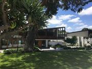
Part single storey part double storey house with distinctive skillion roofline extending across the full width of the house, terminating in an extensive balcony to the side elevation with tall concrete columns presenting in a stark angular form. A further balcony extends across part of the façade with timber balustrade. The façade is dominated by full height glazed panels and characteristic rubble stone panel wall.
Iwan Nickolow Iwanoff (1919-1986) was born in Kusstendil, Bulgaria. After studying architecture in Munich at the Technische Hochschule from 1941, Iwanoff worked for Emil Freymuth with the pair winning second prize in the competition to rebuild the central area of Munich. Migrating to Australia as part of the International Refugee Organization resettlement scheme, Iwanoff and his wife arrived at Fremantle, on 2 March 1950. He worked with architecture firm Kranz and Sheldon and also Yuncken and Freeman in Melbourne. In 1963, he established his own practice, The Studio of Iwanoff. A gifted architect, Iwanoff had exceptional drawing abilities, an innovative 'expressionistic' approach to design and detailing and, above all, a conviction that architecture was an art. In 1963-86 his small office produced work of high quality, including numerous houses. He also designed shop fronts and interiors in central Perth, and one larger project, the civic administration centre and public library at Northam (1969-74). His creative use of concrete blocks is a noted feature of his work. Many of the Iwanoff residences designed in the 1960s and 1970s were in the new northern suburbs of Perth where there was often minimal surrounding development and often a clientele willing to explore new styles and techniques. Plans and specifications for this residence were prepared by Iwanoff’s studio in 1958 for Siegfried SchmidtLademann who was appointed as German consul in Perth in 1957. The residence was designed for private living for Siegfried and Jutta Schmidt-Lademann and their family, and for formal receptions. The house was built in 1958 however in 1959 the consulate in Perth was closed and the house was sold. Since construction the place has had minor additions and alterations in 2001 and 2003 but the form and extent of the original construction is clear.
Integrity: High Authenticity: High
Excellent
| Name | Type | Year From | Year To |
|---|---|---|---|
| Iwan Iwanoff | Architect | 1958 | 1958 |
| Ref ID No | Ref Name | Ref Source | Ref Date |
|---|---|---|---|
| Goad, Philip; Willis, Julie [eds] The Encyclopaedia of Australian Architecture, Cambridge University Press, p. 357. | Book | 2012 | |
| The Schmidt-Lademann House | website | ||
| Duncan Richards, 'Iwanoff, Iwan (1919–1986)', Australian Dictionary of Biography, National Centre of Biography, Australian National University | Online Document | 2007 | |
| Aerial photographs, Landgate | Online Resources | 1953-2016 | |
| State Library of WA, Iwan Iwanoff Collection. MN1401, Acc 4400A | Plans |
| Reserve | Lot/Location | Plan/Diagram | Vol/Folio |
|---|---|---|---|
| 1593 | Plan 6559 | 1848-943 |
| Owner | Category |
|---|---|
| Private owners | Other Private |
This information is provided voluntarily as a public service. The information provided is made available in good faith and is derived from sources believed to be reliable and accurate. However, the information is provided solely on the basis that readers will be responsible for making their own assessment of the matters discussed herein and are advised to verify all relevant representations, statements and information.
49 Newry St Floreat
Lot 274
Cambridge
Metropolitan
| Type | Status | Date | Documents |
|---|---|---|---|
| (no listings) |
| Type | Status | Date | Documents |
|---|---|---|---|
| (no listings) |
| Type | Status | Date | Grading/Management | |
|---|---|---|---|---|
| Category | ||||
| (no listings) | ||||
Individual Building or Group
| Epoch | General | Specific |
|---|---|---|
| Present Use | RESIDENTIAL | Single storey residence |
| Original Use | RESIDENTIAL | Single storey residence |
This information is provided voluntarily as a public service. The information provided is made available in good faith and is derived from sources believed to be reliable and accurate. However, the information is provided solely on the basis that readers will be responsible for making their own assessment of the matters discussed herein and are advised to verify all relevant representations, statements and information.
47 Peebles Rd Floreat
Cambridge
Metropolitan
Constructed from 1960
| Type | Status | Date | Documents |
|---|---|---|---|
| Heritage List | Adopted | 27 Nov 2018 |
| Type | Status | Date | Documents |
|---|---|---|---|
| (no listings) |
| Type | Status | Date | Grading/Management | |
|---|---|---|---|---|
| Category | ||||
| Municipal Inventory | Adopted | 27 Nov 2018 | Category 2 | |
| Municipal Inventory | Adopted | 17 Dec 1996 | ||
| Catholic Church Inventory | Adopted | 01 Jul 1998 | ||
| Name | Type | Year From | Year To |
|---|---|---|---|
| Raymond Jones | Architect | - | - |
| Library Id | Title | Medium | Year Of Publication |
|---|---|---|---|
| 10150 | Raymond Jones Architecture: Part 1 - An overview. | Electronic | 2013 |
| 10151 | Raymond Jones Architecture: Part 2 - Raymond's Houses 1957 -1967 | Electronic | 2013 |
| 9746 | Raymond Jones: architectural projects | Book | 2011 |
Individual Building or Group
| Epoch | General | Specific |
|---|---|---|
| Present Use | RELIGIOUS | Church, Cathedral or Chapel |
| Original Use | RELIGIOUS | Church, Cathedral or Chapel |
| Style |
|---|
| Post-War Ecclesiastical |
| Type | General | Specific |
|---|---|---|
| Roof | METAL | Other Metal |
| Wall | CONCRETE | Pre-cast concrete panel |
| Other | GLASS | Glass |
| General | Specific |
|---|---|
| SOCIAL & CIVIC ACTIVITIES | Religion |
This information is provided voluntarily as a public service. The information provided is made available in good faith and is derived from sources believed to be reliable and accurate. However, the information is provided solely on the basis that readers will be responsible for making their own assessment of the matters discussed herein and are advised to verify all relevant representations, statements and information.
Constructed from 1962
Aesthetic significance for it's general design quality as an example of post-war ecclessiastical architecture. Historic and social significance representing the presence of the Roman Catholic Church in Floreat from the 1950's. Of particular significance to the members of the church.
The early 1960s church is of concrete panel construction with a distinctive glazed façade incorporating large panels of coloured glass. The church comes under the late 20th century ecclesiastical architectural design where traditional church design gave way to a more flexible design approach that was reflective of changing liturgical practices. St Cecilia’s is a five sided building with each face incorporating a shallow pitched gable roof creating a dynamic roofline resulting in a landmark building in the streetscape. The roof is clad in colorbond with skylights along the ridgeline of the western roof section. The principal façade is positioned at a slight angle facing the intersection of Grantham Street and Kenmore Crescent. The façade consists of three main bays of intersection glass and concrete panels flanked by angled glazed and concrete walls. The remaining elevations are a mix of plain concrete panelled walls and glazed and concrete panels walls. There is an element of transparency through the building courtesy of the abundance of windows. The church adjoins the Newman College site and is surrounded by both hard and soft landscaping.
By the late 1950's, it became apparent that another parish was needed to cope with the ever increasing numbers of Catholics moving into the areas beyond Wembley. Some years earlier the Perth City Council had allocated to the Archdiocese of Perth land bounded by Grantham & Brookdale Streets and Peebles Road and Kenmore Crescent. The initial four blocks were sold to the Brigidine Sisters and were used by them to build a secondary school. On the 20th March 1960, the parish of St. Cecilia's, Floreat was created. Initially, weekend masses were celebrated in the Floreat Park State School. The Church is named after St. Cecilia who was a Roman patrician, virgin, martyr, and patron saint of musicians who lived in the second and third centuries. The architectural design for the new church in Floreat was completed in May 1961 by local architect Raymond Jones. Raymond Alfredo Daniel Jones (1925- ), born in Geelong Victoria, trained at the University of Melbourne after serving with the Australian Navy during World War Two. He was particularly influenced by the works of Robin Boyd and as reflected in the spatial continuity between building and landscape, as well as his environmental design philosophy. Jones relocated to Western Australia in the 1950s and was an influential practitioner through the works of his own practice and as a mentor. He had ongoing interests and passions in ecological design, through the use of skillion roofing and courtyard spaces as well as passive ventilation and site orientation. Building of the church commenced in 1961 and completed within the year. The new church was blessed and dedicated by Archbishop Prendiville on 26th February 1961. The original presbytery was built alongside the church soon after. The Stations of the Cross, carved in wood in Genoa, Italy were donated to the parish and erected in the church in November 1964. The parking area for cars was completed in May 1966. Alterations to the sanctuary to facilitate the celebration of mass with the priest facing the congregation and the concrete and glass screen behind the altar were carried out over the course of 1968. In 1977, the confessional used for the Sacrament of Penance was modified to permit the option of "open" confession. Two years later, the Baptismal Font was relocated to the sanctuary. The altar rails were removed in 1982 to facilitate the congregation receiving communion standing up. During the course of 1986, specifications were drawn up for the purchase of a new pipe organ and construction of the organ began in February 1987. On 20 November 1987, St Cecilia's Church was solemnly dedicated by Archbishop Foley. The feast of St. Cecilia in 1988, marked the blessing of the organ by Bishop Healy and the inaugural recital by organist John Beaverstock, accompanied by a 17 piece chamber orchestra. The amalgamation of the two former separate parishes, Floreat and Wembley, took place in 1990. By 1998, the condition of the original presbytery had deteriorated to the extent that it was no longer habitable . Plans were developed for a new presbytery [with accommodation for two priests], parish offices, meeting rooms, and a hall with kitchen facilities and toilets. The new buildings, designated as the parish centre were constructed and occupied in 2000. In the second half of 2003, the sanctuary area of St. Cecilia's was significantly renovated with a marble floor being laid, a new Baptismal Font, the provision of additional lighting on the sanctuary, one confessional being converted to storage for musical instruments and related equipment and with the walls on either side of the altar being rendered. In November and December 2010, the sacristies were refurbished with new cupboards/storage facilities, some new tiling and blinds installed. The main lobby of the church was also re-carpeted. The roof of the Church, Parish Centre and presbytery were replaced in early 2012 having been damaged by a severe storm the previous year. To mark the 50th Anniversary of St Cecilia's Church in 2012, local sculptor Peter Graham, designed a sculptures in the form of a harp with a palm branch signifying St. Cecilia as patron of music and a martyr of the church. The sculpture is located in the courtyard between St. Cecilia's church and the Parish Centre.
Integrity: High Degree Authenticity: High Degree
Good
| Name | Type | Year From | Year To |
|---|---|---|---|
| Raymond Jones | Architect | 1962 | - |
| Ref ID No | Ref Name | Ref Source | Ref Date |
|---|---|---|---|
| Ahead of the Pack in Architectural Thinking, ABC News | Online Reference | 29 March 2011 | |
| Goad, Philip; Willis, Julie [eds] The Encyclopaedia of Australian Architecture, Cambridge University Press | Book | 2012 | |
| Floreat Wembley Catholic Parish | Website | 2017 | |
| Aerial photographs, Landgate. | Online Reference | 1953-2016 |
| Reserve | Lot/Location | Plan/Diagram | Vol/Folio |
|---|---|---|---|
| 1 | Diagram 96635 | 2204-352 |
| Owner | Category |
|---|---|
| Roman Catholic Archbishop of Perth | Church Property |
This information is provided voluntarily as a public service. The information provided is made available in good faith and is derived from sources believed to be reliable and accurate. However, the information is provided solely on the basis that readers will be responsible for making their own assessment of the matters discussed herein and are advised to verify all relevant representations, statements and information.
Perry Lakes Dr Floreat
Cambridge
Metropolitan
| Type | Status | Date | Documents |
|---|---|---|---|
| Heritage List | Adopted | 27 Nov 2018 |
| Type | Status | Date | Documents |
|---|---|---|---|
| (no listings) |
| Type | Status | Date | Grading/Management | |
|---|---|---|---|---|
| Category | ||||
| Municipal Inventory | Adopted | 27 Nov 2018 | Category 2 | |
| Municipal Inventory | Adopted | 17 Dec 1996 | ||
Landscape
| Epoch | General | Specific |
|---|---|---|
| Present Use | PARK\RESERVE | Park\Reserve |
| Original Use | PARK\RESERVE | Park\Reserve |
| General | Specific |
|---|---|
| PEOPLE | Aboriginal people |
This information is provided voluntarily as a public service. The information provided is made available in good faith and is derived from sources believed to be reliable and accurate. However, the information is provided solely on the basis that readers will be responsible for making their own assessment of the matters discussed herein and are advised to verify all relevant representations, statements and information.
The place has aesthetic value as a large well maintained parkland within a suburban setting that is accessible to the community. The place has historic value for its remnants of coastal bushland in the metropolitan area that has remained intact since the early 19th century. The place has historic value for its associations with prominent settlers Walter Padbury, Henry Trigg and Joseph Perry, who were significant figures in the early development of Western Australia. The place has historic value for its association with William Ernest Bold who was an influential leader in the City of Perth who shaped the development of this portion of the Town of Cambridge in the early 20th century. The place has social value for the members of the community who access the place for passive recreation and research. The reserve has social value for current and former scouts, guides and their leaders who have attended group activities at the site, especially the large jamboree's held in 1979 and 1994/5.
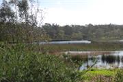
Perry Lakes adjoins Bold Park and is located on the east side of Perry Lakes Drive creating a large area of natural bushland and open lawn within an urban setting. The parkland provides a range of recreational facilities including ovals, walk trails and sporting facilities. The parkland is approximately 80 hectares in size and contains two lakes, East Lake and West Lake. The Fire Pit is located within the parkland, close to the scout hut and other sporting facilities. The pit is circular and of brick construction with a recessed central section and timber benches around the perimeter. A commemorative metal sculpture is located within the grounds that honours 75 years of Scouting which occurred in 1982. The sculpture also acknowledges the 1979 world wide jamboree which saw 12000 scouts camp at the site.
The area now defined as Perry Lakes has been identified by the Department of Aboriginal Affairs, Aboriginal Heritage Inquiry System as Heritage Place 3735 as a former camp and hunting place. As a wetland it is logical this place was used by the Whadjuk Noongar peoples for a range of functions prior to and following establishment of the Swan River colony in 1829. Following the foundation of Perth, the townsite was laid out and limestone was in great demand for construction in the new colony. The earliest lime kilns in Western Australia were established at the initial settlement sites of Fremantle and Albany in the 1830s, where settlers had access to local supplies of limestone. Henry Trigg, a carpenter and master builder from Gloucester, England arrived in the new colony of Western Australia in 1829. In I834, Trigg was granted 500 acres of land, which lay south of modern day Grantham Street, stretching from Floreat to the coastal sand hills. The western boundary of Trigg's land ran along the top of a limestone ridge. As a builder, Trigg recognised the value of this limestone outcropping and set up a quarrying and lime burning business. Trigg's business which became known as the 'Limekilns' prospered. In 1839, Trigg purchased neighbouring land to the south, including what is now Perry Lakes and One Tree Hill, (now known as Reabold Hill). In the same year, Trigg was appointed Superintendent of Public Works, and in this role was responsible for overseeing the erection of many early government buildings in Perth. In 1844, Walter Padbury, a pastoralist, acquired 426 acres of land adjacent to Trigg's property and later purchased Trigg's land including the Limekilns business for 2350, forming a 1,234 acre landholding which became known as the 'Limekilns Estate'. For the next 20 years Padbury built the Estate into a successful property, including the retention of the quarrying operations. At the height of operations, more than 50 men were employed at the quarry and lime kiln site. In 1869, brothers Henry and Somers Birch purchased the Limekilns Estate from Walter Padbury for £1,000. On 1 November 1875, during their ownership of the property, the explorer Ernest Giles arrived in Perth after his 2,500 mile journey from Port Augusta. His camels were rested at the Limekilns Estate and later in the 1890s, the Limekilns Estate served as a temporary quarantine station for camels imported to Western Australia to provide transport to the goldfields, with a lake now within Bold Park becoming known as Camel Lake. The Estate remained in the Birch's ownership until, 1880 when it was purchased by Joseph Perry for the sum of £1300. During his ownership, Perry kept the Quarry and limekilns in operation. Many of Perth's early public buildings, including the foundations of the Perth Town Hall (1870) were constructed using limestone from the quarry and kilns. In 1880, a portion of the Limekilns property was rented to Charles Ball who offered to supply lime which was described as the most superior in the colony, from lime kilns of 30 years standing. Private quarrying ceased operation in 1906 and the Limekilns Quarry (Quarry Amphitheatre) remained disused for many years. Changes to the rural nature of the area came about with the subdivision of land owned by the Catholic Church in 1911. This subdivision was called the Church Lands Estate, and the first house was constructed in 1912. In 1917, the Perth City Council purchased the 1290-acre Limekilns Estate from Perry for £18,000 and it linked to the Endowment Lands bestowed on the Perth City Council by the State Government in 1902. In January 1918, the Limekilns Estate was included within the boundaries of the City of Perth, and adjoined a further 2281 acres of Endowment Lands. The City envisioned opening out the quarries and using the limestone in the construction of city roads but also setting a portion of the land aside for a public park on the site of Perry's couch paddock and One Tree Hill (Reabold Hill). The exact date that the municipal Quarry ceased operation is not known, but it is likely that operations ceased in the 1920s with the beginning of the development of the area for housing. During the middle decades of the 20th century the quarry was unused and largely inaccessible. In 1919, One Tree Hill was renamed Reabold Hill after F. R Rea, the Mayor of Perth at the time the property was acquired by the City of Perth and W. E. Bold, the town clerk. By this time the lone Tuart tree that had previously sat atop the 286 ft. high hill, and given the place its name had disappeared. In 1925, an area of land of approximately 1000 acres was set aside as a place of recreation and was named Bold Park in honour of William Ernest Bold (1873-1953), the retiring town clerk. Other sources have designated that the naming occurred in 1936. Perry Lakes was included in the original boundaries of Bold Park when it was established by the City of Perth. Perry Lakes in its current form dates from 1962 when the area was landscaped in association with the construction of Perry Lakes Stadium and associated sporting tracks and facilities for the 1962 Empire Games. The Perry Lakes Stadium was demolished from 2010 to 2012 and is now being developed for residential occupancy. The Perry Lakes Reserve has been redeveloped as part of the Perry Lakes redevelopment project. New facilities for passive and formal recreation have been built on the site included a skate park and a nature play ground. Long term visitors to the Perry Lakes reserve have been groups of scouts and guides. The current Cambridge Scout and Guide Hall was built c2005 however prior to that fire pit has been located at the site for many years. Aerial photographs indicate the fire pit was present at the current location from the 1970s although further information is required to determine its date of construction. A commemorative sculpture is located within the grounds that honours 75 years of Scouting which occurred in 1982. The sculpture also acknowledges the 1979 world wide jamboree which saw 12000 scouts camp at the site. The Australian Scout Jamboree was again held on the site in 1994/95. The Town of Cambridge have instigated a management plan for the reserve with a particular focus on maintaining water levels which have been observed as declining in recent decades.
Good
| Ref ID No | Ref Name | Ref Source | Ref Date |
|---|---|---|---|
| Aerial photographs, Landgate. | Online Reference | 1953-2016 |
| Reserve | Lot/Location | Plan/Diagram | Vol/Folio |
|---|---|---|---|
| 720 | Plan 21069 | 2138-16 |
| Owner | Category |
|---|---|
| Town of Cambridge | Local Gov't |
This information is provided voluntarily as a public service. The information provided is made available in good faith and is derived from sources believed to be reliable and accurate. However, the information is provided solely on the basis that readers will be responsible for making their own assessment of the matters discussed herein and are advised to verify all relevant representations, statements and information.
1 Stadium Dr Floreat
Cambridge
Metropolitan
| Type | Status | Date | Documents |
|---|---|---|---|
| Heritage List | Adopted | 27 Nov 2018 |
| Type | Status | Date | Documents |
|---|---|---|---|
| RHP - To be assessed | Current | 24 Feb 2017 |
| Type | Status | Date | Grading/Management | |
|---|---|---|---|---|
| Category | ||||
| Municipal Inventory | Adopted | 27 Nov 2018 | Category 2 | |
09100 Perry Lakes Sporting Complex
Historic site
This information is provided voluntarily as a public service. The information provided is made available in good faith and is derived from sources believed to be reliable and accurate. However, the information is provided solely on the basis that readers will be responsible for making their own assessment of the matters discussed herein and are advised to verify all relevant representations, statements and information.
Constructed from 1962
09100 Perry Lakes Sporting Complex
The scoreboard has aesthetic value as an intact demonstration of the Post War International style executed in brick. The scoreboard has aesthetic value as a landmark in the streetscape as it is a unique element in a residential complex that is well known to many members of the community. The scoreboard has historic value for its association with the 1962 Empire and Commonwealth Games that were a significant event in the Perth community. The scoreboard has social value for the community for its association with past sporting and social events shared by large sections of the community.
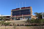
Perry Lakes Scoreboard is the last remaining element of the former sporting facilities erected for the commonwealth games in 1962. The scorecard sits in a prominent elevated position amidst contemporary townhouse developments which has resulted in a loss of context for the structure. The scoreboard is a three storey structure of pale brick construction to the ground level and side elevations. The upper levels of the façade are glazed with a glazed parapet topped with four flagpoles. The façade of the building has been altered with the double height glazing replacing the scoreboard, the removal of the balcony and the replacement of the small openings at ground level with full height window and door arrangements. Whilst the structure still makes a statement in the landscape, the integrity and authenticity of the structure has been degraded through the redevelopment of the site and adaptation of the scoreboard.
The Perry Lakes Scoreboard is the last element remaining from the former Perry Lakes Sporting Complex built in 1962 for the British Empire and Commonwealth Games. The facilities at the site were based around the athletics track and field ground and the associated stadium. When constructed the capacity of the stadium was 30,000 and the scoreboard was located at the southern end of the track. When constructed the scoreboard featured the latest technology in displays. An array of light globes were located across the front face of the scoreboard, letters and numbers were depicted in the lights and was a vast improvement on previous techniques which used either chalked boards or a series of numeric cards, flipped by the scorer. Perry Lakes Stadium was the venue for many events since 1962, notably annual school athletic sports carnivals, Country Week opening and closing ceremonies, rugby, soccer and concerts. For many decades basketball was played in covered courts to the west of the track and field stadium. The future of the site had been under discussion for many years as the facilities began to deteriorate and other venues took on the hosting of specific sports. Specifically the construction of the Western Australian Athletics Stadium in 2009 in nearby Underwood Avenue meant Perry Lakes was no longer used for athletics. Proposals to develop the site for residential occupancy were finalised c2009 and demolition of the stadium began in 2010,the grandstand was demolished in September 2012. Development of the site was the source of community discussion and it was resolved to retain the scoreboard at the site in recognition of the cultural heritage significance of the venue. The development also acknowledged the former use by using road names that reflected the sporting associations with the place. Current proposals indicate the scoreboard will be used only for community purposes for the occupants of the adjacent strata development. Together with modifications for community purposes, it has been proposed that the former scoreboard face will be clad with photovoltaic cells to power the common areas.
Integrity: Low Authenticity: Moderate
Good
| Ref ID No | Ref Name | Ref Source | Ref Date |
|---|---|---|---|
| Austadiums, Australian Stadiums and Sport website, http://www.austadiums.com | Online Reference | October 2017 | |
| Assessment Documentation for Place 9102 Quarry Amphitheatre prepared by the State Heritage Office 2017 for potential inclusion of the place in the State Register of Heritage Places | Online Reference | 2017 | |
| Cambridge Local Studies, Life of a Scoreboard, | Online Document | August 2014. | |
| Aerial photographs, Landgate. | Online Reference | 1953-2016 |
| Reserve | Lot/Location | Plan/Diagram | Vol/Folio |
|---|---|---|---|
| 230 | Deposited Plan 73849 | 2806/344 |
| Owner | Category |
|---|---|
| Town of Cambridge | Local Gov't |
This information is provided voluntarily as a public service. The information provided is made available in good faith and is derived from sources believed to be reliable and accurate. However, the information is provided solely on the basis that readers will be responsible for making their own assessment of the matters discussed herein and are advised to verify all relevant representations, statements and information.
The Boulevard Floreat
The Boulevard (between Cambridge St and Chipping Rd)
Cambridge
Metropolitan
| Type | Status | Date | Documents |
|---|---|---|---|
| (no listings) |
| Type | Status | Date | Documents |
|---|---|---|---|
| (no listings) |
| Type | Status | Date | Grading/Management | |
|---|---|---|---|---|
| Category | ||||
| Municipal Inventory | Adopted | 27 Nov 2018 | Category 4 | |
Tree
| Epoch | General | Specific |
|---|---|---|
| Original Use | PARK\RESERVE | Park\Reserve |
| Present Use | PARK\RESERVE | Park\Reserve |
This information is provided voluntarily as a public service. The information provided is made available in good faith and is derived from sources believed to be reliable and accurate. However, the information is provided solely on the basis that readers will be responsible for making their own assessment of the matters discussed herein and are advised to verify all relevant representations, statements and information.
Constructed from 1940 to 1950, Constructed from 1929
The trees have aesthetic value as mature trees in an urban setting that provides a leafy green quality to this main road and are landmarks in the streetscape. The trees have historic value for their association with the celebration of the centenary of the founding of the Swan River Colony. The planting of the trees in 1929 have historic value as an interesting contrast to the Foundation ceremony in 1829 which cut down a tree. The trees have social value for the community as the remaining trees have been a visual cue for the trip to City Beach since 1929.
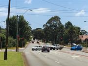
The trees along The Boulevard between the intersection with Cambridge Street and Chipping Road are located within the deep grassy verges and are a variety of species including pine, palm trees and gums. The trees create a clearly defined green edge to the road and provide some separation between the public and private realms.
The trees which remain on the verges of The Boulevard in Floreat and City Beach are those remaining from a ceremonial planting in recognition of the foundation of the colony in 1829. The City of Perth undertook to plant 365 trees on The Boulevard in part as a contrast to the ceremony in 1829 which cut down a tree in central Perth. The ceremony took place on 26th July 1929, and was performed by his Excellency the Governor (Sir William Campion) and Lady Campion, assisted by the Mayor of Perth (Mr. J. T. Franklin, M.L.C.) and Mrs. Franklin, members of the State Ministry and their wives, ex-Mayors, city councillors and civic officers and their wives. As described in the local press, 'The Boulevard, which curves north-westward from Cambridge-street, and is four miles long, will be planted with an avenue of trees. On each side of the roadway a line of Pinus insignis, with alternating palms and flowering gums in the foreground, will edge the drive, the present macadamized width of which will be doubled. Half a mile of the drive was planted yesterday, starting from the city end. Each lady who planted a tree received as a souvenir a miniature spade bearing Perth’s coat of arms. The planting done, the guests were given tea in a marquee, where speeches were made'. An item in the Lord Mayor's Report in 1942-43 recorded that 60 Jacaranda Trees were planted on The Boulevard in Floreat during that year at a cost of £64.4.0. It is probable that these trees are on the southern side of The Boulevard between Linden Gardens and the Floreat Forum shopping complex. In 1977/78, the City of Perth annual report recorded that pine trees were removed from The Boulevard because of ongoing problems with the reduced water table and poor rains. Those trees remaining from this initial period of planting are apparent from the intersection with Cambridge Street to Chipping Road in City Beach and are predominantly on the northern side of the road.
Integrity: High Authenticity: Moderate
Good
| Ref ID No | Ref Name | Ref Source | Ref Date |
|---|---|---|---|
| The Boulevard Treescape, in Follow the Old Plank Road | Online Reference | ||
| Cambridge Notes, T88, Town of Cambridge Local History Collection | Online Resources |
| Owner | Category |
|---|---|
| Town of Cambridge | Local Gov't |
This information is provided voluntarily as a public service. The information provided is made available in good faith and is derived from sources believed to be reliable and accurate. However, the information is provided solely on the basis that readers will be responsible for making their own assessment of the matters discussed herein and are advised to verify all relevant representations, statements and information.
The Boulevard Floreat
Bound by The Boulevard, Chandler Avenue West and Ulster Road
Cambridge
Metropolitan
| Type | Status | Date | Documents |
|---|---|---|---|
| (no listings) |
| Type | Status | Date | Documents |
|---|---|---|---|
| (no listings) |
| Type | Status | Date | Grading/Management | |
|---|---|---|---|---|
| Category | ||||
| Municipal Inventory | Adopted | 27 Nov 2018 | Category 4 | |
Urban Park
| Epoch | General | Specific |
|---|---|---|
| Present Use | PARK\RESERVE | Park\Reserve |
| Original Use | PARK\RESERVE | Park\Reserve |
| General | Specific |
|---|---|
| SOCIAL & CIVIC ACTIVITIES | Sport, recreation & entertainment |
This information is provided voluntarily as a public service. The information provided is made available in good faith and is derived from sources believed to be reliable and accurate. However, the information is provided solely on the basis that readers will be responsible for making their own assessment of the matters discussed herein and are advised to verify all relevant representations, statements and information.
Constructed from 1950
The place has aesthetic value as a well maintained grassed landscape featuring mature trees in an urban setting. The park has historic value for its association with the development of community facilities in Floreat in the 1950s when the suburb was more densely settled. The park has historic value for its association with City of Perth councillor, Herbert McLean who was active in the delivery of services and facilities for the Floreat community in the post war period. The park has social value as the venue for many formal and informal sports since the 1950s which have been attended by many members of the community, and as an adjunct to the Floreat Park Primary School.
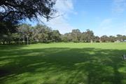
Forms part of the green open space adjacent to the residential development of Floreat. McLean park is a wide open grassed oval surrounded by peripheral planting and is laid out for organised sporting events as well as being used for local recreational purposes. The oval is surrounded by a grass bank creating an inviting seating area to watch the sporting events. The park provides additional sports fields for the events that take place at the adjacent Floreat Park.
Floreat underwent significant development in the period following World War II with the release of large parcels of land for residential subdivision. This growth built on the establishment of the suburb in the 1930s which followed garden suburb principles. Provision for community facilities was a concern of the Floreat Park Progress Association who were active in the 1940s. In the Lord Mayor’s Report of 1949/50 it was recorded that the council had pleasure in announcing that the 10 acre reserve to the north of the site designated for a community centre in Floreat Park was to be named McLean Park in recognition of the work of Councillor Herbert McDonald McLean (c1901-1991) in promoting the requests of the Floreat Park Progress Association. The report further described the grading, levelling, planting and watering undertaken to establish the standard size oval so it would be fit for the winter of 1951. The oval was also planned to be an adjunct for the Floreat Park Primary School. Since the creation of the oval it has been the venue for a range of organised sport and passive recreation. Facilities at the park have been constantly added to and improved since the establishment of the park.
Integrity: High Authenticity: High
Good
| Ref ID No | Ref Name | Ref Source | Ref Date |
|---|---|---|---|
| Town of Cambridge, Local History, Cambridge Notes, item T687 | Online Reference | ||
| The Daily News, p.9. | Newspaper | 1 May 1947 | |
| Aerial photographs, Landgate | Online Resources | 2012 |
| Reserve | Lot/Location | Plan/Diagram | Vol/Folio |
|---|---|---|---|
| 1774 | Plan 6135 | 1128-557 |
| Owner | Category |
|---|---|
| Town of Cambridge | Local Gov't |
This information is provided voluntarily as a public service. The information provided is made available in good faith and is derived from sources believed to be reliable and accurate. However, the information is provided solely on the basis that readers will be responsible for making their own assessment of the matters discussed herein and are advised to verify all relevant representations, statements and information.
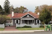
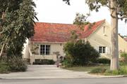
12 The Boulevard Floreat
Cambridge
Metropolitan
Constructed from 1934
| Type | Status | Date | Documents |
|---|---|---|---|
| Heritage List | Adopted | 27 Nov 2018 | |
| State Register | Registered | 28 Jun 2002 | HCWebsite.Listing+ListingDocument, HCWebsite.Listing+ListingDocument |
| Type | Status | Date | Documents |
|---|---|---|---|
| (no listings) |
| Type | Status | Date | Grading/Management | |
|---|---|---|---|---|
| Category | ||||
| Municipal Inventory | Adopted | 17 Dec 1996 | ||
| Municipal Inventory | Adopted | 27 Nov 2018 | Category 1 | |
Very Good condition
| Name | Type | Year From | Year To |
|---|---|---|---|
| Reginald Summerhayes | Architect | - | - |
Individual Building or Group
| Epoch | General | Specific |
|---|---|---|
| Original Use | RESIDENTIAL | Single storey residence |
| Present Use | RESIDENTIAL | Single storey residence |
| Style |
|---|
| Inter-War California Bungalow |
| Type | General | Specific |
|---|---|---|
| Wall | TIMBER | Weatherboard |
| Roof | TILE | Ceramic Tile |
| General | Specific |
|---|---|
| DEMOGRAPHIC SETTLEMENT & MOBILITY | Depression & boom |
| OCCUPATIONS | Domestic activities |
| DEMOGRAPHIC SETTLEMENT & MOBILITY | Land allocation & subdivision |
This information is provided voluntarily as a public service. The information provided is made available in good faith and is derived from sources believed to be reliable and accurate. However, the information is provided solely on the basis that readers will be responsible for making their own assessment of the matters discussed herein and are advised to verify all relevant representations, statements and information.
Constructed from 1934
Model Timber Home, a single-storey Jarrah weatherboard and tile residence in the Inter-War Californian Bungalow style set in original landscaped gardens and built as a model home in 1934, has cultural heritage significance for the following reasons: the place was one of two winning designs in the competition run by the Model Homes Committee as part of the Building Revival Campaign, an initiative to promote and stimulate employment in the home building industry during the economic depression of the 1930s; the place is a significant example of the work of architect Reg Summerhayes who was a prominent member of the architectural profession in Western Australia during the inter-war period; the place is a rare example of a home which has remained substantially unchanged with original fittings, furnishings and garden layout since its construction in 1934; the place was one of the first two homes built in the Floreat Park No 1 Estate, which was planned as a Garden Suburb by the City of Perth under the influence of Town Clerk WE Bold who promoted the principles of the Garden City Movement in Western Australia in the 1920s and 30s; and, the place has associations with J J Kenneally, Minister for Employment, who laid the foundation stone and who subsequently opened the house.
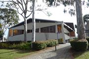
Model Timber Home located at 12 The Boulevard Floreat, comprises a single storey, painted Jarrah weatherboard and tile residence. The front elevation of the house is set back from the front boundary and located towards the eastern side of the lot with a pathway down the western side of the house. The front and side boundaries are defined by a low non-original picket fence. The front garden features many original plants including a tall poplar tree on the eastern side of the house, rose beds and borders of various flowering shrubs typical of gardens from the inter-war period. Fixed to the side of the house is the foundation stone laid by the Hon. J. J. Kenneally MLA, Minister for Employment and Industries, on 5 November 1933, on behalf of the Model Homes Committee. The house comprises the original section constructed in 1933 and a modest addition at the rear constructed in 1977. External walls are of painted Jarrah weatherboard on brick footings. The roof is moderately pitched and hipped with a feature gable over the front verandah. The roof is clad with terracotta tiles and the gable features vertically hung timber shingles which have been retained unpainted and stained, with a circular roof vent which is painted white. The eaves are wide and generally lined, apart from the eaves of the front gable which are battened. The eaves are finished with a timber facia board and ogee profile gutters. There are two chimneys, which are rendered and painted brick with a simple ridge detail to the tops with terracotta pots. The front verandah ring beam is supported on a series of circular tapered columns designed to give a classical effect, with a timber balustrade featuring vertical balusters and a central feature panel with a criss cross design. Windows are timber framed double hung casements with timber framed fly screens fixed externally. The sashes are divided into small panes with leadlight and have obscure glass borders. Windows to the front elevation have ornamental shutters with diamond shaped cut-outs and window boxes. The front door is timber with three vertical panels to the lower section and one glazed leadlight panel of obscure uncoloured glass. The door has matching side panels with sidelights. A steel mesh security screen is not original. The gardens are in good condition with original features, trees and plants.
In the nineteenth century the area to the north west of Perth known as the Large Lakes District was sparsely settled for agricultural purposes. The area currently known as Floreat comprised Locations Ak, to the west, and Al, in which Model Brick Home and Model Timber Home is currently located. Henry Trigg, builder and businessman acquired approximately 800 acres of this land and established a quarrying and lime burning enterprise on the property. In 1844 the property, known as the Limekilns Estate, was purchased by Walter Padbury and in 1869, the Limekilns Estate was sold to Henry and Somers Birch in for £1,000 and in 1880 to Joseph Perry for £1,950. The limekilns operated throughout the 1880s and 1890s and, until their closure in 1906, provided building materials for the developing residential areas of Subiaco and Leederville. The area between the Limekilns Estate and the coast remained crown land until 1855 when it was proclaimed the Endowment Lands. The Endowment Lands were originally part of the Perth Commonage, a large area bounded by the coast and extending from North Fremantle to north of Herdsman Lake. The purpose of the land was to provide income for municipal works through payment for use of the land for timber and stone. The Endowment Lands were vested in the Perth City Council in 1883, who were empowered to lease the land for a maximum of ten years. Settlement in the area between the City of Perth and the Limekilns Estate (present day West Leederville and Wembley) developed outwards from the city in a westerly direction in the period from the late nineteenth century to World War One. In 1917, the Limekilns Estate, which by this time comprised 1,290 acres (522 hectares), was purchased from Joseph Perry by the City of Perth for £18,000. This gave the City of Perth control of a continuous area of land from the city to the coast. The City of Perth Endowment Lands Act of 1920 enabled the City of Perth to develop and sell the previously allocated land. From the early 1900s, there had been proposals to construct a beach resort for city dwellers in the vicinity of present day City Beach. The emphasis, however, on development in this area differed from earlier development patterns, which had been dominated by speculation in land values with pressure exerted by private speculators. In the 1920s, the focus was put on the planning process with control exerted over road layout, proportion of open space, gardens and community service. The proponent for this was influential City of Perth Town Clerk, W. E. Bold. Bold was one of the State’s leading exponents of the Garden City Movement which had a direct influence on the planning of Floreat Park and City Beach. The United Kingdom's Housing and Planning Act of 1909 was recognition of the development of the discipline of Town Planning, which emerged as an outcome of the Garden Cities Movement in the early 1900s. The Garden Cities Movement developed in the UK in response to necessary improvements to residential amenities for workers in nineteenth century industrial cities. In 1910, the Royal Institute of British Architects held an inaugural Town Planning Conference in London. Copies of papers given at the conference were received in Perth together with a proposal that a lecture series be conducted in Australia by representatives of the Garden Cities and Town Planning Association. The issue was promoted by W E Bold and, in 1914, lectures were presented in Perth, Fremantle and Boulder by W R Davridge of the London County Council. Subsequently the first Australian Town Planning Conference andExhibition was held in Adelaide in October 1917. These ideas influenced Bold to promote the development of two satellite towns in the area west of Selby Street to be separated by a belt of undeveloped land. In 1925, the Perth City Council set aside the area known as Bold Park for this purpose. The area originally included Reabold Hill, Perry Lakes and the Wembley Golf Course. In 1925, the City of Perth commissioned Land Surveyors Hope and Klem to design two town sites, one located on the former Endowment Lands and the other on the eastern side of the former Limekilns Estate. The result was two plans with extensive use of curved roads. The eventual subdivisions, however, were modifications of the Hope and Klem designs. A direct outcome of the scheme was the construction of the Boulevard as an extension of Cambridge Street, from Selby Street, through the new area to the coast. The Boulevard was officially opened by Governor Sir William Campion on 23 November 1928. The sale of land in City Beach commenced in early 1929. By the late 1920s, the effects of the international economic depression were felt by Western Australia's building industry. In order to promote renewed confidence in home building, the industry established a Building Revival Committee which had widespread support from local government, industry and the professionals. The committee proposed the construction of two model homes, one of brick and one of timber, as a means of focusing attention on the advantages of home construction. It aimed to demonstrate to the public the extent to which labour was employed and the widespread dispersal of wages which would result from home building; thus revitalising the building industry and economy in general. As a result the Model Homes Committee of the Building Revival Campaign was formed with representatives from the Royal Institute of Architects, Master Builders and Contractors Association, Brick Manufacturers, Sawmillers Association, Economic Council, Hardware Association and the Perth sub-branch of Returned Services League (RSL). The committee hoped that material and labour would be donated, and it was decided that all profits would be used to provide relief from unemployment, particularly for youths. In the West Australian of 30 August 1933, the Secretary of the RIA, Mr. Reg Summerhayes, called for competitive designs for the houses with the commitment that the Institute would reimburse the winners for the preparation of drawings, specifications and architectural supervision. The houses were to be economical examples of ideal modern homes; the one of brick to cost no more than £850, and the one of timber to cost no more than £600. By the second meeting of the Model Homes Committee on 31 August 1933, the Perth City Council had agreed to donate two blocks of land in the satellite suburb of Floreat Park surveyed several years before. Although the Committee had twelve other blocks from which to choose, it selected the City of Perth offer. The winning designs were selected in the first week of November 1933. The winning entry for the timber home was by architect Mr Reg Summerhayes, R.I.A.. Explaining the salient features of his plan, Mr.Summerhayes said; "… that a simple compact plan had been arrived at, designed essentially for convenience and economy in the working of the home. The main living rooms - lounge and dining room - were located at the front of the house, with an ample front verandah to take advantage of the southwest summer winds....[the lounge had doors] leading off to a terrace...Hall and passage space had been kept to a minimum consistent with convenience and direct access to all rooms. Cupboards were provided for linen, coats etc. The kitchen was conveniently located and opened onto the back porch in which was the laundry. Plenty of cupboards were provided in the kitchen to accommodate food, china, pots and pans, etc..., all conveniently placed for efficient and comfortable working. The bedroom wing was self-contained, comprising two bedrooms, sleep-out and bathroom. Provision had been made behind the house for a large drying ground and a vegetable garden on one side of the block, and a formal garden with pool, paths and rose pergolas, etc., on the other side. The natural trees on the site would be retained as far as possible; and it is hoped that the layout of the garden at the back as suggested would encourage the adoption of this feature, set in natural surroundings. The exterior of the house had been kept quite simple, with a brick foundation, weatherboard walls and tile roof, with a definite Georgian feeling in the design, which was very adaptable to our conditions. The weatherboarding and other external timbers would be painted cream with the exception of the window shutters, which would be an apple-green. The gable would be green with split wood shingles, also painted." Messrs. H. W. Ennis and H. Pilgrim were nominated by the Master Builders and Contractors' Association to undertake the work of supervising construction, in cooperation with the architects. Materials and labour for the model homes, including shrubs for the gardens, were all donated. This was also extended to include the remission of sales tax on donations, and the Commissioner of Railways transported bricks over the government lines free of freight charge. The ceremony to lay the foundation stones (also donated) was held on Sunday 5 November 1933. The Lord Mayor of Perth, MR J T Franklin, officiated at the ceremony. Lieutenant Governor Sir James Mitchell and the Minister for Employment Mr. J. J. Kenneally laid the stones for the brick and timber houses respectively. Both model homes were opened at ceremonies held on 1 April 1934, again by the Lieutenant Governor and the Hon. J. J. Kenneally. The brick home was furnished, but the timber home was not. After the ceremony, the houses were opened to the public on various days, with afternoon tea provided by the Children'sHospital Women's Auxiliary. During the promotion of the model homes, land in the Floreat Park area was advertised for sale and development of the area soon commenced. In the first land auction held at Floreat Park on 14 April 1934, blocks sold for between £45 and £75. Model Timber Home and land was bought from the City of Perth by solicitor Douglas George Horley, on 23 August 1934. During World War Two, Douglas Horley was Senior Company Commander of the 2nd 16th Battalion and was killed in action in Syria on 13 June 1941. From 1941, Mrs Horley raised her three children in the home. In 1977, a modest addition was constructed to provide additional accommodation. This included two bedrooms, a new bathroom and a family room. The Horley family were associated with the home until the 2000s.
Authenticity: Very High Degree Integrity: Has been extended at the back but both the house and garden including paths and fencing and original planting are largely as originally constructed.
Good
| Name | Type | Year From | Year To |
|---|---|---|---|
| Reginald Summerhayes | Architect | 1934 | - |
| Ref ID No | Ref Name | Ref Source | Ref Date |
|---|---|---|---|
| PROWA Acc 3054: PCC File 1941/29 | PROWA;"Sale of Land at Floreat Park and Model Home Scheme". | 1941 |
| Reserve | Lot/Location | Plan/Diagram | Vol/Folio |
|---|---|---|---|
| 6 | 5659 | 1040-131 |
| Owner | Category |
|---|---|
| KD & LJ Waller | Other Private |
This information is provided voluntarily as a public service. The information provided is made available in good faith and is derived from sources believed to be reliable and accurate. However, the information is provided solely on the basis that readers will be responsible for making their own assessment of the matters discussed herein and are advised to verify all relevant representations, statements and information.
165 The Boulevard Floreat
Cambridge
Metropolitan
Constructed from 1965
| Type | Status | Date | Documents |
|---|---|---|---|
| (no listings) |
| Type | Status | Date | Documents |
|---|---|---|---|
| RHP - To be assessed | Current | 29 Sep 2006 |
| Type | Status | Date | Grading/Management | |
|---|---|---|---|---|
| Category | ||||
| Municipal Inventory | Adopted | 27 Nov 2018 | Category 4 | |
Damaged by fire in December 2015.
| Name | Type | Year From | Year To |
|---|---|---|---|
| Iwan Iwanoff | Architect | - | - |
Individual Building or Group
| Epoch | General | Specific |
|---|---|---|
| Original Use | RESIDENTIAL | Single storey residence |
| Style |
|---|
| Late 20th-Century Brutalist |
| Type | General | Specific |
|---|---|---|
| Wall | CONCRETE | Concrete Block |
| General | Specific |
|---|---|
| PEOPLE | Innovators |
| OCCUPATIONS | Commercial & service industries |
This information is provided voluntarily as a public service. The information provided is made available in good faith and is derived from sources believed to be reliable and accurate. However, the information is provided solely on the basis that readers will be responsible for making their own assessment of the matters discussed herein and are advised to verify all relevant representations, statements and information.
Constructed from 2017 to 2018
The place has aesthetic value as a reconstructed residence built from the original Iwanoff plans. The place has aesthetic value as a reconstruction of the late 20th century brutalist style and as a landmark in the streetscape. This reproduced residence and other examples of Iwanoff's work are a comprehensive and notable group of buildings which demonstrate a specific design style and period. The place has historic value for its association with prominent architect, Iwan Iwanoff who was influential in Western Australian practice for his non traditional approach to design and materials drawn from European trends. The place has historic value for its association with the early 1970s which was characterised as a period of affluence which was teamed with a willingness to experiment with new styles and materials. The place has social value as the house and others of Iwanoff's design are the source of study and interest amongst members of the community.
The original house designed by Iwanoff burnt down and is currently [2018] being rebuilt to the original plans.
Iwan Nickolow Iwanoff (1919-1986) was born in Kusstendil, Bulgaria. After studying architecture in Munich at the Technische Hochschule from 1941, Iwanoff worked for Emil Freymuth with the pair winning second prize in the competition to rebuild the central area of Munich. Migrating to Australia as part of the International Refugee Organization resettlement scheme, Iwanoff and his wife arrived at Fremantle, on 2 March 1950. He worked with architecture firm Kranz and Sheldon and also Yuncken and Freeman in Melbourne. In 1963, he established his own practice, The Studio of Iwanoff. A gifted architect, Iwanoff had exceptional drawing abilities, an innovative `expressionistic’ approach to design and detailing and, above all, a conviction that architecture was an art. In 1963-86 his small office produced work of high quality, including numerous houses. He also designed shop fronts and interiors in central Perth, and one larger project, the civic administration centre and public library at Northam (1969-74). His creative use of concrete blocks is a noted feature of his work. Many of the Iwanoff residences designed in the 1960s and 1970s were in the new northern suburbs of Perth where there was often minimal surrounding development and often a clientele willing to explore new styles and techniques. The Paganin family sold timber and marble, which encouraged extensive use of both materials throughout the house by Iwan Iwanoff, including a notable marble front verandah. The four-bedroom home has an open, practical layout, and according to the then president of the Western Australian chapter of the Australian Institute of Architects, Phil Griffiths, is "very expressionistic, very creative, and quite brilliant". Construction was completed in 1965. The house was recommended for listing in the State Heritage Register in 2006 (place number 17607). The property's original features were maintained and restored, and it was sold at auction by its second owner for $2.2 million in April 2013. In December 2015,the house was destroyed by fire. The owners are rebuilding the home to the original plans.
Integrity: High Authenticity: None
Excellent
| Name | Type | Year From | Year To |
|---|---|---|---|
| Iwan Iwanoff | Architect | 1965 | 1965 |
| Ref ID No | Ref Name | Ref Source | Ref Date |
|---|---|---|---|
| Aerial photographs, Landgate | Online Resources | 1953-2016 | |
| Duncan Richards, 'Iwanoff, Iwan (1919–1986)', Australian Dictionary of Biography, National Centre of Biography, Australian National University | Online Document | 2007 | |
| Goad, Philip; Willis, Julie 'The Encyclopaedia of Australian Architecture', Cambridge University Press, p. 357. | Book | 2012 |
| Reserve | Lot/Location | Plan/Diagram | Vol/Folio |
|---|---|---|---|
| 8 | Diagram 61756 | 1652-732 |
| Owner | Category |
|---|---|
| Private owners | Other Private |
This information is provided voluntarily as a public service. The information provided is made available in good faith and is derived from sources believed to be reliable and accurate. However, the information is provided solely on the basis that readers will be responsible for making their own assessment of the matters discussed herein and are advised to verify all relevant representations, statements and information.
6 The Boulevard Floreat
Cambridge
Metropolitan
Constructed from 1934
| Type | Status | Date | Documents |
|---|---|---|---|
| Heritage List | Adopted | 27 Nov 2018 | |
| State Register | Registered | 04 May 2001 | HCWebsite.Listing+ListingDocument, HCWebsite.Listing+ListingDocument |
| Type | Status | Date | Documents |
|---|---|---|---|
| (no listings) |
| Type | Status | Date | Grading/Management | |
|---|---|---|---|---|
| Category | ||||
| Municipal Inventory | Adopted | 17 Dec 1996 | ||
| Municipal Inventory | Adopted | 27 Nov 2018 | Category 1 | |
good condition
| Name | Type | Year From | Year To |
|---|---|---|---|
| Futura Constructions | Architect | - | - |
| Howard Bonner | Architect | - | - |
| Library Id | Title | Medium | Year Of Publication |
|---|
Individual Building or Group
| Epoch | General | Specific |
|---|---|---|
| Original Use | RESIDENTIAL | Single storey residence |
| Present Use | RESIDENTIAL | Single storey residence |
| Style |
|---|
| Inter-War Old English |
| Type | General | Specific |
|---|---|---|
| Roof | TILE | Ceramic Tile |
| Wall | BRICK | Rendered Brick |
| General | Specific |
|---|---|
| DEMOGRAPHIC SETTLEMENT & MOBILITY | Depression & boom |
| DEMOGRAPHIC SETTLEMENT & MOBILITY | Land allocation & subdivision |
| OCCUPATIONS | Domestic activities |
This information is provided voluntarily as a public service. The information provided is made available in good faith and is derived from sources believed to be reliable and accurate. However, the information is provided solely on the basis that readers will be responsible for making their own assessment of the matters discussed herein and are advised to verify all relevant representations, statements and information.
Constructed from 1934
The following statement is taken from the State Register Entry for Place 8894 Model Brick Home prepared in 2001 by the State Heritage Office. Model Brick Home, a single-storey brick and tile residence in a simplified version of the Inter-War Old English style set in landscaped gardens and built as a model home in 1934, has cultural heritage significance for the following reasons: the place was one of two winning designs in the competition run by the Model Homes Committee as part of the Building Revival Campaign, an initiative to promote and stimulate employment in the home building industry during the economic depression of the 1930s; designed by architect Howard Bonner, the place is a fine example of an architect designed home from the inter-war period, exhibiting their influence of a simplified form of the Inter-War Old English architectural style characterised by the dominant steeply pitched gabled roof and distinctive curved line of the front elevation; and the place was one of the first two homes built in the Floreat Park No. 1 Estate, which was planned as a Garden Suburb by the City of Perth under the influence of Town Clerk, W. E. Bold, who promoted the principles of the Garden City Movement in Western Australia in the 1920s and 30s.
residence which, together with the Model Timber Home located at 12 The Boulevard Floreat, was one of the first two homes constructed in Floreat Park No 1 Estate, a residential subdivision designed on the principles of a Garden Suburb. Model Brick Home is located on The Boulevard, one of the major roads in Floreat. Adjacent homes are of similar age, proportions and style, and apart from Model Timber Home, are brick or rendered brick and tile. All houses are of approximately equal setback with landscaped front gardens and an avenue of mature street trees. At the rear of the property, a gate from the back garden opens onto a laneway which accesses an area of public open space. This area, which has no street frontage, is landscaped with trees and shrubs and provides an additional recreational area for the houses which back onto it. Two grassed laneways access Selby Street. Model Brick Home is sited on a rectangular residential lot. The front elevation of the house is set back approximately 7.5m from the front boundary and located towards the eastern side of the lot, with a driveway down the western side of the house to the garage at the rear. There is a curved entrance driveway at the front of the house on the western side. The front garden area on the eastern side features a concrete slab retaining wall which separates the driveway from the garden. The house comprises the original section constructed in 1933 and additions constructed in 1995. The extension has been designed to complement the original in terms of roof pitch, materials and finish and is not visible from the street. External fabric of Model Brick Home features painted rendered masonry walls on limestone footings. The roof is steeply pitched (approximately 45º) and gabled with a prominent gabled wall to the front elevation with a rectangular timber vent at the apex. This wall extends in a prominent curve beyond the edge of the house to the eastern site boundary. There is a rendered banded detail to the top edge of the curved wall. An arched opening in the eastern side of the front elevation provides access to the side of the house through a timber garden gate. The roof is clad with terracotta tiles. Square profile gutters and downpipes are not original and the original chimney has been removed. There is an open terrace with low walls at the front of the house accessed by five front steps. The terrace and steps are clad with slate which is not original. Two timber pergolas which have been constructed over the front verandah are not original. The original foundation stone is extant on the front wall of the house. Original windows are timber framed six paned casements with timber mullions. The front door is timber with an elaborate diamond panel in the centre and original brass door handle. The French doors to the front terrace have aluminium frames and are not original. The same roof line and wall details have been continued or the 1995 extension. There have been no significant alterations to the place since the 1995 additions.
In the nineteenth century the area to the north west of Perth known as the Large Lakes District was sparsely settled for agricultural purposes. The area currently known as Floreat comprised Locations Ak, to the west, and Al, in which Model Brick Home and Model Timber Home is currently located. Henry Trigg, builder and businessman acquired approximately 800 acres of this land and established a quarrying and lime burning enterprise on the property. In 1844 the property, known as the Limekilns Estate, was purchased by Walter Padbury and in 1869, the Limekilns Estate was sold to Henry and Somers Birch in for £1,000 and in 1880 to Joseph Perry for £1,950. The limekilns operated throughout the 1880s and 1890s and, until their closure in 1906, provided building materials for the developing residential areas of Subiaco and Leederville. The area between the Limekilns Estate and the coast remained crown land until 1855 when it was proclaimed the Endowment Lands. The Endowment Lands were originally part of the Perth Commonage, a large area bounded by the coast and extending from North Fremantle to north of Herdsman Lake. The purpose of the land was to provide income for municipal works through payment for use of the land for timber and stone. The Endowment Lands were vested in the Perth City Council in 1883, who were empowered to lease the land for a maximum of ten years. Settlement in the area between the City of Perth and the Limekilns Estate (present day West Leederville and Wembley) developed outwards from the city in a westerly direction in the period from the late nineteenth century to World War One. In 1917, the Limekilns Estate, which by this time comprised 1,290 acres (522 hectares), was purchased from Joseph Perry by the City of Perth for £18,000. This gave the City of Perth control of a continuous area of land from the city to the coast. The City of Perth Endowment Lands Act of 1920 enabled the City of Perth to develop and sell the previously allocated land. From the early 1900s, there had been proposals to construct a beach resort for city dwellers in the vicinity of present day City Beach. The emphasis, however, on development in this area differed from earlier development patterns, which had been dominated by speculation in land values with pressure exerted by private speculators. In the 1920s, the focus was put on the planning process with control exerted over road layout, proportion of open space, gardens and community service. The proponent for this was influential City of Perth Town Clerk, W. E. Bold. Bold was one of the State’s leading exponents of the Garden City Movement which had a direct influence on the planning of Floreat Park and City Beach. The United Kingdom's Housing and Planning Act of 1909 was recognition of the development of the discipline of Town Planning, which emerged as an outcome of the Garden Cities Movement in the early 1900s. The Garden Cities Movement developed in the UK in response to necessary improvements to residential amenities for workers in nineteenth century industrial cities. In 1910, the Royal Institute of British Architects held an inaugural Town Planning Conference in London. Copies of papers given at the conference were received in Perth together with a proposal that a lecture series be conducted in Australia by representatives of the Garden Cities and Town Planning Association. The issue was promoted by W E Bold and, in 1914, lectures were presented in Perth, Fremantle and Boulder by W R Davridge of the London County Council. Subsequently the first Australian Town Planning Conference and Exhibition was held in Adelaide in October 1917. These ideas influenced Bold to promote the development of two satellite towns in the area west of Selby Street to be separated by a belt of undeveloped land. In 1925, the Perth City Council set aside the area known as Bold Park for this purpose. The area originally included Reabold Hill, Perry Lakes and the Wembley Golf Course. In 1925, the City of Perth commissioned Land Surveyors Hope and Klem to design two town sites, one located on the former Endowment Lands and the other on the eastern side of the former Limekilns Estate. The result was two plans with extensive use of curved roads. The eventual subdivisions, however, were modifications of the Hope and Klem designs. A direct outcome of the scheme was the construction of the Boulevard as an extension of Cambridge Street, from Selby Street, through the new area to the coast. The Boulevard was officially opened by Governor Sir William Campion on 23 November 1928. The sale of land in City Beach commenced in early 1929. By the late 1920s, the effects of the international economic depression were felt by Western Australia's building industry. In order to promote renewed confidence in home building, the industry established a Building Revival Committee which had widespread support from local government, industry and the professionals. The committee proposed the construction of two model homes, one of brick and one of timber, as a means of focusing attention on the advantages of home construction. It aimed to demonstrate to the public the extent to which labour was employed and the widespread dispersal of wages which would result from home building; thus revitalising the building industry and economy in general. As a result the Model Homes Committee of the Building Revival Campaign was formed with representatives from the RIA, Master Builders and Contractors Association, Brick Manufacturers, Sawmillers Association, Economic Council, Hardware Association and the Perth sub-branch of Returned Services League (RSL). The committee hoped that material and labour would be donated, and it was decided that all profits would be used to provide relief from unemployment, particularly for youths. In the West Australian of 30 August 1933, the Secretary of the RIA, Mr. Reg Summerhayes, called for competitive designs for the houses with the commitment that the Institute would reimburse the winners for the preparation of drawings, specifications and architectural supervision. The houses were to be economical examples of ideal modern homes; the one of brick to cost no more than £850, and the one of timber to cost no more than £600. By the second meeting of the Model Homes Committee on 31 August 1933, the Perth City Council had agreed to donate two blocks of land in the satellite suburb of Floreat Park surveyed several years before. Although the Committee had twelve other blocks from which to choose, it selected the City of Perth offer. The winning designs were selected in the first week of November 1933. The winning entry for the brick home was by architect H. Howard Bonner. Explaining the salient features of his plan, Mr. H. Howard Bonner said; "…. that he planned the accommodation so as to segregate the living, sleeping and cooking portions of the house into separate units. Access from the kitchen to the front door was given without passing through any room. Each bedroom was situated next to the bathroom. The service to the dining room from the kitchen through the servery should be quick and efficient and at the same time prevent cooking odours from the kitchen permeating the dining room. In case meals were served on the terrace a door leading from the kitchen to the terrace was provided. Entrance to the front door was gained from a small flagged court with a flower bed as a central feature and the sleeping-out verandah was accessible from both bedrooms. The living-room opened out onto a flagged terrace topped by a pergola. Built-in features included a seat and writing desk in the living-room and shelves for silver and crockery in the servery. In the kitchen there were cupboards over and under the draining board and a tradesman's hatch in a handy position. A hinged board over the trough in the laundry provided an ironing table. The layout of the land, he continued, provided for a separate service yard, screened off from the house by hedges, paved paths enclosed by hedges on the other side leading respectively to a central pool enclosed by a garden, and a small summer house and garden seat." Messrs. H. W. Ennis and H. Pilgrim were nominated by the Master Builders and Contractors' Association to undertake the work of supervising construction, in cooperation with the architects. Materials and labour for the model homes, including shrubs for the gardens, were all donated. This was also extended to include the remission of sales tax on donations, and the Commissioner of Railways transported bricks over the government lines free of freight charge. The ceremony to lay the foundation stones (also donated) was held on Sunday 5 November 1933. The Lord Mayor of Perth, MR J T Franklin, officiated at the ceremony. Lieutenant Governor Sir James Mitchell and the Minister for Employment Mr. J. J. Kenneally laid the stones for the brick and timber houses respectively. Both model homes were opened at ceremonies held on 1 April 1934, again by the Lieutenant Governor and the Hon. J. J. Kenneally. The brick home was furnished, but the timber home was not. After the ceremony, the houses were opened to the public on various days, with afternoon tea provided by the Children's Hospital Women's Auxiliary. During the promotion of the model homes, land in the Floreat Park area was advertised for sale and development of the area soon commenced. In the first land auction held at Floreat Park on 14 April 1934, blocks sold for between £45 and £75. Model Brick Home and land was bought from the City of Perth by Arthur Reginald Wright, salesman, on 12 September 1934. The ownership of the property changed hands a number of times since this original purchase. Alterations to Model Brick Home were carried out in 1951. These comprised construction of a room 14ft (4.26m) x 8 ft. (2.43m) on the north western side of the building, and a concrete driveway with a carport in front of an existing garage on the western side of the property. Further additions were carried out in 1995/96. These included the rear addition of a family room, two bedrooms, laundry, bathroom and terrace, as well as the replacement of the earlier garage and carport with a garden shed/workshop and garage. The 1951 extension was removed at this time. The current owner provided information in 2018 that the internal and external condition of the place has deteriorated in recent years largely through water ingress.
Integrity: High Authenticity: High
Good- restored
| Ref ID No | Ref Name | Ref Source | Ref Date |
|---|---|---|---|
| Acc3054 PCC File 1941/29 | PROWA;"Sale of Land at Floreat Park and Model Home Scheme". | 1941 | |
| Aerial photographs, Landgate. | Online Reference Documents | 1953-2016 |
| Owner | Category |
|---|---|
| JC Wood | Other Private |
This information is provided voluntarily as a public service. The information provided is made available in good faith and is derived from sources believed to be reliable and accurate. However, the information is provided solely on the basis that readers will be responsible for making their own assessment of the matters discussed herein and are advised to verify all relevant representations, statements and information.
82 The Boulevard Floreat
Cambridge
Metropolitan
Constructed from 1950
| Type | Status | Date | Documents |
|---|---|---|---|
| (no listings) |
| Type | Status | Date | Documents |
|---|---|---|---|
| (no listings) |
| Type | Status | Date | Grading/Management | |
|---|---|---|---|---|
| Category | ||||
| Anglican Church Inventory | YES | 31 Jul 1996 | ||
| Municipal Inventory | Adopted | 27 Nov 2018 | Category 4 | |
Individual Building or Group
| Epoch | General | Specific |
|---|---|---|
| Present Use | RELIGIOUS | Housing or Quarters |
| Original Use | RELIGIOUS | Housing or Quarters |
| Type | General | Specific |
|---|---|---|
| Roof | TILE | Cement Tile |
| Wall | BRICK | Common Brick |
| General | Specific |
|---|---|
| SOCIAL & CIVIC ACTIVITIES | Religion |
This information is provided voluntarily as a public service. The information provided is made available in good faith and is derived from sources believed to be reliable and accurate. However, the information is provided solely on the basis that readers will be responsible for making their own assessment of the matters discussed herein and are advised to verify all relevant representations, statements and information.
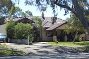
Constructed from 1950 to 1959
The place has some aesthetic value as a largely intact example of the post war International style executed in brick and tile. The place has historic value for its association with the establishment and development of the Anglican Church in the district in the period following World War Two. The place has social value for members of the community who have attended the premises in its role with the Anglican Community and for its continuity in the streetscape.
The place is a single storey dwelling that has undergone some alteration to the façade which has impacted on the authenticity and presentation of the place. The house is of brick, render and tile construction with an asymmetrical plan form to the façade. The central projecting bay has been extended to provide an increased covered entrance and two storey parking and accommodation element has been constructed to the western side of the façade. The house is set behind lawned gardens with additional plantings.
Dempster House was built in the late 1950s as the aerial photographs for late 1953 show no evidence of the building and the style of the residence is consistent with this period. It is not known if this place was built by the Wembley Parish or was acquired later for its use. The origin of the name 'Dempster House' is not known. The Anglican Parish of St Nicholas (Floreat Park) was initially part of the St Edmunds (Wembley) Parish and became a parish in its own right in 1972. At first, people from the Floreat area worshipped in the local tennis club. The congregation later gathered in the first church hall which was on the adjacent site (HN84-86 The Boulevard) in 1953. The church hall building project was organised by Rev Jack Watts, the Rector of the Wembley Parish. It is noted that Jack Watts and his wife lived in Pangbourne Street Wembley in the 1950s and 1960s. It is possible that this residence was acquired when the new parish was created in 1972 and used by the Floreat Parish priest. With the construction of the new parish hall in 1998/9, this property was sold to a private owner. Photographs of the building in 1996 show the place was originally face brick work. The current rendered finish appears to date from the late 1990s when it was transferred to the current owner.
Integrity: High Authenticity: Moderate
Good
| Ref ID No | Ref Name | Ref Source | Ref Date |
|---|---|---|---|
| St Nicholas' Anglican Church Floreat Park | Website | ||
| Aerial photographs, Landgate | Online Resources | 1953-2016 | |
| Cambridge Notes, Cambridge Local Studies Centre, Item T265. | Online Document |
| Reserve | Lot/Location | Plan/Diagram | Vol/Folio |
|---|---|---|---|
| 627 | Plan 6186 | 1127-846 |
| Owner | Category |
|---|---|
| Private owners | Other Private |
This information is provided voluntarily as a public service. The information provided is made available in good faith and is derived from sources believed to be reliable and accurate. However, the information is provided solely on the basis that readers will be responsible for making their own assessment of the matters discussed herein and are advised to verify all relevant representations, statements and information.
84 The Boulevard Floreat
Cambridge
Metropolitan
Constructed from 1952
| Type | Status | Date | Documents |
|---|---|---|---|
| (no listings) |
| Type | Status | Date | Documents |
|---|---|---|---|
| (no listings) |
| Type | Status | Date | Grading/Management | |
|---|---|---|---|---|
| Category | ||||
| Municipal Inventory | Adopted | 27 Nov 2018 | Category 5 | |
| Anglican Church Inventory | YES | 31 Jul 1996 | ||
Individual Building or Group
| Epoch | General | Specific |
|---|---|---|
| Original Use | RELIGIOUS | Church Hall |
| Present Use | RELIGIOUS | Church Hall |
| Type | General | Specific |
|---|---|---|
| Roof | TILE | Cement Tile |
| Wall | BRICK | Common Brick |
| General | Specific |
|---|---|
| SOCIAL & CIVIC ACTIVITIES | Religion |
This information is provided voluntarily as a public service. The information provided is made available in good faith and is derived from sources believed to be reliable and accurate. However, the information is provided solely on the basis that readers will be responsible for making their own assessment of the matters discussed herein and are advised to verify all relevant representations, statements and information.
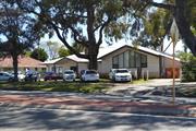
Constructed from 1999
11508 St Nicholas' Anglican Church
The site has historic value for its association with the first building constructed in the Wembley Parish by the Anglican Community. The site has social value for the community as the place continues to be used as a church hall which has been ongoing since 1953
The Hall was redeveloped in the late 1990s, replacing the earlier brick structure constructed in the 1950s. The current Hall is a single storey building fronting The Boulevard, and shares the site with the Church and the rectory is adjacent. St Nicholas' Hall is has incorporated the asymmetric planform of the original Hall, with the projecting wing containing a gable roof. In this instance, the window extends into the gable creating a large glazed feature to the frontage. The remainder of the building is more utilitarian in appearance, a centrally place double entrance door with canopy and a three section window are the only other features of the façade. The roof is a shallow pitched hip to the main part of the building, clad in colorbond.
The Anglican Parish of St Nicholas (Floreat Park) was initially part of the St Edmund's (Wembley) Parish until designated as its own parish in 1972. At first, people from the Floreat area worshipped in the tennis club. The parish later gathered in the church hall which was built on this site in 1953. The church hall foundation stone was laid in early 1953. The building project was organised by Rev Jack Watts, the Rector of the Wembley Parish which included Floreat Park. It was a functional design, built with restricted funds and designed by local parishioner architect Milton Boyce with assistance from Mr N.McGow. The builders were Harnett and Horner. The cost of the project was £9000, which was partly covered by a loan from the Diocesan Trustees for £5,500 and a gift from the Church Office of £1,500. The remaining £2,000 was fund raised by the local parishioners. On 6 December 1953, the completed St Nicholas Church Hall was consecrated by Archbishop Moline. The name was chosen by a small committee of ladies led by Mrs Carter and honours St Nicholas the patron saint of children. Fund raising to build a church in this developing parish began in the 1950s and the new church, St Nicholas' was completed just prior to the 1962 British Empire and Commonwealth Games. The church hall continued to provide a service to the community until it was no longer viable and the new building was opened in 1999. Dempster House located on the adjoining lot 82 The Boulevard and was used as the rectory for the parish. The three buildings have continued to provide a service to the community since the mid 20th century.
Good
| Ref ID No | Ref Name | Ref Source | Ref Date |
|---|---|---|---|
| Aerial photographs, Landgate | Online Resources | 1953-2016 | |
| St Nicholas' Anglican Church Floreat Park | Website | ||
| Cambridge Notes, Cambridge Local Studies Centre, Item T265. | Online Document |
| Reserve | Lot/Location | Plan/Diagram | Vol/Folio |
|---|---|---|---|
| 11 | Diagram 97372 | 2156-760 |
| Owner | Category |
|---|---|
| Anglican Diocese of Perth | Church Property |
This information is provided voluntarily as a public service. The information provided is made available in good faith and is derived from sources believed to be reliable and accurate. However, the information is provided solely on the basis that readers will be responsible for making their own assessment of the matters discussed herein and are advised to verify all relevant representations, statements and information.
Underwood Av Floreat
Basketball Stadium
Sir Thomas Meagher Pavilion
Cambridge
Metropolitan
Constructed from 1962 to 1990
| Type | Status | Date | Documents |
|---|---|---|---|
| (no listings) |
| Type | Status | Date | Documents |
|---|---|---|---|
| RHP - Does not warrant assessment | Current | 24 Feb 2017 |
| Type | Status | Date | Grading/Management | |
|---|---|---|---|---|
| Category | ||||
| Municipal Inventory | Adopted | 12 Nov 1996 | ||
| Name | Type | Year From | Year To |
|---|---|---|---|
| Green, WA McI | Architect | - | - |
| Library Id | Title | Medium | Year Of Publication |
|---|---|---|---|
| 8345 | Perry Lakes heritage assessment. | Heritage Study {Other} | 2006 |
| 9437 | Perry Lakes redevelopment plan | Heritage Study {Other} | 2008 |
| 9069 | A pictorial record of the VIIth British Empire and Commonwealth games. | Book | 1962 |
Individual Building or Group
| Epoch | General | Specific |
|---|---|---|
| Original Use | SOCIAL\RECREATIONAL | Grandstand |
| Other Use | SOCIAL\RECREATIONAL | Other Sports Building |
| Present Use | SOCIAL\RECREATIONAL | Grandstand |
| Present Use | SOCIAL\RECREATIONAL | Other Sports Building |
| Style |
|---|
| Late 20th-Century Perth Regional |
| Type | General | Specific |
|---|---|---|
| Wall | CONCRETE | Other Concrete |
| General | Specific |
|---|---|
| SOCIAL & CIVIC ACTIVITIES | Sport, recreation & entertainment |
| OUTSIDE INFLUENCES | Tourism |
This information is provided voluntarily as a public service. The information provided is made available in good faith and is derived from sources believed to be reliable and accurate. However, the information is provided solely on the basis that readers will be responsible for making their own assessment of the matters discussed herein and are advised to verify all relevant representations, statements and information.
185 Brookdale Rd Floreat Park
Cambridge
Metropolitan
| Type | Status | Date | Documents |
|---|---|---|---|
| (no listings) |
| Type | Status | Date | Documents |
|---|---|---|---|
| (no listings) |
| Type | Status | Date | Grading/Management | |
|---|---|---|---|---|
| Category | ||||
| Uniting Church Inventory | Completed | 01 Oct 1996 | ||
Individual Building or Group
| Epoch | General | Specific |
|---|---|---|
| Present Use | RELIGIOUS | Housing or Quarters |
| Original Use | RELIGIOUS | Housing or Quarters |
| Type | General | Specific |
|---|---|---|
| Wall | BRICK | Common Brick |
| Roof | TILE | Ceramic Tile |
| General | Specific |
|---|---|
| SOCIAL & CIVIC ACTIVITIES | Religion |
This information is provided voluntarily as a public service. The information provided is made available in good faith and is derived from sources believed to be reliable and accurate. However, the information is provided solely on the basis that readers will be responsible for making their own assessment of the matters discussed herein and are advised to verify all relevant representations, statements and information.
99 Jersey St Jolimont
Cambridge
Metropolitan
Constructed from 1927
| Type | Status | Date | Documents |
|---|---|---|---|
| Heritage List | Adopted | 27 Nov 2018 |
| Type | Status | Date | Documents |
|---|---|---|---|
| (no listings) |
| Type | Status | Date | Grading/Management | |
|---|---|---|---|---|
| Category | ||||
| Municipal Inventory | Adopted | 17 Dec 1996 | ||
| Municipal Inventory | Adopted | 27 Nov 2018 | Category 2 | |
Landscape
| Epoch | General | Specific |
|---|---|---|
| Present Use | PARK\RESERVE | Park\Reserve |
| Original Use | PARK\RESERVE | Park\Reserve |
| General | Specific |
|---|---|
| SOCIAL & CIVIC ACTIVITIES | Sport, recreation & entertainment |
This information is provided voluntarily as a public service. The information provided is made available in good faith and is derived from sources believed to be reliable and accurate. However, the information is provided solely on the basis that readers will be responsible for making their own assessment of the matters discussed herein and are advised to verify all relevant representations, statements and information.
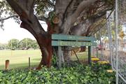
Constructed from 1985, Constructed from 1927, Constructed from 1902
The park has aesthetic value as a well maintained landscaped park in a largely built up environment which features a group of mature trees. The place has historic value for its association with the early 20th century in which this area was used for agricultural purposes as demonstrated by the decision to allocate this land for grazing. The place has historic value for its association with the establishment and growth of the Wembley district in the Inter War period when this land was set aside for recreational purposes. The place has social value for the many members of the community who have attended organised and informal events at the park, in addition to the many passive recreation users.
Large area of parkland in a corner position off Jersey Street and Salvado Road. The park has gently raised peripheral banks allowing for clear vistas across the sports oval. The park contains formal sports areas, training areas and clubroom facilities
The area now known as Henderson Park was originally part of the Perth Commonage vested in the City of Perth in 1879. The area bounded by Selby Street, Salvado Road, Jolimont and the alignment that later became Jersey Street, was designated the Leederville Endowment Lands in 1902 and rented out for grazing etc. with the intent that the profit from this would be used for municipal works when the Leederville Council amalgamated with the City of Perth in 1914 and the land reverted to the City of Perth. In 1927, the Wembley Progress Association requested the Perth City Council to provide additional public open space as the nearest recreational area was Lake Monger. The City Solicitor was called in to consider the uses to which the Leederville Endowment Lands could legally be put and the City Gardener recommended the use of the lands to the west of Jersey Street for recreational purposes. Henderson Park has been the headquarters of the Wembley Athletics Club, established in 1926, until its relocation to Wembley Sports Park in 2016. Henderson Park was named in recognition of Hugh Murray Henderson (c1882-1970) a Perth City Councillor, builder and official of the Wembley Athletics Club. Henderson established 'Henderson Homes' a local building company with many local employees, originally located on Cambridge Street near the corner of Corboy Street, which relocated to 9 Bishop Street Jolimont after World War II. Hugh Henderson had many sporting interests which he supported personally and professionally. He helped to establish and build the Wembley Golf Course, assisted in the construction of the City of Perth and Scarborough Surf Clubs and was Vice-President of the West Perth Football Club. The section of Jersey Street adjacent to Henderson Park, linking Jolimont and Wembley was constructed at the same time and gazetted in 1928. It is probable that the trees on the perimeter of the park were planted at this time. Henderson Park has continued to be used for a variety of sports since its establishment. Currently the lawn area is used for AFL, cricket, baseball, soccer and other team sports. Picnic and barbecue facilities and children's play equipment are also present at the park.
High Integrity High Authenticity
| Ref ID No | Ref Name | Ref Source | Ref Date |
|---|---|---|---|
| The Mirror, p. 10 | Newspaper | 4 March 1933, | |
| PROWA Acc 3054: PCC File 1928/181 | PROWA;" Parks and Reserves: Leederville Endowment Lands". | City of Perth | 1928 |
| Reserve | Lot/Location | Plan/Diagram | Vol/Folio |
|---|---|---|---|
| 9000 | 404549; 70583 | 2890-8 |
| Owner | Category |
|---|---|
| Town of Cambridge | Local Gov't |
This information is provided voluntarily as a public service. The information provided is made available in good faith and is derived from sources believed to be reliable and accurate. However, the information is provided solely on the basis that readers will be responsible for making their own assessment of the matters discussed herein and are advised to verify all relevant representations, statements and information.
199 Salvado Rd Jolimont
Cambridge
Metropolitan
| Type | Status | Date | Documents |
|---|---|---|---|
| Heritage List | Adopted | 27 Nov 2018 |
| Type | Status | Date | Documents |
|---|---|---|---|
| (no listings) |
| Type | Status | Date | Grading/Management | |
|---|---|---|---|---|
| Category | ||||
| Municipal Inventory | Adopted | 27 Nov 2018 | Category 3 | |
Other Built Type
| Epoch | General | Specific |
|---|---|---|
| Original Use | SOCIAL\RECREATIONAL | Other Sports Building |
| Present Use | SOCIAL\RECREATIONAL | Other Sports Building |
This information is provided voluntarily as a public service. The information provided is made available in good faith and is derived from sources believed to be reliable and accurate. However, the information is provided solely on the basis that readers will be responsible for making their own assessment of the matters discussed herein and are advised to verify all relevant representations, statements and information.
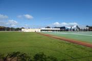
Constructed from 2013
The place has historic value for its association with the development of netball, formerly Women's basketball, in the 1950s and 1960s from an amateur sport to its current status as a well organised professional sports organisation. The place has historic value for its association with the development of Jolimont in the 1960s which was sparsely settled in the mid 20th century when land was set aside for the sports grounds. The place has historic value as the location of the second World Netball Championships in August 1967 which demonstrated the international recognition of Western Australia as a venue for sports at the highest level since the 1962 Empire Games. The place has historic value for its association with Maude Matthews who was President of the Women's Basketball Association when these courts were established in 1961. Her contribution is recognised in the naming of the courts in her honour. The place has social value for the many members of the community who have attended the place since 1961 as players, spectators or officials. The widespread popularity of the game has meant a significant portion of the Perth and wider Western Australian community have visited this place.
The Matthews Netball Centre has been home to netball since 1961 however the original building no longer exists. This site is now the location of the State Netball Centre, managed by the State Government and the Matthews Netball Centre owned and managed by the Town of Cambridge. The two new facilities were constructed in 2013.
The beginning of netball (known as Women’s Basketball until 1970) was initiated in WA through the YWCA, under the leadership of Miss Marjorie Black in 1924. Maude Matthews, President of the Western Australia Women’s Basket Ball Association (WAWBBA) from 1939-1942 and 1945-1962, worked closely with the Western Australian Government and Councillors from the Perth City Council to set aside this site bounded by Salvado Road and Selby Street for the establishment of a netball centre. The venue was subsequently named the ‘Matthews Basketball Centre’ in honour of her contribution. The first building was erected on the site in 1961 together with the provision of four hard stand courts and 46 grass courts and was officially opened in April of that year. The Centre became known as the ‘most outstanding’ Netball Centre in the Southern Hemisphere. In 1961 all teams in the metropolitan area played under the banner of Western Australian Basketball Association as there were no other metropolitan associations. With the inception of the Matthews’ Centre it was also possible to ‘house’ the staff of the State Body in one building to supervise and oversee all matches from the one location. In 1967 the Centre was host to the 1967 World Women's Basketball Tournament, and at the same time hosted the 1967 Australian National Titles. In 1971 ‘basketball’ was changed to ‘netball’ to bring Australia and New Zealand in line with the rest of the world. With the change in the sport’s name, the name of the centre was also changed to Matthews Netball Centre. As the numbers of netballers grew many other metropolitan associations came into operation as Matthews could not possibly take the number of teams wanting to participate. Associations including Fremantle, Midland, Southern Districts and Wanneroo came into force and are still in operation today. In 1990 the State Body left the Matthews’ Netball Centre to establish its headquarters away from any domestic competition, moving to various sites over time (until moving back again into its own building in 2015). At this time a strong group of volunteers met and formed the Perth Netball Association (Inc.) who continue to organise netball at the Matthews’ Netball Centre. After working with the Perth City Council for many years the centre came under the jurisdiction of the Town of Cambridge in 1994. In 2011, the Town of Cambridge endorsed the Wembley Sports Park Master Plan and work commenced on redevelopment of the site. The redevelopment consisted of the construction of a two new facilities, the State Netball Centre for the State Government and the Matthews Netball Centre for the Town of Cambridge. The building was finished and opened in 2013 and in addition to the undercover courts, provides offices a canteen for competition days, change rooms and storage space for clubs, and rooms for first aid and training courses. Currently [2018] Matthews Netball Centre has 48 courts.
Good
| Ref ID No | Ref Name | Ref Source | Ref Date |
|---|---|---|---|
| Perth Netball Association | Website | ||
| Netball WA | Website | ||
| Aerial photographs, Landgate | Online Resources | 1953-2016 |
| Reserve | Lot/Location | Plan/Diagram | Vol/Folio |
|---|---|---|---|
| 9000 | Plan 73717 | 2890-8 | |
| 9000 | Plan 404549 | 2890-8 |
| Owner | Category |
|---|---|
| Town of Cambridge | Local Gov't |
This information is provided voluntarily as a public service. The information provided is made available in good faith and is derived from sources believed to be reliable and accurate. However, the information is provided solely on the basis that readers will be responsible for making their own assessment of the matters discussed herein and are advised to verify all relevant representations, statements and information.
Oxford St Leederville
Cambridge
Metropolitan
Constructed from 1904, Constructed from 1900
| Type | Status | Date | Documents |
|---|---|---|---|
| (no listings) |
| Type | Status | Date | Documents |
|---|---|---|---|
| (no listings) |
| Type | Status | Date | Grading/Management | |
|---|---|---|---|---|
| Category | ||||
| Fire & Rescue Service Heritage Inventory | Adopted | 30 Aug 1997 | ||
Historic Site
| Epoch | General | Specific |
|---|---|---|
| Other Use | GOVERNMENTAL | Fire Station |
| Original Use | GOVERNMENTAL | Office or Administration Bldg |
| Present Use | GOVERNMENTAL | Office or Administration Bldg |
| General | Specific |
|---|---|
| OCCUPATIONS | Commercial & service industries |
This information is provided voluntarily as a public service. The information provided is made available in good faith and is derived from sources believed to be reliable and accurate. However, the information is provided solely on the basis that readers will be responsible for making their own assessment of the matters discussed herein and are advised to verify all relevant representations, statements and information.