Local Government
Cambridge
Region
Metropolitan
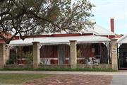
338-342 Cambridge St Wembley
Cambridge
Metropolitan
| Type | Status | Date | Documents |
|---|---|---|---|
| (no listings) |
| Type | Status | Date | Documents |
|---|---|---|---|
| (no listings) |
| Type | Status | Date | Grading/Management | |
|---|---|---|---|---|
| Category | ||||
| Municipal Inventory | Adopted | 27 Nov 2018 | Category 4 | |
Individual Building or Group
| Epoch | General | Specific |
|---|---|---|
| Original Use | COMMERCIAL | Shop\Retail Store {single} |
| Present Use | COMMERCIAL | Shop\Retail Store {single} |
| Style |
|---|
| Inter-War Stripped Classical |
| Type | General | Specific |
|---|---|---|
| Wall | BRICK | Rendered Brick |
| Roof | METAL | Corrugated Iron |
| General | Specific |
|---|---|
| OCCUPATIONS | Commercial & service industries |
This information is provided voluntarily as a public service. The information provided is made available in good faith and is derived from sources believed to be reliable and accurate. However, the information is provided solely on the basis that readers will be responsible for making their own assessment of the matters discussed herein and are advised to verify all relevant representations, statements and information.
Constructed from 1934
The place has aesthetic value as an example of an Inter War combined shop and retail premises with some original detail. The place has historic value for its association with the development of Wembley in the Inter War period and this section of Cambridge Street which was, and continues to be, a retail hub. The place has social value for its continuity of function as a commercial premises since the 1930s.
A row of four inter-war units under a single parapet and stepped awning. All four shop frontages have been altered to incorporate wider door openings with double doors and large display windows. The original arrangement of main shop windows and highlights has been retained albeit interpreted in a contemporary manner. The corner unit has an angled entrance with a further shop window on the return frontage to Alexander Street. This unit also has a lower verandah canopy although it is of the same style as the canopy to the adjoining units and supported by tie rods. The walls are predominantly rendered brickwork though the lower sections of the facades have been tiled to a couple of units.
This place is one of a number of buildings constructed in the mid 1930s to serve the growing community in the district. As was common practice the original building was a combined shop and residence. Its location on the corner of Cambridge and Alexander Streets was valuable exposure for the business. The shop portion of the building was divided into four premises. The first occupants of the shops in 1936 were; A. Shackletoy, Butcher; Christie, Tobacconist; Edward John Hill, Grocer and in the following year they were joined by Fishmonger Keith Spinks. The residence behind the shops was accessed from Alexander Street and this building was demolished c1982. A new grouping of retail premises were constructed on the site that was roughly consistent with the original building envelope. The shop premises have not changed significantly in form and extent since the mid 20th century.
Integrity: Moderate Authenticity: Moderate
Fair to good
| Ref ID No | Ref Name | Ref Source | Ref Date |
|---|---|---|---|
| Australian Electoral Rolls | 1901-1983 | ||
| Wise's Post Office Directories for the City of Perth, 1925-1949, State Library of WA | Online Reference | 1925-1949 | |
| Aerial photographs, Landgate | Online Resources | 1953-2016 | |
| Culpeffer-Cooke, Tony; Gunzburg, Adrian; Pleydell, Ian 'Tracks by the Swan The Electric Tram and Trolley Bus Era of Perth', Western Australia Perth Electric Tramway Society Inc | Book | 2010 |
| Reserve | Lot/Location | Plan/Diagram | Vol/Folio |
|---|---|---|---|
| 73 | Plan 3083 | 2076-578 |
| Owner | Category |
|---|---|
| Private owners | Other Private |
This information is provided voluntarily as a public service. The information provided is made available in good faith and is derived from sources believed to be reliable and accurate. However, the information is provided solely on the basis that readers will be responsible for making their own assessment of the matters discussed herein and are advised to verify all relevant representations, statements and information.
344 Cambridge St Wembley
Cambridge
Metropolitan
Constructed from 1932
| Type | Status | Date | Documents |
|---|---|---|---|
| Heritage List | Adopted | 27 Nov 2018 |
| Type | Status | Date | Documents |
|---|---|---|---|
| RHP - Does not warrant assessment | Current | 29 Oct 2004 |
| Type | Status | Date | Grading/Management | |
|---|---|---|---|---|
| Category | ||||
| Municipal Inventory | Adopted | 17 Dec 1996 | ||
| Municipal Inventory | Adopted | 27 Nov 2018 | Category 2 | |
| Classified by the National Trust | Classified | 02 May 1988 | ||
| Register of the National Estate | Nominated | 19 Feb 1991 | ||
| Art Deco Significant Bldg Survey | Completed | 30 Jun 1994 | ||
| Statewide Hotel Survey | Completed | 01 Nov 1997 | ||
| Register of the National Estate | Indicative Place | |||
Very Good
| Name | Type | Year From | Year To |
|---|---|---|---|
| E. leB. Henderson | Architect | - | - |
Individual Building or Group
| Epoch | General | Specific |
|---|---|---|
| Original Use | COMMERCIAL | Hotel, Tavern or Inn |
| Present Use | COMMERCIAL | Hotel, Tavern or Inn |
| Style |
|---|
| Federation Anglo-Dutch |
| Type | General | Specific |
|---|---|---|
| Wall | BRICK | Common Brick |
| Roof | TILE | Ceramic Tile |
| Wall | RENDER | Other Render |
| General | Specific |
|---|---|
| OCCUPATIONS | Hospitality industry & tourism |
This information is provided voluntarily as a public service. The information provided is made available in good faith and is derived from sources believed to be reliable and accurate. However, the information is provided solely on the basis that readers will be responsible for making their own assessment of the matters discussed herein and are advised to verify all relevant representations, statements and information.
Constructed from 1932, Constructed from 1989
The place has aesthetic value as a good intact example of the Inter War Mediterranean style executed in brick and tile demonstrating many intact external and internal details. The place has landmark value in Wembley and the Cambridge Streetscape as a prominent feature since 1932. The place has historic value for its association with the development of Wembley in the 1930s. The place has historic value for its association with prominent local architect, Edgar Le B Henderson, builders Snook and Sons and owners, the Cranley family. The place has social value to the community as a place of gathering for many social and formal events since the 1930s.
Substantial rendered brick and tile building constructed in an ‘L’ shape with dual frontages to Cambridge Street and Alexander Street. A drive through bottle shop has been constructed at the western end of the building, presenting with the same detailing as the main hotel. The façade is divided into a series of bays with feature gable sections to both elevations and a main corner entrance that has become obscured by trees. This entrance no longer has direct access from the street due to the construction of a boundary wall around the garden area. The ground level bays to Cambridge Street provide service access for deliveries with flush shutter doors whilst the upper bays were once hotel accommodation with direct access to the balcony that wraps around the façade. The bays to the Alexander Street elevation presents in a more traditional manner with both the ground and upper level elevation being recessed behind the verandah and balcony. The ground floor level is part of the public bar/restaurant area. Whereas the Cambridge Street elevation has been painted in muted tones with all traces of the face brickwork being obscured, the Alexander Street elevation has retained the brickwork providing a contrast with the rendered gables, fascias and upper level elevation. Other materials include timber balustrade to the balcony with square timber posts, open eaves, terracotta tiled roofs with corbelled brick chimneys, and timber framed windows. The place has undergone alteration but still clearly reflects the design intent of the place.
The building was designed for the owner Michael Francis Cranley (c1889-1979) by architect E le B Henderson and constructed by local builders Messrs Snooks & Sons in 1932 for the price of £7998. The hotel became a landmark on Cambridge Street as the end of the tramline and also the departing point for expeditions along the plank road to the beach. The hotel was owned by the Cranley family until the late 1980's when it was sold and extended to incorporate a shopping centre and a drive through bottle shop. These works required the demolition of the original beer garden. The hotel continues to be altered and added to in response to the changing needs and requirements of its patrons.
Integrity: High Authenticity: Moderate
Very Good
| Name | Type | Year From | Year To |
|---|---|---|---|
| E. leB. Henderson | Architect | 1932 | - |
| Ref ID No | Ref Name | Ref Source | Ref Date |
|---|---|---|---|
| "Building and Construction" 8.4 p13 | 1932 | ||
| "Building and Construction". 1.4 p 13 | 1932 | ||
| Wise's Post Office Directories for the City of Perth | Online Reference Documents | 1910-1949 | |
| Aerial Photographs | Landgate | 1953-2016 | |
| Culpeffer-Cooke, Tony; Pleydell, Ian 'Tracks by the Swan the Electric Tram & Trolley Bus era of Perth, Western Australia' | Perth Electric Tramway Society Inc. | 2010 |
| Reserve | Lot/Location | Plan/Diagram | Vol/Folio |
|---|---|---|---|
| 7 | Plan 18586 | 2070-600 |
| Owner | Category |
|---|---|
| Capebay Holdings Pty Ltd | Other Private |
This information is provided voluntarily as a public service. The information provided is made available in good faith and is derived from sources believed to be reliable and accurate. However, the information is provided solely on the basis that readers will be responsible for making their own assessment of the matters discussed herein and are advised to verify all relevant representations, statements and information.
The structure has architectural significance as a good example of one of the more limited number of hotels constructed during the 1930s. It survives in relatively intact condition. Thehotel is an interesting building illustrating the transition from Federation ot later styles. Later hotels of the period, including the Inglewood (1934), Captain Stirling (1935) and New Beaufort Hotels also have “Cape Dutch” gable decoration but feature Early Modern, Mediterranean and Art Deco styles. The hotel is of historical significance and indicative of a way of life now past. It was built at the terminus of the ram line which was then the extent of suburban development. The hotel was a popular holiday destination for many people from Perth as well as country areas. It was a departure point for expeditions along the plank road to the beach. The hotel has townscape value in that it strongly identifies with the built fabric of the surrounding suburb in terms of age, style and materials. It is a landmark in an area with very few landmarks.
The hotel is a two storey red brick and stucco building having elements of Federation and Art Deco in its design details. The hotel has a two storey verandah to the south and east elevations (the street facades) comprised of brick piers up to the first floor with Federation stuye timber posts and balustrading to the first floor. The top of the brick piers have detailed decorative capitols. A stuccoed “Cape Dutch” gable on the buildings truncated corner is also reflected by two similar smaller versions in the centre of the east and south elevations. The ground floor windows to the east elevation are of bevelled glass leadlighting. The ground floor area between the verandah piers along the south elevation has been unsympathetically filled with brick work to extend the public bar. This has destroyed the original ground floor bar entrance at the buildings corner truncation and also may have resulted in the loss of original bevelled glass windows to this elevation. The hotel has a terra cotta tile roof and high brick chimneys with Art Dec decorative tops. Internally, the public bar features the original timber panelled bar counter and pelmet with bevelled glass leadlighting. An original pressed metal ceiling is likely to exist above the more recently added suspended ceiling. The private residential entrance is situated in the centre of the east elevation. It has grand timber framed doors with bevelled glass leadlighting. The entrance foyer features a carved timber staircase, high timber moulded skirtings, a timber dado rail and a decorative ceiling. The entrance to the beer garden is via an open passageway from the south elevation. It retains the original decorative terrazzo floor and pressed metal ceiling. The beer garden situated at the rear of the building contains significant plantings including a very old almond tree.
Assessment 1988 Designed by Architect W.LeB. Henderson for Mr M. F. Cranley. A tender of £7998 from Messrs Snooks and Son was accepted in April 1932
This information is provided voluntarily as a public service. The information provided is made available in good faith and is derived from sources believed to be reliable and accurate. However, the information is provided solely on the basis that readers will be responsible for making their own assessment of the matters discussed herein and are advised to verify all relevant representations, statements and information.
347-349 Cambridge St Wembley
Cambridge
Metropolitan
| Type | Status | Date | Documents |
|---|---|---|---|
| Heritage List | Adopted | 27 Nov 2018 |
| Type | Status | Date | Documents |
|---|---|---|---|
| (no listings) |
| Type | Status | Date | Grading/Management | |
|---|---|---|---|---|
| Category | ||||
| Municipal Inventory | Adopted | 27 Nov 2018 | Category 3 | |
Individual Building or Group
| Epoch | General | Specific |
|---|---|---|
| Original Use | COMMERCIAL | Shop\Retail Store {single} |
| Present Use | COMMERCIAL | Shop\Retail Store {single} |
| Style |
|---|
| Post-War International |
| Type | General | Specific |
|---|---|---|
| Wall | BRICK | Painted Brick |
| Wall | BRICK | Common Brick |
| Roof | METAL | Corrugated Iron |
| General | Specific |
|---|---|
| OCCUPATIONS | Commercial & service industries |
This information is provided voluntarily as a public service. The information provided is made available in good faith and is derived from sources believed to be reliable and accurate. However, the information is provided solely on the basis that readers will be responsible for making their own assessment of the matters discussed herein and are advised to verify all relevant representations, statements and information.
The place has aesthetic value as an example of a Post War combined shop and retail premises with original detail. The place has historic value for its association with the development of Wembley in the Post War period and this section of Cambridge Street which was, and continues to be, a retail hub. The place has social value for its continuity of function as a commercial premises since the 1950s.
347 Cambridge Street (Lot 47) is a post war single storey retail unit with art deco inspired motif to the parapet. The building is of brick construction rendered to the façade and painted brickwork to the side. The parapet contains a central rendered fin and rendered capping, both painted in contrasting colour to add emphasis to the detail. The shop has retained the recessed entrance and angled shop windows with highlights across the entire façade. Although alterations have occurred, the original design intent of the buildings remains extant. Adjoining at 349 Cambridge Street (Lot 64) is a post war single storey brick commercial premises originally containing three retail units. The internal planning has been altered resulting in the amalgamation of two units to create Lawleys and the subdivision of the adjacent unit to create two small retail outlets. Despite the alterations to the frontages, they have retained an air of the traditional retail unit with large shop windows and glazed doors. The highlight windows have been retained though boarded over to the central shop units. The units are of brick construction which has not been painted. A verandah awning extends across the façade supported on tied rods and has pressed metal lining to the underside.
These premises were built in the 1950s and are representative of the population growth in the district following World War II. The architect and builder of the premises have not been determined in this research. This group of retail premises were built in stages although in rapid succession. The shop premises at 349 Cambridge Street was constructed prior to 1953 and was the premises of Wembley Real Estate Agency for many years. The premises at 347 Cambridge Street originally consisted of three premises which have subsequently been reduced to two tenancies. Aerial photographs indicate that the form and extent of the buildings have not changed significantly since that time.
Integrity: Moderate Authenticity: Moderate
Good
| Ref ID No | Ref Name | Ref Source | Ref Date |
|---|---|---|---|
| Wise's Post Office Directories for the City of Perth, 1925-1949, State Library of WA | Online Reference | 1925-1949 | |
| Culpeffer-Cooke, Tony; Gunzburg, Adrian; Pleydell, Ian 'Tracks by the Swan The Electric Tram and Trolley Bus Era of Perth', Western Australia Perth Electric Tramway Society Inc | Book | 2010 | |
| Aerial photographs, Landgate | Online Resources | 1953-2016 |
| Reserve | Lot/Location | Plan/Diagram | Vol/Folio |
|---|---|---|---|
| 47 | Plan 3083 | 2036-218 | |
| 46 | Plan 3083 | 2036-219 |
| Owner | Category |
|---|---|
| Private owners | Other Private |
This information is provided voluntarily as a public service. The information provided is made available in good faith and is derived from sources believed to be reliable and accurate. However, the information is provided solely on the basis that readers will be responsible for making their own assessment of the matters discussed herein and are advised to verify all relevant representations, statements and information.
352 Cambridge St Wembley
Cambridge
Metropolitan
| Type | Status | Date | Documents |
|---|---|---|---|
| (no listings) |
| Type | Status | Date | Documents |
|---|---|---|---|
| (no listings) |
| Type | Status | Date | Grading/Management | |
|---|---|---|---|---|
| Category | ||||
| Municipal Inventory | Adopted | 27 Nov 2018 | Category 4 | |
Individual Building or Group
| Epoch | General | Specific |
|---|---|---|
| Present Use | COMMERCIAL | Shop\Retail Store {single} |
| Original Use | COMMERCIAL | Shop\Retail Store {single} |
| Style |
|---|
| Post-War International |
| Type | General | Specific |
|---|---|---|
| Wall | BRICK | Painted Brick |
| Roof | METAL | Corrugated Iron |
| General | Specific |
|---|---|
| OCCUPATIONS | Commercial & service industries |
This information is provided voluntarily as a public service. The information provided is made available in good faith and is derived from sources believed to be reliable and accurate. However, the information is provided solely on the basis that readers will be responsible for making their own assessment of the matters discussed herein and are advised to verify all relevant representations, statements and information.
Constructed from 1950
The place has some aesthetic value as an example of a Post-World War II combined shop and retail premises. The place has historic value for its association with the development of Wembley in the Post War period and this section of Cambridge Street which was, and continues to be, a retail hub. The place has social value for its continuity of function as a commercial premises since the 1950s.
Single storey brick building with high parapet and bullnose verandah. The shop's windows have been replaced which impacts on its traditional aesthetic. The centrally placed single door is of traditional presentation with timber lower panel and glazed upper panel with a glazed side light. The verandah canopy is a replacement bullnose supported on tapered cylindrical columns on top of a masonry plinth. The entire façade has been painted.
These premises were constructed c1950 and are representative of the population growth in the district following World War II. The architect and builder of the buildings have not been determined in this research. The original buildings on the lot consisted of a linked shop and residence although it has not been established if the two were constructed at the same time although the stylistic elements suggest they were. The number of retail premises originally within this building appears to be only one. In the mid 1950s, advertising for electrical retailers, Blakes Pty Ltd, refers to their premises as 352 Cambridge Street indicating that no other tenancies occupied this place. Aerial photographs indicate that the addition of the brick awning detail for the restaurant dates from the early 1980s. A series of additions have been made to the rear of the restaurant tenancy on the eastern side of the lot. A two storey residence was constructed in the rear of the lot between 1965 and 1974 which is integrated into the original residence.
Integrity: Moderate Authenticity: Low
Good
| Ref ID No | Ref Name | Ref Source | Ref Date |
|---|---|---|---|
| Culpeffer-Cooke, Tony; Gunzburg, Adrian; Pleydell, Ian 'Tracks by the Swan The Electric Tram and Trolley Bus Era of Perth', Western Australia Perth Electric Tramway Society Inc | Book | 2010 | |
| The Mirror, p.3. | Newspaper | 25 February 1956 | |
| Aerial photographs, Landgate | Online Resources | 1953-2016 | |
| Australian Electoral Rolls | 1901-1983 | ||
| Wise's Post Office Directories for the City of Perth, 1925-1949, State Library of WA | Online Reference | 1925-1949 |
| Reserve | Lot/Location | Plan/Diagram | Vol/Folio |
|---|---|---|---|
| 78 | Plan 3083 | 1204-292 |
| Owner | Category |
|---|---|
| Private owners | Other Private |
This information is provided voluntarily as a public service. The information provided is made available in good faith and is derived from sources believed to be reliable and accurate. However, the information is provided solely on the basis that readers will be responsible for making their own assessment of the matters discussed herein and are advised to verify all relevant representations, statements and information.
361 Cambridge St Wembley
Cambridge
Metropolitan
| Type | Status | Date | Documents |
|---|---|---|---|
| (no listings) |
| Type | Status | Date | Documents |
|---|---|---|---|
| (no listings) |
| Type | Status | Date | Grading/Management | |
|---|---|---|---|---|
| Category | ||||
| Municipal Inventory | Adopted | 27 Nov 2018 | Category 4 | |
Individual Building or Group
| Epoch | General | Specific |
|---|---|---|
| Present Use | COMMERCIAL | Shop\Retail Store {single} |
| Original Use | COMMERCIAL | Shop\Retail Store {single} |
| Style |
|---|
| Post-War International |
| Type | General | Specific |
|---|---|---|
| Roof | METAL | Corrugated Iron |
| Wall | BRICK | Painted Brick |
| General | Specific |
|---|---|
| OCCUPATIONS | Commercial & service industries |
This information is provided voluntarily as a public service. The information provided is made available in good faith and is derived from sources believed to be reliable and accurate. However, the information is provided solely on the basis that readers will be responsible for making their own assessment of the matters discussed herein and are advised to verify all relevant representations, statements and information.

Constructed from 1938
The place has aesthetic value as an example of an Inter War combined shop and retail premises with some original detail. The place has historic value for its association with the development of Wembley in the Inter War period and this section of Cambridge Street which was, and continues to be, a retail hub. The place has social value for its continuity of function as a commercial premises since the 1930s.
Single storey inter-war commercial units of altered presentation. The arrangements of the shop frontages remains extant to the unit 361B but doors and windows have been replaced. The shop frontage to Units 361 and 361A have been completely remodelled with aluminium doors and windows which are flush to the street, removing the traditional recessed entrance and angled shop window. The building has a tall parapet wall which is obscured with signage and a verandah canopy supported on tie rods. The place is of brick construction which has subsequently been painted.
This place is one of a number of buildings constructed in the 1930s to serve the growing community in the district. As was common practice the building combined shops and residence. The shop portion of the building was divided into three premises. The first occupants of the premises were; 361 William J Bryant, Chemist; 361A Miss Elsie Elverd, hairdresser; and 361B D. McClaren, draper. These uses continued for many years and a chemist is still associated with the place. During the mid 1950s, one of the tenancies was occupied by Wembley Home Appliances which retailed records. Aerial photographs indicate that the form and extent of the premises have not changed significantly since the mid 1960s.
Good
| Ref ID No | Ref Name | Ref Source | Ref Date |
|---|---|---|---|
| Culpeffer-Cooke, Tony; Gunzburg, Adrian; Pleydell, Ian 'Tracks by the Swan The Electric Tram and Trolley Bus Era of Perth', Western Australia Perth Electric Tramway Society Inc | Book | 2010 | |
| Wise's Post Office Directories for the City of Perth, 1925-1949, State Library of WA | Online Reference | 1925-1949 | |
| Aerial photographs, Landgate | Online Resources | 1953-2016 | |
| The West Australian, p. 6. | 21 January 1954 | ||
| Australian Electoral Rolls | 1901-1983 |
| Reserve | Lot/Location | Plan/Diagram | Vol/Folio |
|---|---|---|---|
| 40 | Plan 3083 | 1178-760 |
| Owner | Category |
|---|---|
| Private owners | Other Private |
This information is provided voluntarily as a public service. The information provided is made available in good faith and is derived from sources believed to be reliable and accurate. However, the information is provided solely on the basis that readers will be responsible for making their own assessment of the matters discussed herein and are advised to verify all relevant representations, statements and information.
363 Cambridge St Wembley
Cambridge
Metropolitan
| Type | Status | Date | Documents |
|---|---|---|---|
| (no listings) |
| Type | Status | Date | Documents |
|---|---|---|---|
| (no listings) |
| Type | Status | Date | Grading/Management | |
|---|---|---|---|---|
| Category | ||||
| Municipal Inventory | Adopted | 27 Nov 2018 | Category 4 | |
Individual Building or Group
| Epoch | General | Specific |
|---|---|---|
| Present Use | COMMERCIAL | Shop\Retail Store {single} |
| Original Use | COMMERCIAL | Shop\Retail Store {single} |
| Style |
|---|
| Inter-War Stripped Classical |
| Type | General | Specific |
|---|---|---|
| Roof | METAL | Corrugated Iron |
| Wall | BRICK | Painted Brick |
| General | Specific |
|---|---|
| OCCUPATIONS | Commercial & service industries |
This information is provided voluntarily as a public service. The information provided is made available in good faith and is derived from sources believed to be reliable and accurate. However, the information is provided solely on the basis that readers will be responsible for making their own assessment of the matters discussed herein and are advised to verify all relevant representations, statements and information.
Constructed from 1970 to 1979, Constructed from 1934
The place has aesthetic value as an example of an Inter War combined shop and retail premises with some original detail. The place has historic value for its association with the development of Wembley in the Inter War period and this section of Cambridge Street which was, and continues to be, a retail hub. The place has social value for its continuity of function as a commercial premises since the 1930s.
Single storey commercial building of brick construction with shallow parapet. The building has been altered to the front but remains in keeping with the commercial character of the street. The shop windows have been made operable, opening up into the internal café spaces. The adjoining unit has similar operable windows across the majority of the façade. The units are of simple presentation. The original inter-war house that is set behind the retail units cannot be seen from Cambridge Street. The shop units were constructed in the mid-1970s.
This place consists of a residence and a group of retail premises built later in front of the residence facing Cambridge Street. The residence was built c1934 and was occupied and owned by printer Robert Harold Miller (c1909-1981). The retail premises were added to the front of the premises sometime between 1965 and 1974. Since that time the form and extent of the building has not changed significantly although it is apparent that the front elevation has been adapted and added to as occupants and requirements have changed.
Integrity: Moderate Authenticity: Moderate
Good
| Ref ID No | Ref Name | Ref Source | Ref Date |
|---|---|---|---|
| Wise's Post Office Directories for the City of Perth, 1925-1949, State Library of WA | Online Reference | 1925-1949 | |
| Culpeffer-Cooke, Tony; Gunzburg, Adrian; Pleydell, Ian 'Tracks by the Swan The Electric Tram and Trolley Bus Era of Perth', Western Australia Perth Electric Tramway Society Inc | Book | 2010 | |
| Aerial photographs, Landgate | Online Resources | 1953-2016 | |
| Australian Electoral Rolls | 1901-1983 |
| Reserve | Lot/Location | Plan/Diagram | Vol/Folio |
|---|---|---|---|
| 39 | Plan 3083 | 1118-609 |
| Owner | Category |
|---|---|
| Private owners | Other Private |
This information is provided voluntarily as a public service. The information provided is made available in good faith and is derived from sources believed to be reliable and accurate. However, the information is provided solely on the basis that readers will be responsible for making their own assessment of the matters discussed herein and are advised to verify all relevant representations, statements and information.
364 Cambridge St Wembley
Cambridge
Metropolitan
Constructed from 1953
| Type | Status | Date | Documents |
|---|---|---|---|
| Heritage List | Adopted | 27 Nov 2018 |
| Type | Status | Date | Documents |
|---|---|---|---|
| (no listings) |
| Type | Status | Date | Grading/Management | |
|---|---|---|---|---|
| Category | ||||
| Catholic Church Inventory | Adopted | 01 Jul 1998 | ||
| Municipal Inventory | Adopted | 17 Dec 1996 | ||
| Municipal Inventory | Adopted | 27 Nov 2018 | Category 2 | |
good
| Name | Type | Year From | Year To |
|---|---|---|---|
| Forbes & Fitzharding Architects | Architect | - | - |
Individual Building or Group
| Epoch | General | Specific |
|---|---|---|
| Original Use | RELIGIOUS | Church, Cathedral or Chapel |
| Present Use | RELIGIOUS | Church, Cathedral or Chapel |
| Style |
|---|
| Post-War Ecclesiastical |
| Type | General | Specific |
|---|---|---|
| Wall | BRICK | Common Brick |
| Roof | TILE | Ceramic Tile |
| General | Specific |
|---|---|
| SOCIAL & CIVIC ACTIVITIES | Religion |
This information is provided voluntarily as a public service. The information provided is made available in good faith and is derived from sources believed to be reliable and accurate. However, the information is provided solely on the basis that readers will be responsible for making their own assessment of the matters discussed herein and are advised to verify all relevant representations, statements and information.
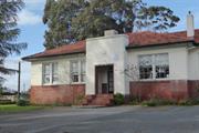
Constructed from 1954
The place has aesthetic value as an intact and good example of the Post-War ecclesiastical style executed in brick and concrete and as a landmark in the streetscape. The place has research value as the first example of prestressed concrete arches used in Western Australia and may provide information relating to the evolution of this technique. The place has historic value for its association with the development of the Wembley community in the period following World War Two. The place has social value for the members of the Wembley and wider community who have attended social and religious occasions at this church since 1954. The place has social value for the members of the Wembley Catholic community who were active in organising the construction of the church following the formation of the parish in 1947.
Substantial brick and tile church demonstrating the post-war ecclesiastical architectural style. The building is principally of cruciform plan form with the main body of the church extending on a north-south axis and gabled wings to the east and west elevations. Additional flat roof single storey accommodation of a more utilitarian design extends around the church on the east and north sides and to the rear of the west wing, although the principal design features of the main body of the church have been followed in these single storey sections the windows are smaller and the plinth is rendered. To the south of the west wing a double height area forms the main entrance into the church with large multi-paned window above the doorway. The bell tower is a tall narrow square tower with little adornment. The church is predominantly of brick construction with polychromatic patterned brickwork to the south elevation overlooking Cambridge Street and a stone plinth laid as uncoursed rubble with stones of varying sizes laid in irregular positions. A full height window extends up the eastern corner of the façade with rendered mullions and a patterned blockwork base. Windows to the east and west elevations are narrow strip windows of varying heights but each divided into a series of panes.
The Wembley Parish was formed in 1947, its founding Parish Priest was Father John Brosnan. Through the work of the parish, and support from the Diocese of Perth, funds were raised to build a school and subsequently a church to serve the Wembley Parish. The school was opened in November 1948 and was named Our Lady of Victories School. The community grew rapidly in the post war years and with constant fundraising the parish was able to employ architect Reginald Summerhayes to draw the plans for a new church in 1953. The design featured the first prestressed concrete arches used in Western Australia. Our Lady of Victories Church was opened and blessed by Archbishop Prendiville in August 1954. Since its construction the church has been the focal point for the parish of Wembley. The Wembley parishmerged with the neighbouring parish of Floreat in 1990. In c2002, the church undertook a redevelopment of the site and demolished the school and the church buildings on the corner of Marlow and Cambridge Streets. These portions of the site are now used for residential and commercial uses. The church has undergone very little change since construction.
Integrity: High Authenticity: High
Good
| Name | Type | Year From | Year To |
|---|---|---|---|
| Reginald Summerhayes | Architect | 1953 | - |
| Ref ID No | Ref Name | Ref Source | Ref Date |
|---|---|---|---|
| Our Lady of Victories Roman Catholic Church, Wembley Conservation Plan compiled by Naomi Lawrence Architect, for David Barnao & Co on behalf of the Floreat/Wembley Parish | Report | 2002 | |
| M Putt;"Wembley, It's People and It's Past". | City of Perth | 1990 | |
| Aerial Photographs | Landgate | 1953-2016 | |
| closed file: PR 00533 V2 | Heritage Agreement executed by the Town of Cambridge | Town of Cambridge | 2003 |
| Reserve | Lot/Location | Plan/Diagram | Vol/Folio |
|---|---|---|---|
| 17 | Plan 41397 | 2556-399 |
| Owner | Category |
|---|---|
| Roman Catholic Archbishop | Church Property |
This information is provided voluntarily as a public service. The information provided is made available in good faith and is derived from sources believed to be reliable and accurate. However, the information is provided solely on the basis that readers will be responsible for making their own assessment of the matters discussed herein and are advised to verify all relevant representations, statements and information.
377A Cambridge St Wembley
Cambridge
Metropolitan
| Type | Status | Date | Documents |
|---|---|---|---|
| (no listings) |
| Type | Status | Date | Documents |
|---|---|---|---|
| (no listings) |
| Type | Status | Date | Grading/Management | |
|---|---|---|---|---|
| Category | ||||
| Municipal Inventory | Adopted | 27 Nov 2018 | Category 4 | |
Individual Building or Group
| Epoch | General | Specific |
|---|---|---|
| Original Use | RESIDENTIAL | Single storey residence |
| Present Use | RESIDENTIAL | Single storey residence |
| Style |
|---|
| Inter-War California Bungalow |
| Type | General | Specific |
|---|---|---|
| Roof | TILE | Terracotta Tile |
| Wall | BRICK | Common Brick |
| General | Specific |
|---|---|
| DEMOGRAPHIC SETTLEMENT & MOBILITY | Settlements |
This information is provided voluntarily as a public service. The information provided is made available in good faith and is derived from sources believed to be reliable and accurate. However, the information is provided solely on the basis that readers will be responsible for making their own assessment of the matters discussed herein and are advised to verify all relevant representations, statements and information.

Constructed from 1935
The place has aesthetic value as an example of an Inter War residence with original detail. The place has historic value for its association with the development of Wembley in the Inter War period. The place has social value for its demonstration of the form and scale of housing in the Inter War period.
This entry relates only to the residence on Strata Lot 3. Single storey brick and tile interwar house of traditional asymmetric plan form. The house cannot be clearly seen from the street due to a high wall, gates and planting and therefore its contribution to the street is negligible. A carport has been constructed in the front setback opening directly onto the street which further compromises the contribution to the place to the character of the street. From the limited visual access obtained from the street, it appears the house is little altered with face brickwork, flat canopy to the windows across the recessed section of the elevation, separate hip to the verandah canopy supported on brick columns with rendered balustrade. The main roof is a tiled hipped form with tall brick chimneys.
This residence was constructed for the owner and occupier Simon Wright and his wife Mabel Victoria Wright. The couple lived at the until 1953 when they advertised the property for sale as the 'owners were going east'. Simon Wright recorded his occupation as a contractor so he may have been involved in the construction of the residence. The place continued to be used as a residence and in the late 1990s the lot was subdivided enabling the construction of two new residences at the rear of the lot. At this time the former grey, possibly concrete, tiles on the roof, were replaced with red tiles and a new carport was constructed on the front of the lot.
Good
| Ref ID No | Ref Name | Ref Source | Ref Date |
|---|---|---|---|
| Wise's Post Office Directories for the City of Perth, 1925-1949, State Library of WA | Online Reference | 1925-1949 | |
| Aerial photographs, Landgate | Online Resources | 1953-2016 | |
| Culpeffer-Cooke, Tony; Gunzburg, Adrian; Pleydell, Ian 'Tracks by the Swan The Electric Tram and Trolley Bus Era of Perth', Western Australia Perth Electric Tramway Society Inc | Book | 2010 | |
| Australian Electoral Rolls | 1901-1983 | ||
| The West Australian, p. 28. | 30 January 1953 |
| Reserve | Lot/Location | Plan/Diagram | Vol/Folio |
|---|---|---|---|
| Strata Lot 3 | Strata Plan 33809 | 2207-541 | |
| Parent Lot 6 | Plan 79965 | 2207-541 |
| Owner | Category |
|---|---|
| Private owners | Other Private |
This information is provided voluntarily as a public service. The information provided is made available in good faith and is derived from sources believed to be reliable and accurate. However, the information is provided solely on the basis that readers will be responsible for making their own assessment of the matters discussed herein and are advised to verify all relevant representations, statements and information.
379 Cambridge St Wembley
Cnr Marlow St
Cambridge
Metropolitan
Constructed from 1955
| Type | Status | Date | Documents |
|---|---|---|---|
| Heritage List | Adopted | 27 Nov 2018 |
| Type | Status | Date | Documents |
|---|---|---|---|
| RHP - To be assessed | Current | 28 Sep 2012 |
| Type | Status | Date | Grading/Management | |
|---|---|---|---|---|
| Category | ||||
| Municipal Inventory | Adopted | 27 Nov 2018 | Category 2 | |
Individual Building or Group
| Epoch | General | Specific |
|---|---|---|
| Original Use | GOVERNMENTAL | Police Station or Quarters |
| Present Use | GOVERNMENTAL | Police Station or Quarters |
| General | Specific |
|---|---|
| SOCIAL & CIVIC ACTIVITIES | Law & order |
This information is provided voluntarily as a public service. The information provided is made available in good faith and is derived from sources believed to be reliable and accurate. However, the information is provided solely on the basis that readers will be responsible for making their own assessment of the matters discussed herein and are advised to verify all relevant representations, statements and information.
Constructed from 1980, Constructed from 1951
The place has aesthetic value as a good intact example of a post war residential scaled police station executed in brick and tile which retains many original details. The place has historic value for its association with the development of Wembley in the post World War Two period and the government response to these demands for services. The place has social value for the members of the community as the police station has been an ongoing presence since the mid 1950s.
Post war single storey domestic scale building utilised as a police station. The principal façade faces Marlow Street incorporating a traditional asymmetric planform. The ‘cut-out’ corner to the north-west corner of the Cambridge Street elevation forms a covered porch/verandah area with the entrance door facing towards Marlow Street. Originally of ‘L’ shape plan form, the building has been extended towards the south with a substantial rectangular addition of similar design. The building is of brick and tiled construction with timbered gable to Marlow Street and rendered wall beneath the main window to Cambridge Street. The porch/verandah area has a timber wall to the west elevation, solid to the lower four panels with 12 open panels above.
The site for the future Wembley Police Station was secured by the government in the late 1940s but it was not until 1955 that the station was built. Tenders were called for the construction of the building from 1951 until 1954, the delay in going ahead with the project has not been determined. An addition to the station was made c1980 almost doubling the size of the original building. Parking and landscaping have continually been upgraded since the original construction and the premises continued to be used for their original function in the community.
Integrity: High Authenticity: High
Good
| Ref ID No | Ref Name | Ref Source | Ref Date |
|---|---|---|---|
| Government Gazettes | Journal | 1951 | |
| Culpeffer-Cooke, Tony; Gunzburg, Adrian; Pleydell, Ian 'Tracks by the Swan The Electric Tram and Trolley Bus Era of Perth', Western Australia Perth Electric Tramway Society Inc | Book | 2010 | |
| Aerial photographs, Landgate | Online Resources | 1953-2016 | |
| The West Australian, p. 3. | Newspaper | 30 November 1954 |
| Reserve | Lot/Location | Plan/Diagram | Vol/Folio |
|---|---|---|---|
| 36181 | 9997 | Plan 3083 | LR3048-153 |
| Owner | Category |
|---|---|
| State Government | State Gov't |
This information is provided voluntarily as a public service. The information provided is made available in good faith and is derived from sources believed to be reliable and accurate. However, the information is provided solely on the basis that readers will be responsible for making their own assessment of the matters discussed herein and are advised to verify all relevant representations, statements and information.
24A Connolly St Wembley
Cambridge
Metropolitan
Constructed from 1912
| Type | Status | Date | Documents |
|---|---|---|---|
| Heritage List | Adopted | 27 Nov 2018 |
| Type | Status | Date | Documents |
|---|---|---|---|
| RHP - Does not warrant assessment | Current | 29 Aug 2014 |
| Type | Status | Date | Grading/Management | |
|---|---|---|---|---|
| Category | ||||
| Municipal Inventory | Adopted | 27 Nov 2018 | Category 3 | |
The place is a good and intact example of a residence in the Federation Queen Anne style; and the place is associated with the early settlement of the Cambridge area in c1860s by the Roman Catholic Church who acquired several parcels of land in the area.
Edwardian residential dwelling. The house is original apart from the kitchen, bathroom and back varandah. Described in nomination as the last house of its type and vintage in Connolly Street and possibly Wembley. Features include a leadlight glass door at the enterance, decorative plaster ceiling roses, 12ft ceilings, timber flooring, original fireplace in the sitting room and plaster picture rails.
A Landgate historical title search shows that the land on which Horton House now sits was part of the greater area of land originally owned by the Roman Catholic Bishop Joseph Serra, and was then transferred to Roman Catholic Bishop Matthew Gibney in 1860. The land remained in the ownership of the Roman Catholic Bishop of Perth until 1911, after which time it was transferred to Annie & Lydia Kidd. According to the current owners, Horton House was constructed the following year in 1912. The house has continued to be used as a private residence to the present day.
Individual Building or Group
| Epoch | General | Specific |
|---|---|---|
| Original Use | RESIDENTIAL | Single storey residence |
| Style |
|---|
| Federation Free Style |
| Type | General | Specific |
|---|---|---|
| Wall | BRICK | Pointed Brick |
| Wall | PLASTER | Plaster, decorative |
| Roof | METAL | Corrugated Iron |
| Other | CONCRETE | Concrete Slab |
| Wall | TIMBER | Weatherboard |
This information is provided voluntarily as a public service. The information provided is made available in good faith and is derived from sources believed to be reliable and accurate. However, the information is provided solely on the basis that readers will be responsible for making their own assessment of the matters discussed herein and are advised to verify all relevant representations, statements and information.
Constructed from 1912
The place has aesthetic value as a good and intact example of the Federation Queen Anne style. The place has historic value for its association with the early settlement of the Cambridge area in c1860s by the Roman Catholic Church who acquired several parcels of land in the area. The place has social value for its demonstration of the form and style of home built for a skilled tradesman and his family.
Single storey traditional brick and iron house. The house incorporates an asymmetric planform with shallow projecting bay with full height timber framed sash windows, extending from ground level to the verandah canopy. Two rendered bands extend around the façade creating the traditional blood and bandages character that was popular in this era. The main roof is a complex hip with a gable to the bay and gablets to the south side of the roof. Tall brick chimneys with rendered moulding are positioned around the roof. The entrance is located on the south side of the building, set back behind the main building frontage.
An historical title search shows that the land on which Horton House now sits was part of the greater area of land originally owned by the Roman Catholic Bishop Joseph Serra, and was then transferred to Roman Catholic Bishop Matthew Gibney in 1860. The land remained in the ownership of the Roman Catholic Bishop of Perth until 1911, after which time it was transferred to Harry and Lydia Kidd. Harry Kidd, born in Yorkshire UK, settled in Queensland for some years before he relocated to Western Australia with his wife Lydia, nee Sowden and their four children. Harry Kidd had a 25 year long career with the Metropolitan Water Supply, Sewerage and Drainage Department. The electoral roles record his occupation as a bricklayer so he may have been involved in the construction of his family home. Information from the owners which is consistent with the Post Office Directories is that the residence was built in 1912. The name 'Horton House' appears to originate with the Kidd family as the name is used for one of the sons of Harry and Lydia Kidd. Annie Lydia Kidd, the daughter of Harry and Lydia, lived on in the house until the late 1970s. Approval for a strata plan was granted in 2002 and a new residence was constructed at the rear of the lot in 2003. Aerial photographs indicate the form and extent of the residence have not changed significantly since the mid 20th century.
Integrity: High Authenticity: Moderate
Good
| Ref ID No | Ref Name | Ref Source | Ref Date |
|---|---|---|---|
| The West Australian, p.17. | Newspaper | 17 September 1935 | |
| Wise's Post Office Directories for the City of Perth | Online Reference | 1910-1949 | |
| Aerial photographs, Landgate | Online Resources | 1953-2016 |
| Reserve | Lot/Location | Plan/Diagram | Vol/Folio |
|---|---|---|---|
| Strata Lot 1 | SSP 40820 | 2528-924 | |
| Parent Lot 37 | SSP 40820 | 2528-924 |
| Owner | Category |
|---|---|
| Private owners | Other Private |
This information is provided voluntarily as a public service. The information provided is made available in good faith and is derived from sources believed to be reliable and accurate. However, the information is provided solely on the basis that readers will be responsible for making their own assessment of the matters discussed herein and are advised to verify all relevant representations, statements and information.
41 Grantham St Wembley
Cambridge
Metropolitan
Constructed from 1936 to 1946
| Type | Status | Date | Documents |
|---|---|---|---|
| Heritage List | Adopted | 27 Nov 2018 |
| Type | Status | Date | Documents |
|---|---|---|---|
| (no listings) |
| Type | Status | Date | Grading/Management | |
|---|---|---|---|---|
| Category | ||||
| Municipal Inventory | Adopted | 27 Nov 2018 | Category 2 | |
| Municipal Inventory | Adopted | 17 Dec 1996 | ||
Individual Building or Group
| Epoch | General | Specific |
|---|---|---|
| Present Use | EDUCATIONAL | Primary School |
| Original Use | EDUCATIONAL | Primary School |
| Type | General | Specific |
|---|---|---|
| Roof | TILE | Ceramic Tile |
| Wall | BRICK | Common Brick |
| General | Specific |
|---|---|
| SOCIAL & CIVIC ACTIVITIES | Education & science |
This information is provided voluntarily as a public service. The information provided is made available in good faith and is derived from sources believed to be reliable and accurate. However, the information is provided solely on the basis that readers will be responsible for making their own assessment of the matters discussed herein and are advised to verify all relevant representations, statements and information.
Constructed from 1936, Constructed from 1946
The school buildings have aesthetic value as a cohesive group of brick educational buildings that demonstrate the form and detail of the Inter War period and subsequent periods. Wembley Primary School has historic significance for its association with the period in which the area was established and developed. The periods of development on the site are consistent with the growth of the community. The school has social significance for the local community and in particular the present and past students and staff of the school.
Wembley Primary School is of traditional design with the early sections of the school dating from the 1930s. The original section of the school extended parallel to Grantham Street with entrances in the centre of the range and at either end. The original range was extended southwards in the 1960s and again in the 1980s. The additions to the original section of the school were of similar design, replicating the single storey nature of the original section. The west range was extended southwards again in the early 2000s together with a further range extending east-west creating a central green quad space. Additional buildings have been constructed since towards the south of the site with additional sporting facilities. The early sections of the building is of brick construction with terracotta tiled roof. The walls are face brick between ground level and window sills and rendered brickwork from sills to eaves. The three entry features are fully rendered with parapet roof lines and brick plinth/steps. The main roof is shallow pitched hip with a number of tall rendered brick chimneys. The windows are varied in design, all are multi-paned, some with sash openings and others with hopper style windows. The Grantham Street elevation has a centrally placed entrance within a projecting entry feature. The edges of the entry statement and the original range are distinguished by the rustication of the render, adding emphasis to these sections of the façade. The render to the main ranges is smooth. The central entrance also incorporates the school name, “WEMBLEY SCHOOL” carved into the render above a decorative panel. The school has a lawned setting to Grantham Street, interspersed with mature trees and shrub plantings. The gardens extend around to part of the east and west elevations creating a pleasant green setting to the school.
Wembley Primary School was opened in 1936 to support the growing community in the region. In this inter war period many new family homes were built in the surrounding area. The school was designed by the Public Works Department of WA under the direction of the chief architect, Albert Ernest Clare. On 4th July 1936, the Minister for Education, Mr Millington performed the opening ceremony for the school with the Director of Education Mr Klein also in attendance. Initially the school was only two rooms catering for the 'infants', years 1 and 2 under the direction of Miss M. Wellwood. It was soon apparent that additional facilities would be needed and additional classes were added in the 1940's with major improvements to the grounds in 1946/7. Since then the school has been constantly upgraded and improved in response to changes in population and the evolution of education practices. In the early 1980s, a large parcel of land was acquired to the east on Grantham Street to create additional playground space and an oval for the school. Subsequently in the late 1990s further works took place creating a large new classroom block on the south of the school site. In 2010, the oval was redeveloped and in 2012 and 2017 further additions and alterations were undertaken on the site.
Integrity: High Authenticity: High
Good
| Ref ID No | Ref Name | Ref Source | Ref Date |
|---|---|---|---|
| The Daily News, p. 7. | Newspaper | 1 July 1936 | |
| WABMA Heritage Database | Report | ||
| Wembley Primary School | Website | 2018 | |
| Aerial photographs, Landgate. | Online Reference | 1953-2016 |
| Reserve | Lot/Location | Plan/Diagram | Vol/Folio |
|---|---|---|---|
| 11179 | Plan 188927 | LR1859-452 | |
| R38100 | 10370 | Plan 3083 | LR3147-455 |
| R38100 | 10396 | Plan 3083 | LR3147-456; |
| Owner | Category |
|---|---|
| Education Department | State Gov't |
This information is provided voluntarily as a public service. The information provided is made available in good faith and is derived from sources believed to be reliable and accurate. However, the information is provided solely on the basis that readers will be responsible for making their own assessment of the matters discussed herein and are advised to verify all relevant representations, statements and information.
183 Jersey St Wembley
Cambridge
Metropolitan
Constructed from 1945
| Type | Status | Date | Documents |
|---|---|---|---|
| Heritage List | Adopted | 27 Nov 2018 |
| Type | Status | Date | Documents |
|---|---|---|---|
| (no listings) |
| Type | Status | Date | Grading/Management | |
|---|---|---|---|---|
| Category | ||||
| Municipal Inventory | Adopted | 17 Dec 1996 | ||
| Municipal Inventory | Adopted | 27 Nov 2018 | Category 2 | |
Landscape
| Epoch | General | Specific |
|---|---|---|
| Present Use | PARK\RESERVE | Park\Reserve |
| Original Use | PARK\RESERVE | Park\Reserve |
| General | Specific |
|---|---|
| DEMOGRAPHIC SETTLEMENT & MOBILITY | Settlements |
This information is provided voluntarily as a public service. The information provided is made available in good faith and is derived from sources believed to be reliable and accurate. However, the information is provided solely on the basis that readers will be responsible for making their own assessment of the matters discussed herein and are advised to verify all relevant representations, statements and information.
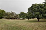
The place has aesthetic value as an area of mature, green landscape in this built up suburban area which is valued for passive and organised recreation. The place has historic value for its association with the establishment and development of Wembley in the 1930s. The place has historic value for its association with Angus Rutter who was an active campaigner to improve the facilities in the Wembley district. The place has social value for the community as the venue for formal and informal events since the 1930s.
A suburban park extending between Alexander Street and Jersey Street and located to the south of the Wembley Community Centre. The park has a central open grassed area with peripheral tree plantings. BBQ facilities, public art and children’s play area also contribute to the social nature of the space.
This portion of Wembley was subdivided for residential occupation in 1909 however there was sparse settlement in the area until the late 1920s. Originally known as Emerald Hill Estates and part of West Leederville, the name Wembley Park was formally approved in 1924. The name was taken from Wembley Park in London where the British Empire Exhibition was being held in 1924 and receiving much attention. The name was applied to the land west of McCourt Street. From the available information the Alexander Street Reserve was in existence in 1929 when Perth City Council allocated funds for playground equipment. However the park may have been established prior to that date. Wembley Park had a strong and active Progress Association which lobbied effectively for better services for the district. The Chairman of the Progress Association was Angus Wallis Rutter (c1883-1945) and the park was named in 1935 in recognition of his work. In 1939, the Perth City Council announced the works undertaken in the previous year in Perth's Open Spaces. Rutter Park, an area of four acres, was cleared, grassed, reticulated and planted with trees. In addition, a section with 'apparatus for games had been set aside for the smaller children'. The Council agreed at that time that a portion of the ground could be allocated for the Children's Protection Society for the erection of a clinic for the district. The Wembley Community Centre was built north of the park c1990 and facilities at the park continue to be updated as required. The park continues to be largely an informally landscaped area dominated by large trees.
Integrity: High Authenticity: High
Good
| Ref ID No | Ref Name | Ref Source | Ref Date |
|---|---|---|---|
| The West Australian, 9 July 1929, p14; 22 May 1935, p. 7; 5 January 1939; p. 14. | Newspaper | ||
| Town Planning Scheme | City of Perth | March 1935 | |
| Aerial Photographs | Landgate | ||
| Acc 3054; PCC File 1952/829 | PROWA;"Resumption of Land Alexander and Jersey Streets, Rutter Park". | City of Perth | 1944/5 |
| Wise's Post Office Directories for the City of Perth | Online Reference Documents |
| Reserve | Lot/Location | Plan/Diagram | Vol/Folio |
|---|---|---|---|
| 249 | Plan 3083 | ||
| 225 | Plan 3083 | ||
| 251 | Plan 3083 | ||
| 226 | Plan 3083 | ||
| 252 | Plan 3083 | ||
| 50 | Diagram 6623; |
| Owner | Category |
|---|---|
| Town of Cambridge | Local Gov't |
This information is provided voluntarily as a public service. The information provided is made available in good faith and is derived from sources believed to be reliable and accurate. However, the information is provided solely on the basis that readers will be responsible for making their own assessment of the matters discussed herein and are advised to verify all relevant representations, statements and information.
228 Jersey St Wembley
Cambridge
Metropolitan
| Type | Status | Date | Documents |
|---|---|---|---|
| (no listings) |
| Type | Status | Date | Documents |
|---|---|---|---|
| (no listings) |
| Type | Status | Date | Grading/Management | |
|---|---|---|---|---|
| Category | ||||
| Uniting Church Inventory | Completed | 01 Oct 1996 | ||
Individual Building or Group
| Epoch | General | Specific |
|---|---|---|
| Original Use | RELIGIOUS | Housing or Quarters |
| Present Use | RELIGIOUS | Housing or Quarters |
| Type | General | Specific |
|---|---|---|
| Roof | TILE | Ceramic Tile |
| Wall | BRICK | Common Brick |
| General | Specific |
|---|---|
| SOCIAL & CIVIC ACTIVITIES | Religion |
This information is provided voluntarily as a public service. The information provided is made available in good faith and is derived from sources believed to be reliable and accurate. However, the information is provided solely on the basis that readers will be responsible for making their own assessment of the matters discussed herein and are advised to verify all relevant representations, statements and information.
Lake Monger Dr Wembley
bound by Lake Monger Dr, Gregory St, Dodd St and Mitchell Fwy
Galup (Aboriginal name)
Cambridge
Metropolitan
| Type | Status | Date | Documents |
|---|---|---|---|
| Heritage List | Adopted | 27 Nov 2018 |
| Type | Status | Date | Documents |
|---|---|---|---|
| RHP - To be assessed | Current | 29 Sep 2007 |
| Type | Status | Date | Grading/Management | |
|---|---|---|---|---|
| Category | ||||
| Municipal Inventory | Adopted | 17 Dec 1996 | ||
| Municipal Inventory | Adopted | 27 Nov 2018 | Category 1 | |
The place has high significance as a traditional Aboriginal hunting, fishing and meeting place.
The place has high significance as a mythological site associated with the Waugal.
The place has archaeological potential to reveal further information about its Aboriginal occupation.
The place was an important site of recreation from the early 1900s, and continues to function in this role to the present.
The place has scientific value for its biodiversity.
The place is representative of the changes undergone by swamps in developing areas.
Positioned in an interdunal swale in the Spearwood dunes, Lake Monger Reserve is situated in a natural basin surrounded by urban land uses. The soils beneath the lake are peaty, consisting mainly of saturated organic material. The lake is part of the Perth group of wetlands which includes Big Carine Swamp and Lakes Gwelup, Jack adder and Herdsman. These lakes tend to have irregular elongated or regular circular shapes occupying depressions in the limestone dunes and occur at altitudes of less than 10 metres There is an avenue of Norfolk Island Pines and Phoenix Palms, planted around 1935, and a small group of weeping willow trees just south of the island to the west of the Lake. As part of the Lake Monger Reserve Rehabilitation Plan, exotic tree species (including trees from the eastern states) have been replaced by species indigenous to the local area, particularly along the eastern and south eastern areas of the lake. Some of these include Eucalyptus rudis and Melaleuca preisiana. Lake Monger has at least 33 species of waterbirds at the lake, twelve of which are breeding species. The lake is also an important habitat for transequatorial migratory waterbirds and those from inland water bodies which dry up in the summer. The black swan (Cygnus atratus) nests at the lake in high numbers and is known to nest at Herdsman Lake and bring the cygnets to Lake Monger to be reared on the lawn areas of the Reserve. Other birds found here include domestic ducks, the great crested grebe, Australian grebe, Australian pelican, great cormorant, Australian shelduck, purple swamp hen, red wattlebird, and the singing honeyeater. The lake is home to a large population of Western Long-necked Tortoises (Chelodina oblonga). The Large Skink (Egernia luctuosa), the Western Green and Gold Bell Frog (Litoria moorei) and the Banjo Frog (Limnodynastes dorsalis) also inhabit the area.
Prior to European settlement, Lake Monger was an Aboriginal camping, hunting and fishing ground, important for both food resources and mythological significance. Prehistoric occupation of the region is reflected in the presence of stone artefact scatters in the area, predating European occupation. It was in use until relatively recent times. DIA has four Aboriginal sites of significance recorded, and the lake and surrounding reserve are known to be a mythological site of current significance to Aboriginal people due to an association with the Waugal. Galup’s (Lake Monger) mythology ties it with the main Swan River Waugal saga. In the course of its journey to the sea, Waugal, deviated from his route and rose from the ground, thereby forming Lake Monger. On re-entering the ground, he cut a subterranean tunnel from the lake to Melville Water. This tunnel, according to tradition, still exists today. Galup was the place to which Yellagonga, leader of the Mooro people, moved his headquarters after European settlement. Lake Monger was the ‘capital’ of Yellagonga’s district of Mooro, which extended from the ocean to the Swan River and Melville Waters, Ellen Brook to the east and Gyngoorda to the north. In the 1860s, Aboriginal camps were located on the rising ground to the west and south of the lake, in the area where Harbourne and George Streets, and Lake Monger Drive and Kavanagh Street are now located. During this period, the lake was used as a source of turtle, mudfish, gilgies and wildfowl. Oral history reports a native burial ground said to be located on the sand hill on the north-western side of Leederville, near the present location of the Home of the Good Shepherd. With the gazetting of the lake in 1884 as a wildfowl reserve, there was increased European use of the southern shore. The traditional owners moved on, although the bush camp near Dodd and Powis Streets was still in use in 1923. There are records of Aborigines being supplied with food and clothing by the Good Shepherd Sisters in the early 20th century. Eventually, however, Aborigines abandoned the lake. Due to reclamation and modification of the lake, it is no longer possible to determine the dimensions of the original Aboriginal sites. The present day area of significance includes the lake itself and the open space surrounding it between Gregory Street, Powis Street, the Mitchell Freeway and Lake Monger Drive. This area, however, omits a large, but unidentified area of surrounding land now covered by urban development. When Europeans arrived, they found chains of small fresh-water lakes and salt-water lagoons. At this time, Monger’s Lake was grouped with Lakes Georgiana and Herdsman in what was known as ‘The Great Lakes District’. As Perth expanded, settlement moved to the north of the city. Lakes closer to the city were drained and reclaimed for their fertile soil. The land, taken up by artisans, discharged soldiers and small holders, was used to supply the town market. In the 1850s, plans to drain Lake Monger into Herdsman Lake and use the land to produce summer feed for cattle were abandoned when the land between the lakes was deemed unsuitable for the construction of a connecting drain. In 1887, St Kevin’s, an orphanage and industrial school for boys, was built to the north-west of the lake. It remained until 1921, when it was taken over by the Little Sisters of the Poor as a home for the aged. In 1908, the Home of the Good Shepherd, an industrial school for girls, was built opposite St Kevin's, close to St Joseph's orphanage which opened in the late 1800s. Although initially known as Large Lake and later as Triangle Lake, in October 1831 it was named after John Henry Monger, an early settler and pioneer, who received a crown grant of 200 acres of land to the south-east of the lake. It retained this name until being changed to Lake Monger in 1932. In January 1917, after two years of negotiation between the City of Perth and the Lands Department, a Government Grant of Monger's Lake Reserve was issued to the Perth City Council in trust for the purpose of a Public Park and Recreation. During the early 1900s, bathing sheds were established on the shores and a number of yacht clubs used the lake for regattas. Lake Monger was one of the principal aquatic resorts of the City during the early part of the century, with rowing, yachting and swimming facilities. In the 1920s the southern shore at the foot of Monger Street was further developed with a boat shed and refreshment kiosk at the foot of Lake Monger Street. The western shore was equally popular with two bathing sheds adjacent to a T-shaped jetty and two diving platforms about 20m offshore. During the Depression, the lake reached its height of popularity with sailing a common activity, as was fishing for perch, bream or carp. Prior to World War II, the lake gradually became more valued for its aesthetic appeal and less popular for boating and swimming. During the early years of settlement, swamps were seen as breeding grounds for mosquitoes, so reclaiming them to create parks was considered an improvement. The accepted method of reclamation involved the use of domestic and industrial rubbish. Using this method, reclamation of the lake commenced in 1907. The practice involved depositing rubbish in shallow layers, less than 6” deep, and sealing it completely with soil or sand. The heat produced within the rubbish was sufficient to destroy any disease in the refuse. However, the Council received numerous complaints from residents about the stench from the tip. Also of concern was the fear that the tip was detrimental to the health of adults and children living nearby. Due to the complaints and the fear of disease from flies breeding in the refuse, it was decided, in 1943, to cease the tipping of food stuffs at Lake Monger. Tipping continued around the lake until 1966, when complaints from residents finally saw a halt to tipping practices. By this time the lake area had been filled to the desired levels and rubbish was being deposited at the Hertha Road Tip. As a result, much of the area around the lake was reclaimed with rubbish. In places this is still only 2-3 feet below the surface. In 1917, Perth City Council assumed control of the lake. Earlier land grants meant there was no public land on the banks of Lake Monger, so it was decided to purchase privately owned land adjacent to the lake. 21 acres of land between Gregory Street and the lake's western bank was purchased from the Catholic Church in 1926. By 1931, 120 acres of land had been purchased. Also, a considerable area of swampy land on the south-eastern corner of the lake had been reclaimed with City refuse. When the land required for the development scheme had been purchased, a design layout for the lake was prepared. This development plan provided for a drive round the lake, sports grounds, children's playgrounds and tennis, bowling and croquet grounds. One section at the eastern end was to be developed as miniature lakes and waterways with rustic bridges. Other suggested features included rock gardens, lily ponds, aviary, maze, boating facilities and fountains, a refreshment kiosk, and a circular bandstand with choir reserve. In 1959, a comprehensive plan for the total lake area was developed, including a major road along the eastern edge of the (the present freeway) and associated playing fields housing areas. The shape of the lake in this plan is basically the same as the present shape except for the north-western corner and construction of the reed island in 1968. By the end of the 1960s, a large proportion of Lake Monger had been reclaimed by the disposal of city refuse. The shape of the lake had been drastically altered from an irregular swamp to a lake with a rounded shape closely resembling lakes in Europe. Much of the surrounding native vegetation had been removed and replaced with fertilised lawns, in order to reduce the nuisance of midges. In the late 1970's, the Mitchell Freeway was constructed along the Eastern bank of the lake. All works in relation to Lake Monger Rehabilitation Plan (1995) are now complete. The works program includes revegetating the lake with indigenous plant species, preventing eutrophication of the water, improving breeding habitats for birds and tortoises and the general health of the fauna and raising the profile of the lakes Aboriginal history. Storm water drains have been redesigned as vegetated nutrient filter channels. These channels are planted with high nutrient use plants to reduce nutrients entering the lake. The channels are also designed to capture rubbish and to slow the movement of water coming into the lake and in turn create a series of habitat refuges. Works programmed for 2007-08 include replacing the barbecue at the Dodd Street picnic area and the ongoing management of the bird refuge island and the vegetated channel.
| Library Id | Title | Medium | Year Of Publication |
|---|---|---|---|
| 11479 | Our Western Australian home: being sketches of scenery and society in the Colony | Heritage Study {Other} | 2016 |
Landscape
| Epoch | General | Specific |
|---|---|---|
| Original Use | GOVERNMENTAL | Reservoir or Dam |
| General | Specific |
|---|---|
| SOCIAL & CIVIC ACTIVITIES | Sport, recreation & entertainment |
| DEMOGRAPHIC SETTLEMENT & MOBILITY | Aboriginal Occupation |
This information is provided voluntarily as a public service. The information provided is made available in good faith and is derived from sources believed to be reliable and accurate. However, the information is provided solely on the basis that readers will be responsible for making their own assessment of the matters discussed herein and are advised to verify all relevant representations, statements and information.
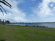
The place has aesthetic value as a large, well maintained landscape in the metropolitan area which is a landmark in the district. The place has historic and social value for the Whadjuk Noongar peoples who used the place for food, shelter and spiritual reasons. The place has historic value for its association with the early settlement of the district in the 1830s and particularly with the Monger family who leased this lake and its surrounds and provided the origin for the name. The place has historic value for its association with market gardens which operated close to the city of Perth in the 19th and 20th century. The place has historic value for its association with sports and recreation on the lake from the 19th century. The place has ongoing social value for the members of the community who have enjoyed the lake and its surrounds for passive recreation for many decades.
Monger Drive to the south and the Mitchell Freeway to the north east side of the lake. The Reserve totals 70 hectares which is predominantly occupied by the lake. Additional facilities include a walk trail around the lake, sporting facilities, visitor facilities and children’s play area. The lake is surrounded by flora and fauna, with a walk through the conservation area with boardwalks and lookouts across the lake. The south foreshore and the west side of the lake provide a grassy contrast to the lake and dense plantings along the north eastern side of the lake. The buildings within the grounds are representative of the post war period.
Prior to European settlement, the indigenous inhabitants of the south-west of Western Australia, were the Noongar, and Whadjuk is the name of the dialectal group from the Perth area. Given the abundance of wildlife and flora the lake was a hunting ground and campsite for the Whadjuk Noongar. As with most water bodies in the region the lake is associated with the Wagyl mythology. The myth describes the track of a serpent being who in his journey towards the sea, deviates from his route and emerges from the ground which gives rise to Lake Monger. The lake and a significant part of the reserve are registered with the Department of Indigenous Affairs as an Aboriginal heritage site. Previous research has indicated the area was called Keiermulu which translates to 'the home fires or camp' and the lake was Galup or Kalup. After European settlement, it became known as either Large Lake or Triangle Lake (based on its roughly triangular shape). By 1832, the lands around the lake had been subdivided into eight lots: a southern one was acquired by John Henry Monger and described as 200 acres [81 hectares] of Perthshire Location Ae abutting Lake Monger. Monger and his family left the landholding in 1836 and settled in York. In the latter half of the 20th century as the population increased with the arrival of convicts and later with the discoveries of gold in the colony, the land around the lake was used for market gardens. This was a common practice for the low lying swampy lands in the metropolitan region. While the swampy lands around the lake were utilised for market gardens the body of water was regularly used for recreation. Tragically several deaths occurred in the 19th and 20th century as a result of boating or swimming accidents. In 1902, the Leederville Council appointed a board to manage the lake. In 1908, the Waverley Boat Club was formed for sailing on the lake and in 1909, a drain was completed which connected the lake with the Swan River which allowed the water level to be managed and this drain is still [2018] in operation. In the early years of the 20th century the lake was popular for picnics and boating. A jetty and a bandstand was located near the junction with St Leonards Avenue. This jetty was later adopted by the Rover Scouts until boating ceased in 1938. In 1917, the lake and its surrounds were put under the administration of the City of Perth for use as a public park. Thereafter the Chinese market gardens and dairies which were operating around the lake were acquired by the City for public lands. By 1928, the gardeners were gone and by 1930, 50 hectares was under the control of the City of Perth to be developed as the Lake Monger Reserve. In 1932, dredging works began to reclaim land from the swamp and by June 1933. 110,000 tons (90718 tonnes) of silt had been pumped from the lake allowing 4.8 hectares of land to be reclaimed. As a reflection of the attitudes to swamp land at that time much of the fringing vegetation was removed and replaced with lawns. The southern shore of the lake was developed with a kiosk, bathing sheds, boat house and a jetty. At the completion of these works a celebration was held with a swim through, canoe race, a picnic and bonfires. The lake was used extensively for picnicking, yachting, swimming and fishing and further dredging was undertaken to enable more successful yachting. The Norfolk Island Pine Trees (Araucaria heterophylla) and Date Palms (Phoenix dactylifera which border the northern side of Lake Monger Drive are remnants from this beautification program. Reclamation of land continued into the 1930s with dumping of rubbish and raw sewage on the north east side of the lake. Not surprisingly by 1936 the quality of the water had deteriorated and infestations of midges were recorded. In the late 1930s, a series of drownings led to the decision to ban boating and swimming was discouraged. In the late 1950s, the 1955 Stephenson plan guided the decision to allocate a portion of the reserve for the future Mitchell Freeway which was built in the 1970s. During the 1960s a more widespread understanding of the environmental affect of past practices lead to the decision to build a small island in the south west corner of the lake to attract bird life back to the lake. Since then the lake and surrounding parklands have been managed more sensitively although issues of fertiliser run off from the surrounding suburbs is one of many issues which continue to be a challenge. In 1994, Lake Monger came under the management of the Town of Cambridge. The lake is now a popular destination for passive recreation and is well known for its regular and large population of black swans which are popular with tourists. Another popular feature of the lake are the Norfolk Island Pines aligning the northern boundary of Lake Monger Drive. For many decades, one of these large pine trees near the corner with Gregory Street is strung with lights to mark the festive season in December and January.
Integrity: High Authenticity: High
| Ref ID No | Ref Name | Ref Source | Ref Date |
|---|---|---|---|
| The West Australian | Newspaper | 27 September 1937 | |
| Stannage, C.T. The People of Perth, Perth City Council. | Book | 1979 | |
| B Gill & B Gay;"Remembering the Days..West Leederville Primary School 1898-1988". | AG O'Keefe & Son, Subiaco | 1988 | |
| Collard, L.; Revell, G.; Palmer, D.; Leonard, L. Noongar Placenames associated with the Goordandalup (Crawley bay) area of the Gabee Derbalor Derbal Yaragan Beloo (Swan River). | Report | 1999 | |
| Aerial Photographs, Landgate | Online Reference Documents | 1953-2016 | |
| "Lake Monger Management Plan, Part I- Background, City of Perth". | City of Perth | 1992 | |
| The West Australian, p. 18. | Newspaper | 8 August 1936 |
| Reserve | Lot/Location | Plan/Diagram | Vol/Folio |
|---|---|---|---|
| 100 | Plan 45962 | 2615-381 | |
| R8731 | 12663 | Plan 220075 | LR3138-224 |
| Owner | Category |
|---|---|
| Town of Cambridge | Local Gov't |
This information is provided voluntarily as a public service. The information provided is made available in good faith and is derived from sources believed to be reliable and accurate. However, the information is provided solely on the basis that readers will be responsible for making their own assessment of the matters discussed herein and are advised to verify all relevant representations, statements and information.
59 Lake Monger Dr Wembley
Cambridge
Metropolitan
Constructed from 1970
| Type | Status | Date | Documents |
|---|---|---|---|
| (no listings) |
| Type | Status | Date | Documents |
|---|---|---|---|
| (no listings) |
| Type | Status | Date | Grading/Management | |
|---|---|---|---|---|
| Category | ||||
| Catholic Church Inventory | Adopted | 01 Jul 1998 | ||
good
Individual Building or Group
| Epoch | General | Specific |
|---|---|---|
| Present Use | RELIGIOUS | Housing or Quarters |
| Original Use | RESIDENTIAL | Single storey residence |
| Type | General | Specific |
|---|---|---|
| Roof | TILE | Ceramic Tile |
| Wall | BRICK | Common Brick |
| General | Specific |
|---|---|
| SOCIAL & CIVIC ACTIVITIES | Religion |
This information is provided voluntarily as a public service. The information provided is made available in good faith and is derived from sources believed to be reliable and accurate. However, the information is provided solely on the basis that readers will be responsible for making their own assessment of the matters discussed herein and are advised to verify all relevant representations, statements and information.
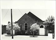
61-61A Nanson St Wembley
Cambridge
Metropolitan
Constructed from 1939
| Type | Status | Date | Documents |
|---|---|---|---|
| Heritage List | Adopted | 27 Nov 2018 |
| Type | Status | Date | Documents |
|---|---|---|---|
| (no listings) |
| Type | Status | Date | Grading/Management | |
|---|---|---|---|---|
| Category | ||||
| Municipal Inventory | Adopted | 27 Nov 2018 | Category 3 | |
| Municipal Inventory | Adopted | 17 Dec 1996 | ||
Individual Building or Group
| Epoch | General | Specific |
|---|---|---|
| Present Use | RELIGIOUS | Church, Cathedral or Chapel |
| Original Use | RELIGIOUS | Church, Cathedral or Chapel |
| Type | General | Specific |
|---|---|---|
| Wall | BRICK | Common Brick |
| Roof | TILE | Ceramic Tile |
| General | Specific |
|---|---|
| SOCIAL & CIVIC ACTIVITIES | Religion |
This information is provided voluntarily as a public service. The information provided is made available in good faith and is derived from sources believed to be reliable and accurate. However, the information is provided solely on the basis that readers will be responsible for making their own assessment of the matters discussed herein and are advised to verify all relevant representations, statements and information.
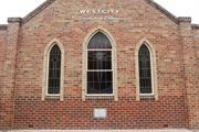
Constructed from 1960 to 1970, Constructed from 1939, Constructed from 1950 to 1960
The place has aesthetic value as a simple expression of the Inter War Gothic style expressed in brick and tile. The place is a landmark in the community and streetscape for its continuity of presence and function since the 1939. The place has historic value for its association with the establishment and development of the Wembley community in the Inter War years. The place has social value to the members of the Wembley Church of Christ and the wider community who have attended services and social events at the venue since 1939.
Simple brick church constructed during the early days of World War Two. The place is of simple construction with symmetrical façade incorporating a gabled central section with three arched stained glass windows flanked by entrance wings, each with arched door openings with stained glass windows and double timber doors and parapet walls. The larger body of the church sites to the rear of the entry section with a larger gabled element projecting above the front gable. The entrance section appears to have been constructed at a later date, circa late 1950s-early 1960s. The brick to the entrance is a paler brick than the main body of the church. The main section of the church sits on a limestone plinth and is divided into bays by capped buttresses, each bay containing an arched window. The end bay on the north wall has an arched door opening with brick stepped access and skillion canopy. The church hall extends from the rear of the church on a north west axis, located at the rear of the lot. The hall was constructed in the 1960s. Hard standing for use as parking has been laid to the north of the church.
The Church of Christ had a presence in the Wembley community since the 1930s. A Church of Christ Sunday School was established at the Wembley School in 1937. This portion of Wembley was being steadily developed in the Inter War years and the Church of Christ acquired three lots in Nanson Street for their community. The building of the church was driven by David Moffat Wilson (c1860-1943) who at 80 years of age, laid the foundation stone of the church on 2nd September 1939 and was the first Secretary for the church. The first evening preacher was A.G. Elliott. The expected cost of construction was £1000 and overseen by builder Mr F Nash. The stained glass windows were made by Mr Whittome. No architect has been identified in this research. The Church did not have a dedicated minister for the parish until 1945 when Mr A.G. Whiting was appointed to the church. The porch entry to the church is a later addition as is the addition to the rear of the brick church is apparent in a 1953 aerial photograph. By 1964, the large hall across the rear of the lot was present. The roof form of the hall and church extension were of a lower pitch to the main church and appeared to be roofed in asbestos. There have been few changes to the extent and form of the buildings on the site since the mid 20th century. A narrow addition was constructed on the southern elevation of the hall and church addition in c1990, and in mid 2009 the roof cladding of these later additions were changed to red colorbond sheeting. In early 2016, the hall roof was reclad with zincalume. The original church form and extent do not appear to have been significantly altered since construction although as noted previously the light brick addition to the porch does not appear to be original. The residence to the south of the church appears to be the premises for the minister of the church.
Integrity: High Degree Authenticity: Moderate Degree
Good
| Ref ID No | Ref Name | Ref Source | Ref Date |
|---|---|---|---|
| Wise's Post Office Directories for the City of Perth | Online Reference | 1925-1949 | |
| The West Australian, p.4. | Newspaper | 27 January 1945 |
| Reserve | Lot/Location | Plan/Diagram | Vol/Folio |
|---|---|---|---|
| 1 | Diagram 56193 | 1527-651 |
| Owner | Category |
|---|---|
| Church of Christ | Church Property |
This information is provided voluntarily as a public service. The information provided is made available in good faith and is derived from sources believed to be reliable and accurate. However, the information is provided solely on the basis that readers will be responsible for making their own assessment of the matters discussed herein and are advised to verify all relevant representations, statements and information.
35 Pangbourne St Wembley
Wembley Methodist Church
Cambridge
Metropolitan
Constructed from 1955
| Type | Status | Date | Documents |
|---|---|---|---|
| Heritage List | Adopted | 27 Nov 2018 |
| Type | Status | Date | Documents |
|---|---|---|---|
| (no listings) |
| Type | Status | Date | Grading/Management | |
|---|---|---|---|---|
| Category | ||||
| Municipal Inventory | Adopted | 17 Dec 1996 | ||
| Municipal Inventory | Adopted | 27 Nov 2018 | Category 3 | |
| Uniting Church Inventory | Completed | 01 Oct 1996 | ||
Individual Building or Group
| Epoch | General | Specific |
|---|---|---|
| Present Use | RELIGIOUS | Church, Cathedral or Chapel |
| Original Use | RELIGIOUS | Church, Cathedral or Chapel |
| Type | General | Specific |
|---|---|---|
| Roof | TILE | Ceramic Tile |
| Wall | BRICK | Common Brick |
| General | Specific |
|---|---|
| SOCIAL & CIVIC ACTIVITIES | Religion |
This information is provided voluntarily as a public service. The information provided is made available in good faith and is derived from sources believed to be reliable and accurate. However, the information is provided solely on the basis that readers will be responsible for making their own assessment of the matters discussed herein and are advised to verify all relevant representations, statements and information.
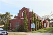
Constructed from 1941, Constructed from 1992, Constructed from 1955
The place has aesthetic value for the remaining form and detail of its original construction in 1941 in the Inter War Gothic style. The place has aesthetic value as a landmark in the streetscape since 1941. The place has historic value for its association with the Methodist Church and later the Uniting Church in the developing residential areas of Wembley throughout the 20th century. The place has social value for the members of the community who attended the place as the Methodist and Uniting Church throughout the 20th century for social or religious occasions.
A brick and tile church with distinctive frontage. The church is single storey with steep pitched roof and double height parapet wall to the Pangbourne Street elevation. The main feature of the wall is the arched window with herringbone brick detailing. The front porch section of the church is a later addition, it consists of a single storey section with parapet wall and flat roof. The central section contains a glass brick window, flanked by slightly recessed walls each with a small glazed window. The side elevations of the main body of the church are divided into bays by brick columns with each bay containing a stained glass casement window. A brick addition has been constructed to the rear to provide hall facilities, presenting with a similar design aesthetic incorporating high brick parapet walls with concrete capping and few adornments.
The first Methodist Church in Wembley was held in a private home in 1917. In 1921, the timber Bullfinch Methodist Church building was purchased for £50 plus 7% interest, and railed to the site. The building was erected on the site throughout 1922 with volunteer labour and opened in February 1923. This building was built to the rear of the lot and functioned as the church until the growth of the congregation demanded a larger building. The Wembley Methodist Church resolved to build a new church on the front of the lot and plans were prepared by parishioner Ronald Escort Turner (1911-1985). The plans were submitted to the City of Perth and that document states the builders were Sampson & Kempin. Ron Turner was identified as the architect on these plans but he designated his occupation as an architectural surveyor in the Electoral Rolls of 1937 and 1943. It is probable that he was not a registered architect but an experienced builder. It is recorded in the history of the church that 'Mr Ron Turner, a church member and a contract builder, unselfishly gave up six months of his accrued long service leave to organise the building of the church'. It is not clear what role building contractors Sampson & Kempin took in this project. On 15th March 1941, a foundation stone for a new church was laid by Miss Mildred Grigg who had started the Wembley Sunday School in 1917. An account in the local press stated that the new brick church would accommodate 200 people. Fundraising for the new church was undertaken by the local community and Miss Mildred Grigg was prominent in this effort, notably organising musical evenings in the existing church. On 31 May 1941, the Wembley Methodist Church was opened and dedicated. The opening was undertaken by Mrs W.G.Hyde, the widow of Rev W.G.Hyde, a former conference president associated with Wembley. The dedication was performed by Rev R.H. Mason representing the President of the conference. In this news item it was noted that the church would seat 150 so perhaps plans for the size of the church changed during construction. At the time of construction the main entry was at the front of the porch, facing Pangbourne Street. In 1955, the original timber church was demolished and a new brick hall and minister's vestry were built. These new structures were linked to the church. Sometime after these additions, the entry to the church was moved to the south side of the porch. In 1992, the front porch was further altered to provide a larger foyer area and an additional 'baby's room' at the side of the foyer. Since that time the form and extent of the church building has not been altered significantly. In 1977, three Australian churches came together, Presbyterian, Methodist and Congregational churches as the Uniting Church in Australia. This church was renamed the Wembley Uniting Church following this union.
Integrity: High Authenticity: Moderate
Good
| Ref ID No | Ref Name | Ref Source | Ref Date |
|---|---|---|---|
| The West Australian, 17 March 1941, p. 2; 20 May 1941, p. 3. | Newspaper | 1941 | |
| Centenary History of the Wembley Uniting Church, John Meyer | Website Document | June 2017 | |
| Wise's Post Office Directories for the City of Perth | Online Document | 1940-1949 | |
| Aerial photographs, Landgate. | Online Reference | 1953-2016 | |
| A Church in Retrospect: the story of 75 years of worship and witness in Wembley Uniting (formerly Methodist) Church | Book | ||
| M Putt;"Wembley, It's People and It's Past". | City of Perth | 1990 |
| Reserve | Lot/Location | Plan/Diagram | Vol/Folio |
|---|---|---|---|
| 314 | Plan 3083 | 682-23 |
| Owner | Category |
|---|---|
| Uniting Church in Australia Property Trust | Church Property |
This information is provided voluntarily as a public service. The information provided is made available in good faith and is derived from sources believed to be reliable and accurate. However, the information is provided solely on the basis that readers will be responsible for making their own assessment of the matters discussed herein and are advised to verify all relevant representations, statements and information.
54 Pangbourne St Wembley
Cambridge
Metropolitan
Constructed from 1952
| Type | Status | Date | Documents |
|---|---|---|---|
| Heritage List | Adopted | 27 Nov 2018 |
| Type | Status | Date | Documents |
|---|---|---|---|
| (no listings) |
| Type | Status | Date | Grading/Management | |
|---|---|---|---|---|
| Category | ||||
| Municipal Inventory | Adopted | 27 Nov 2018 | Category 2 | |
| Municipal Inventory | Adopted | 17 Dec 1996 | ||
| Anglican Church Inventory | YES | 31 Jul 1996 | ||
| Name | Type | Year From | Year To |
|---|---|---|---|
| L. Williams | Architect | - | - |
Individual Building or Group
| Epoch | General | Specific |
|---|---|---|
| Present Use | RELIGIOUS | Church, Cathedral or Chapel |
| Original Use | RELIGIOUS | Church, Cathedral or Chapel |
| Type | General | Specific |
|---|---|---|
| Wall | BRICK | Common Brick |
| Roof | TILE | Ceramic Tile |
| General | Specific |
|---|---|
| SOCIAL & CIVIC ACTIVITIES | Religion |
This information is provided voluntarily as a public service. The information provided is made available in good faith and is derived from sources believed to be reliable and accurate. However, the information is provided solely on the basis that readers will be responsible for making their own assessment of the matters discussed herein and are advised to verify all relevant representations, statements and information.
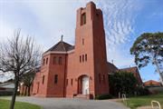
Constructed from 1952
The church has aesthetic value as a good intact example of the post war international style executed in brick and tile featuring stained glass and original internal features. The church has aesthetic value as a landmark in the street and district. The place has historic value for its association with the development of Wembley in the 1950s. The place has historic value for its association with the development of the Anglican community in Wembley since 1917. The place has social value for the members of the community who have attended the place for social and religious occasions since 1955.
Large brick church located in a residential street and close to another church on the same road. The church makes a striking contribution to the streetscape through design, siting and scale. The place is of red brick construction with hipped roof to the main body of the church and faceted hip to the apse. A square tower of brick construction with turrets is constructed to the south west corner of the façade. The tower is mainly a blank brick elevation with only three very narrow leaded windows and an 'arrow slit' above recessed door and louver breaking up the brickwork. The faceted apse is the main feature of the Pangbourne Street façade, creating an interesting feature in the streetscape. The rose window is on the east elevation and can be seen from Crofts Lane, and demonstrates the traditional use of tracery in the design.
The first Anglican Church in Wembley was constructed in 1917 of timber on land overlooking Herdsman Lake between Marlowe and Simper Streets. A new timber church was constructed in 1930 in Pangbourne Street (now the site of a nursing home). A new parish of Jolimont-Wembley was formed in 1943. A new church was designed by architect Louis Williams of Melbourne, however it was not constructed until 1954/5 due to financial difficulties. A foundation stone was laid by Archbishop Dr R.W.H. Moline on Sunday 24 August 1952. Delays in building were also affected by the difficulties in sourcing building materials in the post war period for non essential construction. Louis Reginald Williams (1890-1980) was an ecclesiastical architect who designed churches throughout the country, particularly in Victoria, primarily Anglican but also Methodists, Presbyterians, Lutherans and Christian Scientists. Williams was probably the major church architect in Australia in the Arts and Crafts tradition from the 1920s to the 1970s. A description of the church in the local press in June 1954 stated that the church would cost £35,000. A second stage of a tower and chapel on the north of the church was estimated to cost between £8000 and £9000. St Edmunds was consecrated in 1956 by the Archbishop of Perth Cr Moline. The name of St Edmund's Church originates with Saint Edmund, king of East Anglia, born about 840; died at Hoxne, Suffolk, 20th November, 870. The Anglican Diocese of Perth secured four lots in Pangbourne Street for the property with the intent that the adjacent lots would be used for a hall and rectory. The church hall was built to the north of the church c1970 and the rectory on the south of the church was built at approximately the same time as the church. Since construction the form and extent of the church building has not changed significantly. In 2004, the church hall was renamed the Jack Watts Memorial Hall in honour of Canon Jack Watts (1952-1975) who oversaw the construction of St Edmund's Church. The hall is not included in the assessment.
Integrity: High Authenticity: High
Good
| Name | Type | Year From | Year To |
|---|---|---|---|
| Louis Reginald Williams | Architect | 1952 | - |
| Ref ID No | Ref Name | Ref Source | Ref Date |
|---|---|---|---|
| St Edmund's Anglican Church History | Website | 2018 | |
| M Putt;"Wembley, It's People and It's Past". | City of Perth | 1990 | |
| Aerial photographs, Landgate. | Online Reference | 1953-2016 |
| Reserve | Lot/Location | Plan/Diagram | Vol/Folio |
|---|---|---|---|
| 359 | Plan 3083 | 1053/291 | |
| 358 | Plan 3083 | 1053/291 | |
| 357 | Plan 3083 | 1053/291 |
| Owner | Category |
|---|---|
| Perth Diocesan Trustees | Church Property |
This information is provided voluntarily as a public service. The information provided is made available in good faith and is derived from sources believed to be reliable and accurate. However, the information is provided solely on the basis that readers will be responsible for making their own assessment of the matters discussed herein and are advised to verify all relevant representations, statements and information.
64 Reserve St Wembley
Cambridge
Metropolitan
Constructed from 1920
| Type | Status | Date | Documents |
|---|---|---|---|
| (no listings) |
| Type | Status | Date | Documents |
|---|---|---|---|
| (no listings) |
| Type | Status | Date | Grading/Management | |
|---|---|---|---|---|
| Category | ||||
| Municipal Inventory | Adopted | 27 Nov 2018 | Category 4 | |
| Municipal Inventory | Adopted | 17 Dec 1996 | ||
A fine example of a large house constructed in Wembly in the Inter-War years. It reflects the promotion and settlement of the area during the 1920. When land in the Pertshire Estate (Wembly) was advertised for sale, it was promoted as an area with views over Herdsman Lake. Accordingly higher land was more prestigious affording views of the lake. It is likely that two properties in Reserve Street (Nos 64 & 65) were developed with this in mind.
Individual Building or Group
| Epoch | General | Specific |
|---|---|---|
| Original Use | RESIDENTIAL | Single storey residence |
| Present Use | RESIDENTIAL | Two storey residence |
| Style |
|---|
| Inter-War Old English |
| Type | General | Specific |
|---|---|---|
| Wall | RENDER | Other Render |
| Roof | TILE | Ceramic Tile |
| General | Specific |
|---|---|
| DEMOGRAPHIC SETTLEMENT & MOBILITY | Settlements |
| DEMOGRAPHIC SETTLEMENT & MOBILITY | Land allocation & subdivision |
This information is provided voluntarily as a public service. The information provided is made available in good faith and is derived from sources believed to be reliable and accurate. However, the information is provided solely on the basis that readers will be responsible for making their own assessment of the matters discussed herein and are advised to verify all relevant representations, statements and information.
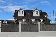
Constructed from 1922
The place has aesthetic value as a good intact example of the Inter War Old English style executed in brick which has retained original details. The place has historic value for its association with the establishment and development of this part of Wembley in the Inter War years. The place has social and historic value as an example of a home for a professional man and his family in the Inter War period.
A large house which presents as single storey with additional accommodation in the roof space. The house has a symmetrical façade with a centrally placed entrance flanked by timber framed 3-section windows. The roof is gabled, clad in a dark tile with two large dormer windows which is not an original feature of the house. The roof is steeply pitched which continues down to form the verandah canopy at the same pitch. The verandah extends across the full extent of the façade with the canopy supported on masonry piers with timber posts. The house is sited in an elevated position.
When land in the Perthshire Estate (Wembley) was advertised for sale, it was promoted as an area with views over Herdsman Lake. Accordingly higher land on the eastern side of Reserve Street was more prestigious affording views of the lake. From the available information this lot was not developed until a residence was built on this large land parcel of two lots for Paul Albert Meyer and his wife Elfrieda Agnes, nee Hufner. Paul Meyer was a piano mechanic or tuner and he worked with the family company Meyer and Orr which sold and repaired pianos in Western Australia in the first half of the 20th century. The house adjacent to this (66 Reserve St) was owned and occupied by business partner William Orr. No details of the architect or builder of this place have been found in this research. Paul and Elfrieda Meyer lived at the house until the mid 1950s. Aerial photographs indicate the form and extent of the residence has not changed significantly since the mid 20th century. The tennis court has been evident on the property since that time. The most significant changes occurred in the period between 1985 and 1995 when a new garage was built on the front property boundary and the roof cladding was changed from terracotta tile to the current dark tile. This change in roof cladding was undertaken when new dormers were added to the roof to the front and rear. The original roof included only one dormer central to the main elevation.
Integrity: High Authenticity: Moderate
Good
| Ref ID No | Ref Name | Ref Source | Ref Date |
|---|---|---|---|
| Wise's Post Office Directories for the City of Perth | SLWA Online Reference | 1920-1949 | |
| M Putt;"Wembley, It's Peopl and It's Past". | UWA Press | 1990 |
| Reserve | Lot/Location | Plan/Diagram | Vol/Folio |
|---|---|---|---|
| 442, 443 | Plan 3185 | 2228-779/780 |
| Owner | Category |
|---|---|
| Private owners | Other Private |
This information is provided voluntarily as a public service. The information provided is made available in good faith and is derived from sources believed to be reliable and accurate. However, the information is provided solely on the basis that readers will be responsible for making their own assessment of the matters discussed herein and are advised to verify all relevant representations, statements and information.
66 Reserve St Wembley
Cambridge
Metropolitan
Constructed from 1920
| Type | Status | Date | Documents |
|---|---|---|---|
| Heritage List | Adopted | 27 Nov 2018 |
| Type | Status | Date | Documents |
|---|---|---|---|
| (no listings) |
| Type | Status | Date | Grading/Management | |
|---|---|---|---|---|
| Category | ||||
| Municipal Inventory | Adopted | 27 Nov 2018 | Category 3 | |
| Municipal Inventory | Adopted | 17 Dec 1996 | ||
Individual Building or Group
| Epoch | General | Specific |
|---|---|---|
| Present Use | RESIDENTIAL | Single storey residence |
| Original Use | RESIDENTIAL | Single storey residence |
| Style |
|---|
| Federation Arts and Crafts |
| Type | General | Specific |
|---|---|---|
| Wall | BRICK | Common Brick |
| Roof | METAL | Corrugated Iron |
| General | Specific |
|---|---|
| DEMOGRAPHIC SETTLEMENT & MOBILITY | Settlements |
This information is provided voluntarily as a public service. The information provided is made available in good faith and is derived from sources believed to be reliable and accurate. However, the information is provided solely on the basis that readers will be responsible for making their own assessment of the matters discussed herein and are advised to verify all relevant representations, statements and information.
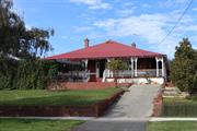
Constructed from 1920
The place has aesthetic value as a good intact example of the Inter War Arts and Crafts style executed in brick which has retained original details. The place has historic value for its association with the establishment and development of this part of Wembley in the Inter War years. The place has social and historic value as an example of a home for a professional man and his family in the Inter War period.
Single storey brick house of traditional design and planform. The hipped roof has been reclad with colorbond, retaining the two red brick chimneys. The roof continues down with a slight break of pitch to form the verandah canopy. The verandah extends around the house, accessed via steps from the front and supported on a rendered masonry retaining wall. The deck is timber, with a simple timber balustrade and timber posts supporting the canopy. The house has a symmetrical façade, the centrally placed entrance consists of single door with side panels and lights and fanlight across the entire in a traditional form. The entrance is flanked by three-section timber framed windows with integral highlight panes
When land in the Perthshire Estate (Wembley) was advertised for sale, it was promoted as an area with views over Herdsman Lake. Accordingly higher land on the eastern side of Reserve Street was more prestigious affording views of the lake. From the available information this lot was not developed until a residence was built c1922 for William Joseph Orr (1882-1926) and his wife Isabella Reed, nee Spowart and their five children. William Orr was a piano mechanic or tuner and he worked with the family company Meyer and Orr which sold and repaired pianos in Western Australia in the first half of the 20th century. The house adjacent to this (64 Reserve St) was owned and occupied by business partner Paul Meyer. No details of the architect or builder of this place have been found in this research. William Orr died in 1926 and his widow Isabella lived on in the house until the late 1960s. It is noted that a member of the Orr family lived at 62 Reserve Street for some years. Aerial photographs indicate that the form and extent of the residence have not changed since the mid 20th century although minor changes are apparent in the property grounds.
Integrity: High Authenticity: Moderate
Good
| Ref ID No | Ref Name | Ref Source | Ref Date |
|---|---|---|---|
| Wise's Post Office Directories for the City of Perth | Online Reference | 1919-1949 | |
| M Putt;"Wembley, It's People and It's Past". | City of Perth | 1990 | |
| Aerial Photographs | Landgate | 1953-2016 |
| Reserve | Lot/Location | Plan/Diagram | Vol/Folio |
|---|---|---|---|
| 441 | Plan 3185 | 2-254A |
| Owner | Category |
|---|---|
| Private owners | Other Private |
This information is provided voluntarily as a public service. The information provided is made available in good faith and is derived from sources believed to be reliable and accurate. However, the information is provided solely on the basis that readers will be responsible for making their own assessment of the matters discussed herein and are advised to verify all relevant representations, statements and information.