Local Government
Kalamunda
Region
Metropolitan
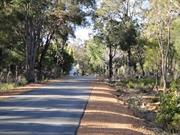
Hacket Gully, Mundaring Wier Road, Kalamunda
Kalamunda
Metropolitan
| Type | Status | Date | Documents |
|---|---|---|---|
| (no listings) |
| Type | Status | Date | Documents |
|---|---|---|---|
| RHP - Does not warrant assessment | Current | 27 Jul 2018 |
| Type | Status | Date | Grading/Management | |
|---|---|---|---|---|
| Category | ||||
| (no listings) | ||||
• The place is a demonstration of the widespread use of timber as a structural material in the early twentieth century.
• The place is associated with the growth of regional infrastructure in the early twentieth century, particularly with the development of the Perth Hills as a recreation area.
Bridge 828 over Hackett Gully, Mundaring Weir Road is a double lane timber, steel and concrete road bridge spanning Hackett Gully east of Kalamunda. The bridge is approximately 6.1 m long, 8.6 m wide and sits approximately 1 m above the gully bed. The trestle bridge consists of a single span constructed along a north-south axis. The bridge abutments consist of round timber logs laid on top of each other against the soil with cement and masonry wing walls, topped by modern concrete. The original bridge deck is not visible but is assumed to be timber planks, set onto a series of sawn timber stringers set between the abutments. The outer edges of the span are protected by galvanised steel plates.
The economic policies of the Western Australian government during the 1920s can be described as broadly expansionist, in particular agricultural and pastoral expansion. However, these policies suffered severe contraction due to droughts and the effects of the Great Depression. At the end of the 1920s and into the early 1930s, the government responded in a number of ways, including stimulating the building market and investing in the expansion of industrial development such as the mining industry or capital works projects such as dams, sewerage, clearing and roads. The development of roads became particularly important as families migrated to Perth seeking work, resulting in rapid urbanisation. The Main Roads Board was established in 1926, taking over some of the responsibilities of the Public Works Department. The board was re-established as the Main Roads Department in 1930. Main Roads became an active part of the state’s response to the economic crisis, providing short-term work for unemployed on a variety of infrastructure projects, even while struggling to cut costs and staff within their own structure. These works included road works and bridgeworks, with a focus on the southwest of the state. Timber trestle bridges were a common sight since the early days of the Swan River Colony as timber was easily obtainable and fire-resistant. As such the use of concrete for abutments and as a foundation structure was still relatively unknown in the inter-war period.
Other Built Type
This information is provided voluntarily as a public service. The information provided is made available in good faith and is derived from sources believed to be reliable and accurate. However, the information is provided solely on the basis that readers will be responsible for making their own assessment of the matters discussed herein and are advised to verify all relevant representations, statements and information.
Kalamunda Rd, Perth Airport Belmont
approx 297 ha ALSO IN KALAMUNDA SHIRE
approx 297 ha
Swan
Metropolitan
| Type | Status | Date | Documents |
|---|---|---|---|
| Commonwealth List | YES |
| Type | Status | Date | Documents |
|---|---|---|---|
| (no listings) |
| Type | Status | Date | Grading/Management | |
|---|---|---|---|---|
| Category | ||||
| Register of the National Estate | Permanent | 26 Oct 1999 | ||
04560 Perth Airport Bushland
Large Conservation Region
| Epoch | General | Specific |
|---|---|---|
| Original Use | PARK\RESERVE | Park\Reserve |
| Present Use | PARK\RESERVE | Park\Reserve |
This information is provided voluntarily as a public service. The information provided is made available in good faith and is derived from sources believed to be reliable and accurate. However, the information is provided solely on the basis that readers will be responsible for making their own assessment of the matters discussed herein and are advised to verify all relevant representations, statements and information.
226 Aldersyde Rd Bickley
Woodhenge
Kalamunda
Metropolitan
Constructed from 1919
| Type | Status | Date | Documents |
|---|---|---|---|
| (no listings) |
| Type | Status | Date | Documents |
|---|---|---|---|
| (no listings) |
| Type | Status | Date | Grading/Management | |
|---|---|---|---|---|
| Category | ||||
| Municipal Inventory | Adopted | 01 Aug 2013 | Category 4 | |
Individual Building or Group
| Epoch | General | Specific |
|---|---|---|
| Original Use | RESIDENTIAL | Single storey residence |
| Present Use | INDUSTRIAL\MANUFACTURING | Winery |
| Type | General | Specific |
|---|---|---|
| Wall | TIMBER | Weatherboard |
| Wall | CONCRETE | Concrete Block |
| General | Specific |
|---|---|
| OCCUPATIONS | Grazing, pastoralism & dairying |
This information is provided voluntarily as a public service. The information provided is made available in good faith and is derived from sources believed to be reliable and accurate. However, the information is provided solely on the basis that readers will be responsible for making their own assessment of the matters discussed herein and are advised to verify all relevant representations, statements and information.
Constructed from 1919
· The site has historic value for its association with the soldier settlement scheme and for its association with the establishment of the wine industry in the region
Original 1919 house now demolished. Winery is housed in a shed of simple form and construction, built from concrete blocks with weatherboard gables and corrugated metal gabled roof. There is an addition to the NE elevation built of similar construction. Further skillion roofed section on the north elevation (an enclosed former verandah) of timber framed and weatherboard construction on a stone base. Additional plant and machinery located around the building. To the south of the main shed/winery a more modern building of brick construction with a dominant glazed façade. The built form is constructed on the rise of the land with views over the vines on the lower scarps.
Level of Integrity - Moderate; Level of Authenticity - Low
Good At the end of the First World War, the discharged Soldiers Settlement Act of 1918 initiated a scheme to settle returned soldiers on the land. One of the areas chosen for settlement was along the Piesse Brook. In order to establish their orchards, settlers relied on loans and advanced payments from the Agricultural Bank. Since fruit trees took five years or more to bear enough fruit to sell, settlers often found it impossible to meet loan repayments and the scheme foundered. The Great Depression increased the burden and the Government was forced to foreclose on many of the properties. This landholding was one of the first soldier settlement properties. It was taken up by Harry Bateman in 1919. The house Bateman built was demolished and the materials used by subsequent owner Mick Boyanich, one of the first settlers in the district originally from central Europe. The property was the first commercial vineyard in the area starting in 1974.
| Ref ID No | Ref Name | Ref Source | Ref Date |
|---|---|---|---|
| Keast J; "Ancient Orchard Architecture". | Bill Shaw Award entry, | 1989 |
| Reserve | Lot/Location | Plan/Diagram | Vol/Folio |
|---|---|---|---|
| Lot 731 | P202158 | 1372-877 |
This information is provided voluntarily as a public service. The information provided is made available in good faith and is derived from sources believed to be reliable and accurate. However, the information is provided solely on the basis that readers will be responsible for making their own assessment of the matters discussed herein and are advised to verify all relevant representations, statements and information.
250 Aldersyde Rd Bickley
Dell's home
Kalamunda
Metropolitan
Constructed from 1921
| Type | Status | Date | Documents |
|---|---|---|---|
| (no listings) |
| Type | Status | Date | Documents |
|---|---|---|---|
| (no listings) |
| Type | Status | Date | Grading/Management | |
|---|---|---|---|---|
| Category | ||||
| Municipal Inventory | Adopted | 01 Aug 2013 | Category 3 | |
Individual Building or Group
| Epoch | General | Specific |
|---|---|---|
| Original Use | RESIDENTIAL | Single storey residence |
| Present Use | RESIDENTIAL | Single storey residence |
| Type | General | Specific |
|---|---|---|
| Roof | METAL | Corrugated Iron |
| Wall | TIMBER | Weatherboard |
| General | Specific |
|---|---|
| DEMOGRAPHIC SETTLEMENT & MOBILITY | Settlements |
This information is provided voluntarily as a public service. The information provided is made available in good faith and is derived from sources believed to be reliable and accurate. However, the information is provided solely on the basis that readers will be responsible for making their own assessment of the matters discussed herein and are advised to verify all relevant representations, statements and information.
Constructed from 1921
· The place has historic value for its association with the establishment and development of the district · The place has social value as an example of the type of housing built in rural areas in the inter-war period for farming families
Timber framed and weatherboard /fibro construction. Hipped roof with short sheet corrugated metal roof and chimney located on the raised roof ridge. Symmetrical façade with French doors flanking the centrally placed main entrance. The verandah wraps around the building which has been partially enclosed with fibro panelling.
Level of Integrity - Low; Level of Authenticity - Low
Poor At the end of the First World War, the discharged Soldiers Settlement Act of 1918 initiated a scheme to settle returned soldiers on the land. One of the areas chosen for settlement was along the Piesse Brook. In order to establish their orchards, settlers relied on loans and advanced payments from the Agricultural Bank. Since fruit trees took five years or more to bear enough fruit to sell, settlers often found it impossible to meet loan repayments and the scheme foundered. The Great Depression increased the burden and the Government was forced to foreclose on many of the properties. This cottage is typical of the simple weatherboard cottages built for the returned soldiers under the scheme. Walter Palmer served in France in the AIF as a private and returned to Western Australian in 1919. Walter and Evelyn Palmer married in 1921 and this cottage was built in the same year. Walter Palmer (1896-1937) worked as an orchardist and market gardener but it was noted on his enlistment papers that he was also a vigneron. The couple had at least two sons whilst living at the property they named 'Drascombe'. The property was later owned by several other individuals, including; Burke, Cockles and Dell.
| Reserve | Lot/Location | Plan/Diagram | Vol/Folio |
|---|---|---|---|
| Lot 754 | P202158 | 1330-682 |
This information is provided voluntarily as a public service. The information provided is made available in good faith and is derived from sources believed to be reliable and accurate. However, the information is provided solely on the basis that readers will be responsible for making their own assessment of the matters discussed herein and are advised to verify all relevant representations, statements and information.
251 Aldersyde Rd Bickley
Kalamunda
Metropolitan
Constructed from 1924
| Type | Status | Date | Documents |
|---|---|---|---|
| (no listings) |
| Type | Status | Date | Documents |
|---|---|---|---|
| (no listings) |
| Type | Status | Date | Grading/Management | |
|---|---|---|---|---|
| Category | ||||
| Municipal Inventory | Adopted | 01 Aug 2013 | Category 3 | |
Individual Building or Group
| Epoch | General | Specific |
|---|---|---|
| Present Use | RESIDENTIAL | Single storey residence |
| Original Use | RESIDENTIAL | Single storey residence |
| Type | General | Specific |
|---|---|---|
| Wall | TIMBER | Weatherboard |
| Wall | ASBESTOS | Fibrous Cement, corrugated |
| Roof | METAL | Corrugated Iron |
| General | Specific |
|---|---|
| OUTSIDE INFLUENCES | World Wars & other wars |
| OCCUPATIONS | Grazing, pastoralism & dairying |
This information is provided voluntarily as a public service. The information provided is made available in good faith and is derived from sources believed to be reliable and accurate. However, the information is provided solely on the basis that readers will be responsible for making their own assessment of the matters discussed herein and are advised to verify all relevant representations, statements and information.
Constructed from 1924
· The place has historic value for its association with the soldier settlement scheme on the inter-war period. · The place has social value as an example of the type of housing built in rural areas in the inter-war period for farming families
Single storey dwelling with storage area undercroft beneath the front verandah taking account of the change in level of the site. Timber framed construction with weatherboard cladding, corrugated metal hipped roof with elevated ridge line and a tall red brick chimney. Symmetrical façade with timber framed 2-over-2 sash windows flanking central door with fanlight. Skillion verandah across the façade supported on timber columns with simple balustrade.
Level of Integrity - Moderate; Level of Authenticity - High
Good condition At the end of the First World War, the discharged Soldiers Settlement Act of 1918 initiated a scheme to settle returned soldiers on the land. One of the areas chosen for settlement was along Piesse Brook, from Pickering Brook to where it is crossed by Mundaring Brook Road. In order to establish their orchards, settlers relied on loans and advanced payments from the Agricultural Bank. Since fruit trees took five years or more to bear enough fruit to sell, settlers often found it impossible to meet loan repayments and the scheme foundered. The Great Depression increased the burden and the Government was forced to foreclose on many of the properties. This cottage is typical of the simple weatherboard cottages built for the returned soldiers under the scheme.
| Reserve | Lot/Location | Plan/Diagram | Vol/Folio |
|---|---|---|---|
| Lot 732 CT 1674/493 | P202158 | 1674-493 |
This information is provided voluntarily as a public service. The information provided is made available in good faith and is derived from sources believed to be reliable and accurate. However, the information is provided solely on the basis that readers will be responsible for making their own assessment of the matters discussed herein and are advised to verify all relevant representations, statements and information.
301 Aldersyde Rd Bickley
Kalamunda
Metropolitan
Constructed from 1921
| Type | Status | Date | Documents |
|---|---|---|---|
| (no listings) |
| Type | Status | Date | Documents |
|---|---|---|---|
| (no listings) |
| Type | Status | Date | Grading/Management | |
|---|---|---|---|---|
| Category | ||||
| (no listings) | ||||
Individual Building or Group
| Epoch | General | Specific |
|---|---|---|
| Present Use | RESIDENTIAL | Single storey residence |
| Original Use | RESIDENTIAL | Single storey residence |
| Type | General | Specific |
|---|---|---|
| Wall | TIMBER | Weatherboard |
| Roof | METAL | Corrugated Iron |
| General | Specific |
|---|---|
| OCCUPATIONS | Rural industry & market gardening |
This information is provided voluntarily as a public service. The information provided is made available in good faith and is derived from sources believed to be reliable and accurate. However, the information is provided solely on the basis that readers will be responsible for making their own assessment of the matters discussed herein and are advised to verify all relevant representations, statements and information.
28 Broadway Bickley
Kalamunda
Metropolitan
Constructed from 1974
| Type | Status | Date | Documents |
|---|---|---|---|
| (no listings) |
| Type | Status | Date | Documents |
|---|---|---|---|
| (no listings) |
| Type | Status | Date | Grading/Management | |
|---|---|---|---|---|
| Category | ||||
| Municipal Inventory | Adopted | 21 Jul 1997 | Category 4 | |
| Library Id | Title | Medium | Year Of Publication |
|---|---|---|---|
| 1172 | The changing face of Kalamunda : a collection of old and new photographs. Volume 2. | Book | 1987 |
Individual Building or Group
| Epoch | General | Specific |
|---|---|---|
| Present Use | RELIGIOUS | Church, Cathedral or Chapel |
| Original Use | RELIGIOUS | Church, Cathedral or Chapel |
| Type | General | Specific |
|---|---|---|
| Wall | BRICK | Common Brick |
| General | Specific |
|---|---|
| SOCIAL & CIVIC ACTIVITIES | Religion |
This information is provided voluntarily as a public service. The information provided is made available in good faith and is derived from sources believed to be reliable and accurate. However, the information is provided solely on the basis that readers will be responsible for making their own assessment of the matters discussed herein and are advised to verify all relevant representations, statements and information.
Constructed from 1974
An example of modern church architecture and the continuing fellowship of the SDA Church in Bickley, which began in 1906. New church replaced weatherboard one on same site.
Oblong light brick building with cathedral roof & large porch. 2 yellow gothic type stained glass windows at one end, all other windows yellow similar design to SDA church in Maida Vale. Overhanging roof. Joined by covered ways to office, hall.
Technology, religion
integrity: Good
Good
| Owner | Category |
|---|---|
| Seventh Day Adventist Church | Church Property |
This information is provided voluntarily as a public service. The information provided is made available in good faith and is derived from sources believed to be reliable and accurate. However, the information is provided solely on the basis that readers will be responsible for making their own assessment of the matters discussed herein and are advised to verify all relevant representations, statements and information.
30 Heidelberg Rd Bickley
Granny Simcock's Place
Kalamunda
Metropolitan
Constructed from 1915
| Type | Status | Date | Documents |
|---|---|---|---|
| (no listings) |
| Type | Status | Date | Documents |
|---|---|---|---|
| (no listings) |
| Type | Status | Date | Grading/Management | |
|---|---|---|---|---|
| Category | ||||
| Municipal Inventory | Adopted | 01 Aug 2013 | Category 3 | |
Individual Building or Group
| Epoch | General | Specific |
|---|---|---|
| Original Use | RESIDENTIAL | Two storey residence |
| Present Use | RESIDENTIAL | Two storey residence |
| Type | General | Specific |
|---|---|---|
| Wall | TIMBER | Weatherboard |
| Roof | METAL | Corrugated Iron |
| General | Specific |
|---|---|
| SOCIAL & CIVIC ACTIVITIES | Community services & utilities |
This information is provided voluntarily as a public service. The information provided is made available in good faith and is derived from sources believed to be reliable and accurate. However, the information is provided solely on the basis that readers will be responsible for making their own assessment of the matters discussed herein and are advised to verify all relevant representations, statements and information.
Constructed from 1915
· The place has historic value for its association with the early settlement and development of the Bickley area · The place has social value for the association with 'Granny Simcock' who played an important role in the community as the unofficial district nurse.
Single storey structure positioned on a sloping site resulting in under house storage areas. The dwelling is of timber framed construction with weatherboard cladding and a corrugated metal roof. A bullnose verandah extends around the front and side of the dwelling, accessed via a timber staircase and enclosed by a timber balustrade. Small paned timber windows. Hipped roof with timber dormer.
Technology, community services
Level of Integrity - High; Level of Authenticity - Low
Good Joseph and Isabella Simcock acquired this property, originally of 15 acres, in 1914. They built a simple timber cottage shortly afterwards and offered furnished rooms for rent in 1915. Joseph Simcock married Isabella Humphrey in 1878 in Hindmarsh SA and they had five children. In 1926, Joseph died in Southern Cross and Isabella lived on in the cottage for many years. Isabella Simcock (1853-1943) was the unofficial district nurse and was held in great affection by the community, known widely as 'Granny Simcock'.
| Ref ID No | Ref Name | Ref Source | Ref Date |
|---|---|---|---|
| Wansborough M; "Bel's Story". |
| Reserve | Lot/Location | Plan/Diagram | Vol/Folio |
|---|---|---|---|
| Lot 31 | P3372 | 1565-100 |
This information is provided voluntarily as a public service. The information provided is made available in good faith and is derived from sources believed to be reliable and accurate. However, the information is provided solely on the basis that readers will be responsible for making their own assessment of the matters discussed herein and are advised to verify all relevant representations, statements and information.
51 Heidelberg Rd Bickley
Captain Jones' place
Kalamunda
Metropolitan
Constructed from 1914
| Type | Status | Date | Documents |
|---|---|---|---|
| (no listings) |
| Type | Status | Date | Documents |
|---|---|---|---|
| (no listings) |
| Type | Status | Date | Grading/Management | |
|---|---|---|---|---|
| Category | ||||
| (no listings) | ||||
Individual Building or Group
| Epoch | General | Specific |
|---|---|---|
| Original Use | RESIDENTIAL | Two storey residence |
| Present Use | RESIDENTIAL | Two storey residence |
| Type | General | Specific |
|---|---|---|
| Wall | TIMBER | Weatherboard |
| General | Specific |
|---|---|
| DEMOGRAPHIC SETTLEMENT & MOBILITY | Technology & technological change |
This information is provided voluntarily as a public service. The information provided is made available in good faith and is derived from sources believed to be reliable and accurate. However, the information is provided solely on the basis that readers will be responsible for making their own assessment of the matters discussed herein and are advised to verify all relevant representations, statements and information.
80 Lawnbrook Rd East Bickley
Kalamunda
Metropolitan
Constructed from 1893
| Type | Status | Date | Documents |
|---|---|---|---|
| (no listings) |
| Type | Status | Date | Documents |
|---|---|---|---|
| RHP - To be assessed | Current | 14 Feb 2003 |
| Type | Status | Date | Grading/Management | |
|---|---|---|---|---|
| Category | ||||
| Municipal Inventory | Adopted | 01 Aug 2013 | Category 2 | |
The place is a good example of a residence expanding according to the size and wealth of the family. The 1897 brick house was built over the original slab hut, giving the place significant rarity value.
The place is associated with George Henry Palmateer, the first settler in the district.
The 1907 extensions to the place were designed by Ross Long and built by Pastor Harry Martin, who also worked on Carmel College.
The district was originally named after the place, later changing to Bickley.
The place was originally situated on a 300-acre property, which has since been subdivided. The residence is a brick and iron homestead, built over an earlier constructed clay brick hut. There is also a weatherboard and corrugated iron roofed barn.
George Henry Palmateeer was born in Victoria and travelled to WA in 1891. He was associated with the surveying of the Geraldton-Mullewa Railway, and spent 3 months at the goldfields before taking up land in the hills. Palmateer selected several hundred acres of uncleared forest in a valley of the Darling Ranges, the first settler in the region that was to become Bickley. He named the property Heidelberg, after its Victorian predecessor. The emerging township also took on this name, but it was later changed to Bickley, after Wallace Bickley, who was an MLC in the 1870’s. By 1893 Palmateer had built a hut of jarrah slats with a sapling framed bark roof and planted an extensive orchard. The house was later extended into a four-bedroom cottage. In 1897 Palmateer married Lucy Wallis of Walliston. By 1907 their expanding family meant the original homestead was inadequate, and Palmateer built a new 10-bedroom house around the existing cottage. The architect was Ross Long, and Pastor Harry Martin, who also worked on Carmel College, built the place. In 2001 the property was subdivided. The place is still a private residence.
High
Good
Individual Building or Group
| Epoch | General | Specific |
|---|---|---|
| Original Use | RESIDENTIAL | Single storey residence |
| Present Use | RESIDENTIAL | Single storey residence |
| Style |
|---|
| Other Style |
| Type | General | Specific |
|---|---|---|
| Wall | BRICK | Other Brick |
| Roof | METAL | Corrugated Iron |
| General | Specific |
|---|---|
| OCCUPATIONS | Domestic activities |
This information is provided voluntarily as a public service. The information provided is made available in good faith and is derived from sources believed to be reliable and accurate. However, the information is provided solely on the basis that readers will be responsible for making their own assessment of the matters discussed herein and are advised to verify all relevant representations, statements and information.
Constructed from 1893, Constructed from 1910
· The place has historic value as the first landholding in the district established as an orchard and the origin of the name 'Heidelberg' which was used for the district for many years. · The place has aesthetic value as a grand home within a landscaped setting.
Single storey rendered brick structure, with hipped roof incorporating projecting gable and dormers which have been added more recently. The projecting wing dominates the front of the property with the verandah extending across the remainder of the façade and wrapping around the side elevation. The verandah has a bullnose metal canopy, timber decking with stumped construction and simple timber balustrade. The canopy is supported on turned timber columns and carved brackets. The house has been restored and is in good condition. Although the roof form has been altered to incorporate two dormers to the street, the house still presents as originally designed and has retained much of its original detailing.
Land allocation, early settlers, orchards, technology, domestic activities, horticulture 1893 (slab hut), then white clay brick house before 1897. c. 1900 - barn; 1910 (10 room brick and iron homestead over clay brick hut)
Level of Integrity - Moderate; Level of Authenticity - Moderate
Good The original landholding of 300 acres was acquired by George Henry Palmateer (1840-1951) in 1893. He subdivided and sold several lots to new settlers then cleared 40 acres and established a 23 acre orchard. In 1897 he married Lucy Wallis (1877-1958) and together they had five children. The name given to his landholding 'Heidelberg' became synonymous with the surrounding district and was used for the name of the local railway station. A slab hut was originally the only accommodation on the property. The large residence of ten rooms with a verandah on all sides was built c1911. The architect or builder of this building have not been determined. George Palmateer was very active in the local community holding positions on the local road board and the local fruit growers association. Lucy Palmateer was also a significant business woman in the district. She established a very successful cut flower business in the 1920s which she managed until her death in 1958 and was continued by her daughter, Audrey. The residence has undergone alterations and additions since its original construction. An early timber barn is still believed to be in existence on the property.
| Ref ID No | Ref Name | Ref Source | Ref Date |
|---|---|---|---|
| LSC No.: 1110. | Photographs | ||
| Quicke E; "The Helena Story". | |||
| Battye JS; ""The Cyclopedia of Western Australia", Vol.2, pp. 155-156, | 1912 |
| Reserve | Lot/Location | Plan/Diagram | Vol/Folio |
|---|---|---|---|
| Lot 601 | P73790 | 2827-103 |
This information is provided voluntarily as a public service. The information provided is made available in good faith and is derived from sources believed to be reliable and accurate. However, the information is provided solely on the basis that readers will be responsible for making their own assessment of the matters discussed herein and are advised to verify all relevant representations, statements and information.
19 Loaring Rd Bickley
Kalamunda
Metropolitan
Constructed from 1895
| Type | Status | Date | Documents |
|---|---|---|---|
| (no listings) |
| Type | Status | Date | Documents |
|---|---|---|---|
| (no listings) |
| Type | Status | Date | Grading/Management | |
|---|---|---|---|---|
| Category | ||||
| Municipal Inventory | Adopted | 01 Aug 2013 | Category 3 | |
Individual Building or Group
| Epoch | General | Specific |
|---|---|---|
| Original Use | FARMING\PASTORAL | Other |
| Present Use | INDUSTRIAL\MANUFACTURING | Winery |
| Type | General | Specific |
|---|---|---|
| Wall | EARTH | Adobe {Mud Brick} |
| Wall | TIMBER | Weatherboard |
| Roof | METAL | Corrugated Iron |
| General | Specific |
|---|---|
| PEOPLE | Early settlers |
This information is provided voluntarily as a public service. The information provided is made available in good faith and is derived from sources believed to be reliable and accurate. However, the information is provided solely on the basis that readers will be responsible for making their own assessment of the matters discussed herein and are advised to verify all relevant representations, statements and information.
Constructed from 1895
· The place has aesthetic value as a large farmhouse set within a landscaped setting. · The place has historic value for its association with the development of the district in the 1890s for fruit growing. · The place has historic value for its association with the Loaring family who made a significant contribution to the development of the district.
The current house dates from the 1950s. Single storey rendered brick dwelling with hipped roof clad with colorbond. An extensive skillion roofed verandah extends around the house positioned below the eaves. Timber framed casement windows with small panes and matching French doors. The property is situated within a vineyard in undulating topography.
Land allocation, early settlers, orchards, domestic, horticulture, technology, vineyards
Level of Integrity - Moderate; Level of Authenticity - Moderate
Good Charles Ernest Ashcroft (1872-1962) is believed to have purchased this property in 1895 and established a small orchard. He married Adelaide Edith Urch in 1899 and the couple had one son in 1900. Ashcroft advertised the property in 1901 as '100 acres of first class garden land,… 7 acres orchard, strawberries, 4 roomed house, permanent brook'. The property was purchased by Albert Charles Russell Loaring (1870-1950) who developed and extended the land under cultivation making it one of the showpiece properties in the district. Loaring named the property 'Lawnbrook'. Loaring made a major contribution to the community, serving on the local roads board and the Fruit Growers Association. The residence was extensively remodelled in the 1950s and in recent years the vineyard on the property has been promoted as a tourist destination. Tearooms have been provided to supplement this activity. In 2002, the house underwent further additions and alterations.
| Ref ID No | Ref Name | Ref Source | Ref Date |
|---|---|---|---|
| "Western Australia for the Settler", pp. 96-98 | |||
| LSC No.s | Photographs | ||
| Battye JS; ""The Cyclopedia of Western Australia", Vol.2, pp. 152-153 | Perth | 1912 |
| Reserve | Lot/Location | Plan/Diagram | Vol/Folio |
|---|---|---|---|
| Lot 101 | P12686 | 1582-739 |
This information is provided voluntarily as a public service. The information provided is made available in good faith and is derived from sources believed to be reliable and accurate. However, the information is provided solely on the basis that readers will be responsible for making their own assessment of the matters discussed herein and are advised to verify all relevant representations, statements and information.
5 Loaring Rd Bickley
Kalamunda
Metropolitan
Constructed from 1926
| Type | Status | Date | Documents |
|---|---|---|---|
| (no listings) |
| Type | Status | Date | Documents |
|---|---|---|---|
| (no listings) |
| Type | Status | Date | Grading/Management | |
|---|---|---|---|---|
| Category | ||||
| Municipal Inventory | Adopted | 01 Aug 2013 | Category 3 | |
Individual Building or Group
| Epoch | General | Specific |
|---|---|---|
| Original Use | RESIDENTIAL | Single storey residence |
| Present Use | RESIDENTIAL | Single storey residence |
| Type | General | Specific |
|---|---|---|
| Wall | TIMBER | Weatherboard |
| Roof | METAL | Corrugated Iron |
| General | Specific |
|---|---|
| OCCUPATIONS | Rural industry & market gardening |
This information is provided voluntarily as a public service. The information provided is made available in good faith and is derived from sources believed to be reliable and accurate. However, the information is provided solely on the basis that readers will be responsible for making their own assessment of the matters discussed herein and are advised to verify all relevant representations, statements and information.
Constructed from 1926
· The place has aesthetic value as a large farmhouse set within a well maintained landscaped setting. · The place has historic value for its association with the development of the district in the 1890s for fruit growing. · The place has historic value for its association with the Robinson family who made a significant contribution to the development of the district.
Single storey timber framed dwelling with weatherboard cladding, corrugated roof and brick undercroft that takes into account the changing topography of the site. Timber framed double hung sash windows and timber framed French doors to the front elevation overlooking the adjacent winery and creek. Extensive verandah wrapping around the house accessed via centrally placed steps, with simple timber balustrade. Hipped roof with separate skillion verandah canopy supported on turned timber columns with carved timber brackets. The side elevation (east) is asymmetric in plan form with a projecting wing with a gabled roof above, topped with timber finial. The verandah continues to wrap around the elevation, following the plan form of the house. A former bed and breakfast addition has been constructed to the rear of the house which does not form part of this assessment. The house is set in well maintained gardens with a creak to the south of the house and vineyard to the east. The house is set below Aldersyde Road and apart from the roof, cannot be seen from the road. The gardens slope down from the upper road to the creak.
Technology, orchards, vineyards
Level of Integrity - High; Level of Authenticity - Moderate
Good This property was originally part of the 'Lawnbrook' estate which was subdivided in the 1920s. The first owner was Arthur Everton Robinson (c1870-1948) who married Alice Maud Taylor in 1894 in Murrurundi, NSW. The couple relocated to Western Australia in the early 1900s and had seven children. The family moved to the property in 1926 and built the timber home which was known as 'The Retreat'. Arthur Robinson was an orchardist and family members continued to work the property until the 1940s. The second owner was Cecil Arthur Robert Wright (1911-1999) who lived at the property with his wife Grace in the 1940s. In 1984, vines were planted on the property by the Ohrt family. In the late 20th and early 21st century the residence has undergone alterations and additions and new facilities have been added on the property to enable the operation of a commercial kitchen for wine tasting and meals.
| Reserve | Lot/Location | Plan/Diagram | Vol/Folio |
|---|---|---|---|
| Lot 5 | D48048 | 1408-518 |
This information is provided voluntarily as a public service. The information provided is made available in good faith and is derived from sources believed to be reliable and accurate. However, the information is provided solely on the basis that readers will be responsible for making their own assessment of the matters discussed herein and are advised to verify all relevant representations, statements and information.
180 Mitchell Rd Bickley
Kalamunda
Metropolitan
Constructed from 1912
| Type | Status | Date | Documents |
|---|---|---|---|
| (no listings) |
| Type | Status | Date | Documents |
|---|---|---|---|
| (no listings) |
| Type | Status | Date | Grading/Management | |
|---|---|---|---|---|
| Category | ||||
| (no listings) | ||||
Individual Building or Group
| Epoch | General | Specific |
|---|---|---|
| Present Use | RESIDENTIAL | Single storey residence |
| Original Use | RESIDENTIAL | Single storey residence |
| Type | General | Specific |
|---|---|---|
| Wall | TIMBER | Weatherboard |
| Roof | METAL | Corrugated Iron |
| General | Specific |
|---|---|
| OCCUPATIONS | Rural industry & market gardening |
This information is provided voluntarily as a public service. The information provided is made available in good faith and is derived from sources believed to be reliable and accurate. However, the information is provided solely on the basis that readers will be responsible for making their own assessment of the matters discussed herein and are advised to verify all relevant representations, statements and information.
300 Mundaring Weir Rd Bickley
Kalamunda
Metropolitan
Constructed from 1928
| Type | Status | Date | Documents |
|---|---|---|---|
| (no listings) |
| Type | Status | Date | Documents |
|---|---|---|---|
| (no listings) |
| Type | Status | Date | Grading/Management | |
|---|---|---|---|---|
| Category | ||||
| (no listings) | ||||
Individual Building or Group
| Epoch | General | Specific |
|---|---|---|
| Present Use | VACANT\UNUSED | Vacant\Unused |
| Original Use | EDUCATIONAL | Combined School |
| Type | General | Specific |
|---|---|---|
| Wall | TIMBER | Weatherboard |
| Roof | METAL | Corrugated Iron |
| General | Specific |
|---|---|
| SOCIAL & CIVIC ACTIVITIES | Institutions |
This information is provided voluntarily as a public service. The information provided is made available in good faith and is derived from sources believed to be reliable and accurate. However, the information is provided solely on the basis that readers will be responsible for making their own assessment of the matters discussed herein and are advised to verify all relevant representations, statements and information.
255 Walnut Rd Bickley
Scaffidi's Gungin Orchard
Kalamunda
Metropolitan
Constructed from 1919
| Type | Status | Date | Documents |
|---|---|---|---|
| (no listings) |
| Type | Status | Date | Documents |
|---|---|---|---|
| (no listings) |
| Type | Status | Date | Grading/Management | |
|---|---|---|---|---|
| Category | ||||
| Municipal Inventory | Adopted | 01 Aug 2013 | Category 4 | |
Individual Building or Group
| Epoch | General | Specific |
|---|---|---|
| Present Use | INDUSTRIAL\MANUFACTURING | Winery |
| Original Use | INDUSTRIAL\MANUFACTURING | Other |
| Type | General | Specific |
|---|---|---|
| Wall | BRICK | Common Brick |
| Roof | TILE | Cement Tile |
| General | Specific |
|---|---|
| DEMOGRAPHIC SETTLEMENT & MOBILITY | Immigration, emigration & refugees |
This information is provided voluntarily as a public service. The information provided is made available in good faith and is derived from sources believed to be reliable and accurate. However, the information is provided solely on the basis that readers will be responsible for making their own assessment of the matters discussed herein and are advised to verify all relevant representations, statements and information.
The site has historic value for its association with the soldier settlement scheme in the period following World War II The place has historic value for its association with the development of the wine industry in this district in the 1970s
Single storey rectangular structure constructed from rammed earth with visible signs of the form work creating the impression of large blocks. Shallow pitched hipped roof clad in wide profile kliplok cladding. High level openings, timber framed oblong openings without glass. Sliding timber door access. Only the shed was assessed.
Orchards, immigration, vineyards Orchard c.1919 Dwelling 1975,
Level of Integrity - Moderate; Level of Authenticity - Moderate
Fair At the end of the First World War, the discharged Soldiers Settlement Act of 1918 initiated a scheme to settle returned soldiers on the land. One of the areas chosen for settlement was along Piesse Brook, from Pickering Brook to where it is crossed by Mundaring Brook Road. In order to establish their orchards, settlers relied on loans and advanced payments from the Agricultural Bank. Since fruit trees took five years or more to bear enough fruit to sell, settlers often found it impossible to meet loan repayments and the scheme foundered. The Great Depression increased the burden and the Government was forced to foreclose on many of the properties. This property was taken up by John Thomas Cunnold who lived at the property with his wife and six children. By 1933, the property was the responsibility of T. R. Taylor who was successful with his plantings of oranges. It was known as Gungin orchard or Mt Gungin orchard after the nearby Mount Gungin. It was later transferred to the Scaffidi family who continued and developed the property as an orchard. The property is important to the wine industry in the region as vines were planted in 1979 under the supervision of Peter Fimmel who was a leader in the industry in the 1970s. The name Hainault seems to originate from this period. This property was the first commercial vineyard in the area and the vines are unusual as they are planted very high above sea level. The original residence on the property was demolished and a rammed earth shed appears to date from 1950s onwards. The place continues to operate as a winery in 2013.
| Ref ID No | Ref Name | Ref Source | Ref Date |
|---|---|---|---|
| Keast J; "Ancient Orchard Architecture" | Bill Shaw Awards | 1990 |
| Reserve | Lot/Location | Plan/Diagram | Vol/Folio |
|---|---|---|---|
| Lot 501 | D53278 | 1503-967 |
This information is provided voluntarily as a public service. The information provided is made available in good faith and is derived from sources believed to be reliable and accurate. However, the information is provided solely on the basis that readers will be responsible for making their own assessment of the matters discussed herein and are advised to verify all relevant representations, statements and information.
317 & 337 Walnut Rd Bickley
WA State Govt Observatory
Kalamunda
Metropolitan
Constructed from 1964 to 2000
| Type | Status | Date | Documents |
|---|---|---|---|
| State Register | Registered | 19 Jul 2005 | HCWebsite.Listing+ListingDocument, HCWebsite.Listing+ListingDocument |
| Type | Status | Date | Documents |
|---|---|---|---|
| (no listings) |
| Type | Status | Date | Grading/Management | |
|---|---|---|---|---|
| Category | ||||
| Municipal Inventory | Adopted | 01 Aug 2013 | Category 1 | |
Perth Observatory is in good condition and has been well maintained. Renovations and maintenance to the place have generally been sympathetic to the original design intent.
| Library Id | Title | Medium | Year Of Publication |
|---|---|---|---|
| 6438 | Astronomy in Western Australia. | Book | 1992 |
Individual Building or Group
| Epoch | General | Specific |
|---|---|---|
| Original Use | GOVERNMENTAL | Other |
| Present Use | GOVERNMENTAL | Other |
| Style |
|---|
| Late 20th-Century International |
| Type | General | Specific |
|---|---|---|
| Wall | BRICK | Other Brick |
| General | Specific |
|---|---|
| SOCIAL & CIVIC ACTIVITIES | Institutions |
| SOCIAL & CIVIC ACTIVITIES | Education & science |
This information is provided voluntarily as a public service. The information provided is made available in good faith and is derived from sources believed to be reliable and accurate. However, the information is provided solely on the basis that readers will be responsible for making their own assessment of the matters discussed herein and are advised to verify all relevant representations, statements and information.
Constructed from 1960, Constructed from 1966
Late 20th century international style building, constructed in the late 1960s. Brick construction with metal framed windows and metal screen structure to the roof shielding the plant and machinery. Concrete steps to the front entrance, with the entrance being shielded by a flat roofed cantilevered canopy. The observatory is set within landscaped grounds with the observation domes being set in dense planting to the east of the main building.
Science and technology
Level of Integrity - High; Level of Authenticity - High
Good This complex of buildings and structures were constructed on the site from 1964 onwards. They continued and expanded the operation of the West Perth Observatory which had been operating at that site since 1897. The relocation of the observatory to one of the higher parts of the Darling Ranges enabled a larger site for expansion and diminished 'light pollution' from the Perth metropolitan area. The complex of buildings were designed by the Public Works Department of WA and construction began in 1964. The new Perth Observatory, built at a cost of $600,000 was opened by the Premier, David Brand, on Friday 30 September 1966, 70 years and one day after the original Observatory was opened by Sir John Forrest. Since 1964, the facilities have been added to and modified as technical requirements have changed and in order to provide greater access to the public.
| Name | Type | Year From | Year To |
|---|---|---|---|
| Public Works Department | Architect | 1960 | 1966 |
| Ref ID No | Ref Name | Ref Source | Ref Date |
|---|---|---|---|
| Utting M; "A History og the Perth Observatory". | |||
| ALK |
| Reserve | Lot/Location | Plan/Diagram | Vol/Folio |
|---|---|---|---|
| Lot 791 | P202177 | LR3156-116 |
| Owner | Category |
|---|---|
| WA State Government | State Gov't |
This information is provided voluntarily as a public service. The information provided is made available in good faith and is derived from sources believed to be reliable and accurate. However, the information is provided solely on the basis that readers will be responsible for making their own assessment of the matters discussed herein and are advised to verify all relevant representations, statements and information.
1050 Canning Mills Rd Canning Mills
MHI entry indicated place in Pickering Brook but is in Canning Mills
Kalamunda
Metropolitan
Constructed from 1903
| Type | Status | Date | Documents |
|---|---|---|---|
| (no listings) |
| Type | Status | Date | Documents |
|---|---|---|---|
| RHP - To be assessed | Current | 30 May 2003 |
| Type | Status | Date | Grading/Management | |
|---|---|---|---|---|
| Category | ||||
| Municipal Inventory | Adopted | 21 Jul 1997 | ||
The place has associations with the development of the timber industry in the Darling Ranges in the late nineteenth century.
The baby’s death is representative of the hardship endured by the families of timber workers – and others – living and working in isolated conditions without such things as medical assistance.
The place is an example of an isolated grave site.
Timber headstone surrounded by a timber picket fence. A timber post and rail fence has been erected around the grave in an attempt to stop further disturbance of the site. The headstone reads: ‘Born 26-8-1903 Died 26/8/1903 SON of Roderick and Emma McCASKILL’
There are 50 lone gravesites on the database. Of these, two are on the Register: Sir Richard & Lady Spencer’s Grave, Mira Mar (1839); & John Morrell’s Grave, Northam (1929). There is very little information concerning the specific construction materials of grave markers, but it appears that timber markers of this nature are extremely rare given the material of their construction. There is no mention of any timber headstone in CP’s regarding Karrakatta, East Perth or Kenwick Cemeteries. The ‘Pioneer Cemeteries and Burial Grounds’ Conservation Guide for the National Trust mentions timber headboards as largely disappeared. ‘Cemeteries of South Australia ‘also mentions timber headstones as being rare. HCWA has information about only one other timber grave and that is Weston Grave, Carmel, for which an assessment will be commissioned as part of the backlog process. It should be noted however that the headstone at the McCaskill grave does not appear to be original.
Integrity- High Authenticity- Moderate
Good, though materials may be replacements of originals.
Historic site
| Epoch | General | Specific |
|---|---|---|
| Original Use | MONUMENT\CEMETERY | Grave |
| Present Use | MONUMENT\CEMETERY | Grave |
| Style |
|---|
| Other Style |
| Type | General | Specific |
|---|---|---|
| Other | TIMBER | Other Timber |
| General | Specific |
|---|---|
| DEMOGRAPHIC SETTLEMENT & MOBILITY | Settlements |
| OCCUPATIONS | Timber industry |
This information is provided voluntarily as a public service. The information provided is made available in good faith and is derived from sources believed to be reliable and accurate. However, the information is provided solely on the basis that readers will be responsible for making their own assessment of the matters discussed herein and are advised to verify all relevant representations, statements and information.
Constructed from 1903
· The place has historic and social value for its association with the early settlement of the district and the difficulties encountered by settlers.
Located within dense bushland off Canning Mill Road. The headstone is encircled by a timber picket fence which is further enclosed by a bush timber fence. The headstone is timber.
Settlements, timber
Level of Integrity - High; Level of Authenticity - High
Good The son of Emma (nee Austead) and Roderick McCaskill was born and died 26th August 1903. He was buried in this remote location in bush off Canning Mills Road, Karragullen. Information from the Pickering Brook Heritage Group stated that death occurred during labour, owing to the delay in gaining medical assistance. Roderick and Emma McCaskill had travelled to Western Australia from Queensland with their boy Roderick born in 1896. The couple had lost their one year old daughter Janette Emma in 1902. Roderick found work as labourer in the district, probably in the timber industry. The death of this boy during labour was not uncommon in remote settlements. The following year the McCaskill's had another daughter, Mary Jane and the family remained in the Pickering Brook community. Roderick McCaskill (junior) served in World War I and II.
| Ref ID No | Ref Name | Ref Source | Ref Date |
|---|---|---|---|
| LSC No.s: 364, 1010 | Photographs | KDHS; | |
| "Information about Canning Mills". | CHF |
| Reserve | Lot/Location | Plan/Diagram | Vol/Folio |
|---|---|---|---|
| Lot 3071, | Reserve 47881, Plan 364 |
| Owner | Category |
|---|---|
| CALM | State Gov't |
This information is provided voluntarily as a public service. The information provided is made available in good faith and is derived from sources believed to be reliable and accurate. However, the information is provided solely on the basis that readers will be responsible for making their own assessment of the matters discussed herein and are advised to verify all relevant representations, statements and information.
55 Canning Mills Rd Canning Mills
Canning Mills Road near junction of Canning Road
Kalamunda
Metropolitan
| Type | Status | Date | Documents |
|---|---|---|---|
| (no listings) |
| Type | Status | Date | Documents |
|---|---|---|---|
| (no listings) |
| Type | Status | Date | Grading/Management | |
|---|---|---|---|---|
| Category | ||||
| Municipal Inventory | Adopted | 01 Feb 2013 | Category 4 | |
Historic Site
This information is provided voluntarily as a public service. The information provided is made available in good faith and is derived from sources believed to be reliable and accurate. However, the information is provided solely on the basis that readers will be responsible for making their own assessment of the matters discussed herein and are advised to verify all relevant representations, statements and information.
Constructed from 1890
"The place has historic value for its association with the settlement at Canning Mills which was a thriving community in the early 20th century. The place has research value as it holds the potential for archaeological deposits which may provide information on past practices and ways of life."
| Reserve | Lot/Location | Plan/Diagram | Vol/Folio |
|---|---|---|---|
| Lot 13 | P4654 | 2079/179 | |
| Lot 13 | Plan 4654 | 2079/179 |
This information is provided voluntarily as a public service. The information provided is made available in good faith and is derived from sources believed to be reliable and accurate. However, the information is provided solely on the basis that readers will be responsible for making their own assessment of the matters discussed herein and are advised to verify all relevant representations, statements and information.
Canning Rd Canning Mills
MHI entry indicated place in Pickering Brook but is in Canning Mills.
Kalamunda
Metropolitan
Constructed from 1897
| Type | Status | Date | Documents |
|---|---|---|---|
| (no listings) |
| Type | Status | Date | Documents |
|---|---|---|---|
| RHP - To be assessed | Current | 30 May 2003 |
| Type | Status | Date | Grading/Management | |
|---|---|---|---|---|
| Category | ||||
| Municipal Inventory | Adopted | 30 May 2013 | Category 2 | |
Historic site
| Epoch | General | Specific |
|---|---|---|
| Present Use | GOVERNMENTAL | Reservoir or Dam |
| Original Use | GOVERNMENTAL | Reservoir or Dam |
| Type | General | Specific |
|---|---|---|
| Wall | CONCRETE | Other Concrete |
| General | Specific |
|---|---|
| SOCIAL & CIVIC ACTIVITIES | Community services & utilities |
This information is provided voluntarily as a public service. The information provided is made available in good faith and is derived from sources believed to be reliable and accurate. However, the information is provided solely on the basis that readers will be responsible for making their own assessment of the matters discussed herein and are advised to verify all relevant representations, statements and information.
Constructed from 1897
· The structure has historic value for its association with the provision of fresh water to the Perth metropolitan area and the political, economic and technical problems this ambition faced. · The remaining structures have historic value for the association with the control of typhoid one of the major public health issues of the period. · The structures have research value as an example of construction and design from the late 19th century.
Laterite stone construction with metal drainage channels leading through to drainage gullies.
Water storage schemes,technology, timber
Level of Integrity - Moderate; Level of Authenticity - Moderate
Fair
| Ref ID No | Ref Name | Ref Source | Ref Date |
|---|---|---|---|
| Moromy FB; "WAter the Abiding Challenge". pp.34ff | Perth | 1980 | |
| "New Victoria Dam", p. 2 | WAWA | 1993-4 |
| Reserve | Lot/Location | Plan/Diagram | Vol/Folio |
|---|---|---|---|
| State Forest |
| Owner | Category |
|---|---|
| Water Corporation | State Gov't |
This information is provided voluntarily as a public service. The information provided is made available in good faith and is derived from sources believed to be reliable and accurate. However, the information is provided solely on the basis that readers will be responsible for making their own assessment of the matters discussed herein and are advised to verify all relevant representations, statements and information.
Canning Rd Canning Mills
wa survey map sht 2133-iv-track junction-50-70m down western track
Kalamunda
Metropolitan
Constructed from 1890
| Type | Status | Date | Documents |
|---|---|---|---|
| (no listings) |
| Type | Status | Date | Documents |
|---|---|---|---|
| (no listings) |
| Type | Status | Date | Grading/Management | |
|---|---|---|---|---|
| Category | ||||
| (no listings) | ||||
Historic Site
| Epoch | General | Specific |
|---|---|---|
| Original Use | FORESTRY | Sawpit |
| Present Use | FORESTRY | Sawpit |
| General | Specific |
|---|---|
| OCCUPATIONS | Timber industry |
This information is provided voluntarily as a public service. The information provided is made available in good faith and is derived from sources believed to be reliable and accurate. However, the information is provided solely on the basis that readers will be responsible for making their own assessment of the matters discussed herein and are advised to verify all relevant representations, statements and information.