Local Government
Kalamunda
Region
Metropolitan
317 & 337 Walnut Rd Bickley
WA State Govt Observatory
Kalamunda
Metropolitan
Constructed from 1964 to 2000
| Type | Status | Date | Documents |
|---|---|---|---|
| State Register | Registered | 19 Jul 2005 | HCWebsite.Listing+ListingDocument, HCWebsite.Listing+ListingDocument |
| Type | Status | Date | Documents |
|---|---|---|---|
| (no listings) |
| Type | Status | Date | Grading/Management | |
|---|---|---|---|---|
| Category | ||||
| Municipal Inventory | Adopted | 01 Aug 2013 | Category 1 | |
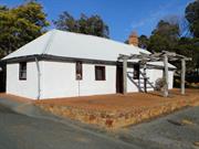
Perth Observatory is in good condition and has been well maintained. Renovations and maintenance to the place have generally been sympathetic to the original design intent.
| Library Id | Title | Medium | Year Of Publication |
|---|---|---|---|
| 6438 | Astronomy in Western Australia. | Book | 1992 |
Individual Building or Group
| Epoch | General | Specific |
|---|---|---|
| Original Use | GOVERNMENTAL | Other |
| Present Use | GOVERNMENTAL | Other |
| Style |
|---|
| Late 20th-Century International |
| Type | General | Specific |
|---|---|---|
| Wall | BRICK | Other Brick |
| General | Specific |
|---|---|
| SOCIAL & CIVIC ACTIVITIES | Institutions |
| SOCIAL & CIVIC ACTIVITIES | Education & science |
This information is provided voluntarily as a public service. The information provided is made available in good faith and is derived from sources believed to be reliable and accurate. However, the information is provided solely on the basis that readers will be responsible for making their own assessment of the matters discussed herein and are advised to verify all relevant representations, statements and information.
Constructed from 1960, Constructed from 1966
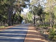
Late 20th century international style building, constructed in the late 1960s. Brick construction with metal framed windows and metal screen structure to the roof shielding the plant and machinery. Concrete steps to the front entrance, with the entrance being shielded by a flat roofed cantilevered canopy. The observatory is set within landscaped grounds with the observation domes being set in dense planting to the east of the main building.
Science and technology
Level of Integrity - High; Level of Authenticity - High
Good This complex of buildings and structures were constructed on the site from 1964 onwards. They continued and expanded the operation of the West Perth Observatory which had been operating at that site since 1897. The relocation of the observatory to one of the higher parts of the Darling Ranges enabled a larger site for expansion and diminished 'light pollution' from the Perth metropolitan area. The complex of buildings were designed by the Public Works Department of WA and construction began in 1964. The new Perth Observatory, built at a cost of $600,000 was opened by the Premier, David Brand, on Friday 30 September 1966, 70 years and one day after the original Observatory was opened by Sir John Forrest. Since 1964, the facilities have been added to and modified as technical requirements have changed and in order to provide greater access to the public.
| Name | Type | Year From | Year To |
|---|---|---|---|
| Public Works Department | Architect | 1960 | 1966 |
| Ref ID No | Ref Name | Ref Source | Ref Date |
|---|---|---|---|
| Utting M; "A History og the Perth Observatory". | |||
| ALK |
| Reserve | Lot/Location | Plan/Diagram | Vol/Folio |
|---|---|---|---|
| Lot 791 | P202177 | LR3156-116 |
| Owner | Category |
|---|---|
| WA State Government | State Gov't |
This information is provided voluntarily as a public service. The information provided is made available in good faith and is derived from sources believed to be reliable and accurate. However, the information is provided solely on the basis that readers will be responsible for making their own assessment of the matters discussed herein and are advised to verify all relevant representations, statements and information.
101 Carmel Rd Carmel
Heidelberg School
Scouts Meeting Hall
Kalamunda
Metropolitan
Constructed from 1923, Constructed from 1904
| Type | Status | Date | Documents |
|---|---|---|---|
| State Register | Registered | 05 Nov 1999 | HCWebsite.Listing+ListingDocument, HCWebsite.Listing+ListingDocument |
| Type | Status | Date | Documents |
|---|---|---|---|
| (no listings) |
| Type | Status | Date | Grading/Management | |
|---|---|---|---|---|
| Category | ||||
| Municipal Inventory | Adopted | 01 Aug 2013 | Category 1 | |
Carmel Primary School (fmr), a timber-framed, weatherboard and corrugated iron single-roomed school building (1904) and associated timber and corrugated iron shelter shed (1923) in a native bushland setting. The place is a rare example of a single roomed timber school building, located on its original site and in its original bushland setting, in the Perth metropolitan area.
| Name | Type | Year From | Year To |
|---|---|---|---|
| Public Works Department | Architect | - | - |
| Library Id | Title | Medium | Year Of Publication |
|---|---|---|---|
| 1172 | The changing face of Kalamunda : a collection of old and new photographs. Volume 2. | Book | 1987 |
Individual Building or Group
| Epoch | General | Specific |
|---|---|---|
| Original Use | EDUCATIONAL | Primary School |
| Present Use | SOCIAL\RECREATIONAL | Other |
| Type | General | Specific |
|---|---|---|
| Roof | METAL | Corrugated Iron |
| Wall | TIMBER | Weatherboard |
| General | Specific |
|---|---|
| SOCIAL & CIVIC ACTIVITIES | Education & science |
This information is provided voluntarily as a public service. The information provided is made available in good faith and is derived from sources believed to be reliable and accurate. However, the information is provided solely on the basis that readers will be responsible for making their own assessment of the matters discussed herein and are advised to verify all relevant representations, statements and information.
Constructed from 1904
The following statement is drawn from the Register Entry for the place used for its inclusion on the State Register of Heritage Places in 1999.
Very small single storey structure of timber framed construction with weatherboard cladding and a steep pitched roof clad in corrugated iron. The front elevation is dominated by three tall timber framed sash windows of 2-over-2 style. The roof is gabled in form with a lower sweep of the rear roof. The enclosed space incorporates a sash window matching the front windows whilst the rear section incorporates shallow high level windows. Further high level windows are inserted into the side (west) elevation. There are additional structures located around the site but the site is predominantly grassed with surrounding native vegetation. A flagstone pavements leads from the scout hall to Carmel Road incorporating the names and dates of the teachers of the school up to Margaret (Meg) Cooke, 1971.
Education, technology, sport and recreation, local heroes
Level of Integrity - High; Level of Authenticity - High
Good This former school building was constructed in 1904 to a standard design provided by the Public Works Department of WA. The builder, F. W. Box constructed the school building for £300. The school was built following requests to the Education Department from the local residents. In a report in the local press in 1903 it was stated that 15 to 20 children were in need of schooling in addition to 'youths' who would gladly attend night school. In 1905, the teachers quarters was built adjacent to the school room by builder M. MacKesy for £226 18s 8d. This building was again designed by the Public Works Department. During World War One the name of the school was changed to Carmel School in accordance with the policy which saw the name of the settlement Heidelberg removed from the public records. The school operated until 1990 and since that time has been used as a community resource. Currently [2013] the place is used as a scout hall.
| Ref ID No | Ref Name | Ref Source | Ref Date |
|---|---|---|---|
| "A Line on Kalamunda" | |||
| "Carmel Primary School 1904-1989". | Carmel Primary School P&C | 1989 |
| Reserve | Lot/Location | Plan/Diagram | Vol/Folio |
|---|---|---|---|
| Lot 101 | P109525 | LR3116-471 |
| Owner | Category |
|---|---|
| DOLA | State Gov't |
This information is provided voluntarily as a public service. The information provided is made available in good faith and is derived from sources believed to be reliable and accurate. However, the information is provided solely on the basis that readers will be responsible for making their own assessment of the matters discussed herein and are advised to verify all relevant representations, statements and information.
Masonmill Rd Carmel
Kalamunda
Metropolitan
Constructed from 1891
| Type | Status | Date | Documents |
|---|---|---|---|
| State Register | Registered | 07 Dec 2007 | HCWebsite.Listing+ListingDocument, HCWebsite.Listing+ListingDocument |
| Type | Status | Date | Documents |
|---|---|---|---|
| (no listings) |
| Type | Status | Date | Grading/Management | |
|---|---|---|---|---|
| Category | ||||
| Municipal Inventory | Adopted | 01 Aug 2013 | Category 1 | |
Victoria Reservoir (fmr) is in fair condition. Structurally, the concrete in the dam is of poor quality and has a history of leakage. In 1988 the Water Authority decided that the dam did not have acceptable levels of safety under modern design criteria for flood and earthquake loadings. The concrete in the dam was of such poor quality that the dam could not be adequately rehabilitated. Nevertheless the remains of the dam and its surrounding setting are well maintained.
| Library Id | Title | Medium | Year Of Publication |
|---|---|---|---|
| 7592 | Mason & Bird Heritage Trail : retracing one of Western Australia's oldest timber routes. | Brochure | 1988 |
| 9984 | Perth's early water supplies. Australian Heritage Engineering Record. | Book | 1984 |
Historic site
| Epoch | General | Specific |
|---|---|---|
| Present Use | GOVERNMENTAL | Reservoir or Dam |
| Original Use | GOVERNMENTAL | Reservoir or Dam |
| Style |
|---|
| Other Style |
| Type | General | Specific |
|---|---|---|
| Wall | CONCRETE | Other Concrete |
| General | Specific |
|---|---|
| SOCIAL & CIVIC ACTIVITIES | Community services & utilities |
| OUTSIDE INFLUENCES | Water, power, major t'port routes |
This information is provided voluntarily as a public service. The information provided is made available in good faith and is derived from sources believed to be reliable and accurate. However, the information is provided solely on the basis that readers will be responsible for making their own assessment of the matters discussed herein and are advised to verify all relevant representations, statements and information.
Constructed from 1891
The present dam was constructed in the early 1900s, just upstream from the original dam on the Darling Scarp. The new dam was the first to use roller compact concrete in its construction. Today the dam sits within National Park with walkways to the dam, around it and across the high retaining wall. The remaining section of the original dam is lower down the scarp close to the processing plant.
Water storage schemes, technology 1891 (orig. dam) 1991 (new dam)
Level of Integrity - High; Level of Authenticity - High
Good Victoria Reservoir was completed in 1891 and was Perth’s first permanent public water supply. The demand for a reliable water source became more imperative following the completion of the Zig Zag railway line to the hills in 1891. The reservoir was constructed by private contractor Edward Keane in association with Melbourne based firm Neil McNeil and Co. The fully arched gravity wall construction was built by manual labour and opened in October 1891 by a party of dignitaries led by Alexander Forrest, Mayor of Perth. Mrs Lila Keane, wife of Edward Keane, turned the valve to supply Perth with its reticulated water. Almost immediately there were problems with the quality and quantity of water from the Victoria Reservoir. Problems that were exacerbated by the increasing population in Perth as a result of the gold boom of the 1890s. The dam structure was repaired in 1912 and in 1939 the right spillway was closed off. Major renovations were undertaken in 1966 but the quality and size of the dam wall construction led to the decision in 1989 to replace the dam wall. The first water was stored in the new Victoria Dam during the 1991 winter, the system coming ‘on-line’ in November 1991. A plaque on the site records an official opening by the Minister for Water Resources, Ernie Bridge, MLA, on 22 November 1991. Also in attendance was Victoria Williams, the great-great-grand- daughter of Lila Keane, who performed the original opening ceremony in 1891. The remnants of the original wall are still in situ approximately 500 metres downstream of the new dam wall.
| Ref ID No | Ref Name | Ref Source | Ref Date |
|---|---|---|---|
| ALK, p.44; | |||
| LSC No.s: 304, 1025, 1026, 1073; | Photographs | WA Water Coproration | |
| LSC - pamphletts |
| Reserve | Lot/Location | Plan/Diagram | Vol/Folio |
|---|---|---|---|
| Lot 3071 | R47881 | Various |
| Owner | Category |
|---|---|
| Water Corporation | State Gov't |
This information is provided voluntarily as a public service. The information provided is made available in good faith and is derived from sources believed to be reliable and accurate. However, the information is provided solely on the basis that readers will be responsible for making their own assessment of the matters discussed herein and are advised to verify all relevant representations, statements and information.
20 Masonmill Rd Carmel
On the WAWA access road to the Victoria Reservoir, sth of mason's mill. GPS co-ordinates are noted as 41247E, 6455716N but no datum was supplied.
Kalamunda
Metropolitan
Constructed from 1960, Constructed from 1876
| Type | Status | Date | Documents |
|---|---|---|---|
| State Register | Registered | 09 Oct 2009 | HCWebsite.Listing+ListingDocument, HCWebsite.Listing+ListingDocument |
| Type | Status | Date | Documents |
|---|---|---|---|
| (no listings) |
| Type | Status | Date | Grading/Management | |
|---|---|---|---|---|
| Category | ||||
| Municipal Inventory | Adopted | 01 Aug 2013 | Category 1 | |
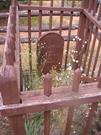
Weston Grave, Carmel is in good condition as a result of regular dedicated maintenance by the Weston family, spanning six generations. There is no evidence of termite or fire damage. At a site inspection in March 2008, one of the railings from the outer fence showed possible termite damage. However, the Weston family subsequently repaired this.
Historic site
| Epoch | General | Specific |
|---|---|---|
| Present Use | MONUMENT\CEMETERY | Grave |
| Original Use | MONUMENT\CEMETERY | Grave |
| Style |
|---|
| Other Style |
| Type | General | Specific |
|---|---|---|
| Other | TIMBER | Other Timber |
| General | Specific |
|---|---|
| DEMOGRAPHIC SETTLEMENT & MOBILITY | Workers {incl. Aboriginal, convict} |
| DEMOGRAPHIC SETTLEMENT & MOBILITY | Settlements |
This information is provided voluntarily as a public service. The information provided is made available in good faith and is derived from sources believed to be reliable and accurate. However, the information is provided solely on the basis that readers will be responsible for making their own assessment of the matters discussed herein and are advised to verify all relevant representations, statements and information.
Constructed from 1896
Well maintained gravestone and surroundings off Masonmill Road on the approach to Victoria Dam. The headstone is surrounded by timber fencing around the extent of the gravesite with the grave being further enclosed by bush timber fencing. The wider extent of the gravesite is enclosed by wire mesh fencing, enclosing native and introduced planting. A firebreak extends around the site separating it from the remainder the bushland.
Settlements, timber 19/1/1896
Level of Integrity - High; Level of Authenticity - High
Good Two day old Francis Weston died on 19th January 1876 and was buried at this site by parents Mary and Richard Weston. Richard Philip and Mary Christina Weston were the first of the Weston family to settle in this district in 1875. They lived at Carmel near Mason and Bird's Mill for two years. Richard was a wheelwright carpenter. He later became the first land holder of Pickering Brook taking up 250 acres below the present golf course, and established the "Springdale" orchard. He was a pioneer orchardist and mill owner and mill-worker in this area. Francis was the first born of eleven children, 8 of whom survived. As a carpenter, Richard Weston made the coffin, carved the headboard for the gravesite and the railings around the grave and thereafter regularly cleared around the gravesite to prevent it being destroyed by bushfire. When he moved to Pickering Brook, he rode there regularly to keep it in order and safe from fire, until he died in 1922. For the next forty years Gregory Weston, the seventh son of Richard and Mary's eleven children, also rode on horseback to maintain it. This tradition was continued by his son, Neil. Neil's two daughters Marilyn (Rollings) and Jill (Della Franca) and their children and grand-children are looking after it now [2013]. The outer railings of bush timber were installed in the 1960s by family members as a further preventative measure. The grave was included in the State Register of Heritage Places in 2009.
| Ref ID No | Ref Name | Ref Source | Ref Date |
|---|---|---|---|
| LSC No.s 289, 290, 361, 1011 | Photographs | ||
| McNamara, F; "Kalamunda of the Dreamtime", | Perth | 1961 | |
| CHF, Perth, | 1979 |
| Reserve | Lot/Location | Plan/Diagram | Vol/Folio |
|---|---|---|---|
| Lot 3071 | R47881, plan 36440 | SHO survey 10486 |
| Owner | Category |
|---|---|
| Water Corporation | State Gov't |
This information is provided voluntarily as a public service. The information provided is made available in good faith and is derived from sources believed to be reliable and accurate. However, the information is provided solely on the basis that readers will be responsible for making their own assessment of the matters discussed herein and are advised to verify all relevant representations, statements and information.
Ridge Hill Rd Gooseberry Hill
at end of 2nd loop from the bottom of the zig-zag railway
City of Perth's Quarry
Darlington Range Quarries
Kalamunda
Metropolitan
Constructed from 1894, Constructed from 1960
| Type | Status | Date | Documents |
|---|---|---|---|
| State Register | Registered | 31 Jul 2007 | HCWebsite.Listing+ListingDocument, HCWebsite.Listing+ListingDocument |
| Type | Status | Date | Documents |
|---|---|---|---|
| (no listings) |
| Type | Status | Date | Grading/Management | |
|---|---|---|---|---|
| Category | ||||
| Municipal Inventory | Adopted | 22 Mar 2013 | ||
All of the structures surviving at Statham’s Quarry (fmr), with the exception of the concrete magazine, are in a ruined but stable condition. The concrete magazine is in fair condition. The quarry face displays evidence of rock falls and is in fair condition.
| Library Id | Title | Medium | Year Of Publication |
|---|---|---|---|
| 6999 | Images CD No. 25 : Sacred Heart Church and School, Statham's Quarry, Darlington Quarry, Leithdale. | C D Rom | 2004 |
| 11823 | Statham's Quarry | 2004 | |
| 7217 | Images CD No. 25a : assessment images : Statham's Quarry; Govt. Quarries. | C D Rom | 2004 |
| 7205 | Statham's Quarry. | Report | 2004 |
Landscape
| Epoch | General | Specific |
|---|---|---|
| Present Use | PARK\RESERVE | Park\Reserve |
| Original Use | INDUSTRIAL\MANUFACTURING | Other |
| Style |
|---|
| Other Style |
| Type | General | Specific |
|---|---|---|
| Other | STONE | Granite |
| Other | CONCRETE | Other Concrete |
| Wall | BRICK | Common Brick |
| General | Specific |
|---|---|
| OCCUPATIONS | Mining {incl. mineral processing} |
| DEMOGRAPHIC SETTLEMENT & MOBILITY | Resource exploitation & depletion |
This information is provided voluntarily as a public service. The information provided is made available in good faith and is derived from sources believed to be reliable and accurate. However, the information is provided solely on the basis that readers will be responsible for making their own assessment of the matters discussed herein and are advised to verify all relevant representations, statements and information.
Statham’s Quarry (fmr), a granite and diorite quarry, comprising a quarry face, the remains of a concrete and brick crushing plant, concrete floors and tanks, the archaeological remains of the primary crushing plant, a concrete construction magazine and evidence of the spur line formation which served the quarry, has cultural heritage significance for the following reasons; · the place is a rare example of a stone quarry which has retained physical evidence of the stone crushing plant and the powder magazine; · the place has the potential to reveal archaeological information about stone crushing technology and quarry operations from the first quarter of the twentieth century; · stone from the quarry was used to pave the streets of Perth during the first quarter of the twentieth century; · the place is associated with the development of the quarrying industry in Western Australia at the end of the nineteenth century and for the first quarter of the twentieth century; and, · The quarry face forms a visually intrusive scar along the escarpment which is clearly visible from Ridge Hill Road to the west of the quarry.
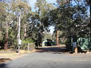
Statham’s Quarry (fmr) consists of a single quarry face, the remains of a stone crushing plant, water tanks, a concrete magazine and several concrete foundations and floors. The site forms part of the Darling Range Regional Park and is bounded on the southern side by the Zig Zag Scenic Drive, which was once the Canning Jarrah Timber Company’s railway line. Native trees and plants are gradually regenerating in the Regional Park. The quarry’s old spur line, which once ran into the northern side of the Canning Jarrah Timber Company’s railway line, now forms one of the walking trails in the park. The ruins of the main crushing building are located on the western edge of the quarry floor, while there are additional features to the south and north of this structure. A shallow depression to the east of the former crusher, together with a dirt ramp, was probably associated with the primary crushing plant. Evidence of the tram route which brought the trucks to this crusher have been retained. The formation for the spur line which served the quarry is located on the western side of the main crusher and runs approximately north-south. The high quarry face forms a rough semi-circle around the large floor which has a dirt track running around the perimeter. The quarry face shows evidence of past quarrying activity and loose rock and rock debris at the base of the face indicates that there is some instability. Two modern structures have also been built on the quarry floor. On the south-eastern side of the hill is a modern earth latrine constructed from zincalume. On the northern side of the oval depression is a modern shelter shed constructed from poles, open-sided with a hipped zincalume roof and timber picnic table and benches. The remains of the main crushing plant are located to the north-west of the small hill and the concrete floor. The former crushing plant is surrounded by a cyclone mesh fence which is kept locked. Sections of the building have collapsed or are missing. All the structures on the site, with the exception of the two modern buildings, are in a ruined condition. The quarry face displays evidence of past rock slippage down the face but is still in an intact condition.
This quarry was established in 1894 by Thomas Statham (1858-1918). Thomas Statham, arrived in Western Australia from England in the late 1880s and began a number of commercial enterprises. These included quarries in the Perth hills, a gravel pit, brickworks and an interest in timber milling in Glen Forest. From 1899 he was managing director of Darling Range Quarry, Fire Brick and Gravel Company, which dissolved within a year. Statham was on the Darling Range Roads Board from 1899 to 1902 and subsequently a Perth City Councillor in 1903. From 1907, Statham also had an interest in pastoral properties in the Gascoyne. The quarry provided blue stone for road construction and was in high demand in the 1890s when Perth was expanding due to the gold discoveries in the east of the colony. Statham's Quarry, or Darling Range Quarries and Firebrick Company was one of a number of similar companies awarded contracts with the Perth City Council. The material from the quarry was transported to Perth via the nearby Zig Zag railway. Following the death of Statham in 1918 the property was ultimately purchased by the City of Perth in 1920. The City of Perth upgraded the machinery at the quarry at a considerable cost and the municipal quarry was opened on 9 January 1924 by Governor Sir Francis Newdegate. The quarry operated successfully until the onset of the Depression and then operated only intermittently. The onset of World War II meant that the quarry was not worked from 1939 due to the lack of labour and the provision of material more cheaply from other suppliers. The quarry was extensively damaged in a fire in 1957 and the cost of re-opening the quarry even during this period of economic prosperity was too expensive to be justified. The quarry was transferred to the Metropolitan Regional Planning Authority in 1971 and is currently managed by the Department of Environment and Conservation as an area for public recreation.
Level of Integrity - High; Level of Authenticity - High
Fair This quarry was established in 1894 by Thomas Statham (1858-1918). Thomas Statham, arrived in Western Australia from England in the late 1880s and began a number of commercial enterprises. These included quarries in the Perth hills, a gravel pit, brickworks and an interest in timber milling in Glen Forest. From 1899 he was managing director of Darling Range Quarry, Fire Brick and Gravel Company, which dissolved within a year. Statham was on the Darling Range Roads Board from 1899 to 1902 and subsequently a Perth City Councillor in 1903. From 1907, Statham also had an interest in pastoral properties in the Gascoyne. The quarry provided blue stone for road construction and was in high demand in the 1890s when Perth was expanding due to the gold discoveries in the east of the colony. Statham's Quarry, or Darling Range Quarries and Firebrick Company was one of a number of similar companies awarded contracts with the Perth City Council. The material from the quarry was transported to Perth via the nearby Zig Zag railway. Following the death of Statham in 1918 the property was ultimately purchased by the City of Perth in 1920. The City of Perth upgraded the machinery at the quarry at a considerable cost and the municipal quarry was opened on 9 January 1924 by Governor Sir Francis Newdegate. The quarry operated successfully until the onset of the Depression and then operated only intermittently. The onset of World War II meant that the quarry was not worked from 1939 due to the lack of labour and the provision of material more cheaply from other suppliers. The quarry was extensively damaged in a fire in 1957 and the cost of re-opening the quarry even during this period of economic prosperity was too expensive to be justified. The quarry was transferred to the Metropolitan Regional Planning Authority in 1971 and is currently managed by the Department of Environment and Conservation as an area for public recreation.
| Reserve | Lot/Location | Plan/Diagram | Vol/Folio |
|---|---|---|---|
| Lot 3040 on | DP36439;R47880 | C/T 3134/988 |
This information is provided voluntarily as a public service. The information provided is made available in good faith and is derived from sources believed to be reliable and accurate. However, the information is provided solely on the basis that readers will be responsible for making their own assessment of the matters discussed herein and are advised to verify all relevant representations, statements and information.
120 Heath Rd Kalamunda
Previously listed as 37 Panoramic Tce, Kalamunda
Asphodel
House and former Floriculture Nursery
Kalamunda
Metropolitan
Constructed from 1935, Constructed from 1982
| Type | Status | Date | Documents |
|---|---|---|---|
| State Register | Registered | 11 Aug 2009 | HCWebsite.Listing+ListingDocument, HCWebsite.Listing+ListingDocument |
| Type | Status | Date | Documents |
|---|---|---|---|
| (no listings) |
| Type | Status | Date | Grading/Management | |
|---|---|---|---|---|
| Category | ||||
| Municipal Inventory | Adopted | 01 Aug 2013 | ||
Fair to good condition
| Library Id | Title | Medium | Year Of Publication |
|---|---|---|---|
| 5682 | House and former Floriculture Nursery, 120 Heath Road, Kalamunda : archival record. | Report | 2002 |
Individual Building or Group
| Epoch | General | Specific |
|---|---|---|
| Present Use | RESIDENTIAL | Single storey residence |
| Original Use | COMMERCIAL | Other |
| Original Use | RESIDENTIAL | Single storey residence |
| Type | General | Specific |
|---|---|---|
| Wall | TIMBER | Other Timber |
| Roof | METAL | Corrugated Iron |
| General | Specific |
|---|---|
| OCCUPATIONS | Rural industry & market gardening |
| DEMOGRAPHIC SETTLEMENT & MOBILITY | Land allocation & subdivision |
This information is provided voluntarily as a public service. The information provided is made available in good faith and is derived from sources believed to be reliable and accurate. However, the information is provided solely on the basis that readers will be responsible for making their own assessment of the matters discussed herein and are advised to verify all relevant representations, statements and information.
The following statement is drawn from the register entry for the inclusion of the place in the State Register of Heritage Places in 2009.
Remnant plantings in the national park amongst native plantings. Remains of former built elements were not found.
In 1933, when Arthur Ferdinand Walters purchased Location 1394 he had more in mind than a holiday destination. Walters, a schoolteacher, and principal of the Princess May School in Fremantle, had a long held interest in floriculture, which he was keen to develop further. To this end he built a dwelling on Location 1394, a basic, 'weekender', where Arthur and Edith Walters, and their family, used during weekend visits while establishing an orchard and floriculture nursery. Walters named the property ‘Asphodel’, an aesthetic reference associated with the yellow and white flowering plants of the Asphodelus and Asphodeline genera, which includes daffodils, which he grew in abundance in the Floriculture Nursery As well as daffodils, the floriculture nursery included arum lilies grown in Crumpet Creek on the valley floor, a series of ponds for the cultivation of water lilies, a shade house for hydrangeas, a rockery, a dozen camellias which supplied white flowers for Karrakatta cemetery, Dutch iris, and roses. The orchard included apple, plum and quince trees, and there were blackberry and mulberry bushes. A dam for irrigation was established on the rise of the hill to supply irrigation water by gravity feed. The dam also supplied water for the house. Fresh flowers from the nursery were supplied to florists in Fremantle and Perth. Arthur Walters did not advertise his floriculture nursery widely to the general public, nor did he sell plants or seeds, or floral arrangements. He was actually a wholesaler to retail florists. As such, he appears to have been in a minority in this area of specialisation, certainly in the early years. Arthur Walters transferred the property to his daughter and son-in law in 1952 and they continued the business until 1960 and sold the property. The nursery continued for six or seven years then declined as ownership changed. In 1978, the remaining portion of Location 1394 was purchased by the State Government's Metropolitan Region Planning Authority (now Western Australian Planning Commission) as part of a green belt. The house remained on the site and was restored in 1982 but was demolished in 2002 as part of CALM policy when taking on the management of the land.
Level of Integrity - Low; Level of Authenticity - Low
N/A In 1933, when Arthur Ferdinand Walters purchased Location 1394 he had more in mind than a holiday destination. Walters, a schoolteacher, and principal of the Princess May School in Fremantle, had a long held interest in floriculture, which he was keen to develop further. To this end he built a dwelling on Location 1394, a basic, 'weekender', where Arthur and Edith Walters, and their family, used during weekend visits while establishing an orchard and floriculture nursery. Walters named the property ‘Asphodel’, an aesthetic reference associated with the yellow and white flowering plants of the Asphodelus and Asphodeline genera, which includes daffodils, which he grew in abundance in the Floriculture Nursery As well as daffodils, the floriculture nursery included arum lilies grown in Crumpet Creek on the valley floor, a series of ponds for the cultivation of water lilies, a shade house for hydrangeas, a rockery, a dozen camellias which supplied white flowers for Karrakatta cemetery, Dutch iris, and roses. The orchard included apple, plum and quince trees, and there were blackberry and mulberry bushes. A dam for irrigation was established on the rise of the hill to supply irrigation water by gravity feed. The dam also supplied water for the house. Fresh flowers from the nursery were supplied to florists in Fremantle and Perth. Arthur Walters did not advertise his floriculture nursery widely to the general public, nor did he sell plants or seeds, or floral arrangements. He was actually a wholesaler to retail florists. As such, he appears to have been in a minority in this area of specialisation, certainly in the early years. Arthur Walters transferred the property to his daughter and son-in law in 1952 and they continued the business until 1960 and sold the property. The nursery continued for six or seven years then declined as ownership changed. In 1978, the remaining portion of Location 1394 was purchased by the State Government's Metropolitan Region Planning Authority (now Western Australian Planning Commission) as part of a green belt. The house remained on the site and was restored in 1982 but was demolished in 2002 as part of CALM policy when taking on the management of the land.
| Reserve | Lot/Location | Plan/Diagram | Vol/Folio |
|---|---|---|---|
| Lot 1394 | DP 249022 | 1956/11 |
This information is provided voluntarily as a public service. The information provided is made available in good faith and is derived from sources believed to be reliable and accurate. However, the information is provided solely on the basis that readers will be responsible for making their own assessment of the matters discussed herein and are advised to verify all relevant representations, statements and information.
18 Kalamunda Rd Kalamunda
Kalamunda
Metropolitan
Constructed from 1881
| Type | Status | Date | Documents |
|---|---|---|---|
| State Register | Registered | 18 Mar 2005 | HCWebsite.Listing+ListingDocument, HCWebsite.Listing+ListingDocument |
| Type | Status | Date | Documents |
|---|---|---|---|
| (no listings) |
| Type | Status | Date | Grading/Management | |
|---|---|---|---|---|
| Category | ||||
| Municipal Inventory | Adopted | 01 Aug 2013 | Category 1 | |
| Register of the National Estate | Permanent | 21 Mar 1978 | ||
| Classified by the National Trust | Classified | 07 Dec 1970 | ||
Stirk Cottage is in good condition relative to its age and has generally been well maintained. The corrugated iron roof has provided valuable protection for the sheoak and jarrah roof shingles underneath, and provided further protection for the interior. Repairs have been carried out to the rotting timbers at ground level in the walls, and termite damaged roof timbers and shingles have been replaced (1983-84). Borer damage to the original timber framing, evident on the western corners of the building, appears to have been halted. Considerable excavation has also been carried out at the front of the building to prevent surface water running under the cottage. This appears to be the reason for the construction of the raised brick entry platform. The downpipes are leaking and are in need of repair to prevent water damage to the building fabric. Similarly, the leadlight window on the south elevation is broken and boarded over, and should be repaired.
| Name | Type | Year From | Year To |
|---|---|---|---|
| Stirk, Frederick | Architect | - | - |
| Library Id | Title | Medium | Year Of Publication |
|---|---|---|---|
| 7727 | Stirk cottage: draft conservation plan, Kalamunda Perth, March 2006. | Heritage Study {Cons'n Plan} | 2005 |
| 6604 | The changing face of Kalamunda : a collection of old and new photographs. Volume 1. | Book | 1982 |
| 1172 | The changing face of Kalamunda : a collection of old and new photographs. Volume 2. | Book | 1987 |
Individual Building or Group
| Epoch | General | Specific |
|---|---|---|
| Original Use | FARMING\PASTORAL | Cottage |
| Present Use | EDUCATIONAL | Museum |
| Style |
|---|
| Victorian Georgian |
| Type | General | Specific |
|---|---|---|
| Wall | EARTH | Wattle and Daub |
| Roof | TIMBER | Shingle |
| Wall | EARTH | Adobe {Mud Brick} |
| General | Specific |
|---|---|
| DEMOGRAPHIC SETTLEMENT & MOBILITY | Settlements |
| PEOPLE | Early settlers |
| OCCUPATIONS | Rural industry & market gardening |
This information is provided voluntarily as a public service. The information provided is made available in good faith and is derived from sources believed to be reliable and accurate. However, the information is provided solely on the basis that readers will be responsible for making their own assessment of the matters discussed herein and are advised to verify all relevant representations, statements and information.
Constructed from 1881
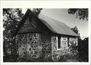
Single storey cottage of simple rectangular plan form. The property is constructed utilising traditional construction methods of wattle and daub painted externally with a white lime wash. Hipped roof form clad with corrugated galvanised iron with clay brick chimney. Timber framed windows of various shapes and styles. Ledge and braced front entrance door. There is no verandah but the cottage does incorporate a raised paved area to the front with a bush timber pergola in front of the entrance door.
Early settlers, land allocation, orchards/market gardens, local heroes
Level of Integrity - High; Level of Authenticity - High
Good Frederick Stirk , his wife Elizabeth, and their young daughter, Mary Hannah, left their Yorkshire home in 1875 to emigrate to Western Australia. Frederick found work in Guildford in the timber industry and regularly travelled into the Darling Range. He was impressed with the land and c1880 acquired 15 acres in what was known as 'Second Gully' and he named 'Headingly Hill'. He and Elizabeth cleared the land and established a farm, first living in a tent then in 1881 building a simple two roomed wattle and daub cottage roofed with shingles. The cottage was added to with another wattle and daub room and later a room made from sun dried mud bricks made on the property. The Stirks had a large family of nine children all of whom worked on the farm. By the 1890s the district had begun to be more established with the completion of the railway line to Kalamunda. The Stirk family moved to another cottage nearby and the original cottage was leased to Charles Brooks the owner of the first store in the settlement. He occupied the cottage until 1903 and after that it was leased to a variety of tenants. In 1933, following Frederick Stirk's death, the property was purchased by Francis Roberts who operated a dairy from the site and leased the cottage to different tenants. His descendants sold the cottage and surrounding land to the Darling Range Roads Board in 1949 for recreational purposes. Despite some initial thoughts from the Road Board that the cottage should be demolished community pressure led to its subsequent renovation by local volunteers. The cottage maintenance and conservation has since been managed by the Kalamunda and Districts Historical Society and it was opened in 1969 as a museum. A subsequent program of conservation works was completed in 1984.
| Ref ID No | Ref Name | Ref Source | Ref Date |
|---|---|---|---|
| ALK, p. 14; | |||
| CHF, pp. 64-67,168,196-7; | |||
| CFK, pp. 1 & 2, Vol.2, p.28; | |||
| "Pioneering - Mrs Stirk's Memoirs" | Western Mail, | Oct 8, 1931. |
| Reserve | Lot/Location | Plan/Diagram | Vol/Folio |
|---|---|---|---|
| Lot 101 | P248350 | 1034-773 |
| Owner | Category |
|---|---|
| Kalamunda Shire Council | Local Gov't |
This information is provided voluntarily as a public service. The information provided is made available in good faith and is derived from sources believed to be reliable and accurate. However, the information is provided solely on the basis that readers will be responsible for making their own assessment of the matters discussed herein and are advised to verify all relevant representations, statements and information.
43 Railway Rd Kalamunda
Kalamunda
Metropolitan
| Type | Status | Date | Documents |
|---|---|---|---|
| (no listings) |
| Type | Status | Date | Documents |
|---|---|---|---|
| (no listings) |
| Type | Status | Date | Grading/Management | |
|---|---|---|---|---|
| Category | ||||
| Municipal Inventory | Adopted | 01 Aug 2013 | Category 1 | |
01251 Kalamunda Hotel and Original Kalamunda Hotel
Individual Building or Group
| Epoch | General | Specific |
|---|---|---|
| Present Use | COMMERCIAL | Hotel, Tavern or Inn |
| Original Use | COMMERCIAL | Hotel, Tavern or Inn |
| Style |
|---|
| Federation Filigree |
| Type | General | Specific |
|---|---|---|
| Roof | TILE | Ceramic Tile |
| Wall | BRICK | Common Brick |
| General | Specific |
|---|---|
| SOCIAL & CIVIC ACTIVITIES | Sport, recreation & entertainment |
This information is provided voluntarily as a public service. The information provided is made available in good faith and is derived from sources believed to be reliable and accurate. However, the information is provided solely on the basis that readers will be responsible for making their own assessment of the matters discussed herein and are advised to verify all relevant representations, statements and information.
Constructed from 1927
The following statement is drawn from the Register entry for the inclusion of the place on testate Register of Heritage Places in 2005.
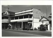
A dominant two storey brick and tiled building that extends along two roads, Railway Road and Central Road creating a ‘v’ shape to the building. The Railway Road façade is the principal elevation incorporating two gables and a central arched parapet with ‘Kalamunda Hotel’ embellished across the front. The brick work has been painted to the front with glazed bricks to the lower section of the façade. A substantial verandah extends across the full extent of the façade. The upper level section of the verandah is supported on timber columns set in concrete bases with timber deck and balustrade. There is a regular rhythm of timber sash windows and timber and glazed doors to the upper balcony, obscured by balcony blinds. The side elevations are face brickwork with concrete sills and elaborate bracketed concrete window hoods. The hotel has been altered over time but still presents as it was intended. A beer garden has been constructed to the front of the hotel, below pavement level and enclosed by metal railings.
Technology, hospitality, sport and recreation, local heroes
Level of Integrity - High; Level of Authenticity - Moderate
Good In 1901, the town of Kalamunda was laid out with the road parallel to the rail line (Railway Road) designated as the main town street. Lots 20, 21 and 22 on Railway Road were purchased by a Midland publican, Harry Hummerston, who immediately set about the construction of what was the second brick building in the area - the first being the Agricultural Hall - to be operated as a hotel. By February 1902, an application for a Provisional Certificate for the hotel was granted to Richard E. Hummerston. On 25 June 1902, the Hotel was opened, having been completed for a cost of £2,000. This in now known as the Old Kalamunda Hotel. Not long after the Kalamunda Hotel opened, the surrounding area became increasingly popular as a resort town and continued into the 1920s when motor transport became more important. Sometime in the late 1920s, the Kalamunda Hotel was purchased by Patrick Andrew (‘Paddy’) Connolly who, in 1927-1928, built a new hotel alongside the original 1902 hotel building. This new hotel was designed by architect, George Herbert Parry. The building presented a strong elevation to the street, with the common feature of a pavement verandah with first floor balcony above. Built of brick and tile with plaster finish to the first floor balcony and roof gables, the only other decorative treatment to the exterior was the use of glazed ceramic tiles to the front wall of the ground floor. After the new Hotel’s opening in the first half of 1928 the combined buildings could accommodate 50 guests. The new Hotel also provided a spacious Lounge, Drawing, Dining, and Billiard Rooms. The local press were enthusiastic about the facilities. Kalamunda has now a hotel commensurate with the importance of the district … Construction of the hotel cost 30,000 pounds, it was well-designed and fitted with every modern convenience … Soft carpet runners ensure quietness and beautiful lighting effects are secured at stair heads and lobbies by the provision of stained glass skylights and shaded globes. The bed rooms are luxuriously fitted out. Porcelain basins are in every room, with hot and cold water … The double rooms will be eagerly sought by honeymoon couples, on account of their beautiful appearance. The dining room is spacious and well lighted, and the tables sparkle with silver and glass and are daintily arranged. Bath rooms and lavatories are spotlessly clean, and the white tile work gives a bright appearance. The lounge provides cosy comfort, while the activities in the street may be viewed from a wide balcony. The bar, of course, has every modern convenience. Kalamunda maintained its popularity as a tourist resort throughout the 1930s and early 1940s but declined thereafter. By 1948, most of Kalamunda’s hostels and boarding houses had closed down as motor travel and improved roads enabled other areas of Western Australia to compete with the established holiday destinations. Connolly was Western Australia’s most successful racehorse owner, with a record unlikely to be bettered. However as he aged, Connolly became increasingly reclusive and eccentric and on his death in 1948 his fortune passed largely to charities. The hotel remained unchanged until the 1970s. In the 1970s the property changed hands and proposals to demolish the buildings met with local opposition. Subsequent owners have undertaken alterations and additions that have integrated the two buildings and maintained the majority of the original built fabric. The hotel, consisting of the 1902 and 1928 buildings, was included on the State Register of Heritage Places on a permanent basis in 2005.
| Name | Type | Year From | Year To |
|---|---|---|---|
| Herbert Parry | Architect | 1927 | - |
| Ref ID No | Ref Name | Ref Source | Ref Date |
|---|---|---|---|
| W/B 27,28,116,117,118 | Photographs | ||
| 'Cala-Munda A Home in the Forest". CFK Vols 1&2, pp. 96, 211 | |||
| LSC No.s 723, 724, | Photographs | ||
| LSC No.s 1166, 1402, 1865, 1905 | Photographs |
| Reserve | Lot/Location | Plan/Diagram | Vol/Folio |
|---|---|---|---|
| Lot 41 | D76157 | 1910-853 |
| Owner | Category |
|---|---|
| Samosa Pty Ltd | Other Private |
This information is provided voluntarily as a public service. The information provided is made available in good faith and is derived from sources believed to be reliable and accurate. However, the information is provided solely on the basis that readers will be responsible for making their own assessment of the matters discussed herein and are advised to verify all relevant representations, statements and information.
43 Railway Rd Kalamunda
Kalamunda
Metropolitan
| Type | Status | Date | Documents |
|---|---|---|---|
| (no listings) |
| Type | Status | Date | Documents |
|---|---|---|---|
| (no listings) |
| Type | Status | Date | Grading/Management | |
|---|---|---|---|---|
| Category | ||||
| Municipal Inventory | Adopted | 01 Aug 2013 | Category 1 | |
01251 Kalamunda Hotel and Original Kalamunda Hotel
Individual Building or Group
| Epoch | General | Specific |
|---|---|---|
| Original Use | COMMERCIAL | Hotel, Tavern or Inn |
| Present Use | COMMERCIAL | Shop\Retail Store {single} |
| Style |
|---|
| Federation Filigree |
| Type | General | Specific |
|---|---|---|
| Wall | BRICK | Common Brick |
| Roof | METAL | Corrugated Iron |
| General | Specific |
|---|---|
| SOCIAL & CIVIC ACTIVITIES | Sport, recreation & entertainment |
This information is provided voluntarily as a public service. The information provided is made available in good faith and is derived from sources believed to be reliable and accurate. However, the information is provided solely on the basis that readers will be responsible for making their own assessment of the matters discussed herein and are advised to verify all relevant representations, statements and information.
Constructed from 1902, Constructed from 1988
The following statement is drawn from the Register entry for the inclusion of the place on the State Register of Heritage Places in 2005.
The original hotel is a two storey brick structure of federation filigree style incorporating concrete detailing and brick parapet with concrete coping. A verandah/balcony extends across the front elevation with timber columns and bracketed supports with a simple timber balustrade to the upper level. The canopy is of red colorbond in a skillion style. The main roof to the hotel is hidden behind the brick parapets but is of single pitch, sloping away from the front of the building and is clad with grey colorbond. The front elevation is punctuated by sash windows to both levels and is enhanced by the chamfered corner at the southern end of the façade, which originally incorporated an entrance into the hotel/bar, the brick arch around the original opening with feature keystone and hood moulding remains extant. At the northern end of the façade a shop frontage has been introduced with a chequerboard fascia above the window. The main entrance to the hotel is between the two rendered pilasters on the Railway Road façade. Although altered much of the original detailing has been retained enabling the building to still be read as it was originally designed.
Technology, hospitality, sport and recreation
Level of Integrity - Moderate; Level of Authenticity - Moderate
Good In 1901, the town of Kalamunda was laid out with the road parallel to the rail line (Railway Road) designated as the main town street. Lots 20, 21 and 22 on Railway Road were purchased by a Midland publican, Harry Hummerston, who immediately set about the construction of what was the second brick building in the area - the first being the Agricultural Hall - to be operated as a hotel. The bricks used in the construction of the hotel were made on the Stirk property, less than a quarter of a mile away. A joiner made all the fittings, such as doors, windows and counters, on site. By February 1902, an application for a Provisional Certificate for the hotel was granted to Richard E. Hummerston. On 25 June 1902, the Hotel was opened, having been completed for a cost of £2,000. There is no record of who designed or built the premises. Not long after the Kalamunda Hotel opened, the surrounding area became increasingly popular as a resort town and continued into the 1920s when motor transport became more important. Sometime in the late 1920s, the Kalamunda Hotel was purchased by Patrick Andrew (‘Paddy’) Connolly who, in 1927-1928, built a new hotel alongside the original 1902 hotel building. After the new Hotel’s opening in the first half of 1928 the combined buildings could accommodate 50 guests. The new Hotel also provided a spacious Lounge, Drawing, Dining, and Billiard Rooms. With the transference of the Liquor License to the new Hotel in 1927, the ground floor of the 1902 building was turned into shops and used for various office and commercial purposes. One of these housed the town’s first bank (the E.S.&A. Bank), others, the booking office for the local taxi company, and the local newspaper. Kalamunda maintained its popularity as a tourist resort throughout the 1930s and early 1940s but declined thereafter. By 1948, most of Kalamunda’s hostels and boarding houses had closed down as motor travel and improved roads enabled other areas of Western Australia to compete with the established holiday destinations. Connolly was Western Australia’s most successful racehorse owner, with a record unlikely to be bettered. However as he aged, Connolly became increasingly reclusive and eccentric and on his death in 1948 his fortune passed largely to charities. Both buildings remained unchanged until the 1970s. In the 1970s the property changed hands and proposals to demolish the buildings met with local opposition. Subsequent owners have undertaken alterations and additions that have integrated the two buildings and maintained the majority of the original built fabric. The hotel, consisting of the 1902 and 1928 buildings, was included on the State Register of Heritage Places on a permanent basis in 2005.
| Ref ID No | Ref Name | Ref Source | Ref Date |
|---|---|---|---|
| Neg. No. W/B10). | Photographs | Local Studies Collection | 1903 |
| "Cala-Munda A Home in the Forest". | |||
| CFK Vol.1 & CFK Vol.2 | |||
| No.s 218, 660, 724, 1055, 1867 | Photographs | Local Studies Collection | |
| "Changing Face of Kalamunda - Vols 1 & 2", |
| Reserve | Lot/Location | Plan/Diagram | Vol/Folio |
|---|---|---|---|
| Lot 41 | D76157 | 1910-853 |
| Owner | Category |
|---|---|
| Samosa Pty Ltd | Other Private |
This information is provided voluntarily as a public service. The information provided is made available in good faith and is derived from sources believed to be reliable and accurate. However, the information is provided solely on the basis that readers will be responsible for making their own assessment of the matters discussed herein and are advised to verify all relevant representations, statements and information.
43-45 Railway Rd Kalamunda
Kalamunda
Metropolitan
Constructed from 1927, Constructed from 1902
| Type | Status | Date | Documents |
|---|---|---|---|
| State Register | Registered | 24 Mar 2005 | HCWebsite.Listing+ListingDocument, HCWebsite.Listing+ListingDocument |
| Type | Status | Date | Documents |
|---|---|---|---|
| (no listings) |
| Type | Status | Date | Grading/Management | |
|---|---|---|---|---|
| Category | ||||
| Classified by the National Trust | Classified | 09 Apr 1996 | ||
| Fire & Rescue Service Heritage Inventory | Adopted | 01 Nov 1997 | ||
The Kalamunda Hotel has been well maintained because of its continued use as a hotel and public bar and is in very good condition. The Original Kalamunda Hotel is in fair-good condition. Some of the interior finishes and the timber floors show considerable wear. The first floor rooms of the Original Kalamunda Hotel are understood to be quite dilapidated. The external fabric of the building is in good condition.
| Name | Type | Year From | Year To |
|---|---|---|---|
| George Herbert Parry | Architect | - | - |
| Library Id | Title | Medium | Year Of Publication |
|---|---|---|---|
| 8527 | Conservation plan for Kalamunda Hotel and original Kalamunda Hotel, 43 Railway Road, Kalamunda, WA. | Heritage Study {Cons'n Plan} | 2007 |
| 6604 | The changing face of Kalamunda : a collection of old and new photographs. Volume 1. | Book | 1982 |
| 1172 | The changing face of Kalamunda : a collection of old and new photographs. Volume 2. | Book | 1987 |
| 8886 | Conservation works to front verandah : Kalamunda Hotel. Final progress report. | Conservation works report | 2007 |
| 9267 | Conservation external works: roof, gutters and concrete hoods. Kalamunda Hotel. | Conservation works report | 2008 |
Individual Building or Group
| Epoch | General | Specific |
|---|---|---|
| Original Use | COMMERCIAL | Hotel, Tavern or Inn |
| Present Use | COMMERCIAL | Hotel, Tavern or Inn |
| Style |
|---|
| Federation Filigree |
| Type | General | Specific |
|---|---|---|
| Wall | BRICK | Common Brick |
| Wall | BRICK | Other Brick |
| Roof | TILE | Other Tile |
| Roof | METAL | Corrugated Iron |
| General | Specific |
|---|---|
| SOCIAL & CIVIC ACTIVITIES | Sport, recreation & entertainment |
| OCCUPATIONS | Hospitality industry & tourism |
This information is provided voluntarily as a public service. The information provided is made available in good faith and is derived from sources believed to be reliable and accurate. However, the information is provided solely on the basis that readers will be responsible for making their own assessment of the matters discussed herein and are advised to verify all relevant representations, statements and information.
12 Catherine Pl Lesmurdie
Registered as part of P16819 Lesmurdie Group
Kalamunda
Metropolitan
Constructed from 1910, Constructed from 1956
| Type | Status | Date | Documents |
|---|---|---|---|
| (no listings) |
| Type | Status | Date | Documents |
|---|---|---|---|
| (no listings) |
| Type | Status | Date | Grading/Management | |
|---|---|---|---|---|
| Category | ||||
| Municipal Inventory | Adopted | 01 Aug 2013 | Category 1 | |
16819 Lesmurdie Group
Lesmurdie House & Estate is in good condition and has generally been well maintained. Parts of the interior fabric of the residence show signs of water damage, particularly the floor of the former Dining Room and ceiling of the enclosed front verandah. The former orchard store is in fair condition and shows considerable signs of wear. The verandah and roof need maintenance to stabilize their condition. Internally, the original fabric is in fair condition, with the floors and walls showing signs of deterioration caused by age and wear. The grounds of Lesmurdie House & Estate are in good condition and are well maintained. The brick and timber fence that edges the gravel terrace is in fair condition, although a number of fence palings are missing. The gardens, lawns and trees are well maintained. The concrete garden bathing-pool and Lesmurdie Brook are in good condition, although ducks currently inhabit the pool.
| Name | Type | Year From | Year To |
|---|---|---|---|
| George Herbert Parry | Architect | 1909 | 1913 |
Individual Building or Group
| Epoch | General | Specific |
|---|---|---|
| Original Use | RESIDENTIAL | Single storey residence |
| Other Use | HEALTH | Hospital |
| Present Use | EDUCATIONAL | Housing or Quarters |
| Present Use | RESIDENTIAL | Two storey residence |
| Style |
|---|
| Federation Queen Anne |
| Victorian Georgian |
| Type | General | Specific |
|---|---|---|
| Wall | BRICK | Common Brick |
| Wall | STONE | Local Stone |
| Roof | TILE | Terracotta Tile |
| General | Specific |
|---|---|
| OCCUPATIONS | Hospitality industry & tourism |
| DEMOGRAPHIC SETTLEMENT & MOBILITY | Land allocation & subdivision |
| OCCUPATIONS | Domestic activities |
This information is provided voluntarily as a public service. The information provided is made available in good faith and is derived from sources believed to be reliable and accurate. However, the information is provided solely on the basis that readers will be responsible for making their own assessment of the matters discussed herein and are advised to verify all relevant representations, statements and information.
Constructed from 1909, Constructed from 1898
Lesmurdie House a two-storey stone and brick residence in the Federation Queen Anne style, constructed on the site of and as extensions to an 1898 two-room cottage (demolished 1910), with an orchard store and a garden bathing-pool set in expansive landscaped grounds has cultural heritage significance for the following reasons; · Lesmurdie House & Estate is a good representative example of a Federation Queen Anne style residence, developed as a private retreat in the hills district east of Perth, · The group, through its associations with the influential early Sanderson family, and provision of educational, health and religious services, is closely linked to the development of the Kalamunda district in the 20th century, and particularly the locality of Lesmurdie, which derives its name from Lesmurdie House & Estate, · Lesmurdie House includes a good example of Federation garden style landscaping, which combines with the nearby native forest to produce pleasing environs; · Lesmurdie House was chosen by Government officials to accommodate the Duke and Duchess of York for a weekend retreat during their Australian tour in 1927, which generated publicity to boost the growing hills tourism industry in the Interwar years.
Lesmurdie House is a Queen Anne style residence that has been enlarged but retained much of its original design ethos. The original section of the house is of single storey construction, built from laterite stone with red brick quoining with a hipped roof clad with Marseilles tiles. The original section occupies the eastern section of the house and is characterised by a distinctive brick bay in what would have been the centre of the original north façade, with rendered and timbered gable detail. Each of the three sides of the bay element contains windows, single openings to the side and a larger opening in the front face. All have timber shutters painted dark green. There is a further small window in the return of the bay, again with shutters. The east elevation demonstrates a more functional side of the house with the main entrance door under a flat suspended door canopy and a secondary doorway in the same elevation accessed by a short flight of stairs at the north-east corner. The central section is dominated by a covered verandah area with the iron canopy being supported on brick columns. Small paned French doors lead onto the verandah. There is no enclosure to the verandah but the base is constructed on laterite stone retaining which demonstrates the slight variance in topography at this side of the building. To the south of the verandah the former ‘porte cochere’ has been converted to provide additional accommodation. The form of the element remains intact but the open sides have been in filled with weatherboards. The original timber valance has been retained adding an element of interest to the structure. All windows are multi-paned openings. The eaves are wide overhanging boxed eaves with a distinctive moulding pattern to the lining. This pattern and form of eaves extends around the building. To the west of the original section, an interconnecting element of weatherboard and rendered construction links the sections of the house. This section is two storeys with a small gabled dormer to the upper level and a small area of brick walling containing a small multi-paned window to the lower level, to the west of the doorway. Adjacent is a further section of the former house which resembles the construction method of the original part. Laterite stone with red brick quoining to the corners and openings, tall brick and rendered chimneys.
Early settlers, local heroes, land allocation, technology, hospitality, community services Private hostel (1934), rented (1937), flats (post WW2), private hospital (1960-74)
Level of Integrity - Lesmurdie House - Moderate Heritage Building - High; Level of Authenticity - Lesmurdie House - Moderate Heritage Building - Moderate
Good Archibald Sanderson was born at Glen Thompson, Victoria, in 1870, the fourth son of John Sanderson, who had founded (in 1858) the Melbourne firm of John Sanderson and Co, an agency of Sanderson and Murray, wool merchants of Galashiels, Scotland. In 1871, the family returned to England where John Sanderson became a partner in Sanderson and Murray’s London Branch in 1876. Archibald Sanderson was educated at Haileybury College in England, and later attended Oxford University. From 1892 until 1894, he worked as a journalist in New Zealand. In 1894, Sanderson came to Western Australia and cycled through the Coolgardie goldfields in the capacity of special correspondent of the Christchurch Press and the New Zealand Times. In Coolgardie, he had a short involvement with the mining industry but later in 1895, moved to Perth. There, Sanderson found work as assistant master of the Perth High School for a few months until joining the Perth Morning Herald as leader-writer and assistant-editor. While at the Perth High School Sanderson met E.W. ‘Paddy’ Haynes, who, in 1895, brought him to visit the Darling Range. Sanderson liked the country and, in 1897, bought (Lot 227) for £20. Sanderson worked in the city during the week and, on weekends, camped in a tent, spent his time clearing and developing his Hills block. Sanderson also employed a man to care-take during the week and carry on with clearing the land. In early 1898 a simple wattle and daub cottage of two rooms and a verandah had been built on the land by local builder A. Jecks, at a cost of £72. This simple structure was called ‘Lesmurdie’ by Sanderson, named for a boyhood holiday home on the upper reaches of the river Deveron, Banffshire, in Scotland. It was also in 1898 that Sanderson was elected a member of the first Darling Range Road Board. Samuel Wheelwright and Richard Brady, who were engaged by Archibald Sanderson to clear his land and plant an orchard, shared the newly-built Lesmurdie cottage, until 1901, at which time they built on a block of their own further south. In 1903, Archibald Sanderson’s returned to England on the death of his father and took up law studies to further his career. In 1906 he was called to the bar and married Maude Parry, daughter of the late Bishop of Perth. He returned to Western Australia with his new wife in 1906 and they settled at Lesmurdie House. By this time, additional building work to the cottage had been carried out by William Patterson, who, with his wife, had leased the property during Sanderson’s time in England. The cottage now had four rooms, with a small verandah in front. Beside the house was another two room building; a stone kitchen behind a hessian- walled room, also with a verandah in front. In 1907, half of the back verandah on the cottage was enclosed to provide a spare bedroom, and the two separate buildings were linked by a small cement courtyard, which was partially roofed. Adjoining the cottage, two large brick rooms were built; a bedroom for Archibald and Maude, and a dining room with a central fireplace. In addition, a weatherboard and iron three-roomed shed was built at the side of the cottage, to house the family of George Champion, who was emigrating from Kent to act as gardener at the property. In 1909, under the direction of George Herbert Parry architect and Archibald's brother-in-law, a Georgian-style front wing, built of local laterite stone with a tile roof, had been added to the house and the two roomed cottage was demolished. Lesmurdie House was modelled on ‘Bullerswood’, the house that John Anderson had built for Archibald, and the rest of his family, at Chislehurst, in Kent, in the second half of the 19th century. Panelling in the hall and staircase, the metalwork and the furnishings, were all especially commissioned for the house. In addition, some of the original ‘Bullerswood’ furniture and carpets were purchased by Archibald Sanderson in 1920 for use in Lesmurdie House. In August 1912, the ‘nursery wing’ of Lesmurdie House was completed, in time for a new child, the fourth Sanderson baby. In 1913, a second storey, also designed by George Herbert Parry, was added to Lesmurdie House. In 1927, during the visit of the Duke and Duchess of York to Australia for the opening of the new Parliament House in Canberra, Lesmurdie House was used as a weekend retreat for the Royal visitors. From 1935, Archibald Sanderson’s financial difficulties compelled him to lease Lesmurdie House & Estate to tenants who operated it as a private hotel. In the meantime, the family rented a house in Cottesloe. On 18 June 1937, Archibald Sanderson died and the estate took over the property. Lesmurdie House & Estate was commandeered for military use during World War Two. In 1945, the house was converted into three flats, and let to Sanderson family members, or various other tenants. Major renovations were undertaken to Lesmurdie House during 1955 and 1956 the Kitchen and former Servery were completely gutted and rebuilt, and the breeze-way on the east elevation was enclosed to form a sleep-out. In 1960, the house was sold to Mr and Mrs Howard Press the house was then equipped as a private hospital and managed by Margery Sanderson. An operating theatre was constructed beneath the porte-cochere and one of the bathrooms was re-roofed. This establishment operated successfully until 1973. Lesmurdie House was returned to the Sanderson family and reverted to private residential use in 1974, when Hugh and Catherine Sanderson moved into Lesmurdie House. In 1985, Hugh Sanderson died and his wife, Catherine, died in 2000. Lesmurdie House was then purchased by the adjoining St Brigid’s College which entered into a long-term maintenance program for the place. St Brigid's currently [2013] use the place for residential accommodation for students at the school.
| Name | Type | Year From | Year To |
|---|---|---|---|
| Herbert Party | Architect | 1909 | - |
| Ref ID No | Ref Name | Ref Source | Ref Date |
|---|---|---|---|
| LSC No.s: 1001, 1364, 1546, 1687; | |||
| Sanderson H; "A Home in the Hills". | Perth | 1979 |
| Reserve | Lot/Location | Plan/Diagram | Vol/Folio |
|---|---|---|---|
| Lot 1 | P7081 | 1403-696 |
This information is provided voluntarily as a public service. The information provided is made available in good faith and is derived from sources believed to be reliable and accurate. However, the information is provided solely on the basis that readers will be responsible for making their own assessment of the matters discussed herein and are advised to verify all relevant representations, statements and information.
120 Gilchrist Rd Lesmurdie
Paxwold Girl Guides Association Memorial
Training Centre
Kalamunda
Metropolitan
Constructed from 1957, Constructed from 1984
| Type | Status | Date | Documents |
|---|---|---|---|
| State Register | Registered | 20 Apr 2007 | HCWebsite.Listing+ListingDocument, HCWebsite.Listing+ListingDocument |
| Type | Status | Date | Documents |
|---|---|---|---|
| (no listings) |
| Type | Status | Date | Grading/Management | |
|---|---|---|---|---|
| Category | ||||
| (no listings) | ||||
The place is a predominantly natural bush site of 6 hectares located on the sloping escarpment of the Darling Range comprising several single storey brick buildings including Paxwold House (1957, 1960) in Post–War Melbourne Regional style, ablution blocks (1964), Caretaker’s Lodge (1970) and Boomajaril (1973); the formed concrete Ranger Hut (1970); and the Ceremonial Ground (1960), remains of Bimbimbie (1964), the Chapel (1984), and the Campfire within the bush environment.
The place was the Western Australian state campsite and training centre for the Girl Guide Association from 1953 to 2004.
Fair to good condition
| Name | Type | Year From | Year To |
|---|---|---|---|
| Nancy Lorne Allen of W.G. Bennett, Allen & Allen, Paxwold House first stage | Architect | - | - |
Individual Building or Group
| Epoch | General | Specific |
|---|---|---|
| Original Use | SOCIAL\RECREATIONAL | Other |
| Present Use | SOCIAL\RECREATIONAL | Other |
| Style |
|---|
| Post-War Melbourne Regional |
| Type | General | Specific |
|---|---|---|
| Roof | TILE | Ceramic Tile |
| Roof | ASBESTOS | Fibrous Cement, corrugated |
| Roof | METAL | Corrugated Iron |
| Wall | BRICK | Common Brick |
| General | Specific |
|---|---|
| SOCIAL & CIVIC ACTIVITIES | Institutions |
| SOCIAL & CIVIC ACTIVITIES | Sport, recreation & entertainment |
| PEOPLE | Local heroes & battlers |
This information is provided voluntarily as a public service. The information provided is made available in good faith and is derived from sources believed to be reliable and accurate. However, the information is provided solely on the basis that readers will be responsible for making their own assessment of the matters discussed herein and are advised to verify all relevant representations, statements and information.
195 Lesmurdie Rd Lesmurdie
Registered as part of P16819 Lesmurdie Group
Kalamunda
Metropolitan
Constructed from 1909 to 1950
| Type | Status | Date | Documents |
|---|---|---|---|
| (no listings) |
| Type | Status | Date | Documents |
|---|---|---|---|
| (no listings) |
| Type | Status | Date | Grading/Management | |
|---|---|---|---|---|
| Category | ||||
| Municipal Inventory | Adopted | 01 Aug 2013 | Category 1 | |
| Anglican Church Inventory | YES | 31 Jul 1996 | ||
16819 Lesmurdie Group
St Swithun’s Church is in good condition and has been well maintained. The bushland garden setting has also been well maintained and contributes to the overall appearance of the place.
| Name | Type | Year From | Year To |
|---|---|---|---|
| George Herbert Parry | Architect | 1908 | 1948 |
| Library Id | Title | Medium | Year Of Publication |
|---|---|---|---|
| 6604 | The changing face of Kalamunda : a collection of old and new photographs. Volume 1. | Book | 1982 |
| 4763 | Conservation plan : St Swithun's Anglican Church : Lesmurdie. | Heritage Study {Cons'n Plan} | 1999 |
Individual Building or Group
| Epoch | General | Specific |
|---|---|---|
| Present Use | RELIGIOUS | Church, Cathedral or Chapel |
| Present Use | RELIGIOUS | Housing or Quarters |
| Original Use | RELIGIOUS | Church, Cathedral or Chapel |
| Style |
|---|
| Federation Gothic |
| Type | General | Specific |
|---|---|---|
| Wall | BRICK | Other Brick |
| Wall | STONE | Laterite |
| Roof | METAL | Corrugated Iron |
| General | Specific |
|---|---|
| SOCIAL & CIVIC ACTIVITIES | Religion |
This information is provided voluntarily as a public service. The information provided is made available in good faith and is derived from sources believed to be reliable and accurate. However, the information is provided solely on the basis that readers will be responsible for making their own assessment of the matters discussed herein and are advised to verify all relevant representations, statements and information.
Constructed from 1909
The following statement is drawn from the register entry for the inclusion of the place in the state register of heritage places in 2005. St Swithun’s Church, a single-storey Federation Gothic style church of local laterite stone with brick quoining has cultural heritage significance for the following reasons; · The church together with the associated buildings through its associations with the influential early Sanderson family, and provision of educational, health and religious services, is closely linked to the development of the Kalamunda district in the 20th century, and particularly the locality of Lesmurdie, which derives its name from Lesmurdie House & Estate. · The group is rare in Western Australia as the heart of a planned village-style community modelled on traditional British class society, funded by and built on land originally owned by local developer, lawyer and State politician Archibald Sanderson, and designed by his brother-in-law, prominent Perth architect George Herbert Parry; · St Swithun’s Church is a modest and representative example of a Federation Gothic style church, exhibiting pleasing proportions and simple Gothic details, and set within a bushland garden setting, which combine’s with the Church to produce attractive environs.
Small brick and laterite stone church of typical plan form. Steeply pitched corrugated metal roof with a cross at the apex. Timbered gabled which is mirrored in the detail of the open sided porch to the entrance. The front elevation is painted block with painted brick edging. The side elevations are of random stone laterite construction with red brick quoining to openings. Pointed arch windows set in square headed timber frames. The front entrance (west elevation) is accessed by painted concrete steps. A small memorial garden is planted to the side of the church.
Technology, religion, local heroes
Level of Integrity - High; Level of Authenticity - Moderate
Good This church was constructed under the patronage of Archibald Sanderson, the resident of the nearby 'Lesmurdie House'. Sanderson's mother-in-law, Mary was a devout Anglican who found it difficult while she was staying at Lesmurdie to attend the only church in the district. Archibald Sanderson proposed, therefore, to have a church built locally, so that his mother-in-law could easily attend services as often as she desired. To this end, Sanderson granted a one acre plot of land (Kalamunda Lot 210) to the Church of England as the site for a new church. Plans were drawn up by architect George Herbert Parry, Mary Parry’s son and Maude Sanderson’s brother, in 1908 and early 1909. Building of the church commenced in 1909 with the volunteer labour of local stonemason, Mr Johnson, together with builders Gilchrist, Patterson and McClure. By June 1909, the Lesmurdie church was apparently well- advanced in construction. By October of the same year, the church was nearly completed. To this point, the building work had cost £255, towards which the church office had given £100, with £20 granted towards the furnishing of the church. The church was built with walls of locally quarried laterite set in pale coloured cement. Buttresses and corners of the walls were to be of brick, and the mouldings and buttresses were to be cement rendered. The corrugated iron roof was supported on jarrah beams and no ceiling was provided (until the later 1950s). The casement windows were arranged in a pattern of three doubles on the south side and two on the north to permit a cooling cross breeze in the hot summer months. The windows, with Oregon frames, were imported ready glazed from England St Swithun’s Church was consecrated on 16 January 1910 by the Anglican Bishop of Perth, Charles Owen Leaven Riley. Unfortunately, by this time, Mary Parry, for whose benefit the building of the church was originally proposed, had passed away. After an illness of some months, she died in Perth at the end of October 1909. The first Rector of St Swithun’s Church was G.H. Parry’s brother, Rev. Lionel Walpole Parry. In 1987, improvements to St Swithun’s Church were carried out. These included the replacement of parts of the iron roof and repainting of the renovated surface; the repainting of exterior woodwork; the inspection and remediation of electrical wiring; the carpeting of the previously bare concrete floor; and the replacement of curtains hung behind the altar. The grounds of the Church were also improved by planting of trees and shrubs. The completed Rectory and Hall was dedicated by the Archbishop of Perth, Dr Peter Carnley, on 6 December 1987. In December 1990, St Swithun’s Church obtained the old organ from St Barnabas Church, Kalamunda.
| Ref ID No | Ref Name | Ref Source | Ref Date |
|---|---|---|---|
| LSC No.s 8, | Photographs | 1869, 1907 | |
| Saunderson M; "Lesmurdie - A Home in the Hills". | 1979 | ||
| ALK, KDHS, | 1978 |
| Reserve | Lot/Location | Plan/Diagram | Vol/Folio |
|---|---|---|---|
| Lot 122 | Diagram 71913 | 1776-752 |
| Owner | Category |
|---|---|
| The Perth Diocesan Trust | Church Property |
This information is provided voluntarily as a public service. The information provided is made available in good faith and is derived from sources believed to be reliable and accurate. However, the information is provided solely on the basis that readers will be responsible for making their own assessment of the matters discussed herein and are advised to verify all relevant representations, statements and information.
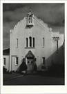
200 Lesmurdie Rd Lesmurdie
Registered as part of P16819 Lesmurdie Group
St Andrews Convalescent Home
St Andrews School
Kalamunda
Metropolitan
Constructed from 1913 to 1990
| Type | Status | Date | Documents |
|---|---|---|---|
| (no listings) |
| Type | Status | Date | Documents |
|---|---|---|---|
| (no listings) |
| Type | Status | Date | Grading/Management | |
|---|---|---|---|---|
| Category | ||||
| Municipal Inventory | Adopted | 01 Aug 2013 | Category 1 | |
16819 Lesmurdie Group
St Brigid’s College is in very good condition and has been well maintained. The grounds are in good condition.
| Name | Type | Year From | Year To |
|---|---|---|---|
| George Herbert Parry | Architect | 1913 | 1921 |
| Library Id | Title | Medium | Year Of Publication |
|---|---|---|---|
| 1172 | The changing face of Kalamunda : a collection of old and new photographs. Volume 2. | Book | 1987 |
| 9285 | St Brigid's College Lesmurdie, Western Australia. | Heritage Study {Cons'n Plan} | 2009 |
| 6604 | The changing face of Kalamunda : a collection of old and new photographs. Volume 1. | Book | 1982 |
Individual Building or Group
| Epoch | General | Specific |
|---|---|---|
| Other Use | HEALTH | Hospital |
| Present Use | EDUCATIONAL | Secondary School |
| Original Use | EDUCATIONAL | Primary School |
| Present Use | EDUCATIONAL | Combined School |
| Present Use | EDUCATIONAL | Housing or Quarters |
| Style |
|---|
| Federation Anglo-Dutch |
| Type | General | Specific |
|---|---|---|
| Roof | METAL | Corrugated Iron |
| Roof | TILE | Terracotta Tile |
| Wall | BRICK | Face Brick |
| Wall | STONE | Other Stone |
| Wall | BRICK | Rendered Brick |
| Wall | TIMBER | Weatherboard |
| General | Specific |
|---|---|
| SOCIAL & CIVIC ACTIVITIES | Community services & utilities |
| SOCIAL & CIVIC ACTIVITIES | Education & science |
This information is provided voluntarily as a public service. The information provided is made available in good faith and is derived from sources believed to be reliable and accurate. However, the information is provided solely on the basis that readers will be responsible for making their own assessment of the matters discussed herein and are advised to verify all relevant representations, statements and information.
Constructed from 1990, Constructed from 1913
The following statement is drawn from the Register Entry for the place used for its inclusion on the State Register of Heritage Places in 2005.
The building was designed in the Federation Anglo-Dutch style by architect, George Herbert Parry, as a literal translation of the Cape Dutch Revival style in a Western Australian setting. Typical of the style, the building has rendered and white-painted masonry walls, intricately modelled facades, three parapeted Dutch gables forming the main façade, and a verandah (also known as a stoep) running nearly the full length of the main façade with seats at both ends. The verandah is recessed between the two outer gable walls and supports a first floor balcony that features an intricate filigree balustrade. The original school building is constructed of rendered brick with a face- brick and laterite stone base, and has an enclosed courtyard plan. The (east) section was built in 1921 as an addition to the rear 1913 section and is two-storey with a basement level, has rendered masonry walls on a face-brick base, an original terracotta tile hipped roof, gable parapets on the east and west ends, and first floor balconies on the east and the west elevations (the balcony on the west has been enclosed). Attached directly to the two- storey front section, and stepping down with the topography of the site, is the single-storey rear section (also with a basement). The rear section is the original school building (1913) and has rendered masonry walls on a laterite stone base, a hipped corrugated iron roof, and a verandah along the western end. A weatherboard extension is suspended over the eastern verandah, similarly, the east wall of the westernmost wing facing the courtyard is weatherboard. The central courtyard is fully enclosed by the building fabric and has been considerably modified -. Internally, the plan of the 1913-21 building has a series of classrooms arranged around the central courtyard, with the enclosed verandah (now an internal corridor) forming the primary circulation space.
Technology, local heroes, education, religion, community services 1913/21 (orig. rear laterite stone building) 1938 (2 storey addition), 1965 (brick convent at rear), 1967-1990 - school buildings
Level of Integrity - High; Level of Authenticity - High
Good Archibald Sanderson was born at Glen Thompson, Victoria, in 1870, the fourth son of John Sanderson, who had founded (in 1858) the Melbourne firm of John Sanderson and Co, an agency of Sanderson and Murray, wool merchants of Galashiels, Scotland. In 1871, the family returned to England where John Sanderson became a partner in Sanderson and Murray’s London Branch in 1876. Archibald Sanderson was educated at Haileybury College in England, and later attended Oxford University. From 1892 until 1894, he worked as a journalist in New Zealand. In 1894, Sanderson came to Western Australia and cycled through the Coolgardie goldfields in the capacity of special correspondent of the Christchurch Press and the New Zealand Times. In Coolgardie, he had a short involvement with the mining industry but later in 1895, moved to Perth. There, Sanderson found work as assistant master of the Perth High School for a few months until joining the Perth Morning Herald as leader-writer and assistant-editor. While at the Perth High School Sanderson met E.W. ‘Paddy’ Haynes, who, in 1895, brought him to visit the Darling Range. Sanderson liked the country and, in 1897, bought (Lot 227) for £20. Sanderson worked in the city during the week and, on weekends, camped in a tent, spent his time clearing and developing his Hills block. After the completion of his home. Lesmurdie House, Sanderson put into place his vision of creating a village surrounding his estate. In 1913, Archibald Sanderson had a private day and boarding school, ‘St Andrews College’, built near Lesmurdie House & Estate where some of his own children, as well as children of other ‘respectable’ local families, attended. This building was designed by George Herbert Parry as a long two-storey rectangular structure, built of local laterite stone with a corrugated iron roof, which faced the entrance drive to Lesmurdie House & Estate. There were verandahs on both levels of the building with simple timber railing enclosing the upper level. The building was designed in the Cape Dutch style of the residence of Cecil Rhodes, and all subsequent South African presidents, ‘Groote Schur’, on the side of Table Mountain, near Cape Town. The school ran from its establishment around the end of 1913 until late 1919 or early 1920 until sold by Archibald Sanderson to the Red Cross Society. Subsequently, on 12 August 1920, the property was leased to the Commonwealth Repatriation Committee for use as a Soldiers’ Convalescent Home. In 1924, the Repatriation Department advised the Red Cross that the Kalamunda Convalescent Home would not be required after 31 October of that year. Immediately after this decision was known, the Board of the Perth Hospital opened negotiations with the Red Cross for the lease of the Kalamunda property as an auxiliary hospital for convalescents. Despite patient satisfaction with the auxiliary hospital success it was necessary to close the Kalamunda Auxiliary Hospital and In March 1929, the Red Cross accepted an offer for the purchase of ‘St Andrew’s’ Convalescent Home by the Sisters of Mercy who planned to establish a boarding school extension of St Brigid’s High School. The new St Brigid’s College, Lesmurdie commenced officially on 23 April 1929, with 36 boarders and three day girls During the 1930s and 1940s, St Brigid’s College was primarily a boarding school, staffed almost entirely by the Sisters of Mercy, who taught during the day and looked after the physical and emotional needs of the boarders during and after school hours. In 1938, a new building was constructed adjacent to the original building in a similar style. The school facilities have continued to expand since its inception and the ‘Heritage Building’ as the original building is known continues to be used by the school for educational purposes.
| Name | Type | Year From | Year To |
|---|---|---|---|
| Herbert Parry | Architect | 1913 | 1921 |
| Ref ID No | Ref Name | Ref Source | Ref Date |
|---|---|---|---|
| St Brigid's College; "School Yearbooks.". | |||
| Saunderson M; "Lesmurdie - A Home in the Hills". | 1979 | ||
| CHF, | 1979 | ||
| ALK, | 1978 | ||
| CFK, | 1982 |
| Reserve | Lot/Location | Plan/Diagram | Vol/Folio |
|---|---|---|---|
| Lot 9000 | Plan 61515 | 2705-57 |
| Owner | Category |
|---|---|
| Sisters of Mercy | Church Property |
This information is provided voluntarily as a public service. The information provided is made available in good faith and is derived from sources believed to be reliable and accurate. However, the information is provided solely on the basis that readers will be responsible for making their own assessment of the matters discussed herein and are advised to verify all relevant representations, statements and information.
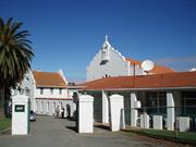
195 & 200 Lesmurdie Rd and 12 Catherine Pl Lesmurdie
(Inc St Swithun's and St Brigid's)
Kalamunda
Metropolitan
Constructed from 1898 to 1998
| Type | Status | Date | Documents |
|---|---|---|---|
| State Register | Registered | 28 Jun 2005 | HCWebsite.Listing+ListingDocument, HCWebsite.Listing+ListingDocument |
| Type | Status | Date | Documents |
|---|---|---|---|
| (no listings) |
| Type | Status | Date | Grading/Management | |
|---|---|---|---|---|
| Category | ||||
| (no listings) | ||||
Lesmurdie House & Estate is in good condition and has generally been well maintained. Parts of the interior fabric of the residence show signs of water damage, particularly the floor of the former Dining Room and ceiling of the enclosed front verandah. The former orchard store is in fair condition and shows considerable signs of wear. The verandah and roof need maintenance to stabilize their condition. Internally, the original fabric is in fair condition, with the floors and walls showing signs of deterioration caused by age and wear. The grounds of Lesmurdie House & Estate are in good condition and are well maintained. The brick and timber fence that edges the gravel terrace is in fair condition, although a number of fence palings are missing. The gardens, lawns and trees are well maintained. The concrete garden bathing-pool and Lesmurdie Brook are in good condition, although ducks currently inhabit the pool. St Brigid’s College is in very good condition and has been well maintained. The grounds are in good condition. St Swithun’s Church is in good condition and has been well maintained. The bushland garden setting has also been well maintained and contributes to the overall appearance of the place.
| Name | Type | Year From | Year To |
|---|---|---|---|
| George Herbert Parry | Architect | - | - |
| Library Id | Title | Medium | Year Of Publication |
|---|---|---|---|
| 9225 | Lesmurdie House St Brigid's College: Record of place | Archival Record | 2009 |
| 9285 | St Brigid's College Lesmurdie, Western Australia. | Heritage Study {Cons'n Plan} | 2009 |
Individual Building or Group
| Epoch | General | Specific |
|---|---|---|
| Present Use | EDUCATIONAL | Housing or Quarters |
| Original Use | RELIGIOUS | Housing or Quarters |
| Original Use | EDUCATIONAL | Primary School |
| Present Use | EDUCATIONAL | Secondary School |
| Other Use | HEALTH | Hospital |
| Original Use | RESIDENTIAL | Two storey residence |
| Original Use | RELIGIOUS | Church, Cathedral or Chapel |
| Present Use | EDUCATIONAL | Combined School |
| Style |
|---|
| Federation Queen Anne |
| Federation Anglo-Dutch |
| Federation Gothic |
| Type | General | Specific |
|---|---|---|
| Wall | TIMBER | Weatherboard |
| Roof | TILE | Terracotta Tile |
| Wall | BRICK | Rendered Brick |
| Roof | METAL | Corrugated Iron |
| Wall | STONE | Local Stone |
| Wall | BRICK | Face Brick |
| Wall | BRICK | Common Brick |
| General | Specific |
|---|---|
| SOCIAL & CIVIC ACTIVITIES | Education & science |
| PEOPLE | Famous & infamous people |
| DEMOGRAPHIC SETTLEMENT & MOBILITY | Settlements |
| SOCIAL & CIVIC ACTIVITIES | Religion |
This information is provided voluntarily as a public service. The information provided is made available in good faith and is derived from sources believed to be reliable and accurate. However, the information is provided solely on the basis that readers will be responsible for making their own assessment of the matters discussed herein and are advised to verify all relevant representations, statements and information.
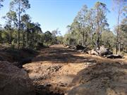
Bartons Mill Pickering Brook
16 km se of Kalamunda, forest Dept Map Ref: AY70, Mundaring 80
Kalamunda
Metropolitan
Constructed from 1942, Constructed from 1986
| Type | Status | Date | Documents |
|---|---|---|---|
| State Register | Registered | 26 Feb 1999 | HCWebsite.Listing+ListingDocument, HCWebsite.Listing+ListingDocument |
| Type | Status | Date | Documents |
|---|---|---|---|
| (no listings) |
| Type | Status | Date | Grading/Management | |
|---|---|---|---|---|
| Category | ||||
| Municipal Inventory | Adopted | 01 Aug 2013 | Category 1 | |
Remaining buildings are in a poor condition.
| Library Id | Title | Medium | Year Of Publication |
|---|---|---|---|
| 3335 | Bartons Mill Prison Pickering Brook WA - Heritage Assessment | Heritage Study {Other} | 1997 |
Individual Building or Group
| Epoch | General | Specific |
|---|---|---|
| Present Use | PARK\RESERVE | Park\Reserve |
| Original Use | FORESTRY | Timber Mill |
| Other Use | GOVERNMENTAL | Gaol |
| Type | General | Specific |
|---|---|---|
| Wall | CONCRETE | Concrete Block |
| Wall | ASBESTOS | Fibrous Cement, flat |
| Wall | BRICK | Face Brick |
| Roof | METAL | Corrugated Iron |
| Wall | TIMBER | Weatherboard |
| Roof | ASBESTOS | Fibrous Cement, corrugated |
| General | Specific |
|---|---|
| SOCIAL & CIVIC ACTIVITIES | Law & order |
| OCCUPATIONS | Timber industry |
| DEMOGRAPHIC SETTLEMENT & MOBILITY | Resource exploitation & depletion |
This information is provided voluntarily as a public service. The information provided is made available in good faith and is derived from sources believed to be reliable and accurate. However, the information is provided solely on the basis that readers will be responsible for making their own assessment of the matters discussed herein and are advised to verify all relevant representations, statements and information.
Constructed from 1948, Constructed from 1902
The following statement is drawn from the Register Documentation for the Permanent Entry of the Place on the State Register of Heritage Places in 1999
The site is predominantly regenerated scrub with some stone foundation walls still in evidence. The location of the remaining walls provide an indication of the extent and layout of the complex.
Timber, settlements, law and order, rail transport 1902 (Mill - since demolished) 1948 (Prison)
Level of Integrity - Low; Level of Authenticity - Low
Poor Alexander Barton started a timber mill in 1902 at Carilla, 2 miles from Pickering Brook. The timber was quickly stripped from this site and the mill was relocated to No. 4 mill. This was closed on Barton's death in 1908 and moved by the new owners, Millars, to its final location. The mill was burnt out and rebuilt in 1924 and continued to operate until 1937 when Millars closed the business. In 1942, the site was used by the State Government to house prisoners from Fremantle Prison which was occupied by the military during World War II. Additional buildings and security measures were added to the site to enable minimum security prisoners to be housed there. The premises were used for minimum security prisoners until 1989. The place was included on the State Register of Heritage Places in 1999.
| Ref ID No | Ref Name | Ref Source | Ref Date |
|---|---|---|---|
| Harper-Nelson B; "The History of Barton's Mill". | KDHS | 1977 | |
| CHF, pp. 50, 51, 53, 174, 189 |
| Reserve | Lot/Location | Plan/Diagram | Vol/Folio |
|---|---|---|---|
| Part State Forest Number 7, Part Crown Reserve 6203 | HCWA survey 3580 | CLR 3066/593 |
| Owner | Category |
|---|---|
| CALM | State Gov't |
This information is provided voluntarily as a public service. The information provided is made available in good faith and is derived from sources believed to be reliable and accurate. However, the information is provided solely on the basis that readers will be responsible for making their own assessment of the matters discussed herein and are advised to verify all relevant representations, statements and information.
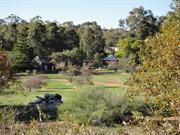
251 Stanhope Rd Walliston
Kalamunda
Metropolitan
Constructed from 1915
| Type | Status | Date | Documents |
|---|---|---|---|
| State Register | Registered | 20 Jul 2004 | HCWebsite.Listing+ListingDocument, HCWebsite.Listing+ListingDocument |
| Type | Status | Date | Documents |
|---|---|---|---|
| (no listings) |
| Type | Status | Date | Grading/Management | |
|---|---|---|---|---|
| Category | ||||
| Municipal Inventory | Adopted | 01 Aug 2013 | Category 1 | |
| Library Id | Title | Medium | Year Of Publication |
|---|---|---|---|
| 5954 | Levi Wallis cottage : final conservation works report. | Conservation works report | 2003 |
| 7588 | Levi Wallis' stables and dairy - final report : Final conservation works report | Conservation works report | 2005 |
| 5176 | Levi Wallis'Cottage : final report : interim conservation works report : grant allocation 1999/2000 / Considine and Griffiths Architects. | Heritage Study {Other} | 2001 |
| 4040 | Levi Wallis Dwelling, Walliston : conservation plan. | Heritage Study {Cons'n Plan} | 1999 |
Individual Building or Group
| Epoch | General | Specific |
|---|---|---|
| Original Use | RESIDENTIAL | Single storey residence |
| Present Use | VACANT\UNUSED | Vacant\Unused |
| Style |
|---|
| Vernacular |
| Type | General | Specific |
|---|---|---|
| Roof | METAL | Corrugated Iron |
| Wall | TIMBER | Other Timber |
| Wall | TIMBER | Slab |
| General | Specific |
|---|---|
| OCCUPATIONS | Domestic activities |
| DEMOGRAPHIC SETTLEMENT & MOBILITY | Land allocation & subdivision |
This information is provided voluntarily as a public service. The information provided is made available in good faith and is derived from sources believed to be reliable and accurate. However, the information is provided solely on the basis that readers will be responsible for making their own assessment of the matters discussed herein and are advised to verify all relevant representations, statements and information.
Constructed from 1913
The following statement is drawn from the Register entry for the inclusion of the place on the State Register of Heritage Places in 2004.
Set back from the roadside amidst a forested backdrop and open paddocks to the front. Small timber framed structure with vertical slab cladding, small timber framed casement windows, shallow pitched gable roof with short sheet corrugated galvanised iron. Rear lean-to section. Slab constructed stable block with gabled roof
Land allocation, technology, orchards, rail transport
Level of Integrity - High; Level of Authenticity - High
Good This simple cottage was built c1915 by Levi John Wallis (1874-1966). Levi’s father, John Wallis established a large orchard named ‘Orangedale’ and was an active member of the local community as a representative on the Roads Board and the Fruitgrowers association. John and Emma Wallis were the first landholders in the district and had eight children. Three sons, including Levi, took up land in the district and the area was named ‘Walliston’ in recognition of the family’s contribution. Levi Wallis was granted the land on which this cottage is located in 1895 and worked as a labourer and gardener in the district. He married Ada Morris in 1913 and the couple must have settled on this land soon after and built a basic shack to live in. This cottage was originally intended as a stable but the growing family moved in to it as apparently it was better than the shack. Levi and Ada had three children by 1916 and a fourth in 1921. Levi Wallis continued to work as a labourer finding work with the Roads Board clearing roads and later he secured employment with the Railways. The house was occupied until 1978 and then fell into disrepair. The current owners undertook conservation works in 2005 and the place is currently [2013] used for accommodation.
| Ref ID No | Ref Name | Ref Source | Ref Date |
|---|---|---|---|
| LSC No.s 192, 193, 1195 | Photographs |
| Reserve | Lot/Location | Plan/Diagram | Vol/Folio |
|---|---|---|---|
| Lot 22 | D55820 | 1535-880 |
This information is provided voluntarily as a public service. The information provided is made available in good faith and is derived from sources believed to be reliable and accurate. However, the information is provided solely on the basis that readers will be responsible for making their own assessment of the matters discussed herein and are advised to verify all relevant representations, statements and information.