Local Government
Plantagenet
Region
Great Southern
Also falls into Shire of Denmark
Plantagenet
Great Southern
Constructed from 1870
| Type | Status | Date | Documents |
|---|---|---|---|
| (no listings) |
| Type | Status | Date | Documents |
|---|---|---|---|
| (no listings) |
| Type | Status | Date | Grading/Management | |
|---|---|---|---|---|
| Category | ||||
| (no listings) | ||||
Landscape
| Epoch | General | Specific |
|---|---|---|
| Original Use | FARMING\PASTORAL | Other |
| Present Use | FARMING\PASTORAL | Other |
This information is provided voluntarily as a public service. The information provided is made available in good faith and is derived from sources believed to be reliable and accurate. However, the information is provided solely on the basis that readers will be responsible for making their own assessment of the matters discussed herein and are advised to verify all relevant representations, statements and information.
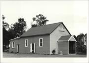
Forest Hill
Plantagenet
Great Southern
Constructed from 1910
| Type | Status | Date | Documents |
|---|---|---|---|
| (no listings) |
| Type | Status | Date | Documents |
|---|---|---|---|
| (no listings) |
| Type | Status | Date | Grading/Management | |
|---|---|---|---|---|
| Category | ||||
| (no listings) | ||||
Individual Building or Group
| Epoch | General | Specific |
|---|---|---|
| Original Use | SOCIAL\RECREATIONAL | Agricultural Hall |
| Present Use | SOCIAL\RECREATIONAL | Agricultural Hall |
This information is provided voluntarily as a public service. The information provided is made available in good faith and is derived from sources believed to be reliable and accurate. However, the information is provided solely on the basis that readers will be responsible for making their own assessment of the matters discussed herein and are advised to verify all relevant representations, statements and information.
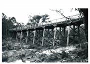
old alignment of south coast hwy Kalgan
Identified throug research into the nomination of P0089 Lower River Kalgan Bridge & Jetty.
Upper Kalgan Bridge
Plantagenet
Great Southern
| Type | Status | Date | Documents |
|---|---|---|---|
| (no listings) |
| Type | Status | Date | Documents |
|---|---|---|---|
| RHP - Does not warrant assessment | Current | 30 Jul 2021 |
| Type | Status | Date | Grading/Management | |
|---|---|---|---|---|
| Category | ||||
| (no listings) | ||||
| Library Id | Title | Medium | Year Of Publication |
|---|---|---|---|
| 7730 | Images CD No. 42: Stirling Terrace Precinct, Albany Courthouse complex, old Kalgan River Road bridge, new Kalgan River Road bridge. | C D Rom | 2006 |
Historic site
| Epoch | General | Specific |
|---|---|---|
| Original Use | Transport\Communications | Road: Bridge |
| Present Use | OTHER | Other |
| Type | General | Specific |
|---|---|---|
| Other | TIMBER | Log |
| General | Specific |
|---|---|
| TRANSPORT & COMMUNICATIONS | Road transport |
This information is provided voluntarily as a public service. The information provided is made available in good faith and is derived from sources believed to be reliable and accurate. However, the information is provided solely on the basis that readers will be responsible for making their own assessment of the matters discussed herein and are advised to verify all relevant representations, statements and information.
South Coast Hwy Kalgan
Identified through research into the nomination of P0089 Lower River Kalgan Bridge & Jetty. The bridge to the south is P16090 Old Kalgan River Road Bridge.
MRWA Bridge 891
Upper Kalgan River bridge (St wd tbr strctrs)
Plantagenet
Great Southern
Constructed from 1966
| Type | Status | Date | Documents |
|---|---|---|---|
| (no listings) |
| Type | Status | Date | Documents |
|---|---|---|---|
| (no listings) |
| Type | Status | Date | Grading/Management | |
|---|---|---|---|---|
| Category | ||||
| (no listings) | ||||
| Library Id | Title | Medium | Year Of Publication |
|---|---|---|---|
| 7730 | Images CD No. 42: Stirling Terrace Precinct, Albany Courthouse complex, old Kalgan River Road bridge, new Kalgan River Road bridge. | C D Rom | 2006 |
Other Built Type
| Epoch | General | Specific |
|---|---|---|
| Original Use | Transport\Communications | Road: Bridge |
| Present Use | Transport\Communications | Road: Bridge |
| Type | General | Specific |
|---|---|---|
| Other | TIMBER | Log |
| General | Specific |
|---|---|
| TRANSPORT & COMMUNICATIONS | Road transport |
This information is provided voluntarily as a public service. The information provided is made available in good faith and is derived from sources believed to be reliable and accurate. However, the information is provided solely on the basis that readers will be responsible for making their own assessment of the matters discussed herein and are advised to verify all relevant representations, statements and information.
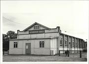
Cnr Albany Hwy & Jellicoe Rd Kendenup
Kalgan Hall
Kendenup / Keninup Homestead
Plantagenet
Great Southern
Constructed from 1868
| Type | Status | Date | Documents |
|---|---|---|---|
| State Register | Registered | 01 Jul 1994 | HCWebsite.Listing+ListingDocument |
| Type | Status | Date | Documents |
|---|---|---|---|
| (no listings) |
| Type | Status | Date | Grading/Management | |
|---|---|---|---|---|
| Category | ||||
| Municipal Inventory | Adopted | 24 Mar 1998 | ||
| Classified by the National Trust | Classified | 03 Aug 1992 | ||
| Register of the National Estate | Indicative Place | |||
| Library Id | Title | Medium | Year Of Publication |
|---|---|---|---|
| 3438 | Kendenup Farm - Kendenup WA Final Report | Report | 1998 |
| 5959 | Mrs Mulder's trough; Konnongoring Hall; Perenjori; Hawes, Mullewa; Lynton Heritage Site; Hassell Homestead. | Video | 1991 |
| 3642 | Kendenup : an historic farm : conservation plan. | Heritage Study {Cons'n Plan} | 1998 |
| 2033 | Kendenup : an historic farm 1840 : directions for conservation. | Heritage Study {Other} | 1994 |
| 3952 | Kendenup Farm Kendenup WA Final Report | Heritage Study {Other} | 1999 |
| 5020 | Kendenup Farm, Kendenup, WA. Final report. March 2001. | Report | 2001 |
Individual Building or Group
| Epoch | General | Specific |
|---|---|---|
| Original Use | FARMING\PASTORAL | Homestead |
| Present Use | FARMING\PASTORAL | Homestead |
| Style |
|---|
| Vernacular |
| Type | General | Specific |
|---|---|---|
| Other | EARTH | Adobe {Mud Brick} |
| Wall | BRICK | Common Brick |
| Roof | METAL | Corrugated Iron |
| General | Specific |
|---|---|
| OCCUPATIONS | Grazing, pastoralism & dairying |
This information is provided voluntarily as a public service. The information provided is made available in good faith and is derived from sources believed to be reliable and accurate. However, the information is provided solely on the basis that readers will be responsible for making their own assessment of the matters discussed herein and are advised to verify all relevant representations, statements and information.
Constructed from 1868
"The Homestead, associated farm buildings and brick kiln at Kendenup have a high degree of cultural significance. It is one of the few complete farm complexes in the region which, through a series of buildings, demonstrates the evolution and expansion of colonial farming activities and reflects the success of a prominent family of the district". The Hassell Family, with patriarch John Hassell, contributed greatly to the development of a successful wool producing farm "Kendenup" until it was sold in 1920. The farm was bought by C J De Garis who attempted a close settlement scheme, subdividing the estate into farm blocks of ten to sixty acres, with provision for a townsite with community services. The venture was not successful, and finally collapsed in 1923, owing to a combination of insufficient financial backing, small demand for the products and bad management. The property was sold. The Hassell property was also associated with a brief gold mining venture in 1874 when the Standard Gold Mining Company set up operations on Kendenup about a mile south of the Hassell homestead. Only ten tons of ore from the mine were crushed before it closed down 1876 without any significant yields recorded. The HCWA has recognised the heritage value of the Hassell Homestead by entering it on the WA Heritage Register. Kalgan Hall has been also extensively evaluated by the National Trust.
The Hassell Family, with patriarch John Hassell, contributed greatly to the development of a successful wool producing farm "Kendenup" until it was sold in 1920. The farm was bought by C J De Garis who attempted a close settlement scheme, subdividing the estate into farm blocks of ten to sixty acres, with provision for a townsite with community services. The venture was not successful, and finally collapsed in 1923, owing to a combination of insufficient financial backing, small demand for the products and bad management. The property was sold. The Hassell property was also associated with a brief gold mining venture in 1874 when the Standard Gold Mining Company set up operations on Kendenup about a mile south of the Hassell homestead. Only ten tons of ore from the mine were crushed before it closed down 1876 without any significant yields recorded.
| Ref ID No | Ref Name | Ref Source | Ref Date |
|---|---|---|---|
| Expansive collection of information held at HCWA and in Shire Heritage Files | State Heritage Office |
This information is provided voluntarily as a public service. The information provided is made available in good faith and is derived from sources believed to be reliable and accurate. However, the information is provided solely on the basis that readers will be responsible for making their own assessment of the matters discussed herein and are advised to verify all relevant representations, statements and information.
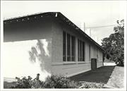
Austin St Kendenup
Kendenup School
Plantagenet
Great Southern
Constructed from 1921
| Type | Status | Date | Documents |
|---|---|---|---|
| (no listings) |
| Type | Status | Date | Documents |
|---|---|---|---|
| (no listings) |
| Type | Status | Date | Grading/Management | |
|---|---|---|---|---|
| Category | ||||
| Municipal Inventory | Adopted | 24 Mar 1998 | ||
Individual Building or Group
| Epoch | General | Specific |
|---|---|---|
| Original Use | EDUCATIONAL | Primary School |
| Present Use | EDUCATIONAL | Primary School |
| Type | General | Specific |
|---|---|---|
| Wall | BRICK | Common Brick |
| Wall | RENDER | Bagged |
| Roof | TILE | Cement Tile |
| General | Specific |
|---|---|
| SOCIAL & CIVIC ACTIVITIES | Education & science |
This information is provided voluntarily as a public service. The information provided is made available in good faith and is derived from sources believed to be reliable and accurate. However, the information is provided solely on the basis that readers will be responsible for making their own assessment of the matters discussed herein and are advised to verify all relevant representations, statements and information.
Constructed from 1921
| Owner | Category |
|---|---|
| Education Department | State Gov't |
This information is provided voluntarily as a public service. The information provided is made available in good faith and is derived from sources believed to be reliable and accurate. However, the information is provided solely on the basis that readers will be responsible for making their own assessment of the matters discussed herein and are advised to verify all relevant representations, statements and information.
Cnr Beverley St & Hassell Av Kendenup
Plantagenet
Great Southern
Constructed from 1934
| Type | Status | Date | Documents |
|---|---|---|---|
| (no listings) |
| Type | Status | Date | Documents |
|---|---|---|---|
| (no listings) |
| Type | Status | Date | Grading/Management | |
|---|---|---|---|---|
| Category | ||||
| Municipal Inventory | Adopted | 24 Mar 1998 | ||
Individual Building or Group
| Epoch | General | Specific |
|---|---|---|
| Present Use | SOCIAL\RECREATIONAL | Other Community Hall\Centre |
| Original Use | SOCIAL\RECREATIONAL | Other Community Hall\Centre |
| Type | General | Specific |
|---|---|---|
| Roof | METAL | Corrugated Iron |
| Wall | BRICK | Common Brick |
| Wall | ASBESTOS | Fibrous Cement, flat |
| General | Specific |
|---|---|
| SOCIAL & CIVIC ACTIVITIES | Community services & utilities |
This information is provided voluntarily as a public service. The information provided is made available in good faith and is derived from sources believed to be reliable and accurate. However, the information is provided solely on the basis that readers will be responsible for making their own assessment of the matters discussed herein and are advised to verify all relevant representations, statements and information.
Constructed from 1934
This information is provided voluntarily as a public service. The information provided is made available in good faith and is derived from sources believed to be reliable and accurate. However, the information is provided solely on the basis that readers will be responsible for making their own assessment of the matters discussed herein and are advised to verify all relevant representations, statements and information.
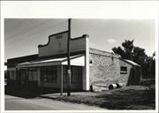
Hassell Av Kendenup
Plantagenet
Great Southern
Constructed from 1921
| Type | Status | Date | Documents |
|---|---|---|---|
| (no listings) |
| Type | Status | Date | Documents |
|---|---|---|---|
| (no listings) |
| Type | Status | Date | Grading/Management | |
|---|---|---|---|---|
| Category | ||||
| Municipal Inventory | Adopted | 24 Mar 1998 | ||
| Name | Type | Year From | Year To |
|---|---|---|---|
| Ridge Bros | Architect | - | - |
Individual Building or Group
| Epoch | General | Specific |
|---|---|---|
| Original Use | COMMERCIAL | Shop\Retail Store {single} |
| Present Use | COMMERCIAL | Shop\Retail Store {single} |
| Type | General | Specific |
|---|---|---|
| Wall | BRICK | Common Brick |
| Roof | METAL | Corrugated Iron |
| General | Specific |
|---|---|
| OCCUPATIONS | Commercial & service industries |
This information is provided voluntarily as a public service. The information provided is made available in good faith and is derived from sources believed to be reliable and accurate. However, the information is provided solely on the basis that readers will be responsible for making their own assessment of the matters discussed herein and are advised to verify all relevant representations, statements and information.
Constructed from 1921
This information is provided voluntarily as a public service. The information provided is made available in good faith and is derived from sources believed to be reliable and accurate. However, the information is provided solely on the basis that readers will be responsible for making their own assessment of the matters discussed herein and are advised to verify all relevant representations, statements and information.
55 Hassell Av Kendenup
Plantagenet
Great Southern
Constructed from 1921
| Type | Status | Date | Documents |
|---|---|---|---|
| (no listings) |
| Type | Status | Date | Documents |
|---|---|---|---|
| (no listings) |
| Type | Status | Date | Grading/Management | |
|---|---|---|---|---|
| Category | ||||
| Register of the National Estate | Indicative Place | |||
| Register of the National Estate | YES | |||
Individual Building or Group
| Epoch | General | Specific |
|---|---|---|
| Present Use | VACANT\UNUSED | Vacant\Unused |
| Original Use | INDUSTRIAL\MANUFACTURING | Bakery |
| Type | General | Specific |
|---|---|---|
| Roof | METAL | Corrugated Iron |
| Wall | BRICK | Common Brick |
| General | Specific |
|---|---|
| OCCUPATIONS | Commercial & service industries |
This information is provided voluntarily as a public service. The information provided is made available in good faith and is derived from sources believed to be reliable and accurate. However, the information is provided solely on the basis that readers will be responsible for making their own assessment of the matters discussed herein and are advised to verify all relevant representations, statements and information.
Jellicoe Rd Kendenup
Five Stamp Battery
Plantagenet
Great Southern
Constructed from 1874
| Type | Status | Date | Documents |
|---|---|---|---|
| (no listings) |
| Type | Status | Date | Documents |
|---|---|---|---|
| (no listings) |
| Type | Status | Date | Grading/Management | |
|---|---|---|---|---|
| Category | ||||
| Municipal Inventory | Adopted | 24 Mar 1998 | ||
| Classified by the National Trust | Classified | 06 Aug 1973 | ||
| Register of the National Estate | Permanent | 21 Oct 1980 | ||
Historic site
| Epoch | General | Specific |
|---|---|---|
| Present Use | VACANT\UNUSED | Vacant\Unused |
| Original Use | MINING | Mining Battery |
| Type | General | Specific |
|---|---|---|
| Other | TIMBER | Other Timber |
| General | Specific |
|---|---|
| OCCUPATIONS | Mining {incl. mineral processing} |
This information is provided voluntarily as a public service. The information provided is made available in good faith and is derived from sources believed to be reliable and accurate. However, the information is provided solely on the basis that readers will be responsible for making their own assessment of the matters discussed herein and are advised to verify all relevant representations, statements and information.
Constructed from 1874
| Ref ID No | Ref Name | Ref Source | Ref Date |
|---|---|---|---|
| R Glover; "Plantagenet Rich and Beautiful". |
This information is provided voluntarily as a public service. The information provided is made available in good faith and is derived from sources believed to be reliable and accurate. However, the information is provided solely on the basis that readers will be responsible for making their own assessment of the matters discussed herein and are advised to verify all relevant representations, statements and information.
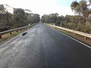
Muir Hwy Kenton
Over Kent River
MRWA Bridge 500
Plantagenet
Great Southern
| Type | Status | Date | Documents |
|---|---|---|---|
| (no listings) |
| Type | Status | Date | Documents |
|---|---|---|---|
| RHP - Does not warrant assessment | Current | 29 Nov 2019 |
| Type | Status | Date | Grading/Management | |
|---|---|---|---|---|
| Category | ||||
| (no listings) | ||||
The place is demonstrates the widespread use of timber as a structural material in twentieth century bridge building;
The place is associated with the growth of regional road infrastructure in the mid twentieth century as road began to replace rail.
Bridge 500, Muir Highway over Kent River, Perillup is a double lane timber, concrete and steel road bridge spanning the Kent River, approximately 45km west-northwest of the town of Mount Barker. The bridge is approximately 44m long, 7.6m wide and sits approximately 1m above the creek bed at its highest point. The bridge consists of 7 spans constructed along a west-northwest to east-southeast axis. The bridge abutments consist of dressed timber planks laid against an earth embankment, which has been further supported by timber logs planted upright against the planks. Some of these upright timber logs have since been replaced by galvanised steel members. The foundation of the abutment further appears to have been modified through the use of concrete blocks on at least one side.
In the region around Plantagenet, the Noongar groups known as the Ganeang, Goreng and Minang lived for tens of thousands of years, moving between the coast and inland forests to utilise the natural resources of the area. This way of life began to be disrupted after 1829 with the arrival of colonists, with farmers moving into the Plantagenet area after 1840. A small network of farms and orchards slowly developed over the next few decades, however this growth accelerated after 1890 with the arrival of railway transport and the increased demand for produce arising from the Gold Boom. By the Turn of the century, Plantagenet was a modestly sized but thriving mixed agricultural area.
Other Built Type
| Epoch | General | Specific |
|---|---|---|
| Original Use | Transport\Communications | Road: Bridge |
This information is provided voluntarily as a public service. The information provided is made available in good faith and is derived from sources believed to be reliable and accurate. However, the information is provided solely on the basis that readers will be responsible for making their own assessment of the matters discussed herein and are advised to verify all relevant representations, statements and information.
Mount Barker
Ungerup
Plantagenet
Great Southern
Constructed from 1894
| Type | Status | Date | Documents |
|---|---|---|---|
| (no listings) |
| Type | Status | Date | Documents |
|---|---|---|---|
| (no listings) |
| Type | Status | Date | Grading/Management | |
|---|---|---|---|---|
| Category | ||||
| Municipal Inventory | Adopted | 24 Mar 1998 | ||
Individual Building or Group
| Epoch | General | Specific |
|---|---|---|
| Original Use | RESIDENTIAL | Single storey residence |
| Present Use | VACANT\UNUSED | Vacant\Unused |
| Type | General | Specific |
|---|---|---|
| Roof | METAL | Corrugated Iron |
| Wall | EARTH | Adobe {Mud Brick} |
| General | Specific |
|---|---|
| DEMOGRAPHIC SETTLEMENT & MOBILITY | Settlements |
This information is provided voluntarily as a public service. The information provided is made available in good faith and is derived from sources believed to be reliable and accurate. However, the information is provided solely on the basis that readers will be responsible for making their own assessment of the matters discussed herein and are advised to verify all relevant representations, statements and information.
Constructed from 1894
Mrs Egerton-Warburton was the last resident, dying in 1982, she was buried at St Werburgh's Chapel.
This information is provided voluntarily as a public service. The information provided is made available in good faith and is derived from sources believed to be reliable and accurate. However, the information is provided solely on the basis that readers will be responsible for making their own assessment of the matters discussed herein and are advised to verify all relevant representations, statements and information.
Albany Hwy Mount Barker
1km north of Albany Highway
Plantagenet
Great Southern
Constructed from 1860
| Type | Status | Date | Documents |
|---|---|---|---|
| (no listings) |
| Type | Status | Date | Documents |
|---|---|---|---|
| (no listings) |
| Type | Status | Date | Grading/Management | |
|---|---|---|---|---|
| Category | ||||
| Municipal Inventory | Adopted | 24 Mar 1998 | ||
Place was demolished in 2006 to make way for a bypass.
| Library Id | Title | Medium | Year Of Publication |
|---|---|---|---|
| 8677 | Avoca, Mt Barker : archival record. | Archival Record | 2006 |
Individual Building or Group
| Epoch | General | Specific |
|---|---|---|
| Present Use | VACANT\UNUSED | Vacant\Unused |
| Original Use | RESIDENTIAL | Single storey residence |
| Type | General | Specific |
|---|---|---|
| Roof | METAL | Corrugated Iron |
| Wall | BRICK | Common Brick |
| General | Specific |
|---|---|
| SOCIAL & CIVIC ACTIVITIES | Law & order |
This information is provided voluntarily as a public service. The information provided is made available in good faith and is derived from sources believed to be reliable and accurate. However, the information is provided solely on the basis that readers will be responsible for making their own assessment of the matters discussed herein and are advised to verify all relevant representations, statements and information.
Constructed from 1860
| Ref ID No | Ref Name | Ref Source | Ref Date |
|---|---|---|---|
| Photo of original building in Museum Photo Collection. |
This information is provided voluntarily as a public service. The information provided is made available in good faith and is derived from sources believed to be reliable and accurate. However, the information is provided solely on the basis that readers will be responsible for making their own assessment of the matters discussed herein and are advised to verify all relevant representations, statements and information.
Albany Hwy Mount Barker
Plantagenet
Great Southern
Constructed from 1960
| Type | Status | Date | Documents |
|---|---|---|---|
| (no listings) |
| Type | Status | Date | Documents |
|---|---|---|---|
| (no listings) |
| Type | Status | Date | Grading/Management | |
|---|---|---|---|---|
| Category | ||||
| Uniting Church Inventory | Completed | 01 Oct 1996 | ||
Individual Building or Group
| Epoch | General | Specific |
|---|---|---|
| Original Use | RELIGIOUS | Church, Cathedral or Chapel |
| Present Use | RELIGIOUS | Church, Cathedral or Chapel |
| Type | General | Specific |
|---|---|---|
| Roof | ASBESTOS | Fibrous Cement, corrugated |
| Wall | BRICK | Common Brick |
| General | Specific |
|---|---|
| SOCIAL & CIVIC ACTIVITIES | Religion |
This information is provided voluntarily as a public service. The information provided is made available in good faith and is derived from sources believed to be reliable and accurate. However, the information is provided solely on the basis that readers will be responsible for making their own assessment of the matters discussed herein and are advised to verify all relevant representations, statements and information.
Albany Hwy Mount Barker
Plantagenet
Great Southern
Constructed from 1884
| Type | Status | Date | Documents |
|---|---|---|---|
| (no listings) |
| Type | Status | Date | Documents |
|---|---|---|---|
| (no listings) |
| Type | Status | Date | Grading/Management | |
|---|---|---|---|---|
| Category | ||||
| Municipal Inventory | Adopted | 24 Mar 1998 | ||
Historic Site
| Epoch | General | Specific |
|---|---|---|
| Present Use | OTHER | Other |
| Original Use | OTHER | Other |
| General | Specific |
|---|---|
| SOCIAL & CIVIC ACTIVITIES | Community services & utilities |
This information is provided voluntarily as a public service. The information provided is made available in good faith and is derived from sources believed to be reliable and accurate. However, the information is provided solely on the basis that readers will be responsible for making their own assessment of the matters discussed herein and are advised to verify all relevant representations, statements and information.
Constructed from 1884
This information is provided voluntarily as a public service. The information provided is made available in good faith and is derived from sources believed to be reliable and accurate. However, the information is provided solely on the basis that readers will be responsible for making their own assessment of the matters discussed herein and are advised to verify all relevant representations, statements and information.

Albany Hwy Mount Barker
Student Hostel
Plantagenet
Great Southern
Constructed from 1908
| Type | Status | Date | Documents |
|---|---|---|---|
| (no listings) |
| Type | Status | Date | Documents |
|---|---|---|---|
| (no listings) |
| Type | Status | Date | Grading/Management | |
|---|---|---|---|---|
| Category | ||||
| Municipal Inventory | Adopted | 24 Mar 1998 | ||
Individual Building or Group
| Epoch | General | Specific |
|---|---|---|
| Present Use | EDUCATIONAL | Housing or Quarters |
| Original Use | GOVERNMENTAL | Police Station or Quarters |
| Other Use | EDUCATIONAL | Housing or Quarters |
| Type | General | Specific |
|---|---|---|
| Wall | BRICK | Common Brick |
| Roof | METAL | Corrugated Iron |
| General | Specific |
|---|---|
| SOCIAL & CIVIC ACTIVITIES | Law & order |
This information is provided voluntarily as a public service. The information provided is made available in good faith and is derived from sources believed to be reliable and accurate. However, the information is provided solely on the basis that readers will be responsible for making their own assessment of the matters discussed herein and are advised to verify all relevant representations, statements and information.
Constructed from 1908
| Ref ID No | Ref Name | Ref Source | Ref Date |
|---|---|---|---|
| National Tmst assessment form in Shire heritage files. |
This information is provided voluntarily as a public service. The information provided is made available in good faith and is derived from sources believed to be reliable and accurate. However, the information is provided solely on the basis that readers will be responsible for making their own assessment of the matters discussed herein and are advised to verify all relevant representations, statements and information.
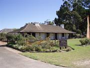
Albany Hwy Mount Barker
applroximately 6km north of Mt Barker
Chateau Barker Winery
Williams Rest
Plantagenet
Great Southern
Constructed from 1884
| Type | Status | Date | Documents |
|---|---|---|---|
| (no listings) |
| Type | Status | Date | Documents |
|---|---|---|---|
| (no listings) |
| Type | Status | Date | Grading/Management | |
|---|---|---|---|---|
| Category | ||||
| Municipal Inventory | Adopted | 24 Mar 1998 | ||
Shire was not able to confirm demolition, but suggests the place may no longer be extant.
Individual Building or Group
| Epoch | General | Specific |
|---|---|---|
| Other Use | INDUSTRIAL\MANUFACTURING | Winery |
| Original Use | RESIDENTIAL | Single storey residence |
| Present Use | VACANT\UNUSED | Vacant\Unused |
| Type | General | Specific |
|---|---|---|
| Roof | METAL | Corrugated Iron |
| Wall | BRICK | Common Brick |
| General | Specific |
|---|---|
| OCCUPATIONS | Rural industry & market gardening |
This information is provided voluntarily as a public service. The information provided is made available in good faith and is derived from sources believed to be reliable and accurate. However, the information is provided solely on the basis that readers will be responsible for making their own assessment of the matters discussed herein and are advised to verify all relevant representations, statements and information.
Constructed from 1884
Williams Rest has aesthetic and historical significance It is one of the early buildings in the district, dating back to 1884. Various changes have been made over time, but the original structure is basically intact. It is known as Williams Rest because of its association with the Williams family and the death of young Benjamin Williams, son of John and Susan Williams, the original owners.
Originally called "Peerimbup", the property passed to their son Frank and Stella Williams, who continued to tend the orchards. When Frank died in 1963 the property was sold. Mrs Williams died in 1994. .Subsequent owners over the next decade included Bill Bonney. Mr and Mrs Dorling and Garth Roberts. Another phase began in 1972-3 when Donald and Margaret Cooper took over the property. They planted 35 acres of vines and named the property Chateau Barker. It was about the 8th vineyard to be planted in the Great Southern District and a winery was established in 1981. with their son James Cooper as Winemaker. The vineyards produced medal -winning wines at all Australian Royal Shows, and the wines were sold all over Australia and overseas. Another son. David, trained as a cooper, and his skills were used Australia wide. In 1988 the property was sold to Goundrey Wines and was renamed Williams Rest. The house was altered slighty and became a wine-tasting centre. In 1995 the property was sold to Blue Wren Estates Ltd. The new owners have re-established approx 12 ha (30 acres) of vines which are once again productive. Wine is produced under the Williams Rest label, and there are plans to use the house for cellar sales once again.
| Ref ID No | Ref Name | Ref Source | Ref Date |
|---|---|---|---|
| Oral History. Sehvyn Wines. Sean Johnson. | |||
| Oral History. Williams family: Shervl Hilgeri. | |||
| Oral History. Cooper family: Donald and Margaret Cooper. |
| Owner | Category |
|---|---|
| Blue Wren Estates Ltd. | Other Private |
This information is provided voluntarily as a public service. The information provided is made available in good faith and is derived from sources believed to be reliable and accurate. However, the information is provided solely on the basis that readers will be responsible for making their own assessment of the matters discussed herein and are advised to verify all relevant representations, statements and information.
Albany Hwy Mount Barker
Mount Barker Museum
Plantagenet
Great Southern
Constructed from 1867
| Type | Status | Date | Documents |
|---|---|---|---|
| Heritage List | Adopted | 17 Feb 2021 | |
| State Register | Registered | 07 Oct 1997 | HCWebsite.Listing+ListingDocument, HCWebsite.Listing+ListingDocument |
| Type | Status | Date | Documents |
|---|---|---|---|
| (no listings) |
| Type | Status | Date | Grading/Management | |
|---|---|---|---|---|
| Category | ||||
| Register of the National Estate | Registered | 21 May 1991 | ||
| Classified by the National Trust | Classified | 03 Mar 1992 | ||
| Register of the National Estate | Nominated | 18 Mar 1983 | ||
| Municipal Inventory | Adopted | 24 Mar 1998 | ||
| Library Id | Title | Medium | Year Of Publication |
|---|---|---|---|
| 6426 | A preliminary study of convict sites in Western Australia (draft). | Heritage Study {Other} | 1997 |
Individual Building or Group
| Epoch | General | Specific |
|---|---|---|
| Original Use | GOVERNMENTAL | Police Station or Quarters |
| Present Use | EDUCATIONAL | Museum |
| Style |
|---|
| Victorian Georgian |
| Type | General | Specific |
|---|---|---|
| Roof | METAL | Corrugated Iron |
| Wall | STONE | Other Stone |
| Roof | TIMBER | Shingle |
| General | Specific |
|---|---|
| SOCIAL & CIVIC ACTIVITIES | Law & order |
This information is provided voluntarily as a public service. The information provided is made available in good faith and is derived from sources believed to be reliable and accurate. However, the information is provided solely on the basis that readers will be responsible for making their own assessment of the matters discussed herein and are advised to verify all relevant representations, statements and information.
Constructed from 1867, Constructed from 1987
The police station complex is significant as it is a very good example of convict style architecture. It has been recognised as having heritage significance by the Australian Heritage Council and was placed on the Interim Register of the National Estate in 1990.
Built in 1867, it was opened in 1868 with PC Daniel I'Connell in charge, The families of the policemen also lived at the station. A lockup was added to the stables in 1887. The station filled a vital public role, not only as a focus of law and order, but also as a telegraph office and a stopping place for the mail coaches travelling between Perth and Albany. It was also an administrative centre and courthouse visited by the Resident Magistrate. The police station was closed in 1908 and had various uses until transformed in the Museum by the Historical Society in 1968 with complete restoration taking place between 1985-87. It has been recognised as having heritage significance by the Australian Heritage Council and was placed on the Interim Register of the National Estate in 1990.
| Ref ID No | Ref Name | Ref Source | Ref Date |
|---|---|---|---|
| Supporting information from Heritage Council of WA Files (stored with original form) |
This information is provided voluntarily as a public service. The information provided is made available in good faith and is derived from sources believed to be reliable and accurate. However, the information is provided solely on the basis that readers will be responsible for making their own assessment of the matters discussed herein and are advised to verify all relevant representations, statements and information.
Albany Hwy Mount Barker
Plantagenet
Great Southern
Constructed from 1889
| Type | Status | Date | Documents |
|---|---|---|---|
| (no listings) |
| Type | Status | Date | Documents |
|---|---|---|---|
| (no listings) |
| Type | Status | Date | Grading/Management | |
|---|---|---|---|---|
| Category | ||||
| Municipal Inventory | Adopted | 24 Mar 1998 | ||
Individual Building or Group
| Epoch | General | Specific |
|---|---|---|
| Present Use | RESIDENTIAL | Single storey residence |
| Original Use | RESIDENTIAL | Single storey residence |
| Other Use | FARMING\PASTORAL | Homestead |
| Type | General | Specific |
|---|---|---|
| Wall | ASBESTOS | Fibrous Cement, flat |
| Wall | EARTH | Adobe {Mud Brick} |
| Roof | METAL | Corrugated Iron |
| General | Specific |
|---|---|
| DEMOGRAPHIC SETTLEMENT & MOBILITY | Settlements |
This information is provided voluntarily as a public service. The information provided is made available in good faith and is derived from sources believed to be reliable and accurate. However, the information is provided solely on the basis that readers will be responsible for making their own assessment of the matters discussed herein and are advised to verify all relevant representations, statements and information.
Constructed from 1886
The Rookery is built on the first 40 acre block granted in the area. The cost was £20 and was granted on 20 August 1886. Later (1896) a further 100 acres was allocated to J C Hicks, a blacksmith. The property had on it a blacksmith shop, a well (Hick's Well), the first golf club (1925) and the baker's ovens from which Mrs Hicks produced bread for sale. Mrs Hicks was known as a tireless worker. She had much community spirit and helped many people.
This information is provided voluntarily as a public service. The information provided is made available in good faith and is derived from sources believed to be reliable and accurate. However, the information is provided solely on the basis that readers will be responsible for making their own assessment of the matters discussed herein and are advised to verify all relevant representations, statements and information.
11 Albany Hwy Mount Barker
Old Mount Barker Station House
Westrail House
Plantagenet
Great Southern
Constructed from 1924
| Type | Status | Date | Documents |
|---|---|---|---|
| (no listings) |
| Type | Status | Date | Documents |
|---|---|---|---|
| (no listings) |
| Type | Status | Date | Grading/Management | |
|---|---|---|---|---|
| Category | ||||
| Municipal Inventory | Adopted | 24 Mar 1998 | ||
Individual Building or Group
| Epoch | General | Specific |
|---|---|---|
| Present Use | COMMERCIAL | Shop\Retail Store {single} |
| Original Use | Transport\Communications | Rail: Housing or Quarters |
| Type | General | Specific |
|---|---|---|
| Roof | METAL | Corrugated Iron |
| Wall | RENDER | Cement Dressed |
| Wall | BRICK | Common Brick |
| General | Specific |
|---|---|
| TRANSPORT & COMMUNICATIONS | Rail & light rail transport |
This information is provided voluntarily as a public service. The information provided is made available in good faith and is derived from sources believed to be reliable and accurate. However, the information is provided solely on the basis that readers will be responsible for making their own assessment of the matters discussed herein and are advised to verify all relevant representations, statements and information.
Constructed from 1924
This information is provided voluntarily as a public service. The information provided is made available in good faith and is derived from sources believed to be reliable and accurate. However, the information is provided solely on the basis that readers will be responsible for making their own assessment of the matters discussed herein and are advised to verify all relevant representations, statements and information.