Local Government
Swan
Region
Metropolitan
Baskerville
Baskerville Hall
Swan
Metropolitan
Constructed from 1923
| Type | Status | Date | Documents |
|---|---|---|---|
| (no listings) |
| Type | Status | Date | Documents |
|---|---|---|---|
| (no listings) |
| Type | Status | Date | Grading/Management | |
|---|---|---|---|---|
| Category | ||||
| Statewide War Memorial Survey | Completed | 01 May 1996 | ||
Individual Building or Group
| Epoch | General | Specific |
|---|---|---|
| Present Use | MONUMENT\CEMETERY | Monument |
| Original Use | MONUMENT\CEMETERY | Monument |
| General | Specific |
|---|---|
| OUTSIDE INFLUENCES | World Wars & other wars |
This information is provided voluntarily as a public service. The information provided is made available in good faith and is derived from sources believed to be reliable and accurate. However, the information is provided solely on the basis that readers will be responsible for making their own assessment of the matters discussed herein and are advised to verify all relevant representations, statements and information.
130 Memorial Av Baskerville
Municipal Inventory No: 536
Swan
Metropolitan
Constructed from 1886
| Type | Status | Date | Documents |
|---|---|---|---|
| Heritage List | Adopted | 30 Aug 2017 | |
| Heritage List | YES | 15 Dec 2010 |
| Type | Status | Date | Documents |
|---|---|---|---|
| (no listings) |
| Type | Status | Date | Grading/Management | |
|---|---|---|---|---|
| Category | ||||
| Municipal Inventory | Adopted | 25 Jun 1997 | Considerable Significance | |
Individual Building or Group
| Epoch | General | Specific |
|---|---|---|
| Original Use | FARMING\PASTORAL | Homestead |
| Present Use | FARMING\PASTORAL | Homestead |
| General | Specific |
|---|---|
| DEMOGRAPHIC SETTLEMENT & MOBILITY | Settlements |
This information is provided voluntarily as a public service. The information provided is made available in good faith and is derived from sources believed to be reliable and accurate. However, the information is provided solely on the basis that readers will be responsible for making their own assessment of the matters discussed herein and are advised to verify all relevant representations, statements and information.
Constructed from 1886, Constructed from 1984
Significant for associations with the original Baskerville Estate of William Tanner and subsequently Walter Padbury and Henry Hardwick. Historically and socially significant as one of the earliest estates settled in the Swan Valley and subsequently for associations with the further subdivision of the Valley in the early 1900s.
The homestead originally consisted of a central block with wings to the north and south with a gabled roof. The building was extended and extensively altered in 1974. The extensions and modifications are unsympathetic with the remaining original fabric.
Baskerville Estate was originally the property of William Tanner who left WA in 1835. In the 1880s it was bought by Walter Padbury who employed his relative Henry Hardwick to manage Baskerville. The homestead was built for Hardwick who bought the property from Padbury in the 1890s. The estate was subsequently subdivided.
Low
Fair
This information is provided voluntarily as a public service. The information provided is made available in good faith and is derived from sources believed to be reliable and accurate. However, the information is provided solely on the basis that readers will be responsible for making their own assessment of the matters discussed herein and are advised to verify all relevant representations, statements and information.
61 Memorial Av Baskerville
Municipal No: 537
Swan
Metropolitan
Constructed from 1920
| Type | Status | Date | Documents |
|---|---|---|---|
| (no listings) |
| Type | Status | Date | Documents |
|---|---|---|---|
| (no listings) |
| Type | Status | Date | Grading/Management | |
|---|---|---|---|---|
| Category | ||||
| Municipal Inventory | Adopted | 30 Aug 2017 | Category 3 | |
| Municipal Inventory | Adopted | 25 Jun 1997 | Significant | |
Individual Building or Group
| Epoch | General | Specific |
|---|---|---|
| Original Use | FARMING\PASTORAL | Cottage |
| Present Use | FARMING\PASTORAL | Cottage |
| General | Specific |
|---|---|
| DEMOGRAPHIC SETTLEMENT & MOBILITY | Settlements |
This information is provided voluntarily as a public service. The information provided is made available in good faith and is derived from sources believed to be reliable and accurate. However, the information is provided solely on the basis that readers will be responsible for making their own assessment of the matters discussed herein and are advised to verify all relevant representations, statements and information.
Constructed from 1920 to 1930
Reflects the history of settlement of the Swan Valley.
Timber framed house overlooking Swan Valley. House clad in weatherboard to dado height with fibro above corrugated iron hipped roof with verandahs around the building. Some windows original, some more recent. Turned posts and balustrades not original. The house was extensively restored, with a garage, other additions and alterations undertaken in 2007.
The place is associated with the many subdivisions which took place in the Swan Valley in the interwar period.
Moderately intact - some of the fabric is original.
Good
This information is provided voluntarily as a public service. The information provided is made available in good faith and is derived from sources believed to be reliable and accurate. However, the information is provided solely on the basis that readers will be responsible for making their own assessment of the matters discussed herein and are advised to verify all relevant representations, statements and information.
77 Memorial Av Baskerville
Municipal Inventory No: 538
Swan
Metropolitan
Constructed from 1910
| Type | Status | Date | Documents |
|---|---|---|---|
| (no listings) |
| Type | Status | Date | Documents |
|---|---|---|---|
| (no listings) |
| Type | Status | Date | Grading/Management | |
|---|---|---|---|---|
| Category | ||||
| Municipal Inventory | Adopted | 30 Aug 2017 | Category 3 | |
| Municipal Inventory | Adopted | 25 Jun 1997 | Significant | |
Individual Building or Group
| Epoch | General | Specific |
|---|---|---|
| Original Use | RESIDENTIAL | Single storey residence |
| Present Use | RESIDENTIAL | Single storey residence |
| Type | General | Specific |
|---|---|---|
| Wall | BRICK | Common Brick |
| General | Specific |
|---|---|
| DEMOGRAPHIC SETTLEMENT & MOBILITY | Settlements |
This information is provided voluntarily as a public service. The information provided is made available in good faith and is derived from sources believed to be reliable and accurate. However, the information is provided solely on the basis that readers will be responsible for making their own assessment of the matters discussed herein and are advised to verify all relevant representations, statements and information.
Constructed from 1910
Historic and social significance representing the history of settlement of the Swan Valley and the subdivision of the area in the early 1900s.
Painted brick cottage with double hung sash windows and fanlight over the central front door. Hipped roof with a front verandah. Roof sheeting has been replaced with zincalume. Brickwork to the front verandah is not original. Stetcherbond brickwork indicating cavity wall construction. Small brick extension to rear.
A 1910 brick and iron residence. Has been re-roofed, but still retains the typical characteristics of its era.
Fair
Fair
This information is provided voluntarily as a public service. The information provided is made available in good faith and is derived from sources believed to be reliable and accurate. However, the information is provided solely on the basis that readers will be responsible for making their own assessment of the matters discussed herein and are advised to verify all relevant representations, statements and information.
Memorial Ave Baskerville
on the southern bank of the Swan River
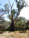
Stirling Tree
Swan
Metropolitan
Constructed from 1829
| Type | Status | Date | Documents |
|---|---|---|---|
| Heritage List | Adopted | 30 Aug 2017 | |
| State Register | Registered | 22 Apr 2016 | HCWebsite.Listing+ListingDocument, HCWebsite.Listing+ListingDocument |
| Type | Status | Date | Documents |
|---|---|---|---|
| (no listings) |
| Type | Status | Date | Grading/Management | |
|---|---|---|---|---|
| Category | ||||
| (no listings) | ||||
The place is a tangible reminder of the earliest land grnats in the Swan River colony, and is associated with the lives and work of both Governor James Stirling and John Septimus Roe
The boundary marker is a Eucalypt, still alive be badly burnt from a preivous fire, adjacent to the Swan River east of the junction with Ellensbrook.
The area was first visited by James Stirilng while exploring the Swan River in 1827. He returned with Roe and a group of colonists in 1829 to establish land grants. This tree was marked as the boundary between Swan Locations 4 and 5.
| Library Id | Title | Medium | Year Of Publication |
|---|---|---|---|
| 10230 | Beyond the Stirling Tree | Book | 2012 |
Tree
| Epoch | General | Specific |
|---|---|---|
| Original Use | OTHER | Other |
| Present Use | OTHER | Other |
| General | Specific |
|---|---|
| DEMOGRAPHIC SETTLEMENT & MOBILITY | Exploration & surveying |
This information is provided voluntarily as a public service. The information provided is made available in good faith and is derived from sources believed to be reliable and accurate. However, the information is provided solely on the basis that readers will be responsible for making their own assessment of the matters discussed herein and are advised to verify all relevant representations, statements and information.
Constructed from 1829
The place is a rare remnant of the early British exploration and survey of the Swan River Valley, marking the boundary of Swan Locations 4 and 5 which were amongst the earliest land grants in the Swan River Colony; The place was used to establish land boundaries by James Stirling, who explored the Swan River in 1827 and returned in 1829 as the first Governor of Western Australia; and by Surveyor General John Septimus Roe, who was responsible for surveying many of the earliest land grants in the colony; The place is rare as a known extant example of a tree used as a boundary marker that still serves its original purpose; the place demonstrates the early methods of surveying boundaries used by the British settlers; and The place continues to perform the function as a boundary tree, marking the extent of current lots in the area.
The Boundary Tree consists of a single Flooded Gum (Eucalyptus rudis), growing on the south side of the Swan River where it flows along an east-west axis through Baskerville. The tree itself is approximately 20 metres high with a diameter of 2.0 metres to 2.5 metres. The Boundary Tree is living but has sustained a great deal of damage including burn scars, termite holes and is now missing a number of the uppermost limbs. In particular, a section of the bark on the southern face of the tree is no longer extant, and is considered to have been burnt off in a lightning strike. The tree surface is also covered in numerous nodules. Despite this, the tree is putting forth fresh green branches. No signs of artificial modification such as deliberate scarring or the carving of symbols are apparent. If such marks existed, they may have been obscured or removed by burning.
In September 1829, Captain Stirling and Surveyor General, John Septimus Roe, travelled to the head of the Swan River above Guildford with a group of settlers to whom permission had been given to select land. These were among the first rural land grants in the Colony. An extract of a letter from a settler who was present at this survey states: After walking some distance... we arrived at the source of the river, called Ellen’s Brook. Here the river is very narrow. The Governor next declared the land from this point for four miles down the river, to be appropriated to Mr L-, one of our party, who had a preference... The Governor made other grants, distinguishing each by marking the trees. As the survey of the grant locations were performed by a group of government surveyors marking out boundaries using a compass, disputes over boundary locations were inevitable. Captain William Shaw and his neighbour to the north, Peter Brown of ‘Coulston,’ could not agree on a boundary between their properties and even asked Henry Bull, William Tanner and George Fletcher Moore to mark an independent boundary line. The trees marked by Stirling in 1829 were re-used by J W Gregory as part of a government contract survey of the Swan in 1842, where the tree is described as ‘Tanner’s Northern Boundary Tree. An intriguing detail of this map is a tree symbol marking the location of the ‘Success Tree (dead)’, west and downstream from Boundary Tree, Swan Locations 4 and 5, Baskerville. This may represent the site of Stirling’s furthest point upstream in his 1827 exploration, and the location generally corresponds to Stirling’s map of this journey. Captain Shaw continued to live at Swan Location 4 until his death in 1862, the estate managed by his wife Eliza Shaw and their son George Shaw until it was sold in 1876 to W T Loton. A more substantial homestead was eventually built at the place by the Loton family c.1887. The Loton family continued to live at the place until 1962. Boundary Tree, Swan Locations 4 and 5, Baskerville continued to mark the boundary of Locations 4 & 5 as the area developed, and by 1936 the Locations had become subdivided. The new lots 67 and 68 (formerly part of Location 5) were divided by Amiens Crescent, the Boundary Tree, Swan Locations 4 and 5, Baskerville intersection of Locations 4 & 5 becoming the western boundary of the road reserve where it meets the Swan River. In 2004, the Eucalypt at the end of Amiens Crescent was identified by Dr. Shane Burke as the tree marked by Stirling in 1829. A description of the tree at this time indicated that bark had been removed from the tree’s south side. A photo of the tree taken by Dr. Burke shows a large section of the tree’s surface as missing, presumed damaged in a bushfire. In 2017 substantial flooding overwhelmed the tree and it was further damaged.
High
Good
This information is provided voluntarily as a public service. The information provided is made available in good faith and is derived from sources believed to be reliable and accurate. However, the information is provided solely on the basis that readers will be responsible for making their own assessment of the matters discussed herein and are advised to verify all relevant representations, statements and information.
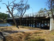
Guildford Rd Bassendean
Municipal Inventory No: 683 H.26 at SLKm 9.26 Map 2, UF3
Guildford Road Bridge over Swan River
MRWA 910, Bassendean Bridge
Swan
Metropolitan
Constructed from 1937
| Type | Status | Date | Documents |
|---|---|---|---|
| Heritage List | Adopted | 22 May 2018 | |
| Heritage List | Adopted | 30 Aug 2017 | |
| State Register | Registered | 22 Nov 2005 | HCWebsite.Listing+ListingDocument, HCWebsite.Listing+ListingDocument |
| Type | Status | Date | Documents |
|---|---|---|---|
| (no listings) |
| Type | Status | Date | Grading/Management | |
|---|---|---|---|---|
| Category | ||||
| Municipal Inventory | Adopted | 22 Aug 2017 | 1 | |
| Statewide Lge Timber Str Survey | Completed | 11 Dec 1998 | ||
| Classified by the National Trust | Classified | 11 Apr 2005 | ||
| Municipal Inventory | Adopted | 31 Oct 1996 | Category 3 | |
02915 Guildford Historic Town
Guildford Road Bridge is generally in good condition.
| Name | Type | Year From | Year To |
|---|---|---|---|
| E.W. (Ernie) Godfrey | Architect | - | - |
| Library Id | Title | Medium | Year Of Publication |
|---|---|---|---|
| 9530 | Swan and Helena rivers regional recreational path development plan. | Report | 2009 |
| 9531 | Swan and Helena rivers management framework: heritage audit and statement of significance, final report 26 February 2009. | Heritage Study {Other} | 2009 |
| 11995 | Report : Maintenance of Timber Bridges in the Metropolitian region. | Heritage Study {Other} | 2021 |
| 5386 | Bassendean bridge heritage plan. | Heritage Study {Cons'n Plan} | 2000 |
Other Built Type
| Epoch | General | Specific |
|---|---|---|
| Original Use | Transport\Communications | Road: Bridge |
| Present Use | Transport\Communications | Road: Bridge |
| Style |
|---|
| Other Style |
| Type | General | Specific |
|---|---|---|
| Other | CONCRETE | Other Concrete |
| Other | TIMBER | Other Timber |
| General | Specific |
|---|---|
| DEMOGRAPHIC SETTLEMENT & MOBILITY | Settlements |
| TRANSPORT & COMMUNICATIONS | Road transport |
This information is provided voluntarily as a public service. The information provided is made available in good faith and is derived from sources believed to be reliable and accurate. However, the information is provided solely on the basis that readers will be responsible for making their own assessment of the matters discussed herein and are advised to verify all relevant representations, statements and information.
Constructed from 2000, Constructed from 1983, Constructed from 1979, Constructed from 1978, Constructed from 1945, Constructed from 1937
The following statement has been drawn from the Register Entry for Place 14558 Guildford Road Bridge prepared in 2005. Guildford Road Bridge, a working timber and concrete structure, has cultural heritage significance for the following reasons: • the place is a landmark western entrance statement to the heritage precinct of Guildford that harmonises with the remnant vegetation of the Swan River precinct and the Federation style architecture of nearby buildings; • the place was constructed in 1937, at a river crossing point used since 1831, to service increased transport loads to the Perth hinterland as population increased, and to maintain access between Guildford and West Guildford (now Bassendean); and, • the place was designed and supervised by E.W. Godfrey, Transport Engineer for the Main Roads Department from 1928 to 1957 and is a good example of his work.
Guildford Road Bridge is constructed of timber piles and decking with a concrete overlay. The bridge is 140.2 metres in length between earth abutments consisting of 21 bays 6.096 metres in length and a navigation span of 12.192 metres. The principle components of the original bridge still remain, namely the timber piles, stringers and timber decking and the steel beams supporting the decking over the navigation channel. The bridge carries a two lane roadway 7.77 metres wide consisting of asphalt surfacing over a reinforced concrete decking laid on the original timber decking. The original 12 x 9 inch half caps were replaced with 380 PFC steel channels when the upstream dual use path was added to the bridge in 1994. Under the reinforced concrete vertical walls between the supporting piles, the earth abutments consist of horizontal timbers held by timber piles driven into the ground. The wing walls of the abutment supporting the earthen embankment consist of horizontal timber planks supported by driven timber piles. The original timber abutments have been provided with further support with the installation of reinforced concrete panels attached to the piles. Each of the pier supports, with the exception of the navigation span, is constructed with five driven 18 inch rounded timber piles. The piles at either side of the navigation channel (Piers 8 and 9) are each constructed from eight driven piles. The piles generally terminate on stiff sand. The 4’ x 6’ wide pedestrian walkway on the southern side of the bridge is constructed with 5” x 2” timber decking spiked to 6” x 4” timber stringers bearing on 9” x 5” timbers at 6’ 8” spacing bearing on the main bridge stringers. For the navigation span, the timber walkway decking is spiked to timber stingers supported by RSJs bolted between steel beam flanges. The original timber hand-railing has been replaced with steel vehicle safety barriers supported from the deck structure on the roadway side. Timber handrails remain on the outside of the dual use path. Bracing to support the half caps under the walkway was installed when the bridge was widened in 1959 (and the walkway was moved further downstream). The steel beam under the navigation channel was also installed at this time to support the walkway. The 2.5 metre dual use path on the upstream side also has timber decking, a steel vehicle safety barrier on the roadway side and timber hand railing on the outside.
Guildford Road Bridge (Main Roads WA 910) spans the Swan River, linking the towns of Guildford to the east and Bassendean to the west. Completed in 1937, this bridge was the third to be constructed in the vicinity after the first two fell into disrepair. In 1827 Captain James Stirling explored the Swan River and concluded that Guildford should be the site of the third Swan River Settlement after Fremantle and Perth. At that time, Guildford was located at the upper limit of navigation on the Swan River. In 1829, a town plan of Guildford was drawn up showing a street named Bridge Street, in anticipation of the construction of a bridge between Guildford and West Guildford. In 1831, a ferry service was established across the Swan at West Guildford. A horse ferry was built in 1834 and operated by James Dodd, owner of the adjacent Cleikum Inn. The development of land in the Avon Valley to the east – Toodyay, Northam and York – increased Guildford’s importance as a transportation centre during the 1840s. Two bridges were built in the area – Barker’s Bridge, between Guildford and Caversham to the north of Guildford, and the Helena Bridge over the Helena River to the South of Guildford – completed in 1854 and 1867 respectively. The ferry service between Guildford and West Guildford was abandoned in 1880. Residents of West Guildford had no immediate access across the Swan River, and they subsequently contributed subscriptions totalling £350 towards the cost of building a bridge linking West Guildford to the main township in 1874. A bridge on the site of Guildford Road Bridge was eventually completed in 1885/86 at a cost of £600. Following the demolition of the first bridge in 1904, a replacement was constructed in 1905 at a cost of £1770. Throughout the 1920s temporary repairs were undertaken on the bridge in order to alleviate increasing problems with subsidence. In May 1928, consideration of a replacement bridge was voiced by Executive Engineer Young to Assistant Engineer E.W.C. (‘Ernie’) Godfrey. E.W. Godfrey was appointed Bridge Engineer at the Main Roads Department in 1928, a position he held until 1957. Godfrey was responsible not only for the design of all road bridges in Western Australia but also for construction of major ones and their ongoing maintenance. Godfrey was an exceptional organiser, which enabled him to build various structures on difficult sites and often under budget. In 1930, the Main Roads Board declared that the existing bridge should be the joint responsibility of the Guildford Municipality and the Bassendean Roads Board, the Main Roads Board refusing to accept any further responsibility for it. During the next three years, lack of funds resulted in continued deterioration in the fabric of the bridge. Finally, in July 1933, a referral was made to the Minister for advice regarding a new bridge. Formal approval was given by the Main Roads Board for the construction of the new bridge in 1935. The new Guildford Road Bridge was of timber construction, consisting of a two-lane roadway 18 feet 8 inches in width, with a footpath of 5 feet in width. The bridge was completed in November 1937. The superseded second bridge was also destroyed in 1937. In January 1945, bituminous surfacing of the decking of the Guildford Road Bridge was completed. The decking was further gravelled and bituminised in 1951. The bridge was widened in 1959 and it was noted at the time that duplication of the bridge would be needed. In 1978, the gravel and bitumen surface of the Guildford Road Bridge had been removed and replaced with a reinforced concrete deck and 25mm bituminous concrete topping. By this time more than 27,000 vehicles per day were using the route across the bridge, causing congestion. It was resolved to construct a northern by-pass route linking Morley Drive with Morrison Road rather that duplicate the bridge which locals feared was a threat to the historic atmosphere of Guildford. Guildford Road Bridge was widened in 1994, in order to create dual use paths either side of the bridge. Concrete decking was replaced in 2000. Traffic levels continued to increase, and in 2001 an allocation of $760,000 allowed maintenance work to be carried out to strengthen and streamline the bridge. As well as prolonging the life of the bridge, the work aimed to maintain the bridge’s historical appearance through the use of recycled timber.
High Moderate to high
Good
| Ref ID No | Ref Name | Ref Source | Ref Date |
|---|---|---|---|
| State Heritage Office documentation for entry of the place on the State Register. Place 14558 Guildford Road Bridge. |
| Ref Number | Description |
|---|---|
| Road Reserve | TOB Assessment No |
| No.62 | MI Place No. |
| Reserve | Lot/Location | Plan/Diagram | Vol/Folio |
|---|---|---|---|
| Reserve |
This information is provided voluntarily as a public service. The information provided is made available in good faith and is derived from sources believed to be reliable and accurate. However, the information is provided solely on the basis that readers will be responsible for making their own assessment of the matters discussed herein and are advised to verify all relevant representations, statements and information.
Constructed from 1940 to 1955
Guildford Road Bridge is a landmark western entrance statement to the heritage precinct of Guildford that harmonises with the remnant vegetation of the Swan River precinct and the Federation style architecture of nearby buildings; Guildford Road Bridge is a good example of a work designed by E.W. Godfrey.
Timber bridge of jarrah piles with whole tree trunks supporting the roadway. Transverse members and braces are also of jarrah. The width of the bridge has been increased by the insertion of steel joists and struts to support pipes and the footpath above on both sides of the two-lane roadway. The existing bridge probably dates from the 1940s or early 1950s.
The present bridge stands on or adjacent to the site of the Swan River bridge built in 1883 as the result of a Government promise to the residents of West Guildford (now Bassendean). This original bridge is one of several successive replacements.
Fair
Good
| Name | Type | Year From | Year To |
|---|---|---|---|
| EW Godfrey | Architect | - | - |
| Owner | Category |
|---|---|
| Dept of Planning and Infrastructure | State Gov't |
| Main Roads WA | State Gov't |
This information is provided voluntarily as a public service. The information provided is made available in good faith and is derived from sources believed to be reliable and accurate. However, the information is provided solely on the basis that readers will be responsible for making their own assessment of the matters discussed herein and are advised to verify all relevant representations, statements and information.
Blackboy Way Beechboro
Swan
Metropolitan
| Type | Status | Date | Documents |
|---|---|---|---|
| (no listings) |
| Type | Status | Date | Documents |
|---|---|---|---|
| (no listings) |
| Type | Status | Date | Grading/Management | |
|---|---|---|---|---|
| Category | ||||
| Anglican Church Inventory | YES | 31 Jul 1996 | ||
Individual Building or Group
| Epoch | General | Specific |
|---|---|---|
| Original Use | RELIGIOUS | Church, Cathedral or Chapel |
| Present Use | RELIGIOUS | Church, Cathedral or Chapel |
| General | Specific |
|---|---|
| SOCIAL & CIVIC ACTIVITIES | Religion |
This information is provided voluntarily as a public service. The information provided is made available in good faith and is derived from sources believed to be reliable and accurate. However, the information is provided solely on the basis that readers will be responsible for making their own assessment of the matters discussed herein and are advised to verify all relevant representations, statements and information.
7 Viola Pl Beechboro
Swan
Metropolitan
Constructed from 1994
| Type | Status | Date | Documents |
|---|---|---|---|
| (no listings) |
| Type | Status | Date | Documents |
|---|---|---|---|
| (no listings) |
| Type | Status | Date | Grading/Management | |
|---|---|---|---|---|
| Category | ||||
| Anglican Church Inventory | Adopted | 31 Jul 1996 | ||
Individual Building or Group
| Epoch | General | Specific |
|---|---|---|
| Present Use | RELIGIOUS | Housing or Quarters |
| Original Use | RELIGIOUS | Housing or Quarters |
| Type | General | Specific |
|---|---|---|
| Wall | BRICK | Common Brick |
| Roof | TILE | Cement Tile |
| General | Specific |
|---|---|
| SOCIAL & CIVIC ACTIVITIES | Religion |
This information is provided voluntarily as a public service. The information provided is made available in good faith and is derived from sources believed to be reliable and accurate. However, the information is provided solely on the basis that readers will be responsible for making their own assessment of the matters discussed herein and are advised to verify all relevant representations, statements and information.
30 Corona Way Belhus
Swan
Metropolitan
| Type | Status | Date | Documents |
|---|---|---|---|
| (no listings) |
| Type | Status | Date | Documents |
|---|---|---|---|
| (no listings) |
| Type | Status | Date | Grading/Management | |
|---|---|---|---|---|
| Category | ||||
| (no listings) | ||||
02536 Henry Bull's Cottage
Individual Building or Group
| Epoch | General | Specific |
|---|---|---|
| Original Use | OTHER | Other |
This information is provided voluntarily as a public service. The information provided is made available in good faith and is derived from sources believed to be reliable and accurate. However, the information is provided solely on the basis that readers will be responsible for making their own assessment of the matters discussed herein and are advised to verify all relevant representations, statements and information.
30 Corona Way Belhus
Swan
Metropolitan
| Type | Status | Date | Documents |
|---|---|---|---|
| (no listings) |
| Type | Status | Date | Documents |
|---|---|---|---|
| (no listings) |
| Type | Status | Date | Grading/Management | |
|---|---|---|---|---|
| Category | ||||
| (no listings) | ||||
02536 Henry Bull's Cottage
Individual Building or Group
| Epoch | General | Specific |
|---|---|---|
| Original Use | FARMING\PASTORAL | Other |
This information is provided voluntarily as a public service. The information provided is made available in good faith and is derived from sources believed to be reliable and accurate. However, the information is provided solely on the basis that readers will be responsible for making their own assessment of the matters discussed herein and are advised to verify all relevant representations, statements and information.
30 Corona Way Belhus
Swan
Metropolitan
| Type | Status | Date | Documents |
|---|---|---|---|
| (no listings) |
| Type | Status | Date | Documents |
|---|---|---|---|
| (no listings) |
| Type | Status | Date | Grading/Management | |
|---|---|---|---|---|
| Category | ||||
| (no listings) | ||||
02536 Henry Bull's Cottage
Individual Building or Group
| Epoch | General | Specific |
|---|---|---|
| Original Use | FARMING\PASTORAL | Servants or Shearers Quarters |
This information is provided voluntarily as a public service. The information provided is made available in good faith and is derived from sources believed to be reliable and accurate. However, the information is provided solely on the basis that readers will be responsible for making their own assessment of the matters discussed herein and are advised to verify all relevant representations, statements and information.
30 Corona Way Belhus
Municipal Inventory No: 225
Swan
Metropolitan
Constructed from 1831
| Type | Status | Date | Documents |
|---|---|---|---|
| (no listings) |
| Type | Status | Date | Documents |
|---|---|---|---|
| (no listings) |
| Type | Status | Date | Grading/Management | |
|---|---|---|---|---|
| Category | ||||
| (no listings) | ||||
02536 Henry Bull's Cottage
Individual Building or Group
| Epoch | General | Specific |
|---|---|---|
| Present Use | FARMING\PASTORAL | Homestead |
| Original Use | FARMING\PASTORAL | Homestead |
| General | Specific |
|---|---|
| DEMOGRAPHIC SETTLEMENT & MOBILITY | Settlements |
This information is provided voluntarily as a public service. The information provided is made available in good faith and is derived from sources believed to be reliable and accurate. However, the information is provided solely on the basis that readers will be responsible for making their own assessment of the matters discussed herein and are advised to verify all relevant representations, statements and information.
30 Corona Way Belhus
Municipal Inventory No: 226
Swan
Metropolitan
Constructed from 1831
| Type | Status | Date | Documents |
|---|---|---|---|
| (no listings) |
| Type | Status | Date | Documents |
|---|---|---|---|
| (no listings) |
| Type | Status | Date | Grading/Management | |
|---|---|---|---|---|
| Category | ||||
| (no listings) | ||||
02536 Henry Bull's Cottage
Individual Building or Group
| Epoch | General | Specific |
|---|---|---|
| Present Use | OTHER | Other |
| Original Use | OTHER | Other |
| General | Specific |
|---|---|
| DEMOGRAPHIC SETTLEMENT & MOBILITY | Settlements |
This information is provided voluntarily as a public service. The information provided is made available in good faith and is derived from sources believed to be reliable and accurate. However, the information is provided solely on the basis that readers will be responsible for making their own assessment of the matters discussed herein and are advised to verify all relevant representations, statements and information.
30 Corona Way Belhus
Municipal Inventory No: 636 REGISTERED AS PART OF 2536
Swan
Metropolitan
| Type | Status | Date | Documents |
|---|---|---|---|
| (no listings) |
| Type | Status | Date | Documents |
|---|---|---|---|
| (no listings) |
| Type | Status | Date | Grading/Management | |
|---|---|---|---|---|
| Category | ||||
| (no listings) | ||||
02536 Henry Bull's Cottage
Individual Building or Group
| Epoch | General | Specific |
|---|---|---|
| Original Use | FARMING\PASTORAL | Shed or Barn |
| Present Use | FARMING\PASTORAL | Shed or Barn |
| General | Specific |
|---|---|
| DEMOGRAPHIC SETTLEMENT & MOBILITY | Settlements |
This information is provided voluntarily as a public service. The information provided is made available in good faith and is derived from sources believed to be reliable and accurate. However, the information is provided solely on the basis that readers will be responsible for making their own assessment of the matters discussed herein and are advised to verify all relevant representations, statements and information.
30 Corona Way Belhus
Municipal Inventory No: 635 REGISTERED AS PART OF 2536
Swan
Metropolitan
| Type | Status | Date | Documents |
|---|---|---|---|
| (no listings) |
| Type | Status | Date | Documents |
|---|---|---|---|
| (no listings) |
| Type | Status | Date | Grading/Management | |
|---|---|---|---|---|
| Category | ||||
| (no listings) | ||||
04118 Ellen's Brook Estate Mill Dam and Mill Weir
Other Built Type
| Epoch | General | Specific |
|---|---|---|
| Original Use | INDUSTRIAL\MANUFACTURING | Other |
| Present Use | INDUSTRIAL\MANUFACTURING | Other |
| General | Specific |
|---|---|
| DEMOGRAPHIC SETTLEMENT & MOBILITY | Settlements |
This information is provided voluntarily as a public service. The information provided is made available in good faith and is derived from sources believed to be reliable and accurate. However, the information is provided solely on the basis that readers will be responsible for making their own assessment of the matters discussed herein and are advised to verify all relevant representations, statements and information.
30 Corona Way Belhus
Includes: Two-storey, brick and shingle house, the mill race and mill pond, the grape pickers' quarters, the lilac tree and the lime kiln.
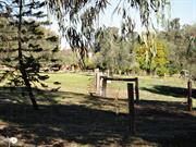
Belhus Estate
Ellens Brook Homestead
Swan
Metropolitan
Constructed from 1832 to 1900
| Type | Status | Date | Documents |
|---|---|---|---|
| Heritage List | Adopted | 30 Aug 2017 | |
| State Register | Registered | 06 Feb 1998 | HCWebsite.Listing+ListingDocument, HCWebsite.Listing+ListingDocument |
| Type | Status | Date | Documents |
|---|---|---|---|
| (no listings) |
| Type | Status | Date | Grading/Management | |
|---|---|---|---|---|
| Category | ||||
| Municipal Inventory | Adopted | 29 Jul 1998 | Exceptional Significance | |
| Classified by the National Trust | Classified {Lscpe} | |||
| Restrictive Covenant | YES | |||
| Register of the National Estate | Permanent | 21 Mar 1978 | ||
| Classified by the National Trust | Classified | 17 Jan 1977 | ||
Individual Building or Group
| Epoch | General | Specific |
|---|---|---|
| Present Use | FARMING\PASTORAL | Homestead |
| Original Use | FARMING\PASTORAL | Homestead |
| Type | General | Specific |
|---|---|---|
| Wall | BRICK | Common Brick |
| Roof | METAL | Corrugated Iron |
| General | Specific |
|---|---|
| DEMOGRAPHIC SETTLEMENT & MOBILITY | Settlements |
This information is provided voluntarily as a public service. The information provided is made available in good faith and is derived from sources believed to be reliable and accurate. However, the information is provided solely on the basis that readers will be responsible for making their own assessment of the matters discussed herein and are advised to verify all relevant representations, statements and information.
Constructed from 1831 to 1910
Henry Bull's Cottage, comprising a two-storey, brick and shingle house, the mill race and mill pond, the grape pickers' quarters, and the lime kiln, has cultural heritage significance for the following reasons: The place demonstrates the early nineteenth century European settlement of the Swan River Colony for agricultural purposes; The place is a representative remnant of the system of land grants and land tenure instituted by the first European inhabitants of the Swan River Colony; the mill race, mill pond and lime kiln are examples of technical achievement at a time of economic struggle during the nineteenth century; The valley containing the house, mill race, mill pond, grape pickers' quarters and lime kiln, together with the bridge over Ellen Brook in the adjacent Public Open Space, constitutes a landscape with aesthetic qualities valued by the community; The mill race, mill pond and lime kiln are important for their potential to reveal information contributing to the methods of milling flour and the burning of lime in the colony during the nineteenth century; The place is important for its association with the Leake and Barrett-Lennard families; and, The place contributes to the community's sense of place by providing a link with the colonial development of the area. The large farm shed to the north-east of the house and the reconstructed mill which were built in 1984-88 are not part of the historic precinct, even though the mill with its faithfully re-constructed wheel is of interest and with the mill race and pond contributes to the overall setting. The mill dam on the adjoining Lot 4 is not included in this assessment; nor is the bridge over Ellen Brook situated in Public Open Space to the south.
The homestead has a two-storey core with a single-storey lean-to at the east and north sides and a two-storied verandah (reconstructed in 1988) along the west (front) elevation. The south elevation has a brick chimney serving fireplaces at ground and first floor levels. The footings are of granite and brick. The walls are of brick burnt on site, Flemish bond to the front, and English bond elsewhere. (The brickwork to the north side lean-to was reconstructed in 1988.) The roof of sheoak shingles, replaced corrugated iron in 1988. The front door leads to a hall with a steep staircase. On each floor there are two small rooms each side of the hall. The ground floor rooms have lath and plaster ceilings, replaced as such in 1987 and the first floor rooms have ripple iron ceilings. Windows are either double casements or pivoted sashes. The lean-to at the east side has a kitchen at the north end and a bathroom at the south end (both fitted out in 1988) and a vestibule between. A toilet building is situated 50 metres or so from the homestead and half way down the slope of the hillock on which the homestead stands. The building is of brick construction with a timber-shingled roof. The toilets were of the removable-pan type and the building still contains two wooden toilet seats side by side. The brickwork of the walls and the toilet seats appear to be original. The shingles of the roof are a modern reconstruction. The workers' quarters is situated adjacent to the old Ellen's Brook Homestead and consists of two main buildings. The first is either the foreman's hut or a kitchen for the complex of workers' huts. The other building is a row of sleeping huts, each separated from its neighbours by about a metre, and having its own roof, but all the huts are united by a common floor and a common but independent roof structure supported by timber posts and struts. A large Cape Lilac Tree once situated about twenty metres from the north-eastern side of the Ellen's Brook homestead and was long a prominent feature of the place. Following a site visit in 2016, the tree has been removed.
The original elements of the place may make this homestead the oldest extant residence in Western Australia. As a building, only the Round House, Fremantle, would be older. It is possible that the toilets date back to the construction of the original homestead on the property in 1831-33, and thus would be associated with Henry Bull and the builder, Richard Edwards. When George Hardey Barrett-Lennard purchased the Ellen's Brook Estate in 1897, he renamed the property Belhus Estate after Belhus Manor, the family seat in Essex, England, and commenced to develop its viticultural potential. Large areas were planted with vines for the production of table grapes, of which he became the first large-scale exporter in Western Australia. It was necessary to employ large numbers of temporary workers during the grape-picking season in mid to late summer, and the existing workers' quarters were built for the purpose of accommodating some of the workers during the season. At the height of vineyard activity the estate employed about twenty grape-pickers and about 120 workers (mainly women) to clean and pack the grapes. When restoration of the group was considered by the present owners in 1988, it was found that much of the timberwork was affected by termite damage. It was found necessary to dismantle the complex and rebuild it. Original materials were used wherever possible, but some recycled timber was introduced. The result is a faithful replication of the original buildings on their original site and gives little hint of being a reconstruction. In 2016, the tree was uprooted as a result from a storm. It was later discovered that the tree was rotten internally.
High
Good
| Owner | Category |
|---|---|
| Mulitplex Constructions Pty Ltd. | Other Private |
This information is provided voluntarily as a public service. The information provided is made available in good faith and is derived from sources believed to be reliable and accurate. However, the information is provided solely on the basis that readers will be responsible for making their own assessment of the matters discussed herein and are advised to verify all relevant representations, statements and information.
West Swan Rd Belhus
Municipal Inventory No: 638. The bridge stands on the site of a ford near Cruse's Mill (Henry Bull's Cottage/Belhus Estate P2536). The MI states it is Lot 30, 12571 West Swan Road, Ellenbrook.
Cruse's Mill, Belhus Estate
MRWA 915
Swan
Metropolitan
Constructed from 1988, Constructed from 1850
| Type | Status | Date | Documents |
|---|---|---|---|
| (no listings) |
| Type | Status | Date | Documents |
|---|---|---|---|
| RHP - Does not warrant assessment | Current | 14 May 2021 |
| Type | Status | Date | Grading/Management | |
|---|---|---|---|---|
| Category | ||||
| Statewide Lge Timber Str Survey | Completed | 11 Dec 1998 | ||
| Municipal Inventory | Adopted | 29 Jul 1998 | Significant | |
| Municipal Inventory | Adopted | 30 Aug 2017 | Category 3 | |
04118 Ellen's Brook Estate Mill Dam and Mill Weir
Currently (1998) some of the timber deck sleepers show termite damage, and some are virtually destroyed.
Historic site
| Epoch | General | Specific |
|---|---|---|
| Present Use | Transport\Communications | Road: Bridge |
| Original Use | Transport\Communications | Road: Bridge |
| Type | General | Specific |
|---|---|---|
| Other | TIMBER | Other Timber |
| General | Specific |
|---|---|
| OCCUPATIONS | Manufacturing & processing |
| DEMOGRAPHIC SETTLEMENT & MOBILITY | Settlements |
This information is provided voluntarily as a public service. The information provided is made available in good faith and is derived from sources believed to be reliable and accurate. However, the information is provided solely on the basis that readers will be responsible for making their own assessment of the matters discussed herein and are advised to verify all relevant representations, statements and information.
Constructed from 1896, Constructed from 1988
Significant as the location of a place used to cross Ellen's Brook since the earliest years of the Colony.
The bridge is of timber, having been rebuilt in 1988, from the previous construction of 1850-51, as a footbridge, narrower than the original. The previous width of the bridge can be seen by the position of the piles and half caps supporting the present deck. The deck is constructed of jarrah railway sleepers.
The site where this bridge stands was used as a ford to cross Ellen's Brook from the earliest years of the colony. (Further downstream the valley sides were too steep to allow carts and other vehicles to pass easily.) A public road was surveyed on the west side of the Swan Valley in the early 1840s and led to this point near Cruse's Mill. However, no bridge was built across Ellen's Brook until 1850-51, when convict labour was made available for public works. At the time the bridge was built, a new road was surveyed and cleared between this point and the northern side of the new Upper Swan Bridge. This road remained a public highway for many years after the West Swan Road was re-routed, and part of it is still a public road (called Cruse Belhus Road).
Low
This information is provided voluntarily as a public service. The information provided is made available in good faith and is derived from sources believed to be reliable and accurate. However, the information is provided solely on the basis that readers will be responsible for making their own assessment of the matters discussed herein and are advised to verify all relevant representations, statements and information.
West Swan Rd Belhus
West Swan Rd and Great Northern Hwy
Swan
Metropolitan
| Type | Status | Date | Documents |
|---|---|---|---|
| (no listings) |
| Type | Status | Date | Documents |
|---|---|---|---|
| (no listings) |
| Type | Status | Date | Grading/Management | |
|---|---|---|---|---|
| Category | ||||
| Aboriginal Heritage Sites Register | Registered | |||
| Register of the National Estate | Interim | 14 May 1991 | ||
Historic Site
| Epoch | General | Specific |
|---|---|---|
| Original Use | PARK\RESERVE | Park\Reserve |
| General | Specific |
|---|---|
| PEOPLE | Aboriginal people |
| PEOPLE | Famous & infamous people |
This information is provided voluntarily as a public service. The information provided is made available in good faith and is derived from sources believed to be reliable and accurate. However, the information is provided solely on the basis that readers will be responsible for making their own assessment of the matters discussed herein and are advised to verify all relevant representations, statements and information.
Lot 37 West Swan Rd Belhus
MI: 544
Swan
Metropolitan
Constructed from 1930
| Type | Status | Date | Documents |
|---|---|---|---|
| (no listings) |
| Type | Status | Date | Documents |
|---|---|---|---|
| (no listings) |
| Type | Status | Date | Grading/Management | |
|---|---|---|---|---|
| Category | ||||
| (no listings) | ||||
Individual Building or Group
| Epoch | General | Specific |
|---|---|---|
| Original Use | INDUSTRIAL\MANUFACTURING | Other |
| Type | General | Specific |
|---|---|---|
| Other | METAL | Other Metal |
| Other | CONCRETE | Other Concrete |
| General | Specific |
|---|---|
| OCCUPATIONS | Grazing, pastoralism & dairying |
| OCCUPATIONS | Manufacturing & processing |
This information is provided voluntarily as a public service. The information provided is made available in good faith and is derived from sources believed to be reliable and accurate. However, the information is provided solely on the basis that readers will be responsible for making their own assessment of the matters discussed herein and are advised to verify all relevant representations, statements and information.
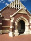
Clayton St Bellevue
Swan
Metropolitan
Constructed from 1909 to 1991
| Type | Status | Date | Documents |
|---|---|---|---|
| Heritage List | YES | 15 Dec 2010 | |
| Heritage List | Adopted | 30 Aug 2017 | |
| State Register | Registered | 20 Oct 2000 | HCWebsite.Listing+ListingDocument, HCWebsite.Listing+ListingDocument |
| Type | Status | Date | Documents |
|---|---|---|---|
| (no listings) |
| Type | Status | Date | Grading/Management | |
|---|---|---|---|---|
| Category | ||||
| Municipal Inventory | Adopted | 10 Jul 1996 | Exceptional Significance | |
| Anglican Church Inventory | YES | 31 Jul 1996 | ||
| Name | Type | Year From | Year To |
|---|---|---|---|
| Brown & Clinch | Architect | - | - |
Individual Building or Group
| Epoch | General | Specific |
|---|---|---|
| Present Use | RELIGIOUS | Church, Cathedral or Chapel |
| Original Use | RELIGIOUS | Church, Cathedral or Chapel |
| Style |
|---|
| Federation Gothic |
| Type | General | Specific |
|---|---|---|
| Roof | METAL | Corrugated Iron |
| Wall | BRICK | Rendered Brick |
| Other | TIMBER | Tongue & Groove |
| Wall | BRICK | Common Brick |
| General | Specific |
|---|---|
| SOCIAL & CIVIC ACTIVITIES | Religion |
| SOCIAL & CIVIC ACTIVITIES | Community services & utilities |
This information is provided voluntarily as a public service. The information provided is made available in good faith and is derived from sources believed to be reliable and accurate. However, the information is provided solely on the basis that readers will be responsible for making their own assessment of the matters discussed herein and are advised to verify all relevant representations, statements and information.
Constructed from 1909
The place is a good example of a simply designed, competently constructed church in the Federation Gothic style. The place demonstrates creativity in design through the restrained application of a range of Gothic revival and arts and crafts devices, including the auditory plan, the Gothic revival proportions and the use of decorative motifs; While there are other churches in Western Australia of similar age, scale and construction materials, there are no direct comparisons with Church of the Good Shepherd in terms of its architectural detailing; The place is associated with pastoralist, explorer and politician, Edward Robinson who donated the land and made significant contributions toward the construction of the church and with his wife, Sophia, in whose memory the Church was built; The place is representative of the establishment of churches in newly subdivided areas such as Bellevue on the outskirts of Midland Junction in the early 1900s; and The place is highly valued by the Anglican community of Bellevue for its continued role as a place of worship from 1909 to 1999, which has contributed to the community’s sense of place. The toilet block to the south of the church and the parish centre west of the church are considered to have low significance.
A single-storey brick building with a custom orb Colourbond roof in the Federation Gothic style. Church of the Good Shepherd is a small, simply designed building, with a use of embellishments such as rendered moldings in the external walls and the timber tracery inserts to the window.
Built for the Anglican church by Edward Robinson after his wife's death in 1909 as a memorial to her. In 2000, the place ceased operating as an Anglican Church. The church currently operates as the non-denominational Swan Christian Fellowship.
Good
Good
| Name | Type | Year From | Year To |
|---|---|---|---|
| Brown & Clinch | Architect | 1909 | - |
| Owner | Category |
|---|---|
| Swan Christian Fellowship (Christian Brethren Inc) | Church Property |
This information is provided voluntarily as a public service. The information provided is made available in good faith and is derived from sources believed to be reliable and accurate. However, the information is provided solely on the basis that readers will be responsible for making their own assessment of the matters discussed herein and are advised to verify all relevant representations, statements and information.