Local Government
Bayswater
Region
Metropolitan
Intersection of Coode & Beaufort Sts Bayswater
& Rychens Dairies
Brownes, Meakins (later Mounseys then Beales)
Bayswater
Metropolitan
| Type | Status | Date | Documents |
|---|---|---|---|
| (no listings) |
| Type | Status | Date | Documents |
|---|---|---|---|
| (no listings) |
| Type | Status | Date | Grading/Management | |
|---|---|---|---|---|
| Category | ||||
| (no listings) | ||||
Historic Site
| Epoch | General | Specific |
|---|---|---|
| Present Use | INDUSTRIAL\MANUFACTURING | Dairy, Butter or Cheese Factory |
| Original Use | INDUSTRIAL\MANUFACTURING | Dairy, Butter or Cheese Factory |
This information is provided voluntarily as a public service. The information provided is made available in good faith and is derived from sources believed to be reliable and accurate. However, the information is provided solely on the basis that readers will be responsible for making their own assessment of the matters discussed herein and are advised to verify all relevant representations, statements and information.
Cnr King William & Hamilton Sts Bayswater
Bayswater
Metropolitan
Constructed from 1928
| Type | Status | Date | Documents |
|---|---|---|---|
| Heritage List | Adopted | 25 Feb 2020 |
| Type | Status | Date | Documents |
|---|---|---|---|
| (no listings) |
| Type | Status | Date | Grading/Management | |
|---|---|---|---|---|
| Category | ||||
| Municipal Inventory | Adopted | 24 Feb 1998 | Classification 5 | |
| Local Heritage Survey | Adopted | 25 Feb 2020 | Classification 3 | |
Urban Park
| Epoch | General | Specific |
|---|---|---|
| Present Use | PARK\RESERVE | Park\Reserve |
| Original Use | PARK\RESERVE | Park\Reserve |
| General | Specific |
|---|---|
| SOCIAL & CIVIC ACTIVITIES | Sport, recreation & entertainment |
This information is provided voluntarily as a public service. The information provided is made available in good faith and is derived from sources believed to be reliable and accurate. However, the information is provided solely on the basis that readers will be responsible for making their own assessment of the matters discussed herein and are advised to verify all relevant representations, statements and information.
Constructed from 1928
This place is representative of civic functions within Bayswater and has an historic association with the development of the Bayswater Townsite.
A public park consisting mainly of a large levelled lawn area suitable for games and other activities. This area is achieved on what would originally have been a sloping site by the construction of steep banks on two sides. These banks are also grassed and surmounted by the row of trees which surrounds the whole area.
The land was resumed in 1928 and improvements have been carried out progressively. This historic park near the centre of Bayswater was the first public area resumed by the Roads Board. It had formerly been the site of Chue Hing's garden and then a small mixed farm. During the late 1920s, when an effort was being made to upgrade the business district, it was decided that a farm, which was not particularly presentable, located within the town centre created the wrong impression. Robert McLeish, President of the Businessmen's Association, led the campaign to have it taken over for public purposes. In 1928, it was resumed, improved and eventually named Whatley Gardens. This became the home ground of the Women's Hockey Club during the 1930s. During the 1960s when modern facilities were being developed in the district, it was chosen as a site for the Senior Citizens Centre and the Bayswater Library. The name was changed in honour of Bert Wright, a long standing Shire Council member and well known hardware store proprietor. The presence of this park and Halliday Park so close to the centre of Bayswater reminds us of the rural locations into which Swan Location U was originally subdivided. Had these large areas of land not remained farms until well into the twentieth century, they would not now be parklands.
Integrity - High Authenticity - High
Good
This information is provided voluntarily as a public service. The information provided is made available in good faith and is derived from sources believed to be reliable and accurate. However, the information is provided solely on the basis that readers will be responsible for making their own assessment of the matters discussed herein and are advised to verify all relevant representations, statements and information.
King William St Bayswater
Eric Singleton Bird Sanctuary
Bayswater
Metropolitan
Constructed from 1978
| Type | Status | Date | Documents |
|---|---|---|---|
| Heritage List | Adopted | 25 Feb 2020 |
| Type | Status | Date | Documents |
|---|---|---|---|
| (no listings) |
| Type | Status | Date | Grading/Management | |
|---|---|---|---|---|
| Category | ||||
| Local Heritage Survey | Adopted | 25 Feb 2020 | Classification 2 | |
| Municipal Inventory | Adopted | 24 Feb 1998 | ||
11872 Riverfront
| Library Id | Title | Medium | Year Of Publication |
|---|---|---|---|
| 9530 | Swan and Helena rivers regional recreational path development plan. | Report | 2009 |
| 7196 | Conservation plan for colonial sites on the City of Bayswater foreshore. CONFIDENTIAL | Heritage Study {Cons'n Plan} | 2004 |
| 9531 | Swan and Helena rivers management framework: heritage audit and statement of significance, final report 26 February 2009. | Heritage Study {Other} | 2009 |
Landscape
| Epoch | General | Specific |
|---|---|---|
| Present Use | OTHER | Other |
| Original Use | OTHER | Other |
| General | Specific |
|---|---|
| DEMOGRAPHIC SETTLEMENT & MOBILITY | Settlements |
This information is provided voluntarily as a public service. The information provided is made available in good faith and is derived from sources believed to be reliable and accurate. However, the information is provided solely on the basis that readers will be responsible for making their own assessment of the matters discussed herein and are advised to verify all relevant representations, statements and information.
Constructed from 1976
This place has environmental significance for the region, providing an important habitat for many bird species. It has historic value for its association with Eric Singleton.
A natural lake and marsh area with man-made improvements.
This four hectare site was set aside in 1976 as a haven for water birds exposed to the disruptions of recreational activities on the river, such as speed boats and water skiing. The Sanctuary is recognised by the Royal Australian Ornithological Union and some 74 species of birds have been recorded here. Much success has also been achieved with the use of artificial nesting boxes.
Integrity - Moderate (natural feature has been modified) Authenticity - High
Good
| Ref Number | Description |
|---|---|
| 57 | Local Heritage Survey Number |
This information is provided voluntarily as a public service. The information provided is made available in good faith and is derived from sources believed to be reliable and accurate. However, the information is provided solely on the basis that readers will be responsible for making their own assessment of the matters discussed herein and are advised to verify all relevant representations, statements and information.
10-12 King William St Bayswater
King William Street Liquor Store & Deli
Wright's Hardware Store
Bayswater
Metropolitan
Constructed from 1906
| Type | Status | Date | Documents |
|---|---|---|---|
| Heritage List | Adopted | 25 Feb 2020 |
| Type | Status | Date | Documents |
|---|---|---|---|
| RHP - Does not warrant assessment | Current | 09 May 2003 |
| Type | Status | Date | Grading/Management | |
|---|---|---|---|---|
| Category | ||||
| Classified by the National Trust | YES | 21 Jul 1997 | ||
| Municipal Inventory | Adopted | 24 Feb 1998 | Classification 2 | |
| Local Heritage Survey | Adopted | 25 Feb 2020 | Classification 2 | |
10977 Bayswater Business District
Individual Building or Group
| Epoch | General | Specific |
|---|---|---|
| Original Use | COMMERCIAL | Shop\Retail Store {single} |
| Present Use | COMMERCIAL | Shop\Retail Store {single} |
| Type | General | Specific |
|---|---|---|
| Wall | METAL | Corrugated Iron |
| Roof | METAL | Corrugated Iron |
| General | Specific |
|---|---|
| OCCUPATIONS | Commercial & service industries |
This information is provided voluntarily as a public service. The information provided is made available in good faith and is derived from sources believed to be reliable and accurate. However, the information is provided solely on the basis that readers will be responsible for making their own assessment of the matters discussed herein and are advised to verify all relevant representations, statements and information.
Constructed from 1905 to 1908
This shop is significant as an elaborate corrugated iron structure built at a time when corrugated iron as a building material was used mainly for worker's cottages and self-built houses. This is one of the last corrugated iron structures in Bayswater and certainly the largest. It is also a relic of the time when the storekeeper's family and staff lived on the premises, as indicated by the row of bedrooms upstairs. The store was a landmark in the development of the Bayswater business district on the south side of the railway line from 1905 onwards. Previously, commercial premises, including McLeish's first and more modest shop, had been to the north of the line. Robert McLeish, who built the store, was a community leader in Bayswater from just after the turn of the century well into the 1930s. He built stores in Mt Lawley and also Kellerberrin but, his prominence was limited to Bayswater, as tended to be the case at a time when communities were largely self sufficient. The store has townscape value, as it is a centrepiece of the old Bayswater business district and thus vital to the townscape. Along with other stores, the King William Liquor Store is evidence of the old style of commercial architecture and therefore a research and education resource for architectural historians. Finally, the advent of substantial stores like the King William Liquor Store was evidence of the development of the Bayswater settlement beyond a pioneer community and can be seen as part of the trend exemplified by the Drill Hall, brick churches and additions to the school, all of which occurred around this time. It demonstrates early suburban growth, especially in a semi-rural context, as McLeish's ran a grain and feed store on the premises as well as a butcher and grocery store. Later, the grain store was moved to new premises across King William Street.
This large two-storey timber framed building is clad throughout with a corrugated iron hip roof without the eaves overhang. A ground floor contains commercial premises facing onto King William Street with cast iron facings and modernised shop windows under a tied cantilever canopy. The upper floor containing residential type accommodation features large double hung wooden sash windows between a pair of doors opening onto the canopy. All these openings have louvred wooden shutters which are probably a recent addition.
This building is one of the most significant remaining in Bayswater. It was the first major commercial building to be constructed to the south of the railway line and in that sense was the pioneer of the present shopping centre. It is idiosyncratic in being built of corrugated iron, usually associated with modest houses, rather than shops. This was the time when Bayswater was in a state of transition from the corrugated iron phase to brick shops and public buildings and so the store is also one of the few survivors of that early building style. However, it was one of several larger structures from the period 1905-1908 which was something of a building boom in the district. The association of the store with Robert McLeish is also important. The McLeish family were of South Australian origin and originally built a store on the north of the line. This was the first butcher shop in Bayswater which also sold vegetables. When it was burnt down the more substantial store in King William Street was constructed and was run by the whole family, with several staff who lived upstairs. Robert McLeish was a particularly significant individual in Bayswater history. He did not sit on the Roads Board, considering that business and politics did not mix. He was, however, a powerful force in the community, galvanising and channelling public opinion. He was described as "the power behind the Board" and was also the Chairman of the Businessmen's Association in the 1920s. Unlike many local people who "made good", he built a large house in Bayswater and continued to participate in local events as did his children. In later years the store was well known as the home of Wright's Grocery Store.
This information is provided voluntarily as a public service. The information provided is made available in good faith and is derived from sources believed to be reliable and accurate. However, the information is provided solely on the basis that readers will be responsible for making their own assessment of the matters discussed herein and are advised to verify all relevant representations, statements and information.
Constructed from 1906
This place is signficant to the development of the Bayswater townsite, being the first commercial building to be constructed in the area. It is one of the few remaining examples of a commercial building constructed in corrugated iron. The place has historic value for its association with the Mcleishs, a family who were influential within Bayswater.
This large two storey timber framed building is clad throughout with corrugated iron under a corrugated iron hip roof without the eaves overhang. A ground floor contains commercial premises facing onto King William Street with cast iron facings and modernised shop windows under a tied cantilever canopy. The upper floor containing residential type accommodation features large double hung wooden sash windows between a pair of doors opening onto the canopy. All these openings have louvred wooden shutters which are probably a recent addition.
This is one of the most significant buildings remaining in Bayswater. It was the first major commercial building to be constructed to the south of the railway line and in that sense was the pioneer of the present shopping area. It is idiosyncratic in being built of corrugated iron, usually associated with modest houses, rather than shops. This was the time when Bayswater was in a state of transition from the corrugated iron phase to brick shops and public buildings and so the store is also one of the few survivors of that early building style. However, it was one of several larger structures from the period 1905-1908 which was something of a building boom in the district, primarily as a result of the gold rushes of the 1890s as well as impetus provided by its proximity to the Fremantle to Guildford Railway in the 1880s. The association of the store with Robert McLeish is also important. The McLeish family were of South Australian origin and originally built a store on the north of the line. This was the first butcher shop in Bayswater which also sold vegetables. When it was burnt down the more substantial store in King William Street was constructed and was run by the whole family, with several staff who lived upstairs. Robert McLeish was a particularly significant individual in Bayswater history. He did not sit on the Roads Board, considering that business and politics did not mix. However, he was a powerful force in the community, galvanising and channelling public opinion. He was described as "the power behind the Board" and was also the Chairman of the Businessmen's Association in the 1920s. Unlike many local people who "made good", he built a large house in Bayswater and continued to participate in local events as did his children. In later years the store was well known as the home of Wright's Grocery Store.
Integrity - Moderate (modified) Authenticity - Moderate
Good
| Ref Number | Description |
|---|---|
| 50 | Local Heritage Survey Number |
This information is provided voluntarily as a public service. The information provided is made available in good faith and is derived from sources believed to be reliable and accurate. However, the information is provided solely on the basis that readers will be responsible for making their own assessment of the matters discussed herein and are advised to verify all relevant representations, statements and information.
11 King William St Bayswater
Oro Restaurant
Bayswater
Metropolitan
Constructed from 1917
| Type | Status | Date | Documents |
|---|---|---|---|
| Heritage List | Adopted | 25 Feb 2020 |
| Type | Status | Date | Documents |
|---|---|---|---|
| (no listings) |
| Type | Status | Date | Grading/Management | |
|---|---|---|---|---|
| Category | ||||
| Municipal Inventory | Adopted | 24 Feb 1998 | Classification 3 | |
| Local Heritage Survey | Adopted | 25 Feb 2020 | Classification 3 | |
10977 Bayswater Business District
Individual Building or Group
| Epoch | General | Specific |
|---|---|---|
| Present Use | COMMERCIAL | Restaurant |
| Original Use | COMMERCIAL | Shop\Retail Store {single} |
| Type | General | Specific |
|---|---|---|
| Wall | BRICK | Common Brick |
| General | Specific |
|---|---|
| OCCUPATIONS | Commercial & service industries |
This information is provided voluntarily as a public service. The information provided is made available in good faith and is derived from sources believed to be reliable and accurate. However, the information is provided solely on the basis that readers will be responsible for making their own assessment of the matters discussed herein and are advised to verify all relevant representations, statements and information.
Constructed from 1917
This place is a representative example of an early shop in the area and has historic value for its association with the development of the Bayswater townsite. The place makes a significant contribution to the townscape. The place has historic value for its association with the A A West and the McLeishs'.
This single storey brick shop with a glazed opening to King William Street has now been modernised. It has double hung wooden sash frame windows. The end of the corrugated iron gable roof is concealed at the front by a parapet with a triangular pediment. French doors open from the side of the shop onto a small courtyard (now used for "al fresco" dining) originally part of the front garden of the neighbouring cottage.
The origin of this store is obscure, but the land was purchased in 1905 by Alfred Archibald West, a prominent citizen, Roads Board Chairman and master plumber. The building was apparently constructed as a produce store which indicates why it is not of particularly elegant or decorative design. The Post Office Directory indicates that it was built during the Great War, being run during the 1920s by James McLeish.
Integrity - High Authenticity - High
Good
| Ref Number | Description |
|---|---|
| 50 | Local Heritage Survey Number |
This information is provided voluntarily as a public service. The information provided is made available in good faith and is derived from sources believed to be reliable and accurate. However, the information is provided solely on the basis that readers will be responsible for making their own assessment of the matters discussed herein and are advised to verify all relevant representations, statements and information.
114 King William St Bayswater
Bayswater Historical Society
Leighton
Bayswater
Metropolitan
Constructed from 1893
| Type | Status | Date | Documents |
|---|---|---|---|
| Heritage List | Adopted | 25 Feb 2020 | |
| State Register | Registered | 23 Jun 2000 | HCWebsite.Listing+ListingDocument, HCWebsite.Listing+ListingDocument |
| Type | Status | Date | Documents |
|---|---|---|---|
| (no listings) |
| Type | Status | Date | Grading/Management | |
|---|---|---|---|---|
| Category | ||||
| Classified by the National Trust | YES | 02 Mar 1982 | ||
| Register of the National Estate | Nominated | 30 Apr 1982 | ||
| Register of the National Estate | Indicative Place | |||
| Classified by the National Trust | Classified | 02 Mar 1982 | ||
| Municipal Inventory | Adopted | 24 Feb 1998 | Classification 1 | |
| Local Heritage Survey | Adopted | 25 Feb 2020 | Classification 1 | |
| Name | Type | Year From | Year To |
|---|---|---|---|
| H T Halliday | Architect | - | - |
| Library Id | Title | Medium | Year Of Publication |
|---|---|---|---|
| 7196 | Conservation plan for colonial sites on the City of Bayswater foreshore. CONFIDENTIAL | Heritage Study {Cons'n Plan} | 2004 |
Individual Building or Group
| Epoch | General | Specific |
|---|---|---|
| Present Use | EDUCATIONAL | Museum |
| Original Use | RESIDENTIAL | Single storey residence |
| Style |
|---|
| Federation Queen Anne |
| Type | General | Specific |
|---|---|---|
| Roof | METAL | Corrugated Iron |
| Wall | BRICK | Common Brick |
| General | Specific |
|---|---|
| DEMOGRAPHIC SETTLEMENT & MOBILITY | Settlements |
This information is provided voluntarily as a public service. The information provided is made available in good faith and is derived from sources believed to be reliable and accurate. However, the information is provided solely on the basis that readers will be responsible for making their own assessment of the matters discussed herein and are advised to verify all relevant representations, statements and information.
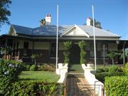
A large stately house externally, retaining the architectural character of the period and association with the one family and with the local council in its early days.
A single story house, originally built in the 1880s and added to over a period of time to form a large family homogeneous house in fairly typical style for the period, constructed of brickwork with corrugated iron roof and with prominent chimneys and a wide encircling verandah.
Part of the original house was used by the Bayswater Road Board for their early meetings and the ownership of the house has remained in the one family, the builder of the house, Mr H. T. Halliday, being the first chairman of the Road Board.
Externally, the building as a whole is intact except for new roof sheeting and rafters to the verandahs being altered to some extent, but generally in keeping with the rest of the house.
This information is provided voluntarily as a public service. The information provided is made available in good faith and is derived from sources believed to be reliable and accurate. However, the information is provided solely on the basis that readers will be responsible for making their own assessment of the matters discussed herein and are advised to verify all relevant representations, statements and information.
Constructed from 1892
This place is significant for its association with the Halliday family, who were influential to the development of Bayswater. It is a representative example of the Federation Queen Anne architectural style. This landmark building has important social and cultural associations, which continues today through its use by the Bayswater Historical Society.
Halliday House is a large well constructed brick house with a double hipped roof over a summetrical square plan and with a small, half timbered gable and ventilator over the central front entrance. A separate low pitched iron roof supported on full length timber posts extends across the front verandahs from the corner bay and continues down the right hand (northern) side verandah. The external brick walls are tuck-pointed up to the mid-level of the double hung sash windows with cement render above this height and on the window sills. The roof is crowed at the ridge corners with prominent brick chimneys each with two terracotta pots and there is a flight of six cement steps up to the entrance from the central cement pathway though a well kept and extensively formal garden. Halliday House is an unusually elaborate residence for this area. The interior includes a decorative niched oval dome housing the chandelier and ornate masonry in the passageways. The front boundary is marked by a decorative wrought iron fence and gate decorated with a clipped hedge.
The land on which "Leighton" is built was originally acquired from James Alexander Halliday by Henry Halliday in 1894. However, it would appear that Halliday started building the house in 1892 and, with his wife Edith, took up residence in 1893. During the early 1890s, a small settlement on the Bayswater estate was growing and the Hallidays, though not one of the first land purchasers of 1885, were part of this development. Thus, the house has a connection with the pioneering phase of Bayswater. Most houses in the 1880s and 1890s were hastily built from corrugated iron but "Leighton House" was constructed in a much more substantial manner. One of the most elaborate houses in the district, it reflects not only the Halliday's resources, but also their faith in the future of Bayswater. It was a 'dream home' of the time. It is also significant as a self built house of an early master builder. The Bapitist congregation was inaugurated at "Leighton" in 1895. Those in attendance included the Halliday family and four others. Until the building of a Baptist Church, it no doubt continued to provide a meeting place for the small congregation. In recent years, the house has been restored and was transferred to the Bayswater Historical Society who maintain the house as a museum and headquarters of the historical society.
Integrity - High Authenticity - High
Good
| Ref Number | Description |
|---|---|
| 56 | Local Heritage Survey Number |
This information is provided voluntarily as a public service. The information provided is made available in good faith and is derived from sources believed to be reliable and accurate. However, the information is provided solely on the basis that readers will be responsible for making their own assessment of the matters discussed herein and are advised to verify all relevant representations, statements and information.
1-3 King William St Bayswater
Cnr Whatley Cres
Bayswater
Metropolitan
Constructed from 1905
| Type | Status | Date | Documents |
|---|---|---|---|
| Heritage List | Adopted | 25 Feb 2020 |
| Type | Status | Date | Documents |
|---|---|---|---|
| (no listings) |
| Type | Status | Date | Grading/Management | |
|---|---|---|---|---|
| Category | ||||
| Municipal Inventory | Adopted | 24 Feb 1998 | ||
| Local Heritage Survey | Adopted | 25 Feb 2020 | Classification 3 | |
10977 Bayswater Business District
Individual Building or Group
| Epoch | General | Specific |
|---|---|---|
| Present Use | COMMERCIAL | Shop\Retail Store {single} |
| Original Use | COMMERCIAL | Shop\Retail Store {single} |
| Type | General | Specific |
|---|---|---|
| Wall | BRICK | Common Brick |
| General | Specific |
|---|---|
| OCCUPATIONS | Commercial & service industries |
This information is provided voluntarily as a public service. The information provided is made available in good faith and is derived from sources believed to be reliable and accurate. However, the information is provided solely on the basis that readers will be responsible for making their own assessment of the matters discussed herein and are advised to verify all relevant representations, statements and information.
Constructed from 1905
This place is a representative example of an early shop in the area and has historic value for its association with the development of the Bayswater townsite. The place makes a significant contribution to the townscape. It has associations with a number of significant families within Bayswater - Halliday, Campbell, McLeish and Inglis.
Distinctive brick corner shop with Edwardian parapet detail and tied cantilever awning, originally with a pressed metal ceiling which has been modified in recent years, together with the interior ceiling. The original corner doorway has been closed off and a tiled dado treatment carried across the facade. A new entrance to the building has been created onto King William Street. The building is located on a lot together with the office (real estate) facing King William Street and the shop (newsagency) facing Whatley Crescent. The corner building has the most significance of the three, whilst the other two retain some level of significance, it is considered to be less than that of the corner building.
This store is of considerable significance in the growth of the Bayswater business district. The first business premises of any size erected on the railway frontage, it was architect designed and constructed by Henry Halliday in 1905 for a Mrs Webster. There was a sequel to the construction of the building when it was found to encroach marginally on to King William Street. The Roads Board eventually came to an arrangement whereby Mrs Webster paid a peppercorn rental each year for the privilege of occupying the road reserve. The store had some interesting tenants. George Campbell ran his grocery store there before opening his own shop on the corner of Whatley Crescent and Hamilton Street. Two of the McLeish girls ran it themselves as a grocery store during the Second World War. In the late 1950s, Jack Percival Inglis, whose chemist shop was situated in another store further up Whatley Crescent, moved into the former grocer shop, eventually extending the premises into the adjoining shop. Inglis Chemist was something of an institution in Bayswater.
Integrity - Low (substantially modified) Authenticity - Low (compromised)
Good
| Name | Type | Year From | Year To |
|---|---|---|---|
| Henry Halliday | Architect | 1905 | - |
| Ref Number | Description |
|---|---|
| 48 | Local Heritage Survey Number |
This information is provided voluntarily as a public service. The information provided is made available in good faith and is derived from sources believed to be reliable and accurate. However, the information is provided solely on the basis that readers will be responsible for making their own assessment of the matters discussed herein and are advised to verify all relevant representations, statements and information.
13A & B King William St Bayswater
Real Estate Agent & Gift Shop
Bayswater
Metropolitan
Constructed from 1919 to 1922
| Type | Status | Date | Documents |
|---|---|---|---|
| Heritage List | Adopted | 25 Feb 2020 |
| Type | Status | Date | Documents |
|---|---|---|---|
| (no listings) |
| Type | Status | Date | Grading/Management | |
|---|---|---|---|---|
| Category | ||||
| Municipal Inventory | Adopted | 24 Feb 1998 | Classification 2 | |
| Local Heritage Survey | Adopted | 25 Feb 2020 | Classification 2 | |
10977 Bayswater Business District
Individual Building or Group
| Epoch | General | Specific |
|---|---|---|
| Present Use | COMMERCIAL | Shop\Retail Store {single} |
| Original Use | SOCIAL\RECREATIONAL | Other Sports Building |
| Type | General | Specific |
|---|---|---|
| Wall | BRICK | Common Brick |
| General | Specific |
|---|---|
| SOCIAL & CIVIC ACTIVITIES | Sport, recreation & entertainment |
This information is provided voluntarily as a public service. The information provided is made available in good faith and is derived from sources believed to be reliable and accurate. However, the information is provided solely on the basis that readers will be responsible for making their own assessment of the matters discussed herein and are advised to verify all relevant representations, statements and information.
Constructed from 1922, Constructed from 1919
This place is a representative example of an early shop in the area and has historic value for its association with the development of the Bayswater townsite. The place makes a significant contribution to the townscape. The place has historic value for its association with the Marshall family.
The building consists of two small shops of brick construction with a stripped classical parapet over traditional glass shop fronts. There are glazed panel doors to each as well as a central door leading to the rear of the premises. The shop fronts feature a blue glazed tile facing below the shop windows and on the support pillars. These tiles feature a pattern of checkerboard and ornamental tiles as a decorative feature on each panel.
The first part of this building, which was a small billiard saloon, was opened by Jack Smart in 1919 and was situated some 9 metres from King William Street, In 1921, the Marshall family moved to Bayswater from the goldfields where Robert Marshall Senior had previously run a billiard saloon. He acquired Smart's saloon which then consisted of two tables, upgraded it to five tables and also ran a hairdressing business in a small shed at the back. About 1922, he built two stores on the vacant land at the front of the block, with a passage leading back to the billiard saloon. Bob Marshall Junior recalls that it was planned to build a two storey shop similar to Emberson's butcher shop next door, but as the young Bob Marshall was prone to sleep walking it was decided to build single storey shops instead. These were then used as hair dressing salons, one for men and one for women. Bob Marshall Jnr remembers playing marbles under a large Moreton Bay fig tree in front of the building and being called to help lather the clients for shaves when business was brisk on a Saturday morning. He received his early billiards training in the saloon standing on the chair to take shots and went on to become an international champion. After the War, Bob Marshall Jnr. decided to turn the premises into a modern dry cleaning business.
Integrity - Low Authenticity - Low
Fair
| Ref Number | Description |
|---|---|
| 52 | Local Heritage Survey Number |
This information is provided voluntarily as a public service. The information provided is made available in good faith and is derived from sources believed to be reliable and accurate. However, the information is provided solely on the basis that readers will be responsible for making their own assessment of the matters discussed herein and are advised to verify all relevant representations, statements and information.
14 King William St Bayswater
Bayswater
Metropolitan
Constructed from 1895
| Type | Status | Date | Documents |
|---|---|---|---|
| Heritage List | Adopted | 25 Feb 2020 |
| Type | Status | Date | Documents |
|---|---|---|---|
| (no listings) |
| Type | Status | Date | Grading/Management | |
|---|---|---|---|---|
| Category | ||||
| Local Heritage Survey | Adopted | 25 Feb 2020 | Classification 2 | |
| Municipal Inventory | Adopted | 24 Feb 1998 | Classification 2 | |
10977 Bayswater Business District
Individual Building or Group
| Epoch | General | Specific |
|---|---|---|
| Present Use | Transport\Communications | Comms: Post or Telegraph Office |
| Original Use | Transport\Communications | Comms: Post or Telegraph Office |
| Type | General | Specific |
|---|---|---|
| Roof | METAL | Corrugated Iron |
| Wall | BRICK | Common Brick |
| General | Specific |
|---|---|
| TRANSPORT & COMMUNICATIONS | Mail services |
This information is provided voluntarily as a public service. The information provided is made available in good faith and is derived from sources believed to be reliable and accurate. However, the information is provided solely on the basis that readers will be responsible for making their own assessment of the matters discussed herein and are advised to verify all relevant representations, statements and information.
Constructed from 1895
This place is a representative example of an early building in the area and has historic value for its association with the development of the Bayswater townsite, making a significant contribution to the townscape.
South West portion part of the original building. Originally a square brick structure with "hipped" pyramid roof of corrugated iron and central brick chimney. Various additions in differing styles have been made over the years in the same basic materials.
Bayswater acquired a Receiving Office in 1895, with Mrs Smeed as the first Post Mistress. It was upgraded to a Post anad Telegraph office in 1898. Since the Receiving Office was listed as on the corner of Murray and King William Street, it appears that the original building was the Receiving Office. The inadequacy of the accommodation was a sore point especially from the late 1920s when an effort was being made to upgrade the whole town centre. A major, if unsympathetic, improvement was finally made in 1935 at a cost of 500 pounds, but the Post War increases in population once more rendered it obsolete and the latest renovation took place in 1959.
Integrity - Low (extensively modified) Authenticity - Low (compromised)
Good
| Ref Number | Description |
|---|---|
| 53 | Local Heritage Survey Number |
This information is provided voluntarily as a public service. The information provided is made available in good faith and is derived from sources believed to be reliable and accurate. However, the information is provided solely on the basis that readers will be responsible for making their own assessment of the matters discussed herein and are advised to verify all relevant representations, statements and information.
15 King William St Bayswater
King William Quality Meats
Bayswater
Metropolitan
Constructed from 1908
| Type | Status | Date | Documents |
|---|---|---|---|
| Heritage List | Adopted | 25 Feb 2020 |
| Type | Status | Date | Documents |
|---|---|---|---|
| (no listings) |
| Type | Status | Date | Grading/Management | |
|---|---|---|---|---|
| Category | ||||
| Local Heritage Survey | Adopted | 25 Feb 2020 | Classification 2 | |
| Municipal Inventory | Adopted | 24 Feb 1998 | Classification 2 | |
10977 Bayswater Business District
Individual Building or Group
| Epoch | General | Specific |
|---|---|---|
| Original Use | COMMERCIAL | Shop\Retail Store {single} |
| Present Use | COMMERCIAL | Shop\Retail Store {single} |
| Type | General | Specific |
|---|---|---|
| Wall | BRICK | Common Brick |
| General | Specific |
|---|---|
| OCCUPATIONS | Commercial & service industries |
This information is provided voluntarily as a public service. The information provided is made available in good faith and is derived from sources believed to be reliable and accurate. However, the information is provided solely on the basis that readers will be responsible for making their own assessment of the matters discussed herein and are advised to verify all relevant representations, statements and information.
Constructed from 1908
This place is a representative example of an early shop in the area and has historic value for its association with the development of the Bayswater townsite. The place makes a significant contribution to the townscape. The place has historic value for its association with the Embersons'.
This two storey small shop with premises above is constructed in brick with a prominent decorative Victorian style parapet surmounting the front. The plate glass display window and glazed doorway are surrounded below dado level with white glazed tiles with black trim. The asymmetrical window treatment of the upper floor is unusual with two double hung wood sash windows offset to one side and covered by an awning of recent design.
This shop was built in c.1908 by the Emberson Bros. Walter Emberson began as a butcher with McLeish's on the other side of King William Street before setting up in business himself. Originally the staff used to sleep upstairs so as to be awake early enough for the morning's delivery. The shop has been a butcher shop for the whole of its long history.
Integrity - High Authenticity - High
Good
| Ref Number | Description |
|---|---|
| 54 | Local Heritage Survey Number |
This information is provided voluntarily as a public service. The information provided is made available in good faith and is derived from sources believed to be reliable and accurate. However, the information is provided solely on the basis that readers will be responsible for making their own assessment of the matters discussed herein and are advised to verify all relevant representations, statements and information.
59 King William St Bayswater
Bayswater
Metropolitan
Constructed from 1905
| Type | Status | Date | Documents |
|---|---|---|---|
| (no listings) |
| Type | Status | Date | Documents |
|---|---|---|---|
| (no listings) |
| Type | Status | Date | Grading/Management | |
|---|---|---|---|---|
| Category | ||||
| (no listings) | ||||
Individual Building or Group
| Epoch | General | Specific |
|---|---|---|
| Original Use | RESIDENTIAL | Single storey residence |
| Present Use | RESIDENTIAL | Single storey residence |
| Type | General | Specific |
|---|---|---|
| Wall | TIMBER | Weatherboard |
| Roof | METAL | Corrugated Iron |
| General | Specific |
|---|---|
| DEMOGRAPHIC SETTLEMENT & MOBILITY | Settlements |
This information is provided voluntarily as a public service. The information provided is made available in good faith and is derived from sources believed to be reliable and accurate. However, the information is provided solely on the basis that readers will be responsible for making their own assessment of the matters discussed herein and are advised to verify all relevant representations, statements and information.
9 King William St Bayswater
Bayswater Cottage Antiques
Bayswater
Metropolitan
Constructed from 1905
| Type | Status | Date | Documents |
|---|---|---|---|
| Heritage List | Adopted | 25 Feb 2020 |
| Type | Status | Date | Documents |
|---|---|---|---|
| (no listings) |
| Type | Status | Date | Grading/Management | |
|---|---|---|---|---|
| Category | ||||
| Local Heritage Survey | Adopted | 25 Feb 2020 | Classification 3 | |
| Municipal Inventory | Adopted | 24 Feb 1998 | Classification 4 | |
10977 Bayswater Business District
Individual Building or Group
| Epoch | General | Specific |
|---|---|---|
| Original Use | RESIDENTIAL | Other |
| Present Use | COMMERCIAL | Shop\Retail Store {single} |
| Type | General | Specific |
|---|---|---|
| Wall | BRICK | Common Brick |
| Roof | METAL | Corrugated Iron |
| General | Specific |
|---|---|
| DEMOGRAPHIC SETTLEMENT & MOBILITY | Settlements |
This information is provided voluntarily as a public service. The information provided is made available in good faith and is derived from sources believed to be reliable and accurate. However, the information is provided solely on the basis that readers will be responsible for making their own assessment of the matters discussed herein and are advised to verify all relevant representations, statements and information.
Constructed from 1905
The place is representative of early residential development within the Bayswater townsite and was part of the Hamilton Estate. It has historic value for its association with the Halliday family, who were influential members of the Bayswater community. It is representative of the speculative building that occurred within Bayswater during the 1904 - 1907 building boom.
Brick cottage with corrugated iron hip roof and projecting gable front with cross ties and turned wooden finials. Timber steps lead up to small front verandah under a bull nose corrugated iron roof. This has now been glazed in to form a shopfront and the original front wall and doorway removed.
This is the remaining house of a pair built on land acquired by Henry Halliday in 1905, on the sale of the Hamilton Estate. It can be deduced that Halliday built these as speculative or rental properties. He also owned properties a short distance further down King William Street on which were erected three more houses similar in appearance, next to the butcher shop. These houses, together with the shop at the corner of King William Street, all Halliday works, indicate that he was both an investor/builder in his own right and also doing well out of the stepped up activity in the district. All are important to preserve both as the earliest known buildings in or near the business district and known works of Halliday.
Integrity - Low (substantially modified) Authenticity - Moderate (compromised)
Good
| Ref Number | Description |
|---|---|
| 49 | Local Heritage Survey Number |
This information is provided voluntarily as a public service. The information provided is made available in good faith and is derived from sources believed to be reliable and accurate. However, the information is provided solely on the basis that readers will be responsible for making their own assessment of the matters discussed herein and are advised to verify all relevant representations, statements and information.
End of King William St Bayswater
Bayswater
Metropolitan
| Type | Status | Date | Documents |
|---|---|---|---|
| (no listings) |
| Type | Status | Date | Documents |
|---|---|---|---|
| (no listings) |
| Type | Status | Date | Grading/Management | |
|---|---|---|---|---|
| Category | ||||
| (no listings) | ||||
Historic Site
| Epoch | General | Specific |
|---|---|---|
| Original Use | INDUSTRIAL\MANUFACTURING | Brickworks |
| Present Use | EDUCATIONAL | Other |
| Original Use | RESIDENTIAL | Single storey residence |
| Original Use | COMMERCIAL | Other |
This information is provided voluntarily as a public service. The information provided is made available in good faith and is derived from sources believed to be reliable and accurate. However, the information is provided solely on the basis that readers will be responsible for making their own assessment of the matters discussed herein and are advised to verify all relevant representations, statements and information.
King William Street Bayswater
Bayswater
Metropolitan
| Type | Status | Date | Documents |
|---|---|---|---|
| Heritage List | Adopted | 25 Feb 2020 |
| Type | Status | Date | Documents |
|---|---|---|---|
| (no listings) |
| Type | Status | Date | Grading/Management | |
|---|---|---|---|---|
| Category | ||||
| Local Heritage Survey | Adopted | 25 Feb 2020 | Classification 1 | |
Precinct or Streetscape
| Epoch | General | Specific |
|---|---|---|
| Original Use | COMMERCIAL | Shop\Retail Store {single} |
| Present Use | COMMERCIAL | Shop\Retail Store {single} |
| General | Specific |
|---|---|
| DEMOGRAPHIC SETTLEMENT & MOBILITY | Settlements |
| OCCUPATIONS | Commercial & service industries |
This information is provided voluntarily as a public service. The information provided is made available in good faith and is derived from sources believed to be reliable and accurate. However, the information is provided solely on the basis that readers will be responsible for making their own assessment of the matters discussed herein and are advised to verify all relevant representations, statements and information.
The Bayswater Town Centre an area located on King William Street between Halliday Park to the north, Bert Wright Park to the south and extending along Whatley Crescent; east to Hamilton Street and west to the property at 91 Whatley Crescent have the following values. Aesthetic Value • As an aesthetically pleasing and cohesive streetscape with a strong identifiable character that is largely consistent in form and scale. • For its collection of good examples of commercial premises that collectively illustrate Federation, Inter War and Post World War Two style and detail. Historic Value • As a good representative collection of buildings that illustrate the scale and form of commercial premises in the 20th century, which often included residential premises. • For the evidence it provides about the evolution of the town centre and district in key periods. • For its demonstration of the changing methods of retailing from the small corner shops within walking distance of most homes to the provision of more specialist stores. • For its association with some key individuals who helped to establish and shape the community. Social Value • The town centre is valued by the community for the ongoing provision of commercial services since the early 20th century. Representativeness • As a good representative collection of early to mid 20th century commercial premises that developed within walking distance of transport. Physical Form in the Public Realm • The commercial premises, which (with the exception of some later developments) were predominantly developed in the period from 1900 to the 1930s and have retained there external form and most of the detail above the ground level façade. The defined period and nature of development has resulted in a consistent scale and form which is enlivened by a diversity of individual details in a cohesive streetscape.
Bayswater Town Centre is predominantly located along King William Street, immediately to the SE of Whatley Crescent and Whatley Crescent, immediately east and west of the intersection with King William Street. Additional pockets of town centre character can also be found on Railway Parade and Beechboro Road on the northern side of the railway. Although the commercial premises along King William Street have been altered to varying degrees, sufficient original fabric and detailing remains extant to create a coherent commercial character along this section of the street. The commercial premises were predominantly constructed in the mid-Federation era and display a range of classical detailing. The mix of single and double storey massing creates an undulating roof and streetscape that successfully sits comfortably together. The majority of the premises incorporate parapet walls which adds a further dynamic to the streetscape. Most of the shops benefit from a nil-setback, built directly onto the pavement which further enhances the sense of uniformity of the town centre. This has been interrupted at no. 3 King William Street where the frontage is setback but the difference is somewhat ameliorated by the verandah. The main interruption to the continuity of the built form is found at nos. 5-9 King William Street where the redevelopment of two early houses for commercial development has retained the original setback of the residential premises (nos. 5 and 7) (traditionally behind gardens but now behind parking areas) whilst no. 9 is an extant Federation bungalow with retained front garden space which no. 11 has expanded into using it as an alfresco space for the café. Nos.11-15 King William Street follow the commercial nil-setback form before the increased residential setback continues from no. 17 and beyond. The shops at nos. 4-10 King William Street on the south western side of the road have a continuous commercial nil- setback creating a strong coherent group. The former Post Office building at no. 14 does have a setback from the pavement, with small area of garden to the street frontage. The building is also sited in an elevated position. However, due to the break in development caused by Murray Street, the interruption to the continual built form created by nos. 4-10 King William Street is not detrimental to the overall streetscape qualities. The commercial premises on Whatley Crescent are similar in form to their counterparts on King William Street. To the west of the intersection, the commercial premises at nos. 89-91 Whatley Crescent are single storey units with traditional post-WWII art deco inspired parapet facades, stepped in height taking into account the gradual incline of the road. The corner unit is a prominent wide fronted building with distinctive curve to the façade making a landmark feature of the road. Changes have occurred but the group generally present as a coherent and intact built form. The shops continue to the east of the junction with King William Street and on this section of Whatley Crescent present in two groups, separated by a laneway. Alteration and/or redevelopment has occurred at some premises but a sense of coherency has been retained through the built form. The nil-setback, the parapet form of the original facades and boxed awnings create a sense of continuity and commercial character. There is slightly more variation in the architectural expression of the units but majority date from the inter-war period and present with variations of the inter-war stripped classical architectural form. Development is only on the south western side of Whatley Crescent due to the railway track but in this instance, the built form is complemented by a softer green edge along the railway line. A number of the properties within this area of Bayswater are included on the LHI on an individual basis, celebrated for their retained detailing and form. However as a group the aesthetic, social and historic values are enhanced as a coherent group of early town centre commercial developments. Although King William Street is a wide thoroughfare, there is a sense of enclosure due to the commercial development being on both sides of the street, the current height of the buildings allows light into the street and views in all directions are enhanced by an abundance of greenery providing a contrast between the harder built form of the commercial development and softer green landscaping of the neighbouring residential developments. Due to the presence of the railway line, the town centre is fractured and the developments north of the line take on a different character, not immediately related to the King William Street/Whatley Crescent character. There is a distinct curve in the road layout where Railway Parade branches off to the east and Beechboro Road south extends to the north. The commercial character is also broken at this intersection with the Bayswater Hotel being south of Drake Street, overlooking the railway line on Railway Parade and the shops being north of Drake Street, fronting Beechboro Road. The commercial character of Beechboro Road is contained to the western side of the road with residential development along the east. There is no development opposite the Bayswater Hotel due to the train line. Whilst the commercial premises along Beechboro Road are not of historic value, they have contributed to the commercial nature of the Bayswater town centre but do not contribute to the architectural character of the King William Street/Whatley Crescent area.
The Bayswater town centre largely reflects two key periods of development. In the late 1890s, development of the town centre followed the subdivision of land along the railway line and the establishment of the school (1894), railway station (1896) and post office (1898). These services demonstrated the government commitment to the community. Initially the shop premises were rudimentary corrugated iron or timber buildings however larger more elaborate buildings were constructed in the late 1900s as the community became more established. McLeish's store built in 1906 was the last building of substance to be constructed of corrugated iron. The construction of the subway in 1910 added another feature to the layout of the area, and over the next two decades, shops spread along the railway line, to the east of King William Street. During the Inter War years the town underwent modest development and often the earlier buildings were adapted or extended to accommodate new uses. On Whatley Crescent several new premises were built during the 1920s and some retain elements of this period of original construction. In the period following World War Two, the significant population growth led to a demand for new services and facilities. The group of shops on the corner of Whatley Crescent and King William Street (89-91 Whatley) reflect the style of the period and originally a bank was located within the largest of these tenancies. The railway line has always divided the town centre and finally the focus of the town centre gravitated to the south of the railway line. The Bayswater Hotel is the only commercial premises on the north side of the railway line from the earliest period of development. The town centre originally had residences at 5, 7 and 9 King William Street of which only one (9) remains. The set backs of the buildings constructed c1970 are consistent with the earlier buildings although the building style reflects the date of construction.
High/Moderate
Good
| Ref ID No | Ref Name | Ref Source | Ref Date |
|---|---|---|---|
| Australian Electoral Rolls, 1903-1980. | |||
| Western Australian Post Office Directories, 1893-1949. | |||
| Aerial photographs, 1953-2017, Landgate | |||
| City of Bayswater Municipal Inventory, 2006. |
This information is provided voluntarily as a public service. The information provided is made available in good faith and is derived from sources believed to be reliable and accurate. However, the information is provided solely on the basis that readers will be responsible for making their own assessment of the matters discussed herein and are advised to verify all relevant representations, statements and information.
between Lawrence & DrakeSts,inc Coode St bet Copley & Burnside Bayswater
Bayswater
Metropolitan
| Type | Status | Date | Documents |
|---|---|---|---|
| (no listings) |
| Type | Status | Date | Documents |
|---|---|---|---|
| (no listings) |
| Type | Status | Date | Grading/Management | |
|---|---|---|---|---|
| Category | ||||
| (no listings) | ||||
Precinct or Streetscape
| Epoch | General | Specific |
|---|---|---|
| Present Use | RESIDENTIAL | Single storey residence |
| Original Use | RESIDENTIAL | Single storey residence |
| Type | General | Specific |
|---|---|---|
| Wall | TIMBER | Weatherboard |
| Wall | BRICK | Common Brick |
| General | Specific |
|---|---|
| DEMOGRAPHIC SETTLEMENT & MOBILITY | Land allocation & subdivision |
This information is provided voluntarily as a public service. The information provided is made available in good faith and is derived from sources believed to be reliable and accurate. However, the information is provided solely on the basis that readers will be responsible for making their own assessment of the matters discussed herein and are advised to verify all relevant representations, statements and information.
96 Leake St Bayswater
MI States: 96-100 Leake St
Bayswater
Metropolitan
Constructed from 1931
| Type | Status | Date | Documents |
|---|---|---|---|
| Heritage List | Adopted | 25 Feb 2020 |
| Type | Status | Date | Documents |
|---|---|---|---|
| (no listings) |
| Type | Status | Date | Grading/Management | |
|---|---|---|---|---|
| Category | ||||
| Municipal Inventory | Adopted | 24 Feb 1998 | Classification 3 | |
| Local Heritage Survey | Adopted | 25 Feb 2020 | Classification 3 | |
Individual Building or Group
| Epoch | General | Specific |
|---|---|---|
| Present Use | RESIDENTIAL | Single storey residence |
| Original Use | RESIDENTIAL | Single storey residence |
| Type | General | Specific |
|---|---|---|
| Roof | METAL | Corrugated Iron |
| Wall | TIMBER | Weatherboard |
| General | Specific |
|---|---|
| DEMOGRAPHIC SETTLEMENT & MOBILITY | Settlements |
This information is provided voluntarily as a public service. The information provided is made available in good faith and is derived from sources believed to be reliable and accurate. However, the information is provided solely on the basis that readers will be responsible for making their own assessment of the matters discussed herein and are advised to verify all relevant representations, statements and information.
Constructed from 1920 to 1931
This place is an example of an early building in the area, following the subdivision of Swan Location V, and has historic associations with Mary Brown.
Timber frame jarrah weatherboard house with corrugated iron hip roof covering a verandah across the front and two sides supported on full height turned wood posts. An additional gable roof covers rear extensions. The front door has top and side lights and there is a group of three wooden casements on each side of the door. Further extensions, including a two storey addition, have been constructed at the rear of the subject property. Complementary building materials have been used.
The land on which this house was built was purchased by Mary Emily Brown, widow, shortly after the subdivision of Swan Location V in 1905. Mrs Brown acquired five adjoining lots and, so far as can be gathered, ran a poultry farm.
Integrity - High Authenticity - High
Moderate
| Ref Number | Description |
|---|---|
| 58 | Local Heritage Survey |
This information is provided voluntarily as a public service. The information provided is made available in good faith and is derived from sources believed to be reliable and accurate. However, the information is provided solely on the basis that readers will be responsible for making their own assessment of the matters discussed herein and are advised to verify all relevant representations, statements and information.
42 May St Bayswater
Bayswater
Metropolitan
Constructed from 1914
| Type | Status | Date | Documents |
|---|---|---|---|
| (no listings) |
| Type | Status | Date | Documents |
|---|---|---|---|
| (no listings) |
| Type | Status | Date | Grading/Management | |
|---|---|---|---|---|
| Category | ||||
| Local Heritage Survey | Adopted | 25 Feb 2020 | Classification 4 | |
| Municipal Inventory | Adopted | 24 Feb 1998 | Classification 4 | |
Individual Building or Group
| Epoch | General | Specific |
|---|---|---|
| Original Use | RESIDENTIAL | Single storey residence |
| Present Use | RESIDENTIAL | Single storey residence |
| Type | General | Specific |
|---|---|---|
| Wall | TIMBER | Weatherboard |
| Roof | METAL | Corrugated Iron |
| General | Specific |
|---|---|
| DEMOGRAPHIC SETTLEMENT & MOBILITY | Settlements |
This information is provided voluntarily as a public service. The information provided is made available in good faith and is derived from sources believed to be reliable and accurate. However, the information is provided solely on the basis that readers will be responsible for making their own assessment of the matters discussed herein and are advised to verify all relevant representations, statements and information.
Constructed from 1914
The place, for its building form and architectural characteristics, makes a positive contribution to the streetscape and is representative of early development within Bayswater. The place is indicative of the self-help building that was common amongst the English migrants.
Timber framed, jarrah weatherboard house with corrugated metal gable roof and return gable to the projecting front room. Many elements of this dwelling have been replaced and significant extensions were undertaken in 2000, though the extensions were constructed in a similar style.
This is a house built on a self-help basis by James Siddons, painter. The Siddons were English migrants of the period before the Great War and this house is part of an area called "Pommy Town" by virtue of the large number of English people who settled in Lawrence, May and Copley Streets.
Integrity - High Authenticity - Low
Good
This information is provided voluntarily as a public service. The information provided is made available in good faith and is derived from sources believed to be reliable and accurate. However, the information is provided solely on the basis that readers will be responsible for making their own assessment of the matters discussed herein and are advised to verify all relevant representations, statements and information.
116-118 Milne St Bayswater
Cnr Milne & Neville Sts
Bayswater
Metropolitan
Constructed from 1918
| Type | Status | Date | Documents |
|---|---|---|---|
| Heritage List | Adopted | 25 Feb 2020 |
| Type | Status | Date | Documents |
|---|---|---|---|
| RHP - Assessed - Below Threshold | Current | 31 Jan 1997 |
| Type | Status | Date | Grading/Management | |
|---|---|---|---|---|
| Category | ||||
| Municipal Inventory | Adopted | 24 Feb 1998 | Classification 1 | |
| Local Heritage Survey | Adopted | 25 Feb 2020 | Classification 1 | |
| Classified by the National Trust | YES | 21 Jul 1997 | ||
| Register of the National Estate | Removed from RNE | |||
| Library Id | Title | Medium | Year Of Publication |
|---|---|---|---|
| 9531 | Swan and Helena rivers management framework: heritage audit and statement of significance, final report 26 February 2009. | Heritage Study {Other} | 2009 |
| 9530 | Swan and Helena rivers regional recreational path development plan. | Report | 2009 |
| 7196 | Conservation plan for colonial sites on the City of Bayswater foreshore. CONFIDENTIAL | Heritage Study {Cons'n Plan} | 2004 |
| 129 | Conservation plan and report on the cultural heritage significance of Ellis House, Lot 105 Milne St, Bayswater, Western Australia. | Heritage Study {Other} | 1993 |
Individual Building or Group
| Epoch | General | Specific |
|---|---|---|
| Present Use | RESIDENTIAL | Single storey residence |
| Original Use | FARMING\PASTORAL | Homestead |
| Original Use | INDUSTRIAL\MANUFACTURING | Dairy, Butter or Cheese Factory |
| Type | General | Specific |
|---|---|---|
| Roof | METAL | Corrugated Iron |
| Wall | TIMBER | Weatherboard |
| General | Specific |
|---|---|
| OCCUPATIONS | Grazing, pastoralism & dairying |
This information is provided voluntarily as a public service. The information provided is made available in good faith and is derived from sources believed to be reliable and accurate. However, the information is provided solely on the basis that readers will be responsible for making their own assessment of the matters discussed herein and are advised to verify all relevant representations, statements and information.
Constructed from 1919
This place is significant for its association with the Ellis family, early pioneers of the district, and the dairy industry, a common occupation within Bayswater at the turn of the century. It is a landmark feature in the area, given its prominent location, and has links with the City's river foreshore.
Ellis house is a timber framed weatherboard house with a hipped iron roof and verandahs back and front supported on full height timber posts. Windows are mostly triple frame with two opening casements and a fixed central pane. The recent restoration and refurbishment has reconstructed the distinctive, original viewing platform on the roof. It was understood that the platform was built to take advantage of the view across the river to the racetrack.
Ellis House was the residence on the dairy belonging to the Ellis family who were British migrants of 1911. It is significant for its connections with the dairy industry and with the arrival of British migrants in the Bayswater Shire, their subsequent home building and pioneering activities. It is also associated with the present-day rediscovery of Bayswater's heritage. Dairying was a major economic activity in the Bayswater Shire before the Second World War. The Ellis dairy was a small family operation, of a type described as "the billy-can brigade". There are few traces of the local dairying industry now remaining, and therefore, it is an old homestead of great historic value. Many British migrants to Bayswater in the era before the Great War built their own houses, reflecting great dreams and limited resources. Ellis House, with its individual touches, is a classic example. It represents George Fox Ellis' life work and was built in stages over many years whilst the family lived firstly in a tent then in a shack and later in two rooms of the house. Ellis House has recently been restored and made the centerpiece of a landscaped area with a nature walk. In time to come, it will be part of the history of Bayswater's upgrading of the river foreshore and revivial of its pioneering heritage.
Integrity - Moderate Authenticity - Moderate
Good
| Ref Number | Description |
|---|---|
| 60 | Local Heritage Survey Number |
This information is provided voluntarily as a public service. The information provided is made available in good faith and is derived from sources believed to be reliable and accurate. However, the information is provided solely on the basis that readers will be responsible for making their own assessment of the matters discussed herein and are advised to verify all relevant representations, statements and information.
This is an idiosyncratic house and as such is not typical of a particular style, but is characteristic of houses built by British migrant owners around the time of the Great War. Those in Bayswater were generally not builders, but skilled tradesmen of various types and they built individualistic houses, often elaborated given limited resources, as they were completed over many years. Thus, the house is significant as the type of architectural accomplishment typical of British migrants. The house is significant due to its association with the way of life of British migrants who frequently arrived in Bayswater to life in a tent and built their homes in stages. It is also associated with the development of Bayswater and the outer metropolitan area generally around the time of the Great War, when such building was occurring in areas that were then rural, and is significant as a result. In Bayswater, most of the larger British built houses were in rural parts of the district in wide open spaces. As a dairy farm house on land close to the riverbank, Ellis House was originally part of the agricultural landscape in that part of the district. When land in early Bayswater was subdivided, that closest to the river was generally sold in large allotments for farming. The house is already visited by local school parties, thus giving it educational value. It also has great social significance as a remnant of the Bayswater dairy industry. The area was once an important centre of metropolitan dairying. Few traces of the dairy industry now remain. Original wooden farm houses built in what are now the inner suburbs of Perth are rare as they have been overtaken by later building, and are thus significant. As many were self-built, they are not typically the type of house which later owners wished to preserve. Ellis House, therefore, is a rare example of both a British self built house and a metropolitan farm house.
Ellis House is a timber-framed weatherboard and iron-roofed house with a hipped roof and verandahs back and front supported on full height timber posts. Windows are mostly triple frame with two opening casements and a fixed central pane. The recent restoration and refurbishment has reconstructed the distinctive original viewing platform on the roof. It is understood that the platform was built to take advantage of the view across the river to the racetrack.
Ellis House was the residence on the dairy belonging to the Ellis family, British migrants of 1911. It is significant for its connections with the dairying industry, with the arrival of British migrants in the Bayswater Shire and their subsequent home-building and pioneering activities and with the present-day rediscovery of Bayswater's heritage. Dairying was a major economic activity in the Bayswater Shire before the Second World War. The Ellis dairy was a small family operation, of a type described as "the billy-can brigade". There are few traces of the local dairying industry now remaining, and therefore it is an old homestead of great historic value. Many British migrants came to Bayswater in the era from the Great War and built their own houses, reflecting great dreams and limited resources. Ellis House, with its individual touches, is a classic example. It represents George Fox Ellis' life work, and was built in stages over many years whilst the family lived firstly in a tent and then in a shack, before finally in two rooms of the house. Ellis House has recently been restored and made the centrepiece of a landscaped area with a nature walk. In time to come, it will be part of the history of Bayswater's upgrading of the river foreshore and revival of its pioneering heritage.
This information is provided voluntarily as a public service. The information provided is made available in good faith and is derived from sources believed to be reliable and accurate. However, the information is provided solely on the basis that readers will be responsible for making their own assessment of the matters discussed herein and are advised to verify all relevant representations, statements and information.
1 & 1A Murray St Bayswater
Bayswater
Metropolitan
Constructed from 1900 to 1901
| Type | Status | Date | Documents |
|---|---|---|---|
| Heritage List | Adopted | 25 Feb 2020 |
| Type | Status | Date | Documents |
|---|---|---|---|
| (no listings) |
| Type | Status | Date | Grading/Management | |
|---|---|---|---|---|
| Category | ||||
| Local Heritage Survey | Adopted | 25 Feb 2020 | Classification 2 | |
| Municipal Inventory | Adopted | 24 Feb 1998 | Classification 3 | |
10977 Bayswater Business District
Individual Building or Group
| Epoch | General | Specific |
|---|---|---|
| Original Use | RESIDENTIAL | Single storey residence |
| Original Use | COMMERCIAL | Shop\Retail Store {single} |
| Present Use | RESIDENTIAL | Single storey residence |
| Type | General | Specific |
|---|---|---|
| Roof | METAL | Corrugated Iron |
| Wall | TIMBER | Weatherboard |
| General | Specific |
|---|---|
| OCCUPATIONS | Commercial & service industries |
This information is provided voluntarily as a public service. The information provided is made available in good faith and is derived from sources believed to be reliable and accurate. However, the information is provided solely on the basis that readers will be responsible for making their own assessment of the matters discussed herein and are advised to verify all relevant representations, statements and information.
Constructed from 1900, Constructed from 1901
This place is representative of the early commercial and residential development within the Bayswater townsite. The place has historic value for its association with David Murray, a pioneer of Bayswater and Edward Stevens. It is representative of land development that occurred prior to Roads Board regulations coming into effect, demonstrating the diversity of housing and lots currently within Bayswater.
Pair of small timber frame cottages with weather board cladding, one of which appears to have brick clad later. Each has a simple gable roof of corrugated iron with a lean-to-roof over the front verandah supported on full height timber posts. The single front room has a triple light window with a central double hung sash.
The Rate Book indicates these houses were built c.1900-01 by Edward Stevens who owned the property. They are listed as being both on Lot 3 of Section 38 at that stage, as "shop and residence". One was used as a grocery store and the other a residence. In the context of Bayswater commercial development the place is of interest as one of those early idiosyncratic shops that sprung up around what was then becoming the town centre, but did not continue in that mode. A location next to the Post Office, clearly, would have been an obvious spot. This place also has connections with early prominent residents. Edward Stevens acquired the property from David Murray, the original owner of Section 38 of the Bayswater Estate, in about 1899. Murray is important as one of the first landholders and the first dairyman in the district. Edward Stevens was a new resident of the turn of the century and was Roads Board Chairman from 1903 to 1904. Though seemingly a good chairman, he was an incumbent during a volatile period and resigned over a controversy concerning the sanitary contract. The two buildings also have connections with the early process of land subdivision and early building styles. They are out of keeping with the general layout of Bayswater which is generally fairly spacious. Like the Rose Avenue subdivision, Murray Street was subdivided in the late 1890s before the Roads Board required owners to apply for permission to subdivide. Whether the fairly narrow frontages of Murray Street would have been acceptable at a later date is difficult to say, but certainly two houses on one block built up to the front and side boundaries would not have been permitted after 1913 when building plans also had to be submitted to the Roads Board. Therefore, houses of this type, like those in Rose Avenue, are a reminder of this very early and short-lived uncontrolled stage in Bayswater land subdivision and building. By the standards of the turn of the century, however, they are substantial structures. Most buildings at the time were still corrugated iron.
Integrity - High Authenticity - High
Good
| Ref Number | Description |
|---|---|
| 61 | Local Heritage Survey Number |
This information is provided voluntarily as a public service. The information provided is made available in good faith and is derived from sources believed to be reliable and accurate. However, the information is provided solely on the basis that readers will be responsible for making their own assessment of the matters discussed herein and are advised to verify all relevant representations, statements and information.
12 Murray St Bayswater
Bayswater
Metropolitan
Constructed from 1924
| Type | Status | Date | Documents |
|---|---|---|---|
| Heritage List | Adopted | 25 Feb 2020 |
| Type | Status | Date | Documents |
|---|---|---|---|
| (no listings) |
| Type | Status | Date | Grading/Management | |
|---|---|---|---|---|
| Category | ||||
| Municipal Inventory | Adopted | 24 Feb 1998 | ||
| Local Heritage Survey | Adopted | 25 Feb 2020 | Classification 3 | |
Individual Building or Group
| Epoch | General | Specific |
|---|---|---|
| Original Use | RESIDENTIAL | Single storey residence |
| Present Use | RESIDENTIAL | Single storey residence |
| Type | General | Specific |
|---|---|---|
| Roof | TILE | Cement Tile |
| Wall | BRICK | Common Brick |
| General | Specific |
|---|---|
| DEMOGRAPHIC SETTLEMENT & MOBILITY | Settlements |
This information is provided voluntarily as a public service. The information provided is made available in good faith and is derived from sources believed to be reliable and accurate. However, the information is provided solely on the basis that readers will be responsible for making their own assessment of the matters discussed herein and are advised to verify all relevant representations, statements and information.
Constructed from 1924
This place is representative of Inter-War suburban settlement and makes a positive contribution to the streetscape. It has historic value for its association with David Murray, a prominent local identity within Bayswater.
Brick house wih tile hip roof covering a surrounding cement floored verandah with steel pipe supports to the eaves. This verandah is approached from the street by two small flights of cement steps. Front windows are of wooden top hung hopper type.
The house was built by Bob Marshall Snr in 1924 and is still occupied by his daughter, Dot Reardon. Previously, the family lived in King William Street, at one of the houses at No. 9. The house is significant for its connection with a well known identity and, further, is a good example of the type of solid, villa style residence being built in the district during the middle 1920s.
Integrity - Moderate Authenticity - Moderate
Good
| Ref ID No | Ref Name | Ref Source | Ref Date |
|---|---|---|---|
| 64 | City of Bayswater Local Heritage Survey |
This information is provided voluntarily as a public service. The information provided is made available in good faith and is derived from sources believed to be reliable and accurate. However, the information is provided solely on the basis that readers will be responsible for making their own assessment of the matters discussed herein and are advised to verify all relevant representations, statements and information.