Local Government
Belmont
Region
Metropolitan
Horrie Miller Dve, Perth Airport Belmont
approx 234 ha
approx 234 ha
Belmont
Metropolitan
| Type | Status | Date | Documents |
|---|---|---|---|
| Commonwealth List | YES |
| Type | Status | Date | Documents |
|---|---|---|---|
| (no listings) |
| Type | Status | Date | Grading/Management | |
|---|---|---|---|---|
| Category | ||||
| Register of the National Estate | Permanent | 26 Oct 1999 | ||
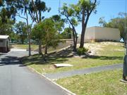
04560 Perth Airport Bushland
Large Conservation Region
| Epoch | General | Specific |
|---|---|---|
| Original Use | PARK\RESERVE | Park\Reserve |
| Present Use | PARK\RESERVE | Park\Reserve |
This information is provided voluntarily as a public service. The information provided is made available in good faith and is derived from sources believed to be reliable and accurate. However, the information is provided solely on the basis that readers will be responsible for making their own assessment of the matters discussed herein and are advised to verify all relevant representations, statements and information.
This information is provided voluntarily as a public service. The information provided is made available in good faith and is derived from sources believed to be reliable and accurate. However, the information is provided solely on the basis that readers will be responsible for making their own assessment of the matters discussed herein and are advised to verify all relevant representations, statements and information.
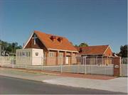
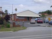
8 Kimberley St Belmont
Belmont
Metropolitan
Constructed from 1961
| Type | Status | Date | Documents |
|---|---|---|---|
| (no listings) |
| Type | Status | Date | Documents |
|---|---|---|---|
| (no listings) |
| Type | Status | Date | Grading/Management | |
|---|---|---|---|---|
| Category | ||||
| Fire & Rescue Service Heritage Inventory | Adopted | 30 Aug 1997 | ||
Individual Building or Group
| Epoch | General | Specific |
|---|---|---|
| Original Use | GOVERNMENTAL | Other |
| Present Use | GOVERNMENTAL | Other |
| Type | General | Specific |
|---|---|---|
| Wall | ASBESTOS | Fibrous Cement, corrugated |
| Wall | BRICK | Common Brick |
| General | Specific |
|---|---|
| SOCIAL & CIVIC ACTIVITIES | Community services & utilities |
This information is provided voluntarily as a public service. The information provided is made available in good faith and is derived from sources believed to be reliable and accurate. However, the information is provided solely on the basis that readers will be responsible for making their own assessment of the matters discussed herein and are advised to verify all relevant representations, statements and information.
Leake St Belmont
Belmont
Metropolitan
| Type | Status | Date | Documents |
|---|---|---|---|
| (no listings) |
| Type | Status | Date | Documents |
|---|---|---|---|
| (no listings) |
| Type | Status | Date | Grading/Management | |
|---|---|---|---|---|
| Category | ||||
| Statewide War Memorial Survey | Completed | 01 May 1996 | ||
19894 Belmont RSL Club
Historic site
| Epoch | General | Specific |
|---|---|---|
| Original Use | MONUMENT\CEMETERY | Monument |
| Present Use | MONUMENT\CEMETERY | Monument |
| Type | General | Specific |
|---|---|---|
| Other | STONE | Granite |
| General | Specific |
|---|---|
| OUTSIDE INFLUENCES | World Wars & other wars |
This information is provided voluntarily as a public service. The information provided is made available in good faith and is derived from sources believed to be reliable and accurate. However, the information is provided solely on the basis that readers will be responsible for making their own assessment of the matters discussed herein and are advised to verify all relevant representations, statements and information.
This information is provided voluntarily as a public service. The information provided is made available in good faith and is derived from sources believed to be reliable and accurate. However, the information is provided solely on the basis that readers will be responsible for making their own assessment of the matters discussed herein and are advised to verify all relevant representations, statements and information.
56 Leake St Belmont
Belmont
Metropolitan
Constructed from 1900
| Type | Status | Date | Documents |
|---|---|---|---|
| Heritage List | Removed | 31 Dec 1996 |
| Type | Status | Date | Documents |
|---|---|---|---|
| (no listings) |
| Type | Status | Date | Grading/Management | |
|---|---|---|---|---|
| Category | ||||
| Local Heritage Survey | Adopted | 27 Jun 2023 | Category 4 | |
| Municipal Inventory | Removed | 22 Nov 2016 | Category 4 | |
| Municipal Inventory | Removed | 31 Dec 1996 | Category 4 | |
Individual Building or Group
| Epoch | General | Specific |
|---|---|---|
| Present Use | RESIDENTIAL | Single storey residence |
| Original Use | RESIDENTIAL | Single storey residence |
| Type | General | Specific |
|---|---|---|
| Roof | METAL | Corrugated Iron |
| Wall | BRICK | Common Brick |
| General | Specific |
|---|---|
| PEOPLE | Early settlers |
This information is provided voluntarily as a public service. The information provided is made available in good faith and is derived from sources believed to be reliable and accurate. However, the information is provided solely on the basis that readers will be responsible for making their own assessment of the matters discussed herein and are advised to verify all relevant representations, statements and information.
Constructed from 1900
Brick and corrugated iron roof single residence set in lush garden surroundings on corner of Leake Street and Wallace Street.
Edward and Susanah Harrison built this house c. 1900. Originally, the dwelling consisted of two rooms and was added to as the size of their family increased. Mr Harrison operated a large plant nursery on the land opposite. The firm of Dawson and Harrison sold their products from a shop in Barrack Street, Perth for many years. However, until the business was established, Mr Dawson took the plants around the district in a horse and cart, selling from door to door.The dwelling was damaged by fire in 2008. A demolition licence was issued on 26 August 2011.
| Reserve | Lot/Location | Plan/Diagram | Vol/Folio |
|---|---|---|---|
| 1 | 51970 | 1469/Folio030 |
This information is provided voluntarily as a public service. The information provided is made available in good faith and is derived from sources believed to be reliable and accurate. However, the information is provided solely on the basis that readers will be responsible for making their own assessment of the matters discussed herein and are advised to verify all relevant representations, statements and information.
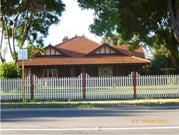
81-91 Leake St Belmont
SES Bunker
Belmont
Metropolitan
Constructed from 1943
| Type | Status | Date | Documents |
|---|---|---|---|
| Heritage List | Adopted | 27 Jun 2023 | |
| Heritage List | Removed | 17 Feb 2003 | |
| State Register | Registered | 28 Feb 2006 | HCWebsite.Listing+ListingDocument, HCWebsite.Listing+ListingDocument |
| Type | Status | Date | Documents |
|---|---|---|---|
| (no listings) |
| Type | Status | Date | Grading/Management | |
|---|---|---|---|---|
| Category | ||||
| Municipal Inventory | Removed | 22 Nov 2016 | Category 1 | |
| Municipal Inventory | Removed | 17 Feb 2003 | Category 1 | |
good
| Name | Type | Year From | Year To |
|---|---|---|---|
| Commonwealth Of Australia - Dept of Interior Perth | Architect | - | - |
| Allied Works Council | Architect | - | - |
| Library Id | Title | Medium | Year Of Publication |
|---|---|---|---|
| 6929 | Standard heritage record for SES bunker, 81-91 Leake Street, Belmont. | Heritage Study {Other} | 2003 |
| 11380 | RAAF Headquaters Bunker (fmr), Belmont | Heritage Study {Cons'n Plan} | 2013 |
Individual Building or Group
| Epoch | General | Specific |
|---|---|---|
| Original Use | MILITARY | Office or Administration Bldg |
| Present Use | COMMERCIAL | Office or Administration Bldg |
| Style |
|---|
| Other Style |
| Type | General | Specific |
|---|---|---|
| Wall | CONCRETE | Other Concrete |
| General | Specific |
|---|---|
| OUTSIDE INFLUENCES | World Wars & other wars |
This information is provided voluntarily as a public service. The information provided is made available in good faith and is derived from sources believed to be reliable and accurate. However, the information is provided solely on the basis that readers will be responsible for making their own assessment of the matters discussed herein and are advised to verify all relevant representations, statements and information.
• The construction and form of the structure is a rare example of a partially subterranean concrete bunker and it is a prominent element in the streetscape. • The place has value as a good example of a building designed by the Allied Works Division and demonstrates an exceptionally high level of technical achievement required to construct a partially subterranean bunker for the purposes of military defence. • The place has historic value for its association with the functions and services established during World War Two by the Commonwealth Government. • The place has social value for the past and present military community and the wider community for its historic and military associations with World War Two. The place has value as a workplace for men and particularly women during World War Two which provided significant opportunities for that workforce.
The Bunker is situated between Epsom Avenue and Leake Street, Belmont and is located within a group of buildings reserved for emergency services purposes. The structure is obscured by mounded earth and has an entrance to the north. A shallow sloping roof over the whole structure is of corrugated zincalume.
The Commonwealth Government constructed an underground communications centre between Epsom Avenue and Leake Street. The radar and signals equipment installed there were operated mainly by members of the Women's Royal Australian Air Force. The place was built in response to the bombing of Broome (3rd March 1942) to provide a better secured facility for the Fighter Sector Headquarters against a possible air raid attacks on Western Australia. The place played an important role as the RAAF Fighter Sector Headquarters, from March 1945 to August 1945, as the centre for the transfer of information from radar station regarding aircraft movements towards the end of World War Two which resulted in the decision to intercept unidentified or suspicious aircraft. The place also played an important role for the Civil Defence and Emergency Department as an available operational headquarters in case of national emergency from 1967 to 2003, and particularly during the Cold War period (1948 to 1989). In 1980 there were upgardes made to the electrical and telecommunications as well as changes to the interior layout of the rooms. The bunker is now part of a complex of buildings that form part of the State Emergency Services headquarters of FESA. It is not known what function the bunker serves in that facility. The three other buildings on the premises were constructed post 1967 by the State Emergency Service (SES) and are considered as having low significance.
Integrity: Moderate Authenticity: Moderate
Good
| Reserve | Lot/Location | Plan/Diagram | Vol/Folio |
|---|---|---|---|
| 18749 | 1 | 3119/Folio56 |
This information is provided voluntarily as a public service. The information provided is made available in good faith and is derived from sources believed to be reliable and accurate. However, the information is provided solely on the basis that readers will be responsible for making their own assessment of the matters discussed herein and are advised to verify all relevant representations, statements and information.
Millar Rd Belmont
Reg Com August 2002: (k) 16634 Perth Airport Hangars It was noted that early airport hangars have been retained at the Maylands airfield site. Allocated to Category Four
Ansett Aircraft Maintenance Complex
Maintenance Sheds
Belmont
Metropolitan
Constructed from 1922 to 1944
| Type | Status | Date | Documents |
|---|---|---|---|
| (no listings) |
| Type | Status | Date | Documents |
|---|---|---|---|
| RHP - Does not warrant assessment | Current | 30 Aug 2002 |
| Type | Status | Date | Grading/Management | |
|---|---|---|---|---|
| Category | ||||
| (no listings) | ||||
| Library Id | Title | Medium | Year Of Publication |
|---|---|---|---|
| 11358 | Cast iron pillar boxes of Western Australia: An early history of the J & E Ledger foundry | Book | 2015 |
Individual Building or Group
| Epoch | General | Specific |
|---|---|---|
| Present Use | Transport\Communications | Air: Hangar |
| Original Use | Transport\Communications | Air: Hangar |
| Type | General | Specific |
|---|---|---|
| Roof | METAL | Corrugated Iron |
| Wall | METAL | Corrugated Iron |
| General | Specific |
|---|---|
| TRANSPORT & COMMUNICATIONS | Air transport |
This information is provided voluntarily as a public service. The information provided is made available in good faith and is derived from sources believed to be reliable and accurate. However, the information is provided solely on the basis that readers will be responsible for making their own assessment of the matters discussed herein and are advised to verify all relevant representations, statements and information.
This information is provided voluntarily as a public service. The information provided is made available in good faith and is derived from sources believed to be reliable and accurate. However, the information is provided solely on the basis that readers will be responsible for making their own assessment of the matters discussed herein and are advised to verify all relevant representations, statements and information.
Perth Airport Belmont
Approx 210ha on the E side of Perth Airport
Belmont
Metropolitan
| Type | Status | Date | Documents |
|---|---|---|---|
| (no listings) |
| Type | Status | Date | Documents |
|---|---|---|---|
| (no listings) |
| Type | Status | Date | Grading/Management | |
|---|---|---|---|---|
| Category | ||||
| Register of the National Estate | Removed from RNE | 23 Dec 1996 | ||
| Classified by the National Trust | Classified | 07 Dec 1994 | ||
| Library Id | Title | Medium | Year Of Publication |
|---|---|---|---|
| 7511 | Master plan 2004 : Perth Airport. | Report | 2004 |
| 7512 | Environment strategy, 2004 : Perth Airport. | Report | 2004 |
Landscape
| Epoch | General | Specific |
|---|---|---|
| Original Use | VACANT\UNUSED | Vacant\Unused |
| Present Use | VACANT\UNUSED | Vacant\Unused |
This information is provided voluntarily as a public service. The information provided is made available in good faith and is derived from sources believed to be reliable and accurate. However, the information is provided solely on the basis that readers will be responsible for making their own assessment of the matters discussed herein and are advised to verify all relevant representations, statements and information.
This information is provided voluntarily as a public service. The information provided is made available in good faith and is derived from sources believed to be reliable and accurate. However, the information is provided solely on the basis that readers will be responsible for making their own assessment of the matters discussed herein and are advised to verify all relevant representations, statements and information.
26 Wallace St Belmont
Belmont
Metropolitan
Constructed from 1940
| Type | Status | Date | Documents |
|---|---|---|---|
| Heritage List | Removed | 17 Feb 2003 |
| Type | Status | Date | Documents |
|---|---|---|---|
| (no listings) |
| Type | Status | Date | Grading/Management | |
|---|---|---|---|---|
| Category | ||||
| Municipal Inventory | Removed | 17 Feb 2003 | Category 3 | |
| Local Heritage Survey | Adopted | 27 Jun 2023 | Category 3 | |
| Municipal Inventory | Removed | 22 Nov 2016 | Category 3 | |
Individual Building or Group
| Epoch | General | Specific |
|---|---|---|
| Present Use | RESIDENTIAL | Single storey residence |
| Original Use | RESIDENTIAL | Single storey residence |
| Type | General | Specific |
|---|---|---|
| Other | TIMBER | Weatherboard |
| Other | METAL | Corrugated Iron |
| General | Specific |
|---|---|
| DEMOGRAPHIC SETTLEMENT & MOBILITY | Land allocation & subdivision |
This information is provided voluntarily as a public service. The information provided is made available in good faith and is derived from sources believed to be reliable and accurate. However, the information is provided solely on the basis that readers will be responsible for making their own assessment of the matters discussed herein and are advised to verify all relevant representations, statements and information.
Constructed from 1940
Weatherboard & iron residence.
Good
| Reserve | Lot/Location | Plan/Diagram | Vol/Folio |
|---|---|---|---|
| 69 |
This information is provided voluntarily as a public service. The information provided is made available in good faith and is derived from sources believed to be reliable and accurate. However, the information is provided solely on the basis that readers will be responsible for making their own assessment of the matters discussed herein and are advised to verify all relevant representations, statements and information.
30 Wallace St Belmont
Belmont
Metropolitan
| Type | Status | Date | Documents |
|---|---|---|---|
| Heritage List | Removed | 17 Feb 2003 |
| Type | Status | Date | Documents |
|---|---|---|---|
| (no listings) |
| Type | Status | Date | Grading/Management | |
|---|---|---|---|---|
| Category | ||||
| Municipal Inventory | Removed | 17 Mar 2003 | Category 4 | |
| Municipal Inventory | Removed | 22 Nov 2016 | Category 4 | |
| Local Heritage Survey | Adopted | 27 Jun 2023 | Category 4 | |
Individual Building or Group
| Epoch | General | Specific |
|---|---|---|
| Original Use | RESIDENTIAL | Single storey residence |
| Present Use | RESIDENTIAL | Single storey residence |
| Type | General | Specific |
|---|---|---|
| Other | TIMBER | Weatherboard |
| Other | TILE | Other Tile |
| General | Specific |
|---|---|
| DEMOGRAPHIC SETTLEMENT & MOBILITY | Land allocation & subdivision |
This information is provided voluntarily as a public service. The information provided is made available in good faith and is derived from sources believed to be reliable and accurate. However, the information is provided solely on the basis that readers will be responsible for making their own assessment of the matters discussed herein and are advised to verify all relevant representations, statements and information.
Weatherboard & Tile Residence.
A demolition licence to remove the original house was issued on 4 August 2005 (Licence No. 103/2005/DEMO). Planning Approval for four grouped dwellings was issued on 11 July 2005 (Application No. 137/2005/DA). The Building Licence for four grouped dwellings (two storey) was issued on 23 August 2005 (Building Licence No. 473/2005/BUILDR). A built strata for the four grouped dwelling was issued 20 June 2007 (Application No. 4/2007/STRATA).
Fair
| Reserve | Lot/Location | Plan/Diagram | Vol/Folio |
|---|---|---|---|
| 11 |
This information is provided voluntarily as a public service. The information provided is made available in good faith and is derived from sources believed to be reliable and accurate. However, the information is provided solely on the basis that readers will be responsible for making their own assessment of the matters discussed herein and are advised to verify all relevant representations, statements and information.
4 Wallace St Belmont
Belmont
Metropolitan
| Type | Status | Date | Documents |
|---|---|---|---|
| Heritage List | Removed | 17 Feb 2003 |
| Type | Status | Date | Documents |
|---|---|---|---|
| (no listings) |
| Type | Status | Date | Grading/Management | |
|---|---|---|---|---|
| Category | ||||
| Municipal Inventory | Removed | 17 Mar 2003 | Category 3 | |
| Municipal Inventory | Removed | 22 Nov 2016 | Category 3 | |
| Local Heritage Survey | Adopted | 27 Jun 2023 | Category 3 | |
Individual Building or Group
| Epoch | General | Specific |
|---|---|---|
| Original Use | RESIDENTIAL | Single storey residence |
| Present Use | RESIDENTIAL | Single storey residence |
| Type | General | Specific |
|---|---|---|
| Other | METAL | Corrugated Iron |
| Other | TIMBER | Weatherboard |
| General | Specific |
|---|---|
| DEMOGRAPHIC SETTLEMENT & MOBILITY | Land allocation & subdivision |
This information is provided voluntarily as a public service. The information provided is made available in good faith and is derived from sources believed to be reliable and accurate. However, the information is provided solely on the basis that readers will be responsible for making their own assessment of the matters discussed herein and are advised to verify all relevant representations, statements and information.
• The house has aesthetic value as a representative example of the application of the form and detail of the Federation Bungalow style applied to simple homes. • The place has historic value for its association with the early settlement of this area of Belmont in the first half of the 20th century. • The place has historic value as a demonstration of the size and scale of homes for working families.
A simple symetrical plan form timber framed residence with a zincalume hipped roof with a brick chinney with chimney pots. Verandahs are located on three sides and these are covered with separate bull nose roofs supported on decorative turned timber posts. The main façade features a centrally placed door with a fanlight and sidelights, all of which are painted over. Aluminium sliding windows located either side of the front door are later insertions.
This portion of Belmont was subdivided for residential occupancy some time after areas further south and east. Aerial photographs show that signifcant portions of land were withheld from development to enable drainage through to the river. This house on the south side of Wallace Street was one of the few built in the area by the mid 1960s. No detail of the original owner or occupant has been found in this research. Although Post Office Directory information suggests it was occupied by Robert Sharp in the 1940s. Physical evidence suggests it was built in the 1910s to 1920s. Since then the house has undergone addtions to the rear and in 2012 the lot was subdivided enabling the construction of a new residence in the rear half of the lot. The form and extent of the original house is still evident.
Integrity: High Authenticity: Moderate
Good
| Reserve | Lot/Location | Plan/Diagram | Vol/Folio |
|---|---|---|---|
| 851 |
This information is provided voluntarily as a public service. The information provided is made available in good faith and is derived from sources believed to be reliable and accurate. However, the information is provided solely on the basis that readers will be responsible for making their own assessment of the matters discussed herein and are advised to verify all relevant representations, statements and information.
201 Great Easterm Highway Burswood
Burswood Island Golf Course
Rivervale Tip
Belmont
Metropolitan
Constructed from 1909
| Type | Status | Date | Documents |
|---|---|---|---|
| (no listings) |
| Type | Status | Date | Documents |
|---|---|---|---|
| RHP - Does not warrant assessment | Current | 22 Feb 2019 |
| Type | Status | Date | Grading/Management | |
|---|---|---|---|---|
| Category | ||||
| (no listings) | ||||
• The place is associated with the development of Perth’s waste management, including the development of sewerage treatment and prior use as a rubbish dump.
• The place demonstrates the post-war redevelopment of the Swan River into recreation areas, including rehabilitation areas of previous industrial or waste management use.
The place is associated with the development of Perth’s waste management, including the development of sewerage treatment and prior use as a rubbish dump. The place demonstrates the post-war redevelopment of the Swan River into recreation areas, including rehabilitation areas of previous industrial or waste management use
Burswood Tip (fmr) is located on the Burswood Peninsula in the Town of Victoria Park within the metropolitan region, the area lying on the southwest portion of the peninsula south of the recently-developed stadium. The current use and layout of the place is a recreational park. Recent landscaping associated with the development of Optus Stadium includes the planting of new trees and lawns, the establishment of roads and pathways, as well as the addition of nearby parking areas. The area’s history as a former rubbish tip and sewerage treatment area is not visible in the current landscape.
The Burswood peninsula took its name from the family estate of English settler Henry Camfield, who arrived in Western Australia on 12 October 1829. Camfield was disappointed with his original land grants in the colony but succeeded in getting Surveyor General J. S. Roe to grant him 1,000 acres which included the peninsula, previously reserved for Crown purposes. The area was eventually taken up with large land grants, and the addition of transported convict labour after 1850 provided for the development of roads and bridges in the area. By the 1880s, there approximately 100 houses in the area. A slowly developing economy saw the subdivision and sale of the larger land grants for residential purposes, one of the earliest being the “Victoria Park Estate” in 1887. The discovery of gold in the 1890s saw a flood of new settlers and by the turn of the century more of the original farms were being converted into residential and commercial areas. This process of urbanisation accelerated in the inter-war period, as well as seeing industrial enterprises such as the Portland Cement Works take up position on the previously unutilised riverside areas. While sewerage treatment plants had been located at Burswood island c.1909, the swampy area was considered a health hazard due to the mosquitos that bred there. The noxious smells and river pollution from the sewerage filtration beds remained a bone of public contention throughout this period. Part of the process of the sewerage treatment during this time was the removal of rubbish from the filtration beds, which was buried in the foreshore of the river. The situation was finally resolved by 1936 when the Metropolitan Sewerage Service was established to replace the aging Burswood plant. The area appears to have still been used as an illegal rubbish dump at this point. Burswood Tip (also known as the Rivervale Tip for a time) operated from 1946 until 1985. It initially recieved fly ash from the East Perth Power Station on the other side of the river, but after 1954 also recieved local rubbish from the surrounding area. It closed for several years in 1972 but was reopened briefly for general waste in 1978. From 1979 it was only used for the recieving, chipping and storing garden waste and tree prunings before they were taken elsewhere. It was close din 1985 and the land was developed for the Burswood Island Gold Course.
Urban Open Space
| General | Specific |
|---|---|
| DEMOGRAPHIC SETTLEMENT & MOBILITY | Environmental change |
| DEMOGRAPHIC SETTLEMENT & MOBILITY | Technology & technological change |
| SOCIAL & CIVIC ACTIVITIES | Environmental awareness |
| SOCIAL & CIVIC ACTIVITIES | Sport, recreation & entertainment |
| SOCIAL & CIVIC ACTIVITIES | Community services & utilities |
This information is provided voluntarily as a public service. The information provided is made available in good faith and is derived from sources believed to be reliable and accurate. However, the information is provided solely on the basis that readers will be responsible for making their own assessment of the matters discussed herein and are advised to verify all relevant representations, statements and information.
121 Arlunya Av Cloverdale
Lot 62 on Diagram 42492
Belmont
Metropolitan
Constructed from 1973
| Type | Status | Date | Documents |
|---|---|---|---|
| (no listings) |
| Type | Status | Date | Documents |
|---|---|---|---|
| (no listings) |
| Type | Status | Date | Grading/Management | |
|---|---|---|---|---|
| Category | ||||
| Anglican Church Inventory | YES | 31 Jul 1996 | ||
Individual Building or Group
| Epoch | General | Specific |
|---|---|---|
| Original Use | RELIGIOUS | Church, Cathedral or Chapel |
| Present Use | RELIGIOUS | Church, Cathedral or Chapel |
| Type | General | Specific |
|---|---|---|
| Roof | TILE | Cement Tile |
| Wall | BRICK | Common Brick |
| General | Specific |
|---|---|
| SOCIAL & CIVIC ACTIVITIES | Religion |
This information is provided voluntarily as a public service. The information provided is made available in good faith and is derived from sources believed to be reliable and accurate. However, the information is provided solely on the basis that readers will be responsible for making their own assessment of the matters discussed herein and are advised to verify all relevant representations, statements and information.
324 Belmont Av Cloverdale
Lot 1
Belmont Christian Fellowship Church
Belmont
Metropolitan
Constructed from 1950
| Type | Status | Date | Documents |
|---|---|---|---|
| Heritage List | Adopted | 27 Jun 2023 |
| Type | Status | Date | Documents |
|---|---|---|---|
| (no listings) |
| Type | Status | Date | Grading/Management | |
|---|---|---|---|---|
| Category | ||||
| (no listings) | ||||
Largely intact with the exception of the hall addition. Good
Individual Building or Group
| Epoch | General | Specific |
|---|---|---|
| Original Use | RELIGIOUS | Church, Cathedral or Chapel |
| Present Use | RELIGIOUS | Church, Cathedral or Chapel |
| Type | General | Specific |
|---|---|---|
| Roof | TILE | Other Tile |
| Wall | BRICK | Common Brick |
| General | Specific |
|---|---|
| SOCIAL & CIVIC ACTIVITIES | Religion |
This information is provided voluntarily as a public service. The information provided is made available in good faith and is derived from sources believed to be reliable and accurate. However, the information is provided solely on the basis that readers will be responsible for making their own assessment of the matters discussed herein and are advised to verify all relevant representations, statements and information.
Constructed from 1950
• The church has value for its association with the development of the Belmont community in the period following World War Two. • The church has social value for its association with many members of the community who fundraised and built this church for their congregation. • The place has social and spiritual value for the many members of the community who have visited this place ince 1950. • This church is a simple demonstration of the Post War International style executed in brick and tile. • The church and associated buildings are a landmark in the streetscape.
A simple rectangular brick building of a symmetrical plan with a pitched tile roof. Regularly spaced buttresses are located on the long elevation and windows are located within the spaces created. Entrance to the church nave is through a small brick vestibule which is rendered and painted with a flat roof. Entrance to the vestibule is via double timber doors which are located on a concrete porch covered by a timber pergola which gives weather protection. Adjoining the church is a hall of similar design, materials and scale which differs from the church through the shallower pitched roof. Asphalt paving surrounds the two buildings which provides generous parking. Some planter boxes are located close to the two buildings. The buildings are well maintained and appear to be in good condition.
In c1927, when the area now known as Cloverdale was part of South Belmont, interested Christians of the then very scattered population decided to form a nondenominational Church group and Sunday School. Some of the pioneers of this work were Mr and Mrs Vose, Mr and Mrs Butler, Mr and Mrs Duncan, Mr N. Bell, Mr J. Howard, Mrs I. Blomfield, Mr A. Blomfield, Mrs Greenway and Mrs Dixon. Worship commenced with once a month evening meetings and visiting lay preachers from various denominations conducted the services. Buses and cars being scarce, most people attended by walking or bicycling the distance which was often up to two or three miles. In the early years of the Church’s history, the main meetings, including one Sunday School, were held in the old wooden South Belmont Soldiers’ Memorial Hall, on the corner of Wright Street and Belmont Avenue. The work grew to weekly meetings plus Sunday School classes being held at two venues and a midweek youth meeting called ‘Band of Hope’. The second Sunday School classes were held in the then South Belmont Primary School. The entire congregation united for anniversaries, Sunday School picnics at the Zoo and fireworks displays which were held where the present Belmont Shopping Centre is now located. Every month at general meetings, when the accounts were paid, the congregation decided to which Missions the remaining moneys would be allocated. Eventually the Church became quite involved in Missions and assisted both overseas and Australian missionaries. A very close attachment was made to Mt. Margaret Mission near Leonora. The group was known as the South Belmont Mission Church. The present building on the corner of Belmont Avenue and Keane Street was erected entirely by the congregation in 1950 and the hall at the rear was added in 1972. In the early 1960’s the conregation was incorporated in the People’s Church of Perth under the direction of Pastor Phil Peterson. He oversaw the incorporation of the group as an self-supporting Independent Christian Group under the name ‘Belmont Christian Fellowship’. Since that time the church has continued to serve as a church for the local community and is currently using the name 'Perth Christian Alliance'. The form and extent of the original church can still be determined despite some minor modifications in the detail on the main elevation.
Integrity: High Authenticity: High
Good
| Reserve | Lot/Location | Plan/Diagram | Vol/Folio |
|---|---|---|---|
| 1 | 13897 |
This information is provided voluntarily as a public service. The information provided is made available in good faith and is derived from sources believed to be reliable and accurate. However, the information is provided solely on the basis that readers will be responsible for making their own assessment of the matters discussed herein and are advised to verify all relevant representations, statements and information.
39 Elizabeth Street Cloverdale
Lot 100, D89245
Belmont
Metropolitan
| Type | Status | Date | Documents |
|---|---|---|---|
| (no listings) |
| Type | Status | Date | Documents |
|---|---|---|---|
| (no listings) |
| Type | Status | Date | Grading/Management | |
|---|---|---|---|---|
| Category | ||||
| Local Heritage Survey | Adopted | 27 Jun 2023 | Category 4 | |
Individual Building or Group
| Epoch | General | Specific |
|---|---|---|
| Original Use | EDUCATIONAL | Museum |
| Style |
|---|
| Late 20th-Century Aust'n Nostalgic |
| Type | General | Specific |
|---|---|---|
| Wall | BRICK | Common Brick |
| Roof | OTHER | Other Material |
| General | Specific |
|---|---|
| SOCIAL & CIVIC ACTIVITIES | Cultural activities |
This information is provided voluntarily as a public service. The information provided is made available in good faith and is derived from sources believed to be reliable and accurate. However, the information is provided solely on the basis that readers will be responsible for making their own assessment of the matters discussed herein and are advised to verify all relevant representations, statements and information.
Constructed from 1988
• The place is associated with the period in which the Belmont community began to celebrate and acknowledge its past through the collection and display of items relevant to the history of Belmont. • The place has value for its association with the former Belmont Historical Society founded in 1981 who were instrumental in the collection of items and documentation of the City of Belmont's history. • Since 1989, the place was regularly opened to the public and was visited by many school groups from the City of Belmont and the greater metropolitan area.
1980s red brick building with colorbond roof and a verandah to all sides of the building and shallow pitched gables with timber lattice to the roof. Windows are aluminium framed with security bars. A rock near the main entrance has plaques acknowledging the contributions to the establishment of the museum.
This building was constructed in 1987/88 by the City of Belmont as a Bicenntennial Project and followed the formation of the Belmont Historical Society in 1981. There were close links between the City and the Historical Society with several individuals holding key roles in both organisations. The museum provided display and research space for a significant collection and was entirely managed by volunteers. The volunteers provided group tours and organised activities for school groups. In 2012 there was Memorandum of Understanding put in place with the City to start taking over the management and running of the Museum. The collection and the museum display was relocated to the Belmont Hub in late 2020. Since that time the former museum has been used for a range of community functions.
Integrity: Low Authenticity: High
Good
| Ref ID No | Ref Name | Ref Source | Ref Date |
|---|---|---|---|
| Maxine Laurie, 'Ever Flowing Forward The Story of Belmont' | City of Belmont | 1999 | |
| Aerial Photographs | Landgate | 1953-2016 |
| Owner | Category |
|---|---|
| Local Government | Local Gov't |
This information is provided voluntarily as a public service. The information provided is made available in good faith and is derived from sources believed to be reliable and accurate. However, the information is provided solely on the basis that readers will be responsible for making their own assessment of the matters discussed herein and are advised to verify all relevant representations, statements and information.
254 Fulham St Cloverdale
Bell Residence (fmr)
Belmont
Metropolitan
Constructed from 1915
| Type | Status | Date | Documents |
|---|---|---|---|
| Heritage List | Adopted | 27 Jun 2023 |
| Type | Status | Date | Documents |
|---|---|---|---|
| (no listings) |
| Type | Status | Date | Grading/Management | |
|---|---|---|---|---|
| Category | ||||
| (no listings) | ||||
Appears largely intact Good
Bell
Individual Building or Group
| Epoch | General | Specific |
|---|---|---|
| Original Use | FARMING\PASTORAL | Homestead |
| Present Use | RESIDENTIAL | Single storey residence |
| Type | General | Specific |
|---|---|---|
| Roof | TILE | Other Tile |
| Wall | BRICK | Common Brick |
| General | Specific |
|---|---|
| OCCUPATIONS | Rural industry & market gardening |
| PEOPLE | Local heroes & battlers |
This information is provided voluntarily as a public service. The information provided is made available in good faith and is derived from sources believed to be reliable and accurate. However, the information is provided solely on the basis that readers will be responsible for making their own assessment of the matters discussed herein and are advised to verify all relevant representations, statements and information.
Constructed from 1915
• The place has aesthetic value as a large and rare example of the Californian Bungalow style executed in concrete block construction. • The place has historic value for its association with the establishment and development of the poultry industry in the Belmont district in the Inter War years. • The Oakland Poultry Farm on this site was a leader in the industry and the name has been used in an adjacent subdivision. • The place has historic value for its association with the Bell family who lived and worked at this place from the 1920s to the 1980s. • The place has social value for its demonstration of the size and scale of a family home which was originally more typically a farming homestead.
Brick and tile residence.
This substantial residence was built by Frederick William Bell (c1892-1948) and his wife Edna Hilda Bell (c1893-1936) c1935. The couple had established a poultry farm on a large parcel of land bound by Fulham, Fisher and Gabriel Streets and Abernethy Road. From the available information, Frederick and Edna Bell had been living and working in Kellerberrin before relocating to Belmont c1920 with their two children. Electoral Rolls record Frederick and Edna living in Belmont from at least 1921 and in the same year, George Bell was living in Fulham Street Belmont which suggests the property was a family investment at that time. In subsequent years it seems only Frederick and Edna were living on the property. By 1924, Frederick Bell had established his business as the 'Oakland Poultry Farm' and was advertising widely in local papers, particularly the 'Eastern Recorder' which was distributed in Kellerberrin. Information from a member of the Bell family cited in Maxine Laurie's book, states that the Bell family worked hard and were successful in establishing their business. In 1935, the introduction of the electric incubator had a significant effect on the poultry industry and the farm was able to increase stock numbers and increase profits. It is understood that it was at this time that the family home was built. Its scale and original outbuildings evident in aerial photographs from the mid 20th century demonstrate its function as a farm homestead. The use of concrete blocks in the construction of the house is interesting and perhaps reflects the sluggish economy of the early 1930s recovering from the Depression. Brick manufacturing was slow at this time and it was difficult to source bricks for private homes. In 1936, a tragic accident lead to the death of Edna Bell from a gun shot wound. Frederick and his son Norman continued to operate the farm although Norman did leave to serve with the AIF during World War Two. Norman Bell had a successful career in poultry farming particularly as he was a skilled chicken sexer. A technique that was introduced to Western Australia in c1936. Following Frederick's death in 1948, Norman and his wife Patricia continued the family farm together with his sister Elsie and her husband Alfred Yates. In the 1950s it seems Elsie and Alfred took over the property on their own and continue to live there until the 1980s. A subdivision plan for the land was approved in 1970 and from that time the lots have been slowly developed. The Bell family home remains on a lot larger than those adjacent but smaller than its original setting.
Integrity: High Authenticity: High
Good
| Reserve | Lot/Location | Plan/Diagram | Vol/Folio |
|---|---|---|---|
| 95 | 39865 | 1385/Folio 75 |
This information is provided voluntarily as a public service. The information provided is made available in good faith and is derived from sources believed to be reliable and accurate. However, the information is provided solely on the basis that readers will be responsible for making their own assessment of the matters discussed herein and are advised to verify all relevant representations, statements and information.
18 Kelly St Cloverdale
Belmont
Metropolitan
Constructed from 1963
| Type | Status | Date | Documents |
|---|---|---|---|
| (no listings) |
| Type | Status | Date | Documents |
|---|---|---|---|
| (no listings) |
| Type | Status | Date | Grading/Management | |
|---|---|---|---|---|
| Category | ||||
| Catholic Church Inventory | Adopted | 01 Jul 1998 | ||
sound
Individual Building or Group
| Epoch | General | Specific |
|---|---|---|
| Original Use | RESIDENTIAL | Single storey residence |
| Present Use | RELIGIOUS | Housing or Quarters |
| Type | General | Specific |
|---|---|---|
| Roof | TILE | Ceramic Tile |
| Wall | BRICK | Common Brick |
| General | Specific |
|---|---|
| SOCIAL & CIVIC ACTIVITIES | Religion |
This information is provided voluntarily as a public service. The information provided is made available in good faith and is derived from sources believed to be reliable and accurate. However, the information is provided solely on the basis that readers will be responsible for making their own assessment of the matters discussed herein and are advised to verify all relevant representations, statements and information.
314 Kew St Cloverdale
Belmont
Metropolitan
Constructed from 1951 to 1956
| Type | Status | Date | Documents |
|---|---|---|---|
| Heritage List | Removed | 31 Dec 1996 | |
| Heritage List | Adopted | 27 Jun 2023 |
| Type | Status | Date | Documents |
|---|---|---|---|
| (no listings) |
| Type | Status | Date | Grading/Management | |
|---|---|---|---|---|
| Category | ||||
| Municipal Inventory | Removed | 31 Dec 1996 | Category 2 | |
| Municipal Inventory | Removed | 22 Nov 2016 | Category 2 | |
Individual Building or Group
| Epoch | General | Specific |
|---|---|---|
| Present Use | RESIDENTIAL | Two storey residence |
| Original Use | RESIDENTIAL | Two storey residence |
| Type | General | Specific |
|---|---|---|
| Roof | TILE | Other Tile |
| Wall | BRICK | Rendered Brick |
| General | Specific |
|---|---|
| PEOPLE | Local heroes & battlers |
This information is provided voluntarily as a public service. The information provided is made available in good faith and is derived from sources believed to be reliable and accurate. However, the information is provided solely on the basis that readers will be responsible for making their own assessment of the matters discussed herein and are advised to verify all relevant representations, statements and information.
Constructed from 1951, Constructed from 1956
• The place has aesthetic value as a modest demonstration of the Inter War Spanish Mission style. • The place is prominent in the streetscape because of its location on a high traffic road and its unusual design in the region. • The place has historic value for its association with the period following World War Two when building materials were scarce and many homes where built by their occupants. • The place has historic value for its assocation with the period following World War Two when the population of metropolitan Perth grew and the outer suburbs became more densely settled. • The place is a good demonstration of the style and scale of housing in the post war period and the resourcefulness of the owner builders. • The construction of the cement bricks used in this property may provide information about the techniques and materials used during the post war period.
The two storey residence is set in picturesque garden surroundings. It displays elements of the Inter war Spanish Mission style with a high pitched roof and curved doorway. The building is of homemade cement bricks, which have been rendered over and painted, a terracotta tile roof and zinc light windows. The house is situated on a main road and abuts a recreation reserve. It is clearly visible to all passers by and is one of the landmark houses in the district.
Clement William Hay (c1927-1975) and his wife Stella Beryl Hay commenced building their home in 1951 and the building was completed in 1956. During the period of construction,the family lived in a shed on the land, which comprised of 3 acres. The landholding has now been reduced to between 2.5 and 2.75 acres. Clem Hay was a carpenter and he undertook the majority of the construction of the house whilst living on the property. After Clem's death in 1975, Stella lived on in the house with her two children into the 1980s. The property subsequently transferred to the State government.
Integrity: High Authenticity: High
Good
| Reserve | Lot/Location | Plan/Diagram | Vol/Folio |
|---|---|---|---|
| 1 | 16015 | 1678/Folio955 |
This information is provided voluntarily as a public service. The information provided is made available in good faith and is derived from sources believed to be reliable and accurate. However, the information is provided solely on the basis that readers will be responsible for making their own assessment of the matters discussed herein and are advised to verify all relevant representations, statements and information.
Located within Faulkner Park Cloverdale
Located within Faulkner Civic Precinct - Bound by Wright Street, Abernethy Road & Robinson Avenue & Alexander Road
Belmont
Metropolitan
| Type | Status | Date | Documents |
|---|---|---|---|
| (no listings) |
| Type | Status | Date | Documents |
|---|---|---|---|
| (no listings) |
| Type | Status | Date | Grading/Management | |
|---|---|---|---|---|
| Category | ||||
| Local Heritage Survey | Adopted | 27 Jun 2023 | Category 3 | |
Historic site
| Epoch | General | Specific |
|---|---|---|
| Original Use | MONUMENT\CEMETERY | Monument |
| Type | General | Specific |
|---|---|---|
| Other | STONE | Granite |
| General | Specific |
|---|---|
| SOCIAL & CIVIC ACTIVITIES | Community services & utilities |
This information is provided voluntarily as a public service. The information provided is made available in good faith and is derived from sources believed to be reliable and accurate. However, the information is provided solely on the basis that readers will be responsible for making their own assessment of the matters discussed herein and are advised to verify all relevant representations, statements and information.
Constructed from 1979
• The memorial has historic value for its recognition of the contribution of the Country Women’s Association to the establishment and development of the Belmont region in the mid-20th century. • The memorial has social value for its association with the Country Women’s Association which provided a means of connection for many women in Belmont when it was a relatively remote settlement in the early and mid 20th century. • The memorial has aesthetic value for its expression of a style from the 1970s and its contribution to the overall aesthetic of the park which demonstrates a range of styles unified by mature gardens and waterways.
The memorial fountain is located on the edge of the eastern side of the smaller lake within Faulkner Park and visible from Progress Way. The fountain is formed of random rocks surmounted by one large boulder. The rocks are laid down to the edge of the lake to enable water to flow into the lake. Curved concrete kerbing surrounds the fountain and incorporates it into the kerbing of the lake. A small plaque is located on the curb near Progress Way denoting the date and purpose of the structure. It appears that the fountain has not operated for many years and it is not apparent where the source of water originates.
The park was developed by the City of Belmont beginning in the late 1960s, when the site was roughly divided in two with the southern portion featuring a simple grassed sports ground and change rooms. The northern half was cleared but undeveloped. During the 1970s the gardens across the site were established and developed with lakes a key feature of the landscape. As part of the garden redevelopment the Belmont War Memorial was relocated from Great Eastern Highway in 1972 to its current location in the precinct. On 17 February 1979, the Belmont Administration Centre was opened by the Governor of Western Australia, Sir Wallace Kyle. As part of the ceremony, Belmont was declared a City. As part of the works in 1979, a fountain was constructed alongside one of the lakes. The project was part of the State’s 150th anniversary, as a joint project between the Belmont City Council and the Belmont-Rivervale and Cloverdale branches of the Country Women’s Association (CWA). Both these branches are no longer functioning and the water feature remains as a reminder of the role of the CWA in Belmont. The Country Women’s Association was a valuable support network for the settlers of the region in the mid 20th century as they provided an opportunity for women and the wider community to come together and share their experiences and knowledge.
Integrity: High Authenticity: High
| Ref ID No | Ref Name | Ref Source | Ref Date |
|---|---|---|---|
| City of Belmont (Heritage) Inventory 2016 | |||
| Aerial photographs, 1953-2016, Landgate. |
| Reserve | Lot/Location | Plan/Diagram | Vol/Folio |
|---|---|---|---|
| Lot 52 | DP31398 | 107/21 |
This information is provided voluntarily as a public service. The information provided is made available in good faith and is derived from sources believed to be reliable and accurate. However, the information is provided solely on the basis that readers will be responsible for making their own assessment of the matters discussed herein and are advised to verify all relevant representations, statements and information.
347 Wright St Cloverdale
Belmont
Metropolitan
Constructed from 1971
| Type | Status | Date | Documents |
|---|---|---|---|
| (no listings) |
| Type | Status | Date | Documents |
|---|---|---|---|
| (no listings) |
| Type | Status | Date | Grading/Management | |
|---|---|---|---|---|
| Category | ||||
| Catholic Church Inventory | Adopted | 01 Jul 1998 | ||
good
Individual Building or Group
| Epoch | General | Specific |
|---|---|---|
| Original Use | RELIGIOUS | Housing or Quarters |
| Present Use | RELIGIOUS | Church, Cathedral or Chapel |
| Original Use | RELIGIOUS | Church, Cathedral or Chapel |
| Style |
|---|
| Late 20th-Century Ecclesiastical |
| Type | General | Specific |
|---|---|---|
| Wall | ASBESTOS | Asbestos Tile |
| Roof | TILE | Ceramic Tile |
| General | Specific |
|---|---|
| SOCIAL & CIVIC ACTIVITIES | Religion |
This information is provided voluntarily as a public service. The information provided is made available in good faith and is derived from sources believed to be reliable and accurate. However, the information is provided solely on the basis that readers will be responsible for making their own assessment of the matters discussed herein and are advised to verify all relevant representations, statements and information.
| Reserve | Lot/Location | Plan/Diagram | Vol/Folio |
|---|---|---|---|
| 100 | 67549 | 2826/630 |
This information is provided voluntarily as a public service. The information provided is made available in good faith and is derived from sources believed to be reliable and accurate. However, the information is provided solely on the basis that readers will be responsible for making their own assessment of the matters discussed herein and are advised to verify all relevant representations, statements and information.
392 Acton Av Kewdale
Hampton's Stud Farm
The Hatchery
Belmont
Metropolitan
| Type | Status | Date | Documents |
|---|---|---|---|
| Heritage List | Removed | 28 Feb 2012 |
| Type | Status | Date | Documents |
|---|---|---|---|
| (no listings) |
| Type | Status | Date | Grading/Management | |
|---|---|---|---|---|
| Category | ||||
| Municipal Inventory | Removed | 28 Feb 2012 | Category 3 | |
| Local Heritage Survey | Adopted | 27 Jun 2023 | Category 3 | |
Individual Building or Group
| Epoch | General | Specific |
|---|---|---|
| Original Use | FARMING\PASTORAL | Other |
| Present Use | FARMING\PASTORAL | Other |
| Type | General | Specific |
|---|---|---|
| Roof | METAL | Corrugated Iron |
| Wall | BRICK | Common Brick |
| General | Specific |
|---|---|
| OCCUPATIONS | Rural industry & market gardening |
This information is provided voluntarily as a public service. The information provided is made available in good faith and is derived from sources believed to be reliable and accurate. However, the information is provided solely on the basis that readers will be responsible for making their own assessment of the matters discussed herein and are advised to verify all relevant representations, statements and information.
Constructed from 1930
• The place has aesthetic value as a demonstration of a simple Inter War Californian bungalow style residence with a complex of industrial buildings that have evolved over several decades. • The place has historic value for its ongoing association with the poultry industry which was significant to the development of the district. • The place has social value for its association with early poultry farmers, the Hamptons and Machlin who were leaders in the establishment of the poultry industry in Belmont. • This place has been an employer of many members of the Belmont community since the 1930s.
Machlin’s Poultry Farm is a group of modern functional brick and iron factory buildings, with an associated c.1940s brick and title residence.
A poultry farm was established c1934 by Abraham and Esther Machlin, originally from Palestine. The earliest reference found to a poultry farm near the location was a 1935 advertisement for ‘Machlin’s Poultry Farm’, Acton Avenue, near South Belmont School (now called Kewdale Primary School) (West Australian, 22 October 1935). The Machlin property was originally 10 acres and had basic accommodation for the family of four children. Sons Amos and Max Machlin recall the building of the family home in the late 1930s. The family owned the property until 1947 and sought to sell it prior to that date. In 1945, Machlin’s Poultry Farm was described as follows: Total area 33 acres 10 roods, 26 perches…, with attractive modern brick residence, with 5 large rooms and sleepout, men’s quarters, garages, workshop, plucking room, incubator rooms, feed house, storeroom, brooder houses and numerous fowl houses and runs, pump house, reticulation system, tanks, all necessary plant and machinery (including electric 15,000 egg incubator), approximately 2,300 laying fowls, 3,000 growers and 700 chicks, 1 mare and 1 cow in milk. The property includes swamp land with good dark soil and a plentiful permanent water supply and enabling the growing of ample green feed. This is a very well equipped poultry farm, supplying large quantities of eggs, day-old chicks and dressed poultry to customers of long standing. Sunday Times, 28 October 1945 It seems likely that Alf Hampton was operating the business prior to the transfer of purchased Machlin’s Poultry Farm in 1945, as in 1946 he was advertising himself both as the owner of Machlin Poultry Farm and of Hampton’s Stud Farm at the same address (Scott Street). Hampton became more interested in racing, together with his son Ken, winning the Ascot Handicap with Alabama in 1954 (West Australian, 27 January 1954). Eventually he required more space for this side of his business and he relocated to Byford. The poultry farm was then acquired by Max Machlin, son of Abraham Machlin, the original owner. The place continues to operate as a chicken hatchery with additions and alterations to the sheds on the major portion of the lot to accommodate new methods and standards. The residence appears to be used for that purpose although the commercial functions have encroached onto the former garden.
Integrity: Residence - High Authenticity: Residence - High
Good
| Ref ID No | Ref Name | Ref Source | Ref Date |
|---|---|---|---|
| Laurie, Maxine, Ever Flowing Forward: The Story of Belmont (1999) | Eddie Marcus, History Now | 10/2011 |
| Reserve | Lot/Location | Plan/Diagram | Vol/Folio |
|---|---|---|---|
| 5 | 11022 |
This information is provided voluntarily as a public service. The information provided is made available in good faith and is derived from sources believed to be reliable and accurate. However, the information is provided solely on the basis that readers will be responsible for making their own assessment of the matters discussed herein and are advised to verify all relevant representations, statements and information.