Local Government
Belmont
Region
Metropolitan
190 Belmont Av Kewdale
Belmont
Metropolitan
| Type | Status | Date | Documents |
|---|---|---|---|
| Heritage List | Removed | 28 Feb 2012 |
| Type | Status | Date | Documents |
|---|---|---|---|
| (no listings) |
| Type | Status | Date | Grading/Management | |
|---|---|---|---|---|
| Category | ||||
| Municipal Inventory | Removed | 22 Nov 2016 | Category 3 | |
| Local Heritage Survey | Adopted | 27 Jun 2023 | Category 3 | |
| Municipal Inventory | Removed | 28 Feb 2012 | Category 3 | |
Individual Building or Group
| Epoch | General | Specific |
|---|---|---|
| Present Use | RESIDENTIAL | Single storey residence |
| Original Use | RESIDENTIAL | Single storey residence |
| Type | General | Specific |
|---|---|---|
| Wall | TIMBER | Other Timber |
| Roof | METAL | Corrugated Iron |
| General | Specific |
|---|---|
| DEMOGRAPHIC SETTLEMENT & MOBILITY | Land allocation & subdivision |
This information is provided voluntarily as a public service. The information provided is made available in good faith and is derived from sources believed to be reliable and accurate. However, the information is provided solely on the basis that readers will be responsible for making their own assessment of the matters discussed herein and are advised to verify all relevant representations, statements and information.

Constructed from 1920
• The place has aesthetic value as a representative example of a modest timber residence built for tradesmen and small business holders during the Inter War years. • The place has historic value as its associated with the development of the region for farming in the Inter War years. • The place has social value for its association with Herbert Roberts who established one of the first dairys in the district.
This single storey timber framed residence with a colored zincalume roof has a simple symmetrical presentation. The central entrance is a single door without fanlight or side panels. The flanking windows are three-sectioned casement windows. The verandah is an extension of the roof form supported on simple timber posts. The original timber weatherboard cladding of the house has been replaced with a later product of a similar profile. The residence is enclosed within ametal fence of approximately 1800mm high, clad to half its height with corrugated sheeting which limits the view of the place from the street. The garden features some mature trees which may date from its original construction.
Herbert Henry Roberts (c.1880-1938) had worked in the Western Australia Goldfields in the 1890s, and arrived in Perth in 1912. He settled in South Belmont in the early 1920s, purchasing a block on the corner of Uranium Street and Belmont Avenue in 1922 to establish a dairy. This house was built c1923 but no detail of the builder has been found. Roberts was one of the first farmers to install a milking machine after the installation of electricity in the late 1920s. Roberts resided in Belmont Avenue until his death in 1938. Aerial photographs indicate the house was extended to the rear in the 1980s, which was subsequently modified in 2015 to enable the construction of a new building in the rear of the lot. The original form and extent of the residence can still be readily determined.
Integrity: High Authenticity: High
Good
| Ref ID No | Ref Name | Ref Source | Ref Date |
|---|---|---|---|
| Eddie Marcus | History Now | 10/2011 |
| Reserve | Lot/Location | Plan/Diagram | Vol/Folio |
|---|---|---|---|
| 34 | 1719 |
This information is provided voluntarily as a public service. The information provided is made available in good faith and is derived from sources believed to be reliable and accurate. However, the information is provided solely on the basis that readers will be responsible for making their own assessment of the matters discussed herein and are advised to verify all relevant representations, statements and information.
193 Belmont Av Kewdale
Belmont
Metropolitan
| Type | Status | Date | Documents |
|---|---|---|---|
| Heritage List | Removed | 28 Feb 2012 |
| Type | Status | Date | Documents |
|---|---|---|---|
| (no listings) |
| Type | Status | Date | Grading/Management | |
|---|---|---|---|---|
| Category | ||||
| Municipal Inventory | Removed | 22 Nov 2016 | Category 3 | |
| Municipal Inventory | Removed | 28 Feb 2012 | Category 3 | |
| Local Heritage Survey | Adopted | 27 Jun 2023 | Category 4 | |
Individual Building or Group
| Epoch | General | Specific |
|---|---|---|
| Present Use | RESIDENTIAL | Single storey residence |
| Original Use | RESIDENTIAL | Single storey residence |
| Type | General | Specific |
|---|---|---|
| Wall | BRICK | Common Brick |
| Roof | TILE | Other Tile |
| General | Specific |
|---|---|
| DEMOGRAPHIC SETTLEMENT & MOBILITY | Land allocation & subdivision |
This information is provided voluntarily as a public service. The information provided is made available in good faith and is derived from sources believed to be reliable and accurate. However, the information is provided solely on the basis that readers will be responsible for making their own assessment of the matters discussed herein and are advised to verify all relevant representations, statements and information.
Constructed from 1944
• The site has social value for its association with the Bellis family who were notable in the Western Australian horse training industry in the mid 20th century.
Bellis House is a brick and tile residence, constructed in 1944, with a verandah on all four sides, and surrounded by a brick and picket fence. It was originally associated with stables at the rear.
In 1944, Harry and Edna Bellis turned to horse training, selling their poultry farm and buying several blocks of land in Belmont Avenue. A brick home was built on one of the front blocks, which they had purchased for £15, and the other blocks used as yards for horses. Stables were subsequently erected and the Bellis family went on to train many local winners. Their first winning horse was ‘Gay Flower’ in 1947. Appian was a successful horse from 1948, along with Manx Lea and Oranic. In 1951, Harry Bellis announced that he was retiring from training (West Australian, 28 May 1951). The large lot on which the house was located was gradually subdivided and the house was demolished in 2017.
Integrity: N/A Authenticity: N/A
N/A
| Ref ID No | Ref Name | Ref Source | Ref Date |
|---|---|---|---|
| Eddie Marcus | History Now | 10/2011 |
| Reserve | Lot/Location | Plan/Diagram | Vol/Folio |
|---|---|---|---|
| 19 & 20 | 2026/2026 |
This information is provided voluntarily as a public service. The information provided is made available in good faith and is derived from sources believed to be reliable and accurate. However, the information is provided solely on the basis that readers will be responsible for making their own assessment of the matters discussed herein and are advised to verify all relevant representations, statements and information.
264 Kew St Kewdale
Belmont
Metropolitan
| Type | Status | Date | Documents |
|---|---|---|---|
| Heritage List | Adopted | 27 Jun 2023 | |
| Heritage List | Removed | 28 Feb 2012 |
| Type | Status | Date | Documents |
|---|---|---|---|
| (no listings) |
| Type | Status | Date | Grading/Management | |
|---|---|---|---|---|
| Category | ||||
| Municipal Inventory | Removed | 28 Feb 2012 | Category 2 | |
| Municipal Inventory | Removed | 22 Nov 2016 | Category 2 | |
Individual Building or Group
| Epoch | General | Specific |
|---|---|---|
| Present Use | EDUCATIONAL | Primary School |
| Original Use | EDUCATIONAL | Primary School |
| Type | General | Specific |
|---|---|---|
| Wall | BRICK | Common Brick |
| Wall | TIMBER | Other Timber |
| Roof | METAL | Corrugated Iron |
| General | Specific |
|---|---|
| SOCIAL & CIVIC ACTIVITIES | Education & science |
This information is provided voluntarily as a public service. The information provided is made available in good faith and is derived from sources believed to be reliable and accurate. However, the information is provided solely on the basis that readers will be responsible for making their own assessment of the matters discussed herein and are advised to verify all relevant representations, statements and information.
Constructed from 1918, Constructed from 1916, Constructed from 1927
• The place has historic values as the Pavilion Classroom, Kewdale Primary School, reflects the early 20th century Education Department theories on the benefits of light and fresh air for the health and education of young children. • Pavilion Classroom, Kewdale Primary School, has aesthetic value as an intact example of an early 20th century purpose built portable open air classroom constructed for the Education Department. • The place has social value for the members of the community who attended the school or were associated with those who did.
Pavilion Classroom, Kewdale Primary School, is a rectangular timber structure clad with weatherboard to sill height and fibrous panel sheeting above. It has a gabled roof clad with corrugate metal sheeting. Regularly spaced sash windows are positioned on each of the long elevations. It is typical of such classroom designs from the early 20th century.
Kewdale Primary School was opened (as South Belmont State School) on 26 January 1915 with an initial enrolment of 26 children. At the time, the school was a single brick room (now Room 9) surrounded by bush and enclosed by a wooden post and top and bottom rail fence with two wires between. A rainwater tank provided water. The original single room was deemed adequate until 1927, by which time it was occupied by upwards of 58 students. Although the plans were made for an extra room, the cost of £660 appears to have been too large. Consequently, the pavilion classroom was relocated from Claremont, at a cost of £150, as a temporary measure to house junior grades. Several school buildings were was constructed at Claremont Central in 1916 and 1918, and this Pavilion Classroom is likely to be one of these buildings. By the year 1961 there were six classrooms and 272 students on the site and the school was also using a local church hall. In 1967, enrolments reached 622 students, and despite new classrooms, it proved necessary for a washroom to be used as a temporary classroom. The official maximum number of students recorded in 1970 was 790. At that time Kewdale Junior Primary School was under construction. Kewdale Junior Primary School merged with Kewdale Primary School in 1997, and there was a substantial investment in the site. At this time the Department of Education proposed removing the Pavilion Classroom, pressure from the school community ensured its preservation. In 2021, the building continues to be used as a classroom although at one time it was the Art/Craft centre for the school.
Integrity: High Authenticity: High
Good
| Ref ID No | Ref Name | Ref Source | Ref Date |
|---|---|---|---|
| D Tomazos; "From Scrub to Asphalt: A History of Kewdale Primary School". |
| Reserve | Lot/Location | Plan/Diagram | Vol/Folio |
|---|---|---|---|
| 10398 |
This information is provided voluntarily as a public service. The information provided is made available in good faith and is derived from sources believed to be reliable and accurate. However, the information is provided solely on the basis that readers will be responsible for making their own assessment of the matters discussed herein and are advised to verify all relevant representations, statements and information.
34, 34a Oats Street Kewdale
Bound by Oasts St, Kambalda Wy, President St and Peace Lp
Tomato Lake Park
Tomato Lake Reserve
Belmont
Metropolitan
| Type | Status | Date | Documents |
|---|---|---|---|
| Heritage List | Removed | 22 Nov 2016 | |
| Heritage List | Adopted | 27 Jun 2023 |
| Type | Status | Date | Documents |
|---|---|---|---|
| (no listings) |
| Type | Status | Date | Grading/Management | |
|---|---|---|---|---|
| Category | ||||
| Municipal Inventory | Removed | 22 Nov 2016 | Category 1 | |
| Municipal Inventory | Removed | 22 Nov 2016 | Category 1 | |
Urban Park
This information is provided voluntarily as a public service. The information provided is made available in good faith and is derived from sources believed to be reliable and accurate. However, the information is provided solely on the basis that readers will be responsible for making their own assessment of the matters discussed herein and are advised to verify all relevant representations, statements and information.
• The parkland is a landmark in the community with a pleasing combination of mature trees, grass and plantings surrounding the lake which provides a marked contrast to the surrounding built up area. • The place has historic value for its association with early settlement and farming in the district. • The place has historic value for its association with early settlers Smith, Craig and Cadwallader. • The use of this place for environmental study by local school groups was innovative and established a model for other metropolitan schools. • The place has historic value as an example of the methods used to eradicate invasive exotic species. • Tomato Lake Park is valued by the Belmont and wider metropolitan community as a place for passive recreation. • It is valued by the community as demonstrated by the grass roots campaigns to protect and preserve the lake during the 1970s. • The place has the potential to provide information about the native flora and fauna in this region through well established and ongoing studies.
Located at Oats Street, Kewdale, Tomato Lake Park is a recreational area containing a wetland, a central lake, 1.6km walking trail, nature sanctuary island with a boardwalk across the lake.
This parkland was originally known as Smith’s Swamp, simply because it was land owned by a Mr Smith. It was covered with bush and early European settlers regarded it as nothing more than a breeding ground for mosquitos. In the early 1900s, Smith’s Swamp was split between two owners: Stephen Craig, a poultry farmer, and an otherwise unknown Mr Cadwallader. Craig initially wanted to grow maize for his poultry and started planting in 1910. However, by 1913 he became convinced that tomatoes were a better crop for the birds, and was so successful that there were enough tomatoes left over to sell at market. As demand for residential land grew, the surrounding land in the area was cleared, meaning the swamp gradually became at first flooded and then too dry to grow tomatoes. Other people bought parts of the swamp but were unable to make a success of it for market gardening. Until the 1960s, the area was now known as Craig’s Swamp. From 1945, South Belmont State School started using the swamp for nature study excursions and this drew attention to the place as a site of environmental importance. Unfortunately, the swamp became infested with an imported duckweed (Salvinia) which may have been originally dumped there from domestic aquariums. Quite quickly the whole surface of the lake was covered with the green weed and other flora and fauna started dying off. Local action groups were formed and residents helped to clear the lake. In 1975 the wildlife observatory was constructed, and in the 1982 a major Council redevelopment project began. The lake was deepened and fountains installed to assist water circulation. Further redevelopment occurred in the 21st century, including trails, a boardwalk, seating and signage. In 2002, the former O'Leary residence at 185 President Street which was located in the south east corner of the site was demolished and the site incorporated into the reserve. The place continues to be a popular location for passive recreation and environmental studies.
Integrity: High Authenticity: High
Good
This information is provided voluntarily as a public service. The information provided is made available in good faith and is derived from sources believed to be reliable and accurate. However, the information is provided solely on the basis that readers will be responsible for making their own assessment of the matters discussed herein and are advised to verify all relevant representations, statements and information.
142 President St Kewdale
Belmont
Metropolitan
Constructed from 1945
| Type | Status | Date | Documents |
|---|---|---|---|
| Heritage List | Removed | 17 Feb 2003 |
| Type | Status | Date | Documents |
|---|---|---|---|
| (no listings) |
| Type | Status | Date | Grading/Management | |
|---|---|---|---|---|
| Category | ||||
| Municipal Inventory | Removed | 17 Feb 2003 | Category 4 | |
| Local Heritage Survey | Adopted | 27 Jun 2023 | Category 4 | |
| Municipal Inventory | Removed | 22 Nov 2016 | Category 4 | |
Individual Building or Group
| Epoch | General | Specific |
|---|---|---|
| Original Use | RESIDENTIAL | Other |
| Present Use | VACANT\UNUSED | Vacant\Unused |
| Style |
|---|
| Other Style |
| Type | General | Specific |
|---|---|---|
| Other | METAL | Corrugated Iron |
| Other | TIMBER | Weatherboard |
| General | Specific |
|---|---|
| PEOPLE | Early settlers |
This information is provided voluntarily as a public service. The information provided is made available in good faith and is derived from sources believed to be reliable and accurate. However, the information is provided solely on the basis that readers will be responsible for making their own assessment of the matters discussed herein and are advised to verify all relevant representations, statements and information.
Constructed from 1945
Example of early form of dwelling in the locality.
Weatherboard and iron outbuilding.
The building was presumably constructed and lived in C1945-50 by Lavery. The Lavery’s lived in the house whilst a brick dwelling was completed. Planning Approval for two grouped dwellings was issued on 4 April 2005 (Application No. 585/2004/DA). A demolition licence to remove the building was issued on 18 December 2006 (Licence No. 136/2006/DEMO).
Fair
| Reserve | Lot/Location | Plan/Diagram | Vol/Folio |
|---|---|---|---|
| 21 |
This information is provided voluntarily as a public service. The information provided is made available in good faith and is derived from sources believed to be reliable and accurate. However, the information is provided solely on the basis that readers will be responsible for making their own assessment of the matters discussed herein and are advised to verify all relevant representations, statements and information.
185 President St Kewdale
Belmont
Metropolitan
Constructed from 1913
| Type | Status | Date | Documents |
|---|---|---|---|
| Heritage List | Removed | 17 Feb 2003 |
| Type | Status | Date | Documents |
|---|---|---|---|
| (no listings) |
| Type | Status | Date | Grading/Management | |
|---|---|---|---|---|
| Category | ||||
| Local Heritage Survey | Adopted | 27 Jun 2023 | Category 4 | |
| Municipal Inventory | Removed | 22 Nov 2016 | Category 4 | |
| Municipal Inventory | Removed | 17 Feb 2003 | Category 4 | |
Individual Building or Group
| Epoch | General | Specific |
|---|---|---|
| Present Use | RESIDENTIAL | Single storey residence |
| Original Use | RESIDENTIAL | Single storey residence |
| General | Specific |
|---|---|
| DEMOGRAPHIC SETTLEMENT & MOBILITY | Settlements |
This information is provided voluntarily as a public service. The information provided is made available in good faith and is derived from sources believed to be reliable and accurate. However, the information is provided solely on the basis that readers will be responsible for making their own assessment of the matters discussed herein and are advised to verify all relevant representations, statements and information.
Constructed from 1913
A demolition licence to remove the original house was issued on 20 November 2002 (Licence No. 95/2002/DEMO). This land now forms part of Tomato Lake.
Single storey timber & iron dwelling with timber & iron outbuildings.
Good
| Reserve | Lot/Location | Plan/Diagram | Vol/Folio |
|---|---|---|---|
| 330 | 3902 |
This information is provided voluntarily as a public service. The information provided is made available in good faith and is derived from sources believed to be reliable and accurate. However, the information is provided solely on the basis that readers will be responsible for making their own assessment of the matters discussed herein and are advised to verify all relevant representations, statements and information.
10 Ruan Pl Kewdale
Belmont
Metropolitan
Constructed from 1966
| Type | Status | Date | Documents |
|---|---|---|---|
| Heritage List | Removed | 22 Nov 2016 |
| Type | Status | Date | Documents |
|---|---|---|---|
| (no listings) |
| Type | Status | Date | Grading/Management | |
|---|---|---|---|---|
| Category | ||||
| Local Heritage Survey | Adopted | 27 Jun 2023 | Category 4 | |
| Municipal Inventory | Removed | 22 Nov 2016 | Category 4 | |
The place is in good condition (2014).
Individual Building or Group
| Epoch | General | Specific |
|---|---|---|
| Present Use | RESIDENTIAL | Single storey residence |
| Original Use | RESIDENTIAL | Single storey residence |
| Type | General | Specific |
|---|---|---|
| Wall | CONCRETE | Other Concrete |
| Roof | CONCRETE | Other Concrete |
| General | Specific |
|---|---|
| DEMOGRAPHIC SETTLEMENT & MOBILITY | Settlements |
| OCCUPATIONS | Technology & technological change |
This information is provided voluntarily as a public service. The information provided is made available in good faith and is derived from sources believed to be reliable and accurate. However, the information is provided solely on the basis that readers will be responsible for making their own assessment of the matters discussed herein and are advised to verify all relevant representations, statements and information.

Constructed from 1966
• The site is of historic value for its association with experimental design and construction methods expressed by builder Kevin Kelly.
N/A
Kevin Kelly was a carpenter from Victoria Park, Western Australia, who obtained his builders ticket in order to construct a family home in 1966. His daughter, Ms Janice Hill, recalls his ‘inventive mind’ always experimenting with dome shapes, starting with small scale models, and increasing to a small workshop before finally building the family home. The home was an elliptical dome residence constructed of a thin concrete shell supported on brickwork under walls, and brick piers. It has five parabolic arches reminiscent of Roy Ground’s design for The Shine Dome (1959), Canberra Although superficially similar to commercial designs from the 1960s (e.g. the Binishell), the place is an unusual example of the tradition of the designer owner-builder in Western Australia, demonstrating Kevin Kelly’s aesthetic sensibility and his considerable skills in design and fabrication. The place demonstrated a high level of technical achievement in residential construction. Subsequent to this residence, Mr Kelly constructed a very similar house at Barragup, near Mandurah. The place was demolished in 2014.
Integrity: N/A Authenticity: N/A
Very Good
| Reserve | Lot/Location | Plan/Diagram | Vol/Folio |
|---|---|---|---|
| 46 |
This information is provided voluntarily as a public service. The information provided is made available in good faith and is derived from sources believed to be reliable and accurate. However, the information is provided solely on the basis that readers will be responsible for making their own assessment of the matters discussed herein and are advised to verify all relevant representations, statements and information.
96 Sydenham St Kewdale
Belmont
Metropolitan
| Type | Status | Date | Documents |
|---|---|---|---|
| Heritage List | Removed | 22 Nov 2016 | |
| Heritage List | Adopted | 27 Jun 2023 |
| Type | Status | Date | Documents |
|---|---|---|---|
| (no listings) |
| Type | Status | Date | Grading/Management | |
|---|---|---|---|---|
| Category | ||||
| Municipal Inventory | Removed | 22 Nov 2016 | Category 2 | |
| Municipal Inventory | Removed | 22 Nov 2016 | Category 2 | |
Urban Park
This information is provided voluntarily as a public service. The information provided is made available in good faith and is derived from sources believed to be reliable and accurate. However, the information is provided solely on the basis that readers will be responsible for making their own assessment of the matters discussed herein and are advised to verify all relevant representations, statements and information.
Constructed from 1914
• The place has historic value as one of the earliest reserves in the City of Belmont. • The place is associated with the establishment and development of several sporting groups in Belmont. • Peet Park has social significance as a sporting venue for several local sporting clubs, including Belmont Soccer Club, South Belmont Cricket Club and Belmont Basketball Club. • Peet Park has social value as a site for recreation for local residents since 1914.
Peet Park is an open grassed area with mature trees on the boundary. Community facilities on the Sydenham Street boundary included single storey club rooms, public toilets and a playground.
Peet Park was the second major reserve to be acquired in the Belmont district. In 1914 the Peet Co. announced that a portion of Bickford Garden Estate would be set aside as a reserve they proposed calling ‘Riversdale Park’. The Council started clearing the park and fencing it. In 1917, the Council proposed planting trees around the park, and it became the home of Belmont Soccer Club who had been ‘evicted’ from Hardey Park by Australian Rules teams. It was officially named Peet Park, after the company which had donated the land, in March 1922. In 1932, South Belmont Cricket Club chose the reserve as their home ground, and construction of dressing sheds began two years later. A basketball club was using Peet Park by 1940, although it was not until 1946 that the basketball club was bituminised. That same year, the council sank bores at the park to provide water. The current facilities were built from the 1970s and continue to evolve as standards and expectations change. The park continues to be used for a variety of sports and passive recreation.
Integrity: High Authenticity: High
Good
| Reserve | Lot/Location | Plan/Diagram | Vol/Folio |
|---|---|---|---|
| 1184 |
This information is provided voluntarily as a public service. The information provided is made available in good faith and is derived from sources believed to be reliable and accurate. However, the information is provided solely on the basis that readers will be responsible for making their own assessment of the matters discussed herein and are advised to verify all relevant representations, statements and information.
57 Wright St Kewdale
Belmont
Metropolitan
| Type | Status | Date | Documents |
|---|---|---|---|
| Heritage List | Removed | 22 Nov 2016 |
| Type | Status | Date | Documents |
|---|---|---|---|
| (no listings) |
| Type | Status | Date | Grading/Management | |
|---|---|---|---|---|
| Category | ||||
| Local Heritage Survey | Adopted | 27 Jun 2023 | Category 3 | |
| Municipal Inventory | Removed | 22 Nov 2016 | Category 3 | |
Individual Building or Group
This information is provided voluntarily as a public service. The information provided is made available in good faith and is derived from sources believed to be reliable and accurate. However, the information is provided solely on the basis that readers will be responsible for making their own assessment of the matters discussed herein and are advised to verify all relevant representations, statements and information.

Constructed from 1932
Boucher Residence is one of few remaining properties from the early 1930s remaining in Kewdale. Boucher Residence is associated with an early settler in South Belmont, and Boucher Street is named after the family. Boucher Residence is a representative example of small cottages erected in the Belmont district in the 1930s. James Boucher built this residence c.1932. Boucher was of Irish Catholic background, and by 1919 at the latest had started work at the Perth railway yards. He rose to become head shunter by 1930. At some stage (date unknown) he married Gertrude Smith, and they had at least one child, James Henry Boucher. James Boucher died in 1968 and is buried in the Catholic area of Karrakatta Cemetery. This area of Wright Street was developed from the late 1920s, and one advertisement for a property in 1930 offered 3 acres, with a four-room weatherboard house and outbuildings (West Australian, 21 June 1930). The typical use for such a lot would most likely have been poultry farming, although the occupation of James Boucher is currently unknown. The residence is likely to have been extended over the years, with many internal modifications.
Boucher Residence is a typical 1920s-30s weatherboard, fibro and iron cottage. It has a front verandah, well-kept front garden, and appears well-maintained from an external inspection.
Boucher Residence is one of few remaining properties from the early 1930s remaining in Kewdale. Boucher Residence is associated with an early settler in South Belmont, and Boucher Street is named after the family. Boucher Residence is a representative example of small cottages erected in the Belmont district in the 1930s. James Boucher built this residence c.1932. Boucher was of Irish Catholic background, and by 1919 at the latest had started work at the Perth railway yards. He rose to become head shunter by 1930. At some stage (date unknown) he married Gertrude Smith, and they had at least one child, James Henry Boucher. James Boucher died in 1968 and is buried in the Catholic area of Karrakatta Cemetery. This area of Wright Street was developed from the late 1920s, and one advertisement for a property in 1930 offered 3 acres, with a four-room weatherboard house and outbuildings (West Australian, 21 June 1930). The typical use for such a lot would most likely have been poultry farming, although the occupation of James Boucher is currently unknown. The residence is likely to have been extended over the years, with many internal modifications.
Good
| Reserve | Lot/Location | Plan/Diagram | Vol/Folio |
|---|---|---|---|
| 14 |
This information is provided voluntarily as a public service. The information provided is made available in good faith and is derived from sources believed to be reliable and accurate. However, the information is provided solely on the basis that readers will be responsible for making their own assessment of the matters discussed herein and are advised to verify all relevant representations, statements and information.
1 Wright Street Kewdale
Lot 99, DP414649 - R 26478
Bickford Primary School
Belmont
Metropolitan
| Type | Status | Date | Documents |
|---|---|---|---|
| Heritage List | Adopted | 27 Jun 2023 |
| Type | Status | Date | Documents |
|---|---|---|---|
| (no listings) |
| Type | Status | Date | Grading/Management | |
|---|---|---|---|---|
| Category | ||||
| (no listings) | ||||
Individual Building or Group
| Epoch | General | Specific |
|---|---|---|
| Original Use | EDUCATIONAL | Primary School |
| Style |
|---|
| Post-War International |
| Type | General | Specific |
|---|---|---|
| Roof | METAL | Tin |
| Wall | TIMBER | Other Timber |
| Wall | BRICK | Common Brick |
| General | Specific |
|---|---|
| SOCIAL & CIVIC ACTIVITIES | Education & science |
This information is provided voluntarily as a public service. The information provided is made available in good faith and is derived from sources believed to be reliable and accurate. However, the information is provided solely on the basis that readers will be responsible for making their own assessment of the matters discussed herein and are advised to verify all relevant representations, statements and information.
Constructed from 2010, Constructed from 1940, Constructed from 1970, Constructed from 1919
The school buildings on the site demonstrate the range of styles in government education buildings from the Inter war years to the present day [2022]. The school has historic value for its association with the establishment and development of the Kewdale community from 1919. The range of buildings on the site demonstrate the development of education standards and methods since the Inter War period. The school is valued by former students. teachers and the wider community for the central role the place has played in the development of the community.
Traditional brick school buildings built in a linear design with hipped roof along Wright Street and Orrong Road. The building is of brick construction with rendered fascia and non-original wide profile corrugated metal cladding replacing the original terracotta tiled roof. The elevations are broken up by large multi-paned hopper and sash windows. The Orrong Road elevation is mainly blank elevations and has doubled in length since the 1950s.
Carlisle Primary School opened in 1919 as a single-classroom school. It was originally called Bickford State School and began with 74 students. In July 1922, the school was renamed Carlisle School, and later Carlisle Primary School. Much of the area was rural, especially east of the school. Nearer the railway there were a few factories and few houses. Within ten years there were nearly 200 students enrolled and the school had about five classrooms. The playground was largely sand, with a gravel parade ground. Additional temporary buildings have been added throughout the life of the school with the Pavilion Building which is the oldest building on the site probably relocated to the site in the Inter War period when this type of classroom was in common usage. The school grew in the Post World War Two period with the growth of population in the district as the area was rapidly developed, particularly with many State Housing Commission homes. The large 'L' shaped core of the building was constructed c1949/50 to designs by the Public Works Department. The P&C Hall was constructed in 1953 on the site. The large central block was constructed 1969/70 to a design by architect Julius Elischer who was prominent in the profession in this period. Elischer was again engaged in 1972 to design two new classrooms and staff toilets, and in 1973 to design the library and resource centre. In c2010, the school received new buildings as part of the Building Education Revolution (BER) program which saw the construction of several new buildings and the removal of demountable buildings.
High High
Good
| Name | Type | Year From | Year To |
|---|---|---|---|
| Julius Elischer | Architect | - | - |
| Ref ID No | Ref Name | Ref Source | Ref Date |
|---|---|---|---|
| SROWA online archive catalogue | |||
| Aerial photographs | Landgate | 1953-2016 | |
| Heritage Inventory | City of Belmont | 2016 | |
| Carlisle Primary School | htlps:/Icarlisleps.wa.edu.aul |
| Owner | Category |
|---|---|
| State Government | State Gov't |
This information is provided voluntarily as a public service. The information provided is made available in good faith and is derived from sources believed to be reliable and accurate. However, the information is provided solely on the basis that readers will be responsible for making their own assessment of the matters discussed herein and are advised to verify all relevant representations, statements and information.

2 George Wiencke Dr Perth Airport
Belmont School
Belmont
Metropolitan
Constructed from 1898
| Type | Status | Date | Documents |
|---|---|---|---|
| (no listings) |
| Type | Status | Date | Documents |
|---|---|---|---|
| (no listings) |
| Type | Status | Date | Grading/Management | |
|---|---|---|---|---|
| Category | ||||
| (no listings) | ||||
Individual Building or Group
| Epoch | General | Specific |
|---|---|---|
| Original Use | EDUCATIONAL | Other |
| Present Use | EDUCATIONAL | Technical School |
This information is provided voluntarily as a public service. The information provided is made available in good faith and is derived from sources believed to be reliable and accurate. However, the information is provided solely on the basis that readers will be responsible for making their own assessment of the matters discussed herein and are advised to verify all relevant representations, statements and information.
Cnr Epsom & Klem Avs Redcliffe
Situated near "Monier Park". This has now been demolished and is a new housing estate
Belmont
Metropolitan
Constructed from 1950
| Type | Status | Date | Documents |
|---|---|---|---|
| (no listings) |
| Type | Status | Date | Documents |
|---|---|---|---|
| (no listings) |
| Type | Status | Date | Grading/Management | |
|---|---|---|---|---|
| Category | ||||
| Local Heritage Survey | Adopted | 27 Jun 2023 | Category 4 | |
Historic Site
| Epoch | General | Specific |
|---|---|---|
| Original Use | INDUSTRIAL\MANUFACTURING | Other |
| Present Use | VACANT\UNUSED | Vacant\Unused |
This information is provided voluntarily as a public service. The information provided is made available in good faith and is derived from sources believed to be reliable and accurate. However, the information is provided solely on the basis that readers will be responsible for making their own assessment of the matters discussed herein and are advised to verify all relevant representations, statements and information.
Constructed from 1950
The site is associated with the former Monier Tile Factory which operated from this site from the 1950s to the 1990s. The company was well known in the district as a major employer and was a landmark.
The site of the former Monier Tile Factory is located in Rivervale, bounded by Epsom Avenue, Klem Avenue and Tonkin Highway.
This small park is a remant of the land occupied by the former Monier Tile Factory. The site originally occupied a large triangular parcel of land bound by Klem Avenue, Epsom Avenue and a boundary that roughly aligns with the present day Grand Parade. The factory was used as the production plant for cement tiles from the 1950s to 1996. The original factory building was completed around 1950 with extensions and additions to the buildings carried out until the closure of the factory. In 1994, Belmont Council encouraged the Monier Company to relocate as the growth of residential subdivisions in the area was not compatible with the industry. The factory buildings were demolished in 1997 and the site subdivided for residential occupation. The central park within the subdivision was named in recognition of the former factory. McGuigan Circle which surrounds the park is named after former Belmont Park Roads Board Secretary Harry Lester McGuigan (c1907-1982) who held that position from 1949 to 1954.
Integrity: N/A Authenticity: N/A
N/A
This information is provided voluntarily as a public service. The information provided is made available in good faith and is derived from sources believed to be reliable and accurate. However, the information is provided solely on the basis that readers will be responsible for making their own assessment of the matters discussed herein and are advised to verify all relevant representations, statements and information.
130 Fauntleroy Av Redcliffe
Belmont
Metropolitan
Constructed from 1908
| Type | Status | Date | Documents |
|---|---|---|---|
| Heritage List | Removed | 17 Feb 2003 |
| Type | Status | Date | Documents |
|---|---|---|---|
| (no listings) |
| Type | Status | Date | Grading/Management | |
|---|---|---|---|---|
| Category | ||||
| Municipal Inventory | Removed | 17 Feb 2003 | Category 4 | |
| Municipal Inventory | Removed | 22 Nov 2016 | Category 4 | |
| Local Heritage Survey | Adopted | 27 Jun 2023 | Category 4 | |
Individual Building or Group
| Epoch | General | Specific |
|---|---|---|
| Present Use | VACANT\UNUSED | Vacant\Unused |
| Original Use | EDUCATIONAL | Primary School |
| Type | General | Specific |
|---|---|---|
| Wall | METAL | Tin |
| Other | TIMBER | Weatherboard |
| Other | BRICK | Common Brick |
| General | Specific |
|---|---|
| SOCIAL & CIVIC ACTIVITIES | Community services & utilities |
This information is provided voluntarily as a public service. The information provided is made available in good faith and is derived from sources believed to be reliable and accurate. However, the information is provided solely on the basis that readers will be responsible for making their own assessment of the matters discussed herein and are advised to verify all relevant representations, statements and information.
Constructed from 1908
• The site has historic value for its association with the provision of educational facilities to the growing community of Redcliffe in the early 20th century.
There is no evidence of the former school at this site.
The Redcliffe Primary School which was located on this site was built in 1908 as a response to the lobbying by parents to build a school in the rapidly growing area . The site was selected by the Education Department and a brick and tin school building and teacher's quarters were built by local contractors Ward Brothers for £850. The school was opened in September 1908 by the Minister for Education Frank Wilson and many local dignatories were present on the occasion. Within a few years the school was overcrowded and new buildings were constructed on the site. In the 1920s, the school included practical subjects such as the planting of a vegetable patch for all students to participate in. During the 1950s with the population boom experienced across many of Perth's outer metropolitan suburbs, Redcliffe School was overcrowded. A new school was built in Kanowna Avenueand opened in 1955. The former school buildings at this site appear to have been used for a variety of functions. An aerial photograph from 1965 shows a small aeroplane alongside the buildings so perhaps the buildings were used for an education purpose for aviation. The buildings were demolished c1990 and the new commercial premises built shortly thereafter.
Integrity: N/A Authenticity: N/A
N/A
| Reserve | Lot/Location | Plan/Diagram | Vol/Folio |
|---|---|---|---|
| 365 | 2555 | 2108/Folio532 |
This information is provided voluntarily as a public service. The information provided is made available in good faith and is derived from sources believed to be reliable and accurate. However, the information is provided solely on the basis that readers will be responsible for making their own assessment of the matters discussed herein and are advised to verify all relevant representations, statements and information.

325 Great Eastern Hwy Redcliffe
Belmont
Metropolitan
| Type | Status | Date | Documents |
|---|---|---|---|
| (no listings) |
| Type | Status | Date | Documents |
|---|---|---|---|
| RHP - Does not warrant assessment | Current | 25 Mar 2011 |
| Type | Status | Date | Grading/Management | |
|---|---|---|---|---|
| Category | ||||
| (no listings) | ||||
Good
Individual Building or Group
| Epoch | General | Specific |
|---|---|---|
| Original Use | COMMERCIAL | Shop\Retail Store {single} |
| Present Use | UNKNOWN | UNKNOWN |
| Type | General | Specific |
|---|---|---|
| Wall | BRICK | Common Brick |
| Roof | METAL | Steel |
This information is provided voluntarily as a public service. The information provided is made available in good faith and is derived from sources believed to be reliable and accurate. However, the information is provided solely on the basis that readers will be responsible for making their own assessment of the matters discussed herein and are advised to verify all relevant representations, statements and information.

341 Great Eastern Hwy Redcliffe
Belmont
Metropolitan
Constructed from 1958
| Type | Status | Date | Documents |
|---|---|---|---|
| (no listings) |
| Type | Status | Date | Documents |
|---|---|---|---|
| RHP - Does not warrant assessment | Current | 25 Mar 2011 |
| Type | Status | Date | Grading/Management | |
|---|---|---|---|---|
| Category | ||||
| (no listings) | ||||
Good
Individual Building or Group
| Epoch | General | Specific |
|---|---|---|
| Present Use | COMMERCIAL | Shop\Retail Store {single} |
| Original Use | UNKNOWN | UNKNOWN |
| Type | General | Specific |
|---|---|---|
| Wall | BRICK | Common Brick |
| Other | METAL | Steel |
This information is provided voluntarily as a public service. The information provided is made available in good faith and is derived from sources believed to be reliable and accurate. However, the information is provided solely on the basis that readers will be responsible for making their own assessment of the matters discussed herein and are advised to verify all relevant representations, statements and information.
357 Great Eastern Hwy Redcliffe
Belmont
Metropolitan
Constructed from 1947
| Type | Status | Date | Documents |
|---|---|---|---|
| Heritage List | Removed | 22 Sep 2009 |
| Type | Status | Date | Documents |
|---|---|---|---|
| (no listings) |
| Type | Status | Date | Grading/Management | |
|---|---|---|---|---|
| Category | ||||
| Municipal Inventory | Removed | 22 Nov 2016 | Category 4 | |
| Local Heritage Survey | Adopted | 27 Jun 2023 | Category 4 | |
| Municipal Inventory | Removed | 22 Sep 2009 | Category 4 | |
Historic Site
| Epoch | General | Specific |
|---|---|---|
| Original Use | SOCIAL\RECREATIONAL | Other Community Hall\Centre |
This information is provided voluntarily as a public service. The information provided is made available in good faith and is derived from sources believed to be reliable and accurate. However, the information is provided solely on the basis that readers will be responsible for making their own assessment of the matters discussed herein and are advised to verify all relevant representations, statements and information.

Constructed from 1915, Constructed from 1947
• The site has historic value for its association with the development of the Redcliffe community in the 1940s as exhibited through the decision to build a replacement community hall at this site. • The site has historic value for its association with many community events held at this site. • The site of the former hall has social value for the members of the Redcliffe and wider Belmont community who attended the hall prior to its demolition in 2003.
There is no evidence of the former hall on the site.
Located on the corner of Fauntleroy Avenue and the now Great Eastern Highway, Redcliffe Agricultural Hall was built 1914-15, with funds raised by the community. The Hall was a noted location for community social events, particularly farewell nights and welcome home parties held for soldiers serving overseas. The Hall was destroyed by fire on 4 March 1945. In 1947, as a consequence of a land swap, the Roads Board organized for a new Redcliffe Hall to be constructed on a different site, at the corner of Morrison Street and the now Great Eastern Highway. Redcliffe Hall consisted of a main hall with a stage at the south-eastern end, and a secondary hall and kitchen. Timber flooring was used throughout. Much of the material and labour used in the construction of the Hall came from Redcliffe residents. It has been suggested that the bricks were donated by Bristile Brickworks. Redcliffe Hall was the venue for many social events, in particular the Pioneer Ball held in 1979 to commemorate 150 years of Western Australia. The Hall was also used for Ratepayers Meetings prior to the construction of the City of Belmont administration building. Redcliffe Hall was demolished in 2003. The Redcliffe Park Community Centre located at 33 Morgan Street, Redcliffe was built in 2000 with the main hall addition completed in 2005. Bricks from the Redcliffe Hall were used to create a commemorative wall feature located near the entrance to the main hall.
Integrity: N/A Authenticity: N/A
N/A
| Reserve | Lot/Location | Plan/Diagram | Vol/Folio |
|---|---|---|---|
| 22856 | 5230 |
This information is provided voluntarily as a public service. The information provided is made available in good faith and is derived from sources believed to be reliable and accurate. However, the information is provided solely on the basis that readers will be responsible for making their own assessment of the matters discussed herein and are advised to verify all relevant representations, statements and information.
364 Great Eastern Hwy Redcliffe
Belmont
Metropolitan
Constructed from 1952
| Type | Status | Date | Documents |
|---|---|---|---|
| (no listings) |
| Type | Status | Date | Documents |
|---|---|---|---|
| (no listings) |
| Type | Status | Date | Grading/Management | |
|---|---|---|---|---|
| Category | ||||
| (no listings) | ||||
Individual Building or Group
| Epoch | General | Specific |
|---|---|---|
| Present Use | VACANT\UNUSED | Vacant\Unused |
| Original Use | RESIDENTIAL | Single storey residence |
| Style |
|---|
| Post-War Melbourne Regional |
| Type | General | Specific |
|---|---|---|
| Roof | TILE | Ceramic Tile |
| Wall | BRICK | Common Brick |
| General | Specific |
|---|---|
| DEMOGRAPHIC SETTLEMENT & MOBILITY | Settlements |
This information is provided voluntarily as a public service. The information provided is made available in good faith and is derived from sources believed to be reliable and accurate. However, the information is provided solely on the basis that readers will be responsible for making their own assessment of the matters discussed herein and are advised to verify all relevant representations, statements and information.
| Reserve | Lot/Location | Plan/Diagram | Vol/Folio |
|---|---|---|---|
| 112 | 46171 | 2606/279 |
This information is provided voluntarily as a public service. The information provided is made available in good faith and is derived from sources believed to be reliable and accurate. However, the information is provided solely on the basis that readers will be responsible for making their own assessment of the matters discussed herein and are advised to verify all relevant representations, statements and information.
380 Great Eastern Hwy Redcliffe
Belmont
Metropolitan
Constructed from 1960
| Type | Status | Date | Documents |
|---|---|---|---|
| (no listings) |
| Type | Status | Date | Documents |
|---|---|---|---|
| (no listings) |
| Type | Status | Date | Grading/Management | |
|---|---|---|---|---|
| Category | ||||
| (no listings) | ||||
zUNKNOWN ZERO CODE
| Epoch | General | Specific |
|---|---|---|
| Present Use | VACANT\UNUSED | Vacant\Unused |
| Original Use | RESIDENTIAL | Single storey residence |
| Style |
|---|
| Post-War Perth Regional |
| Type | General | Specific |
|---|---|---|
| Roof | TILE | Other Tile |
| Wall | BRICK | Other Brick |
| General | Specific |
|---|---|
| DEMOGRAPHIC SETTLEMENT & MOBILITY | Settlements |
This information is provided voluntarily as a public service. The information provided is made available in good faith and is derived from sources believed to be reliable and accurate. However, the information is provided solely on the basis that readers will be responsible for making their own assessment of the matters discussed herein and are advised to verify all relevant representations, statements and information.
| Reserve | Lot/Location | Plan/Diagram | Vol/Folio |
|---|---|---|---|
| 8 | 61892 | 2771/295 |
This information is provided voluntarily as a public service. The information provided is made available in good faith and is derived from sources believed to be reliable and accurate. However, the information is provided solely on the basis that readers will be responsible for making their own assessment of the matters discussed herein and are advised to verify all relevant representations, statements and information.
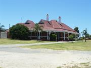
517 Great Eastern Hwy Redcliffe
Dear Brutas
Belmont
Metropolitan
Constructed from 1906
| Type | Status | Date | Documents |
|---|---|---|---|
| Heritage List | Adopted | 27 Jun 2023 | |
| Heritage List | Removed | 31 Dec 1996 | |
| State Register | Registered | 23 Nov 2001 | HCWebsite.Listing+ListingDocument, HCWebsite.Listing+ListingDocument |
| Type | Status | Date | Documents |
|---|---|---|---|
| (no listings) |
| Type | Status | Date | Grading/Management | |
|---|---|---|---|---|
| Category | ||||
| Municipal Inventory | Removed | 22 Nov 2016 | Category 1 | |
| Municipal Inventory | Removed | 31 Dec 1996 | Category 1 | |
| Library Id | Title | Medium | Year Of Publication |
|---|---|---|---|
| 6843 | Tampina, Redcliffe, Western Australia : conservation plan. | Heritage Study {Cons'n Plan} | 2004 |
| 9531 | Swan and Helena rivers management framework: heritage audit and statement of significance, final report 26 February 2009. | Heritage Study {Other} | 2009 |
| 9530 | Swan and Helena rivers regional recreational path development plan. | Report | 2009 |
Individual Building or Group
| Epoch | General | Specific |
|---|---|---|
| Other Use | MILITARY | Office or Administration Bldg |
| Other Use | SOCIAL\RECREATIONAL | Other Sports Building |
| Original Use | RESIDENTIAL | Single storey residence |
| Other Use | RESIDENTIAL | Institutional Housing |
| Present Use | COMMERCIAL | Office or Administration Bldg |
| Style |
|---|
| Federation Queen Anne |
| Type | General | Specific |
|---|---|---|
| Wall | BRICK | Common Brick |
| Roof | METAL | Corrugated Iron |
| General | Specific |
|---|---|
| OCCUPATIONS | Domestic activities |
| SOCIAL & CIVIC ACTIVITIES | Sport, recreation & entertainment |
| OUTSIDE INFLUENCES | World Wars & other wars |
This information is provided voluntarily as a public service. The information provided is made available in good faith and is derived from sources believed to be reliable and accurate. However, the information is provided solely on the basis that readers will be responsible for making their own assessment of the matters discussed herein and are advised to verify all relevant representations, statements and information.
Constructed from 1904
Tampina, a single-storey brick and iron residence constructed c.1906 in the Federation Queen Anne style, has cultural heritage significance for the following reasons: • The place has historic value as the construction of the place was as a direct result of the growth and development of the horse racing industry in Perth and in Belmont in particular in the 1890s and early 1900s; • the place displays aesthetic qualities characteristic of the Federation period and exhibits some fine decorative design detailing, particularly the joinery, tuck-pointing and richly varied roof form • the place has social value for its: o associations with the horse racing industry and prominent racing identity, J. F. G. Robinson;associations with the RAAF during World War Two, and o use as a hostel for mentally and physically disabled children. • the place contributes to the local community’s sense of place as one of the few large residences remaining from the turn of the century development of the Redcliffe/Belmont area.
Tampina is a single-storey brick building with a corrugated iron roof. The former house now provides office accommodation and is located in a light industrial area in Redcliffe. The building is enclosed with metal fencing and a modest garden of grass. There are a few mature trees located between the fence and the main elevation. Constructed in the Federation Queen Anne style, the place has a U-shaped plan form. Verandahs are evident on the north and west elevations and also along the rear elevation providing covered access to the building. A flat metal deck roof extends from this rear verandah over land to the south of the building to provide undercover parking. The roof is constructed with a lower pitch over the verandahs. Two half-gabled forms of equal size and with timber louvred vents are a prominent feature in the principal elevation facing Great Eastern Highway. Three tall brick chimneys with tuck-pointing, rendered corbelling and terracotta pots rise above the roof providing interest along the skyline while less ornamental stacks punctuate the rear roof. Timber posts supporting the verandah eaves have been carefully detailed and retain evidence of former attachments. Arched timber valances span between the front and side verandah posts. Scrolled rendered mouldings are evident under the projecting sills of the windows of the principal elevation. Heads of the windows at the south-east corner of the building feature arches formed with three soldier courses. Elsewhere, window heads are flat and defined by bands of render. Windows are of timber framed construction and mostly with double hung sashes.
The land on which this former residence is located was purchased by horse trainer Ernest Birchall McKeon (1872-1955) in 1903. A newspaper article in 1945 stated that McKeon built this house and the stables. No detail of the architect or builder has been found in this, or previous research however it is possible that an advertisement in March 1905 by architect Augustus Reiusset was for this house. The tender to builders was for the construction of a brick bungalow on Guildford Road, Belmont. At that time Reiusset was a resident of Belmont Park and a member of the Belmont Board of Health. It is likely that McKeon fell on hard times as the property was purchased by pastoralist John Frederick Gary Robinson (1864-1947) in 1908. Robinson stated that he was 'fortunate enough to buy the best stables in the state at a bargain'. Robinson named the house Tampina and lived there with his wife Elsie Sarah Coppin (1874-1954) and their five children. Robinson was a succesful pastorialist with stations in the Pilbara region of the state. The couple married in Marble Bar and relocated to Perth c1904. Robinson regularly visited his station properties but was able to pursue his interest in horse breeding and racing at this property. John Robinson was elected to the Belmont Road Board in 1910, as one of two representatives for the newly created East Ward. Tampina was occupied by the RAAF during World War Two, as the operation centre for a nearby aerodrome. After the war the place was transferred to Dorothy Marian Scherini (c1894-1981) a horse owner and taxi proprietor. She named the house 'Dear Brutus' or 'Brutus Lodge' in honour of one of her successful track horses. In 1948, the property was resurveyed and the stables and house were on separate lots. The property transferred a number of times to private owners, most had some connection to the horse racing industry. Between 1956 and 1965, the place was used as a hostel for mentally and physically disabled children and was altered internally for that purpose. This was the same organisation (later Nulsen Haven) which occupied 'Wedderburn' futher east on Great Eastern Highway in Redcliffe. Tampina was transferred to the current owners in 1964 and is used as offices. The stables were demolished in the 1980s.
Integrity: Moderate Authenticity: High
Good
| Reserve | Lot/Location | Plan/Diagram | Vol/Folio |
|---|---|---|---|
| 2 |
This information is provided voluntarily as a public service. The information provided is made available in good faith and is derived from sources believed to be reliable and accurate. However, the information is provided solely on the basis that readers will be responsible for making their own assessment of the matters discussed herein and are advised to verify all relevant representations, statements and information.

14 Miller Ave Redcliffe
Belmont
Metropolitan
Constructed from 1947
| Type | Status | Date | Documents |
|---|---|---|---|
| (no listings) |
| Type | Status | Date | Documents |
|---|---|---|---|
| RHP - Does not warrant assessment | Current | 25 Jul 2014 |
| Type | Status | Date | Grading/Management | |
|---|---|---|---|---|
| Category | ||||
| (no listings) | ||||
The house represents the provision of government subsidised housing by the State after World War Two, and is indicative of the standard plan and type of housing constructed by the State Government in the twentieth-century.
House, 14 Miller Avenue, Redcliffe is a single detached brick and tile dwelling comprising three bedrooms, including a sleepout, one bathroom, lounge, kitchen, laundry and water closet, and enclosed rear verandah. The rear yard is divided in two by a small fence, and includes a large garage and four other structures, roofed in corrugated iron.
House, 14 Miller Avenue, Redcliffe was constructed in 1947 to the standard B2/22A Brick Type model, as provided in the (undated) House Designs Booklet circulated by the State Housing Commission of Western Australia. It has remained in the property of the Western Australian government, now the Department of Housing up to 2014.
Individual Building or Group
| Epoch | General | Specific |
|---|---|---|
| Present Use | VACANT\UNUSED | Vacant\Unused |
| Original Use | RESIDENTIAL | Single storey residence |
| Style |
|---|
| Vernacular |
| Type | General | Specific |
|---|---|---|
| Roof | TILE | Other Tile |
| Wall | BRICK | Common Brick |
This information is provided voluntarily as a public service. The information provided is made available in good faith and is derived from sources believed to be reliable and accurate. However, the information is provided solely on the basis that readers will be responsible for making their own assessment of the matters discussed herein and are advised to verify all relevant representations, statements and information.