Local Government
Belmont
Region
Metropolitan
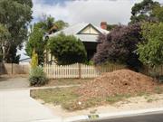
14 Kooyong Road Rivervale
Lot 277, P1711
Belmont
Metropolitan
| Type | Status | Date | Documents |
|---|---|---|---|
| (no listings) |
| Type | Status | Date | Documents |
|---|---|---|---|
| (no listings) |
| Type | Status | Date | Grading/Management | |
|---|---|---|---|---|
| Category | ||||
| Local Heritage Survey | Adopted | 27 Jun 2023 | Category 3 | |
Individual Building or Group
| Epoch | General | Specific |
|---|---|---|
| Original Use | RESIDENTIAL | Single storey residence |
| Style |
|---|
| Inter-War California Bungalow |
| General | Specific |
|---|---|
| DEMOGRAPHIC SETTLEMENT & MOBILITY | Settlements |
This information is provided voluntarily as a public service. The information provided is made available in good faith and is derived from sources believed to be reliable and accurate. However, the information is provided solely on the basis that readers will be responsible for making their own assessment of the matters discussed herein and are advised to verify all relevant representations, statements and information.
Constructed from 1930
• As a good representative example of the standard of modest rental accommodation built for people such as tradesmen, junior employees, labourers and single women/widows in Rivervale during the Inter War period. • As a good representative example of the application of materials and detailing which were derived from the Calfornian Bungalow style, but which were applied in a restrained manner that suited the budgets and expectations of working families in Belmont during the Inter-War era. • The cottage has aesthetic and social value for its contribution to the sense of place in the residential streetscape.
One of three cottages on the south side of Kooyong Road that have a similarity of age, materials and style. No. 14 has an asymmetrical façade behind a full width verandah. The roof is hipped and gabled, clad with corrugated metal sheeting, continuing down at a break of pitch to form the verandah canopy, supported on square timber posts. The deck is timber. The entrance is on the shallow return to the projecting section of the elevation. Windows are traditional timber framed four-section casement openings with toplights.
This area of Rivervale, or South Belmont as it was then known, was subdivided in 1897 but there was little residential development until the Inter War period. Prior to this, the area was sparsely settled for farming and horse racing activities. During this gold boom period there was considerable subdivision in metropolitan Perth by investors. After World War One, the population increased with returned servicemen and migrants from Britain seeking new homes and a fresh start. The Workers Home Board (precursor to the State Housing Commission) were active in the district, building the modest timber homes from their catalogue of standard plans. It has not been established when all three house were constructed. It is possible the houses were built as investment properties and rented to tenants. It is proposed that the three houses were built in the early 1930s and the style of house is consistent with that period. In 1930, a notice in the Sunday Times listed many properties in the Belmont Park Road Board where the owners had not paid rates leading to the acquisition of these properties by the Road Board. The lots on which these three houses are located were not included but others nearby were, and all were vacant land suggesting the area was sparsely developed.
Integrity: High Authenticity: High
Good
| Ref ID No | Ref Name | Ref Source | Ref Date |
|---|---|---|---|
| The Sunday Times pg. 1 | 26 Jan 1930 | ||
| The West Australian pg. 2 | 27 May 1931 | ||
| The West Australian pg. 2 | 2 November 1927 | ||
| Maxine Laurie 'Ever Flowing Forward The Story of Belmont' | City of Belmont | 1999 | |
| Landgate Aerial photographs | 1953-2016 | ||
| City of Belmont (Heritage) Inventory | 2016 |
This information is provided voluntarily as a public service. The information provided is made available in good faith and is derived from sources believed to be reliable and accurate. However, the information is provided solely on the basis that readers will be responsible for making their own assessment of the matters discussed herein and are advised to verify all relevant representations, statements and information.
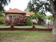
16 Kooyong Road Rivervale
Lot 278, P1711
Belmont
Metropolitan
| Type | Status | Date | Documents |
|---|---|---|---|
| (no listings) |
| Type | Status | Date | Documents |
|---|---|---|---|
| (no listings) |
| Type | Status | Date | Grading/Management | |
|---|---|---|---|---|
| Category | ||||
| Local Heritage Survey | Adopted | 27 Jun 2023 | Category 3 | |
Individual Building or Group
| Epoch | General | Specific |
|---|---|---|
| Original Use | RESIDENTIAL | Single storey residence |
| Style |
|---|
| Inter-War California Bungalow |
| Type | General | Specific |
|---|---|---|
| Wall | TIMBER | Weatherboard |
| General | Specific |
|---|---|
| DEMOGRAPHIC SETTLEMENT & MOBILITY | Settlements |
This information is provided voluntarily as a public service. The information provided is made available in good faith and is derived from sources believed to be reliable and accurate. However, the information is provided solely on the basis that readers will be responsible for making their own assessment of the matters discussed herein and are advised to verify all relevant representations, statements and information.
Constructed from 1931
• As a good representative example of the standard of modest rental accommodation built for people such as tradesmen, junior employees, labourers and single women/widows in Rivervale during the Inter War period. • As a good representative example of the application of materials and detailing which were derived from the Calfornian Bungalow style, but which were applied in a restrained manner that suited the budgets and expectations of working families in Belmont during the Inter-War era. • The cottage has aesthetic and social value for its contribution to the sense of place in the residential streetscape.
One of three cottages on the south side of Kooyong Road that have a similarity of age, materials and style. No. 16 has a simple symmetrical presentation. The central entrance is a single door without fanlight or side panels. The flanking windows are three-sectioned openings, each comprising a larger central panel flanked by sash windows, 2-over-1 style. The verandah is enclosed by timber balustrade with non-original brick piers.
This area of Rivervale, or South Belmont as it was then known, was subdivided in 1897 but there was little residential development until the Inter War period. Prior to this, the area was sparsely settled for farming and horse racing activities. During this gold boom period there was considerable subdivision in metropolitan Perth by investors. After World War One, the population increased with returned servicemen and migrants from Britain seeking new homes and a fresh start. The Workers Home Board (precursor to the State Housing Commission) were active in the district, building the modest timber homes from their catalogue of standard plans. It is proposed that this house and those adjacent at 14 and 18 Kooyong Road were built in the early 1930s and the style of house is consistent with that period. In 1930, a notice in the Sunday Times listed many properties in the Belmont Park Road Board where the owners had not paid rates leading to the acquisition of these properties by the Road Board. The lots on which these three houses are located were not included but others nearby were, and all were vacant land suggesting the area was sparsely developed. A sewerage plan of the area prepared by the Metropolitan Water Supply and Drainage Department in 1939 shows all three houses present with similar housing on the north and south sides of Kooyong Road. This plan also shows that many houses had substantial stables behind the houses.
Integrity: High Authenticity: High
Good
| Ref ID No | Ref Name | Ref Source | Ref Date |
|---|---|---|---|
| The West Australian pg. 2 | 27 May 1931 | ||
| The Sunday Times pg. 1 | 26 Jan 1930 | ||
| City of Belmont (Heritage) Inventory | 2016 | ||
| The West Australian pg. 2 | 2 November 1927 | ||
| Maxine Laurie 'Ever Flowing Forward The Story of Belmont' | City of Belmont | 1999 | |
| Landgate Aerial photographs | 1953-2016 |
This information is provided voluntarily as a public service. The information provided is made available in good faith and is derived from sources believed to be reliable and accurate. However, the information is provided solely on the basis that readers will be responsible for making their own assessment of the matters discussed herein and are advised to verify all relevant representations, statements and information.
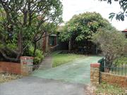
18 Kooyong Road Rivervale
Lot 279, P1711
Belmont
Metropolitan
| Type | Status | Date | Documents |
|---|---|---|---|
| (no listings) |
| Type | Status | Date | Documents |
|---|---|---|---|
| (no listings) |
| Type | Status | Date | Grading/Management | |
|---|---|---|---|---|
| Category | ||||
| Local Heritage Survey | Adopted | 27 Jun 2023 | Category 3 | |
Individual Building or Group
| Epoch | General | Specific |
|---|---|---|
| Original Use | RESIDENTIAL | Single storey residence |
| Style |
|---|
| Inter-War California Bungalow |
| Type | General | Specific |
|---|---|---|
| Wall | TIMBER | Weatherboard |
| General | Specific |
|---|---|
| DEMOGRAPHIC SETTLEMENT & MOBILITY | Settlements |
This information is provided voluntarily as a public service. The information provided is made available in good faith and is derived from sources believed to be reliable and accurate. However, the information is provided solely on the basis that readers will be responsible for making their own assessment of the matters discussed herein and are advised to verify all relevant representations, statements and information.
Constructed from 1931
• As a good representative example of the standard of modest rental accommodation built for people such as tradesmen, junior employees, labourers and single women/widows in Rivervale during the Inter War period. • As a good representative example of the application of materials and detailing which were derived from the Calfornian Bungalow style, but which were applied in a restrained manner that suited the budgets and expectations of working families in Belmont during the Inter-War era. • The cottage has aesthetic and social value for its contribution to the sense of place in the residential streetscape.
One of three cottages on the south side of Kooyong Road that have a similarity of age, materials and style. No. 18 is an asymmetric timber framed house with hipped and gable roof. The roof over the main section of the house is hipped which extends down with a break of pitch to form the verandah canopy. The gable roof sits over the projecting section of the façade and verandah extends across the full width of the façade, supported on square timber posts. The entrance is on the return of the projecting section. The windows are three section timber framed windows, with a fixed central pane flanked by small paned casements. The gable is clad with fibre cement sheeting and weatherboards.
This area of Rivervale, or South Belmont as it was then known, was subdivided in 1897 but there was little residential development until the Inter War period. Prior to this, the area was sparsely settled for farming and horse racing activities. During this gold boom period there was considerable subdivision in metropolitan Perth by investors. After World War One, the population increased with returned servicemen and migrants from Britain seeking new homes and a fresh start. The Workers Home Board (precursor to the State Housing Commission) were active in the district, building the modest timber homes from their catalogue of standard plans. It is proposed that this house and those adjacent at 14 and 16 Kooyong Road were built in the early 1930s and the style of house is consistent with that period. In 1930, a notice in the Sunday Times listed many properties in the Belmont Park Road Board where the owners had not paid rates leading to the acquisition of these properties by the Road Board. The lots on which these three houses are located were not included but others nearby were, and all were vacant land suggesting the area was sparsely developed.
Integrity: High Authenticity: High
Good
| Ref ID No | Ref Name | Ref Source | Ref Date |
|---|---|---|---|
| The West Australian pg. 28 | 2 November 1927 | ||
| The Sunday Times pg. 1 | 26 Jan 1930 | ||
| The West Australian pg. 2 | 27 May 1931 | ||
| Maxine Laurie 'Ever Flowing Forward The Story of Belmont' | City of Belmont | 1999 | |
| City of Belmont (Heritage) Inventory | 2016 | ||
| Landgate Aerial photographs | 1953-2016 |
This information is provided voluntarily as a public service. The information provided is made available in good faith and is derived from sources believed to be reliable and accurate. However, the information is provided solely on the basis that readers will be responsible for making their own assessment of the matters discussed herein and are advised to verify all relevant representations, statements and information.
8 Malvern Rd Rivervale
Belmont
Metropolitan
| Type | Status | Date | Documents |
|---|---|---|---|
| (no listings) |
| Type | Status | Date | Documents |
|---|---|---|---|
| (no listings) |
| Type | Status | Date | Grading/Management | |
|---|---|---|---|---|
| Category | ||||
| Classified by the National Trust | Recorded | |||
Tree
| Epoch | General | Specific |
|---|---|---|
| Present Use | OTHER | Other |
| Original Use | OTHER | Other |
This information is provided voluntarily as a public service. The information provided is made available in good faith and is derived from sources believed to be reliable and accurate. However, the information is provided solely on the basis that readers will be responsible for making their own assessment of the matters discussed herein and are advised to verify all relevant representations, statements and information.
237-239 Orrong Road Rivervale
Belmont
Metropolitan
Constructed from 1970 to 1971
| Type | Status | Date | Documents |
|---|---|---|---|
| (no listings) |
| Type | Status | Date | Documents |
|---|---|---|---|
| (no listings) |
| Type | Status | Date | Grading/Management | |
|---|---|---|---|---|
| Category | ||||
| Anglican Church Inventory | YES | 31 Jul 1996 | ||
Individual Building or Group
| Epoch | General | Specific |
|---|---|---|
| Original Use | RELIGIOUS | Housing or Quarters |
| Present Use | RELIGIOUS | Church, Cathedral or Chapel |
| Present Use | RELIGIOUS | Housing or Quarters |
| Original Use | RELIGIOUS | Church, Cathedral or Chapel |
| Type | General | Specific |
|---|---|---|
| Wall | BRICK | Common Brick |
| Roof | ASBESTOS | Fibrous Cement, corrugated |
| General | Specific |
|---|---|
| SOCIAL & CIVIC ACTIVITIES | Religion |
This information is provided voluntarily as a public service. The information provided is made available in good faith and is derived from sources believed to be reliable and accurate. However, the information is provided solely on the basis that readers will be responsible for making their own assessment of the matters discussed herein and are advised to verify all relevant representations, statements and information.
48 Riversdale Rd Rivervale
Lot 29
Homelea, St Columban's
Riversdale
Belmont
Metropolitan
Constructed from 1903
| Type | Status | Date | Documents |
|---|---|---|---|
| Heritage List | Removed | 31 Dec 1996 |
| Type | Status | Date | Documents |
|---|---|---|---|
| RHP - Assessed - Below Threshold | Current | 11 Aug 2006 |
| Type | Status | Date | Grading/Management | |
|---|---|---|---|---|
| Category | ||||
| Municipal Inventory | Removed | 22 Nov 2016 | Category 3 | |
| Local Heritage Survey | Adopted | 27 Jun 2023 | Category 4 | |
| Municipal Inventory | Removed | 31 Dec 1996 | Category 3 | |
good
| Library Id | Title | Medium | Year Of Publication |
|---|---|---|---|
| 7782 | House, 48 Riversdale Road, Rivervale, Western Australia: draft assessment of cultural heritage significance. | Heritage Study {Other} | 2005 |
| 7783 | House, 48 Riversdale Road, Rivervale, Western Australia: archival record. | Archival Record | 2005 |
Individual Building or Group
| Epoch | General | Specific |
|---|---|---|
| Present Use | RELIGIOUS | Monastery or Convent |
| Original Use | EDUCATIONAL | Other |
| Other Use | EDUCATIONAL | Housing or Quarters |
| Original Use | RESIDENTIAL | Single storey residence |
| Original Use | HEALTH | Hospital |
| Style |
|---|
| Federation Free Classical |
| Type | General | Specific |
|---|---|---|
| Wall | BRICK | Painted Brick |
| Roof | METAL | Corrugated Iron |
| General | Specific |
|---|---|
| SOCIAL & CIVIC ACTIVITIES | Community services & utilities |
| OCCUPATIONS | Domestic activities |
| SOCIAL & CIVIC ACTIVITIES | Religion |
This information is provided voluntarily as a public service. The information provided is made available in good faith and is derived from sources believed to be reliable and accurate. However, the information is provided solely on the basis that readers will be responsible for making their own assessment of the matters discussed herein and are advised to verify all relevant representations, statements and information.
Constructed from 1906
• The site has historic value for its association with the development of the Belmont community in the 1920s as exhibited through the decision to build a community hall. • The site has social value for the members of the Belmont community who remember it at this site until its demolition in 2004.
There is no evidence of the former hall on the site.
The opening ceremony of the Riversdale Hall took place on February 22, 1919 at 3 pm by the Hon. R.T. Robinson M.L.A. The Chairman of the Committee was Mr H.G. Duncan and the Secretary Mr W. Newey. This was followed by a Concert at 8pm and dancing at 9.30pm. The Hall was built by the efforts of the dedicated local citizens, particularly the Newey family. This group of citizens called themselves ‘The Riversdale Progress Association’. Some of the first motion pictures were shown here and the ‘Belmont Young Men’s Association’ met here every Friday night for gymnastics. Unfortunately, the Road Board had not seen fit to take over the control of the Hall, which was heavily mortgaged. When the depression of the late 1920’s and early 1930’s arrived, the payments could not be met, resulting in the Hall being sold. The establishment then became a billiard saloon. At the conclusion of the Second World War, the Hall returned to its original use - a picture theatre. This was the district’s only picture theatre. A brick entry and projection box was added to the front of the building. Later, theatre gardens were added to the side of the building and greatly enjoyed in the warm weather. The coming of television saw the demise of many of these attractions in the metropolitan area. This building was used for commercial purposes until it was demolished in 2004.
Integrity: N/A Authenticity: N/A
N/A
| Reserve | Lot/Location | Plan/Diagram | Vol/Folio |
|---|---|---|---|
| 29 | 1638 |
This information is provided voluntarily as a public service. The information provided is made available in good faith and is derived from sources believed to be reliable and accurate. However, the information is provided solely on the basis that readers will be responsible for making their own assessment of the matters discussed herein and are advised to verify all relevant representations, statements and information.
52-54 Riversdale Rd Rivervale
Hawksburn Road Swimming Baths
The Springs/Riversdale Baths
Belmont
Metropolitan
| Type | Status | Date | Documents |
|---|---|---|---|
| Heritage List | Removed | 31 Dec 1996 |
| Type | Status | Date | Documents |
|---|---|---|---|
| (no listings) |
| Type | Status | Date | Grading/Management | |
|---|---|---|---|---|
| Category | ||||
| Municipal Inventory | Removed | 31 Dec 1996 | Category 4 | |
| Local Heritage Survey | Adopted | 27 Jun 2023 | Category 3 | |
| Municipal Inventory | Removed | 22 Nov 2016 | Category 4 | |
Historic Site
| Epoch | General | Specific |
|---|---|---|
| Original Use | SOCIAL\RECREATIONAL | Other |
| Present Use | SOCIAL\RECREATIONAL | Other |
| General | Specific |
|---|---|
| SOCIAL & CIVIC ACTIVITIES | Community services & utilities |
This information is provided voluntarily as a public service. The information provided is made available in good faith and is derived from sources believed to be reliable and accurate. However, the information is provided solely on the basis that readers will be responsible for making their own assessment of the matters discussed herein and are advised to verify all relevant representations, statements and information.
• The place has aesthetic value for its combination of mature trees and well maintained parkland adjacent to the river. • The place has historic value for its association with the early forms of public recreation and organised sports using public facilities. • The place has social value for its association with the past use of the site for the local swimming, scout and rowing clubs and its continued use for passive recreation.
A city park located on the southern banks of the Swan River incorporating a riparian landscape, children’s play area, grassed areas, seating and terraces leading down to the river. Typical park environment with mix of hard and soft landscaping elements populated with native plantings. There are pathways that lead down to the river and a small jetty.
This local bathing centre is referred to as ‘The Springs’ because of its natural formulation at the riverside. In many local government documents the site is also known as the Hawksburn Road Swimming Baths and Riversdale Baths. ‘The Springs’ had always been a popular bathing site for the people of Belmont and Victoria Park, as the Minutes of the Road Board meeting of December 15, 1903 document. The site served as a popular bathing place well before the turn of the century. At the meeting, the proposal for the erection of bathing sheds was announced, this request was granted on 4 February 1907, and the construction of the sheds was to be the financial responsibility of the Burswood Progress Association. The Minutes of the BRB meeting of January 15,1912 document that some difficulty in the fund raising pursuits of the Progress Association led the Board to take on the bathing shed issue, with the maximum allocation of 50 Pounds set aside for this specific purpose. When tenders were called in late January 1912, only a single application was received. Unimpressed, the Board encouraged one of their employees, McCracken , to take on the task of constructing the sheds. Presumably, the shed was completed in time for the Burswood Swimming Club’s carnival held on March 2, 1912. During World War I, the area served as a social centre, playing host to various picnics, regattas, swimming clubs and competitions. Special distance markers for swimmers (consisting of spaced poles embedded into the mud bottom of the river) had been constructed in 1919 and the area was partially sectioned off by a makeshift jetty. As the place became a frequented venue for sporting and social events, the change sheds were updated and a proper path to the swimming area was laid. The Minutes of a Road Board meeting of 6 October 1919, document that a petition was presented requesting that the Board purchase the land adjoining Hawksburn Road and Riversdale Road to improve the bathing place and assist the new cricket club in finding a ground. Mr Newey spoke of the matter on behalf of the Belmont’s Young Men’s Club who were officially the owners of the land. The Club had acquired the land cheaply, early in 1919, and had been intent on developing it as a major metropolitan swimming site. The club found it difficult to raise funds to maintain the venue, and so by 1927, the Belmont Young Men’s Club transferred the land permanently into the hands of the Belmont Park Road Board. The Club stipulated one condition to the Board, that being, that the land be maintained exclusively for recreation purposes. During the 1920’s and 1930’s, ‘The Springs’ was a popular site for rowing competitions and regattas, many of which were sponsored by local Progress Association. The Riversdale Progress Association donated funds towards the staging of regattas at ‘The Springs’, as well as a clean-up of the facilities. ‘The Springs’ was also a place of some renown for local Scouts who frequented the area as the starting point for their annual Swan tikis. The Road Board began to update the facilities rather substantially by the 1930’s. The documents and Minutes of the Board meetings determine that by June 30, 1931 the land on the foreshore had been levelled, cleaned and listed as the newly constructed Riversdale Park. In addition, new swimming lanes were constructed in 1938 and an additional jetty added in 1955, in order to assist the Belmont Swimming Club, which conducted frequent competitions and carnivals at ‘The Springs’. By December 18, 1964 ‘The Springs’ reserve had been fully reticulated and at a Board meeting on April 10, 1964 it was resolved to change the title of the reserve to Cracknell Park. The proclamation of Cracknell Park was in honour of a local family, specifically Ronald Frederick William Cracknell (c1906-1981) who served on the Belmont Road Board. Cycle ways were added during 1974 / 75 (Minutes of Shire, November 1974 to July 1975), for more contemporary sporting enthusiasts and are now linked to a system of cycle tracks along the Swan River. The park continues to be popular for the community of Belmont and the wider metropolitan community.
Integrity: N/A Authenticity: N/A
Good
| Reserve | Lot/Location | Plan/Diagram | Vol/Folio |
|---|---|---|---|
| 27 & 28 | 1638 | 130/Folio117 |
This information is provided voluntarily as a public service. The information provided is made available in good faith and is derived from sources believed to be reliable and accurate. However, the information is provided solely on the basis that readers will be responsible for making their own assessment of the matters discussed herein and are advised to verify all relevant representations, statements and information.
60 Riversdale Rd Rivervale
MI notes place as 60-62 Riversdale Road, Rivervale
Shortland-Jones Home
Belmont
Metropolitan
Constructed from 1906
| Type | Status | Date | Documents |
|---|---|---|---|
| Heritage List | Removed | 31 Dec 1996 |
| Type | Status | Date | Documents |
|---|---|---|---|
| (no listings) |
| Type | Status | Date | Grading/Management | |
|---|---|---|---|---|
| Category | ||||
| Municipal Inventory | Removed | 31 Dec 1996 | Category 4 | |
| Municipal Inventory | Removed | 22 Nov 2016 | Category 4 | |
| Local Heritage Survey | Adopted | 27 Jun 2023 | Category 4 | |
Historic site
| Epoch | General | Specific |
|---|---|---|
| Original Use | RESIDENTIAL | Single storey residence |
| Present Use | RESIDENTIAL | Single storey residence |
| Type | General | Specific |
|---|---|---|
| Roof | TILE | Other Tile |
| Wall | BRICK | Common Brick |
| General | Specific |
|---|---|
| PEOPLE | Early settlers |
This information is provided voluntarily as a public service. The information provided is made available in good faith and is derived from sources believed to be reliable and accurate. However, the information is provided solely on the basis that readers will be responsible for making their own assessment of the matters discussed herein and are advised to verify all relevant representations, statements and information.
Constructed from 1906
• The site is association with the early development of this area Belmont by the members of the well known and professional groups in Perth during the early 20th century. • The names associated with this former building have been recognised in adjacent subdivisions demonstrating the ongoing social value of the site.
N/A
The house was built by Sammy Rowe, a Coolgardie glass and timber merchant. It was constructed around 1906 for the Shortland- Jones family. Mr Fred Shortland-Jones was an engineering surveyor in the Railway Department’s main office in Wellington Street, Perth. The house had a large billiard room, a music room, two large bedrooms, a dining room, kitchen, bathroom and a laundry attached to the back. Most rooms had fireplaces with detailed carved wooden surrounds. The block of land extended to the river’s foreshore and there was a small jetty and a large shed to house the family yacht. The Shortland-Jones family left in 1940. The place was demolished in 2009.
Integrity: N/A Authenticity: N/A
Good
| Reserve | Lot/Location | Plan/Diagram | Vol/Folio |
|---|---|---|---|
| 603 | 94929 |
This information is provided voluntarily as a public service. The information provided is made available in good faith and is derived from sources believed to be reliable and accurate. However, the information is provided solely on the basis that readers will be responsible for making their own assessment of the matters discussed herein and are advised to verify all relevant representations, statements and information.
67 Riversdale Rd Rivervale
The Taylor Place
Belmont
Metropolitan
Constructed from 1938
| Type | Status | Date | Documents |
|---|---|---|---|
| Heritage List | Removed | 17 Feb 2003 |
| Type | Status | Date | Documents |
|---|---|---|---|
| (no listings) |
| Type | Status | Date | Grading/Management | |
|---|---|---|---|---|
| Category | ||||
| Municipal Inventory | Removed | 22 Nov 2016 | Category 2 | |
| Municipal Inventory | Removed | 17 Feb 2003 | Category 2 | |
| Local Heritage Survey | Adopted | 27 Jun 2023 | Category 2 | |
Individual Building or Group
| Epoch | General | Specific |
|---|---|---|
| Original Use | RESIDENTIAL | One-and-a-half storey residence |
| Present Use | RESIDENTIAL | One-and-a-half storey residence |
| Type | General | Specific |
|---|---|---|
| Other | BRICK | Other Brick |
| General | Specific |
|---|---|
| PEOPLE | Local heroes & battlers |
This information is provided voluntarily as a public service. The information provided is made available in good faith and is derived from sources believed to be reliable and accurate. However, the information is provided solely on the basis that readers will be responsible for making their own assessment of the matters discussed herein and are advised to verify all relevant representations, statements and information.
Constructed from 1938, Constructed from 1939
• The Taylor Place is valued as a landmark in the area because of its prominent location and longevity in the streetscape. • The place has aesthetic value as a example of simplified Interwar Old English Style • The site has historic value for its association with the development of this area of Belmont for professional men and their families.
Interwar Old English style house of brick construction with steep pitched and gabled tile roof. A tall brick chimney extends up the east elevation of the house. The house is two storey with the upper level accommodation mainly within the roof space. The lower section of the house is of face brick construction with rendered gables and dormer to the upper level. The main gable incorporates french doors and a juliet style balcony. The lower level incorporates small bay windows with textured blockwork and faceted hipped roofs. Doors are timber framed and with glazing. Each glass panel is divided into five horizontal panes.
The land on which The Taylor Place is sited was owned by highly regarded soldier, and later Commissioner of WA Railways, Col. Harold Pope until 1936 (Daily News, 13 May 1938). Subsequently it was transferred to internationally famous jockey Albert Sibbiritt (West Australian, 13 February 1947). Sibbritt appears to have commenced construction of a property on Riversdale Road, but did not complete it before selling the land to John Robert Hallam, a car dealer, on 22 September 1939. Hallam ran Perth Car Sales (also known as Milligan Car Sales), Milligan Street, Perth. Hallam, a widower, moved to the house with his three daughters. His son, John ‘Jack’ Hallam was overseas serving with the Air Force. Hallam’s daughter, Veronica, married Clarence Sydney Taylor, a car dealer, in July 1942, and the couple lived at The Taylor Place. After his remarriage in 1947, Hallam Snr relocated to 44 Riverdale Road, while the Taylor family, now with children, continued to reside at The Taylor Place. The property was finally transferred to Veronica Daphne Taylor on 16 February 1954. The house was sold to Philip Arthur Watkins and Evelyn Felicia Vicker on 19 March 1985, and to Kevin Michael Tavener and Evelyn Felicia Vicker on 21 October 1994. The place continues to be used as a private residence.
Integrity: High Authenticity: High
Good
| Reserve | Lot/Location | Plan/Diagram | Vol/Folio |
|---|---|---|---|
| 134 | 1638 |
This information is provided voluntarily as a public service. The information provided is made available in good faith and is derived from sources believed to be reliable and accurate. However, the information is provided solely on the basis that readers will be responsible for making their own assessment of the matters discussed herein and are advised to verify all relevant representations, statements and information.
Road Reserve, Hawksburn Rd Rivervale
Belmont
Metropolitan
| Type | Status | Date | Documents |
|---|---|---|---|
| Heritage List | Removed | 17 Apr 2003 |
| Type | Status | Date | Documents |
|---|---|---|---|
| RHP - Does not warrant assessment | Current | 30 Oct 2009 |
| Type | Status | Date | Grading/Management | |
|---|---|---|---|---|
| Category | ||||
| Local Heritage Survey | Adopted | 27 Jun 2023 | Category 3 | |
| Municipal Inventory | Removed | 22 Nov 2016 | Category 1 | |
| Municipal Inventory | Removed | 17 Apr 2003 | Category 1 | |
Tree
| Epoch | General | Specific |
|---|---|---|
| Present Use | OTHER | Other |
| Original Use | OTHER | Other |
| General | Specific |
|---|---|
| SOCIAL & CIVIC ACTIVITIES | Cultural activities |
This information is provided voluntarily as a public service. The information provided is made available in good faith and is derived from sources believed to be reliable and accurate. However, the information is provided solely on the basis that readers will be responsible for making their own assessment of the matters discussed herein and are advised to verify all relevant representations, statements and information.
• The avenue of trees make a positive contribution to the streetscape and are a well known landmark in the district. • The trees have historic value for its association with the Belmont Young Men's Club who were motivated to provide services for the club and community.
The avenue of mature trees are a prominent element in the urbanised streetscape.
The Belmont Young Men's Club was formed in 1919 and they purchased some land at the end of Hawksburn Road, Rivervale, known as "The Springs". They intended developing this site into a major swimming and rowing venue, but were unable to raise the funds. In 1926, they presented the land to the Belmont Road Board on condition it be reserved for public use. The flame trees along Hawksburn Road were planted by the members of this Club, possibly as an entry to their planned venue.
Integrity: High Authenticity: High
Good
This information is provided voluntarily as a public service. The information provided is made available in good faith and is derived from sources believed to be reliable and accurate. However, the information is provided solely on the basis that readers will be responsible for making their own assessment of the matters discussed herein and are advised to verify all relevant representations, statements and information.
1 Rowe Avenue Rivervale
Lot 99, 153, SP67510, SP73489
Belmont
Metropolitan
| Type | Status | Date | Documents |
|---|---|---|---|
| (no listings) |
| Type | Status | Date | Documents |
|---|---|---|---|
| (no listings) |
| Type | Status | Date | Grading/Management | |
|---|---|---|---|---|
| Category | ||||
| Local Heritage Survey | Adopted | 27 Jun 2023 | Category 4 | |
Tree
| General | Specific |
|---|---|
| DEMOGRAPHIC SETTLEMENT & MOBILITY | Settlements |
This information is provided voluntarily as a public service. The information provided is made available in good faith and is derived from sources believed to be reliable and accurate. However, the information is provided solely on the basis that readers will be responsible for making their own assessment of the matters discussed herein and are advised to verify all relevant representations, statements and information.
Constructed from 1900
The tree is a landmark in the streetscape and an impressive example of the species associated with earlier development of the site.
Mature example of a Moreton Bay fig tree over 50 years old. The tree has now become a focal point of the landscaping around a new higher density residential development which helps break up the built form of the site. A timber walkway has been constructed around the tree together with seating.
This massive tree is visible in a 1953 aerial photograph and the arrangement of the lots at that time placed the tree on the rear boundary. It is not clear whether the tree was intentionally planted at this site or was a self seeded tree. A plan of the locality in 1939 shows that the tree was possibly within the property of 9 Riversdale Road which was the home of fruiterer George Thomas Sherwood. This property had serveral galvanised iron sheds in the rear, as did the adjacent property at 11 Riversdale Road occupied by salesman Watson Brownrigg. These sheds could have been chicken runs or the larger ones used for stables. It is not unreasonable that the tree was planted to provide shade over the sheds. However it is unclear exactly where the base of the tree was located. The lot arrangement of this area has been significantly changed since the original residential subdivision. From the mid 20th century this area took on a mix of light industrial and residential uses prior to multi storey complexes becaming more common toward the late 20th century. . In the period of transition this portion of land appears to have been largely untended and many trees were scattered across the area south of Riversdale Road. In the late 1990s, the Graham Farmer Freeway was constructed on the western boundary of this site and from 2010 onwards land was cleared and new roads constructed. New strata plans were prepared for the two sites on either side of the tree in 2015 and 2020. The retention of this tree is a feature of the new development and its landscaping.
Integrity: N/A Authenticity: N/A
Excellent
| Ref ID No | Ref Name | Ref Source | Ref Date |
|---|---|---|---|
| Landgate - Aerial photographs | 1953-2016 | ||
| Wise's Post Office Directories | 1894-1949 | ||
| Landgate survey information | |||
| Australian Electrial Rolls | 1903-1980 |
This information is provided voluntarily as a public service. The information provided is made available in good faith and is derived from sources believed to be reliable and accurate. However, the information is provided solely on the basis that readers will be responsible for making their own assessment of the matters discussed herein and are advised to verify all relevant representations, statements and information.
15 Salisbury Road Rivervale
Lot 1, D090701
Residence, 15 Salisbury Rd
Belmont
Metropolitan
| Type | Status | Date | Documents |
|---|---|---|---|
| (no listings) |
| Type | Status | Date | Documents |
|---|---|---|---|
| (no listings) |
| Type | Status | Date | Grading/Management | |
|---|---|---|---|---|
| Category | ||||
| Local Heritage Survey | Adopted | 27 Jun 2023 | Category 3 | |
Individual Building or Group
| Epoch | General | Specific |
|---|---|---|
| Original Use | RESIDENTIAL | Single storey residence |
| Style |
|---|
| Inter-War California Bungalow |
| Type | General | Specific |
|---|---|---|
| Roof | TILE | Terracotta Tile |
| Wall | BRICK | Common Brick |
| General | Specific |
|---|---|
| PEOPLE | Local heroes & battlers |
| DEMOGRAPHIC SETTLEMENT & MOBILITY | Settlements |
This information is provided voluntarily as a public service. The information provided is made available in good faith and is derived from sources believed to be reliable and accurate. However, the information is provided solely on the basis that readers will be responsible for making their own assessment of the matters discussed herein and are advised to verify all relevant representations, statements and information.
Constructed from 1936
• The place has aesthetic value as a good representative example of a well designed California Bungalow of the Inter-War era. • The place has historic value for its long term use as the family home of Francis Wilson who made a significant contribution to the City of Belmont as a Councillor, Chairman and President. • The place has social value for its contribution to the community sense of place.
Tuckpointed brick Californian bungalow with render and weatherboard detailing to the elevations and fibre cement sheeting to the gable features. The roof is clad with corrugated zincalume sheeting with tall brick chimneys. Asymmetric in plan form to the façade with a central entrance. One of the projecting bays is of brick construction with rendered bands. The leaded light window is a box bay supported on four decorative brackets. The other wing is an enclosed former verandah with the broad brick and render verandah piers still clearly visible together with the rendered balustrade. Weatherboard has been used to enclose the verandah to create additional internal space. There are three gable roofs, one large gable projecting above the two smaller front gables, each with timbered detailing. The side elevation is painted brick containing an original three section window with corrugated metal canopy.
This house was built in 1936 for Francis (Frank) David Wilson (c1910-1988) and his wife Ellen née Richards (1910-2007). The couple had married in 1931 and lived in Victoria Park and Frank designated his occupation as a labourer. From the available information this house was built in 1935 as the couple were living in the house. Frank Wilson later began a successful career as a bookmaker and between 1944 and 1968 served on the Belmont Road Board, subsequently the Shire of Belmont. He was councillor 1944-68, Road Board Chairman 1946-51, 1955-57 and Shire President 1967-68. In 1988, he was granted the honour of being the First Freeman of the City of Belmont. Frank and Ellen Wilson lived at this house for all their married lives until Frank's death in in 1988. A plan showing the outline of the building in 1939 for the purpose of planning water supply and drainage shows that at that time the house featured an enclosed verandah across the rear of the residence with a laundry and toilet. An asbestos garage was located in the back yard, accessed from Hampden Street. Aerial photographs indicate the lot was subidvided in the late 1990s to enable the construction of a new residence accessed from Hampden Street. The house was originally clad with terracotta tiles and reroofed with zincalume in 2006 and the rear elevation was modified in c2009. These alterations have not impeded the understanding of the original form and extent of the residence.
Integrity: High Authenticity: High
Excellent
| Ref ID No | Ref Name | Ref Source | Ref Date |
|---|---|---|---|
| Landgate - Aerial photographs | 1953-2016 |
This information is provided voluntarily as a public service. The information provided is made available in good faith and is derived from sources believed to be reliable and accurate. However, the information is provided solely on the basis that readers will be responsible for making their own assessment of the matters discussed herein and are advised to verify all relevant representations, statements and information.
35 St Kilda Road Rivervale
Lot 26, P2636
Jivkoff Residence
Belmont
Metropolitan
| Type | Status | Date | Documents |
|---|---|---|---|
| Heritage List | Adopted | 27 Jun 2023 |
| Type | Status | Date | Documents |
|---|---|---|---|
| (no listings) |
| Type | Status | Date | Grading/Management | |
|---|---|---|---|---|
| Category | ||||
| (no listings) | ||||
Individual Building or Group
| Epoch | General | Specific |
|---|---|---|
| Original Use | RESIDENTIAL | Single storey residence |
| Style |
|---|
| Post-War International |
| Type | General | Specific |
|---|---|---|
| Wall | TIMBER | Other Timber |
| Roof | ASBESTOS | Fibrous Cement, corrugated |
| General | Specific |
|---|---|
| DEMOGRAPHIC SETTLEMENT & MOBILITY | Government policy |
This information is provided voluntarily as a public service. The information provided is made available in good faith and is derived from sources believed to be reliable and accurate. However, the information is provided solely on the basis that readers will be responsible for making their own assessment of the matters discussed herein and are advised to verify all relevant representations, statements and information.
Constructed from 1962
• The place has aesthetic value as an intact example of the late 20th century international style. • The place has historic value for its association with prominent architect, Iwan Iwanoff who was influential in Western Australian practice for his non traditional approach to design and materials drawn from European trends. • This residence and other examples of Iwanoff's work are a comprehensive and notable group of buildings which demonstrate a specific design style and period. • The place has the potential to reveal methods of construction and detail that are unique to Iwanoff’s design. • The place has social value as the house and others of Iwanoff's design are the source of study and interest amongst members of the community.
Single storey residence displaying typical elements of the distinctive Iwanoff style. Though smaller than many of his houses, the place still presents in a linear form to the road incorporating a highly activated façade including full height windows, a feature stone wall and deep fascia across the entire façade supported on slender columns. The shallow pitched roof is hidden behind the fascia to create the appearance of a flat roofed property from street level. A carport has been included into the design of the house and is incorporated under the main roof and positioned in front of living accommodation rather than placed to one side. The façade to the house appears to be unaltered. Internally the house contains original finishes included timber panelling and the stone fireplace. The kitchen has not been modernised. The main living space has a parquetry floor.
Iwan Nickolow Iwanoff (1919-1986) was born in Kusstendil, Bulgaria. After studying architecture in Munich at the Technische Hochschule from 1941, Iwanoff worked for Emil Freymuth with the pair winning second prize in the competition to rebuild the central area of Munich. Migrating to Australia as part of the International Refugee Organization resettlement scheme, Iwanoff and his wife arrived at Fremantle, on 2 March 1950. He worked with architecture firm Kranz and Sheldon and also Yuncken and Freeman in Melbourne. In 1963, he established his own practice, The Studio of Iwanoff. A gifted architect, Iwanoff had exceptional drawing abilities, an innovative `expressionistic’ approach to design and detailing and, above all, a conviction that architecture was an art. Between 1963 and 1986 his small office produced work of high quality, including numerous houses. He also designed shop fronts and interiors in central Perth, and one larger project, the civic administration centre and public library at Northam (1969-74). His creative use of concrete blocks is a noted feature of his work. Many of the Iwanoff residences designed in the 1960s and 1970s were for a clientele willing to explore new styles and techniques. Plans for this residence were prepared by Iwanoff’s office in 1962 for migrants Peter and Franziska Jiwkoff, spelt as Jivkoff on the plans. Iwanoff often designed homes for his fellow European migrants. The Jiwkoffs arrived in Australia in 1950 as Displaced Persons from Munich Germany, Peter of Hungarian citizenship, and Franziska Bulgarian. By 1956, they were living in Haynes Street North Perth, Peter working as a labourer and Franziska as a typist. In later years the Australian Electoral Rolls record Peter’s occupation as a business proprietor, and Franziska a Secretary. Iwanoff designed other properties for Peter Jiwkoff during this period, including a workshop for a property at 26 St Kilda Road across the road from their Jiwkoff home which is longer extant. Iwanoff designed the extensions and alterations, together with furniture and fittings for a commercial property at 62 Goodwood Parade Burswood for Peter Jiwkoff. This building is still extant and demonstrates concrete blockwork often used by Iwanoff. Jiwkoff, together with partner, McShane again engaged Iwanoff to design holiday and retirement units in Quindalup. Peter Jiwkoff died in 2009 and Franziska continued to live on in the house at 35 St Kilda Road. Aerial and internal photographs indicate that the place has undergone no significant changes since its construction.
Integrity: High Authenticity: High
Good
| Name | Type | Year From | Year To |
|---|---|---|---|
| Iwan Iwanoff | Architect | - | - |
| Ref ID No | Ref Name | Ref Source | Ref Date |
|---|---|---|---|
| List of Displaced Persons | Ancestry.com | 1946-1971 | |
| Australian Dictionary of Biography | National Centre of Biography, Australian National University | 2007 | |
| The Encyclopaedia of Australian Architecture | Cambridge University Press, 2012, p.357 | ||
| Iwan Iwanoff Collection | State Library of WA | ||
| Aerial photographs | Landgate | 1953-2016 |
| Owner | Category |
|---|---|
| Private Owners | Other Private |
This information is provided voluntarily as a public service. The information provided is made available in good faith and is derived from sources believed to be reliable and accurate. However, the information is provided solely on the basis that readers will be responsible for making their own assessment of the matters discussed herein and are advised to verify all relevant representations, statements and information.
20 Surrey Rd Rivervale
Belmont
Metropolitan
Constructed from 1907
| Type | Status | Date | Documents |
|---|---|---|---|
| Heritage List | Removed | 17 Feb 2003 |
| Type | Status | Date | Documents |
|---|---|---|---|
| (no listings) |
| Type | Status | Date | Grading/Management | |
|---|---|---|---|---|
| Category | ||||
| Municipal Inventory | Removed | 17 Feb 2003 | Category 4 | |
| Municipal Inventory | Removed | 22 Nov 2016 | Category 4 | |
| Local Heritage Survey | Adopted | 27 Jun 2023 | Category 4 | |
| Library Id | Title | Medium | Year Of Publication |
|---|
Individual Building or Group
| Epoch | General | Specific |
|---|---|---|
| Original Use | EDUCATIONAL | Primary School |
| Present Use | EDUCATIONAL | Primary School |
| General | Specific |
|---|---|
| SOCIAL & CIVIC ACTIVITIES | Education & science |
This information is provided voluntarily as a public service. The information provided is made available in good faith and is derived from sources believed to be reliable and accurate. However, the information is provided solely on the basis that readers will be responsible for making their own assessment of the matters discussed herein and are advised to verify all relevant representations, statements and information.
Constructed from 1908
• The former Rivervale Primary School located at this site has historic value for its association with small community based schools of the early 1900s. • The school traditionally served the local community for both educational and recreational purposes. • The site of the former school has social value for the members of the community who attended the school or were associated with individuals or groups that did so.
There is no evidence of the former school.
On the 21 September 1906 the Secretary of the Burswood Progress Association wrote to the Inspector General of Schools asking that the Department: “…endeavour to obtain a block of land for the purpose of a public school the district is growing fast and land in the near future will not be so easily obtained as at present.”… The closest schools at the time were Victoria Park State School and Belmont School which were about one and three quarter miles away from the nearest Burswood residents. As a temporary measure, the Congregational Church at Burswood was rented and used for school purposes. On 17 June 1908 plans were approved for a two-room school and a head teacher’s house. These buildings were duly constructed and completed and the Burswood Primary School opened in 1908 as Grade VI school. Later additions to the school occurred in 1914 with a new classroom, hat room and corridor. With continued expansion of the school, further additions were necessary in 1932 and pavilion rooms were added. In November 1923, the name of the school changed from Burswood to Rivervale Primary School. In c1940, an additional classroom was added and in the early 2000s the school contained 10 classrooms and an administration centre with ablution blocks sited to the north and south of the main building. The school was demolished in 2004 and the site has been subdivided for residential development.
Integrity: N/A Authenticity: N/A
Good
| Reserve | Lot/Location | Plan/Diagram | Vol/Folio |
|---|---|---|---|
| 5530 | 2044/Folio30 |
This information is provided voluntarily as a public service. The information provided is made available in good faith and is derived from sources believed to be reliable and accurate. However, the information is provided solely on the basis that readers will be responsible for making their own assessment of the matters discussed herein and are advised to verify all relevant representations, statements and information.
38 Surrey Rd Rivervale
6/1/2012 Address includes: 38-46 & 50-54 Surrey Rd, Rivervale (even numbers only). VFL.
Belmont
Metropolitan
| Type | Status | Date | Documents |
|---|---|---|---|
| (no listings) |
| Type | Status | Date | Documents |
|---|---|---|---|
| RHP - Does not warrant assessment | Current | 24 Feb 2012 |
| Type | Status | Date | Grading/Management | |
|---|---|---|---|---|
| Category | ||||
| (no listings) | ||||
16862 State Housing Commission Group
Precinct or Streetscape
| Epoch | General | Specific |
|---|---|---|
| Present Use | RESIDENTIAL | Single storey residence |
| Original Use | RESIDENTIAL | Single storey residence |
This information is provided voluntarily as a public service. The information provided is made available in good faith and is derived from sources believed to be reliable and accurate. However, the information is provided solely on the basis that readers will be responsible for making their own assessment of the matters discussed herein and are advised to verify all relevant representations, statements and information.
63 Sydenham St Rivervale
Belmont
Metropolitan
Constructed from 1918
| Type | Status | Date | Documents |
|---|---|---|---|
| Heritage List | Adopted | 31 Dec 1996 |
| Type | Status | Date | Documents |
|---|---|---|---|
| (no listings) |
| Type | Status | Date | Grading/Management | |
|---|---|---|---|---|
| Category | ||||
| Local Heritage Survey | Adopted | 27 Jun 2023 | Category 4 | |
| Municipal Inventory | Adopted | 31 Dec 1996 | Category 4 | |
| Municipal Inventory | Adopted | 22 Nov 2016 | Category 4 | |
Individual Building or Group
| Epoch | General | Specific |
|---|---|---|
| Present Use | RESIDENTIAL | Single storey residence |
| Original Use | FARMING\PASTORAL | Homestead |
| Type | General | Specific |
|---|---|---|
| Wall | TIMBER | Weatherboard |
| Roof | METAL | Corrugated Iron |
| General | Specific |
|---|---|
| OCCUPATIONS | Grazing, pastoralism & dairying |
| PEOPLE | Local heroes & battlers |
This information is provided voluntarily as a public service. The information provided is made available in good faith and is derived from sources believed to be reliable and accurate. However, the information is provided solely on the basis that readers will be responsible for making their own assessment of the matters discussed herein and are advised to verify all relevant representations, statements and information.
Constructed from 1918
• The site has historic value for its association with a residence which would have been one of the earliest in the district.
N/A
This site was the location of a timber weatherboard residence which archival images suggest was built in the 1920s although no documetary evidence has been found in this or previous research to determine the original date of construction, owner or occupant. The house was demolished in the late 1990s.
Integrity: N/A Authenticity: N/A
N/A
| Reserve | Lot/Location | Plan/Diagram | Vol/Folio |
|---|---|---|---|
| 9 | 18269 | 01248/Folio00764 |
This information is provided voluntarily as a public service. The information provided is made available in good faith and is derived from sources believed to be reliable and accurate. However, the information is provided solely on the basis that readers will be responsible for making their own assessment of the matters discussed herein and are advised to verify all relevant representations, statements and information.
16 Tanunda Dr Rivervale
Originally included in the Register at 76 Great Eastern Hwy, Belmont, the street address subsequently changed.
Part of St John of God Hospital
Tanunda
Belmont
Metropolitan
Constructed from 1902 to 1934
| Type | Status | Date | Documents |
|---|---|---|---|
| Heritage List | Adopted | 27 Jun 2023 | |
| Heritage List | Removed | 31 Dec 1996 | |
| State Register | Registered | 11 Dec 1998 | HCWebsite.Listing+ListingDocument, HCWebsite.Listing+ListingDocument |
| Type | Status | Date | Documents |
|---|---|---|---|
| (no listings) |
| Type | Status | Date | Grading/Management | |
|---|---|---|---|---|
| Category | ||||
| Classified by the National Trust | Classified | 08 Jun 1998 | ||
| Municipal Inventory | Removed | 31 Dec 1996 | Category 1 | |
| Municipal Inventory | Removed | 22 Nov 2016 | Category 1 | |
| Library Id | Title | Medium | Year Of Publication |
|---|---|---|---|
| 6882 | Hill 60 : interpretation strategy. | Heritage Study {Other} | 2004 |
| 9531 | Swan and Helena rivers management framework: heritage audit and statement of significance, final report 26 February 2009. | Heritage Study {Other} | 2009 |
| 6348 | Hill 60, 76 Great Eastern Highway, Rivervale : conservation plan. | Heritage Study {Cons'n Plan} | 2003 |
| 8561 | Heritage works : conservation case studies. | Report | 2007 |
| 9530 | Swan and Helena rivers regional recreational path development plan. | Report | 2009 |
Individual Building or Group
| Epoch | General | Specific |
|---|---|---|
| Present Use | RESIDENTIAL | Single storey residence |
| Other Use | RESIDENTIAL | Institutional Housing |
| Original Use | RESIDENTIAL | Single storey residence |
| Other Use | HEALTH | Hospital |
| Style |
|---|
| Federation Queen Anne |
| Inter-War Free Classical |
| Type | General | Specific |
|---|---|---|
| Wall | BRICK | Common Brick |
| Roof | TILE | Other Tile |
| General | Specific |
|---|---|
| SOCIAL & CIVIC ACTIVITIES | Community services & utilities |
| DEMOGRAPHIC SETTLEMENT & MOBILITY | Land allocation & subdivision |
This information is provided voluntarily as a public service. The information provided is made available in good faith and is derived from sources believed to be reliable and accurate. However, the information is provided solely on the basis that readers will be responsible for making their own assessment of the matters discussed herein and are advised to verify all relevant representations, statements and information.
Constructed from 1911
• The place has historic value and is important as an early homestead in the Belmont area; • It is an interesting blend of Federation Queen Anne style which has been overlaid with elements of Inter-War Free Classical style; • The place has social value and is historically important for its association with mining and racing identity, Thomas Ryan, and in that it provided the opportunity for the establishment of the first hospital in the district; • The place is rare as it is one of the few remaining examples of early residences in the Belmont district; • The place has the potential to demonstrate a distinctive way of life of prosperous landowners of the Belmont district; the site is also important for the existence of a fresh water spring to which neighbours had access; and, • The place has aesthetic value as it is prominently located on a high portion of land between Great Eastern Highway and the Swan River with extensive views up the river and across to the City of Perth.
Hill 60 is located within a dense urban streetscape that abuts the Swan River. Hill 60 is located on the top of a high slope leading down to the river providing sweeping views of the river and city. Adjacent development includes high rise commercial and residential buidings with paved access roads. The large date palm in the centre of the adjacent roundabout appears to be a tree which was part of the property from the 1950s relocated to its current location c2003. Hill 60 is a rendered and painted brick building with a hipped terracotta tiled roof with decorative finials and ridge capping. A large gable projects over a wing to the south-west and a smaller gable over a bay window to the north east. Two small gablets are centrally placed on the front (south-east)elevation of the roof. All gables are detailed with decorative plaster scroll work on a stuccoed panel. A number of chimneys project through the roof. They are slightly corbelled and have simple terracotta chimney pots. A large, rendered brick classically detailed portico defines the entry. It has corbelled arched openings flanked by tapered columns defining the corners. A dentilled frieze sits below a prominent entablature upon which sits a simple parapet. The front verandah of Hill 60 runs along the south-east and part of the south west elevation. It has tapered tuckpointed limestone piers with rendered corbelled caps.
The substantial former residence was built c1902 for Robert and Elizabeth Bechtel. They named their home 'Tanunda' after grape growing region in South Australia, where the couple had previously lived with other German settlers. 'Tanunda' was bought by Thomas and Henrietta Ryan in 1909. Originally from Victoria, Tom Ryan found success as a gold miner and investor in the Meekatharra district and became a well known identity for his purchase of properties and as an enthusiastic horse breeder. This property, with its generous stables, enabled him to pursue his interests in horse racing and provide a home for his children to attend school in Perth. During World War One, the property was renamed 'Hill 60' as the association with the German origins of 'Tanunda' was considered unpatriotic. This was not an uncommon practice at the time. The name 'Hill 60' recognises the Battle of Hill 60 which was the designation of a hill in France where an Australian battalion was trapped during fighting in 1916. A number of diggers from the Murchison District were involved in this battle. The Ryan's engaged local builder Samuel Pederson to undertake alterations and additions to the house during their ownership. The additions included the construction of a roof garden at the rear of the property. Tom Ryan died in 1916 of silicosis contracted from his work in the mines, and in 1920 his widow married Fred Stephens. They sold the property to milliner, Lucy Heaney in 1925 and moved back to Meekatharra. Heaney subsequently sold the property to businessman and owner of the Red Castle Brewery, Daniel Curtis who purchased adjacent lots for his family members. Curtis sold the property to the Sisters of St John of God in 1934 who used the residence as a hospital. The Sisters lived in the stables as space within the building was limited. In 1936, after a new hospital was built, Hill 60 was used as convent for the sisters. In 1964, a new convent was built and the place was converted to a home for frail and aged women. It served this function until 1984 when it was converted to use as a medical centre. The Sisters of St John of God sold the property in 1996 and the adjacent hospital and convent. In the late 1990s, the hospital and convent were demolished and Hill 60 was incorporated into a new development for the area between the river and Great Eastern Highway. Development of the adjacent properties began c2004 and Hill 60 was restored and developed for commercial occupancy.
Integrity: High Authenticity: Moderate
Excellent
| Reserve | Lot/Location | Plan/Diagram | Vol/Folio |
|---|---|---|---|
| 885 | Loc 34; Plan D1472 |
This information is provided voluntarily as a public service. The information provided is made available in good faith and is derived from sources believed to be reliable and accurate. However, the information is provided solely on the basis that readers will be responsible for making their own assessment of the matters discussed herein and are advised to verify all relevant representations, statements and information.
72 Toorak Rd Rivervale
Belmont
Metropolitan
Constructed from 1949 to 1957
| Type | Status | Date | Documents |
|---|---|---|---|
| Heritage List | Adopted | 27 Jun 2023 | |
| Heritage List | Removed | 17 Feb 2003 |
| Type | Status | Date | Documents |
|---|---|---|---|
| RHP - To be assessed | Current |
| Type | Status | Date | Grading/Management | |
|---|---|---|---|---|
| Category | ||||
| Municipal Inventory | Removed | 17 Feb 2003 | Category 1 | |
| Municipal Inventory | Removed | 22 Nov 2016 | Category 1 | |
23642 Toorak Road Housing Scheme, Rivervale
| Name | Type | Year From | Year To |
|---|---|---|---|
| Duncan Stephen & Merser Architects | Architect | - | - |
Individual Building or Group
| Epoch | General | Specific |
|---|---|---|
| Original Use | RESIDENTIAL | Single storey residence |
| Present Use | RESIDENTIAL | Single storey residence |
| Type | General | Specific |
|---|---|---|
| Other | STONE | Granite |
| Other | BRICK | Other Brick |
| General | Specific |
|---|---|
| DEMOGRAPHIC SETTLEMENT & MOBILITY | Land allocation & subdivision |
This information is provided voluntarily as a public service. The information provided is made available in good faith and is derived from sources believed to be reliable and accurate. However, the information is provided solely on the basis that readers will be responsible for making their own assessment of the matters discussed herein and are advised to verify all relevant representations, statements and information.
Constructed from 1949, Constructed from 1957
• The place has aestheric value as a rare example of the Post War International style that is constructed of granite and brick.) • This residence and those adjacent built as part of the 2nd 28th Battalion Association Housing Scheme Inc 1949-1957 have historic value as a demonstration of Government policy and self help building schemes in providing homes for returned servicemen after World War Two. • This residence and those adjacent have historic value for their association with the rapid development of the Belmont district in the 1950s. • This place and those adjacent built as part of the 2nd 28th Battalion Association Housing Scheme Inc are valued by the Belmont community and Returned Servicemen and their families as a demonstration of the high esteem in which these men were held.
This residence and the adjacent properties at 74, 77 and 78 in Toorak Road have a similarity of form and detail which express the pared back Post War International style. The construction from stone with brick quoins and detail is the most unusual feature of these homes. The houses all have minor differences in design details but all feature pitched tile roofs and casement windows, some with leadlight windows. A common feature are the sympathetic front walls defining the boundaries of the properties which have used similar materials and design.
The 2nd 28th Battalion Association Housing Scheme Inc 1949-1957. Construction of the houses took eight years. However, for several years after the 2nd World War all building materials were in short supply and with accelerated building in the government sector, permits to build private homes were difficult to obtain as was skilled labour. Under those conditions many self-help building schemes came into being. A list of the members of the scheme shows that a minority of members were building tradesmen although the finished houses did not reflect that lack of initial training and the construction and finish was of a high standard. Members were either ex-servicemen of the army or RAAF and only a few ex-army personnel had been members of the 2nd 28th Battalion. Initially there were twelve members but after approximately eighteen months only seven remained and the seventh resigned a year or so later. Preliminary discussions for the Scheme in Toorak Road as to the materials to be used resulted in the decision to build other than timber framed dwellings. As bricks were in short supply and granite was readily available it was selected for the outer walls. Problems were anticipated competing with builders for supplies of timber, bricks and other materials, but these obstacles were accepted hoping they would ease as the project proceeded. Cement was available, usually on a one or two bags at a time basis but with petrol rationing still in force it was difficult to visit all potential suppliers. Hot lime was used for the mortar, and slackened on site, which together with sand, and a one in seven mix of cement produced a strong long lasting mortar. As the granite had to be transported from Mundaring and split on site, during period of waiting for other materials, most of the labour force was engaged on these jobs, and a stock pile of granite was always available for building. The problem with delays on actual construction was that progress payments on the houses were also delayed and the ready cash in bank was sometimes crucial. Since the original construction there have been minor alterations and additions to the rear. The form and detail of the original residence is clear.
Integrity: High Authenticity: High
Good
| Reserve | Lot/Location | Plan/Diagram | Vol/Folio |
|---|---|---|---|
| 48 | 2821 | 1149/Folio228 |
This information is provided voluntarily as a public service. The information provided is made available in good faith and is derived from sources believed to be reliable and accurate. However, the information is provided solely on the basis that readers will be responsible for making their own assessment of the matters discussed herein and are advised to verify all relevant representations, statements and information.
74 Toorak Rd Rivervale
Belmont
Metropolitan
Constructed from 1949 to 1957
| Type | Status | Date | Documents |
|---|---|---|---|
| Heritage List | Adopted | 27 Jun 2023 | |
| Heritage List | Removed | 17 Feb 2003 |
| Type | Status | Date | Documents |
|---|---|---|---|
| RHP - To be assessed | Current | 24 Feb 2012 |
| Type | Status | Date | Grading/Management | |
|---|---|---|---|---|
| Category | ||||
| Municipal Inventory | Removed | 17 Feb 2003 | Category 1 | |
| Municipal Inventory | Removed | 22 Nov 2016 | Category 1 | |
23642 Toorak Road Housing Scheme, Rivervale
| Name | Type | Year From | Year To |
|---|---|---|---|
| Duncan Stephen & Merser Architects | Architect | - | - |
Individual Building or Group
| Epoch | General | Specific |
|---|---|---|
| Present Use | RESIDENTIAL | Single storey residence |
| Original Use | RESIDENTIAL | Single storey residence |
| Type | General | Specific |
|---|---|---|
| Other | BRICK | Other Brick |
| Other | STONE | Granite |
| General | Specific |
|---|---|
| DEMOGRAPHIC SETTLEMENT & MOBILITY | Land allocation & subdivision |
This information is provided voluntarily as a public service. The information provided is made available in good faith and is derived from sources believed to be reliable and accurate. However, the information is provided solely on the basis that readers will be responsible for making their own assessment of the matters discussed herein and are advised to verify all relevant representations, statements and information.
Constructed from 1949, Constructed from 1957
• The place has aestheric value as a rare example of the Post War International style that is constructed of granite and brick.) • This residence and those adjacent built as part of the 2nd 28th Battalion Association Housing Scheme Inc 1949-1957 have historic value as a demonstration of Government policy and self help building schemes in providing homes for returned servicemen after World War Two. • This residence and those adjacent have historic value for their association with the rapid development of the Belmont district in the 1950s. • This place and those adjacent built as part of the 2nd 28th Battalion Association Housing Scheme Inc are valued by the Belmont community and Returned Servicemen and their families as a demonstration of the high esteem in which these men were held.
This residence and the adjacent properties at 72, 77 and 78 in Toorak Road have a similarity of form and detail which express the pared back Post War International style. The construction from stone with brick quoins and detail is the most unusual feature of these homes. The houses all have minor differences in design details but all feature pitched tile roofs and casement windows, some with leadlight windows. A common feature are the sympathetic front walls defining the boundaries of the properties which have used similar materials and design.
The 2nd 28th Battalion Association Housing Scheme Inc 1949-1957. Construction of the houses took eight years. However, for several years after the 2nd World War all building materials were in short supply and with accelerated building in the government sector, permits to build private homes were difficult to obtain as was skilled labour. Under those conditions many self-help building schemes came into being. A list of the members of the scheme shows that a minority of members were building tradesmen although the finished houses did not reflect that lack of initial training and the construction and finish was of a high standard. Members were either ex-servicemen of the army or RAAF and only a few ex-army personnel had been members of the 2nd 28th Battalion. Initially there were twelve members but after approximately eighteen months only seven remained and the seventh resigned a year or so later. Preliminary discussions for the Scheme in Toorak Road as to the materials to be used resulted in the decision to build other than timber framed dwellings. As bricks were in short supply and granite was readily available, granite was selected for the outer walls. Problems were anticipated competing with builders for supplies of timber, bricks and other materials, but these obstacles were accepted hoping they would ease as the project proceeded. Cement was available, usually on a one or two bags at a time basis but with petrol rationing still in force it was difficult to visit all potential suppliers. Hot lime was used for the mortar, and slackened on site, which together with sand, and a one in seven mix of cement produced a strong long lasting mortar. As the granite had to be transported from Mundaring and split on site, during period of waiting for other materials, most of the labour force was engaged on these jobs, and a stock pile of granite was always available for building. The problem with delays on actual construction was that progress payments on the houses were also delayed and the ready cash in bank was sometimes crucial. Since the original construction there have been minor alterations and additions to the rear. The form and detail of the original residence is clear.
Integrity: High Authenticity: High
Good
| Reserve | Lot/Location | Plan/Diagram | Vol/Folio |
|---|---|---|---|
| 49 | 2821 |
This information is provided voluntarily as a public service. The information provided is made available in good faith and is derived from sources believed to be reliable and accurate. However, the information is provided solely on the basis that readers will be responsible for making their own assessment of the matters discussed herein and are advised to verify all relevant representations, statements and information.
76 Toorak Rd Rivervale
Belmont
Metropolitan
Constructed from 1949 to 1957
| Type | Status | Date | Documents |
|---|---|---|---|
| Heritage List | Adopted | 27 Jun 2023 | |
| Heritage List | Removed | 17 Feb 2003 |
| Type | Status | Date | Documents |
|---|---|---|---|
| RHP - To be assessed | Current | 24 Feb 2012 |
| Type | Status | Date | Grading/Management | |
|---|---|---|---|---|
| Category | ||||
| Municipal Inventory | Removed | 17 Feb 2003 | Category 4 | |
| Municipal Inventory | Removed | 22 Nov 2016 | Category 4 | |
23642 Toorak Road Housing Scheme, Rivervale
Demolished
| Name | Type | Year From | Year To |
|---|---|---|---|
| Duncan Stephen & Merser Architects | Architect | - | - |
Individual Building or Group
| Epoch | General | Specific |
|---|---|---|
| Present Use | RESIDENTIAL | Single storey residence |
| Original Use | RESIDENTIAL | Single storey residence |
| Type | General | Specific |
|---|---|---|
| Other | BRICK | Other Brick |
| Other | STONE | Granite |
| General | Specific |
|---|---|
| DEMOGRAPHIC SETTLEMENT & MOBILITY | Land allocation & subdivision |
This information is provided voluntarily as a public service. The information provided is made available in good faith and is derived from sources believed to be reliable and accurate. However, the information is provided solely on the basis that readers will be responsible for making their own assessment of the matters discussed herein and are advised to verify all relevant representations, statements and information.
Constructed from 1949, Constructed from 1957
• This site has historic value for its association with the scheme to build houses for former Servicemen established by the 2nd 28th Battalion.
N/A
This site was the location of one of the homes built as part of the 2nd 28th Battalion Association Housing Scheme Inc 1949-1957.
Integrity: N/A Authenticity: N/A
N/A
| Reserve | Lot/Location | Plan/Diagram | Vol/Folio |
|---|---|---|---|
| 50 | 2821 |
This information is provided voluntarily as a public service. The information provided is made available in good faith and is derived from sources believed to be reliable and accurate. However, the information is provided solely on the basis that readers will be responsible for making their own assessment of the matters discussed herein and are advised to verify all relevant representations, statements and information.