Local Government
Boddington
Region
Peel
Wuraming Av Boddington
Adj Boddington Caravan Pk
Playgroup Centre
Boddington
Peel
Constructed from 1941
| Type | Status | Date | Documents |
|---|---|---|---|
| Heritage List | Adopted | 16 Dec 2014 |
| Type | Status | Date | Documents |
|---|---|---|---|
| (no listings) |
| Type | Status | Date | Grading/Management | |
|---|---|---|---|---|
| Category | ||||
| Municipal Inventory | Adopted | 01 Jun 2011 | B | |
| Municipal Inventory | Adopted | 15 Nov 1995 | 2 | |
The MHI notes the condition of this place as 'Fair-Good'.
Individual Building or Group
| Epoch | General | Specific |
|---|---|---|
| Present Use | SOCIAL\RECREATIONAL | Other |
| Original Use | GOVERNMENTAL | Police Station or Quarters |
| Type | General | Specific |
|---|---|---|
| Roof | METAL | Corrugated Iron |
| Wall | TIMBER | Weatherboard |
| General | Specific |
|---|---|
| SOCIAL & CIVIC ACTIVITIES | Community services & utilities |
| DEMOGRAPHIC SETTLEMENT & MOBILITY | Settlements |
| DEMOGRAPHIC SETTLEMENT & MOBILITY | Depression & boom |
| SOCIAL & CIVIC ACTIVITIES | Law & order |
This information is provided voluntarily as a public service. The information provided is made available in good faith and is derived from sources believed to be reliable and accurate. However, the information is provided solely on the basis that readers will be responsible for making their own assessment of the matters discussed herein and are advised to verify all relevant representations, statements and information.
Constructed from 1941
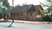
This building pinpoints the preliminary centre for law and order within the township of Boddington. Specifically, law courts, jail cells, and a police administration centre, was the entirety of the building. The building indicates Boddington's unforeseen growth as a result of the mining industry.
White weatherboards line the side of the building, windows are supported in metal window casings, and a dark plum corrugated roof encases the structure. The building is relatively small, with a playground outdoor area extending from the South-West of the building.
Constant lobbying to the Marradong Road Board instigated the construction of the Police Station. It is now used as a playgroup for children. Boddington's minig expansion and essentially the town associated population growth, made the building insufficient in size. Now Police are situated on the corner of Johnstone and Pollard Street in Boddington.
High
Good/Fair (rust affecting iron roof)
| Ref ID No | Ref Name | Ref Source | Ref Date |
|---|---|---|---|
| Municipal Heritage Inventory | 2000 | ||
| J Ferrell;"Becoming Boddington". | |||
| Western Australian Heritage Council |
| Reserve | Lot/Location | Plan/Diagram | Vol/Folio |
|---|---|---|---|
| 82 |
This information is provided voluntarily as a public service. The information provided is made available in good faith and is derived from sources believed to be reliable and accurate. However, the information is provided solely on the basis that readers will be responsible for making their own assessment of the matters discussed herein and are advised to verify all relevant representations, statements and information.
Wuraming Av Boddington
Boddington
Peel
| Type | Status | Date | Documents |
|---|---|---|---|
| (no listings) |
| Type | Status | Date | Documents |
|---|---|---|---|
| (no listings) |
| Type | Status | Date | Grading/Management | |
|---|---|---|---|---|
| Category | ||||
| Municipal Inventory | Adopted | 05 Apr 2011 | 3 | |
| Municipal Inventory | Adopted | 01 Jun 2011 | C | |
Other Built Type
| Epoch | General | Specific |
|---|---|---|
| Present Use | GOVERNMENTAL | Reservoir or Dam |
| Original Use | GOVERNMENTAL | Reservoir or Dam |
| General | Specific |
|---|---|
| OUTSIDE INFLUENCES | Water, power, major t'port routes |
This information is provided voluntarily as a public service. The information provided is made available in good faith and is derived from sources believed to be reliable and accurate. However, the information is provided solely on the basis that readers will be responsible for making their own assessment of the matters discussed herein and are advised to verify all relevant representations, statements and information.
Constructed from 1981
This is one of the largest Lions club projects. Many residents utilise this area as a place for bathing, catching fish, canoeing, and admiring, as an aesthetic pleasure. Most predominantly, The Weir acts as a welcoming area for visitors arriving from the Banister Road entrance of town.
The land surrounding The Lion's Weir has been cleared of jarrah and wandoo trees so the public can sit on the river bed. A dam has been constructed, and a concrete path secures the top of the falls. This path can be utilised in the summer months as the water levels significantly drop. Recent renovations have installed a gazebo and sitting areas. Additional vegetation has been established on the river shore.
In 1975, Shire Clerk Des Cunningham and Harold Cunningham actively sourced the Lions club. The earliest meeting was held in the year of 1976. Together they successfully organised and constructed some important infrastructure in the Shire of Boddington. One of the biggest projects was undertaken on the edge of Hotham River. Damming, enhancing, and clearing, was assisted by Bunnings workers, Waroona contracting services, and the Shire of Boddington. The place was intended as a scenic attraction and became a much harder job than initially thought. Alfred Gillespie and Marlon Reid obtained a cable digger from the Bauxite Mine which was considered a major asset for the completion of the task. Stabilizing the wall was the most difficult process to complete, which took 10 years. Now the large mass of water showcases Boddington as motorists come into town over the bridge. The river is used for Chinese boat racing during the Australia Day and Rodeo festivities, as well as marriages and parties.
Medium
Good
| Ref ID No | Ref Name | Ref Source | Ref Date |
|---|---|---|---|
| J Ferrell;"Becoming Boddington". |
This information is provided voluntarily as a public service. The information provided is made available in good faith and is derived from sources believed to be reliable and accurate. However, the information is provided solely on the basis that readers will be responsible for making their own assessment of the matters discussed herein and are advised to verify all relevant representations, statements and information.
Cnr Wuraming Av & Bannister Rd Boddington
Boddington District School,
Boddington Junior School
Boddington
Peel
Constructed from 1920 to 2005
| Type | Status | Date | Documents |
|---|---|---|---|
| Heritage List | Adopted | 16 Dec 2016 |
| Type | Status | Date | Documents |
|---|---|---|---|
| RHP - Assessed - Below Threshold | Current | 12 Mar 2003 | |
| RHP - To be assessed | Current | 23 Mar 2007 |
| Type | Status | Date | Grading/Management | |
|---|---|---|---|---|
| Category | ||||
| Municipal Inventory | Adopted | 18 Jul 2001 | 1 | |
| Municipal Inventory | Adopted | 01 Jun 2011 | A | |
| Classified by the National Trust | Classified | 10 Apr 2000 | ||
17812 Boddington Public Buildings Group
Generally in good contition. Reroofed with short sheets since 2006. Mostly repainted externally and internally with some refitting out.
| Name | Type | Year From | Year To |
|---|---|---|---|
| Public Works Deptartment (PWD), 1920 school | Architect | - | - |
| Howard, Bonner, Atkison and Shand, 1973 addtions | Architect | - | - |
| Library Id | Title | Medium | Year Of Publication |
|---|---|---|---|
| 8338 | Boddington old school. Conservation plan. | Heritage Study {Cons'n Plan} | 2006 |
| 3203 | Boddington District High : heritage assessment. | Heritage Study {Other} | 1998 |
| 6589 | Boddington old school complex : business plan. | Heritage Study {Other} | 2002 |
Individual Building or Group
| Epoch | General | Specific |
|---|---|---|
| Other Use | EDUCATIONAL | Secondary School |
| Present Use | SOCIAL\RECREATIONAL | Other |
| Original Use | EDUCATIONAL | Primary School |
| Present Use | EDUCATIONAL | Technical School |
| Other Use | EDUCATIONAL | Pre-primary Centre |
| Type | General | Specific |
|---|---|---|
| Roof | METAL | Corrugated Iron |
| Wall | TIMBER | Weatherboard |
| Other | TIMBER | Other Timber |
| Wall | BRICK | Common Brick |
| General | Specific |
|---|---|
| SOCIAL & CIVIC ACTIVITIES | Education & science |
This information is provided voluntarily as a public service. The information provided is made available in good faith and is derived from sources believed to be reliable and accurate. However, the information is provided solely on the basis that readers will be responsible for making their own assessment of the matters discussed herein and are advised to verify all relevant representations, statements and information.
Constructed from 1920, Constructed from 2005
The school configuration represents the historical growth pattern of the town. The long and prosperous progress of the Boddington Township can be illustrated by the ongoing formation of detached structures on the site. Gardens and traditional architectural formations represent Boddington's nature.
The Old School consists of two major detached buildings, surrounding rooms and a toilet block. The original building was dedicated to the primary school and the newer division was utilised for secondary students. The original school house, the building closest to Bannister Road, has a medium-pitch timber roof covered with painted corrugated iron. The building is framed with timber, externally clad with weatherboards and flat fibro-cement linings above. The primary school house functions as a double storey at the west end of the structure. Enclosed within the U-shape structure, lays a bitumen quadrangle. The secondary school is an L-shaped single storey building, with brick constitution, enclosed with a zincalum gable roof. A toilet block (1974), girls and boys shelter sheds (1948), manual arts room (1969), resource centre (1982), shed, and covered stage pavilion (2005), rest detached; lining the initial structures. The teachers quarters (1928), pre-school (1980), and a toilet block (1942) have been demolished in the transition of use.
Before the Boddington District High School was built, school groups would consist of merely twenty or so students. One teacher and one single room would facilitate these students. Numerous schools existed in the Marradong area, one in Crossman, one in Marlin, one at Quindanning, and one in Boddington. The number of schools can be explained by the lack of motorised transport, larger families/ increased population in rural areas and the significant distances␣␣␣␣␣␣␣␣␣␣␣␣␣␣␣, in was public policy to provide school buses for children. This was when Boddington School was used for all the children of the district. Once mining operations expanded, and the student population rose three-fold, local mining companies contributed $600,000 for additions to the existing buildings. A modern and practical school was designed and constructed elsewhere in town. The new school has sufficient space for future development.
High
Good
| Ref ID No | Ref Name | Ref Source | Ref Date |
|---|---|---|---|
| Western Australian Heritage Council | |||
| J Ferrell;"Becoming Boddington". | |||
| Municipal Heritage Inventory | 2000 | ||
| Elizabeth Hoeck | Boddington Development Group |
| Reserve | Lot/Location | Plan/Diagram | Vol/Folio |
|---|---|---|---|
| 17428 | 61/94/155&161 |
This information is provided voluntarily as a public service. The information provided is made available in good faith and is derived from sources believed to be reliable and accurate. However, the information is provided solely on the basis that readers will be responsible for making their own assessment of the matters discussed herein and are advised to verify all relevant representations, statements and information.
Boddington to Dwellingup
Precinct includes sidings & stations at: Dwellingup, Holyoake, Etmilyn, Plarins, Inglehope, Amphion, Chadora, Pindalup, Wuraming, Hotham, Tullis & Farmers Crossing (see MHI for more details)
Boddington
Peel
Constructed from 1894 to 1968
| Type | Status | Date | Documents |
|---|---|---|---|
| Heritage List | Adopted | 16 Dec 2014 |
| Type | Status | Date | Documents |
|---|---|---|---|
| RHP - Does not warrant assessment | Current | 28 Jun 2019 |
| Type | Status | Date | Grading/Management | |
|---|---|---|---|---|
| Category | ||||
| Municipal Inventory | Adopted | 18 Jul 2001 | 3 | |
| Municipal Inventory | Adopted | 01 Jun 2011 | C | |
MHI states condition is 'Fair-Poor'.
Landscape
| Epoch | General | Specific |
|---|---|---|
| Present Use | VACANT\UNUSED | Vacant\Unused |
| Original Use | Transport\Communications | Rail: Other |
| Type | General | Specific |
|---|---|---|
| Other | METAL | Steel |
| Other | TIMBER | Other Timber |
| General | Specific |
|---|---|
| DEMOGRAPHIC SETTLEMENT & MOBILITY | Settlements |
| TRANSPORT & COMMUNICATIONS | Rail & light rail transport |
| DEMOGRAPHIC SETTLEMENT & MOBILITY | Resource exploitation & depletion |
| OCCUPATIONS | Timber industry |
| PEOPLE | Early settlers |
This information is provided voluntarily as a public service. The information provided is made available in good faith and is derived from sources believed to be reliable and accurate. However, the information is provided solely on the basis that readers will be responsible for making their own assessment of the matters discussed herein and are advised to verify all relevant representations, statements and information.
Constructed from 1894
The construction of the railway through Boddington prompted Boddington as the focal point for development, instead of Marradong and Hotham River.
The railway extends throughout Boddington, particularly in the Hotham River precinct. It is an extension from the Dwellingup and Pinjarra line. The remnants of the line are in relatively good condition. The railway sleepers and steel line still exist intact. However, a large chunk has been removed for the Boddington Industrial area. Most of the railway line is now overgrown with trees and shrubbery.
The construction of the railway line was integral for the timber industry in Boddington. The railway ceased operations in 1968.
Medium
Fair-Poor
| Ref ID No | Ref Name | Ref Source | Ref Date |
|---|---|---|---|
| Western Australian Heritage Council | |||
| J Ferrell;"Becoming Boddington". | |||
| Municipal Heritage Inventory | 2000 |
This information is provided voluntarily as a public service. The information provided is made available in good faith and is derived from sources believed to be reliable and accurate. However, the information is provided solely on the basis that readers will be responsible for making their own assessment of the matters discussed herein and are advised to verify all relevant representations, statements and information.
Albany Hwy over Collie River Crossman
Old Albany Hwy alignment at 131.66 SLK over Patten Gully
Bridge No 0019
Boddington
Peel
Constructed from 1928
| Type | Status | Date | Documents |
|---|---|---|---|
| Heritage List | Adopted | 16 Dec 2014 |
| Type | Status | Date | Documents |
|---|---|---|---|
| (no listings) |
| Type | Status | Date | Grading/Management | |
|---|---|---|---|---|
| Category | ||||
| Municipal Inventory | Adopted | 01 Jun 2011 | C | |
| Municipal Inventory | Adopted | 18 Jul 2001 | 3 | |
Historic site
| Epoch | General | Specific |
|---|---|---|
| Present Use | Transport\Communications | Road: Bridge |
| Original Use | Transport\Communications | Road: Bridge |
This information is provided voluntarily as a public service. The information provided is made available in good faith and is derived from sources believed to be reliable and accurate. However, the information is provided solely on the basis that readers will be responsible for making their own assessment of the matters discussed herein and are advised to verify all relevant representations, statements and information.
Constructed from 1928
The Crossman River Bridge signifies the original settlement pattern of Boddington and the industries that had influenced the town's growth. The Crossman River Bridge demonstrates the changing of constructing methods, materials and technology.
The Crossman Road Bridge extends approximately 100 metres, over the Crossman River. The simple design has been significantly modified to ensure future durability. Original jarrah panelling has been reinforced with metal frames. Similarly, jarrah pylons have been armoured by concrete blocks and additional metal trimmings.
The Crossman Road Bridge is a significantly used construction located on the Albany Highway. Local residents generally used this bridge to travel to Perth and other locations. Crossman has been an agricultural district dating back to the 1800's when JH Morgan resided in the district. A school was constructed in the Crossman district, but later closed in the 1960's, when the Boddington School became more preferable. The bridge has continually served to aid the Boddington community of Crossman.
Medium
Good
| Ref ID No | Ref Name | Ref Source | Ref Date |
|---|---|---|---|
| J Ferrell;"Becoming Boddington". | |||
| Municipal Heritage Inventory | 2000 | ||
| Western Australian Heritage Council |
This information is provided voluntarily as a public service. The information provided is made available in good faith and is derived from sources believed to be reliable and accurate. However, the information is provided solely on the basis that readers will be responsible for making their own assessment of the matters discussed herein and are advised to verify all relevant representations, statements and information.
Pinjarra-Williams Rd Hotham River
m.53 at SLK M 61.70, Map 1, VG4 HERITAGE ASSESSMENT RECOMMENDED FOR OLD BRIDGE ONLY
MRWA 407 current bridge
Boddington
Peel
Constructed from 1992, Constructed from 1964
| Type | Status | Date | Documents |
|---|---|---|---|
| Heritage List | Adopted | 16 Dec 2014 |
| Type | Status | Date | Documents |
|---|---|---|---|
| RHP - Does not warrant assessment | Current | 12 Dec 2003 |
| Type | Status | Date | Grading/Management | |
|---|---|---|---|---|
| Category | ||||
| Municipal Inventory | Adopted | 01 Jun 2011 | D | |
| Municipal Inventory | Adopted | 11 Dec 1998 | 4 | |
| Statewide Lge Timber Str Survey | Completed | 11 Dec 1998 | ||
Other Built Type
| Epoch | General | Specific |
|---|---|---|
| Original Use | Transport\Communications | Road: Bridge |
| Present Use | Transport\Communications | Road: Bridge |
| General | Specific |
|---|---|
| TRANSPORT & COMMUNICATIONS | Road transport |
This information is provided voluntarily as a public service. The information provided is made available in good faith and is derived from sources believed to be reliable and accurate. However, the information is provided solely on the basis that readers will be responsible for making their own assessment of the matters discussed herein and are advised to verify all relevant representations, statements and information.
Constructed from 1964
The Camballing road bridge signifies the changing technology and industries surrounding the Boddington/ Marradong area. The area now requires stronger, greater supporting bridges for mining activity.
The Camballling Road Bridge is supported by large jarrah rounds. Sleepers are lined across the top of the bridge where soil now lays along with shrub. The Camballing road bridge collapses in the middle of the structure in the river. Decay seems to be the reason for the collapse.
The Camballing Road Bridge served the early community of Marradong. It was a prime fishing and recreational spot for local residents.
Medium
Poor
| Ref ID No | Ref Name | Ref Source | Ref Date |
|---|---|---|---|
| Western Australian Heritage Council | |||
| Municipal Heritage Inventory | 2000 | ||
| J Ferrell;"Becoming Boddington". |
This information is provided voluntarily as a public service. The information provided is made available in good faith and is derived from sources believed to be reliable and accurate. However, the information is provided solely on the basis that readers will be responsible for making their own assessment of the matters discussed herein and are advised to verify all relevant representations, statements and information.
East of Pinjarra-Williams Rd Marradong
Located about 50m north of site of Marradong Hall
Boddington
Peel
Constructed from 1891
| Type | Status | Date | Documents |
|---|---|---|---|
| (no listings) |
| Type | Status | Date | Documents |
|---|---|---|---|
| (no listings) |
| Type | Status | Date | Grading/Management | |
|---|---|---|---|---|
| Category | ||||
| Municipal Inventory | Adopted | 18 Jul 2001 | T | |
| Municipal Inventory | Adopted | 01 Jun 2011 | E | |
Historic Site
| Epoch | General | Specific |
|---|---|---|
| Original Use | GOVERNMENTAL | Other |
| General | Specific |
|---|---|
| SOCIAL & CIVIC ACTIVITIES | Government & politics |
| DEMOGRAPHIC SETTLEMENT & MOBILITY | Settlements |
This information is provided voluntarily as a public service. The information provided is made available in good faith and is derived from sources believed to be reliable and accurate. However, the information is provided solely on the basis that readers will be responsible for making their own assessment of the matters discussed herein and are advised to verify all relevant representations, statements and information.
Constructed from 1891
This site marks the initial stages of political and governmental organisation within the Marradong and Boddington districts.
Originally, the site was marked by a large sawn-off tree stump, where the men gathered around. Nowadays, the stump has been removed and the site remains bare.
In October 1891, at the east side of Pinjarra-Williams Road, the Marradong Roads Board decided to be officially developed. The men met around a stump of a tree, using it as a table top. Before this point of time, the Boddington and Marradong district were under the direction of the Williams Road Board.
Low
Poor
| Ref ID No | Ref Name | Ref Source | Ref Date |
|---|---|---|---|
| J Ferrell;"Becoming Boddington". | |||
| Municipal Heritage Inventory | 2000 | ||
| Western Australian Heritage Council |
| Reserve | Lot/Location | Plan/Diagram | Vol/Folio |
|---|---|---|---|
| 6743 |
This information is provided voluntarily as a public service. The information provided is made available in good faith and is derived from sources believed to be reliable and accurate. However, the information is provided solely on the basis that readers will be responsible for making their own assessment of the matters discussed herein and are advised to verify all relevant representations, statements and information.
Johnstone Street Marradong
Boddington
Peel
Constructed from 1920 to 2005
| Type | Status | Date | Documents |
|---|---|---|---|
| (no listings) |
| Type | Status | Date | Documents |
|---|---|---|---|
| RHP - To be assessed | Current | 23 Mar 2007 |
| Type | Status | Date | Grading/Management | |
|---|---|---|---|---|
| Category | ||||
| (no listings) | ||||
Individual Building or Group
| Epoch | General | Specific |
|---|---|---|
| Original Use | EDUCATIONAL | Combined School |
| Present Use | GOVERNMENTAL | Town, Shire or District Hall |
| Original Use | GOVERNMENTAL | Town, Shire or District Hall |
| Original Use | GOVERNMENTAL | Office or Administration Bldg |
| Present Use | SOCIAL\RECREATIONAL | Other Community Hall\Centre |
| Present Use | EDUCATIONAL | Technical School |
| Style |
|---|
| Federation Academic Classical |
| Federation Bungalow |
| Type | General | Specific |
|---|---|---|
| Wall | ASBESTOS | Fibrous Cement, flat |
| Wall | ASBESTOS | Other Asbestos |
| Wall | BRICK | Common Brick |
| Wall | TIMBER | Weatherboard |
| Roof | METAL | Corrugated Iron |
| Wall | METAL | Zincalume |
| General | Specific |
|---|---|
| DEMOGRAPHIC SETTLEMENT & MOBILITY | Settlements |
| TRANSPORT & COMMUNICATIONS | Rail & light rail transport |
| SOCIAL & CIVIC ACTIVITIES | Education & science |
| SOCIAL & CIVIC ACTIVITIES | Community services & utilities |
| SOCIAL & CIVIC ACTIVITIES | Government & politics |
This information is provided voluntarily as a public service. The information provided is made available in good faith and is derived from sources believed to be reliable and accurate. However, the information is provided solely on the basis that readers will be responsible for making their own assessment of the matters discussed herein and are advised to verify all relevant representations, statements and information.
Pinjarra-Williams Rd Marradong
Marradong hotel
Boddington
Peel
Constructed from 1901
| Type | Status | Date | Documents |
|---|---|---|---|
| (no listings) |
| Type | Status | Date | Documents |
|---|---|---|---|
| (no listings) |
| Type | Status | Date | Grading/Management | |
|---|---|---|---|---|
| Category | ||||
| Municipal Inventory | Adopted | 18 Jul 2001 | T | |
| Municipal Inventory | Adopted | 01 Jun 2011 | E | |
Historic Site
| Epoch | General | Specific |
|---|---|---|
| Original Use | COMMERCIAL | Hotel, Tavern or Inn |
| Type | General | Specific |
|---|---|---|
| Wall | BRICK | Other Brick |
| Roof | METAL | Corrugated Iron |
| General | Specific |
|---|---|
| DEMOGRAPHIC SETTLEMENT & MOBILITY | Settlements |
| PEOPLE | Early settlers |
| OCCUPATIONS | Hospitality industry & tourism |
This information is provided voluntarily as a public service. The information provided is made available in good faith and is derived from sources believed to be reliable and accurate. However, the information is provided solely on the basis that readers will be responsible for making their own assessment of the matters discussed herein and are advised to verify all relevant representations, statements and information.
Constructed from 1947, Constructed from 1902
The Laura Hotel was one of the first buildings, and accommodation facility, constructed in the Marradong area. It was an important location for social activity, especially among local timber workers. Local workers also frequently stayed at the hotel. The hotel teamed as a shop and post office, which made it an important meeting place in the district.
This development was the third of all brick structures built in the Marradong area. It had corrugated iron roofing. The site is now signified by distinctly large palm trees on both sides of the Pinjarra-Williams Road.
The Laura Hotel was built by Eliza Farmer, widow of Thomas Farmer. She operated the Hotel until transferring to the Quindanning Hotel. In this time, the Hotel became a popular spot for timber workers in the area and an accommodation post for teachers. Mr Fagan later bought the building and leased it to John Vagg until 1911. The Reidys then leased the Hotel, until Fagan sold in 1916 to W. Hawkins. Mr Hawkins transferred the licence over to the Boddington Hotel. After the license was transferred, The Laura Hotel was again sold to John and Jessie Vagg, who utilised the facility for a Post Office, Store, Commonwealth Bank, and Bed and Breakfast. George Batt later bought the place, where he lived with his family and operated the post office facility before demolishing the building in 1947.
Low
Poor
| Ref ID No | Ref Name | Ref Source | Ref Date |
|---|---|---|---|
| J Ferrell;"Becoming Boddington". | |||
| Municipal Heritage Inventory | 2000 | ||
| Western Australian Heritage Council |
This information is provided voluntarily as a public service. The information provided is made available in good faith and is derived from sources believed to be reliable and accurate. However, the information is provided solely on the basis that readers will be responsible for making their own assessment of the matters discussed herein and are advised to verify all relevant representations, statements and information.
Pinjarra-Williams Rd Marradong
Reserve No. 2943 Vol 710 Folio 95 according to MHI 2000
Boddington
Peel
Constructed from 1901
| Type | Status | Date | Documents |
|---|---|---|---|
| (no listings) |
| Type | Status | Date | Documents |
|---|---|---|---|
| (no listings) |
| Type | Status | Date | Grading/Management | |
|---|---|---|---|---|
| Category | ||||
| Municipal Inventory | Adopted | 01 Jun 2011 | E | |
| Municipal Inventory | Adopted | 15 Nov 1995 | T | |
Historic Site
| Epoch | General | Specific |
|---|---|---|
| Original Use | SOCIAL\RECREATIONAL | Other Community Hall\Centre |
| Present Use | VACANT\UNUSED | Vacant\Unused |
| Type | General | Specific |
|---|---|---|
| Wall | BRICK | Other Brick |
| Roof | METAL | Corrugated Iron |
| General | Specific |
|---|---|
| SOCIAL & CIVIC ACTIVITIES | Sport, recreation & entertainment |
This information is provided voluntarily as a public service. The information provided is made available in good faith and is derived from sources believed to be reliable and accurate. However, the information is provided solely on the basis that readers will be responsible for making their own assessment of the matters discussed herein and are advised to verify all relevant representations, statements and information.
Constructed from 1901
This was the second major public building built in the Marradong area. It was an important social and administrative venue for the developing township of Boddington and Marradong.
Initially about 40ft by 20 ft made from local bricks and corrugated iron. According to the original 1896 plans, weatherboard was originally proposed. Completed in 1901, the building was constructed of triple bricked walls and corrugated iron roofing. Nowadays, the Marradong Volunteer fire brigade inhabits the site space.
The Hall was originally used as a Marradong Roads Board Meeting House and an office for the Road Board Secretary between 1902 and 1925. The public utilised the facility for New Years Eve celebrations, dances, concerts, receptions, political meetings, farmer's meetings, roller-skating, and lunch gatherings following church meetings (Ferrell, 1992). After 1982, when electricity became available, the Shire of Boddington took over the facility. It was later demolished in 1989 as alternative venues were available and the cost of repairing the facility was steep. The site is now used for the Marradong Volunteer Fire Service.
Low
Poor
| Ref ID No | Ref Name | Ref Source | Ref Date |
|---|---|---|---|
| J Ferrell;"Becoming Boddington". | |||
| Municipal Heritage Inventory | 2000 | ||
| Western Australian Heritage Council |
| Reserve | Lot/Location | Plan/Diagram | Vol/Folio |
|---|---|---|---|
| 8203 |
This information is provided voluntarily as a public service. The information provided is made available in good faith and is derived from sources believed to be reliable and accurate. However, the information is provided solely on the basis that readers will be responsible for making their own assessment of the matters discussed herein and are advised to verify all relevant representations, statements and information.
Pinjarra-Williams Rd Marradong
Site only, marked by wattle trees on the west side of Pinjarra-Williams Rd (50-100 south of Marradong Brook) Cnr Pinjarra-Williams & Red Hill Rd
Boddington
Peel
| Type | Status | Date | Documents |
|---|---|---|---|
| (no listings) |
| Type | Status | Date | Documents |
|---|---|---|---|
| (no listings) |
| Type | Status | Date | Grading/Management | |
|---|---|---|---|---|
| Category | ||||
| Municipal Inventory | Adopted | 01 Jun 2011 | E | |
| Municipal Inventory | Adopted | 18 Jul 2001 | T | |
Historic Site
| Epoch | General | Specific |
|---|---|---|
| Original Use | EDUCATIONAL | Primary School |
| Present Use | VACANT\UNUSED | Vacant\Unused |
| General | Specific |
|---|---|
| SOCIAL & CIVIC ACTIVITIES | Education & science |
| DEMOGRAPHIC SETTLEMENT & MOBILITY | Settlements |
This information is provided voluntarily as a public service. The information provided is made available in good faith and is derived from sources believed to be reliable and accurate. However, the information is provided solely on the basis that readers will be responsible for making their own assessment of the matters discussed herein and are advised to verify all relevant representations, statements and information.
The Marradong School Site marks one of the first school sites in the area of Marradong. It signifies the area of initial settlement and the growth of the number of residents.
A gathering of wattle trees mark the former site.
The Marradong School was a small building, erected high off the ground, and was entered via a wooden ramp. Families who attended the school in 1934-35 were the Fletchers, Freebres (Ron, Mary, Jean), Gwen and Bernie Bowens, Tony Barker , Vern Nichols and the Batts. The school later closed as residents were sent to Boddington District High School.
Low
Poor
| Ref ID No | Ref Name | Ref Source | Ref Date |
|---|---|---|---|
| Western Australian Heritage Council | |||
| Municipal Heritage Inventory | 2000 | ||
| J Ferrell;"Becoming Boddington". |
This information is provided voluntarily as a public service. The information provided is made available in good faith and is derived from sources believed to be reliable and accurate. However, the information is provided solely on the basis that readers will be responsible for making their own assessment of the matters discussed herein and are advised to verify all relevant representations, statements and information.
Pinjarra-Williams Rd Marradong
Boddington
Peel
| Type | Status | Date | Documents |
|---|---|---|---|
| (no listings) |
| Type | Status | Date | Documents |
|---|---|---|---|
| (no listings) |
| Type | Status | Date | Grading/Management | |
|---|---|---|---|---|
| Category | ||||
| Municipal Inventory | Adopted | 05 Apr 2011 | T | |
| Municipal Inventory | Adopted | 01 Jun 2011 | E | |
Historic Site
| Epoch | General | Specific |
|---|---|---|
| Original Use | COMMERCIAL | Shop\Retail Store {single} |
| Type | General | Specific |
|---|---|---|
| Wall | STONE | Other Stone |
| General | Specific |
|---|---|
| OCCUPATIONS | Commercial & service industries |
This information is provided voluntarily as a public service. The information provided is made available in good faith and is derived from sources believed to be reliable and accurate. However, the information is provided solely on the basis that readers will be responsible for making their own assessment of the matters discussed herein and are advised to verify all relevant representations, statements and information.
Monday's store was one of the first stores in the Marradong area. It signified one of the first settling families who contributed to the original Marradong economy.
What remains of the store is the remnants of a stone chimney and fig trees, which would have once bordered the small store.
Monday's Store was the main general and grocery store in the Marradong area. It is believed to be one of the first buildings in the Marradong district.
Low
| Ref ID No | Ref Name | Ref Source | Ref Date |
|---|---|---|---|
| G Fawcett | |||
| J & A Batt |
This information is provided voluntarily as a public service. The information provided is made available in good faith and is derived from sources believed to be reliable and accurate. However, the information is provided solely on the basis that readers will be responsible for making their own assessment of the matters discussed herein and are advised to verify all relevant representations, statements and information.
6743 Pinjarra-Williams Rd Marradong
Springfield
Tom Pollards's Homestead (fmr)
Boddington
Peel
| Type | Status | Date | Documents |
|---|---|---|---|
| Heritage List | Adopted | 16 Dec 2014 |
| Type | Status | Date | Documents |
|---|---|---|---|
| (no listings) |
| Type | Status | Date | Grading/Management | |
|---|---|---|---|---|
| Category | ||||
| Municipal Inventory | Adopted | 05 Apr 2011 | 3 | |
| Municipal Inventory | Adopted | 01 Jun 2011 | C | |
MHI states condition as 'Poor'.
Individual Building or Group
| Epoch | General | Specific |
|---|---|---|
| Present Use | FARMING\PASTORAL | Homestead |
| Original Use | FARMING\PASTORAL | Homestead |
| Type | General | Specific |
|---|---|---|
| Roof | METAL | Corrugated Iron |
| Wall | EARTH | Adobe {Mud Brick} |
| Other | ASBESTOS | Other Asbestos |
| General | Specific |
|---|---|
| DEMOGRAPHIC SETTLEMENT & MOBILITY | Settlements |
| OCCUPATIONS | Grazing, pastoralism & dairying |
This information is provided voluntarily as a public service. The information provided is made available in good faith and is derived from sources believed to be reliable and accurate. However, the information is provided solely on the basis that readers will be responsible for making their own assessment of the matters discussed herein and are advised to verify all relevant representations, statements and information.
Constructed from 1900
This cottage is one of a few buildings of this design, and of material formation remaining in the area. This was built by one of the first settlers in the Boddington locality.
Small mud brick cottage with iron roofing.
This homestead is understood to be utilised by some of the first residents of the Marradong area. The husband was a shepherd in the area for the Wilkie's. His wife had fourteen children living inside the home.
High
Fair/Poor
| Ref ID No | Ref Name | Ref Source | Ref Date |
|---|---|---|---|
| Municipal Heritage Inventory | 2000 | ||
| J & A Batt | |||
| J Ferrell;"Becoming Boddington". | |||
| Western Australian Heritage Council |
This information is provided voluntarily as a public service. The information provided is made available in good faith and is derived from sources believed to be reliable and accurate. However, the information is provided solely on the basis that readers will be responsible for making their own assessment of the matters discussed herein and are advised to verify all relevant representations, statements and information.
Lot 11899 Pinjarra-Williams Rd Marradong
Boddington
Peel
| Type | Status | Date | Documents |
|---|---|---|---|
| (no listings) |
| Type | Status | Date | Documents |
|---|---|---|---|
| (no listings) |
| Type | Status | Date | Grading/Management | |
|---|---|---|---|---|
| Category | ||||
| Municipal Inventory | Adopted | 01 Jun 2011 | E | |
| Municipal Inventory | Adopted | 05 Apr 2011 | T | |
Historic Site
| Epoch | General | Specific |
|---|---|---|
| Original Use | EDUCATIONAL | Primary School |
This information is provided voluntarily as a public service. The information provided is made available in good faith and is derived from sources believed to be reliable and accurate. However, the information is provided solely on the basis that readers will be responsible for making their own assessment of the matters discussed herein and are advised to verify all relevant representations, statements and information.
Camballing Marradong School site represents the former area of residents, and marks one of the first schools in the area of Marradong.
Originally stood a single roomed wooden or mud brick building in the area of Marradong. A reserve remains on the school site.
School groups in the Marradong area consisted of approximately twenty students and one teacher. Many schools were formed as space was abundant between residents. Originally, three schools in Marradong used the word "Marradong" in their school's name. Consequently, it is hard to decipher between schools, school sites, and school houses. Amalgamation occurred in the 1940's when it became policy to provide a school bus service for the Marradong students. Boddington School was ultimately the education facility for the district of Marradong. It is believed that school houses were eventually sold off.
Low
Poor
| Ref ID No | Ref Name | Ref Source | Ref Date |
|---|---|---|---|
| G Batt | |||
| J Ferrell;"Becoming Boddington". |
| Reserve | Lot/Location | Plan/Diagram | Vol/Folio |
|---|---|---|---|
| 14322 | 11899 |
This information is provided voluntarily as a public service. The information provided is made available in good faith and is derived from sources believed to be reliable and accurate. However, the information is provided solely on the basis that readers will be responsible for making their own assessment of the matters discussed herein and are advised to verify all relevant representations, statements and information.
Williams Rd Marradong
MHI states location is on Pinjarra-Williams Rd
Mokine Homestead
Boddington
Peel
Constructed from 1865
| Type | Status | Date | Documents |
|---|---|---|---|
| Heritage List | Adopted | 16 Dec 2014 |
| Type | Status | Date | Documents |
|---|---|---|---|
| RHP - To be assessed | Current | 23 Mar 2007 |
| Type | Status | Date | Grading/Management | |
|---|---|---|---|---|
| Category | ||||
| Municipal Inventory | Adopted | 01 Jun 2011 | B | |
| Municipal Inventory | Adopted | 15 Nov 1995 | 2 | |
· The place is highly significant for its association with the Fawcett Family, a prominent local pioneering family, who have lived and worked on the land for over 150 years.
· The place has some rarity as an example of a homestead that has been in the continued use of the same family since its settlement in the 1850s.
· The place is significant for its potential to reflect the connection between the Boddington area and the rest of the Peel Region, as demonstrated by the driving of sheep from the Fawcett’s Pinjarra property, ‘The Park” (P1760), to ‘Mokine’. (The MI notes that the current Pinjarra –Williams Road follows the route originally created by the driving of stock from “The Park” to “Mokine”.)
· The place is rare as the only known example of the use of stone in building in the early homesteads of the Boddington/Marradong district.
· The place may have additional rarity value for its association with Aboriginal Shepherds and for its connections to the horse trade between early West Australian pioneering families and the Indian Army.
· The place has associations with the flour milling industry in the area, and is interesting for the early alterations to turn the original mill into part of the homestead.
A large homestead constructed of local stone and brick with a corrugated iron roof (originally sheoak shingles). The original flour mill section (northern end) is built of local stone and (on site) pit-sawn jarrah timber. The front of the building has a large bull-nosed veranda and has been cement rendered. A brick addition comprises the southern end of the homestead, with the further addition of an asbestos clad bathroom and kitchen.
‘Mokine Homestead was built c1865 by Captain Fawcett, on land he had taken up in the 1850s, as an outpost where he kept sheep and horses. His son, Theodore John Henry Fawcett, accompanied shipments of horses to Ceylon. Supplying then as remounts for the Indian Army. Captain Fawcett and Tom Pollard rode their horses, following the Murray River from Pinjarra to the junction of the Hotham and Williams River, in search of Winter pasture. Here they continued taking the Hotham River branch, then possibly followed the Marradong Valley or Brook until they came to Mokine. It was the abundance of water that enticed them to set up an outpost there. The original (aboriginal) name was Mokeup- the “up” referring to water.'
2001 MHI entry states in the place is in a 'Fair' condition
Individual Building or Group
| Epoch | General | Specific |
|---|---|---|
| Original Use | FARMING\PASTORAL | Homestead |
| Present Use | FARMING\PASTORAL | Homestead |
| Type | General | Specific |
|---|---|---|
| Wall | STONE | Local Stone |
| Roof | METAL | Corrugated Iron |
| Other | TIMBER | Other Timber |
| Wall | ASBESTOS | Other Asbestos |
| Wall | BRICK | Common Brick |
| General | Specific |
|---|---|
| OCCUPATIONS | Grazing, pastoralism & dairying |
| DEMOGRAPHIC SETTLEMENT & MOBILITY | Settlements |
This information is provided voluntarily as a public service. The information provided is made available in good faith and is derived from sources believed to be reliable and accurate. However, the information is provided solely on the basis that readers will be responsible for making their own assessment of the matters discussed herein and are advised to verify all relevant representations, statements and information.
Constructed from 1865
Mokine Homestead is associated with original settlers in the Marradong area. Captain Fawcett was an important member of the community, in terms of establishing governmental and political organisation. The homestead is made of stone, which is considered a rare construction material, especially in the current time. The home also provides proof of prior flour milling.
Mokine Homestead is a residence constructed of local stone and brick with a corrugated iron roof. The front of the home has been lightened in cement rendering and the front of the building is bordered with a bull-nose veranda.
The area surrounding Mokine Homestead was claimed to be a good source of red clay for aboriginal groups in the mid 1800's. They used the clay for body paint and cultural ceremonies. This area is said to be a site of many aboriginal burials. The name "Mokin" originated from the aboriginal word 'Mokeup' which refers to the abundance of water at the site. Captain Fawcett worked with aboriginal groups as he said that they tended to be ideal shepherds. He eventually, after spending most of his time in the Pinjarra region, settled in Mokine. In 1865, it was understood that he constructed this homestead from part of a mill. Additions were made at about the same time of Captain Fawcett's death. Afterwards, it became the home for his son, father of Charles and Allen. Family members still reside at the homestead. Captain Fawcett was the first Chairperson on the Murray Road Board. His son, T. J. H. Fawcett, was the first chairperson of the Marradong Road Board.
Medium/High
Good
| Ref ID No | Ref Name | Ref Source | Ref Date |
|---|---|---|---|
| J Ferrell;"Becoming Boddington". | |||
| Municipal Heritage Inventory | 2000 | ||
| Western Australian Heritage Council |
| Reserve | Lot/Location | Plan/Diagram | Vol/Folio |
|---|---|---|---|
| 82 |
This information is provided voluntarily as a public service. The information provided is made available in good faith and is derived from sources believed to be reliable and accurate. However, the information is provided solely on the basis that readers will be responsible for making their own assessment of the matters discussed herein and are advised to verify all relevant representations, statements and information.
Williams Rd Marradong
MHI states this place is located on the Pinjarra-Williams Road
Boddington
Peel
Constructed from 1882
| Type | Status | Date | Documents |
|---|---|---|---|
| Heritage List | Adopted | 16 Dec 2014 |
| Type | Status | Date | Documents |
|---|---|---|---|
| (no listings) |
| Type | Status | Date | Grading/Management | |
|---|---|---|---|---|
| Category | ||||
| Municipal Inventory | Adopted | 15 Nov 1995 | 2 | |
| Municipal Inventory | Adopted | 01 Jun 2011 | B | |
MHI (2001) states the condition of the place is 'Fair'.
Individual Building or Group
| Epoch | General | Specific |
|---|---|---|
| Other Use | Transport\Communications | Comms: Post or Telegraph Office |
| Original Use | FARMING\PASTORAL | Homestead |
| Present Use | FARMING\PASTORAL | Homestead |
| Type | General | Specific |
|---|---|---|
| Roof | METAL | Corrugated Iron |
| Wall | BRICK | Handmade Brick |
| General | Specific |
|---|---|
| OCCUPATIONS | Grazing, pastoralism & dairying |
This information is provided voluntarily as a public service. The information provided is made available in good faith and is derived from sources believed to be reliable and accurate. However, the information is provided solely on the basis that readers will be responsible for making their own assessment of the matters discussed herein and are advised to verify all relevant representations, statements and information.
Constructed from 1882
Red Hill Homestead signifies organisational, political, farming, and scientific activity within the Marradong region. The homestead is one of the first to be constructed in the area, and one of the only remaining in use.
Red Hill Homestead is a small red brick homestead,traditional, colonial, dual chimney homestead surrounded by corrugated iron sheds. It is located in the Red Hill gully and is surrounded by farming activity.
The homestead was an important building for Marradong residents for many years. It was once the local post office (1883), weather recording station (1889) and a telegraph station (1895). It is likely that the Marradong Road Board utilised the space for meetings before a more appropriate venue was built in Boddington. This Red Hill Homestead is one of the few remaining homesteads that is still used as a home and for farming operations in the area.
High
Good
| Ref ID No | Ref Name | Ref Source | Ref Date |
|---|---|---|---|
| Western Australian Heritage Council | |||
| Municipal Heritage Inventory | 2000 | ||
| J Ferrell;"Becoming Boddington". |
| Reserve | Lot/Location | Plan/Diagram | Vol/Folio |
|---|---|---|---|
| 87 |
This information is provided voluntarily as a public service. The information provided is made available in good faith and is derived from sources believed to be reliable and accurate. However, the information is provided solely on the basis that readers will be responsible for making their own assessment of the matters discussed herein and are advised to verify all relevant representations, statements and information.
"Clover Glen", Farmer's Av Mokine/Boddington
Located 94 mile, 60 chain stop from Pinjarra Also part of P17635 Railway Line Precinct-Boddington to Dwellingup.
Brockman's Crossing, Brockman
Farmers' Railway Siding and Goods Shed
Boddington
Peel
| Type | Status | Date | Documents |
|---|---|---|---|
| (no listings) |
| Type | Status | Date | Documents |
|---|---|---|---|
| RHP - To be assessed | Current | 23 Mar 2007 |
| Type | Status | Date | Grading/Management | |
|---|---|---|---|---|
| Category | ||||
| Municipal Inventory | YES | 01 Jun 2011 | E | |
| Municipal Inventory | Adopted | 15 Nov 1995 | T | |
17811 Hotham River Homestead Group
MHI states condition 'Poor-Fair'
| Name | Type | Year From | Year To |
|---|---|---|---|
| MLA Mr E. E. Johnstone | Architect | - | - |
Individual Building or Group
| Epoch | General | Specific |
|---|---|---|
| Original Use | Transport\Communications | Rail: Other |
| Type | General | Specific |
|---|---|---|
| Other | TIMBER | Other Timber |
| Roof | METAL | Corrugated Iron |
| Wall | METAL | Corrugated Iron |
| General | Specific |
|---|---|
| PEOPLE | Famous & infamous people |
| DEMOGRAPHIC SETTLEMENT & MOBILITY | Settlements |
| TRANSPORT & COMMUNICATIONS | Rail & light rail transport |
This information is provided voluntarily as a public service. The information provided is made available in good faith and is derived from sources believed to be reliable and accurate. However, the information is provided solely on the basis that readers will be responsible for making their own assessment of the matters discussed herein and are advised to verify all relevant representations, statements and information.
Constructed from 1920
17811 Hotham River Homestead Group
Farmer's Crossing was a significant siding for the people of Marradong as it was a location used for the delivery of goods and services for the district.
After a storm blew away the corrugated iron goods shed, making the siding, only building materials remain on the site.
Farmer's Crossing was a railwy station constructed on the Farmer's property. The plan for the railway to be located on the Farmer's land was, initially, much to their dismay. The Western Australian Railway offered the railway siding was established as a means of compensation to the family. The name "Farmer's Crossing" wasa much objected to and the Brockman Family won their case to call the siding "Brockman" instead. However, this did not last, as Mr E Johnson contested on behalf of the Farmer family. Three years later, in 1923, Farmer's Crossing resumed back to its original name.
Low
Poor
| Ref ID No | Ref Name | Ref Source | Ref Date |
|---|---|---|---|
| Western Australian Heritage Council | |||
| J Ferrell;"Becoming Boddington". | |||
| C. R. Farmer | |||
| Municipal Heritage Inventory | 2000 |
| Reserve | Lot/Location | Plan/Diagram | Vol/Folio |
|---|---|---|---|
| 8795 |
This information is provided voluntarily as a public service. The information provided is made available in good faith and is derived from sources believed to be reliable and accurate. However, the information is provided solely on the basis that readers will be responsible for making their own assessment of the matters discussed herein and are advised to verify all relevant representations, statements and information.
Long Gully Rd Quindanning
Main Road Bridge No. 4559
Banksiadale Sawmill tramway, Timber Company
Tramway Bridge, MRWA 4559, Long Gully Bridge
Boddington
Peel
Constructed from 1992, Constructed from 1949
| Type | Status | Date | Documents |
|---|---|---|---|
| Heritage List | Adopted | 16 Dec 2014 | |
| State Register | Registered | 08 Dec 2006 | HCWebsite.Listing+ListingDocument, HCWebsite.Listing+ListingDocument |
| Type | Status | Date | Documents |
|---|---|---|---|
| (no listings) |
| Type | Status | Date | Grading/Management | |
|---|---|---|---|---|
| Category | ||||
| Municipal Inventory | Adopted | 01 Sep 1995 | 1 | |
| Municipal Inventory | Adopted | 01 Jun 2011 | A | |
| Statewide Lge Timber Str Survey | Completed | 11 Dec 1998 | ||
Destroyed by fire in February 2015
| Library Id | Title | Medium | Year Of Publication |
|---|---|---|---|
| 7386 | Images CD No. 38 : assessment images: Serpentine Store; Asquith Bridge. | C D Rom | 2005 |
Other Built Type
| Epoch | General | Specific |
|---|---|---|
| Present Use | SOCIAL\RECREATIONAL | Other |
| Other Use | Transport\Communications | Road: Bridge |
| Original Use | Transport\Communications | Rail: Other |
| Style |
|---|
| Other Style |
| Type | General | Specific |
|---|---|---|
| Other | TIMBER | Other Timber |
| General | Specific |
|---|---|
| SOCIAL & CIVIC ACTIVITIES | Sport, recreation & entertainment |
| TRANSPORT & COMMUNICATIONS | Road transport |
| TRANSPORT & COMMUNICATIONS | Rail & light rail transport |
| OCCUPATIONS | Timber industry |
This information is provided voluntarily as a public service. The information provided is made available in good faith and is derived from sources believed to be reliable and accurate. However, the information is provided solely on the basis that readers will be responsible for making their own assessment of the matters discussed herein and are advised to verify all relevant representations, statements and information.
Constructed from 1949, Constructed from 1952
Considered an outstanding example of an early rail trestle bridge. It epitomises the technical design skill of the Western Australian Government Railways. It is believed by the Heritage Council to be one of the finest railway bridges in the State. The construction is associated with the Post World War II development of Western Australian Railways. It also promotes great aesthetic opportunities.
The Bridge meets sections of land that rise steeply above Murray River valleys. The construct runs in a north-south direction, 10 metres high, approximately 3 metres wide, and 128 metres long.
The bridge was built for the WA Government Railways. It was later transferrred over to the then Deptartment of Conservation and Land Management. The rail network was used as an integral mode for the timber industry from the Serpentine-Jarrahdale area to Dwellingup region. When the Dwellingup Mill was burned down in 1961, the track ceased operation. The bridge was later converted to road usage until the 1990's. In 1997, the Asquith Bridge became a feature of the Bibbulmun Track.
High
Good (some termite damage)
| Ref ID No | Ref Name | Ref Source | Ref Date |
|---|---|---|---|
| Western Australian Heritage Council | |||
| Municipal Heritage Inventory | 2000 | ||
| J Ferrell;"Becoming Boddington". |
This information is provided voluntarily as a public service. The information provided is made available in good faith and is derived from sources believed to be reliable and accurate. However, the information is provided solely on the basis that readers will be responsible for making their own assessment of the matters discussed herein and are advised to verify all relevant representations, statements and information.
Marradong-Quindanning Rd Quindanning
Quindanning falls in both the Shire of Williams and the Shire of Boddington. This place is identified in the MHI of both Shires. Child places are only in the Williams MI.
Boddington
Peel
| Type | Status | Date | Documents |
|---|---|---|---|
| (no listings) |
| Type | Status | Date | Documents |
|---|---|---|---|
| (no listings) |
| Type | Status | Date | Grading/Management | |
|---|---|---|---|---|
| Category | ||||
| Municipal Inventory | Adopted | 01 Jun 2011 | C | |
| Municipal Inventory | Adopted | 30 Jun 2000 | 3 | |
Fair
Individual Building or Group
| Epoch | General | Specific |
|---|---|---|
| Original Use | FARMING\PASTORAL | Shed or Barn |
| Original Use | RESIDENTIAL | Single storey residence |
| Present Use | FARMING\PASTORAL | Shed or Barn |
| Type | General | Specific |
|---|---|---|
| Wall | BRICK | Common Brick |
| Wall | TIMBER | Log |
| Roof | METAL | Corrugated Iron |
| General | Specific |
|---|---|
| OCCUPATIONS | Grazing, pastoralism & dairying |
| DEMOGRAPHIC SETTLEMENT & MOBILITY | Settlements |
This information is provided voluntarily as a public service. The information provided is made available in good faith and is derived from sources believed to be reliable and accurate. However, the information is provided solely on the basis that readers will be responsible for making their own assessment of the matters discussed herein and are advised to verify all relevant representations, statements and information.
Represents a development period, in terms of the growth in grazing, pastoral, and dairying.
The house site and shearing shed once rested on the bank of the Warrening Gully, on the East of the Pinjarra Williams Road. The shearing shed that remains is significantly depreciating.
The Rowell's house site and shearing shed are one of the first agricultural operations in the Marradong area. The house no longer remains, although the shearing shed still stands. When the current owners bought the homestead in 1975, the house was cleared and the shearing shed was the only building remaining of the original homestead.
Medium
Poor
| Ref ID No | Ref Name | Ref Source | Ref Date |
|---|---|---|---|
| Western Australian Heritage Council |
This information is provided voluntarily as a public service. The information provided is made available in good faith and is derived from sources believed to be reliable and accurate. However, the information is provided solely on the basis that readers will be responsible for making their own assessment of the matters discussed herein and are advised to verify all relevant representations, statements and information.
lot 42 Cowcher Rd Ranford
Boddington
Peel
| Type | Status | Date | Documents |
|---|---|---|---|
| (no listings) |
| Type | Status | Date | Documents |
|---|---|---|---|
| (no listings) |
| Type | Status | Date | Grading/Management | |
|---|---|---|---|---|
| Category | ||||
| Municipal Inventory | Adopted | 01 Jun 2011 | D | |
| Municipal Inventory | Adopted | 18 Jul 2001 | 4 | |
MHI notes the condition as 'Poor',
Individual Building or Group
| Epoch | General | Specific |
|---|---|---|
| Present Use | UNKNOWN | UNKNOWN |
| Original Use | RESIDENTIAL | Single storey residence |
| Type | General | Specific |
|---|---|---|
| Wall | TIMBER | Weatherboard |
| Roof | METAL | Corrugated Iron |
This information is provided voluntarily as a public service. The information provided is made available in good faith and is derived from sources believed to be reliable and accurate. However, the information is provided solely on the basis that readers will be responsible for making their own assessment of the matters discussed herein and are advised to verify all relevant representations, statements and information.
This building is typical example of the type of residence constructed during the time of the Tannin Factory. However, new modifications do not replicate initial historic value.
Tomato Tony's is an old, small, timber made, corrugated iron roofed residence. New modifications clash with the original building.
The cottage was one of the first built in the Ranford area. It responded to the growth of the Tannin Extracts Factory. 'Tomato Tony' was an early resident, selling his vegetables to Ranford and Boddington residents. The cottage was later used to house post-war migrants. The area surrounding the house was utilised by aboriginal communities during and after the war. They mainly lived in tents and rough buildings.
Low
Fair
| Ref ID No | Ref Name | Ref Source | Ref Date |
|---|---|---|---|
| J Ferrell;"Becoming Boddington". | |||
| Western Australian Heritage Council | |||
| Municipal Heritage Inventory | 2000 |
| Reserve | Lot/Location | Plan/Diagram | Vol/Folio |
|---|---|---|---|
| 42 |
This information is provided voluntarily as a public service. The information provided is made available in good faith and is derived from sources believed to be reliable and accurate. However, the information is provided solely on the basis that readers will be responsible for making their own assessment of the matters discussed herein and are advised to verify all relevant representations, statements and information.