Local Government
Broome
Region
Kimberley
Anne St Cnr Robinson St Broome
Broome
Kimberley
| Type | Status | Date | Documents |
|---|---|---|---|
| (no listings) |
| Type | Status | Date | Documents |
|---|---|---|---|
| (no listings) |
| Type | Status | Date | Grading/Management | |
|---|---|---|---|---|
| Category | ||||
| Register of the National Estate | Removed from RNE | |||
| Classified by the National Trust | Classified | 07 Jun 1983 | ||
Former owner reported building removed to new location. (1988)
| Library Id | Title | Medium | Year Of Publication |
|---|---|---|---|
| 8335 | Historic buildings of the Kimberley region of W.A. | Book | 1988 |
| 9600 | Broome: maps and places of heritage interest. | Heritage Study {Other} | 0 |
Individual Building or Group
| Epoch | General | Specific |
|---|---|---|
| Present Use | COMMERCIAL | Shopping Complex |
| Original Use | COMMERCIAL | Shopping Complex |
| General | Specific |
|---|---|
| OCCUPATIONS | Commercial & service industries |
This information is provided voluntarily as a public service. The information provided is made available in good faith and is derived from sources believed to be reliable and accurate. However, the information is provided solely on the basis that readers will be responsible for making their own assessment of the matters discussed herein and are advised to verify all relevant representations, statements and information.
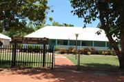
Typical example of the "Pearl Masters" house and its structural form in largely original condition.
Single storied, timber framed structure, corrugated iron cladding on walls nd roof, latticed verandah. It is sheltered from the road by a well developed stand of trees. The surrounding garden is typical of Broome's ornamental vegetation.
This information is provided voluntarily as a public service. The information provided is made available in good faith and is derived from sources believed to be reliable and accurate. However, the information is provided solely on the basis that readers will be responsible for making their own assessment of the matters discussed herein and are advised to verify all relevant representations, statements and information.
11 Barker St Broome
was 14
Centacare
Broome
Kimberley
Constructed from 1926
| Type | Status | Date | Documents |
|---|---|---|---|
| Heritage List | Adopted | 28 Aug 2014 | |
| State Register | Registered | 26 Aug 2008 | HCWebsite.Listing+ListingDocument, HCWebsite.Listing+ListingDocument |
| Type | Status | Date | Documents |
|---|---|---|---|
| (no listings) |
| Type | Status | Date | Grading/Management | |
|---|---|---|---|---|
| Category | ||||
| Municipal Inventory | Adopted | 28 Aug 2014 | Grading A | |
| Name | Type | Year From | Year To |
|---|---|---|---|
| Hori Gorokitchi | Architect | - | - |
| Goro Kichihoro | Architect | - | - |
| Library Id | Title | Medium | Year Of Publication |
|---|---|---|---|
| 10017 | St John of God Convent (fmr), Broome | Heritage Study {Cons'n Plan} | 2012 |
| 9462 | A pearler's wife: chapter extraction from 'A pearling master's journey'. | Book | 2009 |
Individual Building or Group
| Epoch | General | Specific |
|---|---|---|
| Original Use | RELIGIOUS | Monastery or Convent |
| Present Use | SOCIAL\RECREATIONAL | Other |
| Style |
|---|
| North-West Vernacular |
| Type | General | Specific |
|---|---|---|
| Roof | METAL | Corrugated Iron |
| Wall | TIMBER | Other Timber |
| General | Specific |
|---|---|
| OTHER | Other Sub-Theme |
| SOCIAL & CIVIC ACTIVITIES | Education & science |
| SOCIAL & CIVIC ACTIVITIES | Religion |
| DEMOGRAPHIC SETTLEMENT & MOBILITY | Racial contact & interaction |
| PEOPLE | Aboriginal people |
| SOCIAL & CIVIC ACTIVITIES | Community services & utilities |
This information is provided voluntarily as a public service. The information provided is made available in good faith and is derived from sources believed to be reliable and accurate. However, the information is provided solely on the basis that readers will be responsible for making their own assessment of the matters discussed herein and are advised to verify all relevant representations, statements and information.
Constructed from 1926
St John of God Convent is significant for the associations with the St John of God sisters, and the continuous use as a community care facility.
The single storey timber framed building with perimeter verandah is located central within a flat-grassed setting. The roof is hipped and the main roof covers the verandahs.
The Sisters of St John of God arrived in Broome in 1908. Their first home was a tin hut where they lived by day, sleeping in the church at night. The Chinese and Japanese shopkeepers gave them bedding and crockery. The Sisters nursed in the Japanese and District hospitals. A verandah, two bedrooms, kitchen and storeroom were added to the hut in 1909. A Catholic school was built in 1911, at which they taught. In 1926, the convent was built for them by Japanese carpenter Hori Gorokitchi. Gorokitchi arrived in Western Australia in May 1891, at the age of twenty-three. He worked as a builder and contractor in Broome, employing Japanese carpenters and constructing many buildings, including the former McDaniel Residence (Ref 45). The Sisters of St John of God occupied the Convent until 1967. Two Sisters spent over 60 years at Broome. Sisters Alphonse and Ignatius celebrated their Diamond Jubilee in Broome in 1975, and for their work in the North, Sister Alphonse was awarded the OBE and Sister Ignatius the MBE. The building has served a number of community needs, and was occupied by the Binagarra Counselling Service in 1996.
High degree High degree
Good
| Ref ID No | Ref Name | Ref Source | Ref Date |
|---|---|---|---|
| Register documentation | |||
| L Gray & I Sauman | Conservation Plan | 2012 |
| Ref Number | Description |
|---|---|
| No.5 | MI Place No. |
| Reserve | Lot/Location | Plan/Diagram | Vol/Folio |
|---|---|---|---|
| 301 |
This information is provided voluntarily as a public service. The information provided is made available in good faith and is derived from sources believed to be reliable and accurate. However, the information is provided solely on the basis that readers will be responsible for making their own assessment of the matters discussed herein and are advised to verify all relevant representations, statements and information.
17 Barker St Broome
Office of Local Member of Parliament
Resindenc (former)
Broome
Kimberley
Constructed from 1910
| Type | Status | Date | Documents |
|---|---|---|---|
| (no listings) |
| Type | Status | Date | Documents |
|---|---|---|---|
| (no listings) |
| Type | Status | Date | Grading/Management | |
|---|---|---|---|---|
| Category | ||||
| Municipal Inventory | Adopted | 28 Aug 2014 | Grading C | |
Individual Building or Group
| Epoch | General | Specific |
|---|---|---|
| Original Use | HEALTH | Other |
| Present Use | GOVERNMENTAL | Office or Administration Bldg |
| Style |
|---|
| Federation Bungalow |
| General | Specific |
|---|---|
| SOCIAL & CIVIC ACTIVITIES | Community services & utilities |
This information is provided voluntarily as a public service. The information provided is made available in good faith and is derived from sources believed to be reliable and accurate. However, the information is provided solely on the basis that readers will be responsible for making their own assessment of the matters discussed herein and are advised to verify all relevant representations, statements and information.
Constructed from 1910
Residence (former) is typical of its period, and a remaining example that is representative of development over time.
The single storey timber framed structure has horizontal corrugated iron wall cladding. The hipped roof clad with colorbond features a central front gablet. The shutters are fibrocement above a lattice dado.
Lot 120 is divided into two lots. H. D. Forbes, solicitor, and Les Dobson of Dobson's General Store were the owners and occupants of the houses on Lot 120.
High degree Moderate degree
Good
| Ref ID No | Ref Name | Ref Source | Ref Date |
|---|---|---|---|
| Tom Chapple, Broome | The Exciting Years | 1912-1930 |
| Ref Number | Description |
|---|---|
| No.6 | MI Place No. |
| Reserve | Lot/Location | Plan/Diagram | Vol/Folio |
|---|---|---|---|
| 214 |
This information is provided voluntarily as a public service. The information provided is made available in good faith and is derived from sources believed to be reliable and accurate. However, the information is provided solely on the basis that readers will be responsible for making their own assessment of the matters discussed herein and are advised to verify all relevant representations, statements and information.
Boundary of the Broome Common or former Municipal Boundary Chinatown Broome
Boundary of the Broome Common, or former Municipal Boundary Chinatown to the airstrip and to the meatworks.
Town Gate
Broome
Kimberley
| Type | Status | Date | Documents |
|---|---|---|---|
| Heritage List | Adopted | 27 Jun 2019 |
| Type | Status | Date | Documents |
|---|---|---|---|
| (no listings) |
| Type | Status | Date | Grading/Management | |
|---|---|---|---|---|
| Category | ||||
| Municipal Inventory | Adopted | 27 Jun 2019 | Grading B | |
Historic site
| General | Specific |
|---|---|
| DEMOGRAPHIC SETTLEMENT & MOBILITY | Workers {incl. Aboriginal, convict} |
| SOCIAL & CIVIC ACTIVITIES | Law & order |
| PEOPLE | Aboriginal people |
| DEMOGRAPHIC SETTLEMENT & MOBILITY | Government policy |
| DEMOGRAPHIC SETTLEMENT & MOBILITY | Racial contact & interaction |
| TRANSPORT & COMMUNICATIONS | Road transport |
| DEMOGRAPHIC SETTLEMENT & MOBILITY | Aboriginal Occupation |
This information is provided voluntarily as a public service. The information provided is made available in good faith and is derived from sources believed to be reliable and accurate. However, the information is provided solely on the basis that readers will be responsible for making their own assessment of the matters discussed herein and are advised to verify all relevant representations, statements and information.
• Common Gate has historic value for its association with the period during the 20th century when the movement of Aboriginal people was strictly controlled. • The remnant elements of the Common Gate are rare physical reminders of past practices. • The place has social value for the Aboriginal people who have memories of the practices of control and division typified by the Common Gate. For those with no direct experience the stories have been passed down to younger generations. • The remnant elements of the fence and gate have historic value for their association with the Aborigines Act 1905 which had such a profound effect on the lives of the Aboriginal people of the region. • The areas adjacent to the former Common Gate have potential research value as they may contain archaeological deposits.
There are a series of remnant posts remaining between Paspaley Shopping Centre and the Broome Road. The timber posts which remain from the former fence line are in poor condition.
The Common Gate is the name used to refer to the wire fence and gates that marked the municipal boundary of the township of Broome. The fence line was initially erected to keep cattle out of the town but, following the passing of Western Australia's Aborigines Act 1905, the fence around the town was used as a physical boundary to regulate the movement of Aboriginal people. Aboriginal people who lived outside the townsite could enter Broome if they could demonstrate they had 'lawful employment'. If not they could be forcibly removed from the 'prohibited area'. The 'common gate' had a significant effect on Aboriginal people and the Broome community. Originally there were three gates across roads into Broome. The main gate was at the entrance on the Old Broome Road near the junction with Bagot and Short Streets. The second gate was at the junction of present day Barker and Herbert Streets and the third gate at the corner of Dora and Guy Streets. These entry points were locked with a large gate at 6 pm each night by police. This form of control of Aboriginal people was enforced until 1954 when the section of the Native Welfare Act repealed many of the sections of the Native Administration Act. For many decades the fence remained in situ although its condition gradually deteriorated. Large portions of the fence were removed by local men Jimmy Edgar and Jimmy Tany Wei who used a grader for the task while they were working for the State Electricity Commission. In 2007, an exhibition titled ‘Opening the Common Gate’ was put together by the Lingiari foundation and the Yawuru people to highlight how the policy of segregation operated what affect that had on individuals and the community. The use of the Common Gate as a readily identifiable symbol of segregation demonstrates how well known and significant the fence and gate were to all members of the community but particularly Aboriginal people.
This information is provided voluntarily as a public service. The information provided is made available in good faith and is derived from sources believed to be reliable and accurate. However, the information is provided solely on the basis that readers will be responsible for making their own assessment of the matters discussed herein and are advised to verify all relevant representations, statements and information.
bounded by Anne, Robinson, Barker and Walcott Sts Broome
This place does not include P5368 Community Health Services
Broome
Kimberley
Constructed from 1950
| Type | Status | Date | Documents |
|---|---|---|---|
| (no listings) |
| Type | Status | Date | Documents |
|---|---|---|---|
| RHP - Does not warrant assessment | Current | 10 Dec 2004 |
| Type | Status | Date | Grading/Management | |
|---|---|---|---|---|
| Category | ||||
| (no listings) | ||||
| Library Id | Title | Medium | Year Of Publication |
|---|---|---|---|
| 9462 | A pearler's wife: chapter extraction from 'A pearling master's journey'. | Book | 2009 |
Individual Building or Group
| Epoch | General | Specific |
|---|---|---|
| Original Use | HEALTH | Hospital |
| Style |
|---|
| Vernacular |
| Type | General | Specific |
|---|---|---|
| Other | CONCRETE | Other Concrete |
| Other | TIMBER | Other Timber |
| Wall | ASBESTOS | Fibrous Cement, flat |
| Roof | METAL | Steel |
| Roof | METAL | Corrugated Iron |
| Wall | CONCRETE | Concrete Block |
| Other | GLASS | Glass |
| Wall | OTHER | Other Material |
| Roof | METAL | Other Metal |
| General | Specific |
|---|---|
| SOCIAL & CIVIC ACTIVITIES | Community services & utilities |
| DEMOGRAPHIC SETTLEMENT & MOBILITY | Settlements |
This information is provided voluntarily as a public service. The information provided is made available in good faith and is derived from sources believed to be reliable and accurate. However, the information is provided solely on the basis that readers will be responsible for making their own assessment of the matters discussed herein and are advised to verify all relevant representations, statements and information.
26 Broome - Cape Leveque Road Broome
Reserve 22615, 26 Broome - Cape Leveque Road
Smirnoff Beach, Carnot Bay
Broome
Kimberley
| Type | Status | Date | Documents |
|---|---|---|---|
| Heritage List | Adopted | 27 Jun 2019 |
| Type | Status | Date | Documents |
|---|---|---|---|
| (no listings) |
| Type | Status | Date | Grading/Management | |
|---|---|---|---|---|
| Category | ||||
| Municipal Inventory | Adopted | 27 Jun 2019 | Grading B | |
Historic site
| General | Specific |
|---|---|
| PEOPLE | Aboriginal people |
| PEOPLE | Local heroes & battlers |
| TRANSPORT & COMMUNICATIONS | Air transport |
| OUTSIDE INFLUENCES | World Wars & other wars |
| OUTSIDE INFLUENCES | Refugees |
| PEOPLE | Famous & infamous people |
This information is provided voluntarily as a public service. The information provided is made available in good faith and is derived from sources believed to be reliable and accurate. However, the information is provided solely on the basis that readers will be responsible for making their own assessment of the matters discussed herein and are advised to verify all relevant representations, statements and information.
• The site has historic value as the site of the crash of Dutch Douglas DC-3 brought down by an attack by Japanese Fighter Planes on 3 March 1942. • The site has historic value for its association with the bombing of Broome on 3 March 1942 by Japanese Fighter planes during World War II which was a significant event in the history of the town. • The site has historic value for its association with the evacuation of refugees from Indonesia and demonstrates the role northern Australia played during this period of the World War II. • The site has historic value for its association with individuals who played a role in the events at this site; Captain Smirnoff the pilot, the flight crew and the rescuers from Beagle Bay Community including Warrant Officer Class 2 Frederick Clinch, Brother Richard Bessenfelder and local man Joe Bernard. • The site has social value for community as the celebrated story of the crash, the rescue and the mystery of the lost diamonds contributes to the history and identity of the region.
In the early morning of 3 March 1942 nine Japanese Zero Fighter planes strafed 15 flying boats in Roebuck Bay, Broome, as well as several allied planes on the Broome air strip. 26 Planes were destroyed on the strip and in the bay. Over a hundred people died in the attack, which lasted no more than 20 minutes. Among the victims were more than 60 Dutch nationals, of which 50 civilians, who were being evacuated from Indonesia in anticipation of a Japanese attack. On their way back the Zero's encountered a Dutch Douglas DC-3 named the Pelikaan, piloted by Captain Ivan Smirnoff, on its way from Indonesia to Broome transporting Dutch refugees. Just prior to take off Smirnoff was handed a package to be handed to a Commonwealth Bank representative on arrival in Australia. It contained diamonds worth approximately $20 million although Smirnoff was unaware of its contents. The plane was shot down and crash-landed in Carnot Bay, approximately 80 km north of Broome. Four of the group died as they waited to be rescued, including an 18-month-old toddler, and were buried in the wet sand flats. During the four days that the group spent on the remote Kimberley beach, desperately searching for water and help, there was at least one unsuccessful attempt to retrieve the box from the damaged aircraft. After being attacked by a passing Japanese bomber that had picked up their position via a faint SOS call from the group's ramshackle radio, the group were rescued by a search party from Beagle Bay, 60 kilometres north. This search party was led by Warrant Officer Frederick Clinch, Brother Richard Bessenfelder and local man Joe Bernard. The survivors were first taken to Beagle Bay and then on to Broome two days later. It is believed that local fisherman and beachcomber Jack Palmer visited the wreckage shortly after the rescue to salvage anything valuable. He is understood to have found either some or all of the diamonds. After a period in which Palmer was seen around Broome displaying signs of wealth, he handed over a package of diamonds to the authorities. He was charged with theft but it was never proven that he had taken all the diamonds and subsequently acquitted. Palmer was taken back to the wreckage in April 1942 as part of the investigations into the story and during that visit parts of the aircraft was salvaged. Locals recall that diamonds were sighted in a number of locations in the following years and even after the war stories would emerge of the lost diamonds. The site in Carnot Bay has been subsequently named Smirnoff Bay after Captain Smirnoff whose skill in landing the damaged plane in such difficult conditions enabled the majority of the group to survive. The remains of the Dakota remained on the beach until 1970, when the stripped fuselage was broken up by dynamite. A memorial was erected at the site in 1942 by the Australian Army, and replaced in the 1990's. A third commemorative memorial was unveiled at Smirnoff Beach on 22 June 2013 to honour those who lost their lives, the survivors and the rescuers. At the ceremony were representatives of the Dutch Embassy and relatives of the crew and passengers.
| Reserve | Lot/Location | Plan/Diagram | Vol/Folio |
|---|---|---|---|
| 22615 |
This information is provided voluntarily as a public service. The information provided is made available in good faith and is derived from sources believed to be reliable and accurate. However, the information is provided solely on the basis that readers will be responsible for making their own assessment of the matters discussed herein and are advised to verify all relevant representations, statements and information.
8 Broome Rd Broome
Broome
Kimberley
Constructed from 1977
| Type | Status | Date | Documents |
|---|---|---|---|
| (no listings) |
| Type | Status | Date | Documents |
|---|---|---|---|
| (no listings) |
| Type | Status | Date | Grading/Management | |
|---|---|---|---|---|
| Category | ||||
| (no listings) | ||||
Historic site
| Epoch | General | Specific |
|---|---|---|
| Original Use | MONUMENT\CEMETERY | Monument |
| Present Use | MONUMENT\CEMETERY | Monument |
| General | Specific |
|---|---|
| PEOPLE | Famous & infamous people |
This information is provided voluntarily as a public service. The information provided is made available in good faith and is derived from sources believed to be reliable and accurate. However, the information is provided solely on the basis that readers will be responsible for making their own assessment of the matters discussed herein and are advised to verify all relevant representations, statements and information.
Constructed from 1977
| Reserve | Lot/Location | Plan/Diagram | Vol/Folio |
|---|---|---|---|
| 8176 | Lot 1317 |
This information is provided voluntarily as a public service. The information provided is made available in good faith and is derived from sources believed to be reliable and accurate. However, the information is provided solely on the basis that readers will be responsible for making their own assessment of the matters discussed herein and are advised to verify all relevant representations, statements and information.
Broome Sandstone Broome
Broome Sandstone
Dinosaur footprints
Broome
Kimberley
| Type | Status | Date | Documents |
|---|---|---|---|
| Heritage List | Adopted | 27 Jun 2019 |
| Type | Status | Date | Documents |
|---|---|---|---|
| (no listings) |
| Type | Status | Date | Grading/Management | |
|---|---|---|---|---|
| Category | ||||
| Municipal Inventory | Adopted | 27 Jun 2019 | Grading A | |
Historic site
| General | Specific |
|---|---|
| SOCIAL & CIVIC ACTIVITIES | Education & science |
| (none) | |
| SOCIAL & CIVIC ACTIVITIES | Environmental awareness |
This information is provided voluntarily as a public service. The information provided is made available in good faith and is derived from sources believed to be reliable and accurate. However, the information is provided solely on the basis that readers will be responsible for making their own assessment of the matters discussed herein and are advised to verify all relevant representations, statements and information.
The following statements are drawn from the Australian National Heritage entry for the place prepared in 2011 with additional information published by Salisbury et al (2017). The Dampier Coast dinosaur tracks have outstanding heritage value to the nation; • as the best and most extensive evidence of dinosaurs from the western half of the continent, some of which are unknown from body fossils; • The highest diversity of dinosaur tracks anywhere in the world (21 different types); • The only definitive evidence of stegosaurs in Australia; • The first described sauropod tracks in Australia; • Some of the largest dinosaur tracks in the world; • Only evidence of dinosaurs from this time period in Australia (approximately 130 million years ago); • The tracks are linked to the Dreamtime stories of the indigenous people along the Dampier Peninsula coastline, from Bunginygun (Swan Point, Cape Leveque) to Wabana (Cape Bossut, near Bidyadanga/La Grange) which have been retold over many generations.
The Broome Sandstone is exposed discontinuously for over at least 100 km of coastline from Gulbunwilla on Roebuck Bay east of Broome north to Minarriny (Coloumb Point), and possibly as far north as Cape Leveque. At most places where this rock formation has been uncovered, whether by gradual erosion or the pounding of cyclonic seas, dinosaur footprints have been found. At least 21 different types of footprints are recognised, making this the most diverse collections of dinosaurian trace fossils in the world. Over 70 discrete tracksites have been identified, many of which preserve short sections of trackways (sequences of prints recording the movement of one or more animals).
Geologists explain the formation of the Kimberley in terms of physical forces which have shaped present landforms over thousands of millions of years: the movement of continental plates; shifts in climate and sea level; and the action of wind, water and ice on rock. Geologists situate change in geological periods, which are defined with reference to global geological and evolutionary developments. The dinosaur footprints on the Dampier Peninsula are dated to the ‘Mesozoic era’, the age of the dinosaurs approximately 252 million years ago to 66 million years ago. The Mesozoic era is divided into three periods; the Triassic, Jurassic and Creatceous. From around 200 million years ago, in the early Jurassic period, the Kimberley Plateau once again formed part of a large island landmass, separated from the Northern Australian and Pilbara cratons by an inland sea. During the Cretaceous period, many species of dinosaurs occupied the area. As dinosaurs walked over swampy ground about 130 million years ago, they left tracks, some of which are preserved as fossils in the Broome Sandstone and exposed along the west coast of Dampier Peninsula. Fossilised remains of plants and pollens are found along with the tracks, which allow geologists to estimate their age. Plant remains and depositional features of the sandstone show the range of environments that these dinosaurs inhabited, which included rich lagoonal forests, estuaries, swamps and riverine areas. Knowledge of the dinosaur tracks by the local indigenous groups saw them included into their stories of the land and its creation, particularly those involving the Emu Man, Marala, who was the Law Giver. One of the first records of non-indigenous knowledge of the tracks was made by journalist and researcher, Daisy Bates is known to have sighted and recorded tracks near Broome while she was working at the Beagle Bay Mission around 1900. Other recordings in the 1930's and 1940's demonstrate that these remote tracks were known by the local residents, one of whom Walter ‘Snowy’ Jones, informed Ludiwg Glauert, Curator of the WA Museum. From the late 1940's, knowledge and understanding of the dinosaur tracks developed with the first accurate dating of the age of the tracks by Ludwig Glauert using the evidence of plant fossils collected by the Broome family, the Bardwells in the early 20th century. The tracks have provided inspiration for many artists, including Mary Durack and Russel Drysdale. In the 1950's, the tracks were an opportunity for education and research by naturalists Vincent Serventy and Harry Butler who took indigenous school children to the site. Research on the various sites continued through the second half of the 20th century by local and international scientists and in 2011, the tracks were included in the National Heritage List for the West Kimberley. The tracks continue to be a rich source of research and analysis for scientists, a link to creation stories for the indigenous people of the Dampier Peninsula and a place of interest for the local community.
This information is provided voluntarily as a public service. The information provided is made available in good faith and is derived from sources believed to be reliable and accurate. However, the information is provided solely on the basis that readers will be responsible for making their own assessment of the matters discussed herein and are advised to verify all relevant representations, statements and information.
Cable Beach Broome
Cable Keepers Cottage (fmr)
Broome
Kimberley
Constructed from 1889
| Type | Status | Date | Documents |
|---|---|---|---|
| Heritage List | Adopted | 28 Aug 2014 |
| Type | Status | Date | Documents |
|---|---|---|---|
| (no listings) |
| Type | Status | Date | Grading/Management | |
|---|---|---|---|---|
| Category | ||||
| Municipal Inventory | Adopted | 28 Aug 2014 | Grading B | |
Historic site
| Epoch | General | Specific |
|---|---|---|
| Original Use | Transport\Communications | Comms: Housing or Quarters |
| General | Specific |
|---|---|
| TRANSPORT & COMMUNICATIONS | Telecommunications |
This information is provided voluntarily as a public service. The information provided is made available in good faith and is derived from sources believed to be reliable and accurate. However, the information is provided solely on the basis that readers will be responsible for making their own assessment of the matters discussed herein and are advised to verify all relevant representations, statements and information.
Cable and building remains are a significant and relevant marker of the history of telecommunications and Broome’s pivotal role in that network.
The concrete foundations and housings of the cable and junction box are evident approximately half way along Cable Beach, in the sand dunes of Minyrr Park. The remains of the cable keepers cottage are also in the vicinity.
In 1888, the two undersea telegraph cables linking Java and Darwin were broken by volcanic activity and the Eastern Extension, Australasia and China Telegraph Company (E.E.T. Company), which operated the cable, decided to lay another cable from Java to the northwest coast. The cable was landed on the beach in February 1889 by the steamship Seine, at a place that has ever since been known as Cable Beach. A beach station was erected, completed by 3 March, and the cable was installed and tested. A section of cable was then run from the beach station across the peninsula to Broome Lot 99 where Cable House (Place no. 27)) had been erected for the staff of the E.E.T. Company. There the cable was linked to the overland telegraph line from Perth. The overland section of cable between Cable Beach and Cable House was placed inside a subterranean pipe. In 1901, the undersea cable to Broome became redundant when a new cable was laid from Durban to Adelaide. The cable to Broome carried little traffic for the next 13 years and was removed in March 1914. Broome remained linked to Perth and the rest of the world by the overland telegraph line. The beach station was still standing in the early 1920s when a police constable from Broome spent a week there to recuperate from fever.
Low degree High degree
Unknown
| Ref Number | Description |
|---|---|
| No.44 | MI Place No. |
This information is provided voluntarily as a public service. The information provided is made available in good faith and is derived from sources believed to be reliable and accurate. However, the information is provided solely on the basis that readers will be responsible for making their own assessment of the matters discussed herein and are advised to verify all relevant representations, statements and information.
Cable Beach Rd Broome
Shire of Bali Hai Caravan Resort
Broome
Kimberley
Constructed from 1985
| Type | Status | Date | Documents |
|---|---|---|---|
| (no listings) |
| Type | Status | Date | Documents |
|---|---|---|---|
| (no listings) |
| Type | Status | Date | Grading/Management | |
|---|---|---|---|---|
| Category | ||||
| Municipal Inventory | Adopted | 28 Aug 2014 | Grading C | |
| Name | Type | Year From | Year To |
|---|---|---|---|
| Oldham Boas Ednie-Brown | Architect | - | - |
Individual Building or Group
| Epoch | General | Specific |
|---|---|---|
| Original Use | COMMERCIAL | Hotel, Tavern or Inn |
| Present Use | COMMERCIAL | Hotel, Tavern or Inn |
| Type | General | Specific |
|---|---|---|
| Roof | METAL | Corrugated Iron |
| Wall | TIMBER | Other Timber |
| Wall | BRICK | Common Brick |
| General | Specific |
|---|---|
| OUTSIDE INFLUENCES | Tourism |
This information is provided voluntarily as a public service. The information provided is made available in good faith and is derived from sources believed to be reliable and accurate. However, the information is provided solely on the basis that readers will be responsible for making their own assessment of the matters discussed herein and are advised to verify all relevant representations, statements and information.
Constructed from 1986
Cable Beach Club represents the beginning of Broome as a tourist destination of an international standard. The Bali Hai Caravan Park had a long association with tourism on the site. Cable Beach Club is of significance for its distinctive architectural concept of the time, and as a place of memories and experiences associated with a holiday in Broome.
Cable Beach Resort is situated within a lush tropical setting overlooking Cable Beach. Cable Beach Club has motel and bungalow style accomodation.
Cable Beach Club was Robert Alistair (Lord) McAlpine major toursim project in Broome. Lord McAlpine had arrived by accident in Broome in the early 1980s on a redirected flight. He liked the town so much he became a major investor and developer, restoring buildings and constructing the resort. Cable Beach Club- originally named the International Cable Beach Resort, was built to provide accommodation to high international standards to complement the motel and caravan park accommodation already available in Broome. The bungalow style rooms were designed to reflect Broome's long multicultural history.
High degree High degree
Good
| Name | Type | Year From | Year To |
|---|---|---|---|
| Oldham Boas Ednie-Brown | Architect | - | - |
| Ref ID No | Ref Name | Ref Source | Ref Date |
|---|---|---|---|
| H. Edwards | A New Broome | 2008 |
| Ref Number | Description |
|---|---|
| No.45 | MI Place No. |
| Reserve | Lot/Location | Plan/Diagram | Vol/Folio |
|---|---|---|---|
| 1216,1217,1005 |
This information is provided voluntarily as a public service. The information provided is made available in good faith and is derived from sources believed to be reliable and accurate. However, the information is provided solely on the basis that readers will be responsible for making their own assessment of the matters discussed herein and are advised to verify all relevant representations, statements and information.
Carnarvon St Broome
REGISTERED AS PART OF 291
formerley part of T.B.Ellies stores
Broome
Kimberley
Constructed from 1922
| Type | Status | Date | Documents |
|---|---|---|---|
| (no listings) |
| Type | Status | Date | Documents |
|---|---|---|---|
| (no listings) |
| Type | Status | Date | Grading/Management | |
|---|---|---|---|---|
| Category | ||||
| (no listings) | ||||
00291 Chinatown Conservation Area
Individual Building or Group
| Epoch | General | Specific |
|---|---|---|
| Present Use | COMMERCIAL | Shop\Retail Store {single} |
| Original Use | COMMERCIAL | Shop\Retail Store {single} |
| General | Specific |
|---|---|
| OCCUPATIONS | Commercial & service industries |
This information is provided voluntarily as a public service. The information provided is made available in good faith and is derived from sources believed to be reliable and accurate. However, the information is provided solely on the basis that readers will be responsible for making their own assessment of the matters discussed herein and are advised to verify all relevant representations, statements and information.
10 Carnarvon St Broome
REGISTERED AS PART OF 291 Two Buildings on one lot also see P15881
Akim's Bakery (fmr)
Broome
Kimberley
Constructed from 1990
| Type | Status | Date | Documents |
|---|---|---|---|
| (no listings) |
| Type | Status | Date | Documents |
|---|---|---|---|
| (no listings) |
| Type | Status | Date | Grading/Management | |
|---|---|---|---|---|
| Category | ||||
| Municipal Inventory | Adopted | 23 Oct 2003 | Criterion 2 | |
00291 Chinatown Conservation Area
Individual Building or Group
| Epoch | General | Specific |
|---|---|---|
| Present Use | INDUSTRIAL\MANUFACTURING | Other |
| Original Use | INDUSTRIAL\MANUFACTURING | Bakery |
| General | Specific |
|---|---|
| OCCUPATIONS | Commercial & service industries |
This information is provided voluntarily as a public service. The information provided is made available in good faith and is derived from sources believed to be reliable and accurate. However, the information is provided solely on the basis that readers will be responsible for making their own assessment of the matters discussed herein and are advised to verify all relevant representations, statements and information.
Constructed from 1990
Lyons & Tate contributes to the character and townscape of Broome’s town centre.
The single storey timber framed building with front verandah is zero setback to the street frontage. The building and the gable roof are clad with corrugated iron. There is a double storey adjoining building at the rear of the office facility.
Lyons Tate office is a recent construction built as an investment property for Broome Chinese Community (Inc), owners of Shekki Shed on the same lot. In 1935-1940 the site was occupied by Akim’s bakery.
| Ref ID No | Ref Name | Ref Source | Ref Date |
|---|---|---|---|
| Heritage Council of WA Assessment documentation". | 2003 | ||
| S Yu & C Tang Wei;"The Story of the Chinese in Broome". |
This information is provided voluntarily as a public service. The information provided is made available in good faith and is derived from sources believed to be reliable and accurate. However, the information is provided solely on the basis that readers will be responsible for making their own assessment of the matters discussed herein and are advised to verify all relevant representations, statements and information.
10 Carnarvon St Broome
REGISTERED AS PART OF 291 Two Buildings on one lot also see P16878
Broome
Kimberley
Constructed from 1905
| Type | Status | Date | Documents |
|---|---|---|---|
| Heritage List | Adopted | 28 Aug 2014 |
| Type | Status | Date | Documents |
|---|---|---|---|
| (no listings) |
| Type | Status | Date | Grading/Management | |
|---|---|---|---|---|
| Category | ||||
| Municipal Inventory | Adopted | 28 Aug 2014 | Grading A | |
00291 Chinatown Conservation Area
| Library Id | Title | Medium | Year Of Publication |
|---|---|---|---|
| 8335 | Historic buildings of the Kimberley region of W.A. | Book | 1988 |
Individual Building or Group
| Epoch | General | Specific |
|---|---|---|
| Present Use | COMMERCIAL | Other |
| Original Use | RESIDENTIAL | Single storey residence |
| Original Use | COMMERCIAL | Other |
| Style |
|---|
| Vernacular |
| Type | General | Specific |
|---|---|---|
| Roof | METAL | Zincalume |
| Wall | METAL | Zincalume |
| General | Specific |
|---|---|
| OCCUPATIONS | Hospitality industry & tourism |
This information is provided voluntarily as a public service. The information provided is made available in good faith and is derived from sources believed to be reliable and accurate. However, the information is provided solely on the basis that readers will be responsible for making their own assessment of the matters discussed herein and are advised to verify all relevant representations, statements and information.
Constructed from 1905
00291 Chinatown Conservation Area
The single storey timber framed building with front verandah is zero setback to the street frontage. The timber framed building is clad with horizontal corrugated iron. The gabled corrugated iron roof continues over the front verandah and has the remnants of Chinese writing still visible.
The Shekki Shed Gallery comprises a shop and residence. In 1911, it was owned by a group of Chinese businessmen. Tenants at that time were Sam Sue and Ah Sue. In 1912, Ah Chi applied for an eating-house licence for the premises. In the 1930s it was the Chinese Tripe Store. The Shekki Shed is owned by the Broome Chinese Community (Inc)
This information is provided voluntarily as a public service. The information provided is made available in good faith and is derived from sources believed to be reliable and accurate. However, the information is provided solely on the basis that readers will be responsible for making their own assessment of the matters discussed herein and are advised to verify all relevant representations, statements and information.
12 Carnarvon St Broome
REGISTERED AS PART OF 291 Two Buildings on one lot also see P15880
Ghi Twan's Boarding House (fmr)
Broome
Kimberley
Constructed from 1930
| Type | Status | Date | Documents |
|---|---|---|---|
| Heritage List | Adopted | 28 Aug 2014 |
| Type | Status | Date | Documents |
|---|---|---|---|
| (no listings) |
| Type | Status | Date | Grading/Management | |
|---|---|---|---|---|
| Category | ||||
| Municipal Inventory | Adopted | 28 Aug 2014 | Grading A | |
00291 Chinatown Conservation Area
Individual Building or Group
| Epoch | General | Specific |
|---|---|---|
| Original Use | COMMERCIAL | Shop\Retail Store {single} |
| Present Use | COMMERCIAL | Restaurant |
| General | Specific |
|---|---|
| OCCUPATIONS | Commercial & service industries |
This information is provided voluntarily as a public service. The information provided is made available in good faith and is derived from sources believed to be reliable and accurate. However, the information is provided solely on the basis that readers will be responsible for making their own assessment of the matters discussed herein and are advised to verify all relevant representations, statements and information.
00291 Chinatown Conservation Area
The single storey timber framed building with front verandah is zero setback to the street frontage. The building and the gable roof are clad with colorbond cladding. The verandah roof is at break pitch.
In 1908, Ghi Twan ran a boarding house. In the 1930s tailor H. Choong also known as ‘Baldhead’ Tailor, occupied premises at the rear of the lot.
This information is provided voluntarily as a public service. The information provided is made available in good faith and is derived from sources believed to be reliable and accurate. However, the information is provided solely on the basis that readers will be responsible for making their own assessment of the matters discussed herein and are advised to verify all relevant representations, statements and information.
12 Carnarvon St Broome
REGISTERED AS PART OF 291 Two Buildings on one lot also see P16877
Terri's Travel
Broome
Kimberley
Constructed from 1908
| Type | Status | Date | Documents |
|---|---|---|---|
| Heritage List | Adopted | 28 Aug 2014 |
| Type | Status | Date | Documents |
|---|---|---|---|
| (no listings) |
| Type | Status | Date | Grading/Management | |
|---|---|---|---|---|
| Category | ||||
| Municipal Inventory | Adopted | 28 Aug 2014 | Grading A | |
00291 Chinatown Conservation Area
| Library Id | Title | Medium | Year Of Publication |
|---|---|---|---|
| 8335 | Historic buildings of the Kimberley region of W.A. | Book | 1988 |
Individual Building or Group
| Epoch | General | Specific |
|---|---|---|
| Original Use | RESIDENTIAL | Single storey residence |
| Original Use | RESIDENTIAL | Other |
| Original Use | COMMERCIAL | Office or Administration Bldg |
| Present Use | COMMERCIAL | Shop\Retail Store {single} |
| Original Use | COMMERCIAL | Shop\Retail Store {single} |
| Style |
|---|
| Vernacular |
| Type | General | Specific |
|---|---|---|
| Roof | METAL | Zincalume |
| Wall | METAL | Zincalume |
| General | Specific |
|---|---|
| OCCUPATIONS | Commercial & service industries |
This information is provided voluntarily as a public service. The information provided is made available in good faith and is derived from sources believed to be reliable and accurate. However, the information is provided solely on the basis that readers will be responsible for making their own assessment of the matters discussed herein and are advised to verify all relevant representations, statements and information.
Constructed from 1908
00291 Chinatown Conservation Area
Tack's Store (former) comprises a two-storey store and residence. The double storey timber framed building with front verandah is zero setback to the symmetrical street frontage. The building and the gable roof are clad with painted corrugated iron. The upstairs verandah balustrade is infilled with lattice.
Originally owned by pearler Hugh Norman, in 1908, it was leased to Ghi Twan who ran a boarding house on the premises. It was leased by storekeeper San Juan in 1913. Louey Ling Tack arrived in Broome in the 1910s. He operated as a pearl dealer from a store on corner of Dampier and Napier terraces from 1919 tuntil1926 when he returned to Hong Kong. By c.1920, he had purchased the building in Carnarvon Street and after his return to Hong Kong a family member, Arthur Fong Tack Louey, came to Broome to run the general merchant store. Arthur was treasurer and secretary of the Chinese Club for many years and Chinese interpreter for the Clerk of Courts when required. He continued to run the store until his death in 1988, aged 85, and is buried in the Chinese cemetery. Pearl Chong Fong-Louey, owns the place and has leased it to various businesses in recent years.
This information is provided voluntarily as a public service. The information provided is made available in good faith and is derived from sources believed to be reliable and accurate. However, the information is provided solely on the basis that readers will be responsible for making their own assessment of the matters discussed herein and are advised to verify all relevant representations, statements and information.
14 Carnarvon St Broome
REGISTERED AS PART OF 291
Dampier's Chest
Mr Kwok Cheung Yee
Broome
Kimberley
Constructed from 1903
| Type | Status | Date | Documents |
|---|---|---|---|
| Heritage List | Adopted | 28 Aug 2014 |
| Type | Status | Date | Documents |
|---|---|---|---|
| (no listings) |
| Type | Status | Date | Grading/Management | |
|---|---|---|---|---|
| Category | ||||
| Municipal Inventory | Adopted | 28 Aug 2014 | Grading A | |
00291 Chinatown Conservation Area
| Library Id | Title | Medium | Year Of Publication |
|---|---|---|---|
| 8335 | Historic buildings of the Kimberley region of W.A. | Book | 1988 |
Individual Building or Group
| Epoch | General | Specific |
|---|---|---|
| Original Use | COMMERCIAL | Shop\Retail Store {single} |
| Present Use | RESIDENTIAL | Other |
| Present Use | COMMERCIAL | Shop\Retail Store {single} |
| Original Use | RESIDENTIAL | Other |
This information is provided voluntarily as a public service. The information provided is made available in good faith and is derived from sources believed to be reliable and accurate. However, the information is provided solely on the basis that readers will be responsible for making their own assessment of the matters discussed herein and are advised to verify all relevant representations, statements and information.
Constructed from 1900
00291 Chinatown Conservation Area
The single storey timber framed building with front verandah is zero setback to the street frontage, and has a substantial double storey at the rear. The timber-framed building is clad with horizontal colorbond cladding, as for the gabled roof. Each of the two shop fronts is symmetrical.
Lot 391 was owned by pearler Frank Biddles. Storekeepers Yee Ah Chun, Jock Sign and Thom Fong leased the land from 1903 to at least 1922 and ran a store on the site. The two storey residence at the rear was used as a boarding house at various times. In the 1930s, Yu Kwok Cheung (Georgie), also known as Kwok Cheung Yee, (for his father Yu Ming Noi-also known as Ana Wei and Ah Ming) ran his Ah Ming Store in the store (north). In the 1930s the south shop was known as Kannagai’s. It originally had a separate two storey residence at the rear. The north store was being run by Fong Joe in 1948, and then by Ming Neau Lee by 1954. When Ah Ming died in 1964, the business passed to Kwok Cheung Yu, who retains ownership. Various businesses have occupied the stores in recent years.
This information is provided voluntarily as a public service. The information provided is made available in good faith and is derived from sources believed to be reliable and accurate. However, the information is provided solely on the basis that readers will be responsible for making their own assessment of the matters discussed herein and are advised to verify all relevant representations, statements and information.
16 Carnarvon St Broome
REGISTERED AS PART OF 291
Broome
Kimberley
Constructed from 1903
| Type | Status | Date | Documents |
|---|---|---|---|
| Heritage List | Adopted | 28 Aug 2014 |
| Type | Status | Date | Documents |
|---|---|---|---|
| (no listings) |
| Type | Status | Date | Grading/Management | |
|---|---|---|---|---|
| Category | ||||
| Municipal Inventory | Adopted | 28 Aug 2014 | Grading A | |
00291 Chinatown Conservation Area
| Library Id | Title | Medium | Year Of Publication |
|---|---|---|---|
| 8335 | Historic buildings of the Kimberley region of W.A. | Book | 1988 |
Individual Building or Group
| Epoch | General | Specific |
|---|---|---|
| Present Use | RESIDENTIAL | Two storey residence |
| Original Use | RESIDENTIAL | Two storey residence |
| Original Use | COMMERCIAL | Restaurant |
This information is provided voluntarily as a public service. The information provided is made available in good faith and is derived from sources believed to be reliable and accurate. However, the information is provided solely on the basis that readers will be responsible for making their own assessment of the matters discussed herein and are advised to verify all relevant representations, statements and information.
Constructed from 1905
00291 Chinatown Conservation Area
The single storey timber framed building with break pitch front verandah is zero setback to the symmetrical street frontage, and has a substantial double storey at the rear. The timber framed building is clad with horizontal corrugated iron. The gabled roof is clad with corrugated iron.
Tang Wei was born in Kowloon in 1908. He worked on a steamer and arrived in Broome in 1928. He worked for Clarke and then Norman as a pearling crew member. During World War Two, he was ordered to stay in Broome to work in the bakery, baking bread for the servicemen. In 1946, he married Lexie d'Antoine. He worked as a diver for Alf Morgan, becoming head diver for the fleet, before retiring in 1958. He purchased the Carnarvon Street property in 1953 and opened a restaurant there, living in the residence at the rear with Lexie and their four children. Tang Wei's long soup restaurant was a Broome icon, patronised by everyone from the football crowd on Sunday evening to the Shire councillors. Pearling masters and their families came to Tang Wei's for Christmas parties and business dinners. In 1984, he closed the restaurant but continued to occupy the residence. In the 1990s, the shop was leased by Kimberley Kreations. In 1999, Tang Wei represented the Chinese community of Broome as patron of the Shinju Matsuri festival and unveiled the hard hat divers memorial on Carnarvon Street. The residence continues to be occupied by Tang & Lexie Teresa Wei while the front has been leased and occupied by various businesses in more recent years.
This information is provided voluntarily as a public service. The information provided is made available in good faith and is derived from sources believed to be reliable and accurate. However, the information is provided solely on the basis that readers will be responsible for making their own assessment of the matters discussed herein and are advised to verify all relevant representations, statements and information.
22 Carnarvon St Broome
Pilgrim Music
Broome
Kimberley
Constructed from 1896
| Type | Status | Date | Documents |
|---|---|---|---|
| Heritage Agreement | YES | 12 Aug 2003 | HCWebsite.Listing+ListingDocument |
| Heritage List | Adopted | 28 Aug 2014 | |
| State Register | Registered | 12 May 2000 | HCWebsite.Listing+ListingDocument, HCWebsite.Listing+ListingDocument |
| Type | Status | Date | Documents |
|---|---|---|---|
| (no listings) |
| Type | Status | Date | Grading/Management | |
|---|---|---|---|---|
| Category | ||||
| Register of the National Estate | Permanent | 18 Apr 1989 | ||
| Classified by the National Trust | Classified | 07 Jun 1983 | ||
| Municipal Inventory | Adopted | 28 Aug 2014 | Grading A | |
00291 Chinatown Conservation Area
| Library Id | Title | Medium | Year Of Publication |
|---|---|---|---|
| 9600 | Broome: maps and places of heritage interest. | Heritage Study {Other} | 0 |
| 8335 | Historic buildings of the Kimberley region of W.A. | Book | 1988 |
| 7323 | A conservation analysis and conservation plan for the former police lockup at Broome, Western Australia. | Heritage Study {Cons'n Plan} | 1993 |
| 7995 | Old Police lockup and Boab tree, Broome. Conservation management plan. | Heritage Study {Cons'n Plan} | 2006 |
Individual Building or Group
| Epoch | General | Specific |
|---|---|---|
| Other Use | Transport\Communications | Comms: Radio or Television Station |
| Present Use | COMMERCIAL | Shop\Retail Store {single} |
| Original Use | GOVERNMENTAL | Police Station or Quarters |
| Other Use | EDUCATIONAL | Museum |
| Style |
|---|
| North-West Vernacular |
| Type | General | Specific |
|---|---|---|
| Other | TIMBER | Other Timber |
| Wall | CONCRETE | Other Concrete |
| Roof | METAL | Corrugated Iron |
| General | Specific |
|---|---|
| SOCIAL & CIVIC ACTIVITIES | Law & order |
This information is provided voluntarily as a public service. The information provided is made available in good faith and is derived from sources believed to be reliable and accurate. However, the information is provided solely on the basis that readers will be responsible for making their own assessment of the matters discussed herein and are advised to verify all relevant representations, statements and information.
It has social and historical importance to the Town, partly from its earlier use as a historical museum.
A single storey formed concrete and iron cell block which used to form part of a group with the Police Station and Courthouse. Built ini 1894 it is still largely intact and is being used as a base for the community radio organisation
Assessment 1983
This information is provided voluntarily as a public service. The information provided is made available in good faith and is derived from sources believed to be reliable and accurate. However, the information is provided solely on the basis that readers will be responsible for making their own assessment of the matters discussed herein and are advised to verify all relevant representations, statements and information.
Constructed from 1896
00291 Chinatown Conservation Area
The single storey concrete building has a gable roof clad with corrugated iron. It is rectangular in form with four cells adjacent to a corridor along the other side.
Police Lockup was constructed in 1896 as part of the police station, police quarters and courthouse. The cells were used to hold prisoners awaiting trial or in police custody. Most of the early occupants were either Aboriginal, a deserter from a ship or a pearl thief. Aboriginal prisoners were chained to steel rings set in the concrete floor to prevent escape at night. In 1897, Police officer Herbert Thomas planted the Boab Tree near the corner of the police quarters he was occupying with his wife, to commemorate the birth of his son, Frederick, on 3 March. Thomas was transferred out of Broome a few years later. Frederick Thomas was killed at Pozieres on 28 July 1916, and in 1920, Herbert Thomas returned to Broome as Inspector and senior officer. He died in December that year during the race riots, after remaining on duty for three days without eating or sleeping. In 1965, a new police station was built on another site. Everything except the Lockup and the Boab tree were removed from the site. The Lockup was occupied by the Historical Society as a museum until 1981, then by a community radio station, and a blacksmith business and café, and more recently galleries.
Modifications: Minimal interventions for adaptive re-use.
This information is provided voluntarily as a public service. The information provided is made available in good faith and is derived from sources believed to be reliable and accurate. However, the information is provided solely on the basis that readers will be responsible for making their own assessment of the matters discussed herein and are advised to verify all relevant representations, statements and information.
25 Carnarvon St Broome
REGISTERED AS PART OF 291
Ellie's Store
Broome
Kimberley
Constructed from 1900
| Type | Status | Date | Documents |
|---|---|---|---|
| Heritage List | Adopted | 28 Aug 2014 |
| Type | Status | Date | Documents |
|---|---|---|---|
| (no listings) |
| Type | Status | Date | Grading/Management | |
|---|---|---|---|---|
| Category | ||||
| Municipal Inventory | Adopted | 28 Aug 2014 | Grading A | |
00291 Chinatown Conservation Area
| Library Id | Title | Medium | Year Of Publication |
|---|---|---|---|
| 8335 | Historic buildings of the Kimberley region of W.A. | Book | 1988 |
Individual Building or Group
| Epoch | General | Specific |
|---|---|---|
| Original Use | RESIDENTIAL | Conjoined residence |
| Present Use | COMMERCIAL | Shop\Retail Store {single} |
| Original Use | COMMERCIAL | Shop\Retail Store {single} |
| Style |
|---|
| Vernacular |
| Type | General | Specific |
|---|---|---|
| Wall | TIMBER | Other Timber |
| Roof | METAL | Corrugated Iron |
| General | Specific |
|---|---|
| OCCUPATIONS | Fishing & other maritime industry |
This information is provided voluntarily as a public service. The information provided is made available in good faith and is derived from sources believed to be reliable and accurate. However, the information is provided solely on the basis that readers will be responsible for making their own assessment of the matters discussed herein and are advised to verify all relevant representations, statements and information.
Constructed from 1905
00291 Chinatown Conservation Area
The double storey timber framed building with single storey front shop and verandah is zero setback to the street frontage. The timber framed building is clad with horizontal corrugated iron.
Kinney's Store, and the adjoining premises occupied by Bob's Shoe Store and Anastasia's Pearl Gallery, were formerly part of T. B. Ellies' store. Thomas Bastion Ellies was a jeweller and pearler, and the most famous of the Broome pearl cleaners. He took a ten-year lease on premises in Napier Terrace in 1906. In 1919, he purchased part of Lot 4, the site of Kinney's store, where a billiard saloon was operating on the corner of John Chi Lane. The billiard saloon was still operating in 1922, and Ellies purchased the adjoining portion of Lot 3 that year. The building on that site was a former residence. Ellies ran his jewellery store from these premises. When T. B. Ellies died in 1937, the premises passed to other members of the Ellies family. In 1976, Peter and Beverley Kinney and Brian County purchased the Lot 4 property.
This information is provided voluntarily as a public service. The information provided is made available in good faith and is derived from sources believed to be reliable and accurate. However, the information is provided solely on the basis that readers will be responsible for making their own assessment of the matters discussed herein and are advised to verify all relevant representations, statements and information.
2b/30 Carnarvon St Broome
REGISTERED AS PART OF 291
formerly part of T.B. Ellies' store
Broome
Kimberley
Constructed from 1922
| Type | Status | Date | Documents |
|---|---|---|---|
| (no listings) |
| Type | Status | Date | Documents |
|---|---|---|---|
| (no listings) |
| Type | Status | Date | Grading/Management | |
|---|---|---|---|---|
| Category | ||||
| (no listings) | ||||
00291 Chinatown Conservation Area
Individual Building or Group
| Epoch | General | Specific |
|---|---|---|
| Present Use | COMMERCIAL | Shop\Retail Store {single} |
| Original Use | COMMERCIAL | Shop\Retail Store {single} |
| General | Specific |
|---|---|
| OCCUPATIONS | Commercial & service industries |
This information is provided voluntarily as a public service. The information provided is made available in good faith and is derived from sources believed to be reliable and accurate. However, the information is provided solely on the basis that readers will be responsible for making their own assessment of the matters discussed herein and are advised to verify all relevant representations, statements and information.