Local Government
Bunbury
Region
South West
lot 544 Blair St Bunbury
Magnolia, AustWhite Cedar, Camphor Laurels
Mature Tuart Trees, Norfolk Island Pines,
Bunbury
South West
Constructed from 1965 to 1993
| Type | Status | Date | Documents |
|---|---|---|---|
| (no listings) |
| Type | Status | Date | Documents |
|---|---|---|---|
| RHP - Assessed - Below Threshold | Current | 25 Jun 1999 |
| Type | Status | Date | Grading/Management | |
|---|---|---|---|---|
| Category | ||||
| Municipal Inventory | Adopted | 31 Jul 1996 | Historic Site | |
| Library Id | Title | Medium | Year Of Publication |
|---|---|---|---|
| 4175 | Bunbury Regional Hospital (Former) Archival Record. | Heritage Study {Other} | 1999 |
Individual Building or Group
| Epoch | General | Specific |
|---|---|---|
| Original Use | HEALTH | Hospital |
| Present Use | HEALTH | Hospital |
| Style |
|---|
| Post-War International |
| Type | General | Specific |
|---|---|---|
| Roof | CONCRETE | Concrete Slab |
| Wall | BRICK | Common Brick |
| Wall | CONCRETE | Other Concrete |
| General | Specific |
|---|---|
| SOCIAL & CIVIC ACTIVITIES | Community services & utilities |
This information is provided voluntarily as a public service. The information provided is made available in good faith and is derived from sources believed to be reliable and accurate. However, the information is provided solely on the basis that readers will be responsible for making their own assessment of the matters discussed herein and are advised to verify all relevant representations, statements and information.
Constructed from 1966
DEMOLISHED Bunbury Regional Hospital was set in a parkland setting featuring many mature trees, including Tuarts. The hospital was built in the 1960s to replace the earlier Government Hospital in the town centre. Bunbury Regional Hospital promoted the philosphy of 'total care health', which was displayed not only in the adminstration of the hospital but also in the grounds, which were designed by PWD landscape architect, Bob Hart.
DEMOLISHED
Bunbury Regional Hospital was opened by the Premier, Sir David Brand, in 1966. The Minister for Health, Ross Hutchinson, had laid the foundation stone on 30 October 1964. It was built on land set aside for the purpose when the suburb of Carey Park was subdivided in the 1950s. Bunbury Regional Hospital replaced the Government Hospital, which had been established in the Parkfield Street in 1897. (See B116) Bunbury Regional Hospital was designed by the Public Works Department and was built in accordance with the same set of drawings for the Geraldton Hospital. Construction commenced in 1964 and building was completed in 1966. Over 120 workers were employed by several contractors, the largest being Hutcherson Pty Ltd. The first buildings on the site to be completed were the nurses’ quarters, which opened in April 1964 (demolished 1992). The new hospital was built at a cost of $3 million and at the time of opening, was the only public hospital in Bunbury. It provided a wide range of services for residents in the South West Region. At the time of construction, Bunbury Regional Hospital was one of the tallest buildings in the region, as removal of height limitations facilitated large scale, vertical buildings. The six storey brick building of reinforced concrete frame had brick infill panels, and a concrete roof with a bituminised concrete membrane. The hospital was set among attractive gardens designed by landscape architect, Bob Hart of the Public Works Department. The gardens were an integral part of the ‘total health’ philosophy promoted by planner and later administrator, James Grady. Over the years, many of the trees grew to impressive mature specimens. Bunbury Regional Hospital was vacated in 1999 and demolished in 2000. The Regional Hospital was co-located with the St John of God Hospital in the new South West Health Campus on South West Highway. Bunbury Regional Hospital was assessed by the Heritage Council of Western Australia for possibly entry in the State Register of Places in 1999. It was found not to have cultural heritage significance at the State level. This history is based on the Documentary Evidence in Heritage Council of Western Australia, 'Register of Heritage Places: Below Threshold -Bunbury Regional Hospital (fmr)', prepared by Prue Griffin, 1999.
DEMOLISHED
DEMOLISHED
This information is provided voluntarily as a public service. The information provided is made available in good faith and is derived from sources believed to be reliable and accurate. However, the information is provided solely on the basis that readers will be responsible for making their own assessment of the matters discussed herein and are advised to verify all relevant representations, statements and information.
Blair, Symmons & Haley Sts Bunbury
Adjacent to Bunbury Railway Station (fmr)
Bunbury
South West
Constructed from 1987
| Type | Status | Date | Documents |
|---|---|---|---|
| (no listings) |
| Type | Status | Date | Documents |
|---|---|---|---|
| (no listings) |
| Type | Status | Date | Grading/Management | |
|---|---|---|---|---|
| Category | ||||
| Municipal Inventory | Adopted | 31 Jul 1996 | Some Significance | |
| Municipal Inventory | Adopted | 04 Sep 2001 | ||
Urban Park
| Epoch | General | Specific |
|---|---|---|
| Present Use | SOCIAL\RECREATIONAL | Other |
| Original Use | SOCIAL\RECREATIONAL | Other |
| Type | General | Specific |
|---|---|---|
| Other | BRICK | Two-tone Brick |
This information is provided voluntarily as a public service. The information provided is made available in good faith and is derived from sources believed to be reliable and accurate. However, the information is provided solely on the basis that readers will be responsible for making their own assessment of the matters discussed herein and are advised to verify all relevant representations, statements and information.
Constructed from 1988
Bicentennial Square is one of the achievements of the South West Development Commission and City of Bunbury and provides attractive public open space for the community following removal of the Railway Marshalling yards in 1985.
Bicentennial Square is an attractive lawn area and paved public open space incorporating recreational features; trees and garden; as well as elements of sculpture and art built-in. The space is restful and enhanced with functional lighting; seating and rotundas, and a clock donated by a local service club.
The concept for Bicentennial Square arose out of the State Government policy document, ‘Bunbury 2000’ which was developed in 1983 with the formation of the South Western Development Authority. It was built in 1987/88. The objective of this policy was to turn Bunbury into an alternative urban capital in Western Australia, improve services and facilities, and stimulate social and economical growth in the south west region of the state by the year 2000. This was to be done by opening a four lane highway between Perth and Bunbury, improving further education options, relocating several government decision makers and departments to Bunbury from Perth and increase Bunbury’s appeal as a tourist destination by improving and expanding tourist services. The opportunity for the development of a city square emerged from the redevelopment of the former railway marshalling yards, which were removed in 1985. The removal of the railway tracks and infrastructure opened up vistas from the city centre through to the Leschenault Inlet foreshore. Bicentennial Square was developed by the City of Bunbury and encompasses the former railway station (now a cafe, tourist bureau and bus transit centre). The area includes the Pat Usher Memorial Promenade and is built on land reclaimed from the estuary. The promenade provides a footpath link to many sites along the inlet. The Square has proved a popular venue for community entertainment and a spectator point for sporting events such as the triathlon, dragon boating, cycle races, motor shows, travelling tent exhibitions, Carols by Candlelight and open air civic functions. In 2000, a sound shell was constructed to the memory of former councillor and deputy mayor of Bunbury, Graham Bricknell. The Bunbury Sound Shell serves as the focus of many community events, one of the first being the celebration of the Bunbury leg of the Olympic Torch Relay in 2000.
High degree of integrity (original intent clear, current use compatible, high long term sustainability). High degree of authenticity with much original fabric remaining. (These statements based on street survey only).
Condition assessed as good (assessed from streetscape survey only).
| Reserve | Lot/Location | Plan/Diagram | Vol/Folio |
|---|---|---|---|
| 2 | D071676 2 | VOL1764FOL154 |
This information is provided voluntarily as a public service. The information provided is made available in good faith and is derived from sources believed to be reliable and accurate. However, the information is provided solely on the basis that readers will be responsible for making their own assessment of the matters discussed herein and are advised to verify all relevant representations, statements and information.
Bunbury-Preston Rd, Koombana Bay Bunbury
Bunbury
South West
| Type | Status | Date | Documents |
|---|---|---|---|
| (no listings) |
| Type | Status | Date | Documents |
|---|---|---|---|
| (no listings) |
| Type | Status | Date | Grading/Management | |
|---|---|---|---|---|
| Category | ||||
| (no listings) | ||||
Other Aboriginal Site
| Epoch | General | Specific |
|---|---|---|
| Original Use | OTHER | Other |
| Present Use | OTHER | Other |
This information is provided voluntarily as a public service. The information provided is made available in good faith and is derived from sources believed to be reliable and accurate. However, the information is provided solely on the basis that readers will be responsible for making their own assessment of the matters discussed herein and are advised to verify all relevant representations, statements and information.
2 Buswell St Bunbury
Bunbury
South West
Constructed from 1890
| Type | Status | Date | Documents |
|---|---|---|---|
| Heritage List | Adopted | 15 Apr 2003 |
| Type | Status | Date | Documents |
|---|---|---|---|
| (no listings) |
| Type | Status | Date | Grading/Management | |
|---|---|---|---|---|
| Category | ||||
| Municipal Inventory | Adopted | 31 Jul 1996 | Moderate Significance | |
Individual Building or Group
| Epoch | General | Specific |
|---|---|---|
| Present Use | RESIDENTIAL | Single storey residence |
| Original Use | RESIDENTIAL | Single storey residence |
| Type | General | Specific |
|---|---|---|
| Roof | METAL | Corrugated Iron |
| Wall | BRICK | Face Brick |
| General | Specific |
|---|---|
| DEMOGRAPHIC SETTLEMENT & MOBILITY | Land allocation & subdivision |
This information is provided voluntarily as a public service. The information provided is made available in good faith and is derived from sources believed to be reliable and accurate. However, the information is provided solely on the basis that readers will be responsible for making their own assessment of the matters discussed herein and are advised to verify all relevant representations, statements and information.
Constructed from 1890
House, 2 Buswell Street, a single storey masonry and iron house has cultural heritage significance for the following reasons: the place is a representive example of the Victorian Georgian style of architecture and of residential houses constructed in Bunbury during this period; the place contributes to the streetscape and the community's sense of place.
House, 2 Buswell Street is a single storey masonry and iron house constructed in the Victorian Georgian style of architecture. The walls are rendered masonry. The roof is hipped and clad with corrugated iron (note: addition of gable). The verandah is under a separate corrugated iron bullnose roof (note: original verandah replaced) supported by timber posts with decorative wrought iron frieze. A set of double hung windows flank either side of the entrance door. The position of the front doorway is not central and creates an asymmetrical arrangement. There is one face brick chimney evident. The house is situated at street level. There is a timber picket fence to the front boundary line.
Buswell Street was named for Joseph Buswell who arrived in Western Australia as a convict on the ‘Stag’ in 1855. He was a 33 year old master sweep who had been transported for 10 years for burglary. He married Eliza Cross in Bunbury in 1858 and received a conditional pardon the next year. Buswell soon established himself as a successful land owner and road contractor. Three members of the Buswell family were Bunbury councillors between 1907 and 1971. It is not known when house, 2 Buswell Street was built. It appears to date from 1890s and is a typical example of a workers’ home. No entries for the lot could be found in the available Municipality of Bunbury Rate Books.
Medium to High degree of integrity (original intent substationally clear, current use compatible, high long term sustainability). Medium degree of authenticity - alterations but with much original fabric remaining (These statements based on street survey only).
Condition assessed as good (assessed from streetscape survey only).
| Reserve | Lot/Location | Plan/Diagram | Vol/Folio |
|---|---|---|---|
| 2 | D009504 2 | VOL1075FOL133 |
This information is provided voluntarily as a public service. The information provided is made available in good faith and is derived from sources believed to be reliable and accurate. However, the information is provided solely on the basis that readers will be responsible for making their own assessment of the matters discussed herein and are advised to verify all relevant representations, statements and information.
2 Camody Pl Bunbury
Stn & Bus Terminal
Tourist Bureau, The Old Station, Bunbury Rlwy
Bunbury
South West
Constructed from 1905
| Type | Status | Date | Documents |
|---|---|---|---|
| Heritage List | Adopted | 15 Apr 2003 | |
| State Register | Registered | 07 Feb 1997 | HCWebsite.Listing+ListingDocument, HCWebsite.Listing+ListingDocument |
| Type | Status | Date | Documents |
|---|---|---|---|
| (no listings) |
| Type | Status | Date | Grading/Management | |
|---|---|---|---|---|
| Category | ||||
| Statewide Railway Heritage Surve | Completed | 01 Aug 1994 | ||
| Register of the National Estate | Permanent | 18 Apr 1989 | ||
| Classified by the National Trust | Classified | 07 Jun 1983 | ||
| Municipal Inventory | Adopted | 31 Jul 1996 | Exceptional Significance | |
Rolling stock signalling equipment - Demolished Goods Shed Round House Loco Depot - Demolished
| Library Id | Title | Medium | Year Of Publication |
|---|---|---|---|
| 11554 | Bunbury Railway Station (fmr) | Heritage Study {Cons'n Plan} | 2014 |
| 7299 | Bunbury images : people and places. | Book | 2004 |
Individual Building or Group
| Epoch | General | Specific |
|---|---|---|
| Other Use | COMMERCIAL | Other |
| Present Use | Transport\Communications | Road: Other |
| Original Use | Transport\Communications | Rail: Railway Station |
| Style |
|---|
| Federation Free Classical |
| Type | General | Specific |
|---|---|---|
| Roof | METAL | Corrugated Iron |
| Wall | BRICK | Painted Brick |
| General | Specific |
|---|---|
| TRANSPORT & COMMUNICATIONS | Rail & light rail transport |
This information is provided voluntarily as a public service. The information provided is made available in good faith and is derived from sources believed to be reliable and accurate. However, the information is provided solely on the basis that readers will be responsible for making their own assessment of the matters discussed herein and are advised to verify all relevant representations, statements and information.
Constructed from 1905
Bunbury Railway Station (fmr), a single-storey brick structure with corrugated steel roof cladding, has cultural heritage significance for the following reasons: the place is a fine example of the Federation Free Classical style of architecture typical of railway stations of the period; the place was and continues to be an important focus for the community; the place contributes to the city's townscape and is an integral part of the building infrastructure constructed in Bunbury during the gold boom period; and, the place helps demonstrate the history of the planning and development of the City of Bunbury and of the State's railway networks.
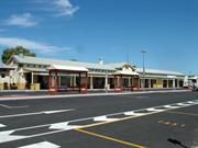
Bunbury Railway Station (fmr) is a single-storey brick structure with corrugated steel roof cladding comprises the main station building and detached toilet building designed in the Federation Free Classical style of architecture with strong influences of the Federation Arts and Crafts style in the detailing. It is a long single room width building with pitched roof and verandahs each side and a detached toilet building. The following description is extracted from the Heritage Council of Western Australia's Assessment Documentation: The place is now used as a bus terminal including a cafe and tourist bureau, the ground levels adjacent to the former platform edge having been raised to the level of the platform as part of the public garden-style landscaping of the former yards. The building complex is principally formed by a gable ended, 16 bay shed structure, 5.450 metres wide with a ceiling height of3.950 metres, principally of one room in width, with an entry-booking hall intersecting the shed form, asymmetrically, at the seventh bay from the north end. The roof at this intersection is raised 0.600 metres, and opposed to the general ridge line, thereby producing gables in the elongated facades that signpost the position of entry to the main hall. The elongated form is continued at the north end in the form of a detached lavatory block, formerly connected by a fenced rainwater tank yard. Similarly, at the southern end there was formerly a tank yard separating the main wing from a detached Lamp Room and Fuel Room block. On the east side, the platform roof is supported on rafters spanning between major purlins which are in turn supported on U-shaped bent steel portals which are cantilevered out of restraining blocks within the platform floor, and which are surmounted by steel rings supporting the inner ends of the purlins. These portals are fabricated from rolled steel railway track sections and are typical of the confident engineering improvisation found within many such railway structures of the era. Subsequent alterations include re-roofing from galvanised corrugated iron to asbestos to process-painted corrugated steel, uniform painting over of fairfaced brickwork walls and stone sills etc, demolition of 3 of 6 former chimneys and alteration of one survivor as a kitchen flue, removal of several partition cross walls and fireplaces, elimination of grade difference between platform and track levels, surrounding of verandah posts with brick armour-plinths, limited filling of verandahs with glazed weather screening at bus-boarding positions, reinstatement of former lost verandah lattice but without accompanying "capital" molds on posts, and, probably, replacement of posts from time to time. The building materials are principally corrugated steel roof cladding, on timber trussed roof structure (with decorative flourishes in timber), on clay brick walls with cavities, and timber floors, all on concrete plinths and footings, with the internal surfaces predominantly of plain plasterwork. The appearance and condition of the building to date is good and substantially in what must have been its original form, albeit of different colours and colour scheme.
Bunbury Railway Station was built in 1905 and replaced an earlier station building (1894) that was destroyed by fire. The Perth-Bunbury Railway line was formally opened on 8 September 1893, although trains had been running for some weeks before. The ceremony was performed by the Governor, Sir W. F. C. Robinson. The track ran along side what is now Blair Street to a station and marshalling yard east of the town. The completion of the Perth-Bunbury Railway also saw Bunbury connected to other parts of Western Australia as new lines were constructed. A government built railway between Boyanup and Bunbury was completed in March 1897 and in 1906, construction of a line between Darkan and Bunbury saw the Bunbury network connected with the Great Southern. These lines enabled the transport of timber, coal and bulky agriculture products to Bunbury, as well as bringing job opportunities and prosperity to the town and port. For the first year after the Perth-Bunbury line was built, passengers had to alight from the train in front of the Post Office. The need for a railway station was apparent and caused much debate in Bunbury as to where it should be located. Professional engineers recommended that the station be built on the lagoon site, necessitating major drainage works. However, many still considered that this site would have potential health hazards and that Bunbury would lose one of its most striking natural features. They wanted the railway station to be built at the foot of Bury Hill on land owned by the Mayor, William Spencer. There was a heated public meeting to decide the matter, which resulted in a tied vote (24 votes in favour of each). Mayor Spencer, who chaired the meeting, was called on to decide the matter. He chose the Bury Hill site and his supporters worked hard to get 150 names on a petition in his favour. However, the local decision was rejected by officials in Perth, and Premier Sir John Forrest told a public meeting in Bunbury on 19 October 1893 that the lagoon site had been selected on the best professional advice. He was personally amazed at opposition to the site as he believed the lagoon was an eyesore. Atkins and Law were awarded the contract to build the station by 23 September 1894 at a cost of £10,913/4/1. The majority of the budget was used on land reclamation, though at the end of the works, much of the swamp remained. The timber station building was opened on 14 November 1894 by Sir John Forrest. However, on 5 December 1904, the building was razed in a fire which had started in a lamp room at approximately 2am. The jarrah building was quickly engulfed in flames and the parcels office was all that could be saved. A new, brick, station building was completed the following year. Plans were prepared by the Public Works Department under the direction of Chief Architect, George Temple Poole. The station building comprised guards and porters rooms, offices for the permanent way staff, district superintendant, clerks, the foreman and the station master, as well as the booking hall, ticket office, parcel and luggage rooms and ladies’ waiting room. Associated structures included the lamp and fuel rooms, tank yard and gents and ladies’ latrines. Bus services were introduced to Bunbury in the mid-1960s. On 25 May 1985, Bunbury Railway Station received train passengers for the last time. The train line was moved out of the city and a new terminal was built at Picton. Ownership of the railway station was transferred from Westrail (formerly Western Australian Government Railways) to the City of Bunbury and the building was converted into commercial premises, the Bunbury Tourist Bureau, the bus terminal and cafe. This history is partly based on Heritage Council of Western Australia, ‘Register of Heritage Places: Bunbury Railway Station’, prepared by Ian Molyneux, 1997.
Restoration of a high standard was undertaken with only minor alterations. The chimneys were removed. Some relatively modern enclosures detract from its simplicity and painted walls would not have been part of the original detailing. Although no longer used as a Railway Station, the essential character has been retained to accommodate a new role.
Good. The building is in daily use for commercial purposes and appears to be well maintained.
| Reserve | Lot/Location | Plan/Diagram | Vol/Folio |
|---|---|---|---|
| 5 | D071676 5 | VOL1764FOL155 |
This information is provided voluntarily as a public service. The information provided is made available in good faith and is derived from sources believed to be reliable and accurate. However, the information is provided solely on the basis that readers will be responsible for making their own assessment of the matters discussed herein and are advised to verify all relevant representations, statements and information.
Carey St Bunbury
Fraser Street (fmr)
Bunbury
South West
Constructed from 1910 to 1953
| Type | Status | Date | Documents |
|---|---|---|---|
| Heritage List | Adopted | 15 Apr 2003 |
| Type | Status | Date | Documents |
|---|---|---|---|
| (no listings) |
| Type | Status | Date | Grading/Management | |
|---|---|---|---|---|
| Category | ||||
| Municipal Inventory | Adopted | 04 Sep 2001 | ||
| Municipal Inventory | Adopted | 31 Jul 1996 | Historic Site | |
| Library Id | Title | Medium | Year Of Publication |
|---|---|---|---|
| 7299 | Bunbury images : people and places. | Book | 2004 |
Historic Site
| Epoch | General | Specific |
|---|---|---|
| Original Use | SOCIAL\RECREATIONAL | Other Community Hall\Centre |
| Other Use | EDUCATIONAL | Housing or Quarters |
| Present Use | VACANT\UNUSED | Vacant\Unused |
| Type | General | Specific |
|---|---|---|
| Wall | TIMBER | Weatherboard |
| Roof | METAL | Corrugated Iron |
This information is provided voluntarily as a public service. The information provided is made available in good faith and is derived from sources believed to be reliable and accurate. However, the information is provided solely on the basis that readers will be responsible for making their own assessment of the matters discussed herein and are advised to verify all relevant representations, statements and information.
Constructed from 1910, Constructed from 1948
DEMOLISHED The Eastern Goldfields Fresh Air League was an important connection between the port city of Bunbury and the Goldfields and hinterland. The hostel was established by Syd Hocking, the managing director of the Kalgoorlie Miner and former mayor of Kalgoorlie, to provide affordable seaside accommodation for the children of the Goldfields and their families. In 1948, the CWA used the building for accommodation of country boys attending the local Bunbury High School. This was an important consideration to the success of a Government plan offering secure living away from home arrangements for rural youth who sought access to higher education opportunities.
DEMOLISHED
The Fresh Air League was founded by the managing director of the ‘Kalgoorlie Miner’ and former mayor of Kalgoorlie, Syd Hocking, who had arrived in Coolgardie from South Australia in 1893. Hocking wished to give children from the Goldfields the opportunity to experience the seaside, a welcome alternative to the usually harsh, dry and dusty summers in the Goldfields. Bunbury was one of the League’s favoured destinations and on 27 September 1911, the Fresh Air League purchased Lot 223, Reserve 13077, comprising just over two acres. The League had a large, sprawling dormitory style building erected on the site, with an iron roof, air vents and brick chimneys. Entry was via steps leading up to an entry room from the hillside. Sleeping quarters (dormitory) were sectioned off, divided into four, with two staff rooms in the middle on either side. Shower facilities were at the eastern end of the dormitory. There was also a large kitchen, servery area, large dining rooms, two staff rooms, and a laundry. Toilets were in a detached building. The matron and her family had separate quarters, with a private entry, comprising a sitting room, two bedrooms, a dining room and bathroom. Transport through railway corridors connected the Goldfields folk with the Bunbury seaside community, and strong and lasting business, personal and recreation links were formed between the two groups. During World War I, the windows were blacked out in case of air raids. The building was used as an isolation hospital during the (Spanish) influenza epidemic immediately following World War I. In 1948, when the CWA Boy’s Hostel lease on Sandridge Park expired, the Government purchased the Fresh Air League Building and renovated it at a cost of £5,000 It was then named ‘Craig House’ and accommodated 58 boys (and two house masters) who attended Bunbury High School. The hostel was operated by the CWA and rent was £120 per annum. The Government subsidized each boy 2/6 a week. Mrs Bess Sykes was matron for over ten years, occasionally assisted by Mrs Kelly. Matron Hayward replaced Matron Sykes on her retirement in 1960, just after major renovations had been completed.
DEMOLISHED
No visible remains.
This information is provided voluntarily as a public service. The information provided is made available in good faith and is derived from sources believed to be reliable and accurate. However, the information is provided solely on the basis that readers will be responsible for making their own assessment of the matters discussed herein and are advised to verify all relevant representations, statements and information.
15 Carey St Bunbury
Bunbury
South West
Constructed from 1870
| Type | Status | Date | Documents |
|---|---|---|---|
| Heritage List | Adopted | 15 Apr 2003 |
| Type | Status | Date | Documents |
|---|---|---|---|
| RHP - To be assessed | Current | 31 Mar 2017 |
| Type | Status | Date | Grading/Management | |
|---|---|---|---|---|
| Category | ||||
| Register of the National Estate | Permanent | 26 May 1981 | ||
| Classified by the National Trust | Classified | 04 Aug 1980 | ||
| Municipal Inventory | Adopted | 31 Jul 1996 | Considerable Significance | |
• The place has rarity value as it is one of the few houses to survive the pre gold boom period.
• The place historic value as it serves as a link illustrating the architectural evolution of local homes.
The Shire of Bunbury Municipal Inventory states: ‘Brick house of long, simple rectangular plan with a corrugated iron roof, detached lean to front verandah and decorative timber eave fascia. Elegance of details and of door and window proportions would have made this one of the better simple townhouse of its time. Rendered quoins to windows and doors.’
The Shire of Bunbury Municipal Inventory states: ‘One of the few surviving houses from the 1870’s in the CBD area (Bunbury). At one time, it was Government housing used to accommodate the Harbour Master/pilot and their families.’
High
Good
Individual Building or Group
| Epoch | General | Specific |
|---|---|---|
| Original Use | RESIDENTIAL | Single storey residence |
| Present Use | RESIDENTIAL | Single storey residence |
| Style |
|---|
| Victorian Georgian |
| Type | General | Specific |
|---|---|---|
| Wall | BRICK | Face Brick |
| Roof | METAL | Corrugated Iron |
| General | Specific |
|---|---|
| DEMOGRAPHIC SETTLEMENT & MOBILITY | Settlements |
This information is provided voluntarily as a public service. The information provided is made available in good faith and is derived from sources believed to be reliable and accurate. However, the information is provided solely on the basis that readers will be responsible for making their own assessment of the matters discussed herein and are advised to verify all relevant representations, statements and information.

Constructed from 1870
House, 15 Carey Street, a single storey brick and iron house dating from c 1870 has cultural heritage significance for the following reasons: the place is a substantial example of the Victorian Georgian style of architecture; the place is one of the earliest houses from the town centre which survived the development of the gold boom period and serves to demonstrate the architectural evolution of local town house forms; the place has landmark qualities and contributes significantly to the streetscape and the community's sense of place; and, at one time, the house was owned by the Harbour and Lights Department and was home to a number of harbour masters and their families.
House, 15 Carey Street is a single storey brick and iron house constructed in the Victorian Georgian style of architecture. The walls are red face brick with rendered quoins and painted face brick. The roof is hipped and clad with corrugated iron with a decorative timber eave fascia. The verandah is under a separate corrugated iron roof supported by timber posts. The symmetrical front façade has a central front door flanked on either side by timber French doors and double hung sash windows. A small chimney is evident at the rear. The house is situated at street level. There is a timber picket fence to the front boundary line.
Carey Street, named in the 1840s for Nicholas Carey who arrived in Western Australia in 1835, is one of Bunbury’s earliest residential streets. House, 15 Carey Street was built c 1870 and is one of the few homes from this period surviving in the Bunbury central business district. In the early years of the 20th century, House, 15 Carey Street was occupied by a Mrs Dawes. She remembered (in an oral history interview) ‘beautiful jarrah floors one inch thick’, evidence of a cellar and buttressed walls. By the 1930s, the house was owned by the Western Australian Government to house government employees. The Douglas family, who lived there in 1931, was replaced by the Cooke family in the same year. In 1951, the Harbour and Lights Department was listed as the owner. The occupant, Bunbury Harbour Master Fred Gilmore, paid the garbage and excess water charges directly to Bunbury Council. The Gilmore family had been living in the house since c. 1940. Other harbour masters to have lived at House, 15 Carey Street include Captain Reid and Captain Donaldson.
High degree of integrity (original intent clear, current use compatible, high long term sustainability). High degree of authenticity with much original fabric remaining. (These statements based on street survey only).
Condition assessed as good (assessed from streetscape survey only).
| Reserve | Lot/Location | Plan/Diagram | Vol/Folio |
|---|---|---|---|
| 211 | P300656 211 | VOL1481FOL352 |
This information is provided voluntarily as a public service. The information provided is made available in good faith and is derived from sources believed to be reliable and accurate. However, the information is provided solely on the basis that readers will be responsible for making their own assessment of the matters discussed herein and are advised to verify all relevant representations, statements and information.
18 Carey St Bunbury
was 14 Carey St - renumbered
Kroon Legal Offices
Rock 'N' Roll High School (fmr)
Bunbury
South West
Constructed from 1888
| Type | Status | Date | Documents |
|---|---|---|---|
| Heritage List | Adopted | 15 Apr 2003 |
| Type | Status | Date | Documents |
|---|---|---|---|
| (no listings) |
| Type | Status | Date | Grading/Management | |
|---|---|---|---|---|
| Category | ||||
| Municipal Inventory | Adopted | 31 Jul 1996 | Moderate Significance | |
Individual Building or Group
| Epoch | General | Specific |
|---|---|---|
| Original Use | RESIDENTIAL | Single storey residence |
| Present Use | EDUCATIONAL | Other |
| Style |
|---|
| Victorian Georgian |
| Type | General | Specific |
|---|---|---|
| Roof | METAL | Corrugated Iron |
| Other | STONE | Local Stone |
| Wall | BRICK | Common Brick |
| Wall | PLASTER | Other Plaster |
| General | Specific |
|---|---|
| DEMOGRAPHIC SETTLEMENT & MOBILITY | Land allocation & subdivision |
This information is provided voluntarily as a public service. The information provided is made available in good faith and is derived from sources believed to be reliable and accurate. However, the information is provided solely on the basis that readers will be responsible for making their own assessment of the matters discussed herein and are advised to verify all relevant representations, statements and information.

Constructed from 1888, Constructed from 1886
House (fmr), 18 Carey Street, a single storey brick and iron former house now commercial building dating from 1886 has cultural heritage significance for the following reasons: the place is a good example of the Victorian Georgian style of architecture; the place has landmark qualities and contributes significantly to the streetscape and the community's sense of place.
House (fmr), 18 Carey Street is a single storey brick and iron former house constructed in the Victorian Georgian style of architecture. The place has, in 2010, been restored and an addition constructed to the rear. The walls are constructed in Flemish Bond brickwork and have had later paint removed and been retuckpointed. The roof is hipped and clad with corrugated iron. The verandah is under a separate corrugated iron roof supported by timber posts. The symmetrical front façade has a central front door with fanlight flanked on either side by timber framed double hung sash windows. At the rear of the building is a face brick (limestone coloured) extension with a gabled corrugated iron roof. A verandah has been added to the side of the building providing cover to an access ramp. There is a steel fence to the front boundary line.
House, 18 Carey Street was built between 1866 and 1888. It is listed in the 1889 rate books. From 1886 until 1897, the land was owned by Henry Thomas, a carter. It is assumed that the house was built for Thomas. Originally, the house was numbered 14 Carey Street and is one of the oldest houses in the area. The house has had a number of uses in recent years, including a Rock ‘n’ Roll High School.
Medium to High degree of integrity (original intent still clear despite addition to rear, current use compatible, high long term sustainability). Medium to High degree of authenticity with much original fabric remaining. (These statements based on street survey only).
Condition assessed as good (assessed from streetscape survey only).
| Reserve | Lot/Location | Plan/Diagram | Vol/Folio |
|---|---|---|---|
| 3 | D005644 3 | VOL816FOL65 |
This information is provided voluntarily as a public service. The information provided is made available in good faith and is derived from sources believed to be reliable and accurate. However, the information is provided solely on the basis that readers will be responsible for making their own assessment of the matters discussed herein and are advised to verify all relevant representations, statements and information.
2 Carey St Bunbury
Bunbury
South West
Constructed from 1910
| Type | Status | Date | Documents |
|---|---|---|---|
| Heritage List | Adopted | 15 Apr 2003 |
| Type | Status | Date | Documents |
|---|---|---|---|
| (no listings) |
| Type | Status | Date | Grading/Management | |
|---|---|---|---|---|
| Category | ||||
| Municipal Inventory | Adopted | 31 Jul 1996 | Moderate Significance | |
Individual Building or Group
| Epoch | General | Specific |
|---|---|---|
| Present Use | RESIDENTIAL | Single storey residence |
| Original Use | RESIDENTIAL | Single storey residence |
| Style |
|---|
| Federation Bungalow |
| Type | General | Specific |
|---|---|---|
| Roof | METAL | Corrugated Iron |
| Wall | TIMBER | Weatherboard |
| General | Specific |
|---|---|
| DEMOGRAPHIC SETTLEMENT & MOBILITY | Land allocation & subdivision |
This information is provided voluntarily as a public service. The information provided is made available in good faith and is derived from sources believed to be reliable and accurate. However, the information is provided solely on the basis that readers will be responsible for making their own assessment of the matters discussed herein and are advised to verify all relevant representations, statements and information.

Constructed from 1910
House, 2 Carey Street, a single storey timber and iron house has cultural heritage significance for the following reasons: the place is a good example of the Federation Bungalow style of architecture; the place has landmark qualities and contributes significantly to the streetscape and the community's sense of place.
House, 2 Carey Street is a single storey timber and iron house constructed in the Federation Bungalow style of architecture. The walls are timber framed and clad with timber weatherboards and flat fibre cement sheeting. The roof is hipped and clad with corrugated iron. The verandah is under a continuous corrugated iron roof supported by timber posts with timber balustrade. The verandah is enclosed at one end with timber lattice and at the other with fibre cement sheeting and timber weatherboards. The front façade has a central front door flanked on either side by timber framed double hung sash windows. There is a rendered corbelled chimney with chimney pots evident. The house is elevated from the street level and a set of concrete steps lead up to the verandah level. There is a timber picket fence in line with the front of the house.
Carey Street, named in the 1840s for Nicholas Carey who arrived in Western Australia in 1835, is one of Bunbury’s earliest residential streets. Lot 4 on the corner of Carey and Malcolm Street was advertised for sale on 4 September 1907 by W. J (Jack) Buswell, the son of a ticket-of-leaver and prominent businessman who owned a brick factory. Buswell was on the Board of Health in 1907, was a committee member on the National Referendum Committee in 1916 and served for a term on the Bunbury Municipal Council in 1915-16 and was re-elected in 1922. The date of construction of House, 2 Carey Street is not known. It is thought to have been built c. 1910. Long term occupants of House, 2 Carey Street were the Larkins family. In 1931, the house was listed in the Rate Book as 17 Carey Street and was owned and occupied by Horace Larkins. Horace was still the owner in 1941 and by 1951, ownership had passed to Constance Larkins, although Horace was still the official occupant in that year.
High degree of integrity (original intent clear, current use compatible, high long term sustainability). High degree of authenticity with much original fabric remaining. (These statements based on street survey only).
Condition assessed as good (assessed from streetscape survey only).
| Reserve | Lot/Location | Plan/Diagram | Vol/Folio |
|---|---|---|---|
| 4 |
This information is provided voluntarily as a public service. The information provided is made available in good faith and is derived from sources believed to be reliable and accurate. However, the information is provided solely on the basis that readers will be responsible for making their own assessment of the matters discussed herein and are advised to verify all relevant representations, statements and information.
5 Carey St Bunbury
Bunbury
South West
Constructed from 1908
| Type | Status | Date | Documents |
|---|---|---|---|
| Heritage List | Adopted | 15 Apr 2003 |
| Type | Status | Date | Documents |
|---|---|---|---|
| (no listings) |
| Type | Status | Date | Grading/Management | |
|---|---|---|---|---|
| Category | ||||
| Municipal Inventory | Adopted | 31 Jul 1996 | Moderate Significance | |
| Name | Type | Year From | Year To |
|---|---|---|---|
| Association to | Architect | - | - |
Individual Building or Group
| Epoch | General | Specific |
|---|---|---|
| Original Use | RESIDENTIAL | Single storey residence |
| Present Use | RESIDENTIAL | Single storey residence |
| Style |
|---|
| Federation Bungalow |
| Type | General | Specific |
|---|---|---|
| Wall | TIMBER | Weatherboard |
| Roof | METAL | Corrugated Iron |
| General | Specific |
|---|---|
| DEMOGRAPHIC SETTLEMENT & MOBILITY | Land allocation & subdivision |
This information is provided voluntarily as a public service. The information provided is made available in good faith and is derived from sources believed to be reliable and accurate. However, the information is provided solely on the basis that readers will be responsible for making their own assessment of the matters discussed herein and are advised to verify all relevant representations, statements and information.

Constructed from 1910
House, 5 Carey Street, a single storey timber and iron house has cultural heritage significance for the following reasons: the place is a fine example of the Federation Bungalow style of architecture; the place has landmark qualities and contributes significantly to the streetscape and the community's sense of place.
House, 5 Carey Street is a single storey timber and iron house constructed in the Federation Bungalow style of architecture. The walls are timber framed and clad with timber weatherboards. The roof is hipped and clad with corrugated iron. Two hipped sections of the roof with a box gutter are located to the rear of the house. A skylight has been added to the roof. The verandah is under a separate corrugated iron bullnose roof supported by timber posts with decorative timber valance and timber balustrade. The verandah extends to the western side of the house. The symmetrical front façade has a central front door with sidelights flanked on either side by timber framed double hung sash windows. There is a face brick and rendered chimney evident. The house is situated on a sloping block. There is a timber picket fence to the front boundary line which follows the sloping elevation of the block. The land surrounding the house has been subdivided and two storey brick units have been constructed.
Carey Street, named in the 1840s for Nicholas Carey who arrived in Western Australia in 1835, is one of Bunbury’s earliest residential streets. Lots in this area of Carey Street were advertised for sale from 1907 and it is thought that House, 5 Carey Street was built soon after. The Swensen family owned and occupied House, 5 Carey Street for many years. A Swensen was listed as the owner in 1921, Elizabeth Swensen in 1941 and Alfred Swensen in 1951. It is believed that the builders were Nilsson and Banting (2001 MHI).
High degree of integrity (original intent clear, current use compatible, high long term sustainability). High degree of authenticity with much original fabric remaining. (These statements based on street survey only). Note: The surrounding site context of the house has been altered.
Condition assessed as good (assessed from streetscape survey only).
| Reserve | Lot/Location | Plan/Diagram | Vol/Folio |
|---|---|---|---|
| SL11 | S045499 | VOL2570FOL995 |
This information is provided voluntarily as a public service. The information provided is made available in good faith and is derived from sources believed to be reliable and accurate. However, the information is provided solely on the basis that readers will be responsible for making their own assessment of the matters discussed herein and are advised to verify all relevant representations, statements and information.
Carey St SE cnr Victoria St Bunbury
fmr Ommanney St
Bunbury
South West
Constructed from 1879
| Type | Status | Date | Documents |
|---|---|---|---|
| (no listings) |
| Type | Status | Date | Documents |
|---|---|---|---|
| (no listings) |
| Type | Status | Date | Grading/Management | |
|---|---|---|---|---|
| Category | ||||
| Municipal Inventory | Adopted | 31 Jul 1996 | Historic Site | |
Historic Site
| Epoch | General | Specific |
|---|---|---|
| Original Use | COMMERCIAL | Hotel, Tavern or Inn |
| Present Use | VACANT\UNUSED | Vacant\Unused |
| Style |
|---|
| Victorian Filigree |
| Type | General | Specific |
|---|---|---|
| Roof | METAL | Corrugated Iron |
| Wall | BRICK | Two-tone Brick |
| General | Specific |
|---|---|
| OCCUPATIONS | Hospitality industry & tourism |
This information is provided voluntarily as a public service. The information provided is made available in good faith and is derived from sources believed to be reliable and accurate. However, the information is provided solely on the basis that readers will be responsible for making their own assessment of the matters discussed herein and are advised to verify all relevant representations, statements and information.
Constructed from 1879
DEMOLISHED The Pier Hotel was one of the hotels built in Bunbury in the late colonial period. The views from the first floor made the hotel popular with visitors.
DEMOLISHED
The Pier Hotel was one of the hotels built in Bunbury during the colonial period (pre 1900). It was built c 1879. D Flood was the publican in 1895, but soon the licence passed to Harold Colville Gordon. Gordon built another hotel next door in 1895, which he called Gordon’s Hotel (B211), to cater for the increase of visitors to Bunbury as a result of the gold rush. It has been recorded that guests would stay at the Pier Hotel as it offered better views of Koombana Bay but that they would eat at Gordon’s Hotel. When the Sailor's Rest/Mission to Seamen was first established (B200), they rented rooms at the Pier Hotel for visiting sailors before building their own premises. The Ancient Order of Druids met at the Pier and Vivien May made mention of it in her journal of her visit to Western Australia in 1901. The Pier Hotel was a two tone, double storey hotel with upper and lower verandahs in a symmetrical layout. Four windows were evenly spaced across the first floor. Entrance was through a central door flanked by a window on either side. The Pier Hotel was demolished in 1954.
DEMOLISHED
DEMOLISHED
This information is provided voluntarily as a public service. The information provided is made available in good faith and is derived from sources believed to be reliable and accurate. However, the information is provided solely on the basis that readers will be responsible for making their own assessment of the matters discussed herein and are advised to verify all relevant representations, statements and information.
13 Carey Street Bunbury
Bunbury
South West
| Type | Status | Date | Documents |
|---|---|---|---|
| Heritage List | Adopted | 31 Jan 2023 |
| Type | Status | Date | Documents |
|---|---|---|---|
| (no listings) |
| Type | Status | Date | Grading/Management | |
|---|---|---|---|---|
| Category | ||||
| Local Heritage Survey | Adopted | 31 Jan 2023 | Some Significance | |
Individual Building or Group
| Epoch | General | Specific |
|---|---|---|
| Present Use | COMMERCIAL | Other |
| Original Use | RESIDENTIAL | Single storey residence |
| Style |
|---|
| Federation Bungalow |
| Type | General | Specific |
|---|---|---|
| Roof | METAL | Corrugated Iron |
| Wall | BRICK | Face Brick |
| General | Specific |
|---|---|
| OCCUPATIONS | Domestic activities |
| OCCUPATIONS | Commercial & service industries |
This information is provided voluntarily as a public service. The information provided is made available in good faith and is derived from sources believed to be reliable and accurate. However, the information is provided solely on the basis that readers will be responsible for making their own assessment of the matters discussed herein and are advised to verify all relevant representations, statements and information.

Constructed from 1903 to 1910
Medical Office, 13 Carey Street, has cultural heritage significance for the following reasons: • The place, as part of a group of four houses (No. 13, 15, 16, 18 Carey Street), collectively help to represent the character of early residential development close to the business centre of Bunbury. • The place has aesthetic significance as a representative example of a Federation era dwelling. • The place is representative of the trend to convert early residential buildings into commercial premises.
Medical Office, 13 Carey Street, is a single storey brick building with a corrugated steel hip roof, designed in the Federation Bungalow style of architecture. The hip roof has a rendered and face brick chimney with a second smooth rendered chimney set to the rear. The street elevation is Flemish bond, face brick above a stone foundation. The side walls are rendered. The building has a front lean-to verandah supported by square timber columns with a tiled concrete base. The four-paneled timber framed front door has sidelights and highlights. The front door is flanked by timber framed double hung windows. The place is enclosed to the front by a timber picket fence with tall timber posts. A concrete entry ramp with steel balustrades leads towards the front door. To the rear is a timber weatherboard lean-to with an attached verandah. There is a mature tree to the front verge. The mixed use streetscape has commercial and professional suites.
At the beginning of the 1890s, Bunbury had a population of only 572. By the end of that decade, the population had risen to 2,970 – reflecting the rate of increase experienced by the colony as a whole following the discovery of significant gold deposits. This was matched by improvements in infrastructure, including the opening of the Perth to Bunbury railway line in 1893 and significant development of the port. From this time on the town developed not only as an important regional centre, but also as a seaside tourist resort. Despite the adverse impact of war and depression, Bunbury continued to experience residential and business development during the Inter-War era, and the population reached around 6,000 in 1939. The ongoing development and consolidation of the town over time continues to be reflected in its local heritage places. An early twentieth century photographic view over Bunbury shows a building at 5 Victoria Street (known to have been constructed in 1903), while the site of 13 Carey Street is still vacant. The latter had been developed by c.1910, when a similar photograph clearly shows a building corresponding to the form and position of the current house (noting that the place appears to have originally had a bull-nosed verandah). The Sinclair family were long-term residents of Carey Street and are known to have moved into the street at some stage between 1906 and 1910. Members of the family living here included John Thomas Sinclair, his wife Eleanor, and at least some of their 9 children (born c.1889-1908). At the time of his retirement, it was reported that John Sinclair had worked for the Harbours and Lights Department from 1900-1933, serving as coxswain of Bunbury’s pilot boat for 33 years and as the main lighthouse keeper from 1918. In a newspaper notice in 1919 the Sinclair family home in Carey Street was referred to as ‘Ellensdale,’ and in the Electoral Rolls of the late 1920s, some members of the family were more specifically identified as residents of 8 Carey Street (now known as 13 Carey Street). John and Eleanor’s daughter, Stella Jane Sinclair (c.1907-1991) remained at 13 Carey Street for much of her life. In 1936, Bunbury underwent a major reallocation of street numbers which resulted in the property changing from 8 Carey Street to its present address of 13 Carey Street. Aerial imagery suggests that the place was converted to a commercial premises in c.2007 with the backyard being converted to a bitumen parking lot. Since c.2015, the place has been utilised as the medical office of the 'Sleep and Snore Solutions'.
Integrity: Medium Authenticity: Medium Date of survey: 2/01/2022
Good
| Ref ID No | Ref Name | Ref Source | Ref Date |
|---|---|---|---|
| BA533/255: View over Bunbury from Lighthouse Hill | State Library of Western Australia | ca.1910 | |
| 1498B: Panorama over Bunbury harbour and along town foreshore, | State Library of Western Australia | post 1903 | |
| Newspaper | South Western Times - p5 | 29 April 1933 | |
| Electoral Records | Western Australian Electoral Records | ||
| City of Bunbury Local Studies Collection | City of Bunbury Rate Books | 1926/27 and 1951 | |
| • Online family trees (ancestry.com.au) |
| Reserve | Lot/Location | Plan/Diagram | Vol/Folio |
|---|---|---|---|
| 210 | P300656 | 2095/302 |
This information is provided voluntarily as a public service. The information provided is made available in good faith and is derived from sources believed to be reliable and accurate. However, the information is provided solely on the basis that readers will be responsible for making their own assessment of the matters discussed herein and are advised to verify all relevant representations, statements and information.
16 Carey Street Bunbury
Bunbury
South West
| Type | Status | Date | Documents |
|---|---|---|---|
| Heritage List | Adopted | 31 Jan 2023 |
| Type | Status | Date | Documents |
|---|---|---|---|
| (no listings) |
| Type | Status | Date | Grading/Management | |
|---|---|---|---|---|
| Category | ||||
| Local Heritage Survey | Adopted | 31 Jan 2023 | Some Significance | |
Individual Building or Group
| Epoch | General | Specific |
|---|---|---|
| Present Use | COMMERCIAL | Other |
| Original Use | RESIDENTIAL | Single storey residence |
| Style |
|---|
| Federation Bungalow |
| Type | General | Specific |
|---|---|---|
| Roof | METAL | Corrugated Iron |
| Wall | BRICK | Rendered Brick |
| General | Specific |
|---|---|
| OCCUPATIONS | Commercial & service industries |
| OCCUPATIONS | Domestic activities |
This information is provided voluntarily as a public service. The information provided is made available in good faith and is derived from sources believed to be reliable and accurate. However, the information is provided solely on the basis that readers will be responsible for making their own assessment of the matters discussed herein and are advised to verify all relevant representations, statements and information.

Constructed from 1900
Medical Office, 16 Carey Street, has cultural heritage significance for the following reasons: • The place, as part of a group of four houses (No. 13, 15, 16, 18 Carey Street), collectively help to represent the character of early residential development close to the business centre of Bunbury. • The place has aesthetic significance as a representative example of a Federation era dwelling. • The place is representative of the trend to convert early residential buildings into commercial premises.
Medical Office, 16 Carey Street, is a single storey rendered masonry building with a corrugated steel hip and gable roof displaying characteristics of the Federation Bungalow style of architecture. The roof has two decorative rendered chimneys set behind the roof pitch. A third simple chimney is rendered and painted. The street elevation has a rendered and painted finish with a decorative string coursing at approximately 2100mm high. The facade features a gable bay with simple timber decoration to the gable end. A projecting bay window addresses the street with the decorative string course forming window labels. The building has a front lean- to verandah supported by square timber columns with a tiled concrete base. The four-paneled timber framed front door has sidelights and highlights. Pairs of timber framed double hung windows are located adjacent to the front door. To the rear is a weatherboard lean-to. To the east is a paved driveway with a bitumen parking lot to the rear. There is a mature tree to the front verge. The mixed use streetscape has commercial and professional suites.
At the beginning of the 1890s, Bunbury had a population of only 572. By the end of that decade, the population had risen to 2,970 – reflecting the rate of increase experienced by the colony as a whole following the discovery of significant gold deposits. This was matched by improvements in infrastructure, including the opening of the Perth to Bunbury railway line in 1893 and significant development of the port. From this time on the town developed not only as an important regional centre, but also as a seaside tourist resort. Despite the adverse impact of war and depression, Bunbury continued to experience residential and business development during the Inter-War era, and the population reached around 6,000 in 1939. The ongoing development and consolidation of the town over time continues to be reflected in its local heritage places. The following newspaper item indicates that Carey Street was a focus of residential development in the late nineteenth century (despite flooding in winter): Houses were going up in all directions in Carey-street, and yet people could not get to their places in the winter time except by climbing fences, etc. A photographic view over Bunbury dated c.1895-1900 shows a house corresponding to the form and position of 16 Carey Street. The readily available evidence suggests that the house changed ownership on a number of occasions and was frequently used as a rental property. Owners recorded in the available Rates Book included Ephraim Mayo Clarke, merchant (turn of the century) and Herbert Thomson Anderson, motor proprietor/farmer (1920s/1930s). In 1936, Bunbury underwent a major reallocation of street numbers which resulted in the property changing from 7 Carey Street to its present address of 16 Carey Street. Aerial imagery suggests that the place was converted to a commercial premises in c.2012 with the backyard being converted to a bitumen parking lot. Since c.2012, the place has been utilised as the medical office of the 'Mr. Paul Armanasco' podiatric surgeon.
Integrity: Low Authenticity: High-Medium Date of survey: 2/01/2022
Good
| Ref ID No | Ref Name | Ref Source | Ref Date |
|---|---|---|---|
| BA1344/85: Bunbury | State Library of Western Australia | ca.1895-1900 | |
| Place records for 15 Carey Street (Place No 0334) and 18 Carey Street (Place No 06606) | InHerit Database | ||
| City of Bunbury Rate Books | City of Bunbury Local Studies Collection | 1899/1900 1926/27 | |
| BA533/255: View over Bunbury from Lighthouse Hill | State Library of Western Australia | ca.1910 | |
| Newspaper | Southern Time - p3 | 21 December 1897 |
| Reserve | Lot/Location | Plan/Diagram | Vol/Folio |
|---|---|---|---|
| 4 | 5644 | 1754/542 |
This information is provided voluntarily as a public service. The information provided is made available in good faith and is derived from sources believed to be reliable and accurate. However, the information is provided solely on the basis that readers will be responsible for making their own assessment of the matters discussed herein and are advised to verify all relevant representations, statements and information.
verge Carob St Bunbury
Ceratonia siliqua
Bunbury
South West
Constructed from 1900
| Type | Status | Date | Documents |
|---|---|---|---|
| (no listings) |
| Type | Status | Date | Documents |
|---|---|---|---|
| (no listings) |
| Type | Status | Date | Grading/Management | |
|---|---|---|---|---|
| Category | ||||
| Municipal Inventory | Adopted | 31 Jul 1996 | Some Significance | |
| Municipal Inventory | Adopted | 04 Sep 2001 | ||
Tree
| Epoch | General | Specific |
|---|---|---|
| Present Use | PARK\RESERVE | Park\Reserve |
| Original Use | FARMING\PASTORAL | Other |
This information is provided voluntarily as a public service. The information provided is made available in good faith and is derived from sources believed to be reliable and accurate. However, the information is provided solely on the basis that readers will be responsible for making their own assessment of the matters discussed herein and are advised to verify all relevant representations, statements and information.
Constructed from 1900
Mature Carob Trees, Carob Street, were planted by a local business identity, William Gibson, as a windbreak to protect his vineyard. The vineyard and winery, originally owned by E.M. Clarke, was an early rural fringe activity.
Described as a "Mediterranean Horn-Like Pod Tree". Large tree with dense green foliage which create a pleasant and unusual streetscape.
A row of four carob trees was planted by William Gibson as a windbreak for his vineyard c 1900. The vineyard had been established by Ephraim Mayo Clarke in partnership with Dr J A O’Meehan by 1888. It was one of the earliest vineyards in the South West and produced such products as “Punch Bowl” wine, which was sold in Clarke’s store in Bunbury. The street was later named Carob Street for the trees.
Not native to the area. Excellent examples of the species.
Appear healthy and casts plenty of seeds which are easily propagated.
This information is provided voluntarily as a public service. The information provided is made available in good faith and is derived from sources believed to be reliable and accurate. However, the information is provided solely on the basis that readers will be responsible for making their own assessment of the matters discussed herein and are advised to verify all relevant representations, statements and information.
11 Charles St Bunbury
Bunbury
South West
Constructed from 1900, Constructed from 2000
| Type | Status | Date | Documents |
|---|---|---|---|
| Heritage List | Adopted | 15 Apr 2003 |
| Type | Status | Date | Documents |
|---|---|---|---|
| (no listings) |
| Type | Status | Date | Grading/Management | |
|---|---|---|---|---|
| Category | ||||
| Municipal Inventory | Adopted | 31 Jul 1996 | Moderate Significance | |
Individual Building or Group
| Epoch | General | Specific |
|---|---|---|
| Present Use | RESIDENTIAL | Single storey residence |
| Original Use | RESIDENTIAL | Single storey residence |
| Style |
|---|
| Federation Arts and Crafts |
| Type | General | Specific |
|---|---|---|
| Other | TIMBER | Other Timber |
| Wall | TIMBER | Weatherboard |
| Wall | BRICK | Common Brick |
| Roof | METAL | Corrugated Iron |
| General | Specific |
|---|---|
| DEMOGRAPHIC SETTLEMENT & MOBILITY | Land allocation & subdivision |
| OCCUPATIONS | Domestic activities |
This information is provided voluntarily as a public service. The information provided is made available in good faith and is derived from sources believed to be reliable and accurate. However, the information is provided solely on the basis that readers will be responsible for making their own assessment of the matters discussed herein and are advised to verify all relevant representations, statements and information.

Constructed from 1900
House, 11 Charles Street, a single storey timber and iron house has cultural heritage significance for the following reasons: the place is an example of the Federation Bungalow style of architecture; the place has landmark qualities and contributes to the streetscape and the community's sense of place.
House, 11 Charles Street is a single storey timber and iron house constructed in the Federation Bungalow style of Architecture. The walls are timber framed and clad with timber weatherboards. The roof is hipped and clad with corrugated iron (note: additional gable added to roof as feature since earlier MI photos taken). The verandah is under a separate corrugated iron roof supported by timber posts with timber ornamental brackets. (note: verandah appears to have been extended around building at a later date). The asymmetrical front façade has a front door with side and fanlights flanked on one side by a timber framed double hung sash window. The protruding front room has a gabled roof with decorative timber gable screen and finial and double casement windows with an awning. There is a face brick chimney with rendered corbelling evident. The house is situated at street level. There is a timber picket fence to the front boundary line.
Charles Street was originally a narrow lane owned by Charles Hastie, who had a number of disputes over access and ownership with Charles Spencer. When the lane was widened and lengthened to become a public thoroughfare it was named after both men. Charles Street is located in one of Bunbury’s earliest residential areas. The date of construction of House, 11 Charles Street is has not been determined. It is thought to have been built c 1900. By 1921, House, 11 Charles Street was owned by William Brittain, who owned a number of residential properties throughout Bunbury, including the three attached houses at 20-24 Charles Street. At that time, it was occupied by a Mr Biesol, a labourer. In 1931, House, 11 Charles Street was owned and occupied by Harold Pain. Stephen Maslen was the owner and occupier in 1941. By 1951, the house was again a rental property, owned by Eleanor Smith who lived in South Australia, and leased by A E Anderson.
High degree of integrity (original intent clear, current use compatible, high long term sustainability). Medium degree of authenticity - alterations but with much original fabric remaining (These statements based on street survey only).
Condition assessed as good (assessed from streetscape survey only).
| Reserve | Lot/Location | Plan/Diagram | Vol/Folio |
|---|---|---|---|
| 1 | D002437 1 | VOL1355FOL203 |
This information is provided voluntarily as a public service. The information provided is made available in good faith and is derived from sources believed to be reliable and accurate. However, the information is provided solely on the basis that readers will be responsible for making their own assessment of the matters discussed herein and are advised to verify all relevant representations, statements and information.
20, 22 & 24 Charles St Bunbury
Bunbury
South West
Constructed from 1900
| Type | Status | Date | Documents |
|---|---|---|---|
| Heritage List | Adopted | 15 Apr 2003 |
| Type | Status | Date | Documents |
|---|---|---|---|
| (no listings) |
| Type | Status | Date | Grading/Management | |
|---|---|---|---|---|
| Category | ||||
| Municipal Inventory | Adopted | 31 Jul 1996 | Considerable Significance | |
Individual Building or Group
| Epoch | General | Specific |
|---|---|---|
| Original Use | RESIDENTIAL | Single storey residence |
| Present Use | RESIDENTIAL | Conjoined residence |
| Type | General | Specific |
|---|---|---|
| Wall | BRICK | Common Brick |
| Roof | METAL | Corrugated Iron |
| Other | METAL | Cast Iron |
| Other | TIMBER | Other Timber |
This information is provided voluntarily as a public service. The information provided is made available in good faith and is derived from sources believed to be reliable and accurate. However, the information is provided solely on the basis that readers will be responsible for making their own assessment of the matters discussed herein and are advised to verify all relevant representations, statements and information.

Constructed from 1900
Attached House, 20 Charles Street, one of a set of three (with 22 and 24 Charles Street), single storey, brick and iron terraces has cultural heritage significance for the following reasons: the place is a fine example of the Federation Queen Anne style of architecture; the place has landmark qualities and contributes significantly to the streetscape and the community's sense of place; the place is an intergral part of the Stirling Street Precinct.
Attached House, 20 Charles Street is one of a set of three (with 22 and 24 Charles Street), single storey, brick and iron terraces with an overall asymmetrical facade designed as an example of the Federation Queen Anne style of architecture. The walls are rendered brick. The terraces are under one continuous roof. The roof is hipped and gabled with decorative timber elements to gable ends and clad with corrugated iron. The façade is asymmetrical. No 20 has a projecting room with gable and finial, and two double hung sash windows under an awning. The front door with fan and sidelight is recessed in line with the other two houses. Numbers 22 and 24 have their front doors with fan and sidelight set to one side flanked by two double hung sash windows. The separate verandah is supported by timber posts with decorative wrought iron brackets which had previously been removed. The dividing parapet walls are visible through the verandah roof. There are two rendered corbelled chimneys evident. There is a timber picket fence to the front boundary line.
Charles Street was originally a narrow lane owned by Charles Hastie, who had a number of disputes over access and ownership with Charles Spencer. When the lane was widened and lengthened to become a public thoroughfare it was named after both men. Charles Street is located in one of Bunbury’s earliest residential areas. The date of construction of the attached houses at 20, 22 and 24 Charles Street is not known. The houses are thought to have been constructed c 1900 as rental accommodation for Bunbury’s rapidly expanding population. No entry for the lot could be found in the 1899 rate book. In 1921, William Brittain was listed as the owner of four properties on Lot 9/10. William Brittain owned a number of rental properties throughout Bunbury at this time, including the house at 11 Charles Street. The Estate of William Brittain was listed as the owner in 1931, by at which time there were only three houses listed on the lot. The houses were numbered 15, 17 and 19 Charles Street and were occupied by Arthur Sutcliffe, C J Anderson and A Winter respectively. Previous occupants of No 17 and No 19 were a Mr Thomas and R Goode. By 1941, William Ratcliffe owned the three attached houses and by this time, the numbers had changed to 20, 22 and 24 Charles Street and the occupants were James McCaffney, Walter Palmer and James Lilley. During the year, James Lilley vacated No 24 and the owner moved in. William Smith was listed as the owner in 1951. He lived at No 24, while L A Lyons and Mrs A A Mouritz were the occupants of numbers 20 and 22 respectively.
High degree of integrity (original intent clear, current use compatible, high long term sustainability). High degree of authenticity with much original fabric remaining. (These statements based on street survey only). The fence and some decorative timber and iron details are replacement material.
Condition assessed as good (assessed from streetscape survey only).
| Reserve | Lot/Location | Plan/Diagram | Vol/Folio |
|---|---|---|---|
| SL1-3 | S047708 |
This information is provided voluntarily as a public service. The information provided is made available in good faith and is derived from sources believed to be reliable and accurate. However, the information is provided solely on the basis that readers will be responsible for making their own assessment of the matters discussed herein and are advised to verify all relevant representations, statements and information.
28 Charles St Bunbury
Bunbury
South West
Constructed from 1890
| Type | Status | Date | Documents |
|---|---|---|---|
| Heritage List | Adopted | 15 Apr 2003 |
| Type | Status | Date | Documents |
|---|---|---|---|
| (no listings) |
| Type | Status | Date | Grading/Management | |
|---|---|---|---|---|
| Category | ||||
| Municipal Inventory | Adopted | 31 Jul 1996 | Moderate Significance | |
Individual Building or Group
| Epoch | General | Specific |
|---|---|---|
| Original Use | RESIDENTIAL | Single storey residence |
| Present Use | RESIDENTIAL | Single storey residence |
| Style |
|---|
| Victorian Colonial |
| Type | General | Specific |
|---|---|---|
| Wall | BRICK | Common Brick |
| Wall | STONE | Other Stone |
| Roof | METAL | Corrugated Iron |
| General | Specific |
|---|---|
| DEMOGRAPHIC SETTLEMENT & MOBILITY | Land allocation & subdivision |
This information is provided voluntarily as a public service. The information provided is made available in good faith and is derived from sources believed to be reliable and accurate. However, the information is provided solely on the basis that readers will be responsible for making their own assessment of the matters discussed herein and are advised to verify all relevant representations, statements and information.

Constructed from 1890
House, 28 Charles Street, a single storey, rendered masonry and iron house has cultural heritage significance for the following reasons: the place is a good example of the Victorian Bungalow style of architecture; the place has landmark qualities and contributes significantly to the streetscape and the community's sense of place.
House, 28 Charles Street is a single storey, rendered masonry and iron house with an asymmetrical facade designed as an example of the Victorian Bungalow style of architecture. The walls are rendered masonry. The gable end features a decorative pediment atop a pair of double hung windows which have modern security screens fitted. The roof is hipped and gabled and clad with corrugated iron. The separate verandah has a corrugated iron roof and is supported by timber posts. The front door has fan and sidelights flanked on one side by a double hung sash window with modern security screen fitted. The house is elevated from street level. There are two rendered corbelled chimneys evident. There is a corrugated iron fence to the front boundary line.
Charles Street was originally a narrow lane owned by Charles Hastie, who had a number of disputes over access and ownership with Charles Spencer. When the lane was widened and lengthened to become a public thoroughfare it was named after both men. Charles Street is located in one of Bunbury’s earliest residential areas. House, 28 Charles Street was built c 1890. The date of construction cannot be determined as no entries for the lot could be found in the available Municipality of Bunbury Rate Books prior to 1921. In 1921, House, 28 Charles Street was owned by the estate of Peter Rogers and occupied by C R Wenn. In 1941, the house was owned by Patrick Rogers and occupied by L Gorman and then S Tongue. Patrick Rogers still owned the house in 1951. In that year, it was occupied by Roy Glover and then Sydney Chick.
High degree of integrity (original intent clear, current use compatible, high long term sustainability). High degree of authenticity with much original fabric remaining. (These statements based on street survey only).
Condition assessed as good (assessed from streetscape survey only).
| Reserve | Lot/Location | Plan/Diagram | Vol/Folio |
|---|---|---|---|
| 2 | D006550 2 | VOL1033FOL124 |
This information is provided voluntarily as a public service. The information provided is made available in good faith and is derived from sources believed to be reliable and accurate. However, the information is provided solely on the basis that readers will be responsible for making their own assessment of the matters discussed herein and are advised to verify all relevant representations, statements and information.
42 Charles St Bunbury
rear of Agencies for SW Accommodation Office
Youth Drop in Centre
Bunbury
South West
Constructed from 1900
| Type | Status | Date | Documents |
|---|---|---|---|
| (no listings) |
| Type | Status | Date | Documents |
|---|---|---|---|
| (no listings) |
| Type | Status | Date | Grading/Management | |
|---|---|---|---|---|
| Category | ||||
| Municipal Inventory | Adopted | 31 Jul 1996 | Moderate Significance | |
Individual Building or Group
| Epoch | General | Specific |
|---|---|---|
| Original Use | RESIDENTIAL | Single storey residence |
| Present Use | SOCIAL\RECREATIONAL | Other Community Hall\Centre |
| Style |
|---|
| Victorian Colonial |
| Type | General | Specific |
|---|---|---|
| Other | GLASS | Glass |
| Roof | METAL | Corrugated Iron |
| Wall | BRICK | Handmade Brick |
| Wall | BRICK | Rendered Brick |
This information is provided voluntarily as a public service. The information provided is made available in good faith and is derived from sources believed to be reliable and accurate. However, the information is provided solely on the basis that readers will be responsible for making their own assessment of the matters discussed herein and are advised to verify all relevant representations, statements and information.
Constructed from 1900
House (fmr), 42 Charles Street, a single storey, brick, rendered masonry and iron former house has cultural heritage significance for the following reasons: the place is a good example of the Federation Bungalow style of architecture.
House (fmr), 42 Charles Street is a single storey, brick, rendered masonry and iron former house designed as an example of the Federation Bungalow style of architecture. The walls are rendered masonry. The roof is pitched and clad with corrugated iron. There is a fibre cement sheeting addition at the rear and a modern verandah addition at the side constructed of colourbond material. There is a rendered chimney evident.
Charles Street was originally a narrow lane owned by Charles Hastie, who had a number of disputes over access and ownership with Charles Spencer. When the lane was widened and lengthened to become a public thoroughfare it was named after both men. Charles Street is located in one of Bunbury’s earliest residential areas. House, 42 Charles Street was built c 1900. It is thought that the house was built from handmade bricks from Buswell’s Brick Yards shortly after the original section of Norwood Park was subdivided by D A Hay in 1897. The date of construction is not known as the lot could not be found in the available Municipality of Bunbury Rate Books prior to 1921, by which time the house had been built. In 1931, it was numbered 30 Charles Street and was owned and occupied by Sydney Hicks. Mable Burnell was the owner/occupier in 1941 and in 1951, House 42 Charles Street was owned by Roy Collins and Alan Main and occupied by Roy Collins. The property remained in residential use for many years, but by the late 1990s it was used as a youth drop-in centre. In 2009, it is used as a centre for drug information and counselling services.
Medium degree of integrity (original intent clear, current use altered but compatible, high long term sustainability). Medium degree of authenticity - alterations but with much original fabric remaining (These statements based on street survey only).
Condition assessed as good (assessed from streetscape survey only).
| Reserve | Lot/Location | Plan/Diagram | Vol/Folio |
|---|---|---|---|
| 6 | D069244 6 | VOL1718FOL753 |
This information is provided voluntarily as a public service. The information provided is made available in good faith and is derived from sources believed to be reliable and accurate. However, the information is provided solely on the basis that readers will be responsible for making their own assessment of the matters discussed herein and are advised to verify all relevant representations, statements and information.
68-70 Clarke St Bunbury
Bunbury
South West
Constructed from 1896
| Type | Status | Date | Documents |
|---|---|---|---|
| Heritage List | Adopted | 15 Apr 2003 |
| Type | Status | Date | Documents |
|---|---|---|---|
| RHP - Does not warrant assessment | Current | 16 Apr 2004 |
| Type | Status | Date | Grading/Management | |
|---|---|---|---|---|
| Category | ||||
| Municipal Inventory | Adopted | 31 Jul 1996 | Considerable Significance | |
| Classified by the National Trust | Recorded | 04 Aug 1980 | ||
| Register of the National Estate | Indicative Place | |||
Good.
Individual Building or Group
| Epoch | General | Specific |
|---|---|---|
| Other Use | FARMING\PASTORAL | Other |
| Original Use | RESIDENTIAL | Single storey residence |
| Present Use | RESIDENTIAL | Conjoined residence |
| Style |
|---|
| Victorian Colonial |
| Type | General | Specific |
|---|---|---|
| Wall | BRICK | Rendered Brick |
| Roof | METAL | Corrugated Iron |
| Wall | TIMBER | Weatherboard |
| General | Specific |
|---|---|
| OCCUPATIONS | Rural industry & market gardening |
| DEMOGRAPHIC SETTLEMENT & MOBILITY | Workers {incl. Aboriginal, convict} |
This information is provided voluntarily as a public service. The information provided is made available in good faith and is derived from sources believed to be reliable and accurate. However, the information is provided solely on the basis that readers will be responsible for making their own assessment of the matters discussed herein and are advised to verify all relevant representations, statements and information.

Constructed from 1896
Attached House, 68 -70 Clarke Street, a single storey, rendered masonry, timber weatherboard and iron duplex designed as a single house has cultural heritage significance for the following reasons: the place is an example of the Federation Bungalow style of architecture; the place has landmark qualities and contributes to the streetscape and the community's sense of place; the place was built for Ephriam Mayo, who was a promient businessman in Bunbury, as well as town councillor and mayor; and, the place has associations with dairy farming and vineyard production in South Bunbury in the early years of the twentieth century.
Attached House, 68 - 70 Clarke Street is a single storey, rendered masonry, timber weatherboard and iron duplex designed as a single house as an example of the Federation Bungalow style of architecture. The walls are rendered masonry and timber weatherboard. The roof is hipped and clad with corrugated iron. The front verandah is under a continuous corrugated iron roof supported by rendered masonry posts with rendered masonry balustrade. The verandah is enclosed with timber lattice to one side making further description difficult. On the other side, the front door is visible and at the side of the house there are timber framed windows under a corrugated iron awning. In 2010 a For Sale sign indicated that there is a cellar with limestone walls and a timber framed roof structure. There are two rendered chimneys evident.
Attached House, 68 Clarke Street were built c 1896 for Ephriam Mayo Clarke. It was originally a single dwelling and has, at some stage, been subdivided into a duplex. Clarke, who had formerly been the mayor of Bunbury (1888) commissioned A M E Smith to build a four roomed cottage in South Bunbury in October 1896. Early occupants of the house included the Gibson family, who were staunch supporters of the Anglican Church in Bunbury and Picton. The Gibson family worked 10 acres of land near to the house, running a dairy as well as a vineyard and orchard. The adjacent “Big Swamp” provided them with adequate irrigation. It has been recorded that William Gibson built a cellar some distance from the house by blasting out a limestone cave through which the Five Mile Brook flowed. Gibson reinforced the cellar with heavy timber. It is not know if the cellar is still extant. It has also been recorded that the carob trees in Carob Street were planted to protect the vineyard. The house has since been turned in to a duplex.
Medium degree of integrity (original intent partially clear, current use compatible, high long term sustainability). Medium degree of authenticity - alterations but with much original fabric remaining (These statements based on street survey only). The dwelling appears essentially the same long, single-storey form as first built, although additions to the rear and re-arrangement of entry via the front verandah, has enabled a division into duplex accommodation.
Condition assessed as good (assessed from streetscape survey only).
| Reserve | Lot/Location | Plan/Diagram | Vol/Folio |
|---|---|---|---|
| SL1 | S054446 | VOL2700FOL698 |
This information is provided voluntarily as a public service. The information provided is made available in good faith and is derived from sources believed to be reliable and accurate. However, the information is provided solely on the basis that readers will be responsible for making their own assessment of the matters discussed herein and are advised to verify all relevant representations, statements and information.
28 Clarke St Bunbury
Bunbury
South West
| Type | Status | Date | Documents |
|---|---|---|---|
| (no listings) |
| Type | Status | Date | Documents |
|---|---|---|---|
| (no listings) |
| Type | Status | Date | Grading/Management | |
|---|---|---|---|---|
| Category | ||||
| Anglican Church Inventory | Completed | 01 Oct 1996 | ||
Individual Building or Group
| Epoch | General | Specific |
|---|---|---|
| Present Use | RELIGIOUS | Housing or Quarters |
| Original Use | RELIGIOUS | Housing or Quarters |
| Type | General | Specific |
|---|---|---|
| Wall | BRICK | Common Brick |
| Roof | TILE | Ceramic Tile |
| General | Specific |
|---|---|
| SOCIAL & CIVIC ACTIVITIES | Religion |
This information is provided voluntarily as a public service. The information provided is made available in good faith and is derived from sources believed to be reliable and accurate. However, the information is provided solely on the basis that readers will be responsible for making their own assessment of the matters discussed herein and are advised to verify all relevant representations, statements and information.