Local Government
Bunbury
Region
South West
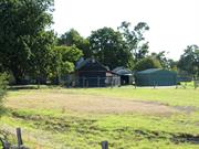
Charterhouse Rd Picton - now Wollaston
Address Now: 41-45 Flynn Street, off Charterhouse Close
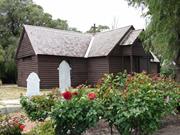
Old Picton Church, St Mark the Evangelist
St. Mark's Anglican Church & fmr. Graveyard
Bunbury
South West
Constructed from 1842
| Type | Status | Date | Documents |
|---|---|---|---|
| Heritage List | Adopted | 15 Apr 2003 | |
| State Register | Registered | 11 Mar 1997 | HCWebsite.Listing+ListingDocument, HCWebsite.Listing+ListingDocument |
| Type | Status | Date | Documents |
|---|---|---|---|
| (no listings) |
| Type | Status | Date | Grading/Management | |
|---|---|---|---|---|
| Category | ||||
| Register of the National Estate | Permanent | 21 Mar 1978 | ||
| Classified by the National Trust | Classified | 16 Dec 1976 | ||
| Municipal Inventory | Adopted | 31 Jul 1996 | ||
| Municipal Inventory | Adopted | 31 Jul 1996 | Exceptional Significance | |
| Name | Type | Year From | Year To |
|---|---|---|---|
| Henry Sillifant, gentleman whaler | Architect | - | - |
| Library Id | Title | Medium | Year Of Publication |
|---|---|---|---|
| 11701 | St Mark's Anglican Church & Graveyard, Picton | Heritage Study {Cons'n Plan} | 2015 |
| 3643 | St Mark's Church Picton : Conservation Plan. | Heritage Study {Cons'n Plan} | 1998 |
| 7299 | Bunbury images : people and places. | Book | 2004 |
Individual Building or Group
| Epoch | General | Specific |
|---|---|---|
| Present Use | RELIGIOUS | Church, Cathedral or Chapel |
| Other Use | MONUMENT\CEMETERY | Cemetery |
| Original Use | RELIGIOUS | Church, Cathedral or Chapel |
| Style |
|---|
| Victorian Carpenter Gothic |
| Type | General | Specific |
|---|---|---|
| Other | GLASS | Glass |
| Wall | TIMBER | Weatherboard |
| Roof | TIMBER | Shingle |
| Other | METAL | Wrought Iron |
| Wall | EARTH | Wattle and Daub |
| General | Specific |
|---|---|
| PEOPLE | Early settlers |
| SOCIAL & CIVIC ACTIVITIES | Religion |
This information is provided voluntarily as a public service. The information provided is made available in good faith and is derived from sources believed to be reliable and accurate. However, the information is provided solely on the basis that readers will be responsible for making their own assessment of the matters discussed herein and are advised to verify all relevant representations, statements and information.
Constructed from 1842 to 1936
St. Mark's Anglican Church, a weatherboard building with a timber shingled roof, together with its Graveyard and Moreton Bay Fig Tree , has cultural heritage significance for the following reasons: as one of the oldest extant churches in Western Australia, St Marks' Anglican Church is evidence of the Preston River settlement and of early building techniques; set within the idyllic landscape of the Preston River meadows, the place has a picturesque aesthetic quality and is a landmark within the Preston riverine precinct; the place was built by noted early resident, the Reverend John Ramsden Wollaston, Colonial Chaplain at Bunbury 1841-48 and first Archdeacon of Western Australia; the graveyard is the final resting place of many of the district's earliest settlers and provides evidence of their way of life; the large Moreton Bay Fig Tree has landmark qualities, contributes to the picturesque setting and marks the site of Reverend Wollaston's home, 'Charterhouse'.
St Mark's Anglican Church is a timber framed weatherboard clad church building constructed in 1842 in the Victorian Carpenter Gothic style of architecture. The church is cruciform in plan form. The walls are clad with weatherboards and lined with painted matchboards. The building was originally of wattle and daub construction using pit sawn timbers. The roof is clad with timber shingles (having originally been a thatched roof of rushes and sedges. There are no gutter and downpipes to the building. Internally there are steeply pitched dark oiled timber rafters with cross ties of forged steel rods. The original oil soaked calico cloth windows were replaced with pairs of cast iron casement windows with diamond shaped leadlight glass. The floor is cement, as originally designed by Wollaston. In 1936 an extensive restoration of the church was undertaken by Rev Arnold Fryer. There is a small panel showing original wattle-and-daub construction in the southern wall. This was revealed during the c 1969 restoration by Marshall Clifton. An old ship's bell hangs in the minature belfry providing a link with wrecks associated with early whaling days. The adjacent cemetery contains the graves of many of the pioneer settlers of the area, including those of William and Margaret Forrest (parents of Sir John Forrest), and the Scott family, buried beneath unusual bed-post wooden grave markers. Other grave monuments and markers include carved marble monuments and cast and wrought iron fences. The surrounding fence is now an open wooden picket fence which replaces the former split post and rail fencing. The site is surrounded by magnificent trees including peppermint and one particularly large, mature Moreton Bay Fig Tree.
St Marks Anglican Church was built on 15 acres at Location 26 in 1842 by the Reverend John Ramsden Wollaston (1790 to 1856). Wollaston was the Colonial Chaplain at Bunbury from 1841 to 1848 and was the first Archdeacon of Western Australia. The church was designed by Wollaston and built by him, his sons, agricultural servants and parishioners on his private land at “Charterhouse”. The total cost of building St Marks was £129/1/10 and the money came from donations and Wollaston’s own funds. Frederick Hymus is recorded as the thatcher of the roof and it is thought that Wollaston designed the church in wattle and daub to take advantage of the skills of his servant John Moore, a builder and a man recorded by Wollaston as ‘being clever with clay and straw’. The land the church was built on was originally owned by Lieutenant Bull, Resident Magistrate. Bull had been given the land by Governor Stirling. He then passed the land onto an American whaling captain, C F Coffin, who in turn sold it to Rev Wollaston along with the adjacent 100 acres of Location 29. To this Wollaston added the 100 acre Location 39, which was across the river. When Wollaston was posted to Albany in 1848 he sold all of his land to Henry Sillifant, except the churchyard which had been gifted to church trustees in 1843. The small timber cruciform church was opened without being consecrated in 18 September 1842. A service was held at the same time with 100 parishioners in attendance. In the early half of the twentieth century, the church began to lean and was pulled back into place with jacks. Mr R H Rose of “Moorlands” also provided funds for minor repair work. In 1936 St Marks was set to be demolished. Reverend Arnold Fryer (Rector of South Bunbury, 1932 to 1948) fought for its retention and raised funds to have it repaired. Also in 1936, the Bunbury Centenary Committee unveiled a plaque dedicated to the memory of Reverend Wollaston. In the late 1960s, noted architect Marshall Clifton helped to restore St Marks. The church was finally consecrated on 13 July 1969 and certified in the Diocesan Register at Bunbury as "St. Mark the Evangelist." The nearby cemetery contains the graves of many of the pioneer settlers in the area, including those of William and Margaret Forrest, the parents of Sir John Forrest, and the Scott family. The fig tree marks the site of Charterhouse, the Wollaston's home (See B246). This history is largely based on the Documentary Evidence in Heritage Council of Western Australia, ‘Register of Heritage Places: St Marks Anglican Church, Picton’ prepared by Ian Molyneux, 1997.
High degree of integrity (original intent clear, current use compatible, high long term sustainability). High degree of authenticity with much original fabric remaining. (These statements based on street survey only). The original split post and rail fence has been replaced by open wooden pickets.
Condition assessed as good (assessed from streetscape survey only).
| Name | Type | Year From | Year To |
|---|---|---|---|
| Clifton, Marshall [c1969 assisted with church restoration] | Architect | - | - |
| Reserve | Lot/Location | Plan/Diagram | Vol/Folio |
|---|---|---|---|
| 26&85 | D036284 85 |
This information is provided voluntarily as a public service. The information provided is made available in good faith and is derived from sources believed to be reliable and accurate. However, the information is provided solely on the basis that readers will be responsible for making their own assessment of the matters discussed herein and are advised to verify all relevant representations, statements and information.
Apart from great historic interest, architecture, character and atmosphere make it worthy of retention. In the graveyard are buried many pioneer settlers, including parents of Lord Forrest. Unusual wooden headstones.
One of the earliest buildings in Western Australia. Wooden building recently renovated, preserving a small portion of the original wall showing the laborious work of Mr Wollaston and his sons. Has rich dark ceilings now effectively lighted and is beautifully furnished. Wollaston purchased the bell from one of the earliest wrecks; it is still in use. A tablet to the memory of Archdeacon was erected by the cemetery committee
Assessment 1973 Construction April 1842 - Sep 1842 Architect/builder: Rev J R Wollaston with sons and early settlers Cost £136
This information is provided voluntarily as a public service. The information provided is made available in good faith and is derived from sources believed to be reliable and accurate. However, the information is provided solely on the basis that readers will be responsible for making their own assessment of the matters discussed herein and are advised to verify all relevant representations, statements and information.
Charterhouse St Picton - now Wollaston
in grounds of St Marks Church MI States: 41-45 Flynn St
various remnant vegetation
Bunbury
South West
Constructed from 1840
| Type | Status | Date | Documents |
|---|---|---|---|
| (no listings) |
| Type | Status | Date | Documents |
|---|---|---|---|
| (no listings) |
| Type | Status | Date | Grading/Management | |
|---|---|---|---|---|
| Category | ||||
| Municipal Inventory | Adopted | 31 Jul 1996 | Historic Site | |
| Municipal Inventory | Adopted | 04 Sep 2001 | ||
| Classified by the National Trust | Classified {Trees} | |||
00383 St Mark's Anglican Church
| Library Id | Title | Medium | Year Of Publication |
|---|---|---|---|
| 6607 | Register of significant trees as at June 1988. | Report | 1988 |
| 7299 | Bunbury images : people and places. | Book | 2004 |
Tree
| Epoch | General | Specific |
|---|---|---|
| Other Use | FARMING\PASTORAL | Cottage |
| Original Use | RESIDENTIAL | Single storey residence |
| Present Use | VACANT\UNUSED | Vacant\Unused |
| Type | General | Specific |
|---|---|---|
| Wall | TIMBER | Other Timber |
| Roof | TIMBER | Shingle |
This information is provided voluntarily as a public service. The information provided is made available in good faith and is derived from sources believed to be reliable and accurate. However, the information is provided solely on the basis that readers will be responsible for making their own assessment of the matters discussed herein and are advised to verify all relevant representations, statements and information.
Constructed from 1840
DEMOLISHED Charterhouse was the home of Reverend Wollaston and his family from 1842 to 1848 before being sold to the Richardson-Bunbury family. The house was a centre of hospitality for Anglicans and others. The place dates from the earliest days of settlement in the district.
DEMOLISHED [The Moreton Bay Fig Tree is included as part of B032]
Charterhouse was the home of Reverend Wollaston and his family from 1842 to 1846. It is understood that Charthouse was built partially re-using several rustic huts Wollaston had purchased from American whaling captain, Francis Chase Coffin. The timbers had come from the wreck of the Samuel Wright, which Coffin had purchased to provide housing for his family and crew. Wollaston called his house “Charterhouse” after the public school in London where his father was the master. Wollaston’s Picton Journal (1841-1844) provides a rare insight into the everyday life of a family who were used to a very different way of life in England. When Wollaston was appointed to Albany in 1848, he sold his land to Henry Sillifant, who rented the house to John Moore. In 1856, the property was sold to Lady Margaret Richardson-Bunbury, whose family built a prefabricated home near Charterhouse. Surveyor T C Carey gave Lady Richardson-Bunbury a seedling in the 1870s, which was planted by her servant James Cahill. Over the years, the Moreton Bay fig grew to shade the dining and drawing rooms. Lady Richardson-Bunbury’s son, William, had come to Western Australia with Australind settlers and purchased Location 28. He soon relocated to the Vasse region, but his widowed mother and sisters followed in 1856, taking up Wollaston’s former Charterhouse along with the adjacent Location 30. Alfred Richardson-Bunbury joined the family there. There are no visible remains of the original Charterhouse built by Wollaston, or of the later prefabricated building built for Lady Richardson-Bunbury. The site is marked by a plinth and the Moreton Bay Fig tree. [The tree is included as part of B032, St Mark's Church, Picton.]
DEMOLISHED
No visible remains of "Charterhouse" except for memorial plinth & plaque.
| Reserve | Lot/Location | Plan/Diagram | Vol/Folio |
|---|---|---|---|
| 85 | D036284 85 |
This information is provided voluntarily as a public service. The information provided is made available in good faith and is derived from sources believed to be reliable and accurate. However, the information is provided solely on the basis that readers will be responsible for making their own assessment of the matters discussed herein and are advised to verify all relevant representations, statements and information.
Kaeshagen St off Vittoria Rd Picton - now Wollaston
Lawrence's Wayside Inn
Morgan's Inn, Morgan's Wayside Inn, Old Picto
Bunbury
South West
Constructed from 1850
| Type | Status | Date | Documents |
|---|---|---|---|
| Heritage List | Adopted | 15 Apr 2003 | |
| State Register | Registered | 11 Mar 1997 | HCWebsite.Listing+ListingDocument, HCWebsite.Listing+ListingDocument |
| Type | Status | Date | Documents |
|---|---|---|---|
| (no listings) |
| Type | Status | Date | Grading/Management | |
|---|---|---|---|---|
| Category | ||||
| Classified by the National Trust | Classified | 05 Oct 1970 | ||
| Statewide Hotel Survey | Completed | 01 Nov 1997 | ||
| Register of the National Estate | Permanent | 21 Mar 1978 | ||
| Municipal Inventory | Adopted | 31 Jul 1996 | Exceptional Significance | |
| Library Id | Title | Medium | Year Of Publication |
|---|---|---|---|
| 8836 | Picton Inn conservation plan. | Heritage Study {Cons'n Plan} | 2007 |
| 3267 | Conservation and management plan for the Old Inn at Picton, Western Australia. | Book | 1990 |
Individual Building or Group
| Epoch | General | Specific |
|---|---|---|
| Present Use | VACANT\UNUSED | Vacant\Unused |
| Original Use | COMMERCIAL | Hotel, Tavern or Inn |
| Style |
|---|
| Vernacular |
| Type | General | Specific |
|---|---|---|
| Wall | EARTH | Wattle and Daub |
| Wall | TIMBER | Slab |
| Roof | METAL | Corrugated Iron |
| Wall | TIMBER | Weatherboard |
| General | Specific |
|---|---|
| DEMOGRAPHIC SETTLEMENT & MOBILITY | Settlements |
| OCCUPATIONS | Hospitality industry & tourism |
This information is provided voluntarily as a public service. The information provided is made available in good faith and is derived from sources believed to be reliable and accurate. However, the information is provided solely on the basis that readers will be responsible for making their own assessment of the matters discussed herein and are advised to verify all relevant representations, statements and information.
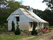
Summary: Picton Inn has cultural heritage significance for the following reasons: • The place is a picturesque building within the idyllic landscape of the Preston River meadows and a landmark within the significant Preston River riverine precinct. • The place is a rare example of an uncommon timber and earth construction technique of great historical, scientific and technological interest. • It is one of a short list of primary sites that has acquired the status of an icon of the settlement of Bunbury and its region, thus contributing to the community’s sense of place. DETAILED STATEMENT AESTHETIC VALUE The site is an expansive idyllic river meadow of the Preston River flood plain and the building stands within its setting as a major picturesque element. The sheltering form of cottage, verandah and skillioned and hipped ends, built from local natural materials is a creative achievement of some merit. The setting is within a scenic riverine precinct of meadows and regularly spaced historic homesteads of the lower Preston River and Picton Inn is one such homestead essential to perception of the existence of the precinct. HISTORIC VALUE The site selection and building are important evidence of the Preston River settlement of the 1840s initiated by and following on the failure of the Western Australian Land Company’s settlement scheme of 1841-43 at Australind, and important evidence of the subsequent growth phase of Bunbury and its region. The site has close associations with several of the historic personages who played roles in the story of the Preston River settlement and Bunbury including Archdeacon Reverend John Ramsden Wollaston, Henry Sillifant, James Thompson Lawrence, Harriett Lawrence (nee Moore), and the families of State Premiers Sir Newton Moore and Sir James Mitchell. Picton Inn is a creative and technical achievement of considerable merit and great interest as a vernacular technique imported from Britain, possibly by John Moore from Kent. SCIENTIFIC VALUE The timber framed, split slab lines, clay-daub faced construction of the house is of great technological interest apart from the historical information it conveys. SOCIAL VALUE The precinct of which the building and site are essential and inter-related parts is a very important site for its presently recognised status as a regional geographical feature and scenic pathway and for its potential to be recognised as a regional cultural heritage and recreational precinct (for all cultural environments; built and culturally modified, natural and Indigenous), all of which have characteristics that have the propensity to engender community cohesiveness and sense of place. RARITY The survival of such uncommon construction techniques is very limited and Picton Inn is a unique member of an endangered class of structures. REPRESENTATIVENESS Picton Inn is representative of a characteristic class of structures in Australia; i.e. early settlement with improvised construction from locally found material, commonly by artisans adept in the vernacular crafts of their localities of origin. CONDITION Picton Inn is in fair to poor condition. Much of the fabric has been dislodged or subject to weathering and decay, but nonetheless, it is in a stable and repairable state using the necessary degree of expertise. The current management is of a responsible curatorship and a professional conservation plan has been prepared, such that the place is currently in a holding position pending further conservation works. INTEGRITY Picton Inn retains an exceptionally high degree of integrity for such a structure, albeit unused and unlikely (because of a degree of fragility of the mud fabric and lack of modern amenities) to sustain a revival of residential occupation. There is a substantial opportunity to restore and stabilise the place. The construction technique is such as to be relatively readily restored and reconstructed, subject to a detailed technical analysis and application of advanced but simple and effective technology, to the stabilizing of the structural frame and conservation of the materials. The timeframe for such conservation works is relatively urgent but not critically so.
Picton Inn is located on a site comprising 2.01 hectares set on the northern bank of the Preston River at Picton. In close proximity, a significant homestead built by Charles Henry Lewin c.1911 is situated to the north of Picton Inn, a building not been included in this Assessment. Picton Inn is bordered to the east by Kaeshagen Road, a ‘No Through’ road that concludes at the Preston River, and to the west of the place by open fields. Picton Inn consists of an early vernacular vertical slab construction with daub infill and corrugated iron roof built in c.1850 with kitchen addition c.1880. FRAMING The structure is of roughly hewn timber uprights and horizontal members plugged with clay and rendered with lime plaster skim coating. The original section of the building is constructed of a primary framing consisting of approximately 125mm x 125mm split and adzed timber with an infill of timber slabs of irregular size in sections measuring between 100mm and 200mm in width by approximately 50mm to 75mm in thickness. The slabs have been split and roughly adzed into shape, and stand vertically with horizontal battens measuring approximately 50m x 50m fixed to the outside face of the slabs. ROOF The roof framing consists of purlins tenoned into timber ceiling trusses and with sarking boards following the original roofline of the structure. Corrugated iron sheeting is currently used as a roofing material at Picton Inn and short sheets of iron fixed with galvanized clouts remain in situ over sections of the roof. On the west end of the building and incorporating the later addition of the kitchen, a section of the earlier corrugated iron roof has been replaced with corrugated galvanised iron. This newer section has iron in single lengths from ridge to eaves fixed down with Metalfast screws.8 The eastern end and the entire southern side of the building contains corrugated iron in short sheets that has been secured the length of the building with two rows of timber ties. No guttering or downpipes are in evidence at Picton Inn. The gabled roofline has a half hip at the eastern end and the chimney extends from within the house, passing through the ridge. It is evident that the ridge exhibits a marked drop that is due to a subsidence of the chimney structure as displayed in Room A and the eastern end of the gable. Penetrometer Readings9 (1990) reflect the patterns of movement in the soil. Some evidence remains to suggest that a verandah existed on the south side of the building. The existing wall plate used to support a verandah structure is evident, while earlier photos suggest the existence of skirting board along the bottom of the wall as is consistent with the verandah on the north side of the building. A Report by John Pidgeon (1990) on the Rotational Lean of the Building discusses the instability problems associated with the lean to the south of the building. His diagram of a cross section of the central chimney outlines how the rotation of the chimney has caused the ridge and the whole roof structure to move approximately 150cm sideways. VERANDAH The verandah on the northern side of Picton Inn is covered in corrugated iron, which follows as an extension of the original broken roofline and is supported by nine verandah posts with another post situated flush against the kitchen wall. The verandah contains a simple jarrah skirting board approximately 15cm or 6” high. The verandah turns the corner on the western end and concludes in the area containing the later addition of the kitchen. The building’s original verandah posts are chamfered and remnant paint indicates that they were painted blue. However, several posts have been replaced possibly due to wood rot, and one of the replacements posts does not contain the chamfering detail. Construction methods used to secure the posts include mortice and tenon as an early means of securing timber without the use of nails. Other early construction methods include the use of the bird-mouth building application as displayed in the securing of the roofing timbers of the verandah construction. Ian Molyneux discusses the verandah at Picton Inn in his ‘Documentation of Places for Entry into the Register of Heritage Places’ when he states under the heading and in reference to Figure 5 that: Details of sawn-board-ceiled verandah and spliced verandah beam sitting on and matching the dimension of the arised posts, a common colonial era beam detail of c.1840-50. Interestingly, the Molyneux notation with Figure 3 reads: ‘East half of North Verandah. It has been suggested by a Lawrence descendant that this low verandah obliged Aborigines lofting spears to come within rifle shot during attack.’ In addition to the existing verandahs on the northern and western sides of Picton Inn, strong physical evidence suggests that a verandah would have been in place on the southern side, existing possibly from the time of the original construction, and no longer extant. The date of the demolition of the verandah is uncertain. A photo, dated pre c.1919, when enlarged appears to show an extension of the roofline of Picton Inn in the southeast corner of the building, however due to coverage of creepers the definition of the area in the photo is not clear. Later photos exhibit the addition of a wide bargeboard following the roofline, which may have coincided with the demolition of the verandah, the addition of the weatherboards and the canopy over the eastern end of the building. Existing evidence remains including a remnant wall plate, which is located under the roofline, a feature generally used to support a verandah structure. A photo clearly displaying the wall plate and the existence of skirting board along the base of the wall (similar to that seen on the north verandah) reinforces the notion of a previous verandah in this area. The construction of a verandah on the south side of Picton Inn would have been considered an essential element in the original structure as a means of protecting the fragile lathe and daub walls from weathering. Clearly a lack of protection from the elements has contributed to the ongoing disintegration of the exposed clay walls. It is possible that remnant (and undetailed) verandah posts taken from the previous verandah may have been later used on the ‘front’ or northern verandah at Picton Inn to replace damaged posts. Several posts, which have previously been spliced, display evidence that the repairs were done using recycled timber and fragments contain paint residue consistent with the blue used in other areas of the building. The original verandah floorboards have been replaced with recycled jarrah and are lifting causing an uneven surface. PARLOUR AND DINING ROOM The original dwelling consisted of a linear massing of rooms with two distinctive areas separated by a vertical slab wall and a central fireplace that serviced both areas and contained a common chimney. A doorway joining the two rooms and situated on the verandah side of the chimney has been infilled with vertical slabs and daub. Both rooms contain a doorway leading from the northern verandah, while the room to the east (Parlour) contains a doorway providing access to the south or riverside of the structure. The room on the west (Dining Room) of the central chimney contains what appears to have been a previous doorway, now containing a window set into the top section of the space with the lower portion having an infill of slab and daub. This may date from the period of an extant verandah on the south side of the building. The walls of the Dining Room and Parlour are approximately 245 cm or 8 feet high and contain remnants of Hessian lining with some areas displaying fragments of blue/green floral wallpaper with a distinctive tulip motif (Art Nouveau influences) and in some cases these spaces have been covered by newspaper sheets dated 1929. The remaining walls contain remnants of lime plaster skim coating and in several areas blue distemper features strongly on the walls, particularly in the Parlour. During the period of ownership of Picton Inn by CSBP and Farmers Limited, collar ties have been added to the Dining Room and Parlour in an effort to prevent deflections in the rafters and to stabilize the structure. As well, steel ties have been placed diagonally across the eastern end of the building inside the doorways to the under-crofts, in an effort to constrain further movement of the structure. BEDROOMS 1 & 2 At the eastern end of the Parlour is situated a mezzanine landing with loft space. The area below contains two small rooms entered from the Parlour and the dividing walls are all constructed of split slabs with daub. LOFT AREA The bottom rooms have extremely low ceiling space with the slab walls continuing into the upper areas but not extending to the roofline where a second layer of vertical slabs adds to the height of the wall and continues u to the roofline. Access to the rooms was by a ladder (no longer extant) from a ‘manhole’ in the room on the south side of Bedroom 1. KITCHEN The Kitchen has been enclosed with weatherboards over stud framing with a simple window on the west side and containing a door of jarrah planks ledged, braced and unpainted situated to the north and leading onto the verandah. The ceiling is lined with butt-jointed planks. The floor consists of wide jarrah boards on bearers resting on a clay base. A previous doorway into Dining Room has been closed off, with the use of timber slabs and in keeping with the remaining wall materials. The external brick chimney is covered in fungus due to the inadequate flashing around the chimney at roof level. FIREPLACES The Kitchen fireplace consists of an arched opening with iron lintel, simple timber fireplace surround and hearth with a rendered chimneybreast covering random/bond brickwork with two rows of headers exposed. A black cast iron pot retains some provenance to the place and remains in-situ, hanging from the fireplace on a chain. The Dining Room and Parlour contain the original brick chimneybreast, which is simple in design and constructed in a double-sided form in order to service both rooms. The fireplaces in the Parlour and Dining Room consist of soft red bricks set in generally stretcher bond (some random) with simple timber fireplace surrounds that differ slightly to each other and contain remnants of blue paint and timber hearths each made out of a single piece of jarrah. An arch shaped iron lintel supports the fireplace opening in the Parlour. Brickwork with remnants of lime-wash and a strong blue distemper remain exposed on the chimneybreast. Subsidence of the fireplace in the soft sand has caused the chimney to rotate, which in turn has caused the ridge and the whole roof structure to move sideways. This movement has brought about the sheering and crushing of the brickwork of the chimneybreast, which had been in contact with the moving roof structure. INTERNAL FABRIC The internal fabric at Picton Inn is largely original, with plaster rendering now exposing the vertical slab constructional method. Detail of the unpainted internal wall technique is exposed within the area now containing the later addition of the Kitchen. Ian Boesma in ‘Construction Methods, Materials and Detailing of Vernacular Colonial Cottages in the Southwest’ discusses how: The finish of Morgan’s Inne [Picton Inn] was unusual, being plastered to the inside and on the outside very thickly, effectively hiding its slab cladding but leaving its vertical framing exposed flush with the render. INTERNAL FINISHES Picton Inn displays some of the interior finishes as generally applied to vernacular buildings, both in order to restrict draughts and provide decorative relief for the occupants. First the walls were ‘pugged’ to fill the gaps between the vertical members and the inside walls were originally finished with a lime skim coat consisting of lime wash mixed with rock lime.16 Over this surface several kinds of finishes were used. Hessian remnants (possibly to keep out draughts) remain in evidence in several areas of the Parlour and newspaper has been applied and left exposed in poor condition on the walls. There are large remnant sections of distemper (Kalsomine) in a strong blue colour on the walls in all of the downstairs rooms. Wallpaper remnants remain in the Parlour, also blue in colour with a distinctive Art Nouveau influence and displaying tulips on the pattern. The Dining Room fireplace surround retains remnants of blue paint, while the chimneybreast is lime-washed exhibiting remnants of blue distemper and areas of exposed brickwork. In both the Dining Room and Parlour, the colour of the painted fireplace surrounds appear to match the remnant pattered wallpaper evidenced in the Parlour. DOORS The remnant doors at Picton Inn are jarrah boards of ledge and brace construction. The door on the south of the building has been reconstructed following a similar design genre. A plain glass infill sits over this doorway, replacing what would have originally been timber slabs. This currently serves the purpose of sealing the entrance while allowing light into the room. The external jarrah door to the east and opening into the under-croft (Bedroom 1) has several missing planks, which appear to be lying where they have fallen onto the floor inside the room. The two internal doorways into the under-croft from Parlour currently contain remnants of iron door hinges but no extant doors. An opening in the loft flooring, situated in the corner of Bedroom 1, appears to have been the entrance area to the loft from inside the house, however no steps or ladder remain extant. The loft or mezzanine area has a clear glass infill, which may have been fitted during the 1990s (following Pidgeon’s recommendations) as a means of securing the place and protecting it from the elements. The Kitchen door is made up with the use of narrow boards, considerably thinner than exhibited in other doors on display at Picton Inn, as would be considered consistent with a later mode of door construction. Infilling has taken place between Parlour and Dining Room next to the fireplace as well a doorway between the Kitchen and the Dining Room has been closed off. These doorways have been enclosed with slabs, butt jointed and filled with clay daub on one side. The coating has been incised with a diamond pattern to make a key for the top coating of lime wash. WINDOWS The original windows at Picton Inn may have been covered in calico in similar fashion to St Mark’s Church. At a later stage, small panes of glass were set into timber frames that operated with the use of a pivot mechanism. In early 1997, conservation work was undertaken at Picton Inn by CSBP in the interest of security, when new doors and window frames were introduced in some areas. The new doors were constructed with jarrah planks and ledged and braced as displayed in existing doors while multi-paned windows were set in jarrah frames and using the original pivot mechanism,18 in line with the existing frames. Window hardware containing a pivotal mechanism remains the general locking system for the windows. Few elements of the original door hardware remain intact. Power to the site is limited to the hardwired smoke alarms, with the power cables creating intrusive elements to the interior of the building. The source of the power is generated from a post situated in the lawn area (previously the tennis court) and approximately 6 metres east of the Kitchen. No water supply is connected to the structure.
Assessment 2008 Original Owner: James Thompson Lawrence Construction c 1850 Alterations/Additions 1880 Architect/designer not known Builder: James Lawrence, John Moore Original Use: house/Inn In 1829 Europeans first explored Bunbury and land was taken up for agricultural purposes in the district. On 21 December 1836, a township was formed at the entrance of Port Leschenault and named Bunbury. The townsite was officially proclaimed in 1841. Land was purchased in 1839/1840 by the Western Australian Company to facilitate an ‘independent land development scheme for English migrants’ , while the site of Picton Inn originally formed part of Leschenault Location 39 , which was granted to Reverend John Ramsden Wollaston subsequent to his arrival in the colony in 1841. By 1843, the Australind settlement had begun to flounder and migrants left in search of a better life moving on to such places as Perth, Pinjarra, the Vasse, Bunbury and the Preston River at Picton. In 1850 Wollaston disposed of Location 39 to Henry Sillifant, who later sold portion of the property to James Thompson Lawrence. In his journal, Wollaston records that ‘Part of the land on the other side of the river sold to Lawrence, who has built a house near the ford.’ This ‘house’ later known as Picton Inn was the residence of James Thompson Lawrence and his family. The split slab and daub building is said to have originally comprised two small bedrooms, a parlour, a dining room, and a kitchen with a lean-to and outside brick oven. The loft was added at the time of the birth of Mary Lawrence in 1852. Lawrence opened an inn at the property during the period 1850-1860, as a result of its location at Picton Ford, the main crossing point at the Preston River that accessed travelling routes to Bunbury and to other settlements in the district. A second building (later demolished) appears to have been constructed at this time to provide additional accommodation for the travellers. A wine and beer licence was granted to J.T. Lawrence of Picton in 1881 and a second licence in 1885. In the same year the Picton Inn property was sold to Alfred Lawrence and in 1895, a new liquor licence was granted to Charles Morgan at Picton Inn. The early settlement at Preston River was resited on Picton Junction following the completion of the Bunbury and Perth railway lines in 1893. This together with the erection of a new river bridge saw the loss of business at Picton Inn and its eventual replacement by the Picton Junction Hotel. The property was transferred to Charles Henry Lewin in 1904 and later to The Mount Lyell Mining and Railway Company Limited (later to be known as CSBP and Farmers Ltd and then Wesfarmers CSBP). In 2002, CSBP sold Picton Inn and River(s)dale to Colin and Anne Piacentini. In January 2008, Picton Inn is vacant. HISTORY Europeans first explored the area now known as Bunbury, for the purpose of establishing the Swan River Colony in 1829. The favourable agricultural aspect of the district resulted in the taking up of land grants in the vicinity by such persons as Governor James Stirling (1000,000 acres) and Richard Wells as agent for Colonel Latour (103,000 acres). On 21 December 1836, a township was formed at the entrance of Port Leschenault and named Bunbury in honour of Lieut. Henry St Pierre Bunbury, of the HMS Beagle. The townsite was officially proclaimed in 1841. In the period to follow, the development of the district was dominated by the Australind settlement venture. In 1839/1840, Latour’s entire estate and over half of Stirling’s grant were purchased by the Western Australian Company to facilitate an ‘independent land development scheme for English migrants’. A prospectus for the scheme was prepared and it was advertised widely in England taking the name ‘Austral-Ind’, in the hopes of attracting investors and colonists from India. The first of the Australind colonists arrived in Western Australia aboard the Parkfield in March 1841, among those were Marshall Waller Clifton and his family. Clifton had been appointed the Chief Commissioner of the Company and was to supervise the establishment of the Australind settlement. The first group was followed by the arrival of a second via the Diadem in April 1842, a third by the Trusty in December 1842 and another (and the last) again by the Trusty in May 1844.24 The colonists comprised the ‘settlers’; those land investors who had purchased 100 acre blocks in the settlement, and the ‘labourers’; many of whom were dependant upon the settlers for their living. Both groups immigrated with families in tow. The Australind settlement began to flounder and by January 1843, the numbers of people leaving Australind to find better lives were growing and by this time 76 out of a total of 441 arrivals had already left. Those who arrived as part of the venture and then left following its failure moved on to places such as Perth and Pinjarra. A number also stayed in the area, travelling south to establish themselves in the Vasse, Bunbury and on the Preston River at Picton. OWNERSHIP OF LESCHENAULT (Also Wellington) Location 39 The land on which Picton Inn is located formed part of Leschenault (also known as Wellington) Location 39, which was granted to Reverend Wollaston subsequent to his arrival in the colony in 1841. Wollaston disposed of Location 39 to Henry Sillifant, Government Resident in Bunbury, in 1850. On 18 November that same year, Sillifant sold portion of the property to James Blythe of Australind. The description of this transaction refers to Blythe’s holdings being bounded by Location 39, which had earlier been sold to James Thompson Lawrence. It is on Lawrence’s land that Picton Inn was built. Although the deed of the 1850 transaction has yet to be found, Lawrence’s ownership of the property is confirmed in Memorials dated 12 August 1863 and 27 November 1868. THE DEVELOPMENT OF THE HOUSE (Picton Inn) at Location 39 The first record of the existence of the building now known as Picton Inn appears in Reverend Wollaston’s journal dated 21 March 1851, where he notes: Part of the land [formerly owned by Wollaston and then Sillifant] on the other side of the river sold to Lawrence, who has built a house near the ford;, indicating that the place was used in the first instance as a residence for Lawrence and his family. Born in 1810, James Thompson Lawrence arrived in Western Australia aboard the Atwick on 26 April 1831. By the early 1840s, Lawrence resided in the Bunbury district and, on 8 December 1843, he married Harriet Moore with Reverend Wollaston officiating at St Mark’s Anglican church in Picton. Harriet Moore had arrived with her parents per the Diadem in April 1842 as part of the Australind settlement venture. In 1850, Lawrence took ownership of portion of Location 39 from Henry Sillifant and by March 1851 had completed a ‘house’ on the property, now referred to as Picton Inn. James and Harriet Lawrence had 12 children, three of whom were born prior to the purchase of the land at Location 39. The other children; two of whom died in infancy, are believed to have been born at Picton Inn. In his 1990 Conservation Plan for the place, John Pidgeon suggested that the loft at Picton Inn was constructed in time for the birth of Mary Lawrence in 1852.33 Despite not originally functioning as an inn, Lawrence’s c.1851 residence was built in a strategic location on a sloping site above the Picton Ford. The ford provided the main crossing point at the Preston River until it was replaced by a bridge and linked to travelling routes to Bunbury and to other settlements in the Vasse and Warren districts. It is said that during these early years Lawrence was approached by travellers using the ford, including timber workers from the local mill owned by the Forrest family, who requested meals and a place to rest. This led them to establish the inn and a second building was erected to provide additional accommodation for the travellers. These quarters were later demolished to make way for Charles Lewin’s residence, River(s)dale. Lawrence was a tanner and shoemaker by trade and subsequently added carrier and mariner to his skills, which would have stood him in good stead at Picton Ford with passing travellers providing him with valuable business. On 24 May 1881, the Government Gazette stated that a wine and beer licence had been granted to J.T. Lawrence of Picton. This was the first record of a licence yet found in relation to Picton Inn. A second wine and beer licence was awarded to Lawrence in March 1885. It was likely to be at this time that another building was added to the site. In November 1885 the property was sold to Lawrence’s son Alfred Lawrence, who was a clerk in the Perth telegraph office. James Lawrence died on 21 February 1890 and his wife, Harriet, died on 30 July 1913. Both are buried at St Marks Anglican Church in Picton. The Bicentennial Dictionary of Western Australians states that John Morgan was the licensee of Picton Inn from 1852 to 1856. However, John Pidgeon’s 1990 research shows that during this time Morgan’s licence was held at Bunbury, not Picton.43 Further to this, neither John Morgan, nor anyone by the name of Morgan, was recorded as the owner on the Memorials and Certificates of Title for Picton Inn. It was in the 1890s that State Government funded development of the Bunbury area to facilitate growth of the region resulted in new infrastructure such as the railway and better bridges.45 This impacted on the business of Picton Inn as the new communication routes saw the centralisation of business to Picton Junction; so named because of its location at the junction of the Bunbury and Perth railway lines in 1893. A new hotel was erected at the Junction and from 1900 the names of people granted liquor licences in the town are those associated with the Picton Junction Hotel (later Picton Tavern). On 19 February 1904, the entire property was transferred into the ownership of Charles Henry Lewin of Bunbury. Lewin was a butcher by trade and, although his central business was situated in Bunbury proper, he leased and purchased a number of properties in close proximity to the town on which he could graze his stock. It was for this purpose that Picton Inn as well as several lots adjoining this land; one of which later became the site for Lewin’s new family residence. Charles Lewin married Blanche Howard in 1903. The young Lewin family lived at Picton Inn and Rosalind Blanche Lewin stated that she was born at the place on 4 July 1907. The existing buildings on the property were not suited for the growing family and soon a new home was built for them immediately to the [north] east of Picton Inn. River(s)dale was the large residence constructed for the Lewin’s in c.1911 and is believed to be the work of prominent southwest architect Eustace Cohen. Charles Lewin died on 10 October 1925 and, on 22 March 1926, probate of his will was granted to his widow Blanche Lewin of Bunbury and storekeeper John Monkhouse of Bunbury. On 19 August 1926, The Mount Lyell Mining and Railway Company Limited were registered as the proprietors of Picton Inn. The Mount Lyell Mining & Railway Company Limited was established at Rocky Bay in North Fremantle in 1909.52 It was during this period that the Western Australian wheat industry was subject of much development, This was partly due to the introduction of fertilizers and trace elements, which opened more land for production, increased wheat yields and in turn led to the growth of a superphosphate industry. Another company founded to take advantage of agricultural growth was the Cumming Smith and Co. Pty Ltd in Bassendean also in 1909. In 1927 both companies were reorganised to form the Cumming Smith and Mount Lyell Farmers Fertilisers Ltd. Concurrent to this and into the 1930s, the firm developed a partnership with Westralian Farmers Ltd that saw farmers from around the state acquire shares in Cumming Smith and Mount Lyell Farmers Fertilisers Ltd as a means of ensuring that their interests and needs were met. The amalgamation of the businesses is reflected on the Certificate of Title for the place. On 17 April 1928, Mount Lyell Farmers Fertilisers Limited was listed as the owners, followed by Cumming Smith and Mount Lyell Farmers Fertilizers Limited in November 1929. It became known as CSBP and Farmers Limited and more recently as Wesfarmers CSBP. (Note: For ease of reference, the name CSBP will be used for the remainder of the document.) Charles Lewin’s River(s)dale became the residence of the manager of the Bunbury works and Picton Inn formed part of the grounds of the property. From as early as the 1930s/1940s there was a commitment by the various managers of the Bunbury operations of CSBP to maintain Picton Inn to a point to which the building was stabilised and deterioration stopped. Although vacant from this time on, it was retained for historical interest and made available by appointment for public viewing. In 1964, the Preston River flooded and the waters reportedly came within a short distance from the western side of Picton Inn. It appears possible that such flooding and ongoing damp and drainage problems may be the cause of the subsidence of the building and the weathering of the western section. Flooding caused the bridge to collapse and a new bridge was constructed soon after however situated several hundred metres to the south/east of the original fording bridge. On 5 October 1970 Picton Inn was classified by the National Trust of Australia (WA). Picton Inn was entered into the Federal Government’s Register of the National Estate on 21 March 1978. In the early 1980s, the cultural heritage significance of Picton Inn was again recognised when it was protected through its inclusion in the City of Bunbury Town Planning Scheme. In 1989, a dialogue was entered into between the National Trust (WA) and the Manager of CSBP at Picton regarding the future of Picton Inn. It was as a result of this that architect John Pidgeon was appointed to prepare a conservation management plan for the building. In this, Pidgeon recommended that the building be ‘preserved’ as opposed to ‘restored’ so that building layers then revealed via its dilapidated appearance would remain visible to visitors. Picton Inn was adopted as part of the City of Bunbury’s first Municipal Inventory in July 1996 and has remained included in the Inventory in subsequent reviews. Under this programme, it is afforded the highest level of protection. On 5 November 1996, Picton Inn was entered into the Heritage Council of Western Australia State Register of Heritage Places with interim status and on 11 March 1997 was permanently entered into the Heritage Council of Western Australia State Register of Heritage Places. In early 1997, conservation work was undertaken at Picton Inn by CSBP. The company: ….restored the outside of the building by replacing the mud render with matching material dug from site and lime wash mixed from rock lime. The verandah flooring was replaced with recycled Jarrah and steel ties introduced to stop further rotation of the structure. New doors and window frames were introduced, using the original pivot mechanism, in the interest of security. In 2002, CSBP sold Picton Inn and River(s)dale and on 14 September 2002, Colin and Anne Piacentini were registered as proprietors of Picton Inn. Since this time, the owners have undertaken extensive works to the property, which have incorporated restoration and additions to River(s)dale, landscaping to the grounds including gardens in close proximity to Picton Inn, the installation of drainage at ground level to the inn, and general repairs and maintenance such as the installation of a hot wired smoke alarm. In 2006 a Conservation Plan was undertaken by Kent Lyon architect, to support a HCWA grant for the owners, and a major conservation works programme aimed in part in stabilizing Picton Inn. Civil and Structural Engineers, Bunbury prepared a Structural Assessment for Picton Inn in 2006, and following on from this report and including the policy recommendations from the Conservation Plan for Picton Inn 2006, work began in stabilizing the building in 2007 and continues in 2008.
This assessment includes the place known as Picton Inn, a vernacular construction of vertical slabs with daub and corrugated iron roof, dating from c.1850 and extended in c.1880. Included also is the area immediately surrounding Picton Inn and consisting of a site sloping marginally from the northern end of the block with the gradient progressing gradually down to the post and wire fence on the south side of the building and close to the banks of the Preston River. Situated to the north of Picton Inn is River(s)dale c.1911, a substantial homestead currently occupied by the owners of both of these buildings. Picton Inn is surrounded on the west by open paddocks containing two large water tanks and bordered on the east side by Kaeshagen Road, a ‘No Through’ road that leads from Vittoria Road and concludes at the Preston River.
This information is provided voluntarily as a public service. The information provided is made available in good faith and is derived from sources believed to be reliable and accurate. However, the information is provided solely on the basis that readers will be responsible for making their own assessment of the matters discussed herein and are advised to verify all relevant representations, statements and information.
Constructed from 1850
Old Picton Inn, a small vernacular "wattle and daub" dwelling, has cultural heritage significance for the following reasons: the place is a most picturesque rustic building within the idyllic landscape of the Preston River meadows and being a landmark within the significant Preston riverine precinct; the place is evidence of the Preston River settlement, as a marker of the historic Preston River ford and the former 'Blackwood Road' route and crossing, and association with historic personages in the settlement; the place is a rare extant example of an uncommon timber and earth construction technique of great historical, scientific and technological interest.
Picton Inn is a simple single storey vernacular building, set on the northern bank of the Preston River. The site is open and largely covered with lawns with a number of trees. To the north and west of the site are open fields. To the south of the site the lawn gives way to uncultivated river-flat land running down to the tree-lined banks of the Preston River. The architectural style is a vernacular one of improvisation utilising natural materials of clay and split and sawn timber, taken from the immediate locality. The walls are constructed by standing posts between timber ground and top plates, with mid-rails attached to the posts. This framing is lined internally with slabs of timber housed onto the plates. Externally, battens have been nailed onto the slabs to form a key for a clay and straw mix which has then been plastered onto the slabs and smoothed flush with the outer face of the posts, forming fully filled panels between the posts. Paint coatings are presumed to have replaced an earlier sacrificial protective coating of lime wash. Internally, the slabs and joints between plastered flush with another layer of clay daub which has been variously whitewashed, lined with hessian and papered. Previous description notes: Later, parts of the building was clad with weatherboards and the roof replaced with corrugated iron held on with horizontal timber battens to secure in place. The pavilion consists of detached kitchen, with external brick oven, dining room, parlour and two bedrooms with one loft bedroom commonly referred to as the 'bridal suite' accessible by a ladder through a trapdoor or by an outside stairway.
Picton Inn was built c. 1850 by James Thompson Lawrence. Lawrence was a shoemaker by trade and had arrived in Western Australia in 1830. The land was originally part of the Location 26, the large land grant awarded to Governor Stirling in the early 1830s. It was later part of Reverend Wollaston’s farm (1842 to 1850). It has been recorded that Lawrence built a small slab hut on a point of land near the Preston River ford. It is thought that his father-in-law, John Moore, helped him build the inn as he was a builder who, according to Reverend Wollaston, was ‘clever with clay and straw'. In 1881, Lawrence applied for and was granted a liquor licence. He called his establishment Lawrence’s Wayside Inn and he catered for travellers crossing the ford as they travelled through the district. Many of his customers were timber jinkers going between Wellington Mill and the port at Bunbury. When Lawrence died in 1890, the licence was awarded to John Moore, who operated the Inn until c. 1900. The Inn later reverted to a private residence. The Lewin family lived there while their house at Riversdale was being built and their daughter, Rosalind was born there. Rosalind was later well known in the district for her work as an Infant Health Sister. The old Picton Inn was bought by CSBP and Farmers Ltd in the 1930s. The manager resided at Riversdale and the company took over the responsibility of the maintenance of the Inn to prevent it from falling into disrepair. In 1996 the Inn was unoccupied. This history is based on the Documentary Evidence in Heritage Council of Western Australia, ‘Register of Heritage Places: Picton Inn’, prepared by Ian Molyneux, 1997
The building remains largely in its original form.
Exterior: Fair to good. CSBP has maintained the Inn for decades.
| Reserve | Lot/Location | Plan/Diagram | Vol/Folio |
|---|---|---|---|
| 200 | P056668 200 |
This information is provided voluntarily as a public service. The information provided is made available in good faith and is derived from sources believed to be reliable and accurate. However, the information is provided solely on the basis that readers will be responsible for making their own assessment of the matters discussed herein and are advised to verify all relevant representations, statements and information.
Lot 91 South Western Hwy Picton - now Wollaston
fmr Picton Road (On the Preston River near the intersection with Vittoria Road)
Olive Trees & Mill Farm
The Old Place
Bunbury
South West
Constructed from 1849 to 1960
| Type | Status | Date | Documents |
|---|---|---|---|
| Heritage List | Adopted | 15 Apr 2003 | |
| State Register | Registered | 29 Sep 1998 | HCWebsite.Listing+ListingDocument, HCWebsite.Listing+ListingDocument |
| Type | Status | Date | Documents |
|---|---|---|---|
| (no listings) |
| Type | Status | Date | Grading/Management | |
|---|---|---|---|---|
| Category | ||||
| Municipal Inventory | Adopted | 31 Jul 1996 | Exceptional Significance | |
| Classified by the National Trust | Recorded | 05 Oct 1970 | ||
| Register of the National Estate | Indicative Place | |||
| Name | Type | Year From | Year To |
|---|---|---|---|
| Eales Cohen and Bennett | Architect | - | - |
Individual Building or Group
| Epoch | General | Specific |
|---|---|---|
| Present Use | FARMING\PASTORAL | Homestead |
| Original Use | FARMING\PASTORAL | Homestead |
| Original Use | RESIDENTIAL | Single storey residence |
| Style |
|---|
| Late 20th-Century Perth Regional |
| Federation Arts and Crafts |
| Victorian Georgian |
| Type | General | Specific |
|---|---|---|
| Wall | BRICK | Rendered Brick |
| Roof | TILE | Terracotta Tile |
| Wall | TIMBER | Other Timber |
| Wall | BRICK | Handmade Brick |
| General | Specific |
|---|---|
| PEOPLE | Early settlers |
| PEOPLE | Famous & infamous people |
| DEMOGRAPHIC SETTLEMENT & MOBILITY | Workers {incl. Aboriginal, convict} |
This information is provided voluntarily as a public service. The information provided is made available in good faith and is derived from sources believed to be reliable and accurate. However, the information is provided solely on the basis that readers will be responsible for making their own assessment of the matters discussed herein and are advised to verify all relevant representations, statements and information.
Constructed from 1849 to 1930
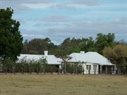
Forrest Homestead and Olive Trees, has cultural heritage significance because: the place has been the home of members of the Forrest family since the 1840s; the Forrest family were of exceptional importance in the development of Bunbury and Western Australia, and also of Australia; the place is a well preserved example of a rural homestead which has been adapted to suit the needs of subsequent generations; the early fabric and particularly the 1930s addition, which comprise most of the house, are fine examples of architecture from their period. The 1930s addition is a fine example of the work of promient architects Eales and Cohen; the place includes an important collection of furniture and memorabilia relating to its owners and occupiers and important events with which they were associated; the grouping of the house and large, mature olive trees planted by William Forrest to represent each of his nine sons form a landmark that contribute to the aesthetic qualities of the landscape; and, the place includes the site of the Leschenault Mill Race which was testimony to the engineering skills of early settler, William Forrest, who constructed a mill race capable of powering what was eventually a large two storey mill. The mill was important to the local economy and provided flour for the local market.
Forrest Homestead is a former farmhouse with additions in four distinct stages since first built c. 1849 by William Forrest. The house is a single-storey building constructed of brick walls, terracotta tile roof and timber floors. Verandahs to the north, west and south elevations and large bay windows to the north dominate the building form. Although built up in stages, an orange terracotta tile roof (Bristile and Wunderlich ‘Roman’ pattern) installed in the 1960s unifies the house. Walls to the older section of the building appear to be laid on brick footings. Bricks to the pre 1930 building were made from clay dug on site. The clay pits are extant. There are three distinct building styles discernible in the exterior of the building which match stages in building. The older part of the building, as defined by the 1930 additions, could be best described as ‘Colonial Vernacular’ as identified in Hocking (1995) which is a Western Australian extension of Apperly (1989). The extensions designed by Eales Cohen and Bennett are in an arts and crafts style defined by Hocking as ‘Inter War Arts and Crafts’. This extension and extensive remodelling of the exterior and interior of the house betrays Eustace Cohen’s intense interest in arts and crafts architecture. Inspection of external walls of the pre 1930 building reveals that there were probably at least one addition to the original 1849 building as both Flemish and Colonial bond brickwork can be discerned. The west verandah was deepened in 1930, but the west wall left intact including two fine cast iron casements in Gothic trace patterning. Forrest Homestead was again altered in the 1960s with a new wing containing a large kitchen, laundry and garage in painted stretcher bond brickwork and aluminium windows. At this time the entire building was re-roofed in Brisbane and Wunderlich Roman pattern clay tiles. Displaying clean brickwork, orange roof tiles, exposed timber eaves, verandahs and regard for climate the style could be described as Late Twentieth Century Perth Regional.
Forrest Homestead was built c 1849 for the Forrest family, who were closely linked with the development of Bunbury. William Forrest, an engineer, was born on 19 February 1819 at Bervie, near Stonehaven in Kincardinshine, Scotland. He married Margaret Guthrie Hill in Glasgow in June 1840 and in September 1842 they answered an advertisement in the newspaper for a husband and wife to move to Western Australia as servants for Dr Ferguson. Ferguson, a medical doctor, was emigrating to Australind as an investor/settler with the Western Australian Company. The Forrests left from Gravesend on 2 August 1842 aboard the Trusty. They arrived in Bunbury on 9 December 1842. Although the Australian scheme was a failure, Ferguson struggled to make a success while on the other hand Forrest proved that he was capable of almost anything. Forrest built many of the first bridges in the district. The Forrests were released from their employment with the Fergusons in 1846, when William Forrest was appointed Colonial Medical Officer. William returned to his former trade of an engineer and millwright. To this end he leased land on a promontory in the Leschenault estuary and constructed a wind powered mill and a small timber home. By this time, the Forrests had three sons: William (born on the voyage out to Western Australia, 1842); James (born at Australind, 1845), and future premier John (born at Mill Point on 22 August 1847). After the milling enterprise failed due to flooding and intermittent wind, in 1849 Forrest purchased 100 acres on the banks of the Preston River at Picton from James Hertman for £50. The same year their fifth son, Alexander, was born. William built the homestead using clay from a seam on his property near the Ferguson River. He used hand fired bricks, crushed limestone and pit-sawn jarrah to build the house which had a low, split shingle roof. He also built another mill by constructing a dam on the Ferguson River and a mill race to power the mill. By March 1851, the Leschenault Water Mill was in operation, producing a ton of flour a day and was so successful that Forrest was soon able to purchase 400 acres of surrounding land. Despite the limited output of early flour mills such as Forrest’s, it played a vital role in the colonial colony. Due to the shortage of cash, much of the internal trade was carried out by barter, flour being one of the commonest commodities used. This gave the mill owners a powerful role in the district, and the ownership of mills was, not surprisingly, closely associated with the colonial pastoral and mercantile elite. Forrest’s mill closed in September 1867 when the building was destroyed by fire caused by a lightning strike. Damage was estimated at £3,000. William and Margaret had five sons while they were at Picton; David (January 1852), Robert (September 1854), Mathew (January 1857), George (November 1858) and Augustus (November 1861) who drowned as a toddler in the mill race. William is said to have planted nine olive trees for each of his sons on the west side of the house and they still stand today. Of the sons, Alexander became a leading explorer, financier and pastoralist, William and James were successful farmers in the south-west, George stayed on at the ‘Old Place’ and taking over from his father when he died and Robert continued his father's engineering and flour-milling business in Bunbury. John became premier of Western Australia in 1890 and was the first federal treasurer in 1901. Margaret and William are buried at St Mark’s Anglican Church at Wollaston [Picton]. Between 1849 and 1960, three major additions were completed to the Forrest’s Homestead. The first was probably completed in the late 1800s and Eales, Cohen and Bennett designed additions in the Arts and Crafts style in the 1930s. More additions were completed in the 1960s. Forrest Homestead has remained in the Forrest family for generations. In 2011, it it still owned by William and Margaret's descendants. This history is largely based on the documentary evidence in Heritage Council of Western Australia, 'Register Entry: Forrest Homestead’, prepared by Donna Houston and John Stephens, 1998
No apparent loss of architectural integrity with the 1930s unification of buildings under one roof.
Brick and tile homestead, mill farm and olive trees all appear in good condition.
| Name | Type | Year From | Year To |
|---|---|---|---|
| Eales and Cohen | Architect | - | - |
| Reserve | Lot/Location | Plan/Diagram | Vol/Folio |
|---|---|---|---|
| 91 | P026522 91 |
This information is provided voluntarily as a public service. The information provided is made available in good faith and is derived from sources believed to be reliable and accurate. However, the information is provided solely on the basis that readers will be responsible for making their own assessment of the matters discussed herein and are advised to verify all relevant representations, statements and information.
9 Shenton St Rathmines, Bunbury
SE Cnr Austral Pde
Leston
Bunbury
South West
Constructed from 1924
| Type | Status | Date | Documents |
|---|---|---|---|
| Heritage List | Adopted | 15 Apr 2003 | |
| State Register | Registered | 27 Feb 1996 | HCWebsite.Listing+ListingDocument, HCWebsite.Listing+ListingDocument |
| Type | Status | Date | Documents |
|---|---|---|---|
| (no listings) |
| Type | Status | Date | Grading/Management | |
|---|---|---|---|---|
| Category | ||||
| Aboriginal Heritage Sites Register | Interim | |||
| Register of the National Estate | UNKNOWN | |||
| Classified by the National Trust | Classified | 12 May 1997 | ||
| Municipal Inventory | Adopted | 31 Jul 1996 | Exceptional Significance | |
Individual Building or Group
| Epoch | General | Specific |
|---|---|---|
| Present Use | RESIDENTIAL | Single storey residence |
| Original Use | RESIDENTIAL | Single storey residence |
| Style |
|---|
| Vernacular |
| Type | General | Specific |
|---|---|---|
| Roof | METAL | Corrugated Iron |
| Wall | TIMBER | Weatherboard |
| General | Specific |
|---|---|
| PEOPLE | Famous & infamous people |
| DEMOGRAPHIC SETTLEMENT & MOBILITY | Land allocation & subdivision |
| PEOPLE | Early settlers |
This information is provided voluntarily as a public service. The information provided is made available in good faith and is derived from sources believed to be reliable and accurate. However, the information is provided solely on the basis that readers will be responsible for making their own assessment of the matters discussed herein and are advised to verify all relevant representations, statements and information.
Constructed from 1924
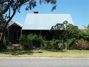
Leston, a weatherboard and iron house has cultural heritage significance for the following reasons: the place has landmark qualities and contributes significantly to the streetscape and the community's sense of place. the place is a component of the local picturesque townscape, which includes St Patrick's (fmr) Anglican Church and churchyard; the place exhibits historic values in the development of the locality of Rathmines and land ownership and subdivision patterns in the Bunbury region; the place exhibits rarity for its unchanged materials and form; the place has social values through its long continuity of association with the local community.
Leston, 9 Shenton Street is a single storey timber and iron house constructed in the Inter-War period. The walls are timber framed and clad with untreated timber weatherboards. The roof is pitched and half gabled and clad with corrugated iron. The verandah is under a continuous corrugated iron roof supported by timber posts and continues around the house under the gable end. The front façade has a central front door with modern security screen fitted flanked on one side by timber framed casement windows. There is an addition to one side clad with fibre cement sheeting weatherboards with a small portico and another entrance door. Some weatherboards at the side have also been replaced with fibre cement sheeting. There is a face brick chimney evident. The house is situated at street level. There is a timber post and wire fence with wire gate to the front boundary line. Note: In 2008 significant additions to the house were approved and there is a new front fence to the property.
Leston, 9 Shenton Street (also known as the Clifton Residence), Rathmines, was built in 1924 for Isabella Clifton and her children. After Isabella's husband, Edward Clifton died of a heart attack without leaving any estate to his widow, a relative helped Mrs Clifton acquire a lot in Rathmines and build a house. Prior to Edward’s death, the family had lived in a cottage on the “Rosamel” property at the head of Leschenault Inlet. The Clifton’s called the house “Leston” and they moved in on 8 October 1924. Ethel Clifton, one of the children, remembered how her family moved their household goods in a wagon. It had rained that day, so their bedding was soaked and they had to spend the first night at the next door neighbours. Ethel inherited the house and lived there until her death in 1997. While Ethel lived at “Leston” she did not fundamentally alter the house or the yard, and furnished the interior of the house contemporaneous to the period in which it was built. The trees and garden are therefore an integral part of the place. The house was one of the first houses built in Rathmines, which was subdivided by Reverend Withers in the late 1890s. The suburb was names for Withers’ home town in Ireland. This history is based on the Documentary Evidence in Heritage Council of Western Australia, 'Register Entry: Clifton Residence', (author not named), 1996. In 2008 significant additions to the house were approved and there is a new front fence to the property.
High degree of integrity (original intent clear, current use compatible, high long term sustainability). High degree of authenticity with much original fabric remaining. (These statements based on street survey only). The interiors and exterior are largely as built and unpainted. Yard elements are especially of note, including the washing "props"; post and wire fence and woodheap all of which are rarely found in Bunbury today.
Condition assessed as good (assessed from streetscape survey only).
| Reserve | Lot/Location | Plan/Diagram | Vol/Folio |
|---|---|---|---|
| 42 | P000881 42 |
This information is provided voluntarily as a public service. The information provided is made available in good faith and is derived from sources believed to be reliable and accurate. However, the information is provided solely on the basis that readers will be responsible for making their own assessment of the matters discussed herein and are advised to verify all relevant representations, statements and information.
Lot 963 Estuary Dr Vittoria
Heritage roses
Trees: Olives, Camphor laurel, Oaks
Bunbury
South West
Constructed from 1846 to 1874
| Type | Status | Date | Documents |
|---|---|---|---|
| Heritage List | Adopted | 15 Apr 2003 | |
| State Register | Registered | 20 Dec 2011 | HCWebsite.Listing+ListingDocument, HCWebsite.Listing+ListingDocument |
| Type | Status | Date | Documents |
|---|---|---|---|
| (no listings) |
| Type | Status | Date | Grading/Management | |
|---|---|---|---|---|
| Category | ||||
| Municipal Inventory | Adopted | 31 Jul 1996 | Exceptional Significance | |
| Classified by the National Trust | Classified | 06 Apr 1970 | ||
| Register of the National Estate | Permanent | 21 Mar 1978 | ||
| Library Id | Title | Medium | Year Of Publication |
|---|---|---|---|
| 3439 | The Restoration and Reconstruction of Leschenault Homestead for the Bunbury Port Authority | Heritage Study {Other} | 1998 |
| 6360 | 2020 vision : Port strategy. | Report | 2000 |
| 1570 | Leschenault Homestead Conservation Plan 1996- Part One | Heritage Study {Cons'n Plan} | 1996 |
| 4643 | Bunbury Port Authority : Bunbury Port development investigation. | Report | 1999 |
| 6571 | Leschenault Homestead, Bunbury : physical inspection report. | Heritage Study {Other} | 2003 |
| 10019 | Leschenault Homestead Cottages archival and structural report. | Archival Record | 2012 |
| 6572 | Leschenault Homestead, Bunbury : physical inspection report, structural report, landscape assessment report. | Heritage Study {Other} | 2003 |
| 6570 | Leschenault Homestead, Bunbury : physical inspection report, structural report, landscape assessment report. Summary. | Heritage Study {Other} | 2003 |
| 9015 | Report of a conservation project: The restoration and reconstruction of the homestead buildings. (1996 - 1997 Campaign) at Leschenault Homestead, Bunbury, Western Australia for the Bunbury Port Authority. | Conservation works report | 1997 |
| 9073 | Leschenault Homestead planning committee. Final report. | Heritage Study {Other} | 2007 |
| 8549 | Conservation management plan - Stage 1 forthe 'Leschenault Homestead' forthe Bunbury Port Authority 3rd August 2001. | Heritage Study {Cons'n Plan} | 2001 |
| 6631 | Proposal for the relocation and conservation of Leschenault Homestead. | Report | 2003 |
| 4646 | Industry 2030 : greater Bunbury industrial land and port access planning : final. | Report | 2000 |
| 6532 | Western Australian endangered places 2003. | Kit | 2003 |
| 1611 | Leschenault Homestead Conservation Plan - Part Two | Heritage Study {Cons'n Plan} | 1996 |
| 7299 | Bunbury images : people and places. | Book | 2004 |
| 6573 | Leschenault Homestead, Bunbury : landscape assessment. | Heritage Study {Other} | 2003 |
Individual Building or Group
| Epoch | General | Specific |
|---|---|---|
| Other Use | FARMING\PASTORAL | Shed or Barn |
| Original Use | GOVERNMENTAL | Office or Administration Bldg |
| Original Use | FARMING\PASTORAL | Homestead |
| Present Use | RESIDENTIAL | Single storey residence |
| Style |
|---|
| Old Colonial Georgian |
| Type | General | Specific |
|---|---|---|
| Roof | METAL | Zincalume |
| Wall | EARTH | Wattle and Daub |
| Other | BRICK | Handmade Brick |
| Other | GLASS | Glass |
| Wall | TIMBER | Weatherboard |
| General | Specific |
|---|---|
| OCCUPATIONS | Grazing, pastoralism & dairying |
| SOCIAL & CIVIC ACTIVITIES | Government & politics |
| DEMOGRAPHIC SETTLEMENT & MOBILITY | Settlements |
| PEOPLE | Famous & infamous people |
This information is provided voluntarily as a public service. The information provided is made available in good faith and is derived from sources believed to be reliable and accurate. However, the information is provided solely on the basis that readers will be responsible for making their own assessment of the matters discussed herein and are advised to verify all relevant representations, statements and information.
Constructed from 1840, Constructed from 1854
Leschenault Homestead has cultural heritage significance for the following reasons: the place is a rare surviving group of very early colonial buildings and structures from the period of early European settlement in Western Australia; the place has high historic value as an example of early settlement and the history and development of the South West and its association with notable people such as William Pearce Clifton; the place has scientific value demonstrating early building techniques no longer practiced; the place has aesthetic value as a group of early colonial buildings in a picturesque setting.
Leschenault Homestead comprises the original wattle and daub weatherboard clad cottage (c.1846) and two further cottages, the main single-storey building (c.1854-70) of weatherboard clad adobe and shingles, the original round stone water tank, and the grounds and setting. The original cottage was built c 1846 by William Pearce Clifton of wattle-and-daub covered with weatherboards. This cottage with brick chimney, was built of timber studs with clay plastered on to an infill of wattles, the exterior being clad with pit sawn weatherboards, the interior papered or white-washed. The main single-storey weatherboard building was erected c 1854-70 with encircling verandahs and a low protective roof. The walls are of adobe, clad with weatherboard, and the original shingles are covered with corrugated iron (to be checked). It has distinct scalloped barge boards typical of its periods Nearby is the original round stone water tank which is still in use. The complex, which is surrounded by attractive grounds, is a fine example of early vernacular building.
Leschenault Homestead comprises a collection of buildings built between c. 1840 and c 1870 for William Pearce Clifton. The buildings include the ‘Eastern Cottage’ (a prefabricated cottage), Middle Cottage, the Kitchen Cottage, Leschenault Homestead and a number of outbuildings. Known as Pearce, William Pearce Clifton, had been born in Putney, London, in January 1816. He was one of fifteen children, most of whom emigrated to Western Australia in 1841 as part of the Australind Settlement. Their father, Marshall Waller Clifton, was one of the leaders of the ill fated scheme. Pearce Clifton was a staunch civic and church leader, who was also involved in farming and the timber industry. For some time, he held the position of Superintendent of Convicts and Inspector of Works for the district. On 31 January 1846, Clifton took up a land grant for the purpose of establishing a farm and decided to transport two of the buildings from the Australind settlement to his new property. These were prefabricated buildings that had been brought out from England by some of the original Australind settlers. On 24 February, Daniel McGregor, the stepson of John Scott (one of the first settlers in the Bunbury district), dismantled the two cottages, loaded them on a punt and floated them down the estuary from Australind to the Leschenault block. McGregory re-erected the cottages the next day. One was known as ‘Elinor’s Cottage’ (later ‘Eastern Cottage’) and the Kitchen Cottage. ‘Leshenault Homestead’, the main building, was constructed in stages between 1844 and 1874. The first stage was built from pit sawn timber with clay, wattle, weatherboards and newspaper covered with whitewash. Additions in 1854 and 1874 included a detached verandah, bay windows and beautiful joinery. Leschenault Homestead became one of the social centres of the Bunbury district. It was often used for entertainments and as the base of the local hunt club. The gardens consisted of oaks, willows and olives. It is reported that Pearce planted cuttings of willows taken from Napoleon’s grave on St Helena’s. From 1851 to 1858, Clifton was a member of the Legislative Council. At this time, the Legislative Council comprised the Governor, five official nominee members (from the government service) and four non-official nominee members, who were elected for life. Clifton was a non-official nominee member and resigned from the position in 1858. Clifton was appointed Resident Magistrate for the Wellington District in 1871. Leschenault Homestead became the de facto ‘Residency” for Bunbury from the time of Clifton’s appointment until his death in 1885. John Forster Johnston, a successful dairy farmer, was appointed manager of the property in 1885. Johnston’s sons, Eric and Harold, (who traded as Johnston Brothers) bought the property at a later date. Harold and his family lived in Leschenault Cottage on Old Coast Road while Eric resided in the main home. In 1968, Eric sold Leschenault Homestead to the Bunbury Port Authority. A condition of the sale was that Eric and his wife ‘Precious’ be granted life tenancy in Leschenault Homestead. In 1986 a Bunbury Port Authority employee was installed as resident caretaker of Leschenault Homestead. At the time, the buildings were reported to be in poor condition. The property is closely associated with the early settlement of Bunbury and is significant as one of a small number of such structures which remain from the beginning of colonial settlement in this area today.
The buildings remain largely in original form and the integrity and authenticity are high. Some outbuildings remain though the barn and dairy have been demolished. The area includes grounds surrounding the homestead which is articulated on the BPA Report Site Plan.
The cottages show alarming signs of deterioration from weather and white ants; and suffers from rising and falling damp despite some remedial work having been carried out on and around the buildings. The condition of the buildings generally ranges from good to very poor. Threatened by encroaching Inner Harbour development has raised the possibility of re-locating the buildings to another site. Some conservation works have been carried out to the main building. Further investigation is required to determine the current condition of the buildings.
| Reserve | Lot/Location | Plan/Diagram | Vol/Folio |
|---|---|---|---|
| 963 | VCROWNLAND |
This information is provided voluntarily as a public service. The information provided is made available in good faith and is derived from sources believed to be reliable and accurate. However, the information is provided solely on the basis that readers will be responsible for making their own assessment of the matters discussed herein and are advised to verify all relevant representations, statements and information.