Local Government
Busselton
Region
South West
21 Kaloorup Rd Vasse
Off Bussell Hwy Approx. 2.5kms S/W of junction with Yalingup Rd.
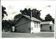
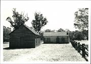
Old Vasse School
Busselton
South West
Constructed from 1901
| Type | Status | Date | Documents |
|---|---|---|---|
| State Register | Registered | 21 Sep 2001 | HCWebsite.Listing+ListingDocument, HCWebsite.Listing+ListingDocument |
| Type | Status | Date | Documents |
|---|---|---|---|
| (no listings) |
| Type | Status | Date | Grading/Management | |
|---|---|---|---|---|
| Category | ||||
| Register of the National Estate | Nominated | 04 Nov 1981 | ||
| Register of the National Estate | Indicative Place | |||
| Classified by the National Trust | Classified | 10 Jun 1980 | ||
| Municipal Inventory | Adopted | 20 Jun 1996 | Category 1 | |
The place is in very good condition.
| Name | Type | Year From | Year To |
|---|---|---|---|
| Public Works Department | Architect | 1901 | - |
| Library Id | Title | Medium | Year Of Publication |
|---|---|---|---|
| 3066 | Vasse Primary School: Conservation Plan | Heritage Study {Cons'n Plan} | 1998 |
Individual Building or Group
| Epoch | General | Specific |
|---|---|---|
| Present Use | EDUCATIONAL | Library |
| Original Use | EDUCATIONAL | Primary School |
| Style |
|---|
| Vernacular |
| Type | General | Specific |
|---|---|---|
| Wall | TIMBER | Weatherboard |
| Roof | METAL | Corrugated Iron |
| General | Specific |
|---|---|
| SOCIAL & CIVIC ACTIVITIES | Institutions |
| PEOPLE | Early settlers |
| SOCIAL & CIVIC ACTIVITIES | Community services & utilities |
| SOCIAL & CIVIC ACTIVITIES | Education & science |
This information is provided voluntarily as a public service. The information provided is made available in good faith and is derived from sources believed to be reliable and accurate. However, the information is provided solely on the basis that readers will be responsible for making their own assessment of the matters discussed herein and are advised to verify all relevant representations, statements and information.
Constructed from 1901
Old Vasse Primary School, comprising an original one roomed school in a landscape setting, has cultural heritage significance as one of the few remaining weatherboard and iron ore teacher school buildings remaining in the district that still functions for its intended purpose. It reveals the nature of educational buildings and the factors that historically were taken into account for the health and hygiene of the pupils. It is important to the history and development of the town with its long and continuous use and is highly valued by the community. The building and setting are aesthetically pleasing.
The Old Vasse School demonstrates local architectural style in an educational context. It has a simple, one room plan. A fresh coat of paint has been aptly applied to attribute a sense of playfulness to the building.
Old Vasse School was built to a Public Works Department standard pattern for single room schools. The schools were often transported to other sites when no longer required. This school survived and expanded and a replacement school was constructed on the same site in 1960.
High Degree/High Degree Integrity Notes: The place retains a high degree of integrity. Authenticity Notes: The place retains a high degree of authenticity.
Very Good
| Ref ID No | Ref Name | Ref Source | Ref Date |
|---|---|---|---|
| "Vasse School Conservation Plan" | 1998 |
| Owner | Category |
|---|---|
| Dept of Educaton | State Gov't |
This information is provided voluntarily as a public service. The information provided is made available in good faith and is derived from sources believed to be reliable and accurate. However, the information is provided solely on the basis that readers will be responsible for making their own assessment of the matters discussed herein and are advised to verify all relevant representations, statements and information.
As one of the few remaining examples of the weatherboard one teacher schools built in country areas t the period this building has both historical and social significance. The building itself has a pleasing simplicity and an attractive bush setting with good trees nearby. It is esteemed by the local community who wish it to be retained for some ancillary use.
It is a jarrah weatherboard building with high pitched CGI roof and brick chimney and consists of one room with a verandah. The latter is now partially enclosed with washbasins at one end and the interior was lined with fibro asbestos about 1913. Two rainwater tanks adjoin the building. It is still used as a classroom but will cease to be required for this purpose when the new brick school under construction nearby is completed. It appears to be well maintained.
Assessment 1980 School opened 1894, replacing the earlier Westbrook School
This information is provided voluntarily as a public service. The information provided is made available in good faith and is derived from sources believed to be reliable and accurate. However, the information is provided solely on the basis that readers will be responsible for making their own assessment of the matters discussed herein and are advised to verify all relevant representations, statements and information.
24 Westbrook Glen Vasse
Lots 40 and 84
Busselton
South West
Constructed from 1863 to 1866
| Type | Status | Date | Documents |
|---|---|---|---|
| Heritage List | YES | 13 Aug 2014 | |
| State Register | Registered | 27 Aug 1999 | HCWebsite.Listing+ListingDocument, HCWebsite.Listing+ListingDocument |
| Type | Status | Date | Documents |
|---|---|---|---|
| (no listings) |
| Type | Status | Date | Grading/Management | |
|---|---|---|---|---|
| Category | ||||
| Municipal Inventory | Adopted | 20 Jun 1996 | Category 1 | |
| Classified by the National Trust | Classified | 08 Feb 1999 | ||
| Register of the National Estate | Indicative Place | |||
The place is in good condition except for the old slab dairy, which collapsed in 2006 after storm damage.
| Name | Type | Year From | Year To |
|---|---|---|---|
| Dawson & Keyser | Architect | 1863 | - |
Individual Building or Group
| Epoch | General | Specific |
|---|---|---|
| Original Use | INDUSTRIAL\MANUFACTURING | Dairy, Butter or Cheese Factory |
| Present Use | FARMING\PASTORAL | Homestead |
| Original Use | FARMING\PASTORAL | Kitchen |
| Original Use | FARMING\PASTORAL | Homestead |
| Original Use | RESIDENTIAL | Single storey residence |
| Style |
|---|
| Victorian Georgian |
| Type | General | Specific |
|---|---|---|
| Roof | TILE | Terracotta Tile |
| Wall | TIMBER | Slab |
| Wall | BRICK | Common Brick |
| General | Specific |
|---|---|
| PEOPLE | Early settlers |
| DEMOGRAPHIC SETTLEMENT & MOBILITY | Settlements |
| OCCUPATIONS | Grazing, pastoralism & dairying |
This information is provided voluntarily as a public service. The information provided is made available in good faith and is derived from sources believed to be reliable and accurate. However, the information is provided solely on the basis that readers will be responsible for making their own assessment of the matters discussed herein and are advised to verify all relevant representations, statements and information.
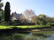
AESTHETIC VALUE Westbrook is a simple cottage with pleasing lines that are symmetrical through the roof line and the chimneys located at either end of the hipped roof. The balanced proportions of the building lend it a simple elegance that is enhanced by its sylvan setting. HISTORIC ALUE Westbrook is associated with the historical development of Busselton, particularly the period of consolidation when the community had survived the initial struggle of establishing farms iin an unknown land and repelling hostile natives who resented their presence. At the time of Dawsons purchase of Westbrook, the community had weathered hard times and was expanding outwards, permitting the settlers to move away from the confines of the initial settlement. Westbrook is closely associated with Elijah Dawson who was one of the first settlers in the Busselton area. Dawson was a valuable assistant not only to Captain Molloy, but also to the Bussell family. He assisted both families in the establishment of their properties at the Vasse, before establishing his own farms at Wonnerup and then Westbrook, He was an important figure ein the local community, holding the post of Constable for over ten years. SCIENTIFIC VALUE Westbrook has the potential to yield valuable archaeological evidence. This evidence cooud be found beneath the floorboards of the building itself, around the immediate vicinity of the building and beyond. The site has the potential to yield information about the lifeways of the occupants as well as past farming practices. SOCIAL ALUE Westbrook contributes to the Busselton community’s sense of place as it is an important component of the area’s historical development. The place embodies the past endeavours of early settlers in overcoming hardships and consolidating their properties, thus enabling the community to move forward into economic prosperity. This feeling is enhanced by the place’s association with Elijah Dawson who is considered to be an important early settler. RARITY The degree to which Westbrook has retained its high level of integrity and authenticity is unusual in a building of this age. Very few buildings of this vintage have survived in the Busselton district with this level of integrity and authenticity. Timber kitchens were located away from the main house as they so often had a tendency to burn down. The survival of the wooden kitchen is also unusual. REPRESENTATIVENESS The building is representative of the dwellings erected by the early settlers in the Busselton district. These buildings were unpretentious and designed to be functional. CONDITION In 1998, the building is in excellent condition considering its age and has obviously been well cared for. There is evidence of cracking to the corridor wall at the southern end on the western side, close to the ceiling. Some cracks are also visible in room 3. All of the cracks appeared following the Meckering earthquake (1968) and no further movement has occurred since. The walls of room 3 have a high salt content due, it is thought, to the storage of salt sacks against the outside wall of this room. INTEGRITY The original plan of the building has been retained with only minimal changes. Considering the long history of the building it is unusual that the verandah has been retained to nearly its original extent with only the western side becoming enclosed. The enclosure of the western verandah has given the building additional space but has not compromised the rest of the building. This enclosure and the glass enclosure at the rear could easily be removed at a later date if desired. The building was originally designed to be used as a farm residence and it continues to be used for this purpose. Westbrook has retained a high degree of integrity. The detached kitchen has retained its original plan, although at present it is not being used. It is considered to have a high degree of integrity. AUTHENTICITY The building has retained much of the original floor plan, interior wall and ceiling fabric and original fittings. Some of the window panes may also be original. The replacement of the verandah posts and floor and the new roof cladding in no way detracts from the authenticity of the place as they represent the ongoing care that has been nestowed on the building. The enclosure of the western verandah and a portion of the rear verandah represent the continuing gentle development of the place and the changing needs of its occupants. Westbrook has retained a high degree of authenticity. The interior of the slab kitchen has been re-clad with gyprock sheets and a new zincalum shed has been attached to the southern side. These alterations are not however considered to be major and therefore the kitchen is thought to have a high degree of authenticity.
Westbrook is a simple Victorian Georgian building, constructed of soft-fired bricks, aid using English bond with a verandah to all four sides. The hip roof is covered with terracotta Marseilles tiles. The building is surrounded by open farmland which is used for sheep grazing. North of the house are a number of old fruit trees, whilst at the rear of the house is a very old fig tree. South and East of the house are more recent farm buildings, At the rear of the house (south) is an old slab kitchen with a shed attached to the southern side. The exterior of the building features soft brick walls on an ironstone foundation. The wide verandah roof is supported on timber posts and has a timber floor. During the 1950s the Taylors replaced the corrugated galvanized iron cladding with terracotta tiles. Prior to the iron cladding, the roof was probably covered with shingles. A scalloped timber valance below the line of the main roof probably belongs to the period when the roof was covered with shingles. The timber posts and the verandah floor were also repaired and replaced when the roof was recovered. Under floor ventilation was also installed at this time. Two brick chimneys are located at either end of the roof. The front of the house faces north and the main door is flanked by two windows on the western side and one window on the eastern side. The four panel front door has a fanlight of coloured glass and the original rim lock is still in situ. Evidence of the skills of a master builder can be seen in the brick arches above the window and door openings. The western verandah area has been enclosed with asbestos cement sheets to form three rooms and an extension at the rear contains a toilet and bathroom. These alterations are thought to have been carried out in the 1940s. However the toilet area was modified in the 1960s when the Feutrills occupied the house. The internal plan features a central passage with rooms opening onto it. The windows are double hung sashes with 6 panes. The timber frame is held together with pegs. Original features include window furniture, mantle pieces to the fireplaces in the front room, skirting boards, internal doors with rim locks. The western portion of the rear verandah area has been enclosed with glass partitions and a kitchen extends beyond the line of the rear verandah. Access to the kitchen from the main house is via a pair of French doors from room 4. The kitchen was added during the 1960s and this room, together with the bathroom and toilet has been recently modernised. The original detached kitchen is located close to the rear wall of the new kitchen. It is constructed from vertical timber slabs. The gable roof is covered with corrugated Galvanised iron. The interior is divided into two rooms: the larger eastern room was apparently the kitchen area and has a large open fireplace constructed from brick. Access to the smaller eastern room is via a low door set on the south side of the wall. The interior walls ae lined with gyprock. Sharing a portion of the kitchen’s southern wall is a new zincalum shed.
Assessment 1998 Constructed: 1863 - 1866 and c.1850s Builder: not known, possibly Christopher Weetman Westbrook was possibly constructed by Christopher Weetman for the Dawson family between 1863 and 1866. It is a single storey brick and tile building with verandahs to all four sides. An old slab kitchen (construction date not know) is located at the rear of the house. Busselton was first settled by the Bussell family in 1834. The Bussells originally settled at Augusta, later moving to the Vasse when they discovered that this area had better farmland. By 1839, the majority of the Augustan settlers had moved away, many of them settling at the Vasse. The settlement came to be referred to as Busselton and the town was declared in 1839. The settlers initially had problems with hostile aboriginals, restricting settlement around a central area occupied by the Bussells. The settlers soon discovered that they could carry out an active trade with American whaling ships. In return for fresh produce, the whaling ships provided commodities unavailable to the settlers. By the 1850s, the settlement had grown, attracting tradesman and a local whaling station was established near Dunsborough (Castle Rock). As the settlement grew, the aboriginal population began to decline and hostilities decreased, permitting settlers to move further away from the initial settlement. Elijah Dawson arrived in the Swan River colony in 1830 aboard the Warrior. Dawson has served with Capain John Molloy as a corporal during the Battle of Waterloo. When Molloy decided to emigrate, Dawson elected to follow him and signed on as n indentured servant for five years. Prior to leaving England he married Ann Wakeham. The Dawsons settled in Augusta with the Molloys and were considered to be trustworthy servants; Ann helped Giogiana with her household chores. In return for their loyalty, they were allocated a lot in Augusta and were given permission to use 14 acres on Molloy’s allotment. When the Bussells moved to the Vasse in 1834, Elijah went with the family as a hired hand. In 1835, Dawsons indenture to the Molloys (and the Bussells) expired and he returned to his family at Augusta. He was keen to acquire land on the Vasse and on 13 October 1836 he purchased suburban Lot 7 for £3, and settled there with his family. In 1837 the Dawsons were forced to flee from their home due to the actions of hostile Aboriginals; they sheltered temporarily with the Bussells. By 1838, Dawson had acquired a property in Wonnerup on which he built a house. While at Augusta, Dawson had been appointed Constable in 1835. However once the settlement was abandoned this position was abolished and he was appointed Constable for Busselton, a position he held until 1848. Dawson purchased Sussex Location 12 (600 acres) from Thomas Turner on 20 April 1846 for £120 and named the property Westbrook. According to Hasluck, the Dawsons initially erected a nine room wattle and daub cottage with a thatched roof. It is not known what Hasluck’s source of information was and nine rooms would make a sizeable building. According to Feutrill, family history records that Turner assisted Dawson in obtaining Sussex Location 12 by purchasing the property for him in 1843. Shortly after this first cottage, they constructed a brick building. The family prospered on this location, they raised cattle, cultivated crops and planted 3 acres of vines. The wine made from these grapes was apparently sold to Charles Keyser, an American who had established a timber mill (Wilgamup) a few miles from Westbrook. Dawson died in 1885 and was survived by five children. The date of construction of Westbrook and the name of the builder cannot be said to be firmly ascribed. An article by Sansom, G., Hammond, R. and Gillett, P.H. considers the builder to be James Weetman and notes that an exact date of construction is impossible to define, but considers that is was somewhere between 1844 and 1848. This close date is given as Weetman drowned in 1849. This date seems rather early as Dawson only purchased the property in 1846 and had apparently constructed a nine room wattle and daub cottage. A further problem with both the date and the builder proposed by Sansom, Hammond and Gillett is that there is no James Wheetman listed in the “Bicentennial Dictionary”. Erickson does list a Christopher Weetman who was a mason and master bricklayer. He employed two ticket-of-leave men in 1863 and 1866 in the Sussex district; he drowned in 1867. Erikson notes that Dawson’s son Elijah (Jnr) was a farmer at Westbrook and employed three or more ticket-of-leave men between 1863 and 1866. The coincidence here seems interesting. Brian Feutrill, the current occupant of Westbrook related that the bricks used in the construction of the house had been made on the property. The construction of a brick house would have required several persons: to dig the clay for the bricks, forming the bricks, firing the bricks and it would have been necessary to burn shells for the lime required in the mortar. Al this before the actual construction of the house. Dawson’s children in 1846 were all fairly young. It seems more likely that the house was constructed sometime between 1863 and 1866 when the Dawsons could make use of ticket-of-leave men in their employ and it is possible that Christopher Weetman was the builder. After the completion of the brick house, the wattle & daub building was used as a storeroom and kitchen until it burnt down in c1850s. Hasluck gives no date for this event. There is no historical information regarding the detached kitchen. However, Doug Feutrill states that according to information told to his grandfather by Elijah Dawson (Jnr), the kitchen was constructed immediately after the demose of the wattle and daub building as the family now had no kitchen. Feurill also notes that the vertical slabs used in the buildings construction are pit-sawn, indicating that the Dawsons obtained the wood from Keyser’s Mill, which was located approximately five miles from Dawsons house. Yelverton established his mill in 1856/7 and used a stem driven circular saw wile Keyser’s mill produced sawn with a pit saw. This makes it highly likely that the detached kitchen was constructed during the 1850s. Westbrook was sold by the Dawsons to W.D. Taylor in 1904. Taylor apparently enclosed the western verandah creating two additional rooms to the side of the house and a laundry at the rear. I 1905/6, Taylor re-clad the roof with corrugated galvanized iron and re-aligned the main roof rafters which had begun to spread. More extensive work was carried out on the roof in 1957 when it, and the verandah were completely removed to enable the walls to be tied back together. All the roof timbers were returned to their original locations, as were the verandah timbers. The roof was re-clad with clay tiles due to the prohibitive costs of installing shingles. Underfloor ventilation was installed to the verandah foundations and a new timber floor installed. Taylor sold the property to his nephew, D.E. Feutrill in 1964. The laundry, which Taylor had installed was altered to a toilet and bathroom. A new laundry was added onto the southern end of the new bathroom and a kitchen was added to the eastern side of the new laundry. During Mr & Mrs D. Feutrill’s occupancy, their son Brian occupied the detached kitchen, using the room next to the kitchen as a bedroom.
The building and detached kitchen are considered to have a high degree of integrity
This information is provided voluntarily as a public service. The information provided is made available in good faith and is derived from sources believed to be reliable and accurate. However, the information is provided solely on the basis that readers will be responsible for making their own assessment of the matters discussed herein and are advised to verify all relevant representations, statements and information.
Constructed from 1863, Constructed from 1866
Westbrook Homestead, a single storey brick and tile residence in the Victorian Georgian style, together with a slab construction kitchen and a herringbone stall split timber dairy, has cultural heritage significance as an excellent example of a simple Victorian Georgian residence designed to take into account of the Australian climate. The place is a good indication of the early development of the Busselton area and has historical associations with Elijah Dawson, a Waterloo veteran who settled in the area. The place has strong archaeological potential. The herringbone stall dairy is rare and the collection of elements has high aesthetic value. The place also provides evidence of the adaptation of imported styles to suit the local environment.
Westbrook is a simple Victorian Georgian style building constructed in soft red brick in English bond coursing, with a verandah on all four sides. The hipped roofs are covered with Marseilles pattern terracotta tiles. The building is surrounded by open farmland with plantings of fruit trees. There is an old timber slab kitchen to the south of the house.
Westbrook Homestead was built between 1863 and 1866 for the Dawson family. A slab cottage constructed in the 1850s stands at the rear of the house. Elijah Dawson arrived in the Swan River Colony in 1830 per the Warrior and had served with John Molloy at Waterloo. Dawson was indentured to Molloy and settled in Augusta and moved to Vasse with Molloy in 1834. Dawson purchased Westbrook from Thomas Turner in 1846. The place was sold to William Taylor in 1906 and in 1920, a dairy was added and then replaced with a new dairy in 1938. In 1964 the Feutrill family acquired the place.
High Degree/High Degree Integrity Notes: The place retains a high degree of integrity although there have been some modifications to the place. Authenticity Notes: The place retains a high degree of authenticity.
Good
| Owner | Category |
|---|---|
| DE & D Fuetrill | Other Private |
This information is provided voluntarily as a public service. The information provided is made available in good faith and is derived from sources believed to be reliable and accurate. However, the information is provided solely on the basis that readers will be responsible for making their own assessment of the matters discussed herein and are advised to verify all relevant representations, statements and information.
22 Kent St West Busselton
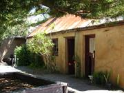
Bond Store & Custom Officer's Residence
The Gulch; Police Residence
Busselton
South West
Constructed from 1856
| Type | Status | Date | Documents |
|---|---|---|---|
| Heritage List | YES | 13 Aug 2014 | |
| State Register | Registered | 08 Jan 2010 | HCWebsite.Listing+ListingDocument, HCWebsite.Listing+ListingDocument |
| Type | Status | Date | Documents |
|---|---|---|---|
| (no listings) |
| Type | Status | Date | Grading/Management | |
|---|---|---|---|---|
| Category | ||||
| Register of the National Estate | Indicative Place | |||
| Classified by the National Trust | Recorded | 02 Feb 1976 | ||
| Municipal Inventory | Adopted | 20 Jun 1996 | Category 1 | |
Overall, the place is in fair condition. The condition of the place has deteriorated since the conservation plan was undertaken, largely as predicted by that plan. The roofing sheets are corroding and only one small section of unserviceable guttering remains insitu. Some cracks in the external render have enlarged to holes through which the hand-made bricks of the building can be seen eroding, exacerbated by water leakage from the c.1980s plumbing, rising damp and falling damp. A narrow garden bed runs along the front of the buildings (adding an additional source of potential moisture ingress) and there is some evidence of plants self-seeding along the other the walls. All the external doors are in poor condition and showing evidence of deterioration due to exposure to the elements. The door to Room Three (northern room) has entirely lost its glazing and one lower panel, and the remaining timber in warped and broken. Two of the sixteen glazed panels in the window to Room Two (central room) are missing. Internally, the pressed metal ceiling panels are rusting, especially in Room Three, and cracking and/or buckling, especially in Rooms One (south room) and Two. There is some deterioration of the timbers in the doorframe between Room Two and Room One. Internal rendering appears largely intact. It is not possible to determine the structural integrity of the bricks hidden by the rendering, although where cracks reveal them they are deteriorating. The place appears to be reasonably structurally sound. The house at 22 Kent Street, in whose backyard The Gulch is situated, is an Interwar weatherboard and fibrous cement residence, in good condition.
| Library Id | Title | Medium | Year Of Publication |
|---|---|---|---|
| 4072 | Conservation Plan for The Gulch. | Heritage Study {Cons'n Plan} | 1999 |
Individual Building or Group
| Epoch | General | Specific |
|---|---|---|
| Other Use | GOVERNMENTAL | Police Station or Quarters |
| Original Use | GOVERNMENTAL | Customs House\Bond Store |
| Present Use | RESIDENTIAL | Other |
| Style |
|---|
| Victorian Georgian |
| Federation Bungalow |
| Type | General | Specific |
|---|---|---|
| Wall | BRICK | Rendered Brick |
| Roof | METAL | Corrugated Iron |
| General | Specific |
|---|---|
| DEMOGRAPHIC SETTLEMENT & MOBILITY | Settlements |
| OUTSIDE INFLUENCES | Markets |
| OCCUPATIONS | Domestic activities |
| DEMOGRAPHIC SETTLEMENT & MOBILITY | Government policy |
| SOCIAL & CIVIC ACTIVITIES | Law & order |
| SOCIAL & CIVIC ACTIVITIES | Government & politics |
This information is provided voluntarily as a public service. The information provided is made available in good faith and is derived from sources believed to be reliable and accurate. However, the information is provided solely on the basis that readers will be responsible for making their own assessment of the matters discussed herein and are advised to verify all relevant representations, statements and information.
Constructed from 1854, Constructed from 1856
Custom officer’s house and police station 'The Gulch' has cultural heritage significance as one of the few remaining early private buildings designed in Victorian Georgian style in the town centre. It is also significant for its association with the early government administration of Busselton, in particular Captain John Molloy and Joseph Strelly Harris who were both resident magistrates for the Sussex District.
A rendered brick walled cottage with a steeply pitched iron roof at the rear of the lot and a timber framed and clad cottage at the front of the lot. There is also a low squat chimney located slightly off centre of the main ridge line. A three-roomed cottage with rendered brick walls inside and out. It has a pressed metal ceiling and concrete flooring. The roof was framed for shingles, which have been replaced with iron.
According to Busselton Historical Society notes, the place was built in the convict period as a customs officer’s residence and added to in 1906. John Molloy built the customs house during 1856, primarily as a warehouse space for bonded goods, with additional rooms for a guard and an office for the Resident Magistrate. Comments by the Colonial Secretary’s Office and Molloy and delays relating to its completion indicate that the building was purpose built. Subsequently a larger bond store and office space was built for the Resident Magistrate elsewhere and the place appears to have been used for residential purposes from 1861.
Moderate Degree/Moderate Degree Integrity Notes: The residential nature of the place remains apparent. The integrity of the place is moderate. Authenticity Notes: Both buildings have had minor modifications so that the place retains a moderate degree of authenticity.
Rear Cottage- Fair. Front Cottage- Good
| Ref ID No | Ref Name | Ref Source | Ref Date |
|---|---|---|---|
| Conservation Plan | 1999 |
| Owner | Category |
|---|---|
| D & J Yates | Other Private |
This information is provided voluntarily as a public service. The information provided is made available in good faith and is derived from sources believed to be reliable and accurate. However, the information is provided solely on the basis that readers will be responsible for making their own assessment of the matters discussed herein and are advised to verify all relevant representations, statements and information.
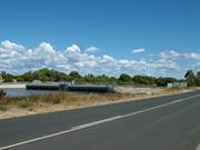
Layman Rd Wonnerup
Wonnerup Wetlands
Busselton
South West
Constructed from 1871, Constructed from 1991
| Type | Status | Date | Documents |
|---|---|---|---|
| State Register | Registered | 03 Jun 2005 | HCWebsite.Listing+ListingDocument, HCWebsite.Listing+ListingDocument |
| Type | Status | Date | Documents |
|---|---|---|---|
| (no listings) |
| Type | Status | Date | Grading/Management | |
|---|---|---|---|---|
| Category | ||||
| Aboriginal Heritage Sites Register | Interim | |||
| Aboriginal Heritage Sites Register | Permanent | |||
05358 Route of the Ballarat Railway Line
In April 2004, Ballarat Bridge was removed, Vasse Floodgates were replaced and Wonnerup Floodgates were replaced except for the south abutment and infill wall.
| Library Id | Title | Medium | Year Of Publication |
|---|---|---|---|
| 7061 | Vasse/Wonnerup Floodgates & Ballarat Bridge (fmr) : heritage assessment. | Heritage Study {Other} | 2003 |
| 6869 | Vasse and Wonnerup Floodgates : photographic record. | Archival Record | 2004 |
| 7266 | Vasse and Wonnerup floodgates replacement : construction phase, selected photographs, heritage photo summary. | Heritage Study {Other} | 2004 |
Historic site
| Epoch | General | Specific |
|---|---|---|
| Present Use | Transport\Communications | Rail: Other |
| Original Use | GOVERNMENTAL | Reservoir or Dam |
| Original Use | Transport\Communications | Rail: Other |
| Present Use | Transport\Communications | Water: Other |
| Style |
|---|
| Other Style |
| Type | General | Specific |
|---|---|---|
| Other | TIMBER | Other Timber |
| Other | METAL | Other Metal |
| General | Specific |
|---|---|
| TRANSPORT & COMMUNICATIONS | Rail & light rail transport |
| DEMOGRAPHIC SETTLEMENT & MOBILITY | Environmental change |
This information is provided voluntarily as a public service. The information provided is made available in good faith and is derived from sources believed to be reliable and accurate. However, the information is provided solely on the basis that readers will be responsible for making their own assessment of the matters discussed herein and are advised to verify all relevant representations, statements and information.
This information is provided voluntarily as a public service. The information provided is made available in good faith and is derived from sources believed to be reliable and accurate. However, the information is provided solely on the basis that readers will be responsible for making their own assessment of the matters discussed herein and are advised to verify all relevant representations, statements and information.
935 & 936 Layman Rd Wonnerup
Includes: House B1 and B2, Blacksmith's Shop, Stables, School Room, Teacher's House, Memorial Gates, Warden's Cottage, Tea Rooms, Abergeldie Cottage and the landscape.
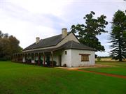
Wonnerup House and Grounds
Busselton
South West
Constructed from 1837 to 1859
| Type | Status | Date | Documents |
|---|---|---|---|
| Heritage List | YES | 13 Aug 2014 | |
| State Register | Registered | 08 Oct 1996 | HCWebsite.Listing+ListingDocument, HCWebsite.Listing+ListingDocument |
| Type | Status | Date | Documents |
|---|---|---|---|
| (no listings) |
| Type | Status | Date | Grading/Management | |
|---|---|---|---|---|
| Category | ||||
| Municipal Inventory | Adopted | 20 Jun 1996 | Category 1 | |
| Aboriginal Heritage Sites Register | Permanent | |||
| Classified by the National Trust | Classified | 11 Jun 1973 | ||
03368 Wonnerup Townsite Precinct
The place is in very good condition.
| Library Id | Title | Medium | Year Of Publication |
|---|---|---|---|
| 4636 | A Nyungar interpretation of Ellensbrook and Wonnerup homesteads. | Heritage Study {Other} | 1994 |
| 6747 | The story of Wonnerup House. | Brochure | 1973 |
| 555 | Conservation of Wonnerup House Busselton : conservation works. | Heritage Study {Other} | 1994 |
| 1031 | Conservation Plan for Wonnerup Homestead Western Australia. | Heritage Study {Cons'n Plan} | 1995 |
| 6748 | The story of Wonnerup House. | Brochure | 1980 |
| 7189 | Very much on watch : the Percy Willmott photos : Augusta, Margaret River, Busselton 1901 - 1919. | Book | 2003 |
Individual Building or Group
| Epoch | General | Specific |
|---|---|---|
| Original Use | FARMING\PASTORAL | Other |
| Original Use | FARMING\PASTORAL | Homestead |
| Present Use | EDUCATIONAL | Museum |
| Style |
|---|
| Victorian Georgian |
| Type | General | Specific |
|---|---|---|
| Roof | TIMBER | Shingle |
| Wall | STONE | Limestone |
| Wall | BRICK | Common Brick |
| General | Specific |
|---|---|
| PEOPLE | Early settlers |
| TRANSPORT & COMMUNICATIONS | Rail & light rail transport |
| OCCUPATIONS | Grazing, pastoralism & dairying |
| PEOPLE | Aboriginal people |
| OCCUPATIONS | Timber industry |
This information is provided voluntarily as a public service. The information provided is made available in good faith and is derived from sources believed to be reliable and accurate. However, the information is provided solely on the basis that readers will be responsible for making their own assessment of the matters discussed herein and are advised to verify all relevant representations, statements and information.
Constructed from 1837, Constructed from 1859
The Wonnerup House & grounds, a finely designed cluster of buildings in a well kept landscape has cultural heritage significance because it demonstrates the principal characteristics of nineteenth century homesteads associated with the spread of European settlement throughout the State’s south west. The schoolroom and teacher’s house demonstrate Government involvement in education in the district between 1872 and 1912. The place is associated with the opening of the Ballarat timberline in 1871 and the railway link to Busselton in 1895, events that had great impact on the development of local farming and timber industries. The place is significant as the site of the spearing of George layman (the elder) an event that demonstrates the mixed relationship and attitudes between the local Aborigines and the European settlers at the time. The place is significant for its close associations with the Layman family, with Robert Heppingstone and with the Molloy family. The whole of the place has aesthetic qualities that are valued by the community. The cultivated gardens around the homestead and the school precincts and the beauty imparted by the Tuart forest to the south and belt of Melaleucas at the edge of the edge of the estuary flats contribute to the aesthetic values of the setting. The homestead and school precincts have landmark qualities and the introduced buildings, while not being directly associated with the place have historical significance in their own right.
The building is a part of the Wonnerup Precinct comprising two farmhouses, a Blacksmith’s Shop, stables, School Room, Teacher’s House, Memorial Gates, Warden’s Cottage, Tea Rooms, Albergeldie Cottage and the landscape. Wonnerup House consists of the main farmhouse, the kitchen and the barn and byre. The kitchen contains a bread oven, wooden washtubs and cheese press. Close by, mature Melaleuca trees sit at the edge of the estuary flats and landscaped gardens around the Homestead and School. At the entrance to the property, a pair of gates sits to commemorate George Layman. The place collection of buildings comprising House (B1, pre 1859), a limestone and brick wall structure with a timber shingled roof, House (B2 1859+), a limestone walled structure with a timber shingled roof, Blacksmith’s Shop (B3) a limestone structure with a corrugated iron roof, Stables (B4) a rubble stone walled structure with a corrugated iron roof, School Room (B7 1873) and Teacher’s House (B8 1884), both timber framed and roofed with timber shingles, Memorial Gates B10 1934) of wrought iron, Warden’s Cottage (B5 transferred to site 1972) a timber framed and corrugated iron roofed structure, Tea Rooms (B6 transferred to site in 1972) a timber framed and clad structure, Albergeldie Cottage (B9 1922, transferred to site 1984) a timber framed and corrugated iron roof structure in a well kept landscaped setting. Other buildings such as toilets garage and workshop are also located on the site but are not considered to be important. The Ballarat tramline plaque and wheel are now located at Wonnerup House.
George Layman first established the entire farming complex in 1837. The main farmhouse was erected using limestone and pit sawn timber in 1859. Subsequently, Jim Layman added the limestone stables in c. 1900. The second group of buildings consisting scullery, dairy, cellar and kitchen was added. The third building, the barn and byre were the last addition. In the late 20th century, other buildings were relocated to the place as listed below.
High Degree/High Degree Integrity Notes: The place retains a high degree of integrity. Authenticity Notes: The place retains a high degree of authenticity.
Very Good
| Owner | Category |
|---|---|
| National Trust Australia | Inc. Non-profit body |
This information is provided voluntarily as a public service. The information provided is made available in good faith and is derived from sources believed to be reliable and accurate. However, the information is provided solely on the basis that readers will be responsible for making their own assessment of the matters discussed herein and are advised to verify all relevant representations, statements and information.
Significant very early farm complex restored by the National Trust. Built in 1859 on the site of the original building of about 1837. Schoolhouse significant because of historical connection with Wonnerup house and its founders. An example of a one teacher school, as a type. An example of early schools being 'sponsored' by local landowners.
Wonnerup House Main Building: Limestone and pit-hewn timber. limestone stables (about 1900) added by Jim Layman. Second Building: containing scullery, dairy, cellar and kitchen. Scullery contains bread oven, wooden wash tubs and cheese press Third Building: barn and byre OLD SCHOOL AND TEACHERS HOUSE Single room school house. Separate two room teachers house, of weatherboard, shingle roof and visible from the road opposite Wonnerup house.
Assessment 1967 Construction: 1859 - main building; c. 1837 - another building still standing to which 2 brick rooms were later added. Builder: Mr George Layman SCHOOL HOUSE: construction c.1873 - 75
This information is provided voluntarily as a public service. The information provided is made available in good faith and is derived from sources believed to be reliable and accurate. However, the information is provided solely on the basis that readers will be responsible for making their own assessment of the matters discussed herein and are advised to verify all relevant representations, statements and information.
936 Layman Rd Wonnerup
In the grounds of Wonnerup House, Layman Road, Wonnerup. REGISTERED AS PART OF 0424
Old Wonnerup School & Teacher's House
Busselton
South West
Constructed from 1873 to 1884
| Type | Status | Date | Documents |
|---|---|---|---|
| Heritage List | YES | 13 Aug 2014 |
| Type | Status | Date | Documents |
|---|---|---|---|
| (no listings) |
| Type | Status | Date | Grading/Management | |
|---|---|---|---|---|
| Category | ||||
| Municipal Inventory | Adopted | 20 Jun 1996 | Category 1 | |
| Classified by the National Trust | Classified | 02 Sep 1974 | ||
| Register of the National Estate | Permanent | 21 Mar 1978 | ||
00424 Wonnerup Precinct
The place is in good condition.
| Name | Type | Year From | Year To |
|---|---|---|---|
| Public Works Department | Architect | 1873 | 1884 |
| Library Id | Title | Medium | Year Of Publication |
|---|---|---|---|
| 1031 | Conservation Plan for Wonnerup Homestead Western Australia. | Heritage Study {Cons'n Plan} | 1995 |
Individual Building or Group
| Epoch | General | Specific |
|---|---|---|
| Other Use | EDUCATIONAL | Housing or Quarters |
| Present Use | EDUCATIONAL | Primary School |
| Original Use | SOCIAL\RECREATIONAL | Other |
| Style |
|---|
| Victorian Georgian |
| Type | General | Specific |
|---|---|---|
| Roof | TIMBER | Shingle |
| Wall | TIMBER | Weatherboard |
| General | Specific |
|---|---|
| SOCIAL & CIVIC ACTIVITIES | Education & science |
This information is provided voluntarily as a public service. The information provided is made available in good faith and is derived from sources believed to be reliable and accurate. However, the information is provided solely on the basis that readers will be responsible for making their own assessment of the matters discussed herein and are advised to verify all relevant representations, statements and information.
Constructed from 1874, Constructed from 1873
Wonnerup School & Teacher’s house, a set of timber buildings in the Victorian Georgian style has cultural heritage significance for their close historic associations with the Wonnerup House and its founders, the Layman family. They exemplify the local building style of the late 19th century, resting on land once belonging to George Layman, a local landowner. He was also one of the sponsors of the school that operated from 1874 t0 1912. The growth of the school and teacher’s house was a mirror of the development of the local farming and timber industries. The schoolroom and teacher’s house demonstrate Government involvement in education in the district between 1872 and 1912. Today, the School Room Precinct remains to be a significant visual landmark.
Timber framed and timber shingled roofed buildings in a landscaped setting. The two buildings consisting the school and the teacher’s house rest in a L-shaped manner within a timber fence enclosure. Both buildings were designed in the Victorian Georgian architectural style with timber weatherboard cladding and timber shingle roofing.
In 1873, the site was granted for educational use and upon completion the school became the bustling pedagogic venue for local residents. The teacher’s house was added in 1884.
High Degree/High Degree Integrity Notes: The place retains a high degree of integrity. Authenticity Notes: The place retains a high degree of authenticity.
Good
| Owner | Category |
|---|---|
| National Trust Australia | Inc. Non-profit body |
This information is provided voluntarily as a public service. The information provided is made available in good faith and is derived from sources believed to be reliable and accurate. However, the information is provided solely on the basis that readers will be responsible for making their own assessment of the matters discussed herein and are advised to verify all relevant representations, statements and information.
Significant very early farm complex restored by the National Trust. Built in 1859 on the site of original building of about 1837. One example of a one teacher schools, as a type. An example of the early practice of schools being 'sponsored' by local landowners.
Single room School House. Separate 2 room Teachers house. Weather board, shingle roof and visible from road opposite the gated to Wonnerup House. Historical significance because of connection with Wonnerup House and its founders. Main Building: Limestone and pit sawn timber. Limestone stables added by Jim Layman about 1900 Second Building: containing scullery, dairy, celar and kitchen. Scullery contains bread oven, wooden wash tubs and cheese press. Third Building: barn and byre
Assessment 1967 Original owner: Mr George Layman Date of original construction 1859 (main building), about 1837 - another building still standing to which two small brick rooms were later added. Builder: Mr George Layman
This information is provided voluntarily as a public service. The information provided is made available in good faith and is derived from sources believed to be reliable and accurate. However, the information is provided solely on the basis that readers will be responsible for making their own assessment of the matters discussed herein and are advised to verify all relevant representations, statements and information.
Ruabon Rd Wonnerup
Busselton
South West
Constructed from 1871, Constructed from 1971
| Type | Status | Date | Documents |
|---|---|---|---|
| (no listings) |
| Type | Status | Date | Documents |
|---|---|---|---|
| (no listings) |
| Type | Status | Date | Grading/Management | |
|---|---|---|---|---|
| Category | ||||
| Municipal Inventory | Adopted | 20 Jun 1996 | Category 5 | |
00424 Wonnerup Precinct
Other Built Type
| Epoch | General | Specific |
|---|---|---|
| Original Use | Transport\Communications | Rail: Other |
| Present Use | Transport\Communications | Rail: Other |
| General | Specific |
|---|---|
| TRANSPORT & COMMUNICATIONS | Rail & light rail transport |
| OCCUPATIONS | Timber industry |
This information is provided voluntarily as a public service. The information provided is made available in good faith and is derived from sources believed to be reliable and accurate. However, the information is provided solely on the basis that readers will be responsible for making their own assessment of the matters discussed herein and are advised to verify all relevant representations, statements and information.
Constructed from 1871, Constructed from 1971
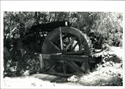
Ballarat Tramline Plaque & Wheel (Locomotive) has cultural heritage significance as a memorial to the introduction of new technology in the timber industry and the expansion of the state’s infrastructure.
Engine wheel and concrete base, with plaque. grounds of Wonnerup House.
The memorial commemorates the centenary of the first railway in Western Australia. The railway ran from Lockeville, Wonnerup to Yoganup and was operated by the WA Timber Company and opened in 1871. The Ballarat engine was the first train to be used in W.A. It was manufactured in Ballarat, Victoria in 1871. It was used by the West Australian Timber Co. for 15 years at Lockeville, Wonnerup to Yoganup, and eventually brought into Busselton for display and interpretive purposes. The commercial harvesting of fine hardwood timbers from the forests nearby Busselton began in the late 1840s with the logs being shipped from McGibbon’s jetty near Quindalup. As the demand for timber increased its viability as an export commodity was soon recognized by the Colony’s new Governor, Frederick Aloysius Weld, who arrived in 1869. The Jarrah, or Western Australian Mahogany, is only found in this Colony; it is unrivalled for railway sleepers; it is extraordinarily durable; in water it resists the attacks of the Teredo Navalis, and on land those of the white ant. There is a very large demand for it from India and the neighboring Colonies, which cannot be supplied from want of facilities for conveying the timber from the forests, and for shipping it.49 Weld wanted to encourage large-scale development of the State’s massive timber resources by replacing the existing system of short-term licenses with long-term leases or concessions that would attract outside investors, in particular from Victoria where considerable wealth had been generated from the gold rushes of the 1850s and 1860s.50 Following negotiations with the syndicates involved, the Home Office granted three concessions. Each company had to provide its own mill, railway and port for shipping the timber. The West Australian Timber Company (referred to as the Ballarat Company in one contemporary account)51 was granted a concession of 181,500 acres at Yokanup (now referred to as Yoganup) with its seaport at Lockeville. The other syndicates were the Canning Jarrah Timber Company that was granted a concession on the Canning River where an existing wharf was used, and the Rockingham Jarrah Company’s concession at Jarrahdale with its port at Rockingham. The agreement between the West Australian Timber Company and the government was signed on 29 July 1871. John McNeil operated as the company’s agent in Western Australia and was based at Lockeville, where he oversaw the construction of the jetty and railway, which would have included the building of the railway bridge over the Vasse estuary in order to take the line across to the jetty. To date, no reference has been found for the construction of the railway bridge that carried the rail line across the narrow channel (where the Vasse estuary joins the Wonnerup Inlet) to the jetty. It was a matter of local satisfaction that the Vasse could boast having the first locomotive and railway line in the State. In describing how the mill was progressing, a ‘correspondent’ in the 21 April 1871 edition of The Inquirer remarked: We are anxiously looking for the arrival of the vessel from Melbourne bringing the locomotive for the W. A. Timber Coy railway. The works are progressing rapidly and it is rumored and generally believed, that His Excellency the Governor will pay us a visit for the purpose of opening the railway and saw mills on the 1st May. This will be a happy May Day for us and it may be easily imagined that we feel no small satisfaction in having this first railroad of the Colony within our district. Governor Weld officially opened the railway line on 23rd December 1871, while the Jarrahdale-Rockingham line was opened in November 1872. The Mayor of Melbourne originally named the locomotive ‘Ballarat’ after the original spelling of the town of Ballarat where it was built by James Hunt at the Victoria Foundry (now Phoenix Foundry). ‘It had a horsepower of 16 and had two cylinders of 7 inch diameter and a 14 inch stroke. Three wagons without springs were used on the timber train.’52 The timber had been hauled along the rails, originally made of jarrah, by horses before the arrival of the locomotive. Horses and later bullocks continued to be used in conjunction with the engine.
Site Only
| Ref ID No | Ref Name | Ref Source | Ref Date |
|---|---|---|---|
| Votes & Proceedings 1870. Transcript of letter | 13 October 1869 | ||
| "Oxford Companion to Australian History", p 287 | |||
| "Western Australia- an Atla of Human Endeavour 1829-1979", p 69 | Education and Lands and Surveys Department of WA for the Education Committee, | 1979 | |
| Jennings R;"A Place to Remember", 1850-1914 p 127 | Shire of Busselton | 1999 | |
| "Grants of Land and other Concessions, Cutting Timber to Export", p 8 | |||
| W.A.G.R. Newsletter;‘Centenary of the State’s First Railway’ | May 1971 |
| Owner | Category |
|---|---|
| CALM | State Gov't |
This information is provided voluntarily as a public service. The information provided is made available in good faith and is derived from sources believed to be reliable and accurate. However, the information is provided solely on the basis that readers will be responsible for making their own assessment of the matters discussed herein and are advised to verify all relevant representations, statements and information.
57 Abbeys Farm Rd Yallingup
Registration listed as Abbey Farm Rd
Busselton
South West
Constructed from 1864 to 1877
| Type | Status | Date | Documents |
|---|---|---|---|
| Heritage List | YES | 13 Aug 2014 | |
| State Register | Registered | 13 Dec 1996 | HCWebsite.Listing+ListingDocument, HCWebsite.Listing+ListingDocument |
| Type | Status | Date | Documents |
|---|---|---|---|
| (no listings) |
| Type | Status | Date | Grading/Management | |
|---|---|---|---|---|
| Category | ||||
| Municipal Inventory | Adopted | 20 Jun 1996 | Category 1 | |
| Register of the National Estate | Registered | 21 Mar 1978 | ||
| Classified by the National Trust | Classified | 02 Feb 1976 | ||
| Aboriginal Heritage Sites Register | Interim | |||
The place has been conserved and adapted and is in good condition.
| Library Id | Title | Medium | Year Of Publication |
|---|---|---|---|
| 5003 | Abbey Farm, Busselton, Western Australia : conservation plan. June 2001. | Heritage Study {Cons'n Plan} | 2001 |
Individual Building or Group
| Epoch | General | Specific |
|---|---|---|
| Present Use | FARMING\PASTORAL | Homestead |
| Original Use | FARMING\PASTORAL | Homestead |
| Style |
|---|
| Vernacular |
| Victorian Georgian |
| Type | General | Specific |
|---|---|---|
| Roof | METAL | Corrugated Iron |
| Wall | TIMBER | Slab |
| Wall | BRICK | Common Brick |
| General | Specific |
|---|---|
| OCCUPATIONS | Grazing, pastoralism & dairying |
| PEOPLE | Early settlers |
This information is provided voluntarily as a public service. The information provided is made available in good faith and is derived from sources believed to be reliable and accurate. However, the information is provided solely on the basis that readers will be responsible for making their own assessment of the matters discussed herein and are advised to verify all relevant representations, statements and information.
Constructed from 1870, Constructed from 1864
Abbey Farm, consisting of two adjacent single storey farmhouses, the original timber construction two room farm house in a vernacular style and the second brick construction farm house in the Victorian Georgian style, has cultural heritage significance as one of the first houses in the district and one of the places that relates to opening up the district to small farms in the 1860s. It is significant for its associations with George Guerrier, an early settler in the Vasse district, and with the Abbey family who were early farmers in the district. The original farmhouse is important as a demonstration of construction techniques that are no longer practiced. Both places are important for their intrinsic aesthetic appeal and as a pair in the juxtaposition. The places are also important for their contribution to the community’s sense of place and for their capacity to demonstrate the life ways of early settlers.
The early farm group consists of two adjacent buildings in a rural setting. The buildings were set about 2m apart and there is a difference in floor levels to each house. The original house (1864) is designed in a Victorian vernacular style and had two rooms; one had stamped earth floor, the other jarrah floorboards. External walls are jarrah planks, and partly wattle and daub. The roof was originally shingled, later sheeted with corrugated iron and has been re-shingled. The verandah extends around three side of the house and the roof over the verandah is set very low. The second house (1870s) was designed in the Victorian Georgian style and has solid brick walls, a high-pitched roof that was intended for attic rooms though this plan was not realised in the Abbeys time. The roof was originally shingled and is now corrugated iron.
Abbey Farm, situated about 8 kilometres south of Yallingup townsite, has two adjacent farmhouses, one built by George Guerrier in 1864 and the other by Nathaniel Abbey in the 1870s. Guerrier arrived in the Swan River Colony in 1845 as a sergeant in the 21st Regiment, found work in the colonial police force and then tried his hand at farming. By the 1840s he was farming in the Vasse district and in 1864 took up the land on which Abbey farm is located. There he built the Jarrah plank and shingled roof farmhouse. In 1871, his third daughter, Adela, married Nathaniel Abbey whose parents had migrated from Ireland and worked for John Bussell from the 1840s. The Abbeys had four children and Nathaniel and his brother John were twins. Nathaniel and Adela took over Guerrier’s property and built the second house in the 1870s. This house was constructed with limestone footings, solid brick walls and had a shingled roof. The Abbeys remain childless and eventually retired to Busselton. The place was then taken over by Major Daniel who sold it to the government after World War I at which point the land became part of the soldier settler scheme. The place was then acquired by H. Curtis and was later acquired by Robert and Julie Salmon and has been conserved and adapted by them.
High Degree/High Degree Integrity Notes: The places continue to be used for residential purposes and retain a high degree of integrity. Authenticity Notes: The places contain much original and early material and the underlying fabric is authentic.
Good
| Ref ID No | Ref Name | Ref Source | Ref Date |
|---|---|---|---|
| Heritage Council Assessment Documentation | 1996 |
| Owner | Category |
|---|---|
| RPC & JK Salmon | Other Private |
This information is provided voluntarily as a public service. The information provided is made available in good faith and is derived from sources believed to be reliable and accurate. However, the information is provided solely on the basis that readers will be responsible for making their own assessment of the matters discussed herein and are advised to verify all relevant representations, statements and information.
ORIGINAL HOUSE: One of the older homesteads in district showing progress in conditions and building techniques. SECOND HOUSE: Historical example site made bricks, well preserved. Association with two pioneer families. Historical association with settlers of the district and homesteads of the ares. Fine, well preserved house having unusually high roof pitch for a future level. (not completed). Good example of early site made bricks and brickwork. Decorative 'A' in gable still evident. Good condition and being maintained. Mature landscape
ORIGINAL HOUSE: Two rooms, one with stamped earth floor, the other with jarrah floor boards. External walls of jarrah planks, walls partly wattle & daub. Roof originally shingled but now with corrugated iron. Roof of verandah very low at edge (to protect windows from native spears) SECOND HOUSE: Solid brick walls, high pitched roof - intention to build attic rooms by note completed. Roof originally shingled but now with corrugated iron. Bricks made on site.
Assessment 1976 Construction Original House: 1864. Owner Original House: George Guerrier Construction second house: 1871/77. Owner second house: Nathaniel Abbey Builders: George Guerrier/Nathaniel Abbey
This information is provided voluntarily as a public service. The information provided is made available in good faith and is derived from sources believed to be reliable and accurate. However, the information is provided solely on the basis that readers will be responsible for making their own assessment of the matters discussed herein and are advised to verify all relevant representations, statements and information.
70 Millbrook Rd Yallingup
also includes Seymour Cottages
Millbrook Mill & Limekiln
Busselton
South West
Constructed from 1920 to 1980
| Type | Status | Date | Documents |
|---|---|---|---|
| Heritage Agreement | YES | 20 Jun 2023 | HCWebsite.Listing+ListingDocument |
| Heritage List | YES | 13 Aug 2014 | |
| State Register | Registered | 23 Apr 1999 | HCWebsite.Listing+ListingDocument, HCWebsite.Listing+ListingDocument |
| Type | Status | Date | Documents |
|---|---|---|---|
| (no listings) |
| Type | Status | Date | Grading/Management | |
|---|---|---|---|---|
| Category | ||||
| Register of the National Estate | Indicative Place | |||
| Register of the National Estate | Permanent | 18 Apr 1989 | ||
| Classified by the National Trust | Classified | 05 Jun 1984 | ||
| Statewide Lge Timber Str Survey | Completed | 11 Dec 1998 | ||
| Municipal Inventory | Adopted | 20 Jun 1996 | Category 1 | |
00415 Seymour Homestead site
The water wheel and lime kiln are in poor condition. The barn, millrace, saw pit, dairy, giftshop and workshop are considered to be in a fair condition. The dam wall, stables, blacksmithy, reconstructed Donald house, toilets, bandstand, Jack Donald House and Robert Donald House are all considered to be in good condition. All of the Seymour buildings are in poor condition.
| Name | Type | Year From | Year To |
|---|---|---|---|
| Donald, Robert | Architect | 1920 | - |
| Library Id | Title | Medium | Year Of Publication |
|---|---|---|---|
| 5568 | Millbrook Farm, Yallingup, Western Australia : conservation plan. | Heritage Study {Cons'n Plan} | 2002 |
| 7017 | Millbrook Farm, Yallingup, Western Australia : conservation of barn and water wheel (final report). | Conservation works report | 2004 |
| 11920 | Conservation management strategy : Millbrook farm 70 Millbrook Road, Yallingup WA | Heritage Study {Cons'n Plan} | 2021 |
| 7474 | Preliminary report on sub-floor restoration at Millbrook farm, Wildwood Road, Yallingup. | Heritage Study {Other} | 2002 |
Individual Building or Group
| Epoch | General | Specific |
|---|---|---|
| Original Use | FARMING\PASTORAL | Shed or Barn |
| Original Use | FARMING\PASTORAL | Homestead |
| Original Use | RESIDENTIAL | Single storey residence |
| Original Use | INDUSTRIAL\MANUFACTURING | Dairy, Butter or Cheese Factory |
| Original Use | FORESTRY | Timber Mill |
| Present Use | EDUCATIONAL | Museum |
| Style |
|---|
| Vernacular |
| Type | General | Specific |
|---|---|---|
| Wall | TIMBER | Weatherboard |
| Roof | TIMBER | Shingle |
| Roof | METAL | Corrugated Iron |
| General | Specific |
|---|---|
| OUTSIDE INFLUENCES | Tourism |
| OCCUPATIONS | Timber industry |
This information is provided voluntarily as a public service. The information provided is made available in good faith and is derived from sources believed to be reliable and accurate. However, the information is provided solely on the basis that readers will be responsible for making their own assessment of the matters discussed herein and are advised to verify all relevant representations, statements and information.
Of the buildings constructed by the Donalds, the water wheel, mill race, dam wall, lime kiln and two residences are considered to have retained a high degree of integrity, while the barn and the dairy have retained only a moderate degree of integrity. All of the recent structures (the stables, blacksmithy, reconstructed Donald house, toilets, bandstand, workshop and gift shop) have a high degree of integrity. STATEMENT OF SIGNIFICANCE The Millbrook Group , comprising a number of vernacular timber and wattle and daub structures, a water wheel, mill race, dam wall, saw pit and lime kiln is considered to have cultural heritage significance for the following reasons; • the use of a water wheel to drive a saw mill is unique in Western Australia; • the complex is considered to display a diverse range of activities that date to the pre-war period; • the complex has historical and social links with the development of Yallingup as a tourist destination; • the complex forms an aesthetically pleasing cultural environment that is enhanced by its setting near a creek and the surrounding cleared pasture; • the complex is closely associated with Robert Donald who constructed numerous buildings in the Busselton and Yallingup areas, including the first Caves House and the second Caves House; • the complex has historical importance due to the construction methods used by Robert and Jack Donald in the construction of the water wheel; • the complex has the potential to contain important archaeological deposits and • the complex is representative of the style of housing built during the pre-war era in rural Western Australia. The buildings constructed during 1970s - 1980s are considered to have low significance. These buildings are fully discussed in the documentation below; they include: the stables, blacksmithy, reconstructed Donald house, bandstand, toilets, workshop and gift shop. The Seymour buildings are also considered to have low significance as their cultural significance was severely compromised when they were removed from their original location in Dunsborough. They are also fully discussed in the documentation below. STATEMENT OF CONDITION AESTHETIC VALUE The place is considered to have landmark qualities due to the location of the buildings and the environment in which they are set. The two Donald residences, set above the main collection of mill buildings (and the Seymour buildings), are afforded sweeping vistas of the place and the surrounding countryside. These vistas, which cover cleared paddocks to the south and forested ridges and valley to the east, are important in maintaining the places' sense of isolation and thereby assist the observer in understanding the endeavours which once took place on this site. There are three distinct groups of buildings which form several interesting cultural environments: the water driven saw mill, barn, the new stables, blacksmiths, old Donald house and bandstand (an industrial environment); the distinctly different Seymour buildings which have been carefully placed away from the previous group (a farming environment) and the two residences placed on the hillside above the two groups. HISTORIC VALUE: Millbrook Group forms a cultural landscape that displays a diverse range of activities such as timber milling, lime burning and farming. This type of diversity is not often found on one site. Early settlers did often combine a range of activities on one site, such as timber felling and shingle splitting, but this was often a necessary precursor to farming. It is unusual to find three separate activities occurring on the same site. Millbrook Group is associated with the development of the Yallingup district. Yallingup developed as a tourist destination after the discovery of caves in the area. Tourists stayed in the first Caves House which Donald helped to construct. Robert Donald and his son. Jack, also constructed the second Caves House. Materials for the construction of this building came from the Donald property, and Donald and his family were living at Millbrook at the time. The place is considered to have historic importance through its association with Robert Donald who was an important local figure in the building industry. Donald was responsible for the construction of the first Caves House (1903) and also for the second Caves House after the first one burnt down. He also constructed a number of buildings in Busselton such as: the Vasse Hotel, Busselton Hotel, Busselton Council Chambers and the Busselton Jetty. The place is considered to have historic value due to the construction methods used by Robert Donald and his son Jack in the water wheel. The Donalds found it necessary to go back to "old" techniques when it came to obtaining the very large timbers required in the water wheel's construction. They were compelled to cut the large timbers in a saw pit, a method which had largely disappeared with the advent of circular saws. SCIENTIFIC VALUE The place has the potential to contain archaeological deposits that may be instrumental in revealing the lifeways of the Donalds. This type of information is important if we are to gain a greater understanding of how people used and existed in their environment. SOCIAL VALUE Millbrook Group contributes towards the Yallingup community's sense of place through its association with Caves House and Robert Donald. The discovery of the Yallingup caves was instrumental in attracting visitors to the region and the construction of the first Caves House in 1903 enabled visitors to prolong their visit and explore the surrounding area. Donald not only helped to construct the both buildings, but he also burnt the lime used in the Second Caves House, at his Yallingup property. Timber cut with the assistance of the water wheel was also used in building projects throughout the district and in the Second Caves House. The water wheel and tourist complex constructed by the Paynes proved to be a popular attraction to visitors to the area in the 1980s and further added to the Yallingup area's tourist potential. RARITY The water wheel itself is considered to be rare in Western Australia. Due to the dry climate, swift flowing streams and creeks were uncommon or ran only during winter and so early settlers did not often consider this medium as a power source. Donald's wheel appears to have been most successful and his venture was quite successful. Very few water wheels have survived in Western Australian and there are none which are currently still connected to a drive shaft with pulleys still insitu. However, the real rarity of this particular wheel is that it was the only water wheel constructed in Western Australia that was used to drive a saw mill. CONDITION The water wheel and lime kiln are in poor condition. The barn, mill race, saw pit, dairy, gift shop and workshop are considered to be in a fair condition. The dam wall, stables, blacksmithy, reconstructed Donald house, toilets, bandstand, Jack Donald House and Robert Donald House are all considered to be in good condition. All of the Seymour buildings are in poor condition. AUTHENTICITY Although the water wheel has had some of its timber components replaced, it is considered to have retained a moderate to high degree of authenticity as these replacements are considered to fall into the category of ongoing maintenance. The barn and the kiln have also retained a high degree of authenticity. Only the exterior of Jack Donald's house has retained a high degree of authenticity, while the interior is considered to be low. Robert Donald's house is considered to have low authenticity. All of the recent structures (the stables, blacksmithy, reconstructed Donald house, toilets, bandstand, workshop and gift shop) have a high degree of authenticity.
DESCRIPTION Millbrook Group is situated in a narrow valley, near a creek in a park-like environment, approximately 8 km east of Yallingup. The place is reached via a dirt road which leads into a car park. The dirt road continues eastward to the two residences. The gift shop and dairy are located close together on the eastern side of the carpark, near the access road to the two residences. Proceeding to the southern side of the carpark, the historic precinct is accessed via a timber gate and a dirt track which runs north south. The land slopes down from the carpark to the creek, which runs in a westerly direction. Following the path, the bandstand is the first building to be reached, located on the eastern side of the path, while further on, on the western side are the toilets. At the bottom on the path in a flat area, is the reconstructed Donald house. The mill race runs east west just to the south of this building. East of the race is the dam. The smithy is located on the western side of the dam wall and on the southern side of the mill race. The water wheel and barn are located in a flat area on the northern side of the creek, while the Seymour buildings are located to the east of these buildings on the northern side of the dam. The stables are located on the western side of the bam in re-generated bush. Jack Donald's house is located about 200m east of the dairy, and Robert Donald's house is located 300m further east on slightly higher ground. On the southern side of the creek the land has been cleared for pasture. To the west of the barn and stables, the forest has regenerated and the lime kiln is located in this area approximately 400m west of the stables. The kiln has been built into the side of a hill, on the northern side of the creek. WATER WHEEL (]922) The water wheel is constructed from sawn timbers with wooden buckets and large timber beams supporting the wheel. Metal plates are bolted to the exterior side of the wheel segments to hold them together. A single central metal drive shaft is still insitu and runs beneath a limber bridge to several pulleys. A reinforced rubber belt is attached to one set of pulleys. Water once reached the top of the wheel via a timber flume. This flume is an extension of the mill race which runs on the northern and western sides of the barn. There was no water flowing over the wheel at the time of the visit. The pulleys which were used to drive the mill machinery are located on the northern side of the wheel in a trench lined with timber planks. Between the wheel and the pulleys is a small timber bridge and stairs which allow access to the ground floor of the barn. The area around the pulleys is below the ground floor of the barn. A skillion roof of corrugated galvanised iron has been built over the pulleys and drive shaft and is attached to the northern side of the barn. The water wheel is in poor condition and will require the services of a skilled carpenter before it can be made to operate again. (See report provided by the Dunsborough Historical Society, Appendix A). Comparisons of the wheel today, with photographs taken shortly after the wheel was completed indicate that the restoration work carried out by Don House appears to have been faithful to the original appearance. Although original timbers have been replaced, it is not felt that this work has interfered with the authenticity of the wheel, rather the work reflects the ongoing maintenance that would have occurred if the wheel had been continually maintained. BARN (1924): The double-storey barn is situated on the northern side of the water wheel. It is a timber framed building clad with weatherboards. The hip roof is covered with limber shingles. There is a stone chimney at the western end of the building. The structure has been built into the side of the hill and the upper floor on the western side is level with the ground. The building is two-storey on the eastern side, with the mill machinery located below the level of the ground floor. A skillion roof of corrugated galvanised iron has been added to the eastern side of the building and a small area on this side of the barn has been fenced off with a timber paling fence. Access to the ground floor is via double doors on the northern side. The ground floor extends only three quarters of the length of the building and there is an open section at the western end of the building. This section of the building is covered by the upper floor. It is not clear what this area was used for. A portion of this area has a dirt floor, while the rest is covered with timber. The stairs on the southern side of the building (see above) provide access to the ground floor via a door on the south side. The western end of the building has double doors which are approached by a timber ramp. On the ground floor in the interior, the large open space is lit by only three windows. Stairs to the upper floor are located in the north west corner. The upper floor is also one large open space, once again lit by only three 5 Millbrook Group, Yallingup windows. An old Metters wood burning stove is in situ in the fireplace. The truss roof is exposed. All the windows are timber framed and fixed. Apart from the stove, no original fixtures remain in the interior. Display boards have been placed in the upper floor area, while on the ground floor there are several benches. The building appears to be in a fair condition, although it requires maintenance to the doors and windows. The building has retained a good degree of authenticity, the lean-to roofs do not markedly interfere with the building's appearance and afford some protection to the mill machinery. The documentary evidence records that the upper floor was divided off by partitions, while the lower floor was used as a workshop. As the layout of the building is still intact, physical features relating to previous activities could easily be returned if their locations were known and if it were desired. MILL RACE (1922): This feature is approximately 1 m deep and lined with cement and stone. The gate which allows water to flow from the dam is still insitu. The race exits the dam in the north western corner and runs between the blacksmithy and first Donald house, past the northern side of the barn before curving around the western end of the barn and terminating in a timber flume. The race itself is in good condition, however the timber flume is in poor condition and needs to be repaired. The race is considered to have excellent authenticity and integrity. SAW PIT (1920s): This structure is located about 30m west of the barn. It is essentially a long narrow hole in the ground which has been shored up with timber planks. The ground has been partially built up on the northern side and shored up with stones. A large timber log currently rests across the top of the hole, indicating how logs were placed for cutting. It is not clear how much of this structure has been re-constructed for display purposes. The structure is in fair condition. STABLES (1978/79): The building is located on the western side of the water wheel and barn. The timber framed structure is covered with weatherboards. The gable roof is clad with corrugated galvanised iron. The interior has a dirt floor with work benches on the northern side. On the eastern side of the building is an enclosed yard with stalls to the south, an open central space and cement troughs on the north side. It is not known if there were any stables originally located on this site. The building is in good condition. The building has a high degree of authenticity and integrity however it is not considered to be important to the ongoing interpretation of the site and is therefore considered to be of low significance. LIME KILN (I920s): The kiln is located approximately 4(X)m west of the barn. The structure is constructed of random rubble stone walling and has one firing chamber. It has been placed on the northern side of the creek and the northern side of the structure is set into the side of a partially man-made hill. The front facade (south side) has two arched firing holes constructed from firebricks. Across the top half of this facade are two lengths of train track which have been used to tie the facade back into the hillside. An access opening is located on the eastern side; lime would have been removed from the kiln via this opening. The structure is in poor condition and encroaching vegetation needs to be removed before it causes structural problems. No additions or alterations appear to have made to the structure, (the iron rails could well have been added by the Donalds). It is therefore considered to have a high degree of authenticity and integrity. BLACKSMITHY (1978/79) Located approximately 100m east of the barn, this is a timber framed building clad with weatherboards. The gable roof is covered with corrugated galvanised iron. A lean-to open section is located on the northern side of the building. Access to the building is via double doors on the western side. This building is supposedly a reconstruction of a blacksmithy constructed by the Donalds. Figure 12 shows a structure to the east of the barn, however it is not known if this structure was used as a smithy. The structure is similar in appearance to the present smithy. The building is in good condition and has a high degree of authenticity and integrity. However, as the building is not considered to be an accurate reconstruction of a previous smithy, it is not considered to be important to the ongoing interpretation of the site and is therefore considered to be of low significance. RECONSTRUCTED DONALD HOUSE (1978/79) Located on the northern side of the mill race, and north of the barn, this is a timber framed structure, covered with weatherboards. The roof is corrugated galvanised iron. The building is in good condition and has a high degree of authenticity and integrity. However, it is not known if the building is an accurate reconstruction of the first house built by the Donald family. The building is not considered to be important to the ongoing interpretation of the site and is therefore considered to be of low significance. TOILETS (1978/79) Located north west of the reconstructed Donald house, this is a timber framed structure covered with weatherboards. The roof is covered with corrugated galvanised iron. The building is in good condition and is considered to have low significance as it was not an original component in this cultural landscape. BANDSTAND (1980s) This structure is located to the north of the reconstructed Donald house and is set into the side of the hill. It is of timber framed construction and clad with weatherboards. The skillion roof is covered with corrugated galvanised iron. The building is open on the southern side and, instead of a wall, there is a limber balustrade. The building is in good condition and is considered to have low significance as it was not an original component in this cultural landscape. WORKSHOP (1980s) Located on the western side of the car park this is a timber framed structure clad with weatherboards. It is covered with a gable roof clad with corrugated galvanised iron. The building is currently used for storage. The building is in fair condition and is considered to have low significance as it was not an original component in this cultural landscape. GIFT SHOP (1980s) This building is located on the northern side of the car park. It is of timber framed construction which is covered with weatherboards. The roof is clad with corrugated galvanised iron. The building appears to be currently used as a gym. The building is in fair condition and is considered to have low significance as it was not an original component in this cultural landscape DAIRY (1930s) Located on the eastern side of the gift shop this is a timber framed structure covered with weatherboards. The gable roof is clad with corrugated galvanised iron. The interior is divided into two rooms with a concrete floor in both rooms. The northern room has stalls on the western side and a gutter running down the centre of the room. The southern room appears to have been a workroom. The building is currently used for storage. On the northern side of the building are the remains of a fenced holding yard. A modern kiln, used for firing pottery, has been constructed adjacent to the northern room. The building is in fair to poor condition. The building does not appear to have been altered and is therefore considered to have good integrity and authenticity. JACK DONALD HOUSE (1927) The cottage is located along a dirt driveway, approximately 150m east of the dairy. It is a timber framed structure clad with weatherboards. The roof is covered with corrugated galvanised iron. The external weatherboards and roof are original. However, the interior of the building has recently undergone extensive renovations. The lathe and plaster interior walls and ceilings have been removed and replaced with plaster board. The original cornices and skirting boards have also been replaced. The building was also re-stumped. The original timber floors have been retained. The layout of the house was slightly altered during the renovations. The front door opens onto a central north-south corridor with two bedrooms opening off on the west side and a larger bedroom on the eastern side. A glass door has been placed at the northern end of the corridor, separating the family room from the bedrooms. The layout of these rooms is original. However, a new bathroom and walk-in-robe has been added to the larger eastern room. A new room has also been added across the back (north) of the house. The building is in excellent condition. As the exterior has not undergone extensive alterations, with the exception of the rear of the building, the exterior facade is considered to have high authenticity and integrity. Although the interior has undergone extensive renovations, the building is still recognisable as a residence and therefore its integrity is considered to be high. However, the alterations have seriously compromised the authenticity of the interior. ROBERT DONALD HOUSE (1929) This building is located a further 350m east of the above structure. It is a timber framed building clad with weatherboards. The roof is corrugated galvanised iron. The building has been extensively altered by the Merrifields and only the south eastern portion of the building can be said to be original. As with the Jack Donald House, the ceilings and walls have been re-clad with plaster board and the cornices replaced. However, 7 Millbrook Group, Yallingup the original limber floorboards and skirtings have been retained in the original section of the house. The interior plan of the building is quite complex and the plan should be consulted for the layout. The house is in good condition however, the authenticity of both the interior and exterior have been compromised. As the building is still used as a residence it has retained a high degree of integrity. DAM WALL (1978/79) According to the plan held by the Heritage Council, the dam wall was lengthened by the Paynes and the creek diverted to run out the southern side rather than through the centre of the dam wall. The wall is constructed from earth and is in good condition. The extensions to the wall have slightly compromised the dam's authenticity however, the original structure remains beneath the extensions therefore the dam is thought to have retained moderate authenticity. Despite these alterations the dam wall is considered to have retained a high degree of integrity. SEYMOUR BUILDINGS These buildings have been located on the northern side of the dam, away from the original Donald buildings. They form a distinct and separate group. The buildings were apparently carefully removed from their original site and the original materials used in their reconstruction. New timber shingles were cut using the mill's saw. BUILDING A: The building is constructed of wattle and daub and the exterior clad with weatherboards. A limestone chimney is located at the western end of the building and forms the whole of the western wall. A skillion roofed verandah runs across the northern side of the building. The roof is covered with shingles, while the verandah roof is covered with corrugated galvanised iron. The verandah floor is partially covered with timber boards and partially covered with flagstones. The interior is divided into two rooms. There is no interior access between the two rooms. The rooms are accessible from the exterior only. The interior dividing wall is constructed from vertical slabs. Both rooms have timber floors. There is no ceiling. Room 1 has fixed pane windows on the north and south sides and exterior doors to the north and south sides. At the western end of the room is a large fireplace with a bread oven to one side. Room 2 is similar to Room 1 however, at the eastern end of the room the floor is concrete and there is no fireplace. The building is in poor condition. It has been placed on low-lying ground and at the time of the visit the verandah floor was covered with water and there was water lying in the hearth. The interior wattle and daub surface is deteriorating. The question of authenticity is difficult to determine. It can only be assumed that the weatherboards and stones used in the chimney are original, whereas the wattle and daub section would have to be new. Therefore the exterior of the building has moderate authenticity. As the building was carefully removed from its original site it is assumed that the floor plan is original. Although the original layout of the building is clear, the building is not currently used as a residence and its integrity is therefore considered to be moderate . BUILDING B: A wattle and daub structure with the exterior surface covered by weatherboards. The hip roof is covered with shingles. There is only one room to the building and it has a timber floor. There are two fixed paned windows on the southern side and a single door and window on the northern side. The building is currently unoccupied. The building is in poor condition with the interior wattle and daub material falling away in places. As with building A, the materials used in the exterior of the building are considered to be authentic, whereas the interior material is not original. The exterior of the building is therefore considered to have moderate authenticity. The floor plan is considered to be original allowing the original intent of the building to be seen however, as the building currently lies unused, and it original use is not known, the integrity is considered to be moderate. BUILDING C: This is the largest of the three buildings. It is also wattle and daub construction, however the exterior surface has not been covered with weatherboards. There are verandahs to the northern and southern sides. Both verandahs have a timber floor. The western end of the building is constructed of brick and there is also a brick chimney at this end. The top of the chimney stack is limestone. A weatherboard extension has been added to the eastern side of the building at some stage. The wattle and daub section of the building is divided into two rooms which can be accessed internally. There are also external access doors to both rooms. Room 1 has a door and window on the north and south side of the room and a large brick hearth. Room 2 has a door on the north side and a window on the south side. The largest room in the timber extension can be accessed from this room and from a door off the southern verandah. A smaller room in the timber extension is accessible only from the northern verandah. Both rooms have fairly low ceilings. The building is currently unoccupied. The building is in poor condition with cracks appearing in various places in the walls. Only the brick and timber portions of this building can be original, leaving a large portion of this building entirely reconstructed from new materials. This particular building is therefore considered to have only low authenticity. As with the other buildings, the floor plan is considered to be original. The size of the building suggests that it was used as a residence and the rooms at the eastern end may have been used to house livestock. However, as the original intent and use for this building is not known the integrity is considered to be moderate. As all three buildings have been removed from their original location the question of whether these buildings have retained their cultural significance arises. According to Article 9 in the Burra Charter, it is permissible to move structures if this is the only way to preserve them. However, it goes on to explain that unless buildings were designed to be moved they will suffer from the move. This has been the case with the Seymour buildings. Wattle and daub structures are fragile and would be difficult to move intact. It was therefore possible to remove only the exterior cladding of these buildings and the brick and stone sections. While the Paynes should be applauded for saving these buildings it must be said that in saving them their cultural significance has been severely compromised.
Assessment 2001 Constructed: 1920's Architect/designer: Robert Donald Builder: Jack & Robert Donald HISTORICAL OVERVIEW Millbrook Group is comprised of a number of structures: the original buildings constructed by Robert Donald and his son Jack in the 1920s and 1930s and buildings that were added later in 1978/79 and in the 1980s. The original buildings and structures are: the water wheel and mill race (1922), saw pit (c.l922), the barn (1924), the lime kiln (c.1920s), the dairy (c.1930s), Robert Donald's house (1929) and Jack Donald's house (1927). Buildings were added at a later date by Malcolm and Audrey Payne: stables (1978/79), blacksmiths (1978/79), re-constructed Donald house (1978/79), toilets (1978/79), bandstand (1980), dam wall enlarged (1978/79), workshop (1980) gift shop (1980) and pump house (1982). In 1982, Malcolm Payne added three cottages that were re-located from Dunsborough (they were originally constructed by William Seymour in the 1850s). HISTORY The area around Yallingup was settled by farmers during the second half of the nineteenth century. Yallingup Caves were discovered by Edward Dawson and Fred Seymour in 1899 while they were out looking for strayed horses. The Caves soon attracted visitors to the area and the government decided to construct a guest house to provide accommodation.' The work was put out to lender in 1902, and in July it was announced in the local paper that Hough and Donald were the successful tenderers. Timber used in the construction of the hotel was hauled from a mill in Busselton, while the lime for the plaster was burnt locally by James Armstrong. The completed building became known as Caves House. Fire caused considerable damage to the building in 1930 and 1933 and the government decided to commission a new Caves House. Millbrook Group is comprised of a number of structures; the original buildings constructed by Robert Donald and his son Jack in the 1920s and 1930s and buildings that were added later in 1978/79 and in the 1980s. The original buildings and structures are: the water wheel and mill race (1922), saw pit (c,1922), the barn (1924), the lime kiln (c.1920s), the dairy (c.1930s), Robert Donald's house (1929) and Jack Donald's house (1927). Buildings were added at a later date by Malcolm and Audrey Payne: stables (1978/79), blacksmiths (1978/79), re-constructed Donald house (1978/79), toilets (1978/79), bandstand (1980), dam wall enlarged (1978/79), workshop (1980) gift shop (1980) and pump house (1982). In 1982, Malcolm Payne added three cottages that were re-located from Dunsborough (they were originally constructed by William Seymour in the 1850s). The water wheel was extensively repaired during the 1960s and then further repairs were made in 1978/79. Robert Donald, a carpenter, settled in Busselton in 1896 and established a building firm there with his brother-in-law Chris Hough. The partnership operated for approximately ten years, after which Donald continued in the business on his own. During his time as a builder he constructed a number of buildings in Busselton, such as the Council Chambers, the Busselton Jetty, the Vasse Hotel, the Busselton Hotel and completed the Esplanade Hotel. James Pettit, who was employed by Donald, had acquired the Millbrook property in c. 1900. Although a carpenter, he hoped to establish a farm on the property. When he found himself unable to make the required repayments, he invited Donald to become a part owner with him. Thereafter, it was Donald who made the repayments, finally acquiring the property fully in 1923. Donald left the State briefly to do some work in Melbourne, and on his return in 1921, went to live with his family at Millbrook. The property carried good quality timber which Donald decided to use in his construction business. However, as transport routes were poor, Donald decided to mill the timber on his property. Donald had apparently seen water wheels operating while living in New Zealand as a boy, and considered that the creek on his property would provide sufficient power to operate a wheel. The Donalds lived first in a small hut that had been constructed by Pettit (Figure 1 f while they were building their own cottage (Figure 2). This photograph also shows an orchard to the right of the cottage. The orchard was probably planted by Pettit during his occupation of the property. During 1922, Robert and Jack constructed the water wheel (Figures 3,4, and 5).' The shafts for the wheel apparently came from the disused Yelverton mill. The wheel's wooden bearings were made of yate and came from Capel. Donald also made laminated sheoak pulleys to drive the machinery. The large limber beams needed to construct the wheel could only be obtained by using a pit saw, which Robert Donald and his son Jack constructed near the mill site. Logs were hauled to the site by a team of horses. Once the wheel was completed, the Donalds dammed the creek and built a mill race. The race was dug by hand and was approximately 100 metres long. When the mill was running, it was capable of operating a saw and a planing machine. The saw and plane were used to cut and trim the timbers used in the barn's construction. According to photographic evidence, the wood for the barn was cut in 1923 and left to season for a year before work commenced. The building was completed in 1924 (Figure 6). The upper section of the barn was partitioned off into rooms for the family to live in. The lower section of the barn was used as the joinery shop and housed a hand saw and lathe. In later years the upper floor was used to store fodder. The two Donald residences were built during the late 1920s. K. Merrifield's photographs indicate that Jack's residence was constructed first, and completed in 1927 (Figures 7, 8, 9 & 10). Robert and Sarah's house appears to have been constructed in 1929 (Figure 11). The Donald family used the saw mill to cut and mill wood which they sold locally, as well as for their own building projects. The lime kiln was apparently built around the same time to supply lime to local builders. It could apparently process 200 bags of lime per firing. Robert and Jack Donald's last joint building project was the second Caves House, which was completed in 1938. Timbers for the building came from the Donald property, milled on the saw driven by the water wheel. Robert Donald retired to Millbrook and died in 1945. During the period 1938 - 1962, Jack Donald and his wife Ruby concentrated on farming at Millbrook. The water wheel lay idle after 1938 and while the mill machinery slowly started to rust the wheel began to deteriorate. Henry Pitiard and Ian McKenzie purchased the property from Jack Donald in 1962. In c.l968, Don House purchased the property and lived in Robert Donald's house. House undertook the restoration of the water wheel under the direction of Jack Donald.Parts of the wheel needed to be repaired and the buckets were all replaced with new timbers, using the old ones as a template. The main structural timbers which supported the wheel were found to still be sound. The laminated sheoak pulleys were still In good condition. House also made repairs to the barn. In c.1975 Kevin and Margaret Merrifield purchased the property from Don House. As they were only using the property as a weekender, they leased Jack Donald's house to Malcolm and Audrey Payne as this building was in better condition than Robert Donald's house. The Merrifields stayed in Robert Donald's house when they visited Millbrook. At the lime of the Merrifields' purchase of Millbrook the following structures were extant on the site: the water wheel, barn, lime kiln. Jack Donald's house, Robert Donald's house, the dam wall, mill race, cow shed, dairy and hay shed. The Payne family were interested in keeping the wheel operational and envisaged a tourist attraction that would feature the mill and other historic buildings on the site. As part of this tourist venture, which was undertaken with the permission of the Merrifields, a new stables, workshop, saw mill, gift shop and bandstand were constructed on the site. The Paynes also reconstructed the first Donald cottage, locating it close to the original site and a blacksmithy which appears to have been located close to the site of the original smithy. Figure 12 shows a structure on the eastern side of the barn which may well have been the original smithy. Repairs were made to the barn and a lean-to added to the eastern side. The dam wall was apparently widened and repaired. Once the buildings were in place, and the wheel was operational, the Paynes opened Millbrook to the public. The water wheel was used to drive a saw that was attached to the wheel's drive shaft. Crafts people carried out various activities in the buildings: a smith operated the smithy, a wood turner worked in the lower section of the barn and the first floor of the barn was used as an art gallery and information area. In 1982, Malcolm Payne rescued the Seymour buildings from Dunsborough as they were about to be demolished. Payne carefully demolished the buildings and re-constructed them (using the original materials where possible), in their current location. The saw was used to make replacement shingles for the buildings. The Payne family stayed on the property for about nine years operating Millbrook as a tourist attraction. In C.1986, Steve and Karen Willey took up residence in Jack Donald's house and continued the tourist operation. During their occupancy they added steps to the southern side of the barn to permit additional access to the upper floor of the barn. They moved out in 1988 and the property was closed to the public. Jack Donald's house is currently occupied by Kevin Merrifield's son Brett and his family. They completely stripped the interior of the house, replacing lathe and plaster ceilings and walls with plaster board and adding a new section onto the rear of the house in 1996. Apart from the extension to the rear, the exterior of the house has been left intact. Kevin and Margaret Merrifield now occupy Robert Donald's house full-time and they have added extensively to the old building. The core of the original house has been incorporated into extensions. At some stage after 1985, the old cow shed and hay shed were removed and, after the property was closed to tourists, the saw mill was removed. In c.1997 Kevin Merrifield approached the Dunsborough Historical Society requesting assistance in restoring the water wheel. The Society prepared a report, however they considered that the scope of the work required would be beyond the capabilities of the members. The wheel is currently inoperable. Sevmour Familv The Seymour cottages were constructed by William Seymour in the late 1850s. The first building was apparently constructed in 1858, followed by a dairy and a second home for Seymour's family. The cottages were apparently some of the earliest buildings to be constructed in the Dunsborough area William Seymour worked as a cooper and headman for the Castle Bay Whaling Company, based at Meelup Bay. After the discovery of the Yallingup Caves, the Seymour family home was used as a staging point for visitors as they travelled to the Caves. Fred Seymour cared for the horses in his stables. During the 1920s, tourists could apparently stop at the home for tea and scones, spread with fresh mulberry jam. The properly remained in the Seymour family, and in use, until 1981. In 1982 they were carefully removed to their current location. They were then occupied by crafts people when Millbrook was opened as a tourist destination.
This information is provided voluntarily as a public service. The information provided is made available in good faith and is derived from sources believed to be reliable and accurate. However, the information is provided solely on the basis that readers will be responsible for making their own assessment of the matters discussed herein and are advised to verify all relevant representations, statements and information.
Constructed from 1920, Constructed from 1980
Millbrook Farm, a group of living and working buildings in a picturesque setting has cultural heritage significance as an important visual landmark. Clever integration of the main Donald residences above the mill buildings have enabled them to be physically isolated but yet visually connected to their surroundings via a vista towards the paddocks to the south and forested ridges and valley to the east. Each building displays finesse in the design during the period of their construction, relating well to one another and merging harmoniously with the site. Its historic significance stems from its role as a teaching site to illustrate farm life and the timber industry during the turn of the century. It is also significant in its use of design to create a visual hierarchy to separate working – living areas in a town like setting. The sawmill still gives an example of the original timber milling methods and the novel use of gravity fed water as a source of power. Use of such cutting edge technology exemplified the innovativeness of farming families who unaccustomed to the ways of the forest had to seek alternatives to conventional farming methods. The limekiln is technologically significant in demonstrating the application of a high turnover industrial design to small-scale domestic/commercial use. Both mill and kiln demonstrate innovative adaptation of industrial technology to solve small-scale land settlement problems. The site is also historically significant due to its diversity. Early settlers combined a range of activities such as timber felling and shingle splitting on a single site. Robert Donald and Jack Donald continued to feature prominently in the local construction industry, with buildings like the Vasse Hotel, Busselton Hotel, Busselton Council Chambers and the Busselton Jetty to their names. At a micro level, the use of traditional techniques like cutting large timbers in a sawpit while preparing building material for the water wheel provides the mill increased historic significance. Use of the water wheel in a dry area has never seen similar success as in Millbrook. The water wheel is one of the few that is still connected to a drive shaft with pulleys still in situ.
About 10ha, 4km south-south-east of Yallingup, comprising timber, wattle and daub barn (1924); dairy (1930); Robert Donald’s House (1929); Jack Donald’s House (1927); water wheel, mill race and dam wall (1922); saw pit (c. 1922); and lime kiln (c 1920), Seymour Cottages, Millbrook Farm, Millbrook Road, Yallingup. A precinct set in a valley around a mill pond, comprising living and working buildings. A precinct set in a valley around a mill pond, comprising living and working buildings.
The sawmill and limekiln constituted part of an ingenious land clearance operation during which the timber from the Donald’s property was milled and local limestone burnt for lime. Both were consequently sold to finance the family during the land clearing and construction of the buildings. The two buildings were in use till 1938. In 1922, the waterwheel was built from sawn timbers with wooden buckets and large timber beams supporting the wheel. Comparisons of the wheel in 1998, with photographs taken shortly after the wheel was completed indicate that the restoration work carried out by Don House appears to have been faithful to the original appearance. In the same year, the cement and stone mill race, which is approximately 1 m deep was built. The construction of the barn soon followed in 1924. It was sited to the north of the water wheel made from timber frame and clad with weatherboards. The building was topped with a hip roof and clad with timber shingles. A stone chimney is spotted towards the western end of the barn. Below the upper level on the eastern side sits the mill machinery. During the 1920s, the saw pit and lime kiln were added. The former is essentially a long narrow hole in the ground, which has been shored up with timber planks whereas the latter is built from random rubble stone walling. In 1927, the Jack Donald House was erected using timber frame and weatherboard cladding. In recent times, the interior of the building has undergone substantial renovations. The layout of the house was mostly retained except for the addition of a new room to the back and a new bathroom and walk-in-robe to the larger eastern room. The second of the Donald’s residence, the Robert Donald House utilized similar building materials and architectural language. Drawing parallels with the first Donald’s House, the ceilings and walls were re-clad with plaster board and the cornices replaced. Another building using similar construction materials, the dairy was built in the 1930s. In 1978-79, the Donald’s House was reconstructed using timber frame and weatherboard cladding. The timber framed, weatherboard clad stables were another addition during the same period of time. The gable roof is clad with corrugated galvanised iron. The interior has a dirt floor with workbenches on the northern side. On the eastern side of the building is an enclosed yard with stalls to the south, an open central space and cement troughs on the north side. During the same period of time, the Blacksmithy was erected. It is a timber-framed building clad with weatherboards and topped with a corrugated iron gable roof. Its design mimics a blacksmithy also done by the Donalds in the past. On the northern end, there is a lean-to open section. However, access is only via double doors to the west. An earth dam wall was also built around the same period of time. A distinctly different group of buildings were the Seymour buildings. They have been relocated but the original materials were retained in their reconstruction. Only the old timber shingles for the roof was replaced but they were produced in-house. All three buildings are of wattle and daub walls clad with weatherboards except for Building C, which has no cladding. The roofing material is a combination of shingles and corrugated iron. New subdivision has been carried out over the periods of 2004 to 2005 and the buildings have been re-located on site.
The site contains potential archaeological findings that provide an understanding of the life of the Donald’s family. This will provide invaluable insight as to how early settlers adapted to their environment.
Integrity Notes: Of the buildings constructed by the Donalds, the water wheel, millrace, dam wall, lime kiln and two residences are considered to have retained a high degree of integrity, while the barn and the dairy have retained only a moderate degree of integrity. All of the recent structures (the stables, blacksmithy, reconstructed Donald house, toilets, bandstand, workshop and gift shop) have a high degree of integrity. Authenticity Notes: Although the water wheel has had some of its timber components replaced, it is considered to have retained a moderate to high degree of authenticity as these replacements are considered to fall into the category of ongoing maintenance. The barn and the kiln have also retained a high degree of authenticity. Only the exterior of the Jack Donald's house has retained a high degree of authenticity, while the interior is considered to be low. Robert Donald's house is considered to have low authenticity. All of the recent structures (the stables, blacksmithy, reconstructed Donald house, toilets, bandstand, workshop and gift shop) have a high degree of authenticity.
The water wheel and lime kiln are in poor condition. The barn, millrace, saw pit, dairy, gift shop and workshop are considered to be in a fair condition. The dam wall, stables, blacksmithy, reconstructed Donald house, toilets, bandstand, Jack Donald House and Robert Donald House are all considered to be in good condition. All of the Seymour buildings are in poor condition.
| Ref ID No | Ref Name | Ref Source | Ref Date |
|---|---|---|---|
| Heritage Council ;"Assessment Documantation" | 1999 |
| Owner | Category |
|---|---|
| K Merrifield | Other Private |
This information is provided voluntarily as a public service. The information provided is made available in good faith and is derived from sources believed to be reliable and accurate. However, the information is provided solely on the basis that readers will be responsible for making their own assessment of the matters discussed herein and are advised to verify all relevant representations, statements and information.
70 Millbrook Rd Yallingup
Busselton
South West
Constructed from 1922
| Type | Status | Date | Documents |
|---|---|---|---|
| Heritage List | YES | 13 Aug 2014 |
| Type | Status | Date | Documents |
|---|---|---|---|
| (no listings) |
| Type | Status | Date | Grading/Management | |
|---|---|---|---|---|
| Category | ||||
| Register of the National Estate | Permanent | 18 Apr 1989 | ||
| Municipal Inventory | Adopted | 20 Jun 1996 | Category 1 | |
00429 Millbrook Farm
The water wheel is in poor condition. Some upgrading works were done in 1998 but the works were assessed to be faithful to its original appearance.
| Name | Type | Year From | Year To |
|---|---|---|---|
| Robert Jack Donald | Architect | 1920 | - |
Individual Building or Group
| Epoch | General | Specific |
|---|---|---|
| Original Use | FARMING\PASTORAL | Homestead |
| Original Use | FORESTRY | Timber Mill |
| Original Use | INDUSTRIAL\MANUFACTURING | Dairy, Butter or Cheese Factory |
| Original Use | RESIDENTIAL | Single storey residence |
| Present Use | EDUCATIONAL | Museum |
| Original Use | FARMING\PASTORAL | Shed or Barn |
| Style |
|---|
| Vernacular |
| Type | General | Specific |
|---|---|---|
| Wall | TIMBER | Other Timber |
| General | Specific |
|---|---|
| OCCUPATIONS | Timber industry |
| OUTSIDE INFLUENCES | Tourism |
This information is provided voluntarily as a public service. The information provided is made available in good faith and is derived from sources believed to be reliable and accurate. However, the information is provided solely on the basis that readers will be responsible for making their own assessment of the matters discussed herein and are advised to verify all relevant representations, statements and information.
Constructed from 1922
The timber mill and water wheel has cultural heritage significance as fine examples of the building style from the period. The design of the different components placed the whole precinct on the forefront of good integrative design. It is also historically significant to showcase different aspects of farm life and the timber industry around the turn of the century. The sawmill also becomes a teaching site about archaic timber milling techniques with the use of gravity fed water as a source of power.
The Millbrook Water Mill comprises a water powered local timber mill. The timber water wheel, designed and built by Robert Jack Donald is one of the few still connected to a drive shaft with pulleys still remaining. It demonstrated the clever use of gravity fed water as a source of power. This further exemplified the innovative ways of the Donald’s as early settlers to the forested area that sought site-specific alternatives to traditional farming techniques. The Millbrook Water Mill comprises a water powered local timber mill. The two-storey mill is attached to the water wheel that has since been restored to its original condition. The barn is sited to the north of the water wheel made from timber frame and clad with weatherboards. The building was topped with a hip roof and clad with timber shingles. Below the upper level on the eastern side sits the mill machinery.
It was built in 1922 from sawn timbers with wooden buckets and large timber beams supporting the wheel.
The site contains potential archaeological findings that provide an understanding of the life of the Donald’s family. This will provide invaluable insight as to how early settlers adapted to their environment.
Integrity Notes: The place retains a high degree of integrity. Authenticity Notes: Although the water wheel has had some of its timber components replaced, it is considered to have retained a moderate to high degree of authenticity as these replacements are considered to fall into the category of ongoing maintenance. High Degree/Moderate-High Degree
The water wheel is in poor condition. Some upgrading works were done in 1998 but the works were assessed to be faithful to its original appearance.
| Ref ID No | Ref Name | Ref Source | Ref Date |
|---|---|---|---|
| Heritage Council; "Register Documentation" | 1999 |
| Owner | Category |
|---|---|
| K Merrifield | Other Private |
This information is provided voluntarily as a public service. The information provided is made available in good faith and is derived from sources believed to be reliable and accurate. However, the information is provided solely on the basis that readers will be responsible for making their own assessment of the matters discussed herein and are advised to verify all relevant representations, statements and information.
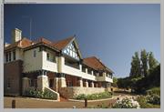
18 Yallingup Beach Rd Yallingup
Caves House Yallingup
Yallingup Caves Accommodation House
Busselton
South West
Constructed from 1905 to 1980
| Type | Status | Date | Documents |
|---|---|---|---|
| Heritage List | YES | 13 Aug 2014 | |
| State Register | Registered | 05 Jan 2001 | HCWebsite.Listing+ListingDocument, HCWebsite.Listing+ListingDocument |
| Type | Status | Date | Documents |
|---|---|---|---|
| (no listings) |
| Type | Status | Date | Grading/Management | |
|---|---|---|---|---|
| Category | ||||
| Aboriginal Heritage Sites Register | Interim | |||
| Art Deco Significant Bldg Survey | Completed | 30 Jun 1994 | ||
| Classified by the National Trust | Classified | 07 Sep 1993 | ||
| Municipal Inventory | Adopted | 20 Jun 1996 | Category 1 | |
05377 Yallingup Precinct Area; Caves, Caves House, Store, Hall, Power House and Farm
The place is in good condition.
| Name | Type | Year From | Year To |
|---|---|---|---|
| A M Campbell - Power Hse | Architect | - | - |
| A E Clare & S B Cann | Architect | - | - |
| Library Id | Title | Medium | Year Of Publication |
|---|---|---|---|
| 5780 | Proposed Strata Subdivision : Loc. 5115 Yallingup Beach Road, Yallingup. | Report | 2002 |
| 5219 | Caves House drawings : supporting development application and development guide plan / CMP Architects. | C D Rom | 2001 |
| 6979 | Caves House Yallingup : archival record. | Archival Record | 2004 |
| 5522 | Caves House, Yallingup : proposed expansion and redevelopment. | Report | 2001 |
| 7451 | House Lot 1, Caves Ridge, Yallingup : archival report. | Heritage Study {Other} | 2004 |
| 4141 | Caves House : Yallingup WA : conservation plan. | Heritage Study {Cons'n Plan} | 1996 |
| 5946 | The ridge development application : drawings. | C D Rom | 2002 |
Individual Building or Group
| Epoch | General | Specific |
|---|---|---|
| Present Use | COMMERCIAL | Hotel, Tavern or Inn |
| Original Use | COMMERCIAL | Hotel, Tavern or Inn |
| Style |
|---|
| Federation Bungalow |
| Inter-War Old English |
| Federation Filigree |
| Type | General | Specific |
|---|---|---|
| Wall | TIMBER | Weatherboard |
| Roof | METAL | Corrugated Iron |
| Wall | BRICK | Common Brick |
| General | Specific |
|---|---|
| OCCUPATIONS | Hospitality industry & tourism |
| SOCIAL & CIVIC ACTIVITIES | Sport, recreation & entertainment |
This information is provided voluntarily as a public service. The information provided is made available in good faith and is derived from sources believed to be reliable and accurate. However, the information is provided solely on the basis that readers will be responsible for making their own assessment of the matters discussed herein and are advised to verify all relevant representations, statements and information.
ARCHITECTURAL/TECHNICAL ACCOMPLISHMENT The building complex is a fine example of Western Australian Inter-war style with a fine Art Deco interior, most significant as an emission from the Public Works department. DEMONSTRATION AS A WAY OF LIFE, CUSTOM, PROCESS OR FUNCTION The dimension of this hotel complex devised for the comprehensive holiday including inter alia outdoor activities, swimming, tennis, cave exploration. Today’s patronage, the tourist industry draws from a much wider and more mobile catchment. Many visitors came to see the caves and as a result, used Caves House as a centre to visit the local beauty spots. This encompasses a way of life for people in all walks of life in WA. HISTORICAL SIGNIFICANCE OF DEVELOPMENT OF CULTURAL PHASES, ASSOCIATION WITH IMPORTANT FIGURES. Of interest is the government’s role in the industry, including continued support through the loss making years to develop the area. ENVIRONMENTAL IMPORTANCE; TOWNSCAPE OR LANDSCAPE VALUE; HIGH DEGREE OF UNITY OF SETTING The development of the site was comprehensive from the outset and part of the holdiday was seen as enjoyment of the grounds. Accordingly the melding of building and setting have long been considered an important asset to the state. The choice of site for the tourist was inspired by the beauty of the area. The verandahs of Caves House overlook 10 acres of landscaped terraced gardens, with vistas to the Indian Ocean beyond. This enhances the setting and demonstrates the importance of setting aside large reserves for the protection of natural flora. In addition, Caves House is enhanced by these terraced lawns and gardens which are not detrimental to the natural surroundings. The Caves House demonstrates important landscapes values in the vista. In addition it shows unity of materials in the use of local limestone which is consistent with the surrounding site. The scale of the building in this context is consistent with the surrounding countryside. SCIENTIFIC/ARCHEOLOGICAL IMPORTANCE The worldwide scientific interest in caves generally demonstrates the importance of the whole site, together with the local caves. The building was seen as part of the caving holiday experience. EDUCATIONAL/RESEARCH VALUE The worldwide scientific interest in caves generally demonstrates the importance of the whole site, together with the local caves. The building was seen as part of the caving holiday experience. SOCIAL SIGNIFICANCE Over the whole life of the hotel, many thousands of people have holidayed or honeymooned at Caves House Hotel. It is not uncommon nowadays for some couples whose parents, and in some cases grandparents, to begin their married life on the hotel. The fact that honeymooning couples from all walks of life, and spanning many generations have stayed at the hotel. Demonstrates the significance of Caves House. A “Back to Caves House” weekend has now become and institution and the management have instigated a scrapbook which contains photographs of honeymooners etc who have stayed there. In Western Australia, Caves House has provided a perfect venue for the honeymooning couple for almost a century. Furthermore the hotel has become a popular spot for both family holidays and tourists and as such demonstrates a strong social significance. Most families in Western Australia would have had some contact, one way or another, with Caves House. SCARCITY VALUE; A PARTICULARLY FINE OR UNIQUE EXAMPLE Caves House is a particularly fine example from a group of dispersed State owned hotel complexes. The financial support in the establishment phase was seen as a government responsibility. Other extant examples dating from the 1930’s in the South West include Yanchep National Park and to a smaller extent John Forrest National Park.
The hotel is situated in the midst of two and a half thousand acres of A class reserve, set aside for the protection of caves and flora. This reserve abounds in wildlife and through the spring and early summer over 600 varieties of wildflowers have been identified as thriving in this area. The choice of the site, half a mile from the sea, was inspired by the surrounding environment which was “set by a jewel in a narrow valley, which is itself a collapsed cave” The present Caves House is surrounded by three acres of lawn and gardens and a “far cry from the old framed Caves House”. Caves House combines local limestone, brick and timber, blending to produce a unique Tudor-style façade, common in Western Australia at the end of the 1930’s. A common feature of the Tudor style structure here was the steep pitched-tiled roof with feature gable. This was an influence of the Arts & Crafts Movement and was the antithesis of the Art Deco style which was considered the height of modernism at the time. Caves House, like many other structures built in the 1930’s in WA, comprised many of these conflicting elements. For instance, the rustic, homely entrance complements rather than belies some of the moderne fixtures which are found throughout the interior of the building. Here a dichotomy of styles is cleverly brought together by the use of seme-indirect lighting and impressing jarrah fittings. This is evident in the spacious foyer and large banquet hall. As an example, the heavy coffered ceiling, a Victorian concept and certainly necessary here because of the sheer size of the room, finds its counterpart I the dominant pylon-styled curved fireplace. This is decorated with a small plaque featuring the popular Mayan flower and enhanced by huge mirror overhead, stencilled with a South West scene of karri trees, a yacht and the rising sun. This combination of international symbols, together with those typically found in WA is again seen in the games room, where geometric plaster motifs decorate the ceiling and local game fishing motifs are featured in plaques and sandblasted in the mirror. International symbols are again found in the adjoining cocktail bar, where a large curved jarrah and chrome bar combines with a rounded treatment on door jambs to resemble naval architecture. In the former smoking room the mirror features a female kangaroo from the period diving into a quiet pool. Upstairs in the honeymoon suite the indigenous kangaroo paw enriches a curved fireplace which is typical of the period. The ocean liner influence (Nautical Moderne) is seen again in the magnificent jarrah and chrome staircase which leads to the first floor. This impressive staircase is well lit by a huge casement window facing east, whilst under the staircase sits and original jarrah-built telephone box for the use of patrons.
Assessment 1993 In 1898 Messrs. Curtis, Seymour and Dawson of Yallingup discovered what are now the world famous Yallingup caves. At this time world-wide interest in underground beauties of limestone caverns and explorations were made in many countries. Also at this time Grace Bussel, heroine of the courageous “Georgette” rescue at Margaret River, explored the very beautiful Lake Cave at Margaret River. Bussell was also associated with the Busselton and Yallingup area. After the discovery of the caves, representations were made to the Government of the day to open and develop the caves to the public. The government decided to proceed and also to build a modern hotel at Yallingup to accommodate local overseas sightseers. A Caves Board was formed and by 1920 thirteen caves were opened and stepped for exhibition to the public. Originally visitors travelled to Busselton by train and were staged in covered drays to Yallingup each day. The old stage hut still exists in a dilapidated state. The drays were later replaced by Bignells omnibuses. The original building was opened in 1904 when a wayside licence was granted and staff quarters, Caves guides cottage, a tuck shop and engine room were also built. In 1906 a Liquor Licence was granted and in 1912, a further thirty rooms were built, providing the present annexe (or bungalow). New bathrooms were attached in 1921 and the gardens expanded over the intervening years. In 1935 the original building was destroyed by fire. Retired members of the Busselton Voluntary Fire Brigade claimed that ”by a mighty effort the saved the bar”. (Part of the 1904 Caves Hotel is still extant. In recent years, additions have been made to bring it up to present-day hotel standards. Soon after this time the Government decided to build a new Caves House nd Mr W.H. Kitson, MLA Chief Secretary, took a keen interest in the project and on 21 May 1938 laid a foundation stone for the building. The building of the new hotel was carried out by R Donald and Son. Mr Donald was a nephew of the builder of the first Caves House. The timber used in the hotel and the joinery was cut and machined in Donald’s workshop, about three miles from the site. Before 1957, under the control of the State Hotels Department, the Caves house Hotel had always operated at a loss. However as a tourist attraction, with so few tourist features at the time, it is not possible to assess the effect it has had on the tourist industry. I 1957 the State Government decided to dispose of the State Hotels and this was done with the exception of Caves House and Yanchep Inn, both of which were built on A Class Reserves, requiring an enabling Act to be passed by Parliament. Both premises were leased at that time. In 1960 a 7 year lease was taken by a Mr & Mrs Copley. This was effected, through the Chief Secretary and not the Minister for Tourism. As a point of interest, no time during the lease did a Minister for Tourism visit the hotel. Up to that time, bookings and publicity were handled by the Government Tourist Bureau. The Copleys built a road from Yallingup Beach (to replace the old footpath), a three rink Bowling green, a Bear garden, they replaced existing E.C. toilets in the caravan park with a septic system , provided showers there and at the beach, almost rebuilt the tuckshop and generally raised the standard of the area. At this time the Yallingup Cave was greatly improved with an early bottleneck called Harney’s Pinch blasted out and stepped. Despite the introduction of many improvements at the expense of the owners to both Caves House and gardens and the nearby caves (with a profit to the State Government) Mr & Mrs Copley decided to relinquish the lease of the hotel. In 1965 and enabling bill was introduced to Parliament to dispose of 10 acres of the A class reserve. After a bitter debate, the bill was passed through both houses and instructions were given to a firm of hotel brokers (Dennis Hawcroft) to dispose of the premises by tender, with no reserve.
This information is provided voluntarily as a public service. The information provided is made available in good faith and is derived from sources believed to be reliable and accurate. However, the information is provided solely on the basis that readers will be responsible for making their own assessment of the matters discussed herein and are advised to verify all relevant representations, statements and information.
Constructed from 1905, Constructed from 1980
Caves House Group, a collection of buildings comprising two timber-framed main buildings constructed in 1912 in the Federation Filigree and Federation Bungalow styles respectively, and the hotel constructed of brick and tile in1938-39 in the Inter-War Old English style, together with a range of supporting function buildings, set in a culturally modified landscape, has cultural heritage significance for the following reasons: The hotel of 1938-39 is a very fine and substantial example of the Inter-War Old English style, designed and executed to high standards internally and externally, and was an outstanding achievement in the Inter-War period, when the Public Works Department of Western Australia was responsible for a number of fine buildings. The use of the Inter-War Art Deco style for the interior is unexpected. The garden setting of Caves House Group is an exceptionally fine example of an Edwardian terraced garden. With its diverse collection of buildings, cultural landscape and surrounding bushland it is a significant cultural environment. As a health resort, a holiday and honeymoon destination, and in association with the experience of visiting Yallingup Cave, the place has been highly valued by visitors since the early twentieth century, and it has become a cultural icon. Owned and developed by the Government of Western Australia from 1902 to 1968, to provide accommodation for visitors to the Yallingup Cave, the development of the place as a resort is one of the earliest and longest enduring examples of the State's ownership and development of a place as a tourist destination. Since the construction of the Accommodation House in 1902-03, together with the Yallingup Cave, the place has played a central role in the development of the Yallingup and Busselton area, of the South-West, and of the State as a tourist and holiday destination. Builder Robert Donald of Busselton was responsible for the first and last major buildings at the place, as Hough & Donald in the former, and R. Donald & Son in the latter, as well as the 1905 additions. Principal Government Architect A. E. Clare was responsible for the design of the new hotel in 1938, together with S. B. Cann.
A group of two Federation Filigree Bungalow style buildings set adjacent to an Inter - War Old English style hotel. The group of buildings sit next to carefully executed Edwardian terraced landscaped gardens. Description Notes: A cluster of buildings comprising two timber-framed main buildings built in the Federation Filigree and Federation Bungalow styles respectively. The hotel, a two storey hipped roof building with a verandah at both levels is elegantly done in Inter-War Old English style; using brick and tile construction. The innovative use of Inter-War Art Deco style for the interior sets it apart from its counterparts. The original hotel that existed on the site burnt down in 1935. Adjoining the building is an Edwardian terraced landscaped garden. The clever merging of Man and Nature is apparent in the manner that the garden was set harmoniously with the dramatic natural landscape. High/High
The Government of Western Australia built the first Caves House in 1902-03, to provide accommodation for visitors to the newly discovered Yallingup Cave, and the Government continued to develop and administer the place to 1968. Caves House Group may be compared to the development of a similar facility also promoted by the Caves Board at Yanchep, where similar notions of accommodation, caves and leisure were realised. Caves House Group was one of the earliest and longest enduring examples of the State's ownership and development of a place as a tourist destination. Caves House Group featured prominently in the promotion of tourism in Western Australia by the Tourist and Information Bureau in the first half of the twentieth century, and has continued to be a focal point for tourism through the latter half of the twentieth and into the twenty- first century. The first development at the Caves House Group, Yallingup Cave Accommodation House, was built by Hough & Donald in 1902-03; with additions comprising tennis courts and billiard room built by Robert Donald in 1905; and the new hotel (1938-39) was built by R. Donald & Son. Thus Robert Donald was responsible for the first and last major buildings at the place. Principal Government Architect A. E. Clare was responsible for the design of new hotel (1938-39). Clare was assisted by S. B. Cann, who later became Principal Architect. The new hotel (1938-39) is a very fine and substantial example of the Inter-War Old English style, designed and executed to high standards internally and externally, and was an outstanding achievement in the Inter-War period, when the Public Works Department of Western Australia was responsible for a number of fine buildings.
Integrity Notes: The place retains a high degree of integrity, with the exception of the Summer House beside the power house and two garden sheds in the main grounds below the hotel, garden sheds are ephemeral and are considered to have low significance. The beer garden bar, concrete unit pavings, and present treatment of the main driveway in front of the hotel are considered intrusive. Authenticity Notes: The place retains a high degree of authenticity. High Degree/High Degree
Good
| Ref ID No | Ref Name | Ref Source | Ref Date |
|---|---|---|---|
| Caves House, Yallingup: "Archival Record, Heritage Study" | 2004 | ||
| Caves House, Yallingup WA: "Conservation Heritage Study" | 1996 | ||
| The Ridge Development Application:"Drawings" | CD Rom | 2001 | |
| Caves House, Yallingup: "Proposed Expansion and Redevelopment Report" | 2001 | ||
| CMP Architects; Caves House Drawings: "Supporting development application and development guide plan". | CD Rom | 2001 | |
| Proposed Strata Subdivision:"Loc 5115 Report, Yallingup Beach Road Yallingup" | 2002 | ||
| Caves House Plans | 2002 | ||
| Caves House Plans | 2001 |
| Owner | Category |
|---|---|
| Yallingup Ridge Pty Ltd | Other Private |
This information is provided voluntarily as a public service. The information provided is made available in good faith and is derived from sources believed to be reliable and accurate. However, the information is provided solely on the basis that readers will be responsible for making their own assessment of the matters discussed herein and are advised to verify all relevant representations, statements and information.