Local Government
Canning
Region
Metropolitan
1317 Albany Hwy Cannington
Lot 3 on Plan 2936
Canning
Metropolitan
Constructed from 1987, Constructed from 1971
| Type | Status | Date | Documents |
|---|---|---|---|
| Heritage List | Adopted | 18 Sep 2018 |
| Type | Status | Date | Documents |
|---|---|---|---|
| (no listings) |
| Type | Status | Date | Grading/Management | |
|---|---|---|---|---|
| Category | ||||
| Municipal Inventory | Adopted | 08 Aug 1995 | 3 | |
| Municipal Inventory | Adopted | 17 Oct 2017 | 3 | |
| Name | Type | Year From | Year To |
|---|---|---|---|
| Hobbs Winning & Leighton | Architect | - | - |
Individual Building or Group
| Epoch | General | Specific |
|---|---|---|
| Present Use | GOVERNMENTAL | Office or Administration Bldg |
| Original Use | GOVERNMENTAL | Office or Administration Bldg |
| Type | General | Specific |
|---|---|---|
| Roof | TILE | Ceramic Tile |
| Wall | BRICK | Common Brick |
| Other | CONCRETE | Pre-cast concrete panel |
| General | Specific |
|---|---|
| SOCIAL & CIVIC ACTIVITIES | Government & politics |
This information is provided voluntarily as a public service. The information provided is made available in good faith and is derived from sources believed to be reliable and accurate. However, the information is provided solely on the basis that readers will be responsible for making their own assessment of the matters discussed herein and are advised to verify all relevant representations, statements and information.
Constructed from 2005 to 2006, Constructed from 1987, Constructed from 1971
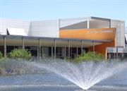
The Canning City Council Administration Centre, a two storey building, which contains both civic and administration functions has cultural heritage significance for the following reasons: the place is valued by the local community as the seat of local government responsible for administration of local affairs since 1971; the buildings and the site are an example of Twenty-first Century planning and architecture in Perth and the integration between the buildings and the landscape design of high quality; and the evolution of the site since its original acquisition illustrate the development of key civic facilities as the population grows and the needs of the community change. The buildings and the site are significant as an example of 1970s modem planning and architecture in Perth and the integration between the buildings and the landscape design of the site is of particular significance. Together the buildings and site provide a significant example of the influence of the Modern Movement on architecture in Western Australia.
The subject place forms part of a Civic Centre precinct containing the historic former Town Hall, lakes and parklands surrounding the Administration building. North of the building the landscape interprets the former Wilson and John Nursery, which was once located on the site, in the rows of plantings. To the rear of the building the landscape is less formal with child play areas, barbecue facilities and an amphitheatre bowl to stage civic concerts and events. The main entrance for the building is from the north, however the foyer is double fronted to address the ponds and landscaped areas to the south. The building is largely horizontal in nature with the Administration located within the single storey component and the Civic areas in a two-storey component. However, the administration area has a double height entrance foyer. This foyer is protected by a large over-sailing canopy to the north. The windows at the upper floor level are screened by a combination of perforated screens and verandah roofs.
HISTORICAL INFORMATION During the 1950s and 60s expansion of the Canning district led to the need for increased accommodation for the administration of the Shire, which had been contained within the Town Hall, located at 1309 Albany Highway, Cannington. In 1963 the Council purchased 17.75 acres of land adjoining the Town Hall for the purpose of constructing a new Administration Centre. The land formed part of the Wilson and John's nursery and contained an old homestead known as 'Kaliamba'. The design of the proposed Administration Centre was the subject of an architectural competition based on construction of the centre in two stages with the council chamber, committee rooms and administration offices forming stage one, followed by the construction of a town hall, lesser hall, welfare centre and clinic in stage two. The winning design was submitted by architects Hobbs, Winning and Leighton and the assessment report on the design noted the appropriateness of the planning of the buildings to meet the needs of both Council and the administrative staff and the potential for attractive landscaping of the site despite its lack of natural features. The landscaping of the site included the creation of several artificial lakes, designed by Jean Verschuer who was prominent in the field of landscape design in Perth at the period. The Administration Centre was opened on 2nd May 1971 by the Hon. R.H.C. Stubbs M.L.C Minister for Local Government. The second stage of the complex was never completed however an entry foyer was added in 1987. The design of the Council buildings consisted of a series of tiled pavilions grouped together with internal courtyards and set in an open landscaped area. Administrative departments were grouped together around a public foyer and Council rooms were grouped around a reception hall. Both the planning of the complex and the design of the buildings were typical examples of architecture of the 1960s and 70s and showed influence of the Modern Movement in the horizontal emphasis of the buildings expressed in the columns and facias which dominated the facades of the administrative buildings and the public entrance. At the turn of the Twenty-first Century it became apparent that the City had outgrown the 1971 Hobbs, Winning and Leighton building and sought to construct a larger, energy efficient building with capacity to expand. The new facility is located just north of the earlier building (now demolished) and forms part of a Civic Centre precinct containing the historic former Town Hall and lakes and parklands surrounding the new building Opened in 2006, and designed by Jones Coulter Young (JCY) Architects who also did the masterplanning, contract documentation, contract administration and interior design. The new building cost $12.3 million dollars and won the RAIA Award for Public Architecture (WA) in 2007 and a Mondo Luce Lighting Award in the same year. JCY describe the building as ‘contemporary, elegant and is embued with a Civic presence that is neither extravagant nor ostentatious.’ A significant number of workstations, partitions and chairs from the original building were recycled into the new building..
High
Good: well maintained
| Name | Type | Year From | Year To |
|---|---|---|---|
| Hobbs Winning and Leighton | Architect | 1971 | - |
| Jones Coulter Young | Architect | 2005 | - |
| Ref ID No | Ref Name | Ref Source | Ref Date |
|---|---|---|---|
| D Hickson; "Canning Centenary 1871 - 1971". | 1971 | ||
| Municipal Heritage Inventory | City of Canning | 2017 | |
| "Town of Canning Official Opening Administration Building". | 1971 |
| Reserve | Lot/Location | Plan/Diagram | Vol/Folio |
|---|---|---|---|
| 3 | 2936 | 2150/627 |
| Owner | Category |
|---|---|
| City of Canning | Local Gov't |
This information is provided voluntarily as a public service. The information provided is made available in good faith and is derived from sources believed to be reliable and accurate. However, the information is provided solely on the basis that readers will be responsible for making their own assessment of the matters discussed herein and are advised to verify all relevant representations, statements and information.
1325 Albany Hwy Cannington
Canning
Metropolitan
Constructed from 1998
| Type | Status | Date | Documents |
|---|---|---|---|
| (no listings) |
| Type | Status | Date | Documents |
|---|---|---|---|
| RHP - Does not warrant assessment | Current | 28 Sep 2012 |
| Type | Status | Date | Grading/Management | |
|---|---|---|---|---|
| Category | ||||
| (no listings) | ||||
Excellent
Individual Building or Group
| Epoch | General | Specific |
|---|---|---|
| Other Use | GOVERNMENTAL | Police Station or Quarters |
| General | Specific |
|---|---|
| SOCIAL & CIVIC ACTIVITIES | Law & order |
This information is provided voluntarily as a public service. The information provided is made available in good faith and is derived from sources believed to be reliable and accurate. However, the information is provided solely on the basis that readers will be responsible for making their own assessment of the matters discussed herein and are advised to verify all relevant representations, statements and information.
1348 Albany Hwy Cannington
Lot 1 on Plan 36936
Boans Waverley
Cannington Shopping Centre
Carousel Regional Shopping Town
Westfield Carousel
Canning
Metropolitan
| Type | Status | Date | Documents |
|---|---|---|---|
| (no listings) |
| Type | Status | Date | Documents |
|---|---|---|---|
| (no listings) |
| Type | Status | Date | Grading/Management | |
|---|---|---|---|---|
| Category | ||||
| Municipal Inventory | Adopted | 17 Oct 2017 | 4 | |
Individual Building or Group
| Epoch | General | Specific |
|---|---|---|
| Original Use | COMMERCIAL | Shopping Complex |
| Style |
|---|
| Late 20th-Century Late Modern |
| Type | General | Specific |
|---|---|---|
| Roof | CONCRETE | Concrete Slab |
| General | Specific |
|---|---|
| SOCIAL & CIVIC ACTIVITIES | Community services & utilities |
This information is provided voluntarily as a public service. The information provided is made available in good faith and is derived from sources believed to be reliable and accurate. However, the information is provided solely on the basis that readers will be responsible for making their own assessment of the matters discussed herein and are advised to verify all relevant representations, statements and information.
Constructed from 1972, Constructed from 2017, Constructed from 1978, Constructed from 1958, Constructed from 1999 to 2000, Constructed from 2008
Carousel Shopping Centre is significant for the association with the rapid development of Cannington and its surrounding suburbs, and is reputedly the first enclosed mall shopping centre in Western Australia.
Westfield Carousel Shopping Centre is the largest land holding within the Canning City Centre and has been a prominent landmark as the largest shopping destination in the southeast metropolitan corridor. The place comprises a fully enclosed two-storey painted precast concrete walls with contemporary cladding panels, and concrete floor with epoxy coating concrete roof throughout. As of January 2017, the place comprises 290 tenancies and 82,275m² of gross lettable area.
According to a 1906 estate plan of the ‘Federal Estate’, the site of Carousel Shopping Centre once contained the Road Board Office building, Cannington Primary School, Hotel Cecil, and residential development. In addition, a post office was also located opposite the Main Perth-Albany Road (now Albany Highway), which suggests that at the time, the site of Carousel Shopping Centre was a central place for the local community. A 1953 historical aerial photograph of the site of Carousel Shopping Centre indicates that the site remained largely vacant retained the Road Boards Office building (whose function had moved to the local Town Hall in 1909), Cannington Primary School, Hotel Cecil, and residential development to the northeast and to the southwest. By the late 1950’s, the Road Boards Office building was demolished to make way for a new shopping centre. On 25 September, 1958, the Boans Waverley Store opened between the Hotel Cecil and Cannington Primary School. The Boans Waverly Store was Cannington’s first large shopping centre, constructed of concrete, brick and glazing which was representative of the Late Twentieth-Century Late Modern style of commercial buildings. At this time, there were few shopping centres in Perth and most people would go into the City to shop. Boans Waverly attracted much public attention prior to its opening and people crowded into the store. Yoyos were popular during this time and the Boans store received a display from the Coca Cola yoyo team with organised competitions for children. The store also had a confectionary counter with lengths of sugar cane, which attracted much excitement from children, especially the students of Cannington Primary School as their school was located adjacent to the store. Boans Waverley contained a cafeteria with a variety of food displays with hot chips being the most popular. Men, women and children clothing, makeup counters and household goods and vinyl records were available within the store. A fenced playground was located to the back of the store which had a pumpkin shaped slide. Boans later provided holiday employment for many residents and supplied the entire Canning area as well as others from surrounding suburbs. As a result of its success, 64 additional stores were built as part of an extension and redevelopment which subsequently formed the Cannington Regional Shopping Centre. The State Premiere at the time, Mr. J. Tonkin M.P, officially marked the opening of the $8 million redevelopment with a grand fireworks display. The Boans store became part of the larger centre which claimed to be the first fully enclosed air-conditioned shopping centre in the state. Cannington Regional Shopping Centre contained a Woolworths supermarket, Boans (which later became Myers), and Aherns (which later became David Jones) and Walsh’s. To make way for the extension, Cannington Primary School as well as several houses were demolished and relocated. As part of the works, the original façade of the Boans store was also replaced with red metallic cladding which was installed around the rest of the shopping centre. By 1973, a stand-alone Target department store was constructed over a vacant site to the north and in 1979, another extension was built to connected the Target store, a Coles supermarkets and other specialty stores with the rest of the centre. On 28 June 1990, a standalone cinema complex was also constructed along Cecil Avenue to the rear of the shopping centre. From 1998 to 1999, the centre was extensively redeveloped and the retail area expanded to about twice its original size to become the largest shopping centre in Western Australia. As part of the redevelopment, the stand-alone cinema to the rear was demolished and relocated inside the shopping centre. The majority of the façade to the shopping centre was removed, apart from the former Walsh’s façade which contained a series of window awnings. Further tenancy reconfigurations were completed in 2000 and in 2008 a second storey gym tenancy and other specialty stores and banks where completed. In early 2017, construction commenced on the first stage of Westfield Carousel’s redevelopment which will include the re-introduction of a David Jones store and more than 60 new stores, a multi-deck carpark, an open-air lifestyle and leisure precinct, a refurbished 14-screen cinema and 12 new restaurants. The expansion will provide an additional 47,108m2 of floorspace, enlarging the Centre to 130,230m2. Most of the original fabric, including the original awnings, was removed as part of the scope of works. This work was completed by September 2018 when the expanded facilities opened.
Low
Good
| Ref ID No | Ref Name | Ref Source | Ref Date |
|---|---|---|---|
| City of Canning Municipal Heritage Inventory | City of Canning | October 2017 |
| Reserve | Lot/Location | Plan/Diagram | Vol/Folio |
|---|---|---|---|
| 1 | P36936 | 2690/90 |
This information is provided voluntarily as a public service. The information provided is made available in good faith and is derived from sources believed to be reliable and accurate. However, the information is provided solely on the basis that readers will be responsible for making their own assessment of the matters discussed herein and are advised to verify all relevant representations, statements and information.
1363 Albany Hwy Cannington
Canning
Metropolitan
Constructed from 1950
| Type | Status | Date | Documents |
|---|---|---|---|
| (no listings) |
| Type | Status | Date | Documents |
|---|---|---|---|
| (no listings) |
| Type | Status | Date | Grading/Management | |
|---|---|---|---|---|
| Category | ||||
| Municipal Inventory | Adopted | 08 Aug 1995 | 3 | |
Individual Building or Group
| Epoch | General | Specific |
|---|---|---|
| Other Use | RESIDENTIAL | Single storey residence |
| Present Use | COMMERCIAL | Shop\Retail Store {single} |
| Original Use | COMMERCIAL | Shop\Retail Store {single} |
| Other Use | COMMERCIAL | Warehouse |
| Type | General | Specific |
|---|---|---|
| Wall | BRICK | Common Brick |
| General | Specific |
|---|---|
| OCCUPATIONS | Commercial & service industries |
This information is provided voluntarily as a public service. The information provided is made available in good faith and is derived from sources believed to be reliable and accurate. However, the information is provided solely on the basis that readers will be responsible for making their own assessment of the matters discussed herein and are advised to verify all relevant representations, statements and information.
Local significance relating to the early settlement of the Canning area.
Complex of buildings including a brick warehouse building facing Greenfield Street behind a 1950s style shop front with black glazed tiles to the front elevation, original shop front windows and an unusual stylised entry door. Both probably built circa 1950. The existing buildings replace an earlier building on the site. The site also includes a house probably also circa 1950, tennis court, rose garden and a garage with Marseille profile clay roof tiles, probably built circa the 1920s.
This information is provided voluntarily as a public service. The information provided is made available in good faith and is derived from sources believed to be reliable and accurate. However, the information is provided solely on the basis that readers will be responsible for making their own assessment of the matters discussed herein and are advised to verify all relevant representations, statements and information.
1429-33 Albany Hwy Cannington
Canning
Metropolitan
Constructed from 1945
| Type | Status | Date | Documents |
|---|---|---|---|
| (no listings) |
| Type | Status | Date | Documents |
|---|---|---|---|
| (no listings) |
| Type | Status | Date | Grading/Management | |
|---|---|---|---|---|
| Category | ||||
| Municipal Inventory | Adopted | 08 Aug 1995 | 3 | |
Individual Building or Group
| Epoch | General | Specific |
|---|---|---|
| Present Use | COMMERCIAL | Shop\Retail Store {single} |
| Original Use | COMMERCIAL | Shop\Retail Store {single} |
| General | Specific |
|---|---|
| OCCUPATIONS | Commercial & service industries |
This information is provided voluntarily as a public service. The information provided is made available in good faith and is derived from sources believed to be reliable and accurate. However, the information is provided solely on the basis that readers will be responsible for making their own assessment of the matters discussed herein and are advised to verify all relevant representations, statements and information.
Constructed from 1945
Local significance relating to the settlement of the Canning area.
Shops built circa 1945. Shop on corner demolished c1984 and other shop demolished c2000
This information is provided voluntarily as a public service. The information provided is made available in good faith and is derived from sources believed to be reliable and accurate. However, the information is provided solely on the basis that readers will be responsible for making their own assessment of the matters discussed herein and are advised to verify all relevant representations, statements and information.
1430 Albany Hwy Cannington
Canning
Metropolitan
| Type | Status | Date | Documents |
|---|---|---|---|
| (no listings) |
| Type | Status | Date | Documents |
|---|---|---|---|
| (no listings) |
| Type | Status | Date | Grading/Management | |
|---|---|---|---|---|
| Category | ||||
| (no listings) | ||||
| Library Id | Title | Medium | Year Of Publication |
|---|---|---|---|
| 3781 | Canning Agricultural Hall 1909-1995 | Heritage Study {Other} | 1998 |
Individual Building or Group
| Epoch | General | Specific |
|---|---|---|
| Present Use | SOCIAL\RECREATIONAL | Agricultural Hall |
| Original Use | SOCIAL\RECREATIONAL | Agricultural Hall |
This information is provided voluntarily as a public service. The information provided is made available in good faith and is derived from sources believed to be reliable and accurate. However, the information is provided solely on the basis that readers will be responsible for making their own assessment of the matters discussed herein and are advised to verify all relevant representations, statements and information.
1455 Albany Hwy Cannington
Canning
Metropolitan
Constructed from 1912
| Type | Status | Date | Documents |
|---|---|---|---|
| (no listings) |
| Type | Status | Date | Documents |
|---|---|---|---|
| (no listings) |
| Type | Status | Date | Grading/Management | |
|---|---|---|---|---|
| Category | ||||
| Municipal Inventory | Adopted | 08 Aug 1995 | 4 | |
Individual Building or Group
| Epoch | General | Specific |
|---|---|---|
| Original Use | RELIGIOUS | Church, Cathedral or Chapel |
| Present Use | RELIGIOUS | Church, Cathedral or Chapel |
| Type | General | Specific |
|---|---|---|
| Wall | TIMBER | Weatherboard |
| Roof | METAL | Corrugated Iron |
| General | Specific |
|---|---|
| SOCIAL & CIVIC ACTIVITIES | Religion |
This information is provided voluntarily as a public service. The information provided is made available in good faith and is derived from sources believed to be reliable and accurate. However, the information is provided solely on the basis that readers will be responsible for making their own assessment of the matters discussed herein and are advised to verify all relevant representations, statements and information.
Constructed from 1912
Of local significance representing the early development of the Canning area. Also significant to the history of the Methodist (Uniting) Church in the State.
Timber framed, weatherboard and iron church building constructed in 1912.
The Methodist Church was established in the Canning District in the early 1900s and from around 1907 held services in the Agricultural Hall. The small timber framed church on Albany Highway with its attached meetings room was used until a new church was constructed in 1963.
| Ref ID No | Ref Name | Ref Source | Ref Date |
|---|---|---|---|
| FG Carden; "Along the Canning". p 105 | 1991 |
| Owner | Category |
|---|---|
| uUniting Church in Australia | Church Property |
This information is provided voluntarily as a public service. The information provided is made available in good faith and is derived from sources believed to be reliable and accurate. However, the information is provided solely on the basis that readers will be responsible for making their own assessment of the matters discussed herein and are advised to verify all relevant representations, statements and information.
Cnr Albany Hwy & Manning Rd Cannington
Lot 4013, Plan P192402
WW1 & WW2
Canning
Metropolitan
Constructed from 1921 to 1956
| Type | Status | Date | Documents |
|---|---|---|---|
| Heritage List | Adopted | 18 Sep 2018 | |
| State Register | Registered | 23 May 1997 | HCWebsite.Listing+ListingDocument, HCWebsite.Listing+ListingDocument |
| Type | Status | Date | Documents |
|---|---|---|---|
| (no listings) |
| Type | Status | Date | Grading/Management | |
|---|---|---|---|---|
| Category | ||||
| Statewide War Memorial Survey | Completed | 01 May 1996 | ||
| Classified by the National Trust | Classified {HBS} | |||
| Municipal Inventory | Adopted | 17 Oct 2017 | 1 | |
| Municipal Inventory | Adopted | 08 Aug 1995 | 1 | |
| Library Id | Title | Medium | Year Of Publication |
|---|---|---|---|
| 6606 | Register of historic burial sites as at June 1988. | Report | 1988 |
Other Built Type
| Epoch | General | Specific |
|---|---|---|
| Original Use | MONUMENT\CEMETERY | Monument |
| Present Use | MONUMENT\CEMETERY | Monument |
| Style |
|---|
| Other Style |
| Type | General | Specific |
|---|---|---|
| Other | STONE | Marble |
| Wall | STONE | Donnybrook Sandstone |
| General | Specific |
|---|---|
| OUTSIDE INFLUENCES | World Wars & other wars |
This information is provided voluntarily as a public service. The information provided is made available in good faith and is derived from sources believed to be reliable and accurate. However, the information is provided solely on the basis that readers will be responsible for making their own assessment of the matters discussed herein and are advised to verify all relevant representations, statements and information.
This site is dedicated to the remembrance of Canning residents who gave their lives during both Wars. Historic: A piece of Canning history Educational: Showing the new generation the loss of young lives in war. Representativeness: Magnificent construction of Donnybrook stone in the form of an Archway erected in the 1920's.
Assessment 1993 (1919) 1-9: Returned Soldiers Association wrote to Board re: erection of memorial to fallen soldiers of Canning (1919) 29-9: Committee collection information on memorials. (1920) 9-1: Public Meeting held at Town Hall (1920) Miss W. Woodhouse; Miss L. Wilson: Miss Corhey given free use of Town Hall four times for “Fallen Soldiers Memorial Fund”. (1921): Foundation stone laid on the 5 Feb 1921 by Sir Francis A. Newgate K.C.M.G. Upon its completion a plaque was attached. It bore the inscription: “This Memorial was erected by the residents of Queens Park Rds District To the memory of those soldiers of the district who fell during the War 1914 – 1919.” At that stage there were machine guns at top of the Memorial which were removed in war time, 1940. As the Town Hall was extended and used as a picture theatre, the Arch suffered minor damage from vandals. The structure lost its dignity. (1948): A Committee was formed from the Canning-Welshpool branches of the R.S.L. Also representatives of the C.R.B. The Arch was dismantled and re-erected on the corner of Albany Highway and Fremantle Road, now Manning Road. Finance for the removal was raised by donations to the “War Memorial Fund”. The erection of the Arch was undertaken by Mr H.A. Hicks (stonemason). At least two tons of car bodies plus pieces of Shephards Garage plus two tons of Australian cement were used as Reinforcement. Rose gardens and lanns finish it off. The ashes of returned service men have been placed in the area to the front of the memorial, never to be disturbed. The Memorial is now to the Fallen of two World Wars.
This information is provided voluntarily as a public service. The information provided is made available in good faith and is derived from sources believed to be reliable and accurate. However, the information is provided solely on the basis that readers will be responsible for making their own assessment of the matters discussed herein and are advised to verify all relevant representations, statements and information.
Constructed from 1921, Constructed from 1956
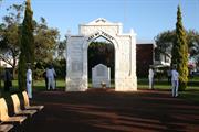
Canning War Memorial, a white painted, freestanding masonry memorial arch and matching stone panel in a formal garden setting, has cultural heritage significance for the following reasons: it is a symbol of national mourning for those who lost their lives in World Wars One and Two; the memorial is a means of identifying the men and women from the Canning district in alphabetical order; and, the place is located on a predominant point between two major roads opposite the Canning Town Hall (this present site was used for the erection of a memorial in 1956 to replace the original siting outside the Canning Town Hall from 1921. This was due to road realignment). The memorial is important at a local level in that it is the only means of identifying the men from the district who served in WWI and WWII, (officilal records are only arranged by name or service unit, rather than home town or place of enlistment). The fact that the names on the memorial are recorded in alphabetical order and are non-hierarchical in that the rank of the men is not identified, can be interpreted as symbolic of a national egalitarian and democratic ethos. The modest scale of the Canning War Memorial reflects the aspirations, size and degree of propsperity of the local community. While not outstanding for its creative or artistic achievement, the memorial was completely constructed and thoughtfully designed, both in its original form, subsequent relocation and in its later additions of new elements. The arch is not uncommon in the design of memorials and takes a variety of forms, however the design of the Canning War Memorial is probably unusual in the Western Australian context. All war memorials are both representative, because of their symbollic function and unique because of their local community associations and settings. The memorial has importance for social values; it is valued by the community in general as exemplified by the high standard of maintenance of the memorial itself adn the surrounding garden setting and by the district's RSL sub-branches. It is significant as a community shrine and the site of the traditional ANZAC Day and Armistice Day commemorative services.
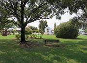
Canning War Memorial comprises a Donnybrook stone arch in a formal garden setting, on a reserve near the intersection of Manning Road and Albany Highway. The stonework is now painted white which conceals the craftsmanship of the masonry work. The two machine guns, which adorned the memorial, were removed in 1940 and were not replaced. The memorial is laid out in a symmetrical arrangement with the arch and flagpole aligned at either end of a central access with garden beds on either side. Lawn areas with crossed garden beds of roses are symmetrically placed, together with informal plantings of trees. The modest scale of the Canning War Memorial reflects the aspirations, size and degree of prosperity of the local community at the time. While not outstanding for its creative or artistic achievement, the memorial was competently constructed and thoughtfully designed, both in its original form, subsequent relocation and in the later addition of new elements. The names of men killed in action during World War One are inscribed on two marble tablets mounted on either side of the arch. In addition to the original arch, the memorial includes a matching stone panel bearing the names of the men killed in World War Two and a plaque commemorating the 75th Anniversary of Remembrance Day, 11 November 1993. A time capsule was buried behind the Arch in 2000 by the City of Canning.
From the Queen's Park district it was reported that 230 men enlisted inactive service in the great war and of that number 43 were killed on the battlefield or died of wounds or disease. In 1921, in line with similar moves by local government and community associations throughout Australia, it was decided to commemorate the sacrifice of the men who had died at war by the erection of a permanent memorial. The site for the memorial was to be outside the then Canning Town Hall. The memorial was in the form of a monumental arch, which was unveiled on Monday 25 April 1921 by the then Minister for Works (Mr W. J. George). A report in the West Australian dated, Tuesday 26 April 1921 (p.5) set out 'The arch, which is of Tudor design and composed of Donnybrook stone occupies a fine site at the corner of Albany Road and George Street, immediately in front of the local town hall, and both names of the fallen soldiers are inscribed on marble tablets as insets to the supporting columns.’ In his address the Minister for works said that only the day before he had laid the foundation stone of a monument at Gosnells, another part of the then Canning district. The Town Hall was extended for use as a venue for movies in 1926. The changing use of the place led to dissatisfaction with the site as an appropriate venue for the memorial. In 1948, after World War Two, it was felt that a more appropriate site should be found. A triangular portion of land on the corner of Albany Highway and Manning Road was purchased for that purpose by the Canning Road Board for £150. Local RSL branches undertook special drives and sought donations to raise money to relocate the structure and to beautify the parkland. The memorial arch was disassembled by local volunteers in 1956 and transferred to its present location. The move and reconstruction was overseen by local stonemason, A.H Hicks. In 1993, a plaque commemorating the 75th anniversary of Remembrance Day, 11 November, was added to Canning War Memorial is the site of local Anzac Day and Armistice Day celebrations, and the ashes of some servicemen have been buried on the site.
High. Alterations: Relocation on a new site and the addition of new features to commemorate WWII and Armistice Day, have been made in a sympathetic manner. The stonework is painted which which detracts from the appearance of the memorial and conceals the craftsmanship of the masonry work. The two machine guns were removed in 1940 and were not replaced. The honour board remained in the hall following the re-location of the memorial; its present location is within the local RS&L club building in Wharf St, Cannington. The ashes of former servicemen are buried at the memorial site.
Good: well maintained
| Ref ID No | Ref Name | Ref Source | Ref Date |
|---|---|---|---|
| National Trust of Australia assesment forms | 2/2/1993 | ||
| Index to Local Government minutes. | Riverton Local History Library | ||
| J McKay and R Allom; "Lest We Forget". | RSL of Australia Qld branch | 1984 | |
| Riverton Local History Library | |||
| FG Carden; "Along the Canning River". pp162-164 | 1991 |
| Reserve | Lot/Location | Plan/Diagram | Vol/Folio |
|---|---|---|---|
| 4013 | 192402 | LR3106-87 |
| Owner | Category |
|---|---|
| City of Canning | Local Gov't |
This information is provided voluntarily as a public service. The information provided is made available in good faith and is derived from sources believed to be reliable and accurate. However, the information is provided solely on the basis that readers will be responsible for making their own assessment of the matters discussed herein and are advised to verify all relevant representations, statements and information.
Canning River Reg Pk, Bicentennial Adenia Reserve Cannington
former Reserve 1455
Brickworks Landing
Canning
Metropolitan
Constructed from 1889
| Type | Status | Date | Documents |
|---|---|---|---|
| (no listings) |
| Type | Status | Date | Documents |
|---|---|---|---|
| (no listings) |
| Type | Status | Date | Grading/Management | |
|---|---|---|---|---|
| Category | ||||
| Municipal Inventory | Adopted | 17 Oct 2017 | 5 | |
| Municipal Inventory | Adopted | 08 Aug 1995 | 5 | |
18987 Swan and Canning Rivers
Historic Site
| Epoch | General | Specific |
|---|---|---|
| Present Use | Transport\Communications | Water: Other |
| Original Use | Transport\Communications | Water: Other |
| General | Specific |
|---|---|
| OCCUPATIONS | Timber industry |
| TRANSPORT & COMMUNICATIONS | River & sea transport |
| OCCUPATIONS | Manufacturing & processing |
This information is provided voluntarily as a public service. The information provided is made available in good faith and is derived from sources believed to be reliable and accurate. However, the information is provided solely on the basis that readers will be responsible for making their own assessment of the matters discussed herein and are advised to verify all relevant representations, statements and information.
Constructed from 1887
18987 Swan and Canning Rivers
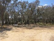
The landing has cultural heritage significance for the following reasons: It is important for historic values because of its association with the pioneering phase of settlement in the district in the late 19th century, and for its association with the firewood and brickmaking industries which were typical of the area in the colonial period. It has importance as part of the history of river transport in the colony, which enabled settlement and development to take place, before the advent of an adequate road transport network. The site has importance at a local level for its association with the recreational use of the river throughout the present century. It may have archaeological potential, which will lead· to an increased understanding of the history of the district and of river transport in general.
The extract location of the landing and remaining brickworks could not be found during the 2015 MHI Review.
The reserve, located on the left bank of the Canning River in the vicinity of The Islands, was surveyed in 1887 and 1888 and gazetted as a landing place in June 1889. The reserve incorporated two separate landing places which had been cleared by the local settlers and used on an unofficial basis for some time prior to being reserved for public use. A network of tracks and a partly made road leading to the landings, which were documented by the Lands & Survey Department surveyor, testified to their use for loading firewood and other goods, and their importance to the local residents. When a small brickworks commenced operations in the vicinity c.l896 the lower landing place was used by the brickworks for loading bricks for dispatch down the river by barge. The 1995 Municipal Heritage Inventory documentation suggested that evidence could be seen of a former timber jetty and brick rubble thought to be associated with the brickworks' use of the site. These could not be located in the 2015 review. The reserve now forms part of the Canning River Regional Park and is located within the Bicentennial Adenia Reserve.
Integrity: Low Authenticity: Low
Poor
| Ref ID No | Ref Name | Ref Source | Ref Date |
|---|---|---|---|
| Richards; "Canning River Regional Park, Western Australia: Historical Survey". pp 61, 73, 74 & 70 | Perth DPUD | 1991 | |
| Government Gazette Notices | |||
| Lands & Survey Department records and surveyor's field work. | File: 3441/86 |
| Reserve | Lot/Location | Plan/Diagram | Vol/Folio |
|---|---|---|---|
| 7773 | 921 | 240087 | 3055/958 |
| Owner | Category |
|---|---|
| State of W.A. | State Gov't |
This information is provided voluntarily as a public service. The information provided is made available in good faith and is derived from sources believed to be reliable and accurate. However, the information is provided solely on the basis that readers will be responsible for making their own assessment of the matters discussed herein and are advised to verify all relevant representations, statements and information.
Cnr Carden Dr & Oak St Cannington
Canning
Metropolitan
| Type | Status | Date | Documents |
|---|---|---|---|
| (no listings) |
| Type | Status | Date | Documents |
|---|---|---|---|
| (no listings) |
| Type | Status | Date | Grading/Management | |
|---|---|---|---|---|
| Category | ||||
| Municipal Inventory | Adopted | |||
Tree
| Epoch | General | Specific |
|---|---|---|
| Present Use | OTHER | Other |
| Original Use | OTHER | Other |
| General | Specific |
|---|---|
| DEMOGRAPHIC SETTLEMENT & MOBILITY | Settlements |
This information is provided voluntarily as a public service. The information provided is made available in good faith and is derived from sources believed to be reliable and accurate. However, the information is provided solely on the basis that readers will be responsible for making their own assessment of the matters discussed herein and are advised to verify all relevant representations, statements and information.
Local significance to the early settlement of the area.
Flooded gum with a section of post and rail fence embedded into it.
The history of the tree is not known.
This information is provided voluntarily as a public service. The information provided is made available in good faith and is derived from sources believed to be reliable and accurate. However, the information is provided solely on the basis that readers will be responsible for making their own assessment of the matters discussed herein and are advised to verify all relevant representations, statements and information.
44 George Way Cannington
House
Queens Park Fire Station (fmr)
Canning
Metropolitan
Constructed from 1913
| Type | Status | Date | Documents |
|---|---|---|---|
| Heritage List | Adopted | 18 Sep 2018 |
| Type | Status | Date | Documents |
|---|---|---|---|
| (no listings) |
| Type | Status | Date | Grading/Management | |
|---|---|---|---|---|
| Category | ||||
| Municipal Inventory | Adopted | 08 Aug 1995 | 3 | |
| Municipal Inventory | Adopted | 17 Oct 2017 | 2 | |
| Fire & Rescue Service Heritage Inventory | Adopted | 30 Aug 1997 | ||
Historic Site
| Epoch | General | Specific |
|---|---|---|
| Original Use | GOVERNMENTAL | Fire Station |
| Present Use | VACANT\UNUSED | Vacant\Unused |
| General | Specific |
|---|---|
| SOCIAL & CIVIC ACTIVITIES | Community services & utilities |
This information is provided voluntarily as a public service. The information provided is made available in good faith and is derived from sources believed to be reliable and accurate. However, the information is provided solely on the basis that readers will be responsible for making their own assessment of the matters discussed herein and are advised to verify all relevant representations, statements and information.

Constructed from 1943
The single storey brick and tile Fire Station (fmr) building has cultural heritage significance for the following reasons: It is a good example of the Post-War Stripped Classical style, consistent with other fire stations constructed in the State in the 1940s and early 1950s. It contributes to the community’s sense of place as the town’s fire station and quarters since 1943 to1989 It is representative of the development of fire fighting services across Western Australia during the early to mid part of the twentieth century, which were introduced, or upgraded, as growth and movement of the population dictated.
The Fire Station is a single storey brick and tile building which is setback approximately 7 metres from the street boundary. Originally the building featured face brick with a partially rendered entrance portico, with a decorative parapet. More recently, the front façade has been painted white in its entirety with feature red lettering, which states ‘FIRE STATION W.A.F.B.B’. Glass bricks have been installed in the entrance portico so it no longer provides access to the building. The building has a hipped roof form. Windows facing the street are casement with led light detailing and flat concrete awnings above. Machinery from the Station is extant in the front garden.
By 1911 the population of the Queens Park District had grown to 1,027 with 251 dwellings in the district. As a considerable quantity of the houses were made from weatherboard and as there was a substantial amount of virgin bush fire was a risk. In response to growing concerns about outbreaks of fire the Queens Park Volunteer Fire Brigade was formed in 1910. The first headquarters was at the Woodlupine Hall. In 1937 negotiations were undertaken with the Roads Board and Fire Brigades Board for the erection of a new fire station and quarters. This was completed in 1943. The men proceeded to erect a lookout and drying tower for their horses and laid out a grass track for demonstration purposes. In 1971 permanent fire fighters were appointed by the W.A Fire Brigade Board who took over fire fighting duties. On the same day the volunteers brigade officially disbanded. An increase in population created the need for a new fire station to be opened in Canning Vale in 1989 (Place No 14474) and another in Welshpool in 1991 in Welshpool (Place No 14656)
High: the former use of the building is still evident
Good
| Ref ID No | Ref Name | Ref Source | Ref Date |
|---|---|---|---|
| FG Carden; "Along the Canning River". pp178-181 | 1991 |
| Reserve | Lot/Location | Plan/Diagram | Vol/Folio |
|---|---|---|---|
| 63 | 1883 | 1695/992 |
| Owner | Category |
|---|---|
| C D Bellow | Other Private |
This information is provided voluntarily as a public service. The information provided is made available in good faith and is derived from sources believed to be reliable and accurate. However, the information is provided solely on the basis that readers will be responsible for making their own assessment of the matters discussed herein and are advised to verify all relevant representations, statements and information.
48 George Way Cannington
Canning
Metropolitan
Constructed from 1960
| Type | Status | Date | Documents |
|---|---|---|---|
| (no listings) |
| Type | Status | Date | Documents |
|---|---|---|---|
| (no listings) |
| Type | Status | Date | Grading/Management | |
|---|---|---|---|---|
| Category | ||||
| Anglican Church Inventory | Adopted | 31 Jul 1996 | ||
Individual Building or Group
| Epoch | General | Specific |
|---|---|---|
| Original Use | RELIGIOUS | Church, Cathedral or Chapel |
| Present Use | RELIGIOUS | Church, Cathedral or Chapel |
| Type | General | Specific |
|---|---|---|
| Roof | ASBESTOS | Fibrous Cement, flat |
| Wall | BRICK | Common Brick |
| General | Specific |
|---|---|
| SOCIAL & CIVIC ACTIVITIES | Religion |
This information is provided voluntarily as a public service. The information provided is made available in good faith and is derived from sources believed to be reliable and accurate. However, the information is provided solely on the basis that readers will be responsible for making their own assessment of the matters discussed herein and are advised to verify all relevant representations, statements and information.
59 Marriamup St Cannington
Mason's Landing Park
Canning
Metropolitan
Constructed from 1862 to 1882
| Type | Status | Date | Documents |
|---|---|---|---|
| (no listings) |
| Type | Status | Date | Documents |
|---|---|---|---|
| (no listings) |
| Type | Status | Date | Grading/Management | |
|---|---|---|---|---|
| Category | ||||
| Municipal Inventory | Adopted | 08 Aug 1995 | 5 | |
| Municipal Inventory | Adopted | 17 Oct 2017 | 5 | |
| Library Id | Title | Medium | Year Of Publication |
|---|---|---|---|
| 2322 | The Mason and Bird Timber Company 1862 to 1882. | Book | 1978 |
Historic Site
| Epoch | General | Specific |
|---|---|---|
| Present Use | Transport\Communications | Water: Other |
| Original Use | Transport\Communications | Water: Other |
| Type | General | Specific |
|---|---|---|
| Wall | ASBESTOS | Fibrous Cement, corrugated |
| General | Specific |
|---|---|
| TRANSPORT & COMMUNICATIONS | River & sea transport |
This information is provided voluntarily as a public service. The information provided is made available in good faith and is derived from sources believed to be reliable and accurate. However, the information is provided solely on the basis that readers will be responsible for making their own assessment of the matters discussed herein and are advised to verify all relevant representations, statements and information.
Masons Landing has cultural heritage significance for the following reasons: - The place is associated with the development of the Cannington area in the mid nineteenth century. Developed as a small port town to service the timber industry, the place was important in providing goods and services to the district until circa 1893 when the railway arrived, which resulted in a shift in focus away from the river. - The place is associated with the development of the timber industry in the mid nineteenth century. Timber was delivered to the landing by bullock teams and then it was loaded onto barges and taken down the river to Fremantle, where it was used to construct many important pieces of infrastructure including North Fremantle and Causeway bridges and the Lunatic Asylum at Fremantle.
DESCRIPTION Mason’s Landing at the end of Liege Street is a small, shady, grassed park in natural surrounds. Mason’s Landing is a popular destination for family outings on weekends and during school holidays. There park has a designated canoe launching facility, a unisex accessible toilet, access paths, barbecue, drinking fountain, play equipment and gazebo/shelter.
In the early days of Canning, most of the district’s industries centred around Mason and Bird’s Timber mill at the spot known as Mason’s Landing. Other smaller allied industries such as blacksmithing, wheel wrighting and building were also setup around this landing. In the 1860s, Mason obtained a timber concession to cut timber on a 640 acre lease in Carmel, referred to as the ‘upper station’. Mason established a steam powered saw mill on the river bank at Mason’s Landing, referred to as the ‘lower station’. In 1871, Mason was joined by Francis Bird and together they formed the company Mason Bird and Co for the purpose of exporting timber. Mason built a house near his landing, which has not survived. None of the buildings associated with the Mason and Bird mill remain. However, Francis Bird’s homestead, Woodloes Homestead, built in 1874, remains today. At the lower station, there were offices, stores, stables for 20 horses, a forage room, stockyards, and a large warehouse for stacking sawn timber; moored close by were several barges for transporting the timber along the Canning River. Timber was initially hauled from the Carmel site to the landing by bullock teams and then either taken by a horse drawn team to Perth City or it was loaded onto barges and taken down the river to Fremantle. From 1872, the upper station was connected to the lower station by a tramway. This tramway is said to have been one of the State’s first rail networks, the first being the Government railway line from Geraldton to Northampton, which opened in 1872. In 1877, Bird left the company and returned to his profession as an architect. When the Fremantle to Perth railway line extended to Midland, most of the teams carted to that centre, thereby diverting a thriving business from Canning. Mason’s Timber Yard declined in importance and was set to be sold by auction in 1882, though there were no bidders, and the business was later broken up and sold privately for other purposes. Mason died in 1893. The scale of Mason’s enterprise is not generally appreciated today, but the timber for many of the State’s older buildings and jetties would have begun its journey from both Carmel and the associated Mason’s Landing. The company supplied timber for the North Fremantle and Causeway bridges in 1865, the Lunatic Asylum at Fremantle, the first Government railway from Geraldton to Northampton and Fremantle’s Long Jetty. Today there are no remains of Mason’s Landing or the tramway in the study area. However, Bickley Road aligns with the original route of the tramway, on route to Carmel.
Integrity: Low Authenticity: Low
Good - well maintained
| Ref ID No | Ref Name | Ref Source | Ref Date |
|---|---|---|---|
| "The Mason and Bird Timber Company 1862-1882". | Canning Districts Historical Society. | 1994 | |
| F.G.Carden "Along The Canning" | City of Canning | 1991 | |
| McDonald & Cooper "The Gosnells Story | City of Gosnells | 1988 |
| Reserve | Lot/Location | Plan/Diagram | Vol/Folio |
|---|---|---|---|
| 49363 | 3813 | LR3158/796 |
This information is provided voluntarily as a public service. The information provided is made available in good faith and is derived from sources believed to be reliable and accurate. However, the information is provided solely on the basis that readers will be responsible for making their own assessment of the matters discussed herein and are advised to verify all relevant representations, statements and information.
49 Marriamup St Cannington
Canning
Metropolitan
Constructed from 1939 to 1951
| Type | Status | Date | Documents |
|---|---|---|---|
| (no listings) |
| Type | Status | Date | Documents |
|---|---|---|---|
| RHP - Does not warrant assessment | Current | 29 Oct 2004 |
| Type | Status | Date | Grading/Management | |
|---|---|---|---|---|
| Category | ||||
| Municipal Inventory | Adopted | 08 Aug 1995 | 3 | |
Individual Building or Group
| Epoch | General | Specific |
|---|---|---|
| Present Use | VACANT\UNUSED | Vacant\Unused |
| Original Use | FARMING\PASTORAL | Cottage |
| Original Use | FARMING\PASTORAL | Stable |
| Style |
|---|
| Vernacular |
| Type | General | Specific |
|---|---|---|
| Wall | CONCRETE | Concrete Block |
| Roof | METAL | Corrugated Iron |
| Wall | TIMBER | Weatherboard |
| General | Specific |
|---|---|
| SOCIAL & CIVIC ACTIVITIES | Sport, recreation & entertainment |
This information is provided voluntarily as a public service. The information provided is made available in good faith and is derived from sources believed to be reliable and accurate. However, the information is provided solely on the basis that readers will be responsible for making their own assessment of the matters discussed herein and are advised to verify all relevant representations, statements and information.
Local significance relating to the early settlement of the Canning area.
Timber and iron cottage probably built late 1900s. Concrete block stables probably built circa 1920s.
This information is provided voluntarily as a public service. The information provided is made available in good faith and is derived from sources believed to be reliable and accurate. However, the information is provided solely on the basis that readers will be responsible for making their own assessment of the matters discussed herein and are advised to verify all relevant representations, statements and information.
Nicholson Rd Cannington
Central Canning Bridge
Canning
Metropolitan
Constructed from 1953, Constructed from 1986
| Type | Status | Date | Documents |
|---|---|---|---|
| Heritage List | Adopted | 18 Sep 2018 |
| Type | Status | Date | Documents |
|---|---|---|---|
| RHP - Does not warrant assessment | Current | 14 May 2021 |
| Type | Status | Date | Grading/Management | |
|---|---|---|---|---|
| Category | ||||
| Municipal Inventory | Adopted | 17 Oct 2017 | 3 | |
| Municipal Inventory | Adopted | 08 Aug 1995 | 2 | |
Other Built Type
| Epoch | General | Specific |
|---|---|---|
| Present Use | Transport\Communications | Road: Bridge |
| Original Use | Transport\Communications | Road: Bridge |
| Type | General | Specific |
|---|---|---|
| Other | CONCRETE | Other Concrete |
| Other | TIMBER | Other Timber |
| General | Specific |
|---|---|
| TRANSPORT & COMMUNICATIONS | Road transport |
This information is provided voluntarily as a public service. The information provided is made available in good faith and is derived from sources believed to be reliable and accurate. However, the information is provided solely on the basis that readers will be responsible for making their own assessment of the matters discussed herein and are advised to verify all relevant representations, statements and information.

Constructed from 1953
The Nicholson Road Bridge has cultural heritage value for the following reasons: The bridge is located at a scenic section on the river and contributes to the aesthetic values of the landscape setting, as well as being a landmark in the district and a point of reference along the Canning River. The bridge has historic value, for its association with an important river crossing dating from the construction of the first bridge in 1885, and as part of the history of development of the metropolitan road system. The two existing bridges at this site along with the remnants of the second bridge in the river bed, provide physical evidence of the sequence of bridges at this crossing point and of changing technology in bridge construction in the post-war period. The bridge site has historic associations with the temporary sand bag weir, which was built each year by the local residents, as a protection against the invasion of salt water upstream. The sand bag weir was eventually replaced by the permanent weir constructed at Kent Street further downstream.
There are two Nicholson Road Bridges, which traverse Canning River at this location. The southern most bridge was constructed in 1953 from of timber, and is 66.5 metres long, with a 7.3 metre wide roadway. It had a pedestrian walkway along its northern side however, this was removed in the 1980s. This bridge carries two lanes of traffic from east to west. The northern bridge has been constructed from pre-stressed concrete and has similar dimensions to the 1953 bridge, although it has a pedestrian walkway along its northern side. This bridge carries two lanes of traffic from west to east.
The Nicholson Road Bridge, Main Roads Bridge No.925, crosses the Canning River on Nicholson Road, Cannington, and is the third timber bridge built on the site. The first bridge was built in 1885 by the Mason Brothers and was known as the Central Canning Bridge When finished the bridge was reported to be a great convenience, as it opened up about 30,000 acres of Crown lands, on the south side of the river. An article in The Herald dated Saturday, 27 June 1885 (page 2) set out that this crown land was ‘good second class country, and swamp land. Previous to this bridge being erected, many lives have been lost by persons attempting to cross the river in the winter, when the river is very deep.’ This original bridge was demolished in 1907 and replaced with a more substantial structure, which in turn was upgraded in 1926/7, when the riverbed was widened and the span of the bridge increased by approximately 30metres. Remnants of the piers from the second bridge remain in the riverbed and can be seen when the water level is low. As early as 1916 there were discussions on constructing a weir to prevent the movement of salt water up the Canning River. Several petitions were made as to the location of the weir and in 1911 a sandbag weir was constructed at Nicholson Road Bridge to test the effectiveness of such a project. At this time nurseries were pumping water from the river and upstream from this spot and they found that the water was 'too salty' in summer. The barrier was a success and it was maintained over several summers. During World War Two this bridge came under heavy use by the Defence Department and required major repairs in the early post-war period. The decision to establish an oil refinery at Kwinana and the likelihood that other industries would develop south of Fremantle, resulted in the need to create a road connection between Gosnells and Hamilton Hill. Roads were widening and new roads constructed. As part of the works the existing Nicholson Road Bridge was demolished in 1953, and the present bridge was constructed on the same site, but with a slight change in the alignment. Increasing heavy traffic on Nicholson Road led to the construction of a new bridge in 1986/7, the fourth bridge to be built at this crossing. The most recent bridge was constructed of pre-stressed concrete and was built alongside the 1953 timber bridge, which continues in use as a traffic bridge, although the original walkway has now been removed. The construction of the last bridge involved disturbing the island that once occurred beneath the site of the bridge and it is no longer present in the river channel.
High Intactness of Fabric: Generally intact; regular maintenance and refurbishment carried out by the MRD.
Good
| Ref ID No | Ref Name | Ref Source | Ref Date |
|---|---|---|---|
| Richards; "Canning River Regional Park, Western Australia: Historical Survey". pp 45-47 & 53-54 | DPUD | 1991 | |
| Riverton Library Local History Collection |
| Owner | Category |
|---|---|
| Main Roads Dept | State Gov't |
This information is provided voluntarily as a public service. The information provided is made available in good faith and is derived from sources believed to be reliable and accurate. However, the information is provided solely on the basis that readers will be responsible for making their own assessment of the matters discussed herein and are advised to verify all relevant representations, statements and information.
57 Nicholson Rd Cannington
Lot 21 on Plan 2188
Carbarn
Second Hand Goods Store
Canning
Metropolitan
Constructed from 1926
| Type | Status | Date | Documents |
|---|---|---|---|
| Heritage List | Adopted | 18 Sep 2018 |
| Type | Status | Date | Documents |
|---|---|---|---|
| (no listings) |
| Type | Status | Date | Grading/Management | |
|---|---|---|---|---|
| Category | ||||
| Municipal Inventory | Adopted | 17 Oct 2017 | 3 | |
| Municipal Inventory | Adopted | 08 Aug 1995 | 3 | |
Individual Building or Group
| Epoch | General | Specific |
|---|---|---|
| Original Use | Transport\Communications | Road: Other |
| Present Use | COMMERCIAL | Shop\Retail Store {single} |
| Type | General | Specific |
|---|---|---|
| Roof | METAL | Corrugated Iron |
| Wall | BRICK | Common Brick |
| General | Specific |
|---|---|
| TRANSPORT & COMMUNICATIONS | Road transport |
This information is provided voluntarily as a public service. The information provided is made available in good faith and is derived from sources believed to be reliable and accurate. However, the information is provided solely on the basis that readers will be responsible for making their own assessment of the matters discussed herein and are advised to verify all relevant representations, statements and information.

Constructed from 1926
The brick and iron Cannington Bus Service (fmr) building has cultural heritage significance for the following reasons: The place was important in the development of public transport in the region from the 1920s, it was built as a bus depot and garage offering a service between Victoria Park and Cannington. The place is associated with the early development of the area and is one of the few places pre-dating the main period of suburban development still left in the area.
The subject brick and iron building has a simple rectangular form, which is setback approximately 4 metres from its front boundary. The brickwork has been painted yellow. The building has a gable roof form. Beneath the gable end, the front façade features large corrugated sheeting which open and provide access to the property. Signage has been applied to the gable end.
The Canning Road District was one of the early areas to be gazetted under the Roads Boards Act in 1871. In the early days, much of the activity in the area was focused around Mason’s Landing (see site No. 15). It was not until 1893, when the railway line came through that the town of Cannington really came into its own, and which resulted in a shift in focus away from the river. Old plans of the area suggest the original land grant, where the subject place was situated was allocated to Alfred Waylen in 1841. The original grant comprised 578 acres, which was located on the eastern side of the river from what is now known as Nicholson Road to the timber landing (presumably Mason’s). It was known as Location 5. Subsequent ownership is noted below: Mr Alfred Waylen 578 acres 1841-1868 Mr Benjamin Mason 578 acres 1868-1871 Mr Francis Bird & family & Mr Henry Hetherington 578 acres 1871-1882 Mr Joseph Shaw 578 acres 1882-1886 Mr William E Marmion & Mr Robert Sholl 542 acres 1886-1896 The Estate was subdivided by Alfred Edward Morgans and Frank Wilson in 1900 following the death of Mr William E Marmion. It was 18 acres less than the original land grant as some land had been taken for the South West Railway, Albany Road and the Tramway and Road from Bickley Valley to Canning Landing. Further subdivisions over the later years. The subject place was built in 1926 by Mr Charlie Grose who operated a passenger bus service connecting Victoria Park and Cannington in the 1920s. The place was used as a bus depot and garage. Mr Grose purchased a Model T Ford truck and had it converted into a bus, with seats facing each other. It was a sixpence trip from the corner of Nicholson Road to Mint Street in Victoria Park where patrons could make the tram connection to Perth. By the 1940s Mr Grose decided to sell his business to Thorpe and Morrison of Armadale. This provided a direct link from Perth to Armadale.
Integrity - Low Authenticity - Moderate
Good
| Ref ID No | Ref Name | Ref Source | Ref Date |
|---|---|---|---|
| R Dalais & A Buchanan; Canning River Stories | 2012 | ||
| Woodloes Homestead Conservation Plan | 2015 | ||
| FG Carden; "Along the Canning". p 51 | 1991 |
| Reserve | Lot/Location | Plan/Diagram | Vol/Folio |
|---|---|---|---|
| 21 | 2188 | 454/121A |
| Owner | Category |
|---|---|
| A M Hutchings | Other Private |
This information is provided voluntarily as a public service. The information provided is made available in good faith and is derived from sources believed to be reliable and accurate. However, the information is provided solely on the basis that readers will be responsible for making their own assessment of the matters discussed herein and are advised to verify all relevant representations, statements and information.
59 Nicholson Rd Cannington
Canning
Metropolitan
| Type | Status | Date | Documents |
|---|---|---|---|
| (no listings) |
| Type | Status | Date | Documents |
|---|---|---|---|
| (no listings) |
| Type | Status | Date | Grading/Management | |
|---|---|---|---|---|
| Category | ||||
| Municipal Inventory | Adopted | 08 Aug 1995 | 3 | |
Individual Building or Group
| Epoch | General | Specific |
|---|---|---|
| Original Use | RESIDENTIAL | Single storey residence |
| Present Use | RESIDENTIAL | Single storey residence |
| Other Use | FARMING\PASTORAL | Shed or Barn |
| Type | General | Specific |
|---|---|---|
| Roof | METAL | Corrugated Iron |
| Wall | TIMBER | Other Timber |
| Other | BRICK | Handmade Brick |
| General | Specific |
|---|---|
| DEMOGRAPHIC SETTLEMENT & MOBILITY | Settlements |
This information is provided voluntarily as a public service. The information provided is made available in good faith and is derived from sources believed to be reliable and accurate. However, the information is provided solely on the basis that readers will be responsible for making their own assessment of the matters discussed herein and are advised to verify all relevant representations, statements and information.
Local significance relating to the early settlement of the Canning area.
Timber and iron cottage with double hung sash windows. A shed at the rear of the lot is constructed of weatherboards with a lean-to iron roof. The shed incorporates the remains of a brick chimney. The lower section of the chimney is constructed of hand made clay bricks and the upper section is of later brickwork.
Mr Charlie Grose established a bus service in the area in the 1920s.
This information is provided voluntarily as a public service. The information provided is made available in good faith and is derived from sources believed to be reliable and accurate. However, the information is provided solely on the basis that readers will be responsible for making their own assessment of the matters discussed herein and are advised to verify all relevant representations, statements and information.
8 Oak St Cannington
Canning
Metropolitan
| Type | Status | Date | Documents |
|---|---|---|---|
| (no listings) |
| Type | Status | Date | Documents |
|---|---|---|---|
| (no listings) |
| Type | Status | Date | Grading/Management | |
|---|---|---|---|---|
| Category | ||||
| Municipal Inventory | Adopted | 08 Aug 1995 | 3 | |
Individual Building or Group
| Epoch | General | Specific |
|---|---|---|
| Original Use | RESIDENTIAL | Single storey residence |
| Present Use | RESIDENTIAL | Single storey residence |
| General | Specific |
|---|---|
| DEMOGRAPHIC SETTLEMENT & MOBILITY | Settlements |
This information is provided voluntarily as a public service. The information provided is made available in good faith and is derived from sources believed to be reliable and accurate. However, the information is provided solely on the basis that readers will be responsible for making their own assessment of the matters discussed herein and are advised to verify all relevant representations, statements and information.
Local significance relating to the early settlement of the Canning area.
House was the home of Owen Simms a well known radio announcer in the 1940s.
This information is provided voluntarily as a public service. The information provided is made available in good faith and is derived from sources believed to be reliable and accurate. However, the information is provided solely on the basis that readers will be responsible for making their own assessment of the matters discussed herein and are advised to verify all relevant representations, statements and information.
3-19 Richmond St Cannington
Pt Lot 59
Benjamin Mason's House
Canning
Metropolitan
Constructed from 1900
| Type | Status | Date | Documents |
|---|---|---|---|
| (no listings) |
| Type | Status | Date | Documents |
|---|---|---|---|
| (no listings) |
| Type | Status | Date | Grading/Management | |
|---|---|---|---|---|
| Category | ||||
| Municipal Inventory | Adopted | 08 Aug 1995 | 3 | |
Individual Building or Group
| Epoch | General | Specific |
|---|---|---|
| Original Use | RESIDENTIAL | Single storey residence |
| Present Use | RESIDENTIAL | Single storey residence |
| Type | General | Specific |
|---|---|---|
| Roof | TILE | Cement Tile |
| Wall | BRICK | Common Brick |
| General | Specific |
|---|---|
| DEMOGRAPHIC SETTLEMENT & MOBILITY | Settlements |
This information is provided voluntarily as a public service. The information provided is made available in good faith and is derived from sources believed to be reliable and accurate. However, the information is provided solely on the basis that readers will be responsible for making their own assessment of the matters discussed herein and are advised to verify all relevant representations, statements and information.
Local significance relating to the early settlement of the Canning area.
Brick and tile residence home of former Mayor of Canning (1960s) The house is believed to contain part of an earlier residence dating is the original home of Benjamin Mason co-founder of the Mason-Bird Company. Further investigation is necessary to establish whether earlier house remian.
This information is provided voluntarily as a public service. The information provided is made available in good faith and is derived from sources believed to be reliable and accurate. However, the information is provided solely on the basis that readers will be responsible for making their own assessment of the matters discussed herein and are advised to verify all relevant representations, statements and information.
13 River Rd Cannington
Lot 8 on Plan 31435
Canning
Metropolitan
Constructed from 1940
| Type | Status | Date | Documents |
|---|---|---|---|
| Heritage List | Adopted | 18 Sep 2018 |
| Type | Status | Date | Documents |
|---|---|---|---|
| (no listings) |
| Type | Status | Date | Grading/Management | |
|---|---|---|---|---|
| Category | ||||
| Municipal Inventory | Adopted | 17 Oct 2017 | 3 | |
| Municipal Inventory | Adopted | 08 Aug 1995 | 3 | |
Individual Building or Group
| Epoch | General | Specific |
|---|---|---|
| Present Use | RESIDENTIAL | Single storey residence |
| Original Use | RESIDENTIAL | Single storey residence |
| Type | General | Specific |
|---|---|---|
| Wall | RENDER | Other Render |
| Roof | TILE | Cement Tile |
| General | Specific |
|---|---|
| DEMOGRAPHIC SETTLEMENT & MOBILITY | Settlements |
This information is provided voluntarily as a public service. The information provided is made available in good faith and is derived from sources believed to be reliable and accurate. However, the information is provided solely on the basis that readers will be responsible for making their own assessment of the matters discussed herein and are advised to verify all relevant representations, statements and information.

Constructed from 1936
Lorna, a rendered brick and tile dwelling, has cultural heritage significance for the following reasons: The place is a good example of an Inter-war Californian Bungalow residence, an architectural style not readily embraced in Cannington. The place is associated with the development of the area in the Inter-war period pre-dating suburban development, which began in earnest in this particular area in the 1960s.
The rendered brick and tile dwelling is setback approximately 9 metres from its front street boundary. An open carport has been constructed in front of the dwelling in the same style as the original building. The dwelling displays many characteristics of the Inter-war Californian Bungalow style of architecture including: • Low pitch roof with street facing gable • Exposed roof timbers • Brick construction • Timber framed casement window with geometric leadlight • Verandah supported on bulky masonry pier Internally the dwelling features 3 bedrooms and two bathrooms. It features jarrah floors, skirtings and doorframes. Original fireplace, ornate ceilings and lead light windows are also extant.
The Canning Road District was one of the early areas to be gazetted under the Roads Boards Act in 1871. In the early days, much of the activity in the area was focused around Mason’s Landing (see site No. 15). It was not until 1893, when the railway line came through that the town of Cannington really came into its own, and which resulted in a shift in focus away from the river. Old plans of the area suggest the original land grant, where the subject place was situated was allocated to Alfred Waylen in 1841. The original grant comprised 578 acres, which was located on the eastern side of the river from what is now known as Nicholson Road to the timber landing (presumably Mason’s). It was known as Location 5. Subsequent ownership is noted below: 1. Mr Alfred Waylen 578 acres 1841-1868 2. Mr Benjamin Mason 578 acres 1868-1871 3. Mr Francis Bird & family & Mr Henry Hetherington 578 acres 1871-1882 4. Mr Joseph Shaw 578 acres 1882-1886 5. Mr William E Marmion & Mr Robert Sholl 542 acres 1886-1896 The Estate was subdivided by Alfred Edward Morgans and Frank Wilson in 1900 following the death of Mr William E Marmion. It was 18 acres less than the original land grant as some land had been taken for the South West Railway, Albany Road and the Tramway and Road from Bickley Valley to Canning Landing. The subject place was built in 1936 and would have been one of the earlier dwellings constructed on the portion of River Road between Woodloes Street and Albany Highway. By 1953 only four of the nine lots had been developed. By 1965 eight of the nine lots had been developed.
High
Good - noted the front perimeter fence was removed in 2022
| Ref ID No | Ref Name | Ref Source | Ref Date |
|---|---|---|---|
| Woodloes Homestead Conservation Plan | Conservation Plan | 2015 |
| Reserve | Lot/Location | Plan/Diagram | Vol/Folio |
|---|---|---|---|
| 8 | 31435 | 2520/788 |
| Owner | Category |
|---|---|
| T P Goulson | Other Private |
This information is provided voluntarily as a public service. The information provided is made available in good faith and is derived from sources believed to be reliable and accurate. However, the information is provided solely on the basis that readers will be responsible for making their own assessment of the matters discussed herein and are advised to verify all relevant representations, statements and information.