Local Government
Canning
Region
Metropolitan
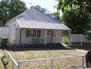
9-11 River Rd Cannington
Canning
Metropolitan
Constructed from 1900
| Type | Status | Date | Documents |
|---|---|---|---|
| (no listings) |
| Type | Status | Date | Documents |
|---|---|---|---|
| (no listings) |
| Type | Status | Date | Grading/Management | |
|---|---|---|---|---|
| Category | ||||
| Municipal Inventory | Adopted | 08 Aug 1995 | 4 | |
Individual Building or Group
| Epoch | General | Specific |
|---|---|---|
| Other Use | RESIDENTIAL | Single storey residence |
| Original Use | INDUSTRIAL\MANUFACTURING | Bakery |
| Present Use | RESIDENTIAL | Single storey residence |
| Type | General | Specific |
|---|---|---|
| Roof | ASBESTOS | Fibrous Cement, corrugated |
| Wall | ASBESTOS | Fibrous Cement, flat |
| General | Specific |
|---|---|
| DEMOGRAPHIC SETTLEMENT & MOBILITY | Settlements |
| OCCUPATIONS | Manufacturing & processing |
This information is provided voluntarily as a public service. The information provided is made available in good faith and is derived from sources believed to be reliable and accurate. However, the information is provided solely on the basis that readers will be responsible for making their own assessment of the matters discussed herein and are advised to verify all relevant representations, statements and information.
Local significance relating to the early settlement of the Canning area.
Timber framed, asbestos clad cottage with remnants of fabric, including timber framing and brick chimney, which indicate that it was constructed in the early 1900's. The building has been substantially altered and as a result has lost authenticity.
The land is believed to have been the site of an early bakery from the period of the Mason- Bird Timber Company although no evidence of this remains.
This information is provided voluntarily as a public service. The information provided is made available in good faith and is derived from sources believed to be reliable and accurate. However, the information is provided solely on the basis that readers will be responsible for making their own assessment of the matters discussed herein and are advised to verify all relevant representations, statements and information.
10 River Rd Cannington
Canning
Metropolitan
Constructed from 1940
| Type | Status | Date | Documents |
|---|---|---|---|
| (no listings) |
| Type | Status | Date | Documents |
|---|---|---|---|
| (no listings) |
| Type | Status | Date | Grading/Management | |
|---|---|---|---|---|
| Category | ||||
| Municipal Inventory | Adopted | 08 Aug 1995 | 3 | |
Individual Building or Group
| Epoch | General | Specific |
|---|---|---|
| Present Use | RESIDENTIAL | Single storey residence |
| Original Use | RESIDENTIAL | Single storey residence |
| Type | General | Specific |
|---|---|---|
| Other | RENDER | Other Render |
| Wall | BRICK | Common Brick |
| Roof | TILE | Cement Tile |
| General | Specific |
|---|---|
| DEMOGRAPHIC SETTLEMENT & MOBILITY | Settlements |
This information is provided voluntarily as a public service. The information provided is made available in good faith and is derived from sources believed to be reliable and accurate. However, the information is provided solely on the basis that readers will be responsible for making their own assessment of the matters discussed herein and are advised to verify all relevant representations, statements and information.
Local significance relating to the settlement of the Canning area.
Rendered brick and tile house built circa 1940s.
Construction date unknown - was in situ in 1953
This information is provided voluntarily as a public service. The information provided is made available in good faith and is derived from sources believed to be reliable and accurate. However, the information is provided solely on the basis that readers will be responsible for making their own assessment of the matters discussed herein and are advised to verify all relevant representations, statements and information.
301 Sevenoaks St Cannington
Canning
Metropolitan
Constructed from 1964
| Type | Status | Date | Documents |
|---|---|---|---|
| (no listings) |
| Type | Status | Date | Documents |
|---|---|---|---|
| (no listings) |
| Type | Status | Date | Grading/Management | |
|---|---|---|---|---|
| Category | ||||
| (no listings) | ||||
| Library Id | Title | Medium | Year Of Publication |
|---|---|---|---|
| 5523 | Cannington Senior High School : archival record. | Report | 2001 |
Individual Building or Group
| Epoch | General | Specific |
|---|---|---|
| Original Use | EDUCATIONAL | Secondary School |
| Present Use | EDUCATIONAL | Secondary School |
| Type | General | Specific |
|---|---|---|
| Wall | BRICK | Common Brick |
| Wall | CONCRETE | Concrete Block |
This information is provided voluntarily as a public service. The information provided is made available in good faith and is derived from sources believed to be reliable and accurate. However, the information is provided solely on the basis that readers will be responsible for making their own assessment of the matters discussed herein and are advised to verify all relevant representations, statements and information.
This information is provided voluntarily as a public service. The information provided is made available in good faith and is derived from sources believed to be reliable and accurate. However, the information is provided solely on the basis that readers will be responsible for making their own assessment of the matters discussed herein and are advised to verify all relevant representations, statements and information.
3 Short St Cannington
Canning
Metropolitan
Constructed from 1900
| Type | Status | Date | Documents |
|---|---|---|---|
| (no listings) |
| Type | Status | Date | Documents |
|---|---|---|---|
| (no listings) |
| Type | Status | Date | Grading/Management | |
|---|---|---|---|---|
| Category | ||||
| Municipal Inventory | Adopted | 08 Aug 1995 | 3 | |
Individual Building or Group
| Epoch | General | Specific |
|---|---|---|
| Original Use | RESIDENTIAL | Single storey residence |
| Present Use | RESIDENTIAL | Single storey residence |
| Type | General | Specific |
|---|---|---|
| Wall | TIMBER | Weatherboard |
| Roof | METAL | Corrugated Iron |
| General | Specific |
|---|---|
| DEMOGRAPHIC SETTLEMENT & MOBILITY | Settlements |
This information is provided voluntarily as a public service. The information provided is made available in good faith and is derived from sources believed to be reliable and accurate. However, the information is provided solely on the basis that readers will be responsible for making their own assessment of the matters discussed herein and are advised to verify all relevant representations, statements and information.
Constructed from 1900
Local significance relating to the early settlement of the Canning area.
Timber and iron house with a small gable over the entry which faces Albany Highway. Wide verandahs, double hung sash windows, turned verandah posts and other building details typically found in houses constructed circa 1900.
This information is provided voluntarily as a public service. The information provided is made available in good faith and is derived from sources believed to be reliable and accurate. However, the information is provided solely on the basis that readers will be responsible for making their own assessment of the matters discussed herein and are advised to verify all relevant representations, statements and information.
58 Stockman Way Cannington
Additional address details: corner of Sevenoaks Street. 6/1/2011 - VFL.
58 Stockman Way, Cnr Sevenoaks Street, Cannin
Canning
Metropolitan
Constructed from 1896
| Type | Status | Date | Documents |
|---|---|---|---|
| (no listings) |
| Type | Status | Date | Documents |
|---|---|---|---|
| RHP - Does not warrant assessment | Current | 25 Feb 2011 |
| Type | Status | Date | Grading/Management | |
|---|---|---|---|---|
| Category | ||||
| (no listings) | ||||
Owner had used original brick in the construction of fireplace
Individual Building or Group
| Epoch | General | Specific |
|---|---|---|
| Original Use | COMMERCIAL | Shop\Retail Store {single} |
| Present Use | RESIDENTIAL | Single storey residence |
| Type | General | Specific |
|---|---|---|
| Wall | TIMBER | Weatherboard |
| Wall | PLASTER | Lathe and Plaster |
| Wall | BRICK | Common Brick |
| Roof | METAL | Corrugated Iron |
This information is provided voluntarily as a public service. The information provided is made available in good faith and is derived from sources believed to be reliable and accurate. However, the information is provided solely on the basis that readers will be responsible for making their own assessment of the matters discussed herein and are advised to verify all relevant representations, statements and information.
147 Wharf St Cannington
Includes former Treasure Residence
Canning
Metropolitan
| Type | Status | Date | Documents |
|---|---|---|---|
| (no listings) |
| Type | Status | Date | Documents |
|---|---|---|---|
| (no listings) |
| Type | Status | Date | Grading/Management | |
|---|---|---|---|---|
| Category | ||||
| (no listings) | ||||
| Library Id | Title | Medium | Year Of Publication |
|---|---|---|---|
| 4720 | Archival record : Treasure House, Wharf Road. | Heritage Study {Other} | 2000 |
Individual Building or Group
| Epoch | General | Specific |
|---|---|---|
| Present Use | EDUCATIONAL | Primary School |
| Original Use | RESIDENTIAL | Single storey residence |
This information is provided voluntarily as a public service. The information provided is made available in good faith and is derived from sources believed to be reliable and accurate. However, the information is provided solely on the basis that readers will be responsible for making their own assessment of the matters discussed herein and are advised to verify all relevant representations, statements and information.
1 Woodloes St Cannington
Lot 101 and 102 on Plan 302456
Canning
Metropolitan
Constructed from 1880
| Type | Status | Date | Documents |
|---|---|---|---|
| Heritage List | Adopted | 18 Sep 2018 |
| Type | Status | Date | Documents |
|---|---|---|---|
| RHP - Does not warrant assessment | Current | 10 Feb 2023 |
| Type | Status | Date | Grading/Management | |
|---|---|---|---|---|
| Category | ||||
| Municipal Inventory | Adopted | 08 Aug 1995 | 3 | |
| Municipal Inventory | Adopted | 17 Oct 2017 | 3 | |
Individual Building or Group
| Epoch | General | Specific |
|---|---|---|
| Present Use | RESIDENTIAL | Single storey residence |
| Original Use | RESIDENTIAL | Single storey residence |
| Type | General | Specific |
|---|---|---|
| Roof | METAL | Corrugated Iron |
| Wall | TIMBER | Other Timber |
| General | Specific |
|---|---|
| DEMOGRAPHIC SETTLEMENT & MOBILITY | Settlements |
This information is provided voluntarily as a public service. The information provided is made available in good faith and is derived from sources believed to be reliable and accurate. However, the information is provided solely on the basis that readers will be responsible for making their own assessment of the matters discussed herein and are advised to verify all relevant representations, statements and information.
Constructed from 1900
The single storey timber and iron building has cultural heritage significance for the following reasons: The place is a modest example of a weatherboard and iron Federation residence, it is one of only a few early residences left in the area which provide the district with a sense of history and a link to its past. The place is associated with the early development of the area, which for many years was used for agriculture, and is one of the few places pre-dating suburban development still left in the area. As a weatherboard structure, the place has some rarity value as it represents a building material that is no longer widely used in the construction of buildings in Perth. The place is representative of the timber building stock that was common to the Canning locality during its development in the early twentieth century. It is also representative of a simple vernacular building style associated with rural towns and their early settlement.
The subject place is located along the western side of Woodloes Street and is setback approximately 7 metres from the front boundary. A low, open timber picket and rail fence delineates it from the front boundary. The dwelling has a pyramid hip roof clad with short sheets of corrugated sheeting. A skillion verandah is supported by 4 square posts with decorative filigree brackets. The verandah floor is timber. It has a single room street frontage with a timber panel front door located towards the northern end of the façade. There is a 3-panel timber window with security grills along the southern end of the front façade. The central panel is fixed and flanked by two sash windows. The place consists of 2 bedrooms, kitchen/dining with gas cooker, air conditioner and a lounge area. There is also a single garage.
The Canning Road District was one of the early areas to be gazetted under the Roads Boards Act in 1871. In the early days, much of the activity in the area was focused around Mason’s Landing. It was not until 1893, when the railway line came through that the town of Cannington really came into its own, and which resulted in a shift in focus away from the river. Old plans of the area suggest the original land grant, where the subject place was situated was allocated to Alfred Waylen in 1841. The original grant comprised 578 acres, which was located on the eastern side of the river from what is now known as Nicholson Road to the timber landing (presumably Mason’s). It was known as Location 5. Subsequent ownership is noted below: 1. Mr Alfred Waylen 578 acres 1841-1868 2. Mr Benjamin Mason 578 acres 1868-1871 3. Mr Francis Bird & family & Mr Henry Hetherington 578 acres 1871-1882 4. Mr Joseph Shaw 578 acres 1882-1886 5. Mr William E Marmion & Mr Robert Sholl 542 acres 1886-1896 The Estate was subdivided by Alfred Edward Morgans and Frank Wilson in 1900 following the death of Mr William E Marmion. It was 18 acres less than the original land grant as some land had been taken for the South West Railway, Albany Road and the Tramway and Road from Bickley Valley to Canning Landing. A Certificate of Title was issues for Lots 43, 44 and 45 in May 1901, which covered all the land comprising what is known today as Nos. 1 and 3 Woodloes Street. The Title was issued to George Fairbrother. Twenty-one years later in 1922, the land was transferred to Christianna Broadbent. In 1927 this landholding was subdivided to form two separate land parcels, which are today known as Nos. 1 and 3 Woodloes Street. The title for No. 3 Woodloes Street was issued to Building Inspector Cecil Leslie Thorpe at this time. Christianna Broadbent maintained ownership of the subject place at No. 1 Woodloes Street. Cecil Leslie Thorpe married Mrs Broadbent’s youngest daughter Grace in 1928. It is likely Mrs Boardbent subdivided her landholding to enable the young couple to build a house and live close by in Cannington. Ownership of No. 1 Woodloes Street changed on numerous occasions as noted below: 1. Thomas Clifton Transport Driver 1950 2. Desmond O’Day & Dorothy McDonough Hair dresser 1955 3. Desmond O’Day & Margaret Clarke - 2003 4. Sherryl Brown & Alexander Brown 2004
Integrity and Authenticity - both High
Good
| Ref ID No | Ref Name | Ref Source | Ref Date |
|---|---|---|---|
| Woodloes Homestead Conservation Plan | Conservation Plan | March 2015 | |
| Sunday Times | Newspaper | 24 June 1928 |
| Reserve | Lot/Location | Plan/Diagram | Vol/Folio |
|---|---|---|---|
| 101 and 102 | 302456 | 986/38 |
| Owner | Category |
|---|---|
| S & A Brown | Other Private |
This information is provided voluntarily as a public service. The information provided is made available in good faith and is derived from sources believed to be reliable and accurate. However, the information is provided solely on the basis that readers will be responsible for making their own assessment of the matters discussed herein and are advised to verify all relevant representations, statements and information.
14 Woodloes St Cannington
Canning
Metropolitan
| Type | Status | Date | Documents |
|---|---|---|---|
| (no listings) |
| Type | Status | Date | Documents |
|---|---|---|---|
| (no listings) |
| Type | Status | Date | Grading/Management | |
|---|---|---|---|---|
| Category | ||||
| Municipal Inventory | Adopted | 08 Aug 1995 | 4 | |
Individual Building or Group
| Epoch | General | Specific |
|---|---|---|
| Original Use | SOCIAL\RECREATIONAL | Masonic Hall |
| Present Use | SOCIAL\RECREATIONAL | Masonic Hall |
| Type | General | Specific |
|---|---|---|
| Roof | ASBESTOS | Fibrous Cement, corrugated |
| Wall | BRICK | Common Brick |
| General | Specific |
|---|---|
| SOCIAL & CIVIC ACTIVITIES | Institutions |
This information is provided voluntarily as a public service. The information provided is made available in good faith and is derived from sources believed to be reliable and accurate. However, the information is provided solely on the basis that readers will be responsible for making their own assessment of the matters discussed herein and are advised to verify all relevant representations, statements and information.
Social significance to the local Masonic community.
Brick hall with asbestos roof. Has been extended.
This information is provided voluntarily as a public service. The information provided is made available in good faith and is derived from sources believed to be reliable and accurate. However, the information is provided solely on the basis that readers will be responsible for making their own assessment of the matters discussed herein and are advised to verify all relevant representations, statements and information.
19 Woodloes St Cannington
Canning
Metropolitan
Constructed from 1890
| Type | Status | Date | Documents |
|---|---|---|---|
| (no listings) |
| Type | Status | Date | Documents |
|---|---|---|---|
| (no listings) |
| Type | Status | Date | Grading/Management | |
|---|---|---|---|---|
| Category | ||||
| Municipal Inventory | Adopted | 08 Aug 1995 | 3 | |
Individual Building or Group
| Epoch | General | Specific |
|---|---|---|
| Original Use | RESIDENTIAL | Single storey residence |
| Present Use | RESIDENTIAL | Single storey residence |
| Type | General | Specific |
|---|---|---|
| Wall | TIMBER | Other Timber |
| Roof | METAL | Corrugated Iron |
| General | Specific |
|---|---|
| DEMOGRAPHIC SETTLEMENT & MOBILITY | Settlements |
This information is provided voluntarily as a public service. The information provided is made available in good faith and is derived from sources believed to be reliable and accurate. However, the information is provided solely on the basis that readers will be responsible for making their own assessment of the matters discussed herein and are advised to verify all relevant representations, statements and information.
Local significance relating to the early settlement of the Canning area.
Timber and iron cottage with gable fronted roof. Probably built circa 1890s to early 1900s.
This information is provided voluntarily as a public service. The information provided is made available in good faith and is derived from sources believed to be reliable and accurate. However, the information is provided solely on the basis that readers will be responsible for making their own assessment of the matters discussed herein and are advised to verify all relevant representations, statements and information.
3 Woodloes St Cannington
Canning
Metropolitan
Constructed from 1880
| Type | Status | Date | Documents |
|---|---|---|---|
| (no listings) |
| Type | Status | Date | Documents |
|---|---|---|---|
| (no listings) |
| Type | Status | Date | Grading/Management | |
|---|---|---|---|---|
| Category | ||||
| Municipal Inventory | Adopted | 08 Aug 1995 | 3 | |
Individual Building or Group
| Epoch | General | Specific |
|---|---|---|
| Original Use | RESIDENTIAL | Single storey residence |
| Present Use | RESIDENTIAL | Single storey residence |
| Type | General | Specific |
|---|---|---|
| Wall | TIMBER | Other Timber |
| Roof | METAL | Corrugated Iron |
| General | Specific |
|---|---|
| DEMOGRAPHIC SETTLEMENT & MOBILITY | Settlements |
This information is provided voluntarily as a public service. The information provided is made available in good faith and is derived from sources believed to be reliable and accurate. However, the information is provided solely on the basis that readers will be responsible for making their own assessment of the matters discussed herein and are advised to verify all relevant representations, statements and information.
Local significance relating to the early settlement of the Canning area.
Timber and iron cottage, probably built circa 1880s. Has been altered.
This information is provided voluntarily as a public service. The information provided is made available in good faith and is derived from sources believed to be reliable and accurate. However, the information is provided solely on the basis that readers will be responsible for making their own assessment of the matters discussed herein and are advised to verify all relevant representations, statements and information.
39 Woodloes St Cannington
Lot 808, Plan P39692
Canning
Metropolitan
Constructed from 1871
| Type | Status | Date | Documents |
|---|---|---|---|
| Heritage List | Adopted | 18 Sep 2018 | |
| State Register | Registered | 21 Jan 1997 | HCWebsite.Listing+ListingDocument, HCWebsite.Listing+ListingDocument |
| Type | Status | Date | Documents |
|---|---|---|---|
| (no listings) |
| Type | Status | Date | Grading/Management | |
|---|---|---|---|---|
| Category | ||||
| Classified by the National Trust | Classified | 15 Oct 1988 | ||
| Register of the National Estate | Nominated | 17 May 1991 | ||
| Register of the National Estate | Indicative Place | |||
| Municipal Inventory | Adopted | 17 Oct 2017 | 1 | |
| Name | Type | Year From | Year To |
|---|---|---|---|
| Bird, Francis | Architect | - | - |
| Library Id | Title | Medium | Year Of Publication |
|---|---|---|---|
| 11358 | Cast iron pillar boxes of Western Australia: An early history of the J & E Ledger foundry | Book | 2015 |
| 4870 | Woodloes Homestead, Cannington : conservation plan. | Heritage Study {Other} | 1993 |
| 2322 | The Mason and Bird Timber Company 1862 to 1882. | Book | 1978 |
Individual Building or Group
| Epoch | General | Specific |
|---|---|---|
| Present Use | EDUCATIONAL | Museum |
| Original Use | FARMING\PASTORAL | Homestead |
| Style |
|---|
| Victorian Georgian |
| Type | General | Specific |
|---|---|---|
| Roof | TIMBER | Shingle |
| Wall | STONE | Limestone |
| General | Specific |
|---|---|
| DEMOGRAPHIC SETTLEMENT & MOBILITY | Settlements |
| OCCUPATIONS | Timber industry |
| PEOPLE | Early settlers |
This information is provided voluntarily as a public service. The information provided is made available in good faith and is derived from sources believed to be reliable and accurate. However, the information is provided solely on the basis that readers will be responsible for making their own assessment of the matters discussed herein and are advised to verify all relevant representations, statements and information.
Constructed from 1871
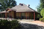
Woodloes Homestead, a Victorian Georgian home with shingled roof, an attic, and verandahs to four sides, has cultural heritage significance for the following reasons: it is a rare example of an early architect designed house south of the Swan River in the Perth area; the original owner (and architect), Francis Bird, was a key figure in the development of the Western Australian timber industry, and one of the largest employers in Western Australia; the place maintains a connection with the Canning River that is currently uninterrupted (except for a recent security fence) and is thus almost unchanged from the original relationship; the quality of timber workmanship is exemplary; the place is a rare example of the type of dwelling constructed by wealthy Western Australian families in the Victorian era, largely intact, with sufficient information being available to allow appropriate conservation work to be undertaken; the house sits on a site that was part of a much larger plot containing a landing stage crucial to the development of the Mason Bird timber industry, providing river transport to Perth and Fremantle prior to the advent of rail transport, an historical connection that was important in the development of the locality; and, the relatively rare bunya bunya pine (a local landmark), the fig tree and two olive trees amongst the other historic, mature trees identified as a collection, are important for their contribution to the aesthetic values of the property and the setting of the house and are representative of exotic species that were popularly planted in the late 19th and early 20th centuries in Western Australia. The shed, gazebo, blacksmith shop, water tank and reconstructed church are considered to be intrusive and do not possess cultural heritage significance.
The building is a square plan Victorian Georgian homestead consisting of six rooms at ground floor, an attic room and a cellar. The building is typical of homesteads of the period with a central passage and rooms on either side. The building has steeply pitched she-oak shingle roof that is penetrated by two white painted brick chimneys and a small dormer window to the eastern pitch. The she-oak shingles were replaced by galvanized corrugated iron in Dec 2018/Jan 2019. There are open verandahs to all four sides supported by timber posts. The verandah sits on limestone masonry dwarf walls and has timber boards. The construction is primarily rubble limestone with brick quoining around openings. Internally the building is largely original. There has been some change during the 1970s restoration, with the partial removal of the original lath and plaster ceilings and partial new timber floorboards. The décor is an interpretation of a Victorian period home. The homestead is located on a site adjacent to the Canning River. The landscaping and character of the site has been altered, however some remnants of the original plantings remain, including a mature Bunya Pine, which is considered to be a fine example of its type. The site currently contains a number of more recently acquired features, which are not original including a replica of the Congregational Church (also known as the Church with a Chimney) and a post box.
The history of Woodloes Homestead is entwined with that of Benjamin Mason and Francis Bird. The Mason Bird & Company was a prominent, albeit short lived, business operation in the early Western Australian timber industry. After felling timber in the Darling Ranges the company would float the timber on flat bottomed barges down the Canning River to Mason’s Landing which existed a short distance upstream from Woodloes. Francis Bird arrived from England into Fremantle in October 1869. Upon arriving he invested in the Mason Bird & Co, which supplied the timber for much of the State’s early infrastructure including the timber for the roof of Perth Town Hall, Fremantle Lunatic Asylum (now Fremantle Arts Centre) and the Geraldton to Northampton Railway. Following the liquidation of the Mason Bird & Company partnership on the 18 June 1873 it appears Francis Bird continued on his own for some years. Francis Bird, who was a trained architect, designed and built Woodloes Homestead in the early 1870s; some accounts place the date at 1874. He named the house after one in which he lived for a portion of his early adulthood in England. Francis Bird married Augusta Maud Earnshaw in 1871. Seven of their fifteen children were born at Woodloes. Three children died at birth and at least one of these is believed to have been buried there. In 1882 Francis Bird sold Woodloes Homestead and became Chief Government Architect in 1883. In 1882 Woodloes was purchased by Joseph Shaw. The Homestead had nine owners between 1883 and 1974. The lot was subdivided from the original land holding several times and subsequently became much reduced to its current size. In 1974 it was purchased by the City of Canning with the intention of providing a venue for the Historical Society and establishing a museum. A schedule of repair works was prepared by D. Brearey, the Town of Canning Property Officer, dated 31st March 1976. The works were undertaken over a number of phases and were completed in 1978. These works included (but are not limited to) removing the iron sheet roofing and reinstating shingle roof cladding; defective paint and render was removed to better reveal the stonework; and Jarrah finishes were repaired and partly replaced including floors, skirtings, door thresholds and framing. Woodloes was opened to the public on the 5th June 1978. To the north-west of the site there is the Congregational Church (also known as the Church with a Chimney), which was rebuilt at Woodloes in the 1990s when Albany Highway was widened by 17 metres. Some materials from the original church were used in this reconstruction. The Church is managed by the Canning District Historical Society and hired out for functions.
High: although it is now a museum, its original use as a residence remains evident Alterations: Various alterations including changes to the dormer windows, removal of interior walls, removal of a gable over the entrance and replacement of roof shingles with corrugated iron sheets occurred over the history of the building. However the building form has always remained substantially as originally constructed. Intactness of fabric: The building was restored in the 1970s with an extensive amount of reconstruction of elements due to the poor condition of the existing fabric. Some detailing is as original however some aspects of the building are not as originally constructed.
Good - well maintained
| Ref ID No | Ref Name | Ref Source | Ref Date |
|---|---|---|---|
| G MacDonald & W Cooper; "The Gosnells Story". | City of Gosnells | 1988 | |
| Kevin Palassis Architects; "Conservation Plan, Woodloes Homestead, Cannington". | Prepared for the National | 1993 |
| Reserve | Lot/Location | Plan/Diagram | Vol/Folio |
|---|---|---|---|
| 808 | P39692 | 2554/894 |
| Owner | Category |
|---|---|
| City of Canning | Local Gov't |
This information is provided voluntarily as a public service. The information provided is made available in good faith and is derived from sources believed to be reliable and accurate. However, the information is provided solely on the basis that readers will be responsible for making their own assessment of the matters discussed herein and are advised to verify all relevant representations, statements and information.
Woodloes homestead holds considerable interest as it is the oldest existing home in Canning which is close to its original state. From 1841 this homestead has had many owners including Mrs Elizabeth D. Brockman (1900 - 1911); previous property owner Benjamin Mason (1860 - 1871) joined a following owner and architect Francis Bird to form a pioneer timber company. Francis Bird designed and built woodloes in 1871, becoming one of the few architect designed homes in the colony. Bird became first Chairman of Canning Board at 26 years old. The nearby Masons Landing is at the site of the original mill. Bird became Chief Government Architect in 1883 - 1884, and was later associated with "Strawberry Farm", Albany and Albany's Court House. Ticket of leave men were availed to assist in the building of Woodloes Homestead.
This simple, early colonial residential building of rendered masonry, with pit sawn timbers, some brick construction, 6 rooms plus kitchen, an attic and a cellar has been restored with extreme care. A shingle roof has replaced iron roofing as was the original. An outside bakers oven near the kitchen exists. The attic room is completely restored and the cellar where Ticket of Leave men were held, is restored to be used for displaying artifacts of the era. A blacksmiths shop and shed has been erected at the rear of the homestead. A Bunya Bunya Pine tree dated prior to 1900 stands in the front garden, under which one of the Bird's children is reputed to be buried.
Assessment 1988 Construction: c.1871 Original Owner: Francis Bird 1871/1882
This information is provided voluntarily as a public service. The information provided is made available in good faith and is derived from sources believed to be reliable and accurate. However, the information is provided solely on the basis that readers will be responsible for making their own assessment of the matters discussed herein and are advised to verify all relevant representations, statements and information.
44 Woodloes St Cannington
Canning
Metropolitan
Constructed from 1963
| Type | Status | Date | Documents |
|---|---|---|---|
| (no listings) |
| Type | Status | Date | Documents |
|---|---|---|---|
| (no listings) |
| Type | Status | Date | Grading/Management | |
|---|---|---|---|---|
| Category | ||||
| Uniting Church Inventory | Completed | 01 Oct 1996 | ||
Individual Building or Group
| Epoch | General | Specific |
|---|---|---|
| Original Use | RELIGIOUS | Church Hall |
| Present Use | RELIGIOUS | Church, Cathedral or Chapel |
| Original Use | RELIGIOUS | Church, Cathedral or Chapel |
| Present Use | RELIGIOUS | Church Hall |
| RELIGIOUS | Other |
| Type | General | Specific |
|---|---|---|
| Wall | BRICK | Common Brick |
| Roof | TILE | Ceramic Tile |
| Roof | METAL | Corrugated Iron |
| General | Specific |
|---|---|
| SOCIAL & CIVIC ACTIVITIES | Religion |
This information is provided voluntarily as a public service. The information provided is made available in good faith and is derived from sources believed to be reliable and accurate. However, the information is provided solely on the basis that readers will be responsible for making their own assessment of the matters discussed herein and are advised to verify all relevant representations, statements and information.
36 Woodloes St Cannington
Canning
Metropolitan
Constructed from 1920
| Type | Status | Date | Documents |
|---|---|---|---|
| (no listings) |
| Type | Status | Date | Documents |
|---|---|---|---|
| (no listings) |
| Type | Status | Date | Grading/Management | |
|---|---|---|---|---|
| Category | ||||
| Municipal Inventory | Adopted | 08 Aug 1995 | 3 | |
Individual Building or Group
| Epoch | General | Specific |
|---|---|---|
| Present Use | RESIDENTIAL | Single storey residence |
| Original Use | RESIDENTIAL | Single storey residence |
| Type | General | Specific |
|---|---|---|
| Wall | CONCRETE | Concrete Block |
| Roof | METAL | Corrugated Iron |
| General | Specific |
|---|---|
| DEMOGRAPHIC SETTLEMENT & MOBILITY | Settlements |
This information is provided voluntarily as a public service. The information provided is made available in good faith and is derived from sources believed to be reliable and accurate. However, the information is provided solely on the basis that readers will be responsible for making their own assessment of the matters discussed herein and are advised to verify all relevant representations, statements and information.
Local significance relating to the settlement of the Canning area.
House constructed of concrete blocks which have been rendered and painted, with an iron roof. Probably built 1920s or 30s.
This information is provided voluntarily as a public service. The information provided is made available in good faith and is derived from sources believed to be reliable and accurate. However, the information is provided solely on the basis that readers will be responsible for making their own assessment of the matters discussed herein and are advised to verify all relevant representations, statements and information.
56 Redcliffe St East Cannington
Canning
Metropolitan
Constructed from 1957
| Type | Status | Date | Documents |
|---|---|---|---|
| Heritage List | Adopted | 18 Sep 2018 |
| Type | Status | Date | Documents |
|---|---|---|---|
| (no listings) |
| Type | Status | Date | Grading/Management | |
|---|---|---|---|---|
| Category | ||||
| Catholic Church Inventory | Adopted | 01 Jul 1998 | ||
| Municipal Inventory | Adopted | 15 Sep 2015 | 3 | |
| Municipal Inventory | Adopted | 17 Oct 2017 | 3 | |
sound - some rising damp
Individual Building or Group
| Epoch | General | Specific |
|---|---|---|
| Present Use | RELIGIOUS | Church, Cathedral or Chapel |
| Original Use | RELIGIOUS | Church, Cathedral or Chapel |
| Style |
|---|
| Post-War Ecclesiastical |
| Type | General | Specific |
|---|---|---|
| Wall | BRICK | Rendered Brick |
| Roof | TILE | Ceramic Tile |
| General | Specific |
|---|---|
| SOCIAL & CIVIC ACTIVITIES | Religion |
This information is provided voluntarily as a public service. The information provided is made available in good faith and is derived from sources believed to be reliable and accurate. However, the information is provided solely on the basis that readers will be responsible for making their own assessment of the matters discussed herein and are advised to verify all relevant representations, statements and information.
Constructed from 1985 to 1995, Constructed from 1954
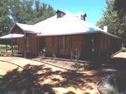
The single storey brick and tile Church has cultural heritage significance for the following reasons: It is an example of the Mid-twentieth Century Australian ecclesiastical vernacular and is a distinctive building in Redcliffe Street. It has historic significance to the City of Canning and to the East Cannington area in particular reflecting the role of the Catholic Church in the community. The church is valued by the local church community and as a place distinctive in the local landscape, it makes a positive contribution to the local ‘sense of place’ and local identity.
The subject place is located along the northern side of Redcliffe between Lacey and Crawford Streets. Within the lot there is the church, a Parish house and a small hall. The balance of the street comprises residences largely constructed in the 1950/60s. The church has a tile gable roof form, which faces the street. Its front façade is exposed red brick. The front façade has two vertical windows flanking a semi-circular window. A sculpture of St Francis is set within the top of the façade. The side elevations have been rendered. The original portion of the Church has a slightly higher wall plate that the late Twentieth Century addition. Both the old and new gable ends have a cross at the peak.
The name East Cannington is descriptive of the district being situated east of Cannington Station. Boundaries for this suburb were first defined in 1959 Metropolitan Street Directory. Previously, East Cannington was a part of the suburb of Queens Park. St Francis Church was constructed in 1954. It was originally a smaller Church building, however between 1985 and 1995 a large addition was constructed to the front of the Church concealing the original façade.
Integrity: High Authenticity: High
Good
| Ref ID No | Ref Name | Ref Source | Ref Date |
|---|---|---|---|
| Parish of Apostolate | Website |
| Reserve | Lot/Location | Plan/Diagram | Vol/Folio |
|---|---|---|---|
| 11 | 76214 | 1867/875 |
| Owner | Category |
|---|---|
| Catholic Church | Church Property |
This information is provided voluntarily as a public service. The information provided is made available in good faith and is derived from sources believed to be reliable and accurate. However, the information is provided solely on the basis that readers will be responsible for making their own assessment of the matters discussed herein and are advised to verify all relevant representations, statements and information.
Lot 4973 Sevenoaks Street East Cannington
Canning
Metropolitan
| Type | Status | Date | Documents |
|---|---|---|---|
| (no listings) |
| Type | Status | Date | Documents |
|---|---|---|---|
| (no listings) |
| Type | Status | Date | Grading/Management | |
|---|---|---|---|---|
| Category | ||||
| Municipal Inventory | Adopted | 17 Oct 2017 | 5 | |
Historic Site
| Epoch | General | Specific |
|---|---|---|
| Original Use | Transport\Communications | Rail: Railway Station |
This information is provided voluntarily as a public service. The information provided is made available in good faith and is derived from sources believed to be reliable and accurate. However, the information is provided solely on the basis that readers will be responsible for making their own assessment of the matters discussed herein and are advised to verify all relevant representations, statements and information.
Constructed from 1893 to 1970
Cannington Railway Station Precinct, represents the development of the South Western Railway system. The site represents the beginnings of the town, the development of motorised transport and demonstrates associations with early settlers of the town.
The old Cannington railway station is no longer present as it was demolished in 1989. Whilst the station is no longer in existence, a reinstated railway line and several original buildings surrounding the former station still remain which were part of the original Cannington Railway Station precinct.
The place as associated with the development of the suburb of Cannington. The place was associated with providing transport for visitors to the Canning Agricultural Show from the greater Perth metropolitan and regional area. The place is associated with the work of engineer C.Y. O’Connor, during which period a number of significant infrastructure projects were completed in throughout the State. The South Western Railway (SWR) from East Perth-Pinjarra opened on 2 May 1893. Cannington was one of the original stations and opened with the railway. The railway was originally single track, with the rails on the Sevenoaks Street side of the platform. The contract drawings for the SWR show that Cannington was provided with a 4th Class station building, 40ft by 30ft goods shed, 4th Class station master’s house, 250ft long passenger platform, and a 55ft-long goods loading bank. The station building was based on a New Zealand Railways design, introduced by C.Y. O’Connor when he became Engineer-in-Chief in 1890 (His signature is on the contract plans). Strangely, the old Cannington Station building is a mirror image of the contract plan, with the arrangement of rooms reversed. This building had a verandah fitted later to the western side, but remained largely the same structure until demolished in the 1970’s1. A ‘Station Master’ was appointed to the station from 2 May 1893 until 8 September 1989. A double track was completed from Burswood-Maddington on 3 January 1904 and the new line of rails was laid on the Railway Parade side of the platform. The station then became an island platform, with this platform later being extended to 450 feet long. In February 1897, a water main was laid from Victoria Reservoir to Perth and the pipeline was laid under the railway approximately 850m south of the old Cannington Railway Station. In September 1897, a round 6000 gallon iron tank was erected alongside the track, 145m south of the station building and used for supplying water to steam locomotives. After the double track was completed in 1904, this tank ended up between the two lines of rails. In 1913, a new pedestrian overhead bridge as built and a new 5000 gallon tank erected opposite the old site towards Railway Parade. The loading bank was removed in November 1964 and the stockyards were removed in July 1966. The goods shed ceased to be used from September 1970. A water column was placed near the rails and was used until the end of steam locomotive working through Cannington in early 1971. The station attracted passengers through events such as the Canning Show and the expansion of Carousel Shopping Centre, and was for promotion in new estate plans. The old station building was demolished later throughout the 1970’s, and a new brick building constructed for the station master and staff. The station closed on 8 September 1989 and on 26 September the same year, the new bus/rail station opened further northwest as the new Cannington Station which currently exists today. The old station and platform were demolished on 25-29 September 1989. Today, the old station site now serves as a car parking area for the existing Cannington Train Station and contains an electric substation. The former station is surrounded by several original buildings which as a commercial, retail and residential uses. Whilst these surrounding building do not form within the railway site, their proximity to the station suggests its existence as being subsequent to the operation of the railway station.
Low
| Reserve | Lot/Location | Plan/Diagram | Vol/Folio |
|---|---|---|---|
| 4973 | 36744 | LR3131/253 |
| Owner | Category |
|---|---|
| State of Western Australia | State Gov't |
This information is provided voluntarily as a public service. The information provided is made available in good faith and is derived from sources believed to be reliable and accurate. However, the information is provided solely on the basis that readers will be responsible for making their own assessment of the matters discussed herein and are advised to verify all relevant representations, statements and information.
Bicentennial Adenia Reserve Ferndale
Canning River Regional Park; Lot 921, Plan P240087
Cremation Site
Canning
Metropolitan
Constructed from 1932
| Type | Status | Date | Documents |
|---|---|---|---|
| Heritage List | Adopted | 18 Sep 2018 | |
| State Register | Registered | 02 Sep 1997 | HCWebsite.Listing+ListingDocument, HCWebsite.Listing+ListingDocument |
| Type | Status | Date | Documents |
|---|---|---|---|
| (no listings) |
| Type | Status | Date | Grading/Management | |
|---|---|---|---|---|
| Category | ||||
| Municipal Inventory | Adopted | 08 Aug 1995 | 5 | |
| Municipal Inventory | Adopted | 17 Oct 2017 | 1 | |
Historic Site
| Epoch | General | Specific |
|---|---|---|
| Original Use | MONUMENT\CEMETERY | Cemetery |
| Present Use | PARK\RESERVE | Park\Reserve |
| Style |
|---|
| Other Style |
| General | Specific |
|---|---|
| DEMOGRAPHIC SETTLEMENT & MOBILITY | Immigration, emigration & refugees |
| SOCIAL & CIVIC ACTIVITIES | Religion |
This information is provided voluntarily as a public service. The information provided is made available in good faith and is derived from sources believed to be reliable and accurate. However, the information is provided solely on the basis that readers will be responsible for making their own assessment of the matters discussed herein and are advised to verify all relevant representations, statements and information.
Social importance is that of all burial grounds for their respective communities. Historically important because of the part Afghans played in the settlement of this state. The history of this dis-used site demonstrates the way of life, and customs of early pioneers - namely the Afghan people. The awareness of a Sikh (Afghan) Crematorium-cemetery in the metropolitan area makes us begin to understand the development of cultural phases in settling this large state.
The area is low lying and swampy. Afghans were reluctant to discuss details of their religious observances, but it was said that their cremations took place where there was running water alongside the funeral pyre. It was traditional to cast the ashes on the water – where the water was still. The ashes were lowered in an urn. The ashes were then buried in the earth where there was no water.
Assessment 1990 The Sikhs are a sect of reigious dissenters from Hinduism. They originated in the Punjab regions of India. They were mostly camel drivers - and these cameleers were really the lifeblood of the goldfields. The would come back to Perth to die, when possible. I In 1932 the site was vested in the names of Bulla Singh and Massa Singh for the purpose of a Sikh cemetery. n 1970 the spokesman for the Sikh community in Western Australia was Harbhajan Singh of Dianella.
This information is provided voluntarily as a public service. The information provided is made available in good faith and is derived from sources believed to be reliable and accurate. However, the information is provided solely on the basis that readers will be responsible for making their own assessment of the matters discussed herein and are advised to verify all relevant representations, statements and information.
Constructed from 1932
The site is important for historic reasons because of its association with the religious rituals of the small Sikh communiyt of Western Australia. Cremation was not generally permitted in Western Australia until the passing of the Cremations Act 1929, although some cremations of people of 'Asiatic race', took place in country areas and at Woodman's Point Quarantine Station before that date and before the building of crematorium facilities at Karrakatta Cemetary in the late 1930's. The site therefore has importance as part of the broader history of cemetaries and religious pracitses associated with the disposal if the dead in Western Australia and is closely associated with the passing of the Cremations Act 1929 and the acceptance of cremation in the wider community. The site has social value for the Sikh community because of its religious associations and because it contributes to a recognition of the Sikh communiyt as a part of thr history of the state.
Fmr Sikh Cemetery is a small area of 0.2 hectares, formally a ‘C’ class reserve within the Bicentennial Adenia Reserve, located in Ferndale. The present public open space was modified as part of the redevelopment of the area in the late 1980s, as a result of minor earthworks and tree planting. A group of rocks record the site upon which a plaque is mounted. The stones are located approximately 62 metres within the park to the north-west of the Duff and Adenia Road intersection. The bronze plaque reads as follows: ‘Sikh Heritage Cremation Site – Adenia Recreation Reserve – In memory of the Sikh Pioneers who contributed towards the opening up and development of the south west, central and eastern goldfields regions of Western Australia. Sikh Association of WA Canning City Council Canning Districts Historical Society – 2nd November 1992. Plaque donated by Hazel and John Parker C.D.H.S stone donated by Readymix Gosnells Quarry.’
HISTORICAL INFORMATION Sikhs are known to have arrived in Western Australia in the early 19th century although it is probable that a greater number of them arrived during the second half of the century. Shiploads of camels were brought to Australia in the 1860s and, although their handlers were known as ‘Afghans’, there were Sikhs among them. Many early Sikh settlers worked as camel handlers, while others travelled around WA selling wares. The annulment of the White Australia Policy in 1973 saw increased opportunities for Sikh migration with Sikhs coming to Western Australia from India, the United Kingdom, east Africa, Singapore, Malaysia and Fiji. In Sikhism cremation is the usual method for disposal of remains regardless of the age of the deceased. A small C Class reserve occupying 0.2ha (0.5acres), was gazetted in 1932 as Reserve 20968 for the purpose of a Sikh cemetery after a dying Sikh man immolated himself, fearing that he would be buried. At the time the area was isolated and largely undeveloped with few residents living in the vicinity. An article in The Mirror newspaper provides detail of a cremation at the subject place in June 1934. The article reports that a big pyre was built with banksia logs to cremate a deceased Sikh man and that three days after the cremation the mourners would return to the burial ground to collect every particle of ash to throw into the Canning River. By 1898, the Sikh community was well established, although lacking recognition, both as a separate ethnic community, and as British citizens. The reserve was vested in two members of the Sikh community, Bulla and Massa Singh. In 1971, the Sikh community sought to have the vesting altered as neither Bulla or Massa were alive. They also sought to have the size of the reserve extended. The reserve was cancelled in 1977 and reverted to public open space. Landscaping and earthworks took place over the site in the late 1980s, when the Canning Regional Park was developed. In 2011, a plaque at the Sikh Cemetery in Ferndale was placed in-situ.
Low
| Ref ID No | Ref Name | Ref Source | Ref Date |
|---|---|---|---|
| National Trust Classification | 2016 | ||
| Richards; "Canning River Regional Park, Western Australia: Historical Survey". pp66, 67 & 72 | City of Canning | 1991 |
| Reserve | Lot/Location | Plan/Diagram | Vol/Folio |
|---|---|---|---|
| 921 | 240087 | 3055/958 |
| Owner | Category |
|---|---|
| State of Western Australia | State Gov't |
This information is provided voluntarily as a public service. The information provided is made available in good faith and is derived from sources believed to be reliable and accurate. However, the information is provided solely on the basis that readers will be responsible for making their own assessment of the matters discussed herein and are advised to verify all relevant representations, statements and information.
83 Nicholson Rd Ferndale
Canning River
Canning
Metropolitan
Constructed from 1897
| Type | Status | Date | Documents |
|---|---|---|---|
| Heritage List | Adopted | 18 Sep 2018 |
| Type | Status | Date | Documents |
|---|---|---|---|
| (no listings) |
| Type | Status | Date | Grading/Management | |
|---|---|---|---|---|
| Category | ||||
| Municipal Inventory | Adopted | 17 Oct 2017 | 1 | |
Historic Site
| Epoch | General | Specific |
|---|---|---|
| Original Use | Transport\Communications | Water: Other |
| Present Use | Transport\Communications | Water: Other |
| General | Specific |
|---|---|
| TRANSPORT & COMMUNICATIONS | River & sea transport |
This information is provided voluntarily as a public service. The information provided is made available in good faith and is derived from sources believed to be reliable and accurate. However, the information is provided solely on the basis that readers will be responsible for making their own assessment of the matters discussed herein and are advised to verify all relevant representations, statements and information.
The landing has cultural heritage significance for the following reasons: - It is important for historic values because of its association with the pioneering phase of settlement in the district in the second half of the 19th century, and for its association with the domestic firewood industry, to which the district was an important supplier. - It has importance as part of the history of river transport in the colony, which enabled settlement and development to take place, before the advent of an adequate road transport network. - It has importance at a local level for its association with the recreational life of the community in the early 20th century. - It may have archaeological potential which will lead to an increased understanding of the history of the district and of river transport in general.
Access to the former landing spot is largely inhibited by the construction of an oxygenation plant along the western side of the bridge. Directly under bridge there is a flat sandy area beyond the bridge is native vegetation.
The landing place formerly designated Reserve No. 1289, is located on the left bank of the Canning River adjacent to the Nicholson Road Bridge. The reserve is one of a number of landing places located along the Canning River which served the important river traffic and local timber, firewood and brickmaking industries in the colonial period. The reserve occupying 2.5 acres (1ha) was surveyed in 1887 and resumed for public use as a wharfage reserve. It was gazetted in Septmeber 1897, the long delay being the result of an official oversight. Settlers on the south side of the river had been using that site as a landing place from the early 1870's, although at that time it was privately owned land. Firewood produced in the district, was stacked at the landing awaiting transport by barge to markets in Perth and Fremantle. Goods brought upstream were also unloaded at these landing places. The reserve included two landing places, one close to the bridge which was used in the winter months and a second cleared levelled are slightly further downstream which gave access to deeper water and was used in the summer. By the early 1900's the landing place had become a popular picnic area and plans were made to plant trees and enhance its amenity. The reserve was rezoned for parks and recreation under the Metropolitan Region Scheme in 1963 and is now included within the boundaries of the Canning River Regional Park. The concrete traffic bridge constructed in the 1980's at this site, now encroaches on the former winter landing places.
The site may have archeaological potential and professional advice should be obtained regarding the management of the site and its potential to yield useful information. The Centrre for Archeaology at the University of Western Australia may be able to assist.
Low/Low
Fair: it remains a place of native vegetation
| Ref ID No | Ref Name | Ref Source | Ref Date |
|---|---|---|---|
| Government Gazette Notices | |||
| Lands & Survey Department records. | |||
| Richards; "Canning River Regional Park, Western Australia: Historical Survey". pp 61, 73, 74 & 70 | DPUD | 1991 |
| Reserve | Lot/Location | Plan/Diagram | Vol/Folio |
|---|---|---|---|
| 331 | 57505 |
This information is provided voluntarily as a public service. The information provided is made available in good faith and is derived from sources believed to be reliable and accurate. However, the information is provided solely on the basis that readers will be responsible for making their own assessment of the matters discussed herein and are advised to verify all relevant representations, statements and information.
13 Gallant Way Lynwood
Canning
Metropolitan
Constructed from 1985
| Type | Status | Date | Documents |
|---|---|---|---|
| (no listings) |
| Type | Status | Date | Documents |
|---|---|---|---|
| (no listings) |
| Type | Status | Date | Grading/Management | |
|---|---|---|---|---|
| Category | ||||
| Uniting Church Inventory | Completed | 01 Oct 1996 | ||
Individual Building or Group
| Epoch | General | Specific |
|---|---|---|
| Original Use | RELIGIOUS | Housing or Quarters |
| Present Use | RELIGIOUS | Housing or Quarters |
| Type | General | Specific |
|---|---|---|
| Wall | BRICK | Common Brick |
| Roof | TILE | Ceramic Tile |
| General | Specific |
|---|---|
| SOCIAL & CIVIC ACTIVITIES | Religion |
This information is provided voluntarily as a public service. The information provided is made available in good faith and is derived from sources believed to be reliable and accurate. However, the information is provided solely on the basis that readers will be responsible for making their own assessment of the matters discussed herein and are advised to verify all relevant representations, statements and information.
Hybanthus St Lynwood
Canning
Metropolitan
| Type | Status | Date | Documents |
|---|---|---|---|
| (no listings) |
| Type | Status | Date | Documents |
|---|---|---|---|
| (no listings) |
| Type | Status | Date | Grading/Management | |
|---|---|---|---|---|
| Category | ||||
| Classified by the National Trust | Recorded | |||
Tree
| Epoch | General | Specific |
|---|---|---|
| Present Use | OTHER | Other |
| Original Use | OTHER | Other |
This information is provided voluntarily as a public service. The information provided is made available in good faith and is derived from sources believed to be reliable and accurate. However, the information is provided solely on the basis that readers will be responsible for making their own assessment of the matters discussed herein and are advised to verify all relevant representations, statements and information.
1 - 38 Montrose Street Lynwood
Canning
Metropolitan
| Type | Status | Date | Documents |
|---|---|---|---|
| (no listings) |
| Type | Status | Date | Documents |
|---|---|---|---|
| (no listings) |
| Type | Status | Date | Grading/Management | |
|---|---|---|---|---|
| Category | ||||
| Local Heritage Survey | Adopted | 14 Jun 2022 | 5 | |
Precinct or Streetscape
| Epoch | General | Specific |
|---|---|---|
| Original Use | RESIDENTIAL | Other |
| Style |
|---|
| Late 20th-Century Perth Regional |
| Type | General | Specific |
|---|---|---|
| Roof | METAL | Steel |
| Wall | BRICK | Painted Brick |
| General | Specific |
|---|---|
| DEMOGRAPHIC SETTLEMENT & MOBILITY | Settlements |
This information is provided voluntarily as a public service. The information provided is made available in good faith and is derived from sources believed to be reliable and accurate. However, the information is provided solely on the basis that readers will be responsible for making their own assessment of the matters discussed herein and are advised to verify all relevant representations, statements and information.
Constructed from 1960 to 2022
Montrose Street in Lynwood has cultural heritage significance as a streetscape for the following reasons: It represents the 1960s period of development of Canning after Riverton was subdivided into smaller suburbs; and, It demonstrates the impact of Post-War migration of families from the UK to Perth, by the concentration of similar style and scale housing stock built in a suburb in a short space of time. Aesthetic Value: As a streetscape, Montrose Street has some aesthetic interest for the interspersed mid-late 1960s housing all of a similar scale and appearance, with street-facing front elevations, simple forms, low pitched roofs and large windows. Historic Values: Lynwood was developed in the mid-late 1960s and promoted as part of a scheme in the United Kingdom, providing assistance for families to migrate to Perth. Social Values: Research required re the value of the street for the original occupants. Rarity: The Late Twentieth Century Perth Regional style of housing is not rare in the metropolitan area, nor in the City of Canning. Representativeness: Montrose Street as a streetscape represents the 1960s period of development of Canning, when Riverton was subdivided into suburbs and developed to accommodate Post-War migrant families from the UK. Historic Site: The site has historic significance for its previous use and/or its role in the historical development of the locality.
The streetscape consists of new builds interspersed with original housing, of varying presentation. Most houses remaining from the original era of development are on the north side of Montrose Street which lies lower than the south side. Many have carports added to the front or brick wall boundary fences. Some lots have been subdivided with new residences to the rear or adjacent.
Lynwood was originally part of the much larger land subdivision called Riverton, much of which was broken up into Lynwood, Ferndale, Willetton and Shelley from c. 1960. In the mid-1960s Realty Development Corporation (RDC) of London assisted with family migration to Perth and Adelaide. Families were supported with assisted passage, employment and temporary accommodation and offered financial plans to purchase new homes. Lynwood was one of the suburbs involved in this scheme. Canning’s population almost doubled between 1955 (12,509 people) to 1965 (approx. 23,000 people). Lynwood’s population increase for the following decade went from 5,706 in 1976 to 10,342 in 1986. This was directly as a result of migration. In the 1960s, about 1.3 million people came to Australia from other countries, and about 45% were from the United Kingdom and Ireland. Montrose Street and Lynwood as a suburb demonstrate the impact of Post-War migration on the City of Canning. The Montrose Street houses were all of a similar style, with simple forms, low pitched roofs and painted brick walls, built in the Late Twentieth Century Perth Regional style of architecture. In 1971 the street won Canning’s ‘Best Kept Street’ competition, which was an event held to mark the ‘Centenary’ of Canning as a district. Out of the 34 original houses in the street, 14 remain from the mid-late 1960s, as at May 2022, with some modifications to their street appearance. Many have car ports added to the front and/or boundary fences of various style.
Integrity - Moderate Authenticity - Low / Moderate
Variable
This information is provided voluntarily as a public service. The information provided is made available in good faith and is derived from sources believed to be reliable and accurate. However, the information is provided solely on the basis that readers will be responsible for making their own assessment of the matters discussed herein and are advised to verify all relevant representations, statements and information.