Local Government
Canning
Region
Metropolitan
20-26 Hybanthus St Riverton
Canning
Metropolitan
| Type | Status | Date | Documents |
|---|---|---|---|
| (no listings) |
| Type | Status | Date | Documents |
|---|---|---|---|
| RHP - Does not warrant assessment | Current | 30 Mar 2012 |
| Type | Status | Date | Grading/Management | |
|---|---|---|---|---|
| Category | ||||
| (no listings) | ||||
Tree
| Epoch | General | Specific |
|---|---|---|
| Present Use | OTHER | Other |
| Original Use | OTHER | Other |
This information is provided voluntarily as a public service. The information provided is made available in good faith and is derived from sources believed to be reliable and accurate. However, the information is provided solely on the basis that readers will be responsible for making their own assessment of the matters discussed herein and are advised to verify all relevant representations, statements and information.
53 Tudor Av Riverton
Canning
Metropolitan
Constructed from 1970, Constructed from 1992
| Type | Status | Date | Documents |
|---|---|---|---|
| (no listings) |
| Type | Status | Date | Documents |
|---|---|---|---|
| (no listings) |
| Type | Status | Date | Grading/Management | |
|---|---|---|---|---|
| Category | ||||
| Catholic Church Inventory | Adopted | 01 Jul 1998 | ||
good
| Name | Type | Year From | Year To |
|---|---|---|---|
| FJ Bradley | Architect | - | - |
Individual Building or Group
| Epoch | General | Specific |
|---|---|---|
| Original Use | RELIGIOUS | Church, Cathedral or Chapel |
| Present Use | RELIGIOUS | Church, Cathedral or Chapel |
| Style |
|---|
| Late 20th-Century Ecclesiastical |
| Type | General | Specific |
|---|---|---|
| Wall | BRICK | Painted Brick |
| Roof | METAL | Other Metal |
| General | Specific |
|---|---|
| SOCIAL & CIVIC ACTIVITIES | Religion |
This information is provided voluntarily as a public service. The information provided is made available in good faith and is derived from sources believed to be reliable and accurate. However, the information is provided solely on the basis that readers will be responsible for making their own assessment of the matters discussed herein and are advised to verify all relevant representations, statements and information.
27 Tyre Avenue Riverton
Lot 201 on Diagram 40617
Canning
Metropolitan
| Type | Status | Date | Documents |
|---|---|---|---|
| (no listings) |
| Type | Status | Date | Documents |
|---|---|---|---|
| (no listings) |
| Type | Status | Date | Grading/Management | |
|---|---|---|---|---|
| Category | ||||
| Municipal Inventory | Adopted | 17 Oct 2017 | 5 | |
Other Built Type
| Epoch | General | Specific |
|---|---|---|
| Original Use | FARMING\PASTORAL | Other |
| Type | General | Specific |
|---|---|---|
| Other | TIMBER | Log |
| General | Specific |
|---|---|
| DEMOGRAPHIC SETTLEMENT & MOBILITY | Land allocation & subdivision |
This information is provided voluntarily as a public service. The information provided is made available in good faith and is derived from sources believed to be reliable and accurate. However, the information is provided solely on the basis that readers will be responsible for making their own assessment of the matters discussed herein and are advised to verify all relevant representations, statements and information.
Constructed from 1938
The place is a tangible marker of the population growth and associated division of land in Canning.
Vertical timber post with evidence of deterioration. There is a horizontal imprint on the fence post which suggests there was one a horizontal component attached.
According to a 1914 subdivision plan for Riverton, the site containing the existing timber post was located on what was Lot 1005 which was approximately 1.5ha and comprised the area which is now bound by Tyre Avenue, Corinthian Road East, Veronica Street and Ada Park. It is unclear what Lot 1005 was used for at the time, however the former resident of 8 Tyre Avenue, suggests that upon purchase of their property in 1948, there were indications of vineyards on Lot 1005 from evidence of posts and two strands of wire. According to historical aerial photographs, Lot 1005 was eventually subdivided and remained vacant until some time period between 1965 and 1974, where a single storey dwelling was built on the site as what is now Lot 38 (27) Tyre Avenue. An historical aerial photograph in 1977 indicates that a tree was planted directly to the northwest of the timber post. Between 2000 and 2001, the City repaired the footpath along Tyre Avenue and Corinthian Road which required alterations to the design of the footpath to retain the existing post
Integrity : Moderate Authenticity : Low
Poor
| Reserve | Lot/Location | Plan/Diagram | Vol/Folio |
|---|---|---|---|
| 201 | D40617 | 434/67A |
| Owner | Category |
|---|---|
| City of Canning | Local Gov't |
This information is provided voluntarily as a public service. The information provided is made available in good faith and is derived from sources believed to be reliable and accurate. However, the information is provided solely on the basis that readers will be responsible for making their own assessment of the matters discussed herein and are advised to verify all relevant representations, statements and information.
8 Yeeda St Riverton
Canning
Metropolitan
Constructed from 1967
| Type | Status | Date | Documents |
|---|---|---|---|
| (no listings) |
| Type | Status | Date | Documents |
|---|---|---|---|
| (no listings) |
| Type | Status | Date | Grading/Management | |
|---|---|---|---|---|
| Category | ||||
| Catholic Church Inventory | Adopted | 01 Jul 1998 | ||
sound
Individual Building or Group
| Epoch | General | Specific |
|---|---|---|
| Original Use | RESIDENTIAL | Single storey residence |
| Present Use | RELIGIOUS | Housing or Quarters |
| Type | General | Specific |
|---|---|---|
| Wall | BRICK | Common Brick |
| Roof | TILE | Ceramic Tile |
| General | Specific |
|---|---|
| SOCIAL & CIVIC ACTIVITIES | Religion |
This information is provided voluntarily as a public service. The information provided is made available in good faith and is derived from sources believed to be reliable and accurate. However, the information is provided solely on the basis that readers will be responsible for making their own assessment of the matters discussed herein and are advised to verify all relevant representations, statements and information.
Riverton to Canning
Incl- Ferndale a strip of wetlands straddling the Canning River for approx 6.4km between Riverton Bridge and the Kewdale/Kwinana Railway Bridge at Thornlie. Situated in both Canning and Gosnells City
Canning River Regional Park
Canning
Metropolitan
| Type | Status | Date | Documents |
|---|---|---|---|
| (no listings) |
| Type | Status | Date | Documents |
|---|---|---|---|
| (no listings) |
| Type | Status | Date | Grading/Management | |
|---|---|---|---|---|
| Category | ||||
| Classified by the National Trust | Classified {Lscpe} | 06 Aug 1979 | ||
| Register of the National Estate | Registered | 30 Jun 1992 | ||
Landscape
| Epoch | General | Specific |
|---|---|---|
| Original Use | PARK\RESERVE | Park\Reserve |
| Present Use | PARK\RESERVE | Park\Reserve |
| General | Specific |
|---|---|
| SOCIAL & CIVIC ACTIVITIES | Sport, recreation & entertainment |
| DEMOGRAPHIC SETTLEMENT & MOBILITY | Aboriginal Occupation |
| OCCUPATIONS | Grazing, pastoralism & dairying |
This information is provided voluntarily as a public service. The information provided is made available in good faith and is derived from sources believed to be reliable and accurate. However, the information is provided solely on the basis that readers will be responsible for making their own assessment of the matters discussed herein and are advised to verify all relevant representations, statements and information.
52-56 Central Rd Rossmoyne
On reserve between pre-primary school and the bowling club.; Lots 376,377,378 on Plan 4392
Coffee Rock Quarry
Rossmoyne Reserver
Canning
Metropolitan
Constructed from 1900
| Type | Status | Date | Documents |
|---|---|---|---|
| Heritage List | Adopted | 18 Sep 2018 |
| Type | Status | Date | Documents |
|---|---|---|---|
| (no listings) |
| Type | Status | Date | Grading/Management | |
|---|---|---|---|---|
| Category | ||||
| Municipal Inventory | Adopted | 17 Aug 2017 | 5 | |
Historic Site
| Epoch | General | Specific |
|---|---|---|
| Original Use | MINING | Other |
| Present Use | PARK\RESERVE | Park\Reserve |
| General | Specific |
|---|---|
| TRANSPORT & COMMUNICATIONS | Road transport |
This information is provided voluntarily as a public service. The information provided is made available in good faith and is derived from sources believed to be reliable and accurate. However, the information is provided solely on the basis that readers will be responsible for making their own assessment of the matters discussed herein and are advised to verify all relevant representations, statements and information.
The Old Quarry, has cultural heritage significance for the following reasons: - The quarry is a cultural feature in Rossmoyne Park, which provides evidence of a former historical activity, which relates to the development of the Canning area.
Access to the quarry is through the Rossmoyne Reserve, within which it is located; behind public ablutions and a children’s play area. The quarry is shallow and forms a large oval shape, which is approximately 22 metres by 18 metres. The vegetation on Old Quarry is a mix of remnant, indigenous flora, some ‘exotic‘ native flora, and a smattering of weeds. The upper-storey tree species include Jarrah, Marri, WA Christmas Trees and the Common She Oak with scattered, remnant understorey including orchids and other flora. Lemon Scented Gums (Corymbia citriodora), Flinders Range wattles (Acacia iteaphylla) and Melaleuca pentagona have been planted over the years, but are not indigenous to the site. Similarly, a stand of Marri Trees (Corymbia calophylla) on the south-east ridge may have been planted by Girl Guides 30 years ago, as they are unlikely to be indigenous to this site.
The quarry is believed to have been used to supply coffee rock for the construction of roads in the locality at the period around the tum of the century, before the name Rossmoyne had been coined or the area developed for residential purposes. The name Rossmoyne derives its origin from the desire of a developer for a good promotional name. In 1937, the developer, V W Webb and his family made a trip to Scotland and on their return, sought a promotional name for some of their Rossmoyne land. Mrs Webb coined the name Rossmoyne, a euphonic name with no particular background, although connected with the trip to Scotland. The name was used for an estate put up for sale in 1955 and soon became the commonly used suburb name for this area. A historic aerial from 1953 shows the area in the vicinity of the Quarry as bush/scrub with a few sand tracks, which today correspond to the following roads: Central Road, Second Avenue, Fifth Avenue, First Avenue, Ionic Street and Leach Highway. By 1959, development had progressed sufficiently for the Canning Road Board to seek official recognition for the name Rossmoyne. The name was approved in February 1960 and gazetted the following month. An early resident, who moved to the area in 1962 advised that the locals referred to the site as ‘The Canyon’. In 1985, with approval from the then Shire of Canning who ‘cleaned out the site’ (the buildup of annually slashed weeds), the Girl Guides began a community project to rehabilitate the vegetation of the site through weeding, planting and watering activities. On this ‘belt of ironstone’ some of ‘the old vegetation’ remained. With the work of Mrs Barber, community members and willing Guides, the site has been returned to a bush site, which supports Bobtail Lizards, the occasional snake and native, avian fauna. In 1988 the efforts of the Guide community’s work at the quarry saw them as finalists for a John Tonkin Tree Award.
Integrity - Medium: Although no longer in use as a quarry the former use of the place is apparent to a discerning eye. Authenticity - High: The quarry would appear to have seen little change since its abandonment.
This information is provided voluntarily as a public service. The information provided is made available in good faith and is derived from sources believed to be reliable and accurate. However, the information is provided solely on the basis that readers will be responsible for making their own assessment of the matters discussed herein and are advised to verify all relevant representations, statements and information.
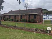
50 Fifth Av Rossmoyne
Pallotine Training Centre, St Vincent Palloti
Rossmoyne Pallottine Aboriginal Hostel
Canning
Metropolitan
Constructed from 1955
| Type | Status | Date | Documents |
|---|---|---|---|
| (no listings) |
| Type | Status | Date | Documents |
|---|---|---|---|
| RHP - To be assessed | Current | 19 Dec 2008 |
| Type | Status | Date | Grading/Management | |
|---|---|---|---|---|
| Category | ||||
| Local Heritage Survey | Adopted | 14 Jun 2022 | 3 | |
The Pallotine Training Centre demonstrates the relationship between government and religious institutions in carrying out assimilation policies toward Aboriginal people. The place has a strong association with the Pallotine Order and represents the urban city counterpart to its country missions. In particular, the place provided accommodation and care for Aboriginal children from the former Tardun Mission School, which has been recognised with state significance (P1673).
Single storey Red Brick and tiled buildings.
The Pallotine Order specifically catered for the provision of residential care towards country Aboriginal students attending metropolitan schools. The Pallotine Mission Centre in Riverton was originally established in 1955 as a hostel for year 7 boy students transferred from the Pallotine’s Tardun farm centre in Geraldton to attend further education in Perth.
Individual Building or Group
| Epoch | General | Specific |
|---|---|---|
| Present Use | UNKNOWN | UNKNOWN |
| Original Use | RELIGIOUS | Office or Administration Bldg |
| Original Use | RESIDENTIAL | Single storey residence |
| Original Use | RELIGIOUS | Church Hall |
| Original Use | RESIDENTIAL | Institutional Housing |
| Style |
|---|
| Other Style |
| Type | General | Specific |
|---|---|---|
| Wall | BRICK | Common Brick |
| Roof | TILE | Terracotta Tile |
| General | Specific |
|---|---|
| SOCIAL & CIVIC ACTIVITIES | Religion |
| PEOPLE | Aboriginal people |
| SOCIAL & CIVIC ACTIVITIES | Institutions |
This information is provided voluntarily as a public service. The information provided is made available in good faith and is derived from sources believed to be reliable and accurate. However, the information is provided solely on the basis that readers will be responsible for making their own assessment of the matters discussed herein and are advised to verify all relevant representations, statements and information.
Constructed from 1955 to 1986
The Pallottine Mission has heritage significance for the following reasons: It is associated with the Pallottine Family called The Union of Catholic Apostolate, a group of Catholic fathers and lay people, who carry out religious and educational instruction, and have been established in Western Australia since 1901; It has significance to the many Aboriginal young men and women who boarded there while receiving an education in the metropolitan area, who mostly who came from the Kimberley region; and, The Chapel and St Vincent Pallotti Hostel built in 1955 has some aesthetic value as a Late Twentieth Century Perth Regional building. All other buildings on the site are of no significance.
The Pallotine Mission complex consists of a number of buildings ranging in date of construction from 1955 to the 1980s. The Chapel (1955) has dark coloured, face brick walls and a low pitched, tiled roof. Windows are projecting from the walls at an angle. The end that addresses Central Road has a glazed gable. The chapel roof steps down at the north end to the St. Vincent Pallotti Hostel and continues onto the former Villa Maria Hostel (1961) (now accommodation units), built in the same materials. The Pallottine Social Centre (1963) in the north western corner of the site is a painted brick building with a very low pitched metal roof. There is a high stone feature wall along the front. The former Boys Lodge (1974) (now Luemann Lodge) has a tiled mansard roof form. Valentine Lodge (1986) is face brick and tile. Buildings have not been assessed internally.
The Pallottine Fathers are a regional branch of an order originally established in Rome by Vincenz Pallotti (1795-1850). In 1835 Pallotti, recognising the problems and potentials of the Church, called for a new apostolate that had special emphasis on the participation of lay people. This concept was new at the time. The priests and brothers he called together in a community in 1846, known as the Society of the Catholic Apostolate, has more than 2000 members all over the world. The Pallottine priests and brothers came to Australia from Germany in 1901 to pastor to the Aboriginal people of Beagle Bay Mission in the Kimberley. From there they spread to other missions and parishes in Western Australia, and eventually to the Eastern States of Australia. The Pallottine Mission in Tardun opened a boarding school in 1948 before establishing a hostel in 1960 to accommodate boys and girls in dormitories who went to school at the mission. With activities so widely scattered, the Pallottines felt that a centre should be established in Perth. In 1951 a rest and recreation centre for country mission workers was established in Rivervale. In 1955 the centre moved to Fifth Avenue, Rossmoyne with a concept to accommodate boys from Tardun of secondary school age who could take up apprenticeships, or attend nearby Catholic Schools, such as Aquinas (Manning) or St. Francis Xavier High School (East Victoria Park; now Ursula Frayne). Father John Luemmen was relocated from Tardun to be the Mission Superior as well as the local Parish Priest from 1956-1963. At first the centre accommodated boys only and was called the St Vincent Pallotti Hostel. The model proved to be successful so, with the assistance of a Lotteries Commission grant and further financial aid, an extension was built catering for 19 girls, called the Villa Maria Hostel. Seven girls were in residence in 1961, and the unit had a full complement in 1962. In 1963, further funds from Lotteries and the Native Welfare Department enabled for a Social Centre to be built. It was officially opened 15 September 1963, and held activities focused on assimilating the residents into ‘white society’ through dances, films evenings, indoor sports, music lessons, speech lessons and so on. At this time there were 16 boys and 17 girls at the Rossmoyne centre. Additional small extensions were made between 1965 and 1968, with minor alterations to the chapel and administrative block. The next large development was in 1967 when additions were made to allow for 20 more girls. The Senior Girls Building officially opened 10 December 1967, for those who had finished high school and were in training or employment. Since 1968, other improvements of a minor nature have been made, with funds provided variously by the government, the Lotteries Commission and Pallottine sources in Australia and Germany. By 1971 the Pallottines controlled missions at La Grange, Beagle Bay, Lombadina, Balgo Hills, Tardun and Wandering. They also had St Joseph’s Hostel in Derby, and the Departmental hostels at Perth (Oceanview, Cottesloe) and Albany. The Rossmoyne Pallottine Mission accommodated some 70 Aboriginal students and workers and roughly a dozen resident lay workers, assistants and mission workers on leave. Its primary emphasis was on education, and most of its residents attended Catholic colleges in Perth. It was, in effect, a boarding school and Father Luemmen himself recognises this when he commented: ‘…it was called the Pallottine Training Centre – this name was chosen recently by the children because they said they felt ashamed of the name “Mission”. Today, I think if I had the choice, I would call it a college.’ (Wilson & Robinson) In 1971 another Senior Lodge for girls was opened followed by a Junior Boys’ Lodge in 1974. In 1980, the Pallottine Centre at Riverton’s Superintendent was Fr Eddy Weirmarker, who succeeded the recently-retired Rev. Fr J. Luemmen. The Centre accommodated 60 Aboriginal children. In 1986 Valentine Lodge was opened to provide more accommodation. It was named after Brother Valentine Ochseknecht. However, by then more schools and services were available in the Kimberley and Pilbara and Aboriginal students no longer necessarily needed to come to Perth for higher education. By 1990 the Pallottine Mission accommodated only 20 students. The centre switched to serve as accommodation for tertiary students. It was named the Edith Little Centre, named after Edith Little (1938-1975) who started work at the Pallottine Mission in 1955 from the age of 17, after attending the Tardun school. She worked as housekeeper for twenty years. The Edith Little Centre operated for only a few years; closing in late 1994. The Pallottine Mission has now been repurposed as The Epiphany Retreat Centre. It offers facilities for retreats and conferences, as follows: • Chapel • Grounds • Three gathering rooms • Valentine Lodge able to accommodate 14 persons plus self-contained unit for leader/teacher, two gathering rooms, dining room • Luemmen Lodge able to accommodate 20 persons plus self -contained unit for leader/teacher, one large gathering room, dining room, prayer room and library.
Condition - Good Integrity - High Aesthetic Value The Pallottine Mission Chapel has some aesthetic value as a Late Twentieth Century Perth Regional building in an institutional and landscape setting. Historic Values The Pallottine Mission has close associations with the Pallottines and their mission school and agricultural school at Tardun, and their work in the Kimberley that focused on education for Aboriginal children. Social Values The Pallottine Mission is significant to the young Aboriginal men and women who lived at the place, and it represents memories and associations for those for whom it played an important role in their lives. The Pallottine Mission contributes to the local and wider community’s sense of place through its association with both Aboriginal missions and the Catholic Church.
Good
| Reserve | Lot/Location | Plan/Diagram | Vol/Folio |
|---|---|---|---|
| 103 | 099514 | 2183/904 |
| Owner | Category |
|---|---|
| Society Of The Catholic Apostolate Inc | Church Property |
This information is provided voluntarily as a public service. The information provided is made available in good faith and is derived from sources believed to be reliable and accurate. However, the information is provided solely on the basis that readers will be responsible for making their own assessment of the matters discussed herein and are advised to verify all relevant representations, statements and information.
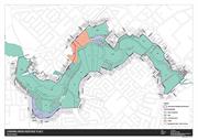
Woodloes St; Fern Rd; Adenia Rd; Riverton Drive; Rssmyn Shelley Rivtn Ferndale Cngtn Wilson
All landholdings and portions thereof that fall within the Canning River Heritage Place Map (included in this Place Record Form). This includes multiple lots and reserves in the ownership of the City of Canning and the Crown between the Shelley Bridge and the Nicholson Road Bridge, and portions within Nos. 1, 3 and 35 Woodloes Street, Cannington, No. 4 Fern Road, Shelley, No. 14 Castledare Place, Wilson, to the extent indicated on the heritage place map.
Canning River
Djarlgarra Beelier (place of abundance)
Dyarlgaard (Noongar country)
Canning
Metropolitan
| Type | Status | Date | Documents |
|---|---|---|---|
| Heritage List | Adopted | 18 Sep 2018 |
| Type | Status | Date | Documents |
|---|---|---|---|
| (no listings) |
| Type | Status | Date | Grading/Management | |
|---|---|---|---|---|
| Category | ||||
| Municipal Inventory | Adopted | 17 Oct 2017 | 1 | |
18987 Swan and Canning Rivers
Large Conservation Region
| Epoch | General | Specific |
|---|---|---|
| Present Use | PARK\RESERVE | Park\Reserve |
| General | Specific |
|---|---|
| DEMOGRAPHIC SETTLEMENT & MOBILITY | Settlements |
This information is provided voluntarily as a public service. The information provided is made available in good faith and is derived from sources believed to be reliable and accurate. However, the information is provided solely on the basis that readers will be responsible for making their own assessment of the matters discussed herein and are advised to verify all relevant representations, statements and information.
Canning River Regional Park has cultural, history and aesthetic heritage significance for the following reasons: The place was used by Aboriginal families for camping, hunting, fishing and as a place for gathering. The place is associated with early European navigation in the area. The place has strong connection to early colonial timber industry, most notably the operation of Mason and Bird. The river continues to be used as a place for community recreation including swimming, fishing, boating and has been an important element in the social fabric of the district. The ecosystem surrounding the Canning River has ability to provide information on native Western Australian flora and fauna. The early use of the river for transportation, including transport associated with the operations of the timber felling industry, has ability to yield substantial archaeological evidence. The place provides a demarcation between fresh and salt water environments in the same river system, it provides avenues for research into requirements and adaptation of river species.
The Canning River Regional Park (CRRP) covers an area of approximately 266 hectares between the Canning River from Nicholson Road Bridge in Cannington to the Shelley Bridge in Rossmoyne. CRRP extends for approximately six kilometres and consists of large areas of parkland for public recreation and extensive wetlands which are reserved for the conservation of flora and fauna. The CRRP runs between two neighbouring areas of the Beeliar and Beeloo Noogars. The river is a rich source of fish, eggs, gilgies, tortoises and plant life within the river as well as its surrounding wetlands. The river contains both salt water and fresh water, and is separated by Kent Street Weir, which contains boards to stop the movement of fish and water from moving upstream. The place contains places considered to be of cultural heritage including The Islands, Masons Landing/Timber Station (1862-1882), Firewood Landing (1880), Sandbag Weir (1911), Firewood landing (1880s), Central Canning Bridge/Nicholson Road Bridge (1885), First Rapid, Brickworks landing (1890’s), Rileys Market Garden (1890-1940), Brickworks (1896), First Riverton Bridge (1910- 1911), Clay Pits, Wharf Street Bathing Ground, Kent Street Weir (1927), Wilson Park/Yankee Yards (1930s), Sikh Cemetery (1932), Second Riverton Bridge (1954), Mounsey’s Footbridge (1960s), Greenfield Street Footbridge (1964), Short Street Bathing Ground.
Prior to colonial settlement, Djarlgarra Beelier (later named Canning River) was used by Aboriginal families for camping, hunting, fishing and as a place for gathering. In 1801, the mouth of the river was discovered by a French exploring party and named Entrée Moreau after Charles Moreau, a midshipman with the party. In March 1827, the river later received its contemporary name by Captain James Stirling, following an examination of the region. The river was named after George Canning (1770-1827), an important British statesman who was Prime Minister of Great Britain at that time. The majority of land along the Canning River was set aside for public use when reserved for landing places were created. The Canning River became an important navigational route during early exploration of the Swan River Colony. Later, the river facilitated the timber industry by connecting the Darling Ranges to Mason’s Landing. Mason’s Landing was established by Benjamin Mason and Francis Bird in 1862. Timber was originally cut and loaded at the river on River Street and taken to its barge further downstream to Fremantle. Other landing places, such as the Brickworks in Riverton in 1896, were established along the river wherever suitable conditions existed which became a community facility for both economical and leisure purposes. The introduction of rail and improved roads later made transport along the river uneconomical due to the time taken to load and unload barges, sometimes having to bypass sections of the river and to the fact that the distance between Cannington and Perth was doubled. The many sand and rock bars also made the river unsuitable for transportation (apart from flat-bottomed boats or barges) and the dredge ‘Black Swan’ was used to prepare channels and keep them clear for barges and steamers. The Canning River became the life and blood of settlers for orchards and industries. In 1911, a weir was constructed near Kent Street out of sand bags to stop salt water from affecting agricultural land upstream. The weir also became a focus for recreational activity on the river in the inter-war years, providing deep water pools for swimming and good fishing spots. Unfortunately for the Canning River, the opening of the Canning Dam in 1933 reduced the flow therefore changed the character of the river. The Mounsey family had a dairy farm opposite Mason Street which went back to Menzies Street. Mr. Mounsey built a 44 gallon drum pontoon with an overhead wire for people to use during times of the year when the river flooded. Mr. Mounsey later built a rickety bridge referred to as Mounsey’s Bridge. Mounsey’s Bridge no longer exists and pedestrian access across this section of the river is maintained by a concrete footbridge that was built in 1964. By the 1960s other previously popular swimming places in the river had deteriorated, and the pool at the weir had become virtually the only public swimming facility in the district. In the 1970s, a reclamation scheme was implemented by the Canning Shire, particularly around the Shelley area. Throughout this time, there was also a significant growth of unknown weed clogging in the freshwater reaches above Kent Street Weir. This growth was suspected to be caused from fish tanks being emptied into drains reaching the river, and nutrients leaching into the river from fertilisers used on home gardens. Whilst many of its original uses such as transportation and swimming are lost, the Canning River today remains as a place for predominantly boating, kayaking and fishing. Historic Values: The place has historically been used by the local Noongar population for hunting, fishing and seasonal settlement. The place represents the use of the River by early Europeans for exploration and navigation of the district. The place has a strong association with the European settlement in the area particularly connected to the timber industry and recreation.
Integrity - High Authenticity - Moderate
Good
| Ref ID No | Ref Name | Ref Source | Ref Date |
|---|---|---|---|
| F Carden | Along The Canning | 1991 | |
| O Richards | Canning River Regional park: Historical Survey | 1991 | |
| A Buchanan / R Dalais | Canning River Stories | 2012 |
| Reserve | Lot/Location | Plan/Diagram | Vol/Folio |
|---|---|---|---|
| 310 | 47439 | 3151/540 |
| Owner | Category |
|---|---|
| Various | UNKNOWN |
This information is provided voluntarily as a public service. The information provided is made available in good faith and is derived from sources believed to be reliable and accurate. However, the information is provided solely on the basis that readers will be responsible for making their own assessment of the matters discussed herein and are advised to verify all relevant representations, statements and information.
154 Hill View Tce St James
Canning
Metropolitan
Constructed from 1956
| Type | Status | Date | Documents |
|---|---|---|---|
| (no listings) |
| Type | Status | Date | Documents |
|---|---|---|---|
| RHP - Does not warrant assessment | Current | 27 Oct 2017 |
| Type | Status | Date | Grading/Management | |
|---|---|---|---|---|
| Category | ||||
| (no listings) | ||||
The place represents the provision of rental housing by the State and Commonwealth governments after World War Two; The place is indicative of the standard plan and type of housing constructed by the State Government in the twentieth-century; The place is an example of the second wave of State Housing construction in the City of Stirling following the end of World War Two; the place has contributory value to a group of residences dating to the 1950s/1960s phase of construction of State Housing Commission residences in the metropolitan area.
This property was constructed in 1956 and is a double brick and tile construction. It is a standard two bedroom property, and has an old style bathroom, laundry and toilet with asbestos lining to the rear enclosed verandah and external soffit linings.
Although the Victoria Park local government area was established in 1894, in 1917 it was incorporated into the Perth City Council. During the 1994 restructure of the Council, Victoria Park again became an independent municipality and resumed the majority of its original expanse. The suburb of St James is partially located with the City of Canning and Town of Victoria Park. House, 154 Hill View Terrace, St James is located within City of Canning. By June 1956, 12,113 homes had been built under the Commonwealth-State Housing Agreement, including 296 in the area known as Millen, later East Victoria Park/St James. The Commonwealth-State Rental Housing Agreement Act 1945 expired in 1956 and was replaced by the Housing Agreement Act 1956 and the State Housing Commission continued to construct houses in the St James area. The Thematic History of Government Housing in Western Australia noted that in 2014, there were 30 Department of Housing places located in St James constructed in the 1956 to 1965 period. A large number of these are located in close proximity to each other, including groups on Berwick Street, Beaconsfield Street and Upton Street. House, 154 Hill View Terrace, St James appears to have been used for the purpose of social housing since its construction. In September 2015 the place is vacant.
Poor
Individual Building or Group
| Epoch | General | Specific |
|---|---|---|
| Present Use | VACANT\UNUSED | Vacant\Unused |
| Original Use | RESIDENTIAL | Single storey residence |
| Style |
|---|
| Vernacular |
| Type | General | Specific |
|---|---|---|
| Roof | TILE | Cement Tile |
| Wall | BRICK | Common Brick |
| Other | STONE | Limestone |
| General | Specific |
|---|---|
| DEMOGRAPHIC SETTLEMENT & MOBILITY | Government policy |
This information is provided voluntarily as a public service. The information provided is made available in good faith and is derived from sources believed to be reliable and accurate. However, the information is provided solely on the basis that readers will be responsible for making their own assessment of the matters discussed herein and are advised to verify all relevant representations, statements and information.
Various
Swan Canning Riverpark
Perth
Metropolitan
| Type | Status | Date | Documents |
|---|---|---|---|
| (no listings) |
| Type | Status | Date | Documents |
|---|---|---|---|
| RHP - To be assessed | Current | 24 Sep 2010 |
| Type | Status | Date | Grading/Management | |
|---|---|---|---|---|
| Category | ||||
| (no listings) | ||||
The place is one of the most prominent landmark in the State of Western Australia
The place has an exceptional level of aesthetic value
The place is highly significant as the primary water way through the Perth metropolitan area and, being the focus of the earliest settlements in the State, still retains numerous sites and places that provide evidence for this story
The place is highly significant to the Western Australian Noongar population as a focus point for ceremony, spiritual life and subsistence during both prehistory through to the present day
The place has long been the focus of recreation and community life in the metropolitan area and has iconic values as the centrepiece of the State
The Swan Canning Riverpark covers 72.1 square kilometres of river reserve and adjoining public lands. The Swan Canning Riverpark supports a diverse array of plant and animal life, some endemic to the region. The Swan and Canning rivers, which stretch and snake their way for 280 kilometres from Wickepin to the deep blue of the Indian Ocean in Fremantle, represent an important slice of West Australian history, as well as holding significant cultural values for Perth, serving as an important feature of the city’s landscape.
The Swan River runs through the Perth metropolitan area from its mouth at Fremantle to Walyunga National Park in the northeast. The Canning River, diverting from the Swan at Canning Bridge, continues to Araluen in the southeast.
The Indigenous population of Western Australia, in the metropolitan area comprising the Noongar language group, utilised the resources of the Swan River for thousands of years prior to European settlement. Although the resources it contained were integral to this focus, the rivers were also significant components in Noongar spiritual and ceremonial life. This focus, and the spiritual links, continues to the present day. Although explored by the French and Dutch during the seventeenth, and early nineteenth centuries, the first British expedition to explore this part of Western Australia did not take place until 1827. Captain James Stirling arrived on the western side of the continent in the H.M.S Success in March and his reports of the region were favourable. The Canning River was also explored during this expedition with Stirling naming it after George Canning, a British Statesman and Prime Minister of Great Britain. Stirling’s favourable reports encouraged the establishment of the Swan River Colony in February 1829. European settlement initially centred around the mouth of the Swan at Fremantle and spread out towards Perth and Guildford. Long thin ribbon grants were allotted to early settlers in the Swan District to give them equal river frontage but poor soils and a noxious weed resulted in movement further east into the Swan Valley. With the introduction of convicts to the Swan River Colony in the 1850s infrastructure building and the availability of a labour force allowed the river valleys to be fully exploited for agriculture. With the commencement of Western Australia’s gold rush in the 1890s the population increased, as did the settlement focus on the Swan and Canning Rivers. This continued throughout the early twentieth century with the majority of the population living in and around the river park and along the coastal areas of the State. The intensive infrastructure building seen during this period saw the construction of a safe harbour at the mouth of the Swan in Fremantle and, during the early twentieth century, large sections of the river along the Perth foreshore were subject to reclamation. The Swan and Canning Rivers have, from the earliest period of settlement, been a focus of Western Australian life. This continues to the present and will continue far into the foreseeable future.
| Library Id | Title | Medium | Year Of Publication |
|---|---|---|---|
| 9531 | Swan and Helena rivers management framework: heritage audit and statement of significance, final report 26 February 2009. | Heritage Study {Other} | 2009 |
Large Conservation Region
| Epoch | General | Specific |
|---|---|---|
| Present Use | Transport\Communications | Water: Other |
| Present Use | SOCIAL\RECREATIONAL | Other |
| Original Use | Transport\Communications | Water: Other |
| General | Specific |
|---|---|
| SOCIAL & CIVIC ACTIVITIES | Sport, recreation & entertainment |
| TRANSPORT & COMMUNICATIONS | River & sea transport |
| DEMOGRAPHIC SETTLEMENT & MOBILITY | Land allocation & subdivision |
| OCCUPATIONS | Commercial & service industries |
| DEMOGRAPHIC SETTLEMENT & MOBILITY | Aboriginal Occupation |
| DEMOGRAPHIC SETTLEMENT & MOBILITY | Exploration & surveying |
This information is provided voluntarily as a public service. The information provided is made available in good faith and is derived from sources believed to be reliable and accurate. However, the information is provided solely on the basis that readers will be responsible for making their own assessment of the matters discussed herein and are advised to verify all relevant representations, statements and information.
9-11 Adams Dr Welshpool
Chambeerlains Tractors
Reidoz
Small Arms Ammunition Factory No 6 (MW)
Canning
Metropolitan
| Type | Status | Date | Documents |
|---|---|---|---|
| (no listings) |
| Type | Status | Date | Documents |
|---|---|---|---|
| (no listings) |
| Type | Status | Date | Grading/Management | |
|---|---|---|---|---|
| Category | ||||
| Municipal Inventory | Adopted | 17 Oct 2017 | 4 | |
Individual Building or Group
| Epoch | General | Specific |
|---|---|---|
| Present Use | INDUSTRIAL\MANUFACTURING | Other |
| Original Use | INDUSTRIAL\MANUFACTURING | Other |
| Style |
|---|
| Other Style |
| Type | General | Specific |
|---|---|---|
| Roof | METAL | Corrugated Iron |
| Wall | METAL | Other Metal |
| General | Specific |
|---|---|
| OCCUPATIONS | Manufacturing & processing |
This information is provided voluntarily as a public service. The information provided is made available in good faith and is derived from sources believed to be reliable and accurate. However, the information is provided solely on the basis that readers will be responsible for making their own assessment of the matters discussed herein and are advised to verify all relevant representations, statements and information.
Constructed from 1942
Welshpool Munitions Factory (fmr), including a factory building with corrugated roof (1942), has cultural heritage significance for the following reasons: The place is associated with the manufacturing of ammunition and its association with the military during World War Two; The place represents an example of factory buildings in the State, and contains several important items of equipment from the early period of operation; The place provided much needed employment during the post war years, including immigrants; The place was important as a site for tractor manufacturing which assisted the Western Australia’s agricultural industry; and The place has significance with its relation to the establishment of Chamberlain John Deere, being a worldwide agricultural machinery corporation.
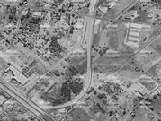
The former munitions factory site was built on a circular shaped site which loops from Welshpool Road to the southwest to Tomlinson Road to the southeast. The site has been subdivided into various lots and only one original building of the former munitions factory remains to date, being located on 9 Adams Drive, Welshpool. The original factory building which remains is constructed of corrugated roof with gabled ends and custom orb sheeting to each elevation and remains as a factory for the metal fabrication purposes.
A plan was established in August 1939 for the expansion of native ordnance production in the threat that war may cut Australia off from the rest of the Commonwealth. Six small arms munitions factories were later built around the country, with the sixth and last factory being built in 1942 in Welshpool. The Welshpool munitions factory operated between 1942 and 1945, and was named Small Arms Ammunition Factory No.6 (MW) which manufactured .303 rifle ammunition. After its closure, the old munitions factory became available in 1947 for use by private industry and was offered by the government to the Chamberlain family. Chamberlain Industries Pty Ltd converted the former munitions factory to manufacture and market agricultural tractors and implements. On 18 May, 1949, the first Chamberlain tractors rolled off the assembly line at Welshpool. These tractors produced were 40k models, containing 40 horsepower kerosene fuelled, twin cylinder, horizontally opposed engines. They weighed about four tonnes and were ideal for the needs of Australian farmers of that era. In 1952, the family began producing implements with the all-welded Chamberlain scarifier, followed a year later by the first Chamberlain disk plough. The need for specialised seeding equipment saw the introduction of the Chamberlain combine seeder in 1963. In 1955, the kerosene tractors gave way to the diesel models. Chamberlain products were commanding wide acceptance in Australian farming and export markets, culminating in the 1964 Export Award, and produced about 25 per cent of the 13,000 tractors bought in Australia each year. To meet the rapidly increasing demands for product, a comprehensive $3.5 million expansion and refit plan was undertaken in 1978. The Welshpool manufacturing site had been completely redeveloped and a new office complex built by the end of 1982. The redevelopment included a fully mechanized Furan moulding line, replacing 6 conventional green sand pinstrips and four green sand roll-over machines, and two new 4.5 tonne electric arc furnaces and a 6 tonne induction holding furnace. In the late 1970s and early 1980s, the complete tractor manufacturing site had a total of 1500 employees, with most being immigrant workers. The rural downturn of the 1980s significantly reduced the farm equipment market and in 1986, the manufacture of the famous tractors ceased. During the downturn, a merger was negotiated with Deere & Company, now based in Illinois, doing business in more than 160 countries and globally employing about 37,000 people. In 1991, Bradken, a cast and prefabricated manufacturing company, moved into the former Chamberlain’s factory site, and operated until its closure in 20066 . In turn, the former Chamberlain’s site was subdivided and only a portion of the original munitions factory workshop remains to date.
Low
Poor
| Reserve | Lot/Location | Plan/Diagram | Vol/Folio |
|---|---|---|---|
| 26 | D86604 | 2025/574 |
This information is provided voluntarily as a public service. The information provided is made available in good faith and is derived from sources believed to be reliable and accurate. However, the information is provided solely on the basis that readers will be responsible for making their own assessment of the matters discussed herein and are advised to verify all relevant representations, statements and information.
380 Welshpool R d Welshpool
Canning
Metropolitan
Constructed from 1991
| Type | Status | Date | Documents |
|---|---|---|---|
| (no listings) |
| Type | Status | Date | Documents |
|---|---|---|---|
| (no listings) |
| Type | Status | Date | Grading/Management | |
|---|---|---|---|---|
| Category | ||||
| Fire & Rescue Service Heritage Inventory | Adopted | 30 Aug 1997 | ||
Individual Building or Group
| Epoch | General | Specific |
|---|---|---|
| Original Use | GOVERNMENTAL | Fire Station |
| Present Use | GOVERNMENTAL | Fire Station |
| General | Specific |
|---|---|
| SOCIAL & CIVIC ACTIVITIES | Community services & utilities |
This information is provided voluntarily as a public service. The information provided is made available in good faith and is derived from sources believed to be reliable and accurate. However, the information is provided solely on the basis that readers will be responsible for making their own assessment of the matters discussed herein and are advised to verify all relevant representations, statements and information.
151 Welshpool Rd Welshpool
Canning
Metropolitan
| Type | Status | Date | Documents |
|---|---|---|---|
| (no listings) |
| Type | Status | Date | Documents |
|---|---|---|---|
| RHP - Does not warrant assessment | Current | 13 Sep 2019 |
| Type | Status | Date | Grading/Management | |
|---|---|---|---|---|
| Category | ||||
| Municipal Inventory | Adopted | 17 Oct 2017 | 5 | |
Historic Site
| Epoch | General | Specific |
|---|---|---|
| Original Use | Transport\Communications | Rail: Other |
This information is provided voluntarily as a public service. The information provided is made available in good faith and is derived from sources believed to be reliable and accurate. However, the information is provided solely on the basis that readers will be responsible for making their own assessment of the matters discussed herein and are advised to verify all relevant representations, statements and information.
Constructed from 1967
The Welshpool-Kewdale Link (fmr), represents the development of the South Western Railway system. The site represents the development of rail transport for mail services and demonstrates associations with commercial and industry services of the town.
Originally, the Welshpool to Kewdale link consisted of a short link which was connected from a Welshpool sliding of the Armadale line, and curved to a freight and parcel depot in Kewdale. After its closure in 1989, the former railway line has been removed and the site has been partially redeveloped as a bus depot, managed by the Public Transport Authority.
The South Western Railway Line was constructed in May 1893 and ran between East Perth and Armadale. Since its opening, a number of private sidings were constructed which included a government operated parcel depot at Welshpool and Rivervale. During the 1950’s the Railway Department proposed to move the extensive Perth Goods depot from Wellington Street to new facilities at Welshpool. Some land was acquired in 1958 for this purpose, however, the signing of the standard gauge contracts put a hold on these plans. The new Forrestfield facility included large marshalling yards and extended to Kewdale where a vast new freight and parcels depot was built. The long circuitous route for shunt trains to Welshpool and Rivervale from Forrestfield, via Woodbridge and Perth was not practical, and a new railway from Kewdale to Welshpool was constructed. This short link from the Kewdale sidings to Welshpool was through open paddocks and presented little problem in the way of earthworks (An alternative proposal to link up with Cannington station was designed and resumptions were carried out on this alignment also). The route was opened on 12 April 1967. The twice daily shunt trains could then run from Kewdale to Welshpool, Carlisle and Rivervale in a fraction of the time and with no disruption to passenger servicers on the Perth-Midland line. In 1982, Westrail commenced a joint venture with Total West and ceased transporting parcels and small freight items. Following the closure of the depots at Welshpool and Rivervale, only the private sidings on the Perth to Armadale line to the cement works in Rivervale and the stockfeeds at Welshpool remained. These sidings were eventually closed as the owners opted for roads transport and the Welshpool-Kewdale railway was closed in March 1989 and the rails later removed1. Today, the former railway line site has been partially redeveloped as a bus depot, managed by the Public Transport Authority. The portion of the former railway link to the north of Orrong Road is now located within the municipality of the City of Belmont.
Low
Poor
| Reserve | Lot/Location | Plan/Diagram | Vol/Folio |
|---|---|---|---|
| 300 | 405510 65589 | LR3166988 2803499 |
| Owner | Category |
|---|---|
| State of Western Australia | State Gov't |
This information is provided voluntarily as a public service. The information provided is made available in good faith and is derived from sources believed to be reliable and accurate. However, the information is provided solely on the basis that readers will be responsible for making their own assessment of the matters discussed herein and are advised to verify all relevant representations, statements and information.
69 Welshpool Rd Welshpool
Near the junction of Railway Pde
Canning
Metropolitan
| Type | Status | Date | Documents |
|---|---|---|---|
| (no listings) |
| Type | Status | Date | Documents |
|---|---|---|---|
| RHP - Does not warrant assessment | Current | 29 Apr 2016 |
| Type | Status | Date | Grading/Management | |
|---|---|---|---|---|
| Category | ||||
| (no listings) | ||||
• Waste Water Pumping Station, Welshpool is unique in Western Australia as the only pumping station specifically created for a Commonwealth munitions factory.
• The construction of critical infrastructure such as Waste Water Pumping Station, Welshpool is associated with the development of Welshpool as a modern industrial area following WWII
• Waste Water Pumping Station, Welshpool is a modest, representative example of a pumping station constructed in the 1930s through to the 1950s
The place is a painted brick building with a shallow pitched tile roof, below-ground pumps and an open-pit overflow sump. An embossed inscription on the side reads: “1942 MWS” [Metropolitan Water Supply]. An internal condition assessment of the concrete walls shows that the wet well appears to be severely corroded. The outer brick wall shows evidence of water infiltration and dislodged bricks. The pump station has various cracks in the walls and floors suggesting the structural integrity may be compromised. Viewed from ground level looking down, the inside wall of the well appears to be bowed or deformed.
Welshpool remained a primarily rural suburb, with some light industry along Welshpool Road, until World War II necessitated the erection of military industrial complexes, sufficiently far from the CBD for safety, yet close enough to major transport routes to be useful. When Japan opened the Pacific War in December 1941, there was a risk Australia could be isolated from sources of supply and so had to create facilities for the production of weapons and ammunition.
Individual Building or Group
| Epoch | General | Specific |
|---|---|---|
| Original Use | GOVERNMENTAL | Pumping Station |
| Present Use | GOVERNMENTAL | Pumping Station |
| Type | General | Specific |
|---|---|---|
| Roof | TILE | Terracotta Tile |
| Wall | BRICK | Common Brick |
This information is provided voluntarily as a public service. The information provided is made available in good faith and is derived from sources believed to be reliable and accurate. However, the information is provided solely on the basis that readers will be responsible for making their own assessment of the matters discussed herein and are advised to verify all relevant representations, statements and information.
6-8 Aveley St Willetton
Glennon Park
"Futuro" Home of the future
Canning
Metropolitan
Constructed from 1975
| Type | Status | Date | Documents |
|---|---|---|---|
| (no listings) |
| Type | Status | Date | Documents |
|---|---|---|---|
| (no listings) |
| Type | Status | Date | Grading/Management | |
|---|---|---|---|---|
| Category | ||||
| Municipal Inventory | Adopted | 08 Aug 1995 | 4 | |
Other Built Type
| Epoch | General | Specific |
|---|---|---|
| Original Use | OTHER | Other |
| Present Use | OTHER | Other |
| Type | General | Specific |
|---|---|---|
| Other | OTHER | Other Material |
| General | Specific |
|---|---|
| DEMOGRAPHIC SETTLEMENT & MOBILITY | Land allocation & subdivision |
This information is provided voluntarily as a public service. The information provided is made available in good faith and is derived from sources believed to be reliable and accurate. However, the information is provided solely on the basis that readers will be responsible for making their own assessment of the matters discussed herein and are advised to verify all relevant representations, statements and information.
Constructed from 1975, Constructed from 1971
Futuro, home of the future is of local significance to the City of Canning as a remnant of the subdivision and sales promotion of the Burrendah area. Its unusual shape make it a significant landmark in the area.
The "spaceship" previously located in Glennon Park, Willetton was originally imported from Scandinavia where it was produecd as a home suitable for construction in remote areas. It was erected in Apsley Road and used to advertise the residential subdivision of Burrendah. It was known as Futuro home of the future, was constructed of fibreglass at a cost of $15,000 and contained a kitchen, bathroom, livingroom and bedroom. It was erected by the agents for the subdivision, Development Underwriting W.A. Pty Ltd. In 1975 the agents attempted to relocate Futuro and in the process it fell over into a pond and sustained $9,000 worth of damage. Futuro was subsequently erected in Glennon Park. (The Sunday Times 16/5/1971 and The West Australian 5/7/1975)
| Ref ID No | Ref Name | Ref Source | Ref Date |
|---|---|---|---|
| "The Sunday Times". | 16/5/1971 | ||
| "The West Australian". | 5/7/1975 |
| Owner | Category |
|---|---|
| City of Canning | Local Gov't |
This information is provided voluntarily as a public service. The information provided is made available in good faith and is derived from sources believed to be reliable and accurate. However, the information is provided solely on the basis that readers will be responsible for making their own assessment of the matters discussed herein and are advised to verify all relevant representations, statements and information.
39 Burrendah Bvd Willetton
Lot 106 on Diagram 54694
Nandos
National Australia Bank (fmr)
Canning
Metropolitan
| Type | Status | Date | Documents |
|---|---|---|---|
| (no listings) |
| Type | Status | Date | Documents |
|---|---|---|---|
| (no listings) |
| Type | Status | Date | Grading/Management | |
|---|---|---|---|---|
| Category | ||||
| Municipal Inventory | Adopted | 17 Oct 2017 | 5 | |
Individual Building or Group
| Epoch | General | Specific |
|---|---|---|
| Original Use | GOVERNMENTAL | Other |
| Present Use | COMMERCIAL | Shop\Retail Store {single} |
| Style |
|---|
| Late 20th-Century Late Modern |
| Type | General | Specific |
|---|---|---|
| Roof | CONCRETE | Concrete Slab |
| Wall | BRICK | Face Brick |
| Other | METAL | Other Metal |
| General | Specific |
|---|---|
| TRANSPORT & COMMUNICATIONS | Mail services |
This information is provided voluntarily as a public service. The information provided is made available in good faith and is derived from sources believed to be reliable and accurate. However, the information is provided solely on the basis that readers will be responsible for making their own assessment of the matters discussed herein and are advised to verify all relevant representations, statements and information.
Constructed from 1979 to 1980
Willetton Post Office is a site connected with the postal and telecommunication needs of the growing Willetton population in the late 20th Century.
The Willetton Post Office (fmr) is a single storey, rectangular brick building with a flat roof above. The place originally contained a mail sorting area to the rear with roller doors, and contained a series of post boxes and decorative brick face to the western elevation. The original entrance is now screened from the streetscape by a take away food tenancy to the southeast and contains an incorporated alfresco area fronting Burrendah Boulevard, and internal fitout throughout. The original post boxes on the southeast elevation have been replaced with glazing, however the original brick façade, and awnings to the northeast and southeast elevations with brick posts remain.
According to historical aerial imagery, Willetton Post Office was constructed between 1979 and 1980, following the construction of Southlands Boulevard Shopping Centre which is located to the southwest of the post office. The place operated under Australia Postal Corporation (Australia Post) as a functional standalone post office. Between 1983 and 1985, a service building was constructed to the rear to facilitate the operations of the post office. In 1896, an addition to the service building was installed which included a new room and new sliding windows. There is some anecdotal evidence to suggest the pay phones located in this site were very well used by the community until mobile devices become more prominent. Subsequent to changing technologies and to the mail handling system, many stand- alone post office buildings were no longer considered suitable for postal services and where instead, leased out by Australia Post on commercial terms to external businesses and organisation7. Similarly, in 1993, internal and external works were carried out to the building including the construction of a new bank tenancy to the northern balance of the building, and the demolition of the service building to the rear. The bank tenancy was let out as a National Australia Bank branch. In 1994, approval was granted for a new commercial building over the adjacent lot, which was constructed to directly block the main entrance of the original post office building from the streetscape. In 2007, internal alterations and additions for the National Australia Bank branch was carried out toward the northern balance of the former post office building which significantly altered the internal building fabric of the building, and included a new fascia to the south and east elevation. In 2014, the place was later leased out as a restaurant and take away food outlet, operating as Nando’s which remains to date. Internal and external alterations to the building were carried out at the time of its occupation.
Low
Good
| Ref ID No | Ref Name | Ref Source | Ref Date |
|---|---|---|---|
| Australia Post | https://auspost.com.au/about-us/corporate-information/history-heritage |
| Reserve | Lot/Location | Plan/Diagram | Vol/Folio |
|---|---|---|---|
| 106 | D54694 | 2140/685 |
This information is provided voluntarily as a public service. The information provided is made available in good faith and is derived from sources believed to be reliable and accurate. However, the information is provided solely on the basis that readers will be responsible for making their own assessment of the matters discussed herein and are advised to verify all relevant representations, statements and information.
Cnr Willeri Dve & Collins Rd Willetton
Canning
Metropolitan
| Type | Status | Date | Documents |
|---|---|---|---|
| (no listings) |
| Type | Status | Date | Documents |
|---|---|---|---|
| (no listings) |
| Type | Status | Date | Grading/Management | |
|---|---|---|---|---|
| Category | ||||
| (no listings) | ||||
Individual Building or Group
| Epoch | General | Specific |
|---|---|---|
| Present Use | RESIDENTIAL | Single storey residence |
| Original Use | RESIDENTIAL | Single storey residence |
This information is provided voluntarily as a public service. The information provided is made available in good faith and is derived from sources believed to be reliable and accurate. However, the information is provided solely on the basis that readers will be responsible for making their own assessment of the matters discussed herein and are advised to verify all relevant representations, statements and information.
8 Farleigh Dr Willetton
Canning
Metropolitan
Constructed from 1980
| Type | Status | Date | Documents |
|---|---|---|---|
| (no listings) |
| Type | Status | Date | Documents |
|---|---|---|---|
| (no listings) |
| Type | Status | Date | Grading/Management | |
|---|---|---|---|---|
| Category | ||||
| Anglican Church Inventory | YES | 31 Jul 1996 | ||
Individual Building or Group
| Epoch | General | Specific |
|---|---|---|
| Original Use | RELIGIOUS | Housing or Quarters |
| Type | General | Specific |
|---|---|---|
| Wall | BRICK | Common Brick |
| Roof | TILE | Cement Tile |
| General | Specific |
|---|---|
| SOCIAL & CIVIC ACTIVITIES | Religion |
This information is provided voluntarily as a public service. The information provided is made available in good faith and is derived from sources believed to be reliable and accurate. However, the information is provided solely on the basis that readers will be responsible for making their own assessment of the matters discussed herein and are advised to verify all relevant representations, statements and information.
Cnr Glenkerry/Killara/Gerber Sts Willetton
Canning
Metropolitan
Constructed from 1995
| Type | Status | Date | Documents |
|---|---|---|---|
| (no listings) |
| Type | Status | Date | Documents |
|---|---|---|---|
| (no listings) |
| Type | Status | Date | Grading/Management | |
|---|---|---|---|---|
| Category | ||||
| Anglican Church Inventory | YES | 31 Jul 1996 | ||
Individual Building or Group
| Epoch | General | Specific |
|---|---|---|
| Original Use | RELIGIOUS | Church, Cathedral or Chapel |
| Present Use | RELIGIOUS | Church, Cathedral or Chapel |
| Type | General | Specific |
|---|---|---|
| Roof | METAL | Corrugated Iron |
| Wall | BRICK | Common Brick |
| General | Specific |
|---|---|
| SOCIAL & CIVIC ACTIVITIES | Religion |
This information is provided voluntarily as a public service. The information provided is made available in good faith and is derived from sources believed to be reliable and accurate. However, the information is provided solely on the basis that readers will be responsible for making their own assessment of the matters discussed herein and are advised to verify all relevant representations, statements and information.
14-16 Herald Av Willetton
Canning
Metropolitan
Constructed from 1974, Constructed from 1984
| Type | Status | Date | Documents |
|---|---|---|---|
| (no listings) |
| Type | Status | Date | Documents |
|---|---|---|---|
| (no listings) |
| Type | Status | Date | Grading/Management | |
|---|---|---|---|---|
| Category | ||||
| Uniting Church Inventory | Completed | 01 Oct 1996 | ||
Individual Building or Group
| Epoch | General | Specific |
|---|---|---|
| Original Use | RELIGIOUS | Church, Cathedral or Chapel |
| Present Use | RELIGIOUS | Church, Cathedral or Chapel |
| Type | General | Specific |
|---|---|---|
| Roof | TILE | Ceramic Tile |
| Wall | BRICK | Common Brick |
| General | Specific |
|---|---|
| SOCIAL & CIVIC ACTIVITIES | Religion |
This information is provided voluntarily as a public service. The information provided is made available in good faith and is derived from sources believed to be reliable and accurate. However, the information is provided solely on the basis that readers will be responsible for making their own assessment of the matters discussed herein and are advised to verify all relevant representations, statements and information.