Local Government
Carnarvon
Region
Gascoyne
Annear Pl Babbage Island
Annear Place, Babbage Island
Carnarvon
Gascoyne
| Type | Status | Date | Documents |
|---|---|---|---|
| Heritage List | Adopted | 23 Jun 2015 |
| Type | Status | Date | Documents |
|---|---|---|---|
| (no listings) |
| Type | Status | Date | Grading/Management | |
|---|---|---|---|---|
| Category | ||||
| Municipal Inventory | Adopted | 23 Jun 2015 | Category 2 | |
00462 Carnarvon Lighthouse Keeper’s Cottage (fmr) [Babbage Island Lighthouse]
Historic site
This information is provided voluntarily as a public service. The information provided is made available in good faith and is derived from sources believed to be reliable and accurate. However, the information is provided solely on the basis that readers will be responsible for making their own assessment of the matters discussed herein and are advised to verify all relevant representations, statements and information.

Constructed from 1896, Constructed from 1962
00462 Carnarvon Lighthouse Keeper’s Cottage (fmr) [Babbage Island Lighthouse]
Aesthetic Value – Importance for the aesthetic character created by the individual components that collectively form a significant precinct. Historic Value – Importance in relation to an event, phase or activity of historic importance in the locality. Social Value – Importance in contributing to a community’s sense of place.
The original 1896 wooden tower was damaged by fire and was replaced by the present steel skeletal tower in 1962. The lantern in now on display on the grounds near the tower.
A wooden tower 60 feet high on a site 42 feet above sea level, held a fourth order dioptric light visible at 15 miles in good conditions. It was developed by the Northwest Branch of the Public Works Department with the lantern house and light supplied by the firm of W.T. Douglas. It was converted from paraffin (kerosene) oil to acetylene illumination in 1909, and it carried in 1913, two red sector lights flashing every 3 seconds, one visible on a bearing 015-041o which led west of Blowfish Bank, and a second visible one a bearing 345-031o which led west of Elbow Shoal. This light tower was described in 1922 and in 1948 as a white square (wooden) framework tower 18m high, supported a sectored flashing light at an elevation of 31m. This was replaced by a new light on a steel framework tower in the early 1960s, which was present and working in 1994. The original light is now on exhibition in the grounds of the Lighthouse Keeper’s cottage museum.
Medium/High
Fair
| Reserve | Lot/Location | Plan/Diagram | Vol/Folio |
|---|---|---|---|
| 8952 | |||
| 24107 | 1231 | 216524 |
| Owner | Category |
|---|---|
| Carnarvon Heritage Group | Inc. Non-profit body |
This information is provided voluntarily as a public service. The information provided is made available in good faith and is derived from sources believed to be reliable and accurate. However, the information is provided solely on the basis that readers will be responsible for making their own assessment of the matters discussed herein and are advised to verify all relevant representations, statements and information.
This information is provided voluntarily as a public service. The information provided is made available in good faith and is derived from sources believed to be reliable and accurate. However, the information is provided solely on the basis that readers will be responsible for making their own assessment of the matters discussed herein and are advised to verify all relevant representations, statements and information.
Annear Pl, off Binning Rd Babbage Island
Adjacent to One-Mile Jetty; Lot 1231 on Plan 216524; Reserve 24107; Reserve 8952
Carnarvon Lighthouse
Carnarvon Lighthouse Keeper’s Cottage (fmr)
Lighthouse Keeper's Cottage Museum
Carnarvon
Gascoyne
Constructed from 1897
| Type | Status | Date | Documents |
|---|---|---|---|
| Heritage List | Adopted | 23 Jun 2015 | |
| State Register | Registered | 24 Mar 2000 | HCWebsite.Listing+ListingDocument, HCWebsite.Listing+ListingDocument |
| Type | Status | Date | Documents |
|---|---|---|---|
| (no listings) |
| Type | Status | Date | Grading/Management | |
|---|---|---|---|---|
| Category | ||||
| Municipal Inventory | Adopted | 23 Jun 2015 | Category 1 | |
| Register of the National Estate | Permanent | 18 Apr 1989 | ||
| Classified by the National Trust | Classified | 01 Jun 1989 | ||
| Library Id | Title | Medium | Year Of Publication |
|---|---|---|---|
| 5689 | Carnarvon heritage precinct : structure plan. | Heritage Study {Other} | 2002 |
| 8933 | Carnarvon heritage precinct : structure plan. | Report | 2004 |
| 8934 | Interpertation plan for the Carnarvon heritage precinct Canarvon. Interim report. | Report | 0 |
| 5266 | Conservation plan for Carnarvon Lighthouse Keeper's Cottage (former), Babbage Island, Carnarvon, Western Australia / prepared by John Taylor Architect for the Gascoyne Historical Society. | Heritage Study {Cons'n Plan} | 1997 |
Individual Building or Group
| Epoch | General | Specific |
|---|---|---|
| Present Use | EDUCATIONAL | Museum |
| Original Use | Transport\Communications | Water: Housing or Quarters |
| Style |
|---|
| Federation Bungalow |
| Type | General | Specific |
|---|---|---|
| Wall | TIMBER | Weatherboard |
| Roof | METAL | Corrugated Iron |
| General | Specific |
|---|---|
| TRANSPORT & COMMUNICATIONS | River & sea transport |
This information is provided voluntarily as a public service. The information provided is made available in good faith and is derived from sources believed to be reliable and accurate. However, the information is provided solely on the basis that readers will be responsible for making their own assessment of the matters discussed herein and are advised to verify all relevant representations, statements and information.

Constructed from 1897
Aesthetic Value – Carnarvon Lighthouse Keeper’s Cottage (fmr) constructed in the Federation Bungalow style, has aesthetic value as a very simple cottage built during this period. Aesthetic Value – Carnarvon Lighthouse Keeper’s Cottage (fmr) has landmark quality due to its relationship with the light tower, ‘One Mile Jetty’ and the remains of the Carnarvon Tramway. Aesthetic Value – In association with the light tower (1987), the ‘One Mile Jetty’ (1897-98), and the remains of the Carnarvon Tramway (c.1900s); Carnarvon Lighthouse Keeper’s Cottage (fmr) forms a precinct of turn of the century maritime buildings and structures in Carnarvon. Historic Value – Carnarvon Lighthouse Keeper’s Cottage (fmr) has historical significance as part of a group of structures including the light tower, ‘One Mile Jetty’ and the remains of the Carnarvon tramway, that have played an important part in the development of Carnarvon as a centre of communication and transport for the Gascoyne region. Historic Value – Carnarvon Lighthouse Keeper’s Cottage (fmr) has a close association with the Lighthouse Keepers that have lived in the cottage and maintained the light tower. Their role was important to the development and operation of the port facilities in Carnarvon and the Gascoyne Region of Western Australia. Historic Value – The local Carnarvon community successfully lobbied to save the place from demolition in the 1980s. After restoration works, the place opened as the Lighthouse Keeper’s Cottage Museum during the 1988 Bicentennial celebrations. Social Value – Carnarvon Lighthouse Keeper’s Cottage (fmr) demonstrates part of a distinctive way of life now seldom practised since the introduction of fully automated light mechanisms. Social Value – Carnarvon Lighthouse Keeper’s Cottage (fmr) is highly valued as a museum and tourist destination and contributes to the community’s sense of place. Rarity – Carnarvon Lighthouse Keeper’s Cottage (fmr) demonstrates a distinctive way of life no longer practised in the State since the introduction of fully automated light mechanisms. Representativeness – The design of introduction of fully automated light mechanisms. Is representative of the Federation Bungalow style (c.1890 – c.1915) and a representative example of domestic architecture by the P.W.D.
A gabled roofed building with an encircling broken pitch verandah. The building has five rooms with a central passage. It is located near ‘One Mile’ jetty and the tramway connecting it to the Town of Carnarvon. The port of Carnarvon in the 1890’s was the major port of the Gascoyne region facilitating the transport of wool, cattle and people by coastal steamer.
The Lighthouse Keeper’s Cottage is a simple timber and iron cottage designed by the Public Works Department in 1895 and built in 1896-97 in association with a timber light tower. It is located on Babbage Island near the ‘One Mile Jetty’ and the tramway connecting it to the town of Carnarvon, all built around the same time as major improvements to the port facilities. The shipping of wool, cattle and people by coastal steamer had become big business in the north-west by the 1890s and Carnarvon was the major port to the Gascoyne region. The cottage is a reminder of the days that lighthouses required daily attention and their keepers were housed on site. The quarters consist of a four roomed cottage with a central passage and a verandah all around. The main gable roof and verandahs are sheeted in corrugated iron. Verandah roofs are sealed on the rake with reed moulded lining boards. Ceilings and walls inside are similarly sealed on the rake with reed moulded lining boards. External walls and gable ends are clad in rough weatherboards. These materials are in fair and neat condition. Timber boards to the verandahs still exist but are in poor condition. Floors appear to be supported on tree stumps in some places. The southern verandah has been enclosed and washrooms added to the seaward side of the west verandah. The yard contains a detached toilet and a standard design PWD cistern with its dome above ground level. The last Lighthouse Keeper was in residence in 1980.
Medium/Medium
Good
| Reserve | Lot/Location | Plan/Diagram | Vol/Folio |
|---|---|---|---|
| 24107 | 1231 | 216524 |
| Owner | Category |
|---|---|
| Carnarvon Heritage Group | Inc. Non-profit body |
This information is provided voluntarily as a public service. The information provided is made available in good faith and is derived from sources believed to be reliable and accurate. However, the information is provided solely on the basis that readers will be responsible for making their own assessment of the matters discussed herein and are advised to verify all relevant representations, statements and information.
The light house keeper’s quarters has some significance as a demonstration of a way of life now seldom practised maintaining the isolated light houses on the Western Australian coast. It has historical significance as part of a group of structures including the Light Tower, the ‘mile long’ jetty and the remains of the tramway, that have played an important part in the development of Carnarvon as a part. It is also well preserved but by no means unique example of a timber frame PWD housing at the turn of the century.
The Light House Keeper’s quarters is a simple timber and iron cottage designed by the PWD in 1895 and built in 1896-7 in association with a timber light tower. It is located on Babbage island near the ‘mile long’ stock jetty ad the tramway connecting it to the town of Carnarvon, all built around the same time as major improvements to the port facilities. These replaced the 1880’s jetty and tramway at Mangrove Point that could cater for lighters only. The shipping of wool, cattle and people by coastal steamer had become big business in the northwest by the 1890’s and Carnarvon was the major port to the Gascoyne region. The cottage is a fairly well-preserved example of its type but isnot unique. Finer examples of light keeper’s quarters that are contemporary with this one, still exist on Rottnest Island, at Woodman’s Point and at Capers Leeuwin and Naturalist. These are similar in plan by have hipped roofs and are built of locally quarried stone. They all belong to the days when lighthouses required daily attention and their keepers were housed on site. Most lights are now automatic and only service once or twice a year. The Quarters consist of a four roomed cottage with a central passage and a verandah all round. The main gable roof and verandahs are sheeted in corrugated iron. The main gable roof and verandahs are sheeted in corrugated iron. Verandah roofs are sealed on the rake with reed moulded lining boards. Ceilings and walls inside are similarly lined while external walls and gable ends are clad in rough weatherboard. These materials are in fair and near original condition. Timber boards to the verandahs still exist but are in poor condition. Floors appear to be supported on tree trunk stumps in some places, The southern verandah has been enclosed and washrooms added to the seaward side of the west verandah. The yard contains a detached WC and a standard design PWD cistern with its dome above ground level.
Assessment 1989 for LIGHT HOUSEKEEPERS QUARTERS
This information is provided voluntarily as a public service. The information provided is made available in good faith and is derived from sources believed to be reliable and accurate. However, the information is provided solely on the basis that readers will be responsible for making their own assessment of the matters discussed herein and are advised to verify all relevant representations, statements and information.

Mahony Av Brown Range
Lot 2 on Plan 401280 and Lot 28 on Plan 015963
OTC Earth Station
OTC Telecommunications Station
Overseas Telecommunications Station
The Dish
Carnarvon
Gascoyne
Constructed from 1964 to 1969
| Type | Status | Date | Documents |
|---|---|---|---|
| Heritage List | Adopted | 23 Jun 2015 | |
| Heritage List | Adopted | 26 Feb 1988 | |
| State Register | Registered | 04 May 2001 | HCWebsite.Listing+ListingDocument, HCWebsite.Listing+ListingDocument |
| Type | Status | Date | Documents |
|---|---|---|---|
| (no listings) |
| Type | Status | Date | Grading/Management | |
|---|---|---|---|---|
| Category | ||||
| Register of the National Estate | Indicative Place | |||
| Municipal Inventory | Adopted | 23 Jun 2015 | Category 1 | |
| Name | Type | Year From | Year To |
|---|---|---|---|
| NASA, particularly the Apollo project | Architect | - | - |
| Library Id | Title | Medium | Year Of Publication |
|---|---|---|---|
| 5980 | Conservation plan for OTC Satellite Earth Station (fmr) (1966) : Carnarvon : Western Australia. | Heritage Study {Cons'n Plan} | 2002 |
| 7548 | OTC Satellite Earth Station Carnarvon : Casshorn Dish and Parabolic Dish : conservation works 2005 (final report). | Conservation works report | 2005 |
Historic site
| Epoch | General | Specific |
|---|---|---|
| Present Use | VACANT\UNUSED | Vacant\Unused |
| Original Use | Transport\Communications | Comms: Other |
| Style |
|---|
| Other Style |
| Type | General | Specific |
|---|---|---|
| Other | CONCRETE | Other Concrete |
| Other | METAL | Steel |
| General | Specific |
|---|---|
| TRANSPORT & COMMUNICATIONS | Space exploration |
This information is provided voluntarily as a public service. The information provided is made available in good faith and is derived from sources believed to be reliable and accurate. However, the information is provided solely on the basis that readers will be responsible for making their own assessment of the matters discussed herein and are advised to verify all relevant representations, statements and information.

Constructed from 1966
Aesthetic Value – OTC Satellite Earth Station (fmr) has landmark value as a distinctive part of the Brown’s Range landscape and is a prominent focal point to the area east of the Carnarvon township. Aesthetic Value – The 1960s buildings and structures that comprise OTC Satellite Earth Station (fmr) form a precinct that is identifiable as a satellite earth station. Historic Value – OTC Satellite Earth Station (fmr) is of exceptional historical significance as the first satellite earth station constructed in Australia. Historic Value – OTC Satellite Earth Station (fmr) is significant for its association with the creation of INTELSAT in August 1964, reflecting Australia’s involvement in the establishment of the global communications system (INTELSAT). Historic Value – OTC Satellite Earth Station (fmr) is significant for its association with a number of NASA’s space projects, including the Apollo project which successfully landed the first men on the moon in July 1969. Historic Value – OTC Satellite Earth Station (fmr) is associated with the first live telecasts between Australia and an overseas country. Historic Value – OTC Satellite Earth Station (fmr) is closely associated with the work of OTC, INTELSAT, NASA and ESA organisations. Historic Value – OTC Satellite Earth Station (fmr) is associated with the technical innovation and achievement of creating a global communications system. Research Value – OTC Satellite Earth Station (fmr) holds international significance as a research and teaching site for its ability to illustrate the principal characteristics of the earth stations erected to create a global communications system in 1968. Elements of particular importance include the Cassegrain fed folded horn antenna and the larger OTC parabolic dish. Research Value – OTC Satellite Earth Station (fmr) is significant as an example of technical and innovative advancements in global communication in the 1960s. Social Value – OTC Satellite Earth Station (fmr) holds significant social value to the Carnarvon community as a site of international importance at which many people from the town were employed. Rarity – OTC Satellite Earth Station (fmr) contains a collection of structures that are rare and uncommon in Australia. The place was the first earth station built in Australia by the Overseas Telecommunications Commission and was one of only eight satellite earth stations in the world which carried out the function calling Tracking, Telemetry, Command and Monitoring (TTC&M) Representativeness – OTC Satellite Earth Station (fmr) is characteristic of satellite earth stations located around the world.
Satellite communication dish that formed part of a world-wide network of communication stations. Carnarvon was chosen as the site of the station for its close association and incidental role to the NASA Tracking Station.
On 20 August 1964, Australia along with fourteen other countries, signed two agreements to form an international telecommunications satellite consortium (INTELSAT). The objective was to establish a global communications system by 1968. The Overseas Telecommunications Commission (OTC) was Australia’s representative on the Interim Communications Satellite Committee (ICSC). In 1965, NASA’s Apollo moon landing project proposed a communications satellite network in which two satellites would be launched into orbit. A network of satellite earth stations was also needed to work in conjunction with these satellites. The Carnarvon location was decided upon primarily because of the presence of the NASA Tracking Station. Subsequently the earth station was designed to provide a direct communications link between Australia and the USA as part of the space projects administered by NASA. The OTC Satellite Earth Station (fmr) was established on Brown’s Range in 1966. The site initially comprised of three air-conditioned vans, an administration building, a powerhouse, 12 staff houses and a 12.8m Cassegrain fed folded horn antenna (Casshorn). On 24 November 1966 the first live telecasts occurred between Australia and an overseas country through transmission from the OTC Satellite Earth Station. The OTC Satellite Earth Station was also involved in the Apollo series which operated from October 1968 to December 1972. In 1969, the earth station was upgraded from semi transportable structures to more permanent structures. The Casshorn antenna monitored the performance of satellites while the larger 29.6 metre parabolic dish handled internal communication via the INTELSAT Pacific Ocean Satellite. The ESA antenna played an instrumental role in the 1985/1986 space mission to track the Giotto satellite from its launch up to its interception with Halley’s Comet. The OTC Satellite Earth Station closed in 1987. In 1989, an observatory was constructed at the northern end of the site. The OTC Satellite Earth Station is currently used as a Space and Technology Museum. The listing consists of the single men’s quarters, recreation building including swimming pool, tennis court and playground, administration control building, workshop, powerhouse and fuel shed, 1966 cassegrain fed folded horn antenna (Casshorn) (12.8 metres by 16.5 metres high), 1969 parabolic dish antenna (29.6 metres wide), 1980 ESA dish antenna base (15 metres wide), telemetry antenna support and equipment shelter and the telecommand equipment shelter. The staff quarters (25 houses on Craggs Court) have not been included in this listing. A representation of these houses has been listed separately as Place Record No. 62.
Medium/Medium
Fair
| Reserve | Lot/Location | Plan/Diagram | Vol/Folio |
|---|---|---|---|
| 1 | 047769 | ||
| 2 | 401280 | ||
| 28 | 015963 |
| Owner | Category |
|---|---|
| Wayne Rowe | Other Private |
| Shire of Carnarvon | Local Gov't |
This information is provided voluntarily as a public service. The information provided is made available in good faith and is derived from sources believed to be reliable and accurate. However, the information is provided solely on the basis that readers will be responsible for making their own assessment of the matters discussed herein and are advised to verify all relevant representations, statements and information.

Carnarvon
Carnarvon townsite to the One Mile Jetty
Carnarvon
Gascoyne
Constructed from 1898 to 1959
| Type | Status | Date | Documents |
|---|---|---|---|
| State Register | Registered | 07 Feb 1997 | HCWebsite.Listing+ListingDocument, HCWebsite.Listing+ListingDocument |
| Type | Status | Date | Documents |
|---|---|---|---|
| (no listings) |
| Type | Status | Date | Grading/Management | |
|---|---|---|---|---|
| Category | ||||
| Statewide Lge Timber Str Survey | Completed | 11 Dec 1998 | ||
| Statewide Railway Heritage Surve | Completed | 01 Aug 1994 | ||
| Register of the National Estate | Permanent | 26 Oct 1999 | ||
| Classified by the National Trust | Classified | 08 Jul 1996 | ||
| Name | Type | Year From | Year To |
|---|---|---|---|
| Publics Works Dept | Architect | - | - |
| Library Id | Title | Medium | Year Of Publication |
|---|---|---|---|
| 5689 | Carnarvon heritage precinct : structure plan. | Heritage Study {Other} | 2002 |
| 3421 | Conservation plan for the Carnarvon Tramway. | Heritage Study {Cons'n Plan} | 1995 |
| 519 | Carnarvon. | Book | 1980 |
| 3850 | Carnarvon Heritage Precinct Masterplan | Heritage Study {Other} | 1998 |
| 3670 | Carnarvon Tramway Watertank | Report | 1998 |
| 4558 | Carnarvon heritage precinct : trail development plan. | Heritage Study {Other} | 1999 |
| 8933 | Carnarvon heritage precinct : structure plan. | Report | 2004 |
| 11870 | Conservation plan for the 'One Mile Jetty' Carnarvon | Heritage Study {Cons'n Plan} | 1996 |
| 8934 | Interpertation plan for the Carnarvon heritage precinct Canarvon. Interim report. | Report | 0 |
Individual Building or Group
| Epoch | General | Specific |
|---|---|---|
| Original Use | Transport\Communications | Rail: Other |
| Present Use | Transport\Communications | Water: Jetty |
| Original Use | Transport\Communications | Water: Jetty |
| Style |
|---|
| Other Style |
| Type | General | Specific |
|---|---|---|
| Other | TIMBER | Other Timber |
| General | Specific |
|---|---|
| TRANSPORT & COMMUNICATIONS | River & sea transport |
This information is provided voluntarily as a public service. The information provided is made available in good faith and is derived from sources believed to be reliable and accurate. However, the information is provided solely on the basis that readers will be responsible for making their own assessment of the matters discussed herein and are advised to verify all relevant representations, statements and information.
AESTHETIC VALUE. The bridges and tramway formation add interest to and enliven the 'Fascine' and Babbage & Whitlock Island's landscape. The regular appearance of the weathered piles and timber structure draws the eye as one approaches the 'Town Bridge' from either side on Olivia Terrace, and forms a strong linear image. The 'One Mile Jetty' has a similar aesthetic value. HISTORIC VALUE. The Carnarvon Tramway is of exceptional significance to the history of Carnarvon. It formed an integral part of the working nature of the town for almost one hundred years. It was initially the only major method of import and export of goods to the area - although that role was gradually usurped as the port activities declined with the advent of road transport. In part it dictated the areas of commercial development in the town for many years, and the Carnarvon town plan reflects this influence. SCIENTIFIC VALUE, The 'One Mile Jetty' has scientific value in relation to the study of marine life. SOCIAL VALUE. The Carnarvon Tramway is of extremely high social value for its strong commercial association with Carnarvon and the surrounding regional communities developed over many years; and also its recreational value through fishing, access to beaches, even as a port of departure for holidays in earlier times. The Carnarvon Tramway also contributes to the Carnarvon community's sense of place through its' visual landmark qualities. RARITY. The Carnarvon Tramway is now the most intact example of the former Public Works Department tramways serving coastal Western Australia. It was also the longest of its type. The Tramway is unique in still having restorable original fabric right through from the jetty to the receival points at the town. REPRESENTATIVENESS. The Carnarvon Tramway is of exceptional significance in this criterion. An original working locomotive and tramway formation is in working order. The opportunity exists to provide an interpretative experience for the complete circular process that formed the Tramway Precinct. CONDITION. The Carnarvon Tramway is in reasonable condition. The original fabric has deteriorated over time - particularly since the abandonment of regular maintenance procedures, and some portions (several culvert bridges) have been removed. INTEGRITY. The Carnarvon Tramway has a high degree of integrity. The Place has only ever been used for the original purpose for which it was designed, and thus has had very little in the way of intrusive changes. It has great potential for complete restoration. AUTHENTICITY. The Carnarvon Tramway has a high level of authenticity. All the bridges and the majority of the rolling stock are original Carnarvon Tramway facilities. However the new rail currently being laid (on the original formation) is generally being procured from other sources. Almost all the other fabric exists in its original locations. STATEMENT OF CULTURAL SIGNIFICANCE. The Carnarvon Tramway (the Place) has exceptional cultural heritage significance for the following reasons: • the Place has visual landmark qualities highly valued by the people of Carnarvon and of the Gascoyne Region of Western Australia; • the Place demonstrates a complete circular process developed to cope with and to overcome extreme pioneering transport hardships; • the Place is an integral part of the developmental history of Carnarvon and the Gascoyne Region; • the Place has a strong commercial association and familiarity with the people of Carnarvon and the Gascoyne Region; • the Place is representative of the work of the well-known Contractors Atkins and Law (1899-1900 works); • the Place contains major surviving evidence of turn of the century timber bridge (and jetty) design and construction techniques. • the Place is a valued recreational asset to the community. • the Place is a working and demonstrative example of a process that is in danger of being lost from the State of Western Australia.
Assessment 1995 This assessment refers to the Tramway Precinct in part, and makes particular reference to the items of fabric within the area leased by the Carnarvon Light Railway Association Inc.
This information is provided voluntarily as a public service. The information provided is made available in good faith and is derived from sources believed to be reliable and accurate. However, the information is provided solely on the basis that readers will be responsible for making their own assessment of the matters discussed herein and are advised to verify all relevant representations, statements and information.
Babbage Island Carnarvon
Off Annear Place. Lot 1366 on Plan 033520; Reserve 48229.
Carnarvon Jetty
Mile Long Jetty
Stock Jetty
Carnarvon
Gascoyne
Constructed from 1904
| Type | Status | Date | Documents |
|---|---|---|---|
| Heritage List | Adopted | 23 Jun 2015 |
| Type | Status | Date | Documents |
|---|---|---|---|
| (no listings) |
| Type | Status | Date | Grading/Management | |
|---|---|---|---|---|
| Category | ||||
| Register of the National Estate | Permanent | 26 Oct 1999 | ||
| Classified by the National Trust | Classified | 01 Jun 1989 | ||
| Statewide Lge Timber Str Survey | Completed | 11 Dec 1998 | ||
| Port-related Structures Survey | Completed | 31 Oct 1995 | ||
| Municipal Inventory | Adopted | 25 Jun 2015 | Category 1 | |
04566 One Mile Jetty and Tramway
| Library Id | Title | Medium | Year Of Publication |
|---|---|---|---|
| 4558 | Carnarvon heritage precinct : trail development plan. | Heritage Study {Other} | 1999 |
| 7579 | Carnarvon One Mile Jetty : Conservation works - Final report, November 2005 | Conservation works report | 2005 |
| 11870 | Conservation plan for the 'One Mile Jetty' Carnarvon | Heritage Study {Cons'n Plan} | 1996 |
| 3269 | Conservation Plan for the One Mile Jetty Carnarvon Western Australia. | Heritage Study {Cons'n Plan} | 1996 |
| 519 | Carnarvon. | Book | 1980 |
Historic site
| Epoch | General | Specific |
|---|---|---|
| Present Use | SOCIAL\RECREATIONAL | Other |
| Original Use | Transport\Communications | Water: Jetty |
| Type | General | Specific |
|---|---|---|
| Other | TIMBER | Other Timber |
| General | Specific |
|---|---|
| OCCUPATIONS | Grazing, pastoralism & dairying |
| TRANSPORT & COMMUNICATIONS | River & sea transport |
This information is provided voluntarily as a public service. The information provided is made available in good faith and is derived from sources believed to be reliable and accurate. However, the information is provided solely on the basis that readers will be responsible for making their own assessment of the matters discussed herein and are advised to verify all relevant representations, statements and information.

Constructed from 1912, Constructed from 1897, Constructed from 1904
04566 One Mile Jetty and Tramway
Aesthetic Value – The regular appearance of the weathered piles and the extreme length of the timber structure draws the eye as one approaches One Mile Jetty from any direction. In the days of maritime passenger transport to Carnarvon, the jetty would have formed a string welcoming image. Aesthetic Value – The length of One Mile Jetty makes it a significant landmark. Historic Value – One Mile Jetty and Tramway is of exceptional significance to the history of Carnarvon. It formed an integral part of the working nature of the town for 85 years (1899-1984). It was initially the only major method of import and export of goods to the area – although that role was gradually usurped as the port activities declined with the advent of road transport. The jetty’s connection to the town through the tramway in part dictated the areas of commercial development in the town for many years, and the Carnarvon town plan reflects this influence. Research Value – One Mile Jetty has some scientific value in relation to the study of marine life. It provides a habitat where various species of small fish can grow and multiply, which in turn provides for crabs and larger species such as Tailor, Mulloway, Spanish Mackerel, Turtles and Sharks. It also has some potential scientific value in relation to the study of deterioration of timber in marine environs. The detailed and dated pile records can assist in examining the effects of borers and of marine ‘wear and tear’. Social Value – One Mile Jetty and Tramway is of extremely high social value for its string commercial association with Carnarvon and the surrounding recreational communities developed over many years: and also its recreational value through fishing, access to beaches, swimming and diving. The jetty was a place of departure for business travels and holidays in earlier times, and less happily between 1910 and 1916, a point of departure for Aborigines proceeding to the leper hospitals of Dorre and Bernier islands. Social Value – One Mile Jetty and Tramway contributes to the Carnarvon community’s sense of place through its visual landmark qualities. Rarity – One Mile Jetty and Tramway is unique in being a portion of a circular transferral system that still has restorable fabric right through from the jetty to the receival points at the town. With the tramway, it was probably the longest ship to land transferral system in the world. Representativeness – One Mile Jetty and Tramway is a relatively intact example of the former Public Works Department designs serving coastal Western Australia and is representative of the work of the well-known contractors, Atkins and Law. The link to the town of Carnarvon remains, and an original locomotive is in working order, providing the opportunity to create an interpretive experience of the complete circular process.
The now largely recreational jetty was used by ships calling en route to northern ports and Singapore and facilitated the loading of sheep and cattle. The jetty has become surplus to the needs of local boats since the new boat harbour was built in 1976.
The One Mile Jetty, built 1897-98 and extended 1900, 1903-04, 1912, 1937 and 1959, is significant as one of the few remaining timber jetties constructed during the most active period in the provision of marine facilities in Western Australia (WA) between 1880-1910. It remains, with Busselton and Bunbury jetties, one of the last of its type on the WA coast. It is the second longest timber jetty in WA. It is a relatively intact example of the large former Public Works Department (PWD) of WA timber port jetties. The jetty has an association with the history of coastal shipping in WA and was essential to the development of Carnarvon and the surrounding north-west of WA. It provided the necessary port facilities for the export and import of goods and the settlement of people to the area. The jetty enabled the development of pastoralism in the region by providing transport for cattle and sheep, pearl shell, sandalwood and wool. Along with the tramway remains it demonstrates an integrated process developed to deal with extreme transport hardships which is rare in early ship to land transferral systems in Australia. The jetty was also the departure point for Aborigines proceeding to the leper hospitals of Dorre and Bernier Islands. The construction of the jetty resulted from a public meeting and a community deputation to the Premier, Sire John Forrest, in 1896, for improved shipping facilities. Until the 1950s it was the sole means of transport for people, goods, supplies and produce.
High/High
Fair
| Reserve | Lot/Location | Plan/Diagram | Vol/Folio |
|---|---|---|---|
| 48229 | 1366 | 033520 |
| Owner | Category |
|---|---|
| Carnarvon Heritage Group | Inc. Non-profit body |
This information is provided voluntarily as a public service. The information provided is made available in good faith and is derived from sources believed to be reliable and accurate. However, the information is provided solely on the basis that readers will be responsible for making their own assessment of the matters discussed herein and are advised to verify all relevant representations, statements and information.
Babbage Island Rd Carnarvon
Carnarvon
Gascoyne
Constructed from 1903
| Type | Status | Date | Documents |
|---|---|---|---|
| Heritage List | Adopted | 26 Feb 1988 |
| Type | Status | Date | Documents |
|---|---|---|---|
| (no listings) |
| Type | Status | Date | Grading/Management | |
|---|---|---|---|---|
| Category | ||||
| Municipal Inventory | Adopted | 24 Jan 1996 | Category 1 | |
04566 One Mile Jetty and Tramway
Historic site
| Epoch | General | Specific |
|---|---|---|
| Present Use | VACANT\UNUSED | Vacant\Unused |
| Original Use | Transport\Communications | Road: Bridge |
| Type | General | Specific |
|---|---|---|
| Other | TIMBER | Other Timber |
| General | Specific |
|---|---|
| TRANSPORT & COMMUNICATIONS | Rail & light rail transport |
This information is provided voluntarily as a public service. The information provided is made available in good faith and is derived from sources believed to be reliable and accurate. However, the information is provided solely on the basis that readers will be responsible for making their own assessment of the matters discussed herein and are advised to verify all relevant representations, statements and information.

Constructed from 1903
04566 One Mile Jetty and Tramway
Aesthetic Value – Importance to a community for aesthetic characteristics through either design or setting. Aesthetic Value – Importance for its contribution to the aesthetic value of the setting demonstrated by a landmark quality of having impact on important vistas. Historical Value – Importance for the density of diversity of cultural features illustrating the human occupation and evolution of the locality. Social Value – Importance as a place highly valued by a community for reasons of social, cultural and education associations. Social Value – Importance in contributing to a community’s sense of space.
The bridge was originally built to connect the town to the jetty. It allowed wool and sandalwood to be transported by train between stores in the town and the jetty. The bridge was built with aboriginal labour.
The Tramway Bridge is of exceptional significance to the history of Carnarvon. It formed an integral part of the working nature of the town for 85 years (1899-1984) from its association and connectivity to the One Mile Jetty. It was initially the only major method of import and export of goods to the area – although that role was gradually usurped as the port activities declined with the advent of road transport. The One Mile Jetty’s connection to the town through the tramway in part dictated the areas of commercial development in the town for many years, and the Carnarvon town plan reflects this influence. The Tramway Bridge and Tramway formation add interest to and enliven both the ‘Fascine’ and Babbage and Whitlock Islands’ landscapes. The regular appearance of the weathered piles and timber structure of ‘Town Bridge’ forms a strong linear image and draws the eye as one approaches from either side of Olivia Terrace.
Medium/Medium
Poor
| Reserve | Lot/Location | Plan/Diagram | Vol/Folio |
|---|---|---|---|
| 6049 | 1203 | 240082 |
| Owner | Category |
|---|---|
| Shire of Carnarvon | Local Gov't |
This information is provided voluntarily as a public service. The information provided is made available in good faith and is derived from sources believed to be reliable and accurate. However, the information is provided solely on the basis that readers will be responsible for making their own assessment of the matters discussed herein and are advised to verify all relevant representations, statements and information.

10 Francis St Carnarvon
Lot 600 & Lot 601 on Plan 302301
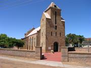
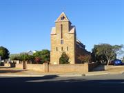
St George’s Church of England
Carnarvon
Gascoyne
Constructed from 1907
| Type | Status | Date | Documents |
|---|---|---|---|
| Heritage List | Adopted | 26 Feb 1988 | |
| Heritage List | Adopted | 23 Jun 2015 | |
| State Register | Registered | 15 Oct 1999 | HCWebsite.Listing+ListingDocument, HCWebsite.Listing+ListingDocument |
| Type | Status | Date | Documents |
|---|---|---|---|
| (no listings) |
| Type | Status | Date | Grading/Management | |
|---|---|---|---|---|
| Category | ||||
| Classified by the National Trust | Classified | 01 Jun 1989 | ||
| Register of the National Estate | Indicative Place | |||
| Register of the National Estate | Nominated | 17 Mar 1992 | ||
| Municipal Inventory | Adopted | 23 Jun 2015 | Category 1 | |
| Name | Type | Year From | Year To |
|---|---|---|---|
| Eales & Cohen | Architect | - | - |
| Joseph Herbert Eales | Architect | - | - |
| Library Id | Title | Medium | Year Of Publication |
|---|---|---|---|
| 519 | Carnarvon. | Book | 1980 |
| 9183 | St George's Anglican Church, Carnarvon | Heritage Study {Cons'n Plan} | 2008 |
Individual Building or Group
| Epoch | General | Specific |
|---|---|---|
| Original Use | RELIGIOUS | Church, Cathedral or Chapel |
| Present Use | RELIGIOUS | Church, Cathedral or Chapel |
| Style |
|---|
| Federation Gothic |
| Type | General | Specific |
|---|---|---|
| Wall | BRICK | Common Brick |
| Roof | METAL | Corrugated Iron |
| General | Specific |
|---|---|
| SOCIAL & CIVIC ACTIVITIES | Religion |
This information is provided voluntarily as a public service. The information provided is made available in good faith and is derived from sources believed to be reliable and accurate. However, the information is provided solely on the basis that readers will be responsible for making their own assessment of the matters discussed herein and are advised to verify all relevant representations, statements and information.
The Church has a significance for its architectural and technical accomplishment in its well preserved amenity of style and materials. It has historical significance for its association with its designer the Perth architect J. Herbert Eales who designed mane small country town buildings in and arts and crafts manner, and for its local esteem. The picturesque massing of the church has environmental importance for its contribution to the townscape of Francis st.
The building consists of an aisle-less hall-like nave with a timber lines and painted wagonette ceiling. It has a sanctuary with a separate roof and raised floor, a vestry to one side of the sanctuary and an open, half-timbered entrance porch on the main axis. The nave has unusual truncated corners that are reflected in the main roof form. External walls are red-ochred and tuckpointed brickwork with stucco dressings. The bricks are aid to be of local manufacture. Roofing is unpainted corrugated iron that has acquired a patina of Pindan dust characteristic of Carnarvon and other north-west towns. The internal walls are rendered and painted and have a painted timber lined dado. The floor is polished timber. The altar screen communion rail and furniture of carved and polished jarrah are 1940’s origin but are in keeping with the style of the church. Nave windows have very simple leadlights that have suffered recent damage. The three smaller lancets in the sanctuary gable are fine stained glass and also damaged. Apart from the damaged windows, some rising and falling damp probably aggravated by gutter and downpipe problems, the building appears to be in goof, and near-original condition. A fleche bell tower once existed in the slope of the main hip roof over the front door but has disappeared. The church appears to follow the street alignment rather than the orthodox east-west-orientation.
Assessment 1989
This information is provided voluntarily as a public service. The information provided is made available in good faith and is derived from sources believed to be reliable and accurate. However, the information is provided solely on the basis that readers will be responsible for making their own assessment of the matters discussed herein and are advised to verify all relevant representations, statements and information.

Constructed from 1907
Aesthetic Value – St George’s Anglican Church has considerable aesthetic value. The building displays attractive proportions in the roof form, and the truncated corners of the building create an unusual plan-form. Aesthetic Value – St George’s Anglican Church has a high degree of artistic and technical sophistication, both internally and externally, and exhibits a well resolved combination of architectural, symbolic and artistic motifs. Aesthetic Value – St George’s Anglican Church is a distinctive part of the streetscape and makes a positive contribution to the character of the town. Historic Value – St George’s Anglican Church is evidence of the religious and social activities of the Anglican Church in Carnarvon and the Gascoyne district. Historic Value – The growth and development of Carnarvon at the end of the gold boom period is reflected in the construction of St George’s Anglican Church in 1907. Historic Value – St George’s Anglican Church has a very close association with architect J. Herbert Eales, as designer of the Church. Historic Value – The Memorial altar commemorates those from the district who served in the armed forces during World War Two. Historic Value – St George’s Anglican Church has been associated with the Iles family of Carnarvon since its construction. G. Iles was a member of the church building committee and one its first wardens, and the memorial altar rails were presented by the Iles family in memory of Alan Noel Iles, who died in 1944, as a POW in Burma. Historic Value - St George’s Anglican Church has a lengthy association with the Sharp family. Rev William Sharp was the longest serving rector of Carnarvon parish (1896-1922) and the moving force behind the construction of the place. His son Herbert was a lay reader in the 1940s. Historic Value - St George’s Anglican Church is an example of the work of Joseph Herbert Eales, who was responsible for designing a number of buildings constructed in both metropolitan and rural Western Australia. The baptismal font, presented to the Church in 1917, is the work of well-known sculptor, Pietro Porcelli. Social Value - St George’s Anglican Church fulfils an important role in the religious activities of the Carnarvon community and specifically to members of the Anglican Church Social Value - St George’s Anglican Church is valued as a demonstrative piece of local architecture and contributes to the Carnarvon community’s sense of place. Representativeness - St George’s Anglican Church demonstrates the characteristics of the Church class of Christian places of congregational worship in Australia and is representative of the Federation Gothic (c.1890 – c.1915) style of architecture.
The building has distinctive pointed arch stained windows and heavy stucco bands. The bricks are red-ochred and tuck pointed. The building consists of a single aisle less hall. Designed by J. Herbert Easles.
St George’s Anglican Church was constructed of local red brick at a cost of £1400 donated by local pastoralists. The church was designed by architect J. H. Eales directly behind the original church built in 1894. The bricks used in the construction were locally made from pindan clay by the contractor, Sidney Stansmore. The foundation stone at St George’s Anglican Church was laid on the 7th of July, 1907. This stone was laid by the wife of Carnarvon’s first magistrate C.D. Foss. The church has one stained glass window and a three light window on the east side above the sanctuary. The remaining windows were of plain coloured glass. The church displayed fine detailing with louvered roof vents, a bellcote situated on the main roof above the porch entry, and a timber cross on the apex of the entry porch roof. The first service at St George’s Anglican Church was held on Sunday 13 October 1907. For the first 26 years, Reverend W. Sharp officiated as the rector within the church. On the 20th October 1907, the church was consecrated by Bishop Goldsmith of Bunbury. In 1910, Bishop Trower was enthroned as the first Bishop of the Northwest. In the 1960 cyclone, the church had a belfry which was blown down and has never been replaced.
High/High
Good
| Reserve | Lot/Location | Plan/Diagram | Vol/Folio |
|---|---|---|---|
| 600 | 302301 | ||
| 601 | 302301 |
| Owner | Category |
|---|---|
| Anglican Church | Church Property |
This information is provided voluntarily as a public service. The information provided is made available in good faith and is derived from sources believed to be reliable and accurate. However, the information is provided solely on the basis that readers will be responsible for making their own assessment of the matters discussed herein and are advised to verify all relevant representations, statements and information.
21 Johnston Carnarvon
Cnr Rushton & Johnston Sts; Lot 337 on Plan 222239
Church of St Mary Star of the Sea Group
Church of St Mary’s
Carnarvon
Gascoyne
Constructed from 1910
| Type | Status | Date | Documents |
|---|---|---|---|
| Heritage List | Adopted | 26 Feb 1988 | |
| Heritage List | Adopted | 23 Jun 2015 | |
| State Register | Registered | 17 Feb 2006 | HCWebsite.Listing+ListingDocument, HCWebsite.Listing+ListingDocument |
| Type | Status | Date | Documents |
|---|---|---|---|
| (no listings) |
| Type | Status | Date | Grading/Management | |
|---|---|---|---|---|
| Category | ||||
| Classified by the National Trust | Classified | 27 May 1974 | ||
| Register of the National Estate | Indicative Place | |||
| Municipal Inventory | Adopted | 23 Jun 2015 | Category 1 | |
Generally in fair to good condition. The Presbytery (fmr) shows evidence of damage from rising damp and some vertical crackin on the external walls.
| Name | Type | Year From | Year To |
|---|---|---|---|
| Monsignor John Cyril Hawes, | Architect | - | - |
| Summerhayes & Associates (convent) | Architect | 1966 | - |
| Library Id | Title | Medium | Year Of Publication |
|---|---|---|---|
| 5385 | Conservation plan for St Mary's Star of the Sea Church, Carnarvon Western Australia. | Heritage Study {Cons'n Plan} | 1997 |
| 519 | Carnarvon. | Book | 1980 |
| 5671 | St Mary's Star of the Sea Church Carnarvon : 2002 conservation works to roof (final report) | Conservation works report | 2002 |
| 9343 | Assessment and report on Church of St Mary Star of the Sea Group, Carnarvon. | Heritage Study {Other} | 2009 |
| 7211 | Images CD No. 36 : assessment images : Church of St Mary Star of the Sea Group, Carnarvon; Poinciana House, Marble Bar; Corunna Downs Station & Wartime Airbase; Gascoyne Research Station, Carnarvon. | C D Rom | 2004 |
Individual Building or Group
| Epoch | General | Specific |
|---|---|---|
| Present Use | RELIGIOUS | Church, Cathedral or Chapel |
| Present Use | RELIGIOUS | Church Hall |
| Original Use | RELIGIOUS | Church, Cathedral or Chapel |
| Present Use | RELIGIOUS | Monastery or Convent |
| Present Use | RELIGIOUS | Housing or Quarters |
| Present Use | EDUCATIONAL | Combined School |
| Style |
|---|
| Inter-War Free Classical |
| Victorian Georgian |
| Inter-War Romanesque |
| Type | General | Specific |
|---|---|---|
| Wall | BRICK | Common Brick |
| Wall | STONE | Local Stone |
| Roof | METAL | Zincalume |
| Wall | CONCRETE | Concrete Block |
| Roof | METAL | Corrugated Iron |
| General | Specific |
|---|---|
| OCCUPATIONS | Domestic activities |
| SOCIAL & CIVIC ACTIVITIES | Religion |
| SOCIAL & CIVIC ACTIVITIES | Education & science |
This information is provided voluntarily as a public service. The information provided is made available in good faith and is derived from sources believed to be reliable and accurate. However, the information is provided solely on the basis that readers will be responsible for making their own assessment of the matters discussed herein and are advised to verify all relevant representations, statements and information.
Constructed from 1935
Aesthetic Value – Church of St Mary, Star of the Sea displays a high degree of artistic and technical sophistication, both internally and externally, and exhibits a well resolved combination of architectural, symbolic and artistic motifs. Aesthetic Value – Church of St Mary, Star of the Sea is an excellent example of the ecclesiastical architecture of John Cyril Hawes, and is relatively rare as a building, designed by Hawes, constructed of concrete blocks. Aesthetic Value – Church of St Mary, Star of the Sea is a landmark in Carnarvon as a substantial church building sited in a prominent location at the corner of Johnston, Francis and Rushton Streets. Aesthetic Value – Church of St Mary, Star of the Sea, together with the Presbytery, and the Convent School, forms a precinct of early twentieth century Catholic buildings in Carnarvon. Historic Value – Church of St Mary, Star of the Sea was the third Catholic Church to be constructed for the expanding Catholic community of Carnarvon, and is indicative of the growth of the area throughout the early part of the twentieth century. Historic Value – Church of St Mary, Star of the Sea demonstrates the use of locally manufactured concrete blocks for construction during the 1930s, a time of material shortages and economic depression. Historic Value – Church of St Mary, Star of the Sea was designed by acclaimed architect and priest, Monsignor John Cyril Hawes, whose life and works are prominent within the history of the Mid-west region of Western Australia Historic Value – Father John G. Mackay, later Archdeacon Mackay, was involved in overseeing and implementing plans for Church of St Mary, Star of the Sea in his role as the Carnarvon parish priest at the time that the church was constructed, and served as a priest in Carnarvon for over thirty years, from 1930 to the mid-1960s. Research Value – The building is a notable example of the innovative use of building materials and techniques to suit local conditions. Social Value – Church of St Mary, Star of the Sea is valued by the Catholic community of Carnarvon and surrounding districts as a focus of religious activity and the location of many cultural events associated with the life of this community. Social Value – Church of St Mary, Star of the Sea contributes to the Carnarvon community’s sense of place as a prominent building in its streetscape, and as a fine example of the work of John Cyril Hawes. Rarity – Church of St Mary, Star of the Sea is an unusual example of a church constructed of concrete block masonry walls and corrugated colorbond (originally fibre cement) roof sheeting. Representativeness - Church of St Mary, Star of the Sea is representative of Hawes’ distinctive and somewhat eclectic style of church architectural design.
Hawes finished the working drawings for Carnarvon’s Church of St Mary Star of the Sea in 1934, having completed the sketch plans and two form study models in 1933. The Hawes designed church at Carnarvon was built to replace a simple timber-framed structure measuring 40 feet by 20 feet (12.19 metres by 6.10 metres) that had been built in 1901. Hawes’ Carnarvon church design led to some conflict between himself and the parish priest of Carnarvon, Fr John Mackay. Hawes’ already unsettled temperament conflicted with the forthright wishes of his client in this case. Fr Mackay had been disappointed in the delay that Hawes had requested for the design because of his other commitments at Morawa, and then the restrictions that Hawes placed on any alterations to the design of the building. Bishop O’Collins managed to intervene in the conflict, and the Carnarvon church was eventually commenced. The successful tenderer was E. Bello of Maylands with a tender price of 2,087 pounds. The existing church was to be demolished for general sale. The Church of St Mary Star of the Sea was blessed and opened on Sunday 10 November 1935. The appearance of the Carnarvon church differs from the majority of Hawes’ churches in Western Australia, due to the roof and wall materials employed in construction. The cross on the peak of the Carnarvon church is the work of the renowned metal craftsman Wilfred Priestner whom Hawes employed for many of his jobs from the late 1920s.
High/High
Good
| Reserve | Lot/Location | Plan/Diagram | Vol/Folio |
|---|---|---|---|
| 337 | 222239 |
| Owner | Category |
|---|---|
| Roman Catholic Bishop of Geraldton | Church Property |
This information is provided voluntarily as a public service. The information provided is made available in good faith and is derived from sources believed to be reliable and accurate. However, the information is provided solely on the basis that readers will be responsible for making their own assessment of the matters discussed herein and are advised to verify all relevant representations, statements and information.
The Church has architectural significance for its unusual style and appropriately detailed local materials. It has historical significance for its association with its designer, Monsignor Hawes, well known as the designer of the cathedral in Geraldton and other country town churches. With the presbytery and grounds, the place has environmental significance for its contribution to the townscape of Francis St and the Tower is a landmark visible in many vistas around the town.
A concrete block and asbestos tile Church of unusual form, built in 1835 to the design of Monsignor J Hawes. The Church forms a group with its Presbytery on the triangular block that extends back to include the Catholic school behind. The church is aligned with Johnson St, slightly off orthodox orientation, while the Presbytery faces Rushton Street, thus leaving garden space between the two buildings on the north. The presbytery is of an earlier date that the Church, a typical northwest brick and iron two roomed cottage with latticed front verandah to Rushton St. There are various additions to the rear. The cottage wall facing the Church has been rendered to imitate the blockwork of the Church. The Church consists of a tower over an entrance porch, a Nave and a Sacristy and side chapel in the transepts. The symmetrical balance is altered internally by having only one aisle to the south of the nave. On the north side there is a confessional and a porch that gives access to the garden. The tower is unusual in extending almost the full width of the Nave to enclose a gallery opening into the back of the Nave over the porch. The tower narrows beyond the separate gallery roof to become a bell-tower, a strong visual element in Francis St and Carnarvon generally. The roof is covered with Canadian pattern asbestos tiles which have the pindan patina characteristic of Carnarvon and other north west towns. The roof to the Sanctuary is higher than that of the Nave and has been recently ceiled with plasterboard. In the Nave, the asbestos tiles are exposed over hammer beam-like roof trusses which are tied across by steel rods. External walls are constructed of locally made pindan concrete lock with specially shaped blocks to make cornices, corbels and cappings, all of which are in excellent condition and a find example of local building tradition. The colour and texture of these blocks is particularly subtle and well suited to the architectural form and the town scape setting of the building. Inside the walls are rendered and painted including the robust aisle columns so characteristic of Hawe’s work. Gothic windows to the Nave, Sanctuary and gallery have some fine stained and painted glass. Round windows high up in the Sanctuary create a dramatic lighting effect over the altar.
Assessment 1989 Construction: 1934 - 35 Designer: Monsignor J Hawes
This information is provided voluntarily as a public service. The information provided is made available in good faith and is derived from sources believed to be reliable and accurate. However, the information is provided solely on the basis that readers will be responsible for making their own assessment of the matters discussed herein and are advised to verify all relevant representations, statements and information.

North West Coastal Hwy over Gascoyne River Carnarvon
13 km ENE of Carnarvon; Lot 500 on Plan 070483; Road No. 9840 Western Australia Bridge No. 838
10 Mile Bridge
Gascoyne River Bridge
MRWA 838 North West Coastal Highway
Carnarvon
Gascoyne
Constructed from 1931
| Type | Status | Date | Documents |
|---|---|---|---|
| Heritage List | Adopted | 23 Jun 2015 | |
| State Register | Registered | 15 Aug 2003 | HCWebsite.Listing+ListingDocument, HCWebsite.Listing+ListingDocument |
| Type | Status | Date | Documents |
|---|---|---|---|
| (no listings) |
| Type | Status | Date | Grading/Management | |
|---|---|---|---|---|
| Category | ||||
| Register of the National Estate | Permanent | 26 Oct 1999 | ||
| Municipal Inventory | Adopted | 23 Jun 2015 | Category 5 | |
Gascoyne River Bridge (fmr) is a remnant span retained from a 220.8 metre single lane traffic bridge of reinforced concrete and steel construction. In 2002 the original bridge was demolished, with the retention of the span on the northern side.
The bridge was the first concrete and steel construction bridge built in the north west of Western Australia, it was also one of the first bridges in the State designed to withstand intense river flooding and provide a trafficable all-weather crossing.
| Name | Type | Year From | Year To |
|---|---|---|---|
| Ernie WC Godfrey | Architect | - | - |
| Library Id | Title | Medium | Year Of Publication |
|---|---|---|---|
| 519 | Carnarvon. | Book | 1980 |
| 5992 | Gascoyne River bridge, Carnarvon : archival record. | Report | 2002 |
| 6561 | Gascoyne River bridge : interpretation plan. | Heritage Study {Other} | 2002 |
Historic site
| Epoch | General | Specific |
|---|---|---|
| Original Use | Transport\Communications | Road: Bridge |
| Present Use | Transport\Communications | Road: Bridge |
| Type | General | Specific |
|---|---|---|
| Other | CONCRETE | Reinforced Concrete |
| Other | METAL | Steel |
| General | Specific |
|---|---|
| DEMOGRAPHIC SETTLEMENT & MOBILITY | Natural disasters |
| TRANSPORT & COMMUNICATIONS | Road transport |
| DEMOGRAPHIC SETTLEMENT & MOBILITY | Technology & technological change |
This information is provided voluntarily as a public service. The information provided is made available in good faith and is derived from sources believed to be reliable and accurate. However, the information is provided solely on the basis that readers will be responsible for making their own assessment of the matters discussed herein and are advised to verify all relevant representations, statements and information.

Constructed from 1931
Aesthetic Value – Gascoyne River Bridge (fmr) has aesthetic value as a remnant span of a well-constructed structure that overcame the restrictions imposed by its isolation and extreme functional requirements with considerable elegance. Aesthetic Value – Gascoyne River Bridge (fmr) was a demonstration of innovative design as the first concrete and steel construction bridge in the northwest of Western Australia. The achievement was greater because of its isolation and extreme functional requirements. Historic Value – Gascoyne River Bridge (fmr) was an important part in the establishment of the network of all-weather roads that was needed to develop the north of Western Australia, its construction was crucial in the evolution of this part of the State. Historic Value – The construction of Gascoyne River Bridge (fmr) represented a shift in the design of bridges in the state. It was also a product of the period between 1926-1931 in which the State Government, through the Main Roads Board, began to organise the construction of roads and bridges within the State as a network taking over from individual boards. Historic Value – Gascoyne River Bridge (fmr) is associated with engineer Ernie Godfrey who brought an innovative approach to the design and construction of bridges in Western Australia. Gascoyne River Bridge (fmr) is also associated with Charles Bunning who organised the new materials for the project and who went on to lead one of largest building supplies companies in Western Australia. Historic Value – The construction of Gascoyne River Bridge (fmr) was the successful achievement of a new technical innovation in the use of steel and concrete in the design and construction of bridges, particularly in the remote north-west region of Western Australia. Research Value – Gascoyne River Bridge (fmr) is significant in demonstrating the evolution of the technology required for the construction of permanent bridge structures over rivers subject to intense flooding. It demonstrates both the determination of the community in overcoming natural barriers to develop the Carnarvon area and also the larger Northwest Region of the State, and the high degree of technical achievement involved in assessing the natural forces and applying engineering structural design analysis to design and construct economical structures utilising concrete and steel materials. Social Value – Gascoyne River Bridge (fmr) is valued by the community in Carnarvon and the wider community of the Gascoyne region for its associations with floods and the means of overcoming them. The regular gatherings at Gascoyne River Bridge (fmr) during times of flood have united the community at these difficult times. Social Value – Gascoyne River Bridge (fmr) contributes to the community’s sense of place as it has been a crucial link for the town of Carnarvon to the rural community as well its role in linking the north west coast to the south of the State. Rarity – Gascoyne River Bridge (fmr) was the first bridge of concrete and steel construction built in the Northwest of Western Australia designed to withstand intense river flooding and provide a trafficable all-weather crossing. The three earlier concrete and steel construction bridges built in Western Australia were by WAGR over the railway at Barrack, William and Thomas Streets Perth. Representativeness – AS the first of the three bridges that E.W.C Godfrey designed for construction in the north-west, Gascoyne River Bridge (fmr) is representative of the innovative use of reinforced concrete and steel structures to span the flood prone northwest rivers. The Murchison River Bridge and the Ashburton River Bridge are the other two bridges.
Single land motor vehicle bridge. The bridge was one of the first to be built on the north west coast; previously the river was impassable after heavy rain.
The bridge was built to provide secure vehicular crossing over the Gascoyne River, which is subject to severe flooding. Prior to construction, crossing the Gascoyne River was achieved only during the dry season. A riverbed ford crossing consisting of wire mesh, tied and staked to the sandy river enabled safe crossing at this time. Ernie Godfrey was appointed the first engineer in charge of the Bridge Section with construction commencing in 1930. Henry Martin and Company for the Western Australian Main Roads Board successfully tendered for the bridge in partnership with Charles Bunning. The bridge represented a shift in design and techniques of bridge construction in Western Australia. The bridge was opened on 19 April 1931. In September 2002, the original bridge was demolished with retention of the span of the northern side.
Low/Medium
Fair
| Reserve | Lot/Location | Plan/Diagram | Vol/Folio |
|---|---|---|---|
| 500 | 070483 |
| Owner | Category |
|---|---|
| Main Roads Western Australia | State Gov't |
This information is provided voluntarily as a public service. The information provided is made available in good faith and is derived from sources believed to be reliable and accurate. However, the information is provided solely on the basis that readers will be responsible for making their own assessment of the matters discussed herein and are advised to verify all relevant representations, statements and information.
off Olivia Terrace Carnarvon
Lot 1203 on Plan 240082. Reserve 6049.
Babbage Island Causeway Bridge
Town Bridge
Carnarvon
Gascoyne
| Type | Status | Date | Documents |
|---|---|---|---|
| Heritage List | YES | ||
| Heritage List | Adopted | 23 Jun 2015 |
| Type | Status | Date | Documents |
|---|---|---|---|
| (no listings) |
| Type | Status | Date | Grading/Management | |
|---|---|---|---|---|
| Category | ||||
| Classified by the National Trust | Classified | 01 Jun 1989 | ||
| Register of the National Estate | YES | |||
| Municipal Inventory | Adopted | 25 Jun 2015 | Category 1 | |
04566 One Mile Jetty and Tramway
Other Built Type
| Epoch | General | Specific |
|---|---|---|
| Original Use | Transport\Communications | Rail: Other |
| Type | General | Specific |
|---|---|---|
| Other | TIMBER | Other Timber |
| General | Specific |
|---|---|
| TRANSPORT & COMMUNICATIONS | Rail & light rail transport |
| OCCUPATIONS | Grazing, pastoralism & dairying |
This information is provided voluntarily as a public service. The information provided is made available in good faith and is derived from sources believed to be reliable and accurate. However, the information is provided solely on the basis that readers will be responsible for making their own assessment of the matters discussed herein and are advised to verify all relevant representations, statements and information.
04566 One Mile Jetty and Tramway
Aesthetic Value – Importance to a community for aesthetic characteristics through either design or setting. Aesthetic Value – Importance for its contribution to the aesthetic value of the setting demonstrated by a landmark quality of having impact on important vistas. Historical Value – Importance for the density of diversity of cultural features illustrating the human occupation and evolution of the locality. Social Value – Importance as a place highly valued by a community for reasons of social, cultural and education associations. Social Value – Importance in contributing to a community’s sense of space.
The bridge was originally built to connect the town to the jetty. It allowed wool and sandalwood to be transported by train between stores in the town and the jetty. The bridge was built with Aboriginal labour.
The Tramway Bridge is of exceptional significance to the history of Carnarvon. It formed an integral part of the working nature of the town for 85 years (1899‐1984) from its association and connectivity to the One Mile Jetty. It was initially the only major method of import and export of goods to the area – although that role was gradually usurped as the port activities declined with the advent of road transport. The One Mile Jetty’s connection to the town through the tramway in part dictated the areas of commercial development in the town for many years, and the Carnarvon town plan reflects this influence. The Tramway Bridge and Tramway formation add interest to and enliven both the ‘Fascine’ and Babbage and Whitlock Islands’ landscapes. The regular appearance of the weathered piles and timber structure of ‘Town Bridge’ forms a strong linear image and draws the eye as one approaches from either side of Olivia Terrace.
Medium
Poor
| Reserve | Lot/Location | Plan/Diagram | Vol/Folio |
|---|---|---|---|
| 6049 | 1203 | 240082 |
This information is provided voluntarily as a public service. The information provided is made available in good faith and is derived from sources believed to be reliable and accurate. However, the information is provided solely on the basis that readers will be responsible for making their own assessment of the matters discussed herein and are advised to verify all relevant representations, statements and information.
AESTHETIC VALUE: The bridges and tramway formation add interest to and enliven the 'Fascine' and Babbage & Whitlock Island's landscape. The regular appearance of the weathered piles and timber structure draws the eye as one approaches the 'Town Bridge' from either side on Olivia Terrace, and forms a strong linear image. The 'One Mile Jetty' has a similar aesthetic value. HISTORIC VALUE: The Carnarvon Tramway is of exceptional significance to the history of Carnarvon. It formed an integral part of the working nature of the town for almost one hundred years. It was initially the only major method of import and export of goods to the area - although that role was gradually usurped as the port activities declined with the advent of road transport. In part it dictated the areas of commercial development in the town for many years, and the Carnarvon town plan reflects this influence. SCIENTIFIC VALUE: The 'One Mile Jetty' has scientific value in relation to the study of marine life. Social Value. The Carnarvon Tramway is of extremely high social value for its strong commercial association with Carnarvon and the surrounding regional communities developed over many years; and also its recreational value through fishing, access to beaches, even as a port of departure for holidays in earlier times. The Carnarvon Tramway also contributes to the Carnarvon community's sense of place through its' visual landmark qualities. DEGREE OF SIGNIFICANCE, RARITY: The Carnarvon Tramway is now the most intact example of the former Public Works Department tramways serving coastal Western Australia. It was also the longest of its type. The Tramway is unique in still having restorable original fabric right through from the jetty to the receival points at the town. REPRESENTATIVENESS: The Carnarvon Tramway is of exceptional significance in this criterion. An original working locomotive and tramway formation is in working order. The opportunity exists to provide an interpretative experience for the complete circular process that formed the Tramway Precinct. STATEMENT OF CULTURAL SIGNIFICANCE The Carnarvon Tramway has exceptional cultural heritage significance for the following reasons: * visual landmark qualities valued by the people of Carnarvon and the Gascoyne Region of WA * demonstrates a complete circular process developed to cope with and overcome extreme pioneering transport hardships * is an integral part of the developmental history of Carnarvon and the Gascoyne Region * has strong commercial association and familiarity with the people of Carnarvon and the Gascoyne Region * contains major surviving evidence of turn of the century timber bridge (and jetty) design and construction techniques * is a valued recreational asset to the community * is a working and demonstrative example of a process that is in danger of being lost from the State off Western Australia,
The 1060’ timber bridge built circa 1899 connects the town of Carnarvon with the jetty. Whilst no longer in use it is an important part of the Olivia Tce and Fascine landscape. It is built with timber post , beam and plank and has deteriorated in condition to the point where not even pedestrian can use it. Several piles were renewed in 1914 and over the following few years, Piers 50 to 64 were strengthened in 1931 and the west end was extended (approx. 150m) east end (~45m) in 1943. Considerable repairs were carried out in 1981 after the bridge was damaged by a cyclone. A 5 metre section was cut out in June 1995 to allow a dredge to be moved. Bridles built in 1909 , as part of the conversion to 3’6” gauge, Comprised – eight bridges which were made of 2 x 15’spans and one of 22 x 15’ spans – designed to span three major drains. (PWD plan 7093) The remains of the two bridges bypassed in 1934 can be seen. Two other bridges were filled in – in May1995. Years of neglect have lead to the deterioration of these remaining bridges. The 1925 water tank at the jetty end is in fair condition – the tank having deteriorated but the timber stand is still essentially sound. Track relaid by the Carnarvon Light Railway Association comprises sleepers ex-North West Mining Railways and rail line from telegraph pole along the Geraldton to Mullewa railway.
Assessment 1995 Architect/designer: Public Works Dept Builder: Atkins & Law Constructed: 1896-97, 1909 Alterations/Additions: 1909, 1934 The history of tramways in Carnarvon is tied with the role of shipping and jetties. Tramways have been part of Carnarvon life since at least 1892, when the PWD report shows expenditure for tramway repairs. A small service operated with a new 2ft gauge tramway 2 miles and 5 chains long being constructed by Atkins & law being completed by the end of 1900. The contract for this construction included the 1060 foot bridge across the Gascoyne. This followed the completion of the Long Jetty (4290ft) in 1899. However the operation of the tramway experienced many difficulties due to flooding, particularly across the low lying parts of Babbage Island. These problems, together with the inadequacy of the lightweight tramway to cope with the load shipped through the busy port, led to the conversion of the tramway to 3’6” gauge using 35lb rail in 1908-09. The new tramway was generally built along the old formation, which was built up and an additional 9 bridges were constructed. A 2’ gauge loopline from a platform near the root of the jetty was laid to the oil store and lighthouse quarters. With the new bridges the floodwater problems were much decreased. The heavier track also enabled the provision of a small steam locomotive which ensured more efficient handling of cargo. Two larger passenger cars were also provide which no doubt made the journey from jetty to town more pleasant. Until the 1930’s the port, and hence the tramway, was the transport for the local produce of fruit, wool and livestock. Supplies for the region, as well as Blood & Bone from Wyndham were imported in this way. By the 1960’s only bulk fuel traffic remained and so in 1965 the tramway closed as State Ships no longer called at the port. The rail was then sold to the Carnarvon Race Club.
CONDITION. The Carnarvon Tramway is in reasonable condition. The original fabric has deteriorated over time - particularly since the abandonment of regular maintenance procedures, and some portions (several culvert bridges) have been removed. INTEGRITY. The Carnarvon Tramway has a high degree of integrity. The Place has only ever been used for the original purpose for which it was designed, and thus has had very little in the way of intrusive changes. It has great potential for complete restoration. AUTHENTICITY. The Carnarvon Tramway has a high level of authenticity. All the bridges and the majority of the rolling stock are original Carnarvon Tramway facilities. However the new rail currently being laid (on the original formation) is generally being procured from other sources. Almost all the other fabric exists in its original locations.
This information is provided voluntarily as a public service. The information provided is made available in good faith and is derived from sources believed to be reliable and accurate. However, the information is provided solely on the basis that readers will be responsible for making their own assessment of the matters discussed herein and are advised to verify all relevant representations, statements and information.

16 Robinson St Carnarvon
Lot 604 on Plan 302301
Union Bank of Australia Ltd Building
Carnarvon
Gascoyne
Constructed from 1905 to 1989
| Type | Status | Date | Documents |
|---|---|---|---|
| Heritage List | Adopted | 23 Jun 2015 | |
| Heritage List | Adopted | 08 Feb 1991 | |
| State Register | Registered | 24 Mar 2000 | HCWebsite.Listing+ListingDocument, HCWebsite.Listing+ListingDocument |
| Type | Status | Date | Documents |
|---|---|---|---|
| (no listings) |
| Type | Status | Date | Grading/Management | |
|---|---|---|---|---|
| Category | ||||
| Municipal Inventory | Adopted | 23 Jun 2015 | Category 1 | |
| Statewide Bank Survey | Completed | 01 Nov 1997 | ||
| Register of the National Estate | Indicative Place | |||
| Classified by the National Trust | Classified | 01 Jun 1989 | ||
| Name | Type | Year From | Year To |
|---|---|---|---|
| JJ Talbot Hobbs, E H Dean-Smith, WJ Waldie Forbes | Architect | - | - |
| Library Id | Title | Medium | Year Of Publication |
|---|---|---|---|
| 519 | Carnarvon. | Book | 1980 |
Individual Building or Group
| Epoch | General | Specific |
|---|---|---|
| Present Use | COMMERCIAL | Bank |
| Original Use | COMMERCIAL | Bank |
| Style |
|---|
| Federation Free Classical |
| Type | General | Specific |
|---|---|---|
| Wall | BRICK | Common Brick |
| Roof | METAL | Corrugated Iron |
| General | Specific |
|---|---|
| OCCUPATIONS | Commercial & service industries |
This information is provided voluntarily as a public service. The information provided is made available in good faith and is derived from sources believed to be reliable and accurate. However, the information is provided solely on the basis that readers will be responsible for making their own assessment of the matters discussed herein and are advised to verify all relevant representations, statements and information.
Architecturally interesting as a well preserved example of Western Australia's Edwardian country town banks. Variations on this theme still exist in Kalgoorlie, Wagin and Narrogin. It has some significance for its association with the commercial development of the town. It is also an elegant contribution to the streetscape and a prominent landmark of the town.
An elegant double storey building, brick and stucco originally, now with painted walls and additional single storey wings. Ornate pressed metal ceilings inside are well preserved. Built sometime before the First World War, it is still (1989) in use as a bank and is well maintained.
Assessment 1989 Constructed Circa 1910
This information is provided voluntarily as a public service. The information provided is made available in good faith and is derived from sources believed to be reliable and accurate. However, the information is provided solely on the basis that readers will be responsible for making their own assessment of the matters discussed herein and are advised to verify all relevant representations, statements and information.

Constructed from 1975, Constructed from 1906
Aesthetic Value – ANZ Bank Building is a good example of the Federation Free style applied to a commercial building. The place is characteristic of other buildings in Carnarvon’s commercial precinct. Aesthetic Value – ANZ Bank Building is a distinctive part of the streetscape and makes a positive contribution to the character of the town. Aesthetic Value – ANZ Bank Building in association with other buildings adjacent and along Robinson Street forms the commercial precinct of Carnarvon. Historic Value – ANZ Bank Building is closely associated with the development of banking facilities in the agricultural regions of the state in the early part of this century. The scale of the building and materials used reflect the confidence the Union Bank had for the area in the early years of the twentieth century. Historic Value – Built in 1905, ANZ Bank Building represents the growth and development of Carnarvon at the end of the gold boom period. Historic Value – ANZ Bank Building is closely associated with the ANZ Banking Group, and the financial life of Carnarvon and surrounding pastoral and agricultural districts. The place was purpose built for its predecessor and has housed its banking functions since 1905. Historic Value – ANZ Bank Building was purpose built for the Union Bank. It was also the first bank built in Carnarvon. Historic Value – ANZ Bank Building was designed by architect J. J. Talbot Hobbs, and his partners E. H. Dean Smith & W. J. Waldie Forbes, who were also responsible for the Bank of New South Wales, Carnarvon (1928) (Homeswest Building), as well as many other bank buildings throughout the State. Historic Value – Local bricks, made by Sidney Stansmore, were used in the construction of ANZ Bank Building. Stansmore manufactured bricks used in the construction of several buildings in Carnarvon being the Anglican Church, former Masonic Hall and Lefroy Townhouse. Social Value – ANZ Bank Building holds significant social value to the Carnarvon community as it contributes to the community’s sense of place, having occupied a prominent site on Carnarvon’s main street since 1905. The place has figured prominently in the financial life of the community. Representativeness – ANZ Bank Building is representative of the Federation Free Classical style used in the design of buildings for the Union Bank of Australia from the late 1890s to the 1920s.
A substantial two storey building with a prominent entrance portico embellished with stucco decorative elements. The building previously housed the Union Bank.
ANZ Bank Building is a two storey brick and iron building constructed in 1905, for the Union Bank of Australia Ltd, to a design by architects Hobbs, Smith & Forbes. Various additions and alterations have been made to ANZ Bank Building over the years. The Union Bank of Australia established a presence in Carnarvon on 3 June 1902, after the bank’s Western Australian inspector identified ‘good prospects’ at Carnarvon, considering the area to be particularly attractive because it was believed to be ‘not subject to drought’. The Union Bank did not build their premises immediately, but waited to see how well their banking business would develop in the district. Edward Houghton Angelo was the first manager of the Union Bank in Carnarvon. While the Union Bank was the first trading bank to operate in Carnarvon, banking services were already being conducted by Dalgety and Company. The bricks used in the construction were locally made by the contractor, Sidney Stansmore. The Union Bank of Carnarvon became ANZ Bank Building in October 1951, with the merger of the Union Bank of Australia and the Bank of Australasia to form the Australia and New Zealand Bank. In 1953, Hobbs, Winning and Leighton designed a two storey brick addition to the north-east side of ANZ Bank Building, accessed from the original private side entry. In 1967, architects Duncan, Stephen & Mercer designed an extension of the banking chamber, which entailed a single storey addition on the east side of the building and to the frontage of the 1953 toilet addition. In 1972, another single-storey addition was made on the west side of the building. Internal renovations were carried out in January 1989. In 1998, the outer leaf of brickwork on the upper section of the west wall peeled off and collapsed onto the roof of the single-storey extension below. The wall has been repaired. The ANZ Bank Building continues to provide banking services for the district today.
HIgh/Medium
Good
| Reserve | Lot/Location | Plan/Diagram | Vol/Folio |
|---|---|---|---|
| 604 | 302301 |
| Owner | Category |
|---|---|
| Dudley Maslen | Other Private |
This information is provided voluntarily as a public service. The information provided is made available in good faith and is derived from sources believed to be reliable and accurate. However, the information is provided solely on the basis that readers will be responsible for making their own assessment of the matters discussed herein and are advised to verify all relevant representations, statements and information.

30 Robinson St Carnarvon
Cnr Stuart St; Lot 195 on Plan 222239
Bank of New South Wales (NSW)
Main Roads Office
Carnarvon
Gascoyne
Constructed from 1929 to 1961
| Type | Status | Date | Documents |
|---|---|---|---|
| Heritage List | Adopted | 23 Jun 2015 | |
| State Register | Registered | 07 Jan 2000 | HCWebsite.Listing+ListingDocument, HCWebsite.Listing+ListingDocument |
| Type | Status | Date | Documents |
|---|---|---|---|
| (no listings) |
| Type | Status | Date | Grading/Management | |
|---|---|---|---|---|
| Category | ||||
| Municipal Inventory | Adopted | 23 Jun 2015 | Category 1 | |
| Name | Type | Year From | Year To |
|---|---|---|---|
| J J Talbot Hobbs, E H Dean-Smith & W J Waldie Forbes | Architect | - | - |
| John Talbot Hobbs, Edward H Smith & Walter James Forbes | Architect | - | - |
Individual Building or Group
| Epoch | General | Specific |
|---|---|---|
| Other Use | COMMERCIAL | Office or Administration Bldg |
| Present Use | GOVERNMENTAL | Office or Administration Bldg |
| Original Use | COMMERCIAL | Bank |
| Style |
|---|
| Inter-War Free Classical |
| Type | General | Specific |
|---|---|---|
| Wall | CONCRETE | Concrete Block |
| Roof | METAL | Corrugated Iron |
| General | Specific |
|---|---|
| OCCUPATIONS | Commercial & service industries |
| SOCIAL & CIVIC ACTIVITIES | Community services & utilities |
This information is provided voluntarily as a public service. The information provided is made available in good faith and is derived from sources believed to be reliable and accurate. However, the information is provided solely on the basis that readers will be responsible for making their own assessment of the matters discussed herein and are advised to verify all relevant representations, statements and information.

Constructed from 1929
Aesthetic Value – Homeswest Building, constructed in the Inter-War Free Classical style, has aesthetic value as a commercial building characteristic of the commercial precinct in Carnarvon. Aesthetic Value – Homeswest Building has landmark quality due to its prominent location on the corner of Robinson, Stuart and Francis Streets. The place is also a part of the vista toward the War Memorial and Civic Area on Francis Street. Aesthetic Value – Homeswest Building in association with other buildings adjacent and along Robinson Street form the commercial precinct of Carnarvon. Historic Value – Homeswest Building is closely associated with the development of banking facilities in the agricultural regions of the State in the early part of this century. Previous occupation of the building illustrates the human occupation and evolution of the Carnarvon locality. Historic Value – The construction of Homeswest Building marked the takeover of the Western Australian Bank by a national banking corporation, the Bank of New South Wales, during a period of growth in the 1920s and the building boom which came as a result. Historic Value – Homeswest Building has been associated with the Bank of New South Wales (1928 to 1942), Main Roads (1950 to 1985) and Homeswest (1985 to 1999). Historic Value – Homeswest Building was designed by architect J. J. Talbot Hobbs, and his partners, E. H. Dean Smith & W. J. Waldie Forbes, who were also responsible for the ANZ Bank Building, Carnarvon (1905), as well as other bank buildings throughout the state. Social Value - Homeswest Building is valued by the local community for its associations with the provision of roads and public housing in the district. Social Value – Homeswest Building holds significant social value to the Carnarvon community as it contributes to the community’s sense of place. Social Value –Situated on a prominent corner site in the centre of town, Homeswest building has provided a significant presence since 1928, replacing the shops that had occupied the site for the previous twenty years and contributing to the local community’s sense of place. Representativeness –Homeswest Building is representative of the Inter-War Free Classical Style.
A substantial commercial building with a rendered façade and decorative stucco treatment.
Homeswest Building is a single-storey brick and iron building constructed in Inter War Free Classical style in 1929. The place was designed by architectural firm Hobbs, Smith & Forbes, as banking chambers and residence for the Bank of New South Wales. In 1950, the place was occupied by Main Roads, and was renovated and extended in 1961. Since 1985, the place has been occupied by Homeswest. The Bank of New South Wales engaged architects Hobbs, Smith & Forbes to design their new bank building. Tenders for the construction of the place closed on 16 December 1927, and the lowest quote of 4707 pounds, submitted by B. Blackwell, was accepted the following month. The Bank of New South Wales operated its Carnarvon branch only until 1942, when it closed the bank due to war time rationalisation policies. The branch’s 127 accounts together with 40,000 pounds in deposits were transferred to the Carnarvon Union Bank. In 1950, the Bank’s property was purchased by the State Government Public Works Department, for 7,000 pounds for use as offices. The office space was occupied by Main Roads and the Department of Native Affairs, while the Tropical Agricultural Officer inhabited the residence. In 1955, Main Roads purchased the building from Public Works at a cost of 8,500 pounds, and the entire building was occupied by Main Roads staff. In 1961, the Main Roads office at Carnarvon was extended and renovated by Messrs Scott & Cahill, at a cost of 9,694 pounds. In 1985, Homeswest purchased the building for $130,000 being responsible for the provision of housing and improved housing standards in the State.
High/Medium
Good
| Reserve | Lot/Location | Plan/Diagram | Vol/Folio |
|---|---|---|---|
| 195 | 222239 |
| Owner | Category |
|---|---|
| Department of Housing | State Gov't |
This information is provided voluntarily as a public service. The information provided is made available in good faith and is derived from sources believed to be reliable and accurate. However, the information is provided solely on the basis that readers will be responsible for making their own assessment of the matters discussed herein and are advised to verify all relevant representations, statements and information.

South River Rd cnr Research Rd Carnarvon
note: MI listing is for House 3 only. ; Lot 125 on Plan 202366; R18009
Carnarvon Research Station
Carnarvon
Gascoyne
Constructed from 1940
| Type | Status | Date | Documents |
|---|---|---|---|
| Heritage List | Adopted | 23 Jun 2015 | |
| State Register | Registered | 20 Apr 2007 | HCWebsite.Listing+ListingDocument, HCWebsite.Listing+ListingDocument |
| Type | Status | Date | Documents |
|---|---|---|---|
| (no listings) |
| Type | Status | Date | Grading/Management | |
|---|---|---|---|---|
| Category | ||||
| Fire & Rescue Service Heritage Inventory | Completed | 30 Jun 2000 | ||
| Municipal Inventory | Adopted | 23 Jun 2015 | Category 1 | |
Good
| Library Id | Title | Medium | Year Of Publication |
|---|---|---|---|
| 5471 | Thematic history and preliminary heritage assessment of Agricultural Research Stations. | Report | 2000 |
| 7211 | Images CD No. 36 : assessment images : Church of St Mary Star of the Sea Group, Carnarvon; Poinciana House, Marble Bar; Corunna Downs Station & Wartime Airbase; Gascoyne Research Station, Carnarvon. | C D Rom | 2004 |
Individual Building or Group
| Epoch | General | Specific |
|---|---|---|
| Present Use | SCIENTIFIC | Laboratory or Research Station |
| Original Use | SCIENTIFIC | Laboratory or Research Station |
| Style |
|---|
| Vernacular |
| Type | General | Specific |
|---|---|---|
| Wall | TIMBER | Weatherboard |
| Roof | METAL | Corrugated Iron |
| Wall | ASBESTOS | Fibrous Cement, flat |
| General | Specific |
|---|---|
| SOCIAL & CIVIC ACTIVITIES | Education & science |
| OCCUPATIONS | Rural industry & market gardening |
This information is provided voluntarily as a public service. The information provided is made available in good faith and is derived from sources believed to be reliable and accurate. However, the information is provided solely on the basis that readers will be responsible for making their own assessment of the matters discussed herein and are advised to verify all relevant representations, statements and information.

Constructed from 1940
Aesthetic Value – Gascoyne Research Station forms a spacious rural cultural landscape combining low-key vernacular architecture with an understated tropical setting. Historic Value – Gascoyne Research Station is illustrative of State Government support for land settlement and agricultural advancement, with various schemes developed since the late 1880s to improve farming conditions and encourage people to take up agricultural land. Historic Value – Gascoyne Research Station is significant for its role in the ongoing development of tropical agriculture in the Gascoyne district, which is one of the region’s major industries. Historic Value – Gascoyne Research Station has been associated with the Western Australian Department of Agriculture and its officers since establishment in 1940. Research Value - Gascoyne Research Station has scientific value for its role as a research station specialising in tropical agriculture, which undertook research to facilitate botanical understanding and horticulture development of the Gascoyne region, in particular with regards to irrigation. Social Value – Gascoyne Research Station is valued by the farmers of the Gascoyne district of its association with the establishment of tropical agriculture in the region, and has value for Departmental employees who have worked and lived there since its establishment in 1940. Social Value – Gascoyne Research Station contributes to a sense of place for the local community in its central position with the Gascoyne River settlement. Rarity – Gascoyne Research Station is rare as the only research station in Western Australia to specialise in horticulture for the northwest, and one of only two established in the State for research into tropical agriculture. Representativeness – Gascoyne Research Station is a good representative example of an agricultural research station of the World War Two and immediate post World War Two period with only minimal adaptation for the tropical climate, and demonstrates a way of work and life for employees at the place.
Gascoyne Research Station, comprising an office, eleven employee dwellings, packing shed, tractor shed, workshop, nursery, water tanks, outbuildings and trial plots of various plantings first established in 1940.
Gascoyne Research Station comprises an office, eleven employee dwellings, packing shed, tractor shed, workshop, nursery, water tanks, outbuildings and trial plots of various tropical agricultural plantings established since 1940. After World War One, agriculture was promoted in Carnarvon under the Soldier Settlement Scheme and a subdivision for tropical agriculture was established along the Gascoyne River. In 1922, the Secretary of the North West requested 30 acres of the subdivision be set aside as an experimental plot. By the late 1920s, some banana plantations had been established and there was market gardening of tomatoes and beans by Yugoslav, Italian and Czechoslovakian migrants who were drawn to the area. In 1935 bananas and pineapples, with beans as a cash crop, were giving encouraging results, and a variety of other tropical and subtropical crops such as citrus, grapes, papaya, passionfruit, tomatoes and Lucerne were being produced. Gascoyne Research Station was established in 1940 with the aim to ‘further the development and ultimate settlement of the North-West of Western Australia’. A house (House 2) was constructed at the Station by builder Ken Illingworth and was occupied by Bert Day and his wife in September 1940. Irrigation was provided by sinking a cement well casing 27 feet into the River bed to tap the subsurface waters in the river sands. The work at Gascoyne Research Station predominately involved test trials for irrigation routines, pest and disease control, weed control, fertiliser performance, and the performance of different varieties under varied conditions. The intent of the research was to investigate anything that could potentially enhance production, efficiency and cost control in local plantations. In 1974, Gascoyne Research Station acquired adjoining land (House 10) to expand their operations and various sheds were added to house machinery, workshops and a nursery. In 1983, the office building was extended and the Department of Agriculture began focusing on environment and soil conservation. Gascoyne Research Station continues to operate as a research facility for tropical fruits and vegetables, as well as the centre of Department of Agriculture operations for the district.
High/High
Good
| Reserve | Lot/Location | Plan/Diagram | Vol/Folio |
|---|---|---|---|
| 18009 | 125 | 202366 |
| Owner | Category |
|---|---|
| Department of Agriculture & Food | State Gov't |
This information is provided voluntarily as a public service. The information provided is made available in good faith and is derived from sources believed to be reliable and accurate. However, the information is provided solely on the basis that readers will be responsible for making their own assessment of the matters discussed herein and are advised to verify all relevant representations, statements and information.