Local Government
Cockburn
Region
Metropolitan
Beenyup Rd Reserve Atwell
Between Bartram & Tapper Rd.
Cockburn
Metropolitan
| Type | Status | Date | Documents |
|---|---|---|---|
| (no listings) |
| Type | Status | Date | Documents |
|---|---|---|---|
| (no listings) |
| Type | Status | Date | Grading/Management | |
|---|---|---|---|---|
| Category | ||||
| Municipal Inventory | Adopted | 10 Apr 2014 | Category T | |
Tree
| Epoch | General | Specific |
|---|---|---|
| Present Use | OTHER | Other |
| Original Use | OTHER | Other |
This information is provided voluntarily as a public service. The information provided is made available in good faith and is derived from sources believed to be reliable and accurate. However, the information is provided solely on the basis that readers will be responsible for making their own assessment of the matters discussed herein and are advised to verify all relevant representations, statements and information.
The paperbarks provide an aesthetically pleasing tree lined avenue within a new residential development area. There are no similar features anywhere else in the area.
There are up to 200 paperbark trees (Melaleuca Rhaphiophylla) along the roadside (both sides) of Beenyup Road in Atwell. The trees range from c. 20 to 40 years of age and are generally in good condition. Subdivision approval granted to construct a housing development on either side of Beenyup Road required the developers to leave the remnant paperbarks intact. The paperbarks provide an aesthetically pleasing tree lined avenue within a new residential development area.
Beenyup road was one of the first roads constructed by the Jandakot Districts Road Board before its disbandment in 1871. The road has seen numerous upgrades over the years. One of the distinguishing features of the portion of Beenyup road between Tapper Road and Gibbs Road are the paperbark trees which line the roadside.
Good
| Ref ID No | Ref Name | Ref Source | Ref Date |
|---|---|---|---|
| Register National Estate | |||
| Arboriculturalist’s report. | |||
| National Trust Australia (WA) Documentation | National Trust WA | ||
| HCWA Database No. 17008 | State Heritage Office |
This information is provided voluntarily as a public service. The information provided is made available in good faith and is derived from sources believed to be reliable and accurate. However, the information is provided solely on the basis that readers will be responsible for making their own assessment of the matters discussed herein and are advised to verify all relevant representations, statements and information.
Tapper Rd Atwell
Traffic Island
Cockburn
Metropolitan
| Type | Status | Date | Documents |
|---|---|---|---|
| (no listings) |
| Type | Status | Date | Documents |
|---|---|---|---|
| (no listings) |
| Type | Status | Date | Grading/Management | |
|---|---|---|---|---|
| Category | ||||
| Municipal Inventory | Adopted | 10 Apr 2014 | Category T | |
Tree
| Epoch | General | Specific |
|---|---|---|
| Original Use | OTHER | Other |
| Present Use | OTHER | Other |
This information is provided voluntarily as a public service. The information provided is made available in good faith and is derived from sources believed to be reliable and accurate. However, the information is provided solely on the basis that readers will be responsible for making their own assessment of the matters discussed herein and are advised to verify all relevant representations, statements and information.
Nowhere else in Cockburn has a tree of this size been retained within a road reserve or a traffic island, with the exception of Rockingham Road at Henderson.
Located on a traffic island, this Paperbark tree (Melaleuca Rhaphiophylla) is estimated to be around 80 years old and has a broad trunk which parts about half a metre from ground level to form two smaller trunks.
For many years the area of Atwell was undeveloped bushland and rural dairy farming area. Paperbark trees like this one were once widespread in the area. When the Atwell residential subdivision was constructed, the State Government developer, Landcorp, was approached by residents to conserve the tree. Representations were also made to the City during this time. Consequently, the developer and the City agreed to retain the tree and construct a traffic island around it, forming an aesthetically pleasing garden in the middle of Tapper Road.
Fair
This information is provided voluntarily as a public service. The information provided is made available in good faith and is derived from sources believed to be reliable and accurate. However, the information is provided solely on the basis that readers will be responsible for making their own assessment of the matters discussed herein and are advised to verify all relevant representations, statements and information.
Armadale Rd Banjup
Reserve 38912
Cockburn
Metropolitan
| Type | Status | Date | Documents |
|---|---|---|---|
| Heritage List | Adopted | 14 Jul 2011 |
| Type | Status | Date | Documents |
|---|---|---|---|
| (no listings) |
| Type | Status | Date | Grading/Management | |
|---|---|---|---|---|
| Category | ||||
| Municipal Inventory | Adopted | 10 Apr 2014 | Category B | |
Urban Park
| Epoch | General | Specific |
|---|---|---|
| Original Use | PARK\RESERVE | Park\Reserve |
| Present Use | PARK\RESERVE | Park\Reserve |
| General | Specific |
|---|---|
| OUTSIDE INFLUENCES | World Wars & other wars |
| SOCIAL & CIVIC ACTIVITIES | Community services & utilities |
This information is provided voluntarily as a public service. The information provided is made available in good faith and is derived from sources believed to be reliable and accurate. However, the information is provided solely on the basis that readers will be responsible for making their own assessment of the matters discussed herein and are advised to verify all relevant representations, statements and information.
Banjup Memorial Park is associated with those men from the district who enlisted in World War I, and has social significance for the RSL and the descendents of those men commemorated. Banjup Memorial Park has aesthetic value as a designed small park set within a natural bush area.
This small memorial park stands in a bush setting next to Armadale Road. The fourteen gum trees are surrounded by a white post and rail fence. The oblong shaped park covers approximately 100 sq metres. A bench seat is supplied for visitors to the park.
Banjup Memorial Park was established after World War I. A gum tree was planted for each of the fourteen men from the district who had enlisted. If any of the trees dies, another is planted in its place. A plaque naming the men is displayed at the park and another is held at the Azelia Ley Homestead. The plaque names the men who returned safely as well as those who were wounded or killed. Cockburn RSL maintains Banjup Memorial Park.
INTEGRITY: Only two trees have been replaced, though some appear to need replacement at some point in the future. AUTHENTICITY: High
Good
| Ref ID No | Ref Name | Ref Source | Ref Date |
|---|---|---|---|
| HCWA No. 10162 | State Heritage Office | ||
| National Trust Australia (WA) Documentation | |||
| Register National Estate |
| Owner | Category |
|---|---|
| City of Cockburn | Local Gov't |
This information is provided voluntarily as a public service. The information provided is made available in good faith and is derived from sources believed to be reliable and accurate. However, the information is provided solely on the basis that readers will be responsible for making their own assessment of the matters discussed herein and are advised to verify all relevant representations, statements and information.
Lot 90 Forrest Rd Bibra Lake
Cockburn
Metropolitan
| Type | Status | Date | Documents |
|---|---|---|---|
| (no listings) |
| Type | Status | Date | Documents |
|---|---|---|---|
| (no listings) |
| Type | Status | Date | Grading/Management | |
|---|---|---|---|---|
| Category | ||||
| Municipal Inventory | Adopted | 10 Apr 2014 | Category T | |
Tree
| Epoch | General | Specific |
|---|---|---|
| Original Use | OTHER | Other |
| Present Use | OTHER | Other |
| General | Specific |
|---|---|
| SOCIAL & CIVIC ACTIVITIES | Environmental awareness |
This information is provided voluntarily as a public service. The information provided is made available in good faith and is derived from sources believed to be reliable and accurate. However, the information is provided solely on the basis that readers will be responsible for making their own assessment of the matters discussed herein and are advised to verify all relevant representations, statements and information.
This stand of Woody Pears (Xylomelum occidentale) is an uncommon species in urban areas in the Perth Metropolitan Area.
The stand of Woody Pears (Xylomelum occidentale) is located in a central traffic median on Blueridge Crest, Bibra Lake. Woody Pears are large shrubs or trees, up to 8 m high, occurring in sand in woodlands on the Coastal Plain from Wanneroo southward. The trees have a fibrous bark and the leaves have a prickly edge. The flowers are a leafy panicle of spikes, rarely of one spike, up to 250 x 250 mm. The spikes are up to 120 mm long. The calyx is a creamy white, 10-12 mm long, and softly 191 | P a g e hairy. The fruit is an ovoid shape, tapering above the middle and is thick, woody and hairy. The plant flowers in summer between December-February.
The trees were identified as an unusually good stand of Woody Pears when the City of Cockburn’s first Municipal Inventory was adopted in 1998, which is why they were retained in the road reserve when this area was subdivided for residential development.
| Ref ID No | Ref Name | Ref Source | Ref Date |
|---|---|---|---|
| National Trust Australia (WA) Documentation | National Trust WA | ||
| HCWA Database No. 10201 | State Heritage Office | ||
| Marchant, Wheeler, Rye, Bennett, Lander & macFarlane; "Flora of the perth Region- Part 1". |
This information is provided voluntarily as a public service. The information provided is made available in good faith and is derived from sources believed to be reliable and accurate. However, the information is provided solely on the basis that readers will be responsible for making their own assessment of the matters discussed herein and are advised to verify all relevant representations, statements and information.
7 Homestead Av Bibra Lake
Lot 68
Cockburn
Metropolitan
Constructed from 1890
| Type | Status | Date | Documents |
|---|---|---|---|
| Heritage List | Adopted | 14 Jul 2011 |
| Type | Status | Date | Documents |
|---|---|---|---|
| (no listings) |
| Type | Status | Date | Grading/Management | |
|---|---|---|---|---|
| Category | ||||
| Municipal Inventory | Adopted | 10 Apr 2014 | Category B | |
Very Good.
Individual Building or Group
| Epoch | General | Specific |
|---|---|---|
| Present Use | RESIDENTIAL | Single storey residence |
| Original Use | RESIDENTIAL | Single storey residence |
| Type | General | Specific |
|---|---|---|
| Wall | BRICK | Handmade Brick |
| Roof | METAL | Corrugated Iron |
| General | Specific |
|---|---|
| PEOPLE | Innovators |
This information is provided voluntarily as a public service. The information provided is made available in good faith and is derived from sources believed to be reliable and accurate. However, the information is provided solely on the basis that readers will be responsible for making their own assessment of the matters discussed herein and are advised to verify all relevant representations, statements and information.
Constructed from 1890
Residence: Meller is a significant early property in Cockburn, with high architectural significance as a substantial, and well-resolved residence. Residence: Meller is associated with well-known Cockburn pioneer, Joe Meller.
Originally set in a rural area, this house, made of sundried bricks, is now surrounded by modern suburban houses. There is a verandah, part of which has been enclosed by weatherboard, along three sides. There are three chimneys. The hipped roof is made from corrugated iron.
Land in the area of Lake Walliabup began to be settled from the late 1880s for market gardening, dairying and orchards. The lake was known by the locals as Bibra's Lake. The settlement of the district responded to the buoyant economic times brought about by the gold boom and the rapid increase in population that accompanied it, which greatly increased the demand for fresh food produce. In December 1894, Fremantle hotelkeeper Samuel Barker Shanks paid £50 for the Crown Grant of Cockburn Sound Location 439 of 100 acres. Two months later, on 13 February 1895, Joseph Meller raised a mortgage on the land of £100 with the Bank of Australasia and on 20 February the title to Location 439 was transferred to his name. Meller had arrived in Western Australia with his wife, Eliza, on the Glen Morvan on 20 September 1885. That year, the birth of their first child, May, is recorded. Subsequently, Ernest was born in 1888, Arthur in 1890 and Olive in 1894. From 1886 to 1889 Joseph Meller is listed as a shopkeeper in Fremantle, while also holding land at Bibra Lake from April 1887 on conditional purchase. Conditional purchase required the buyer to complete improvements, such as clearing and fencing and building a dwelling, within a stipulated time frame, usually five years, in order to acquire the title to the land at a reduced price. Meller paid £2-10-0 a year for his lease while fulfilling the conditions for purchase, which in the case of Location 439 included having to reside on the land within six months and to fence one tenth of the boundaries.5 Meller's 100 acres contained good swamp land, which was perfect for market gardening. Many of the swamps and lakes in and around Perth had been used for market gardening, initially by European settlers and later by the Chinese. Why the grant was first acquired by Samuel Shanks is open to speculation. In December 1894, Meller had been working the land for seven and a half years, half as long again as needed for the conditional purchase. He may have been under pressure to finalise the purchase before someone else offered to buy the property from the Government, in which case he would have lost both land and family home, at that time a weatherboard and iron building. He and Shanks apparently came to an arrangement which allowed Meller to obtain a mortgage on the land and thus obtain the funds to purchase the title from him. There was the opportunity of better returns for the market garden with the rapidly increasing population that had flocked to Western Australia because of the gold finds, a matter which would have influenced the bank when it came to providing a mortgage. In 1897, Joseph Meller paid out his mortgage to the Bank of Australasia, raising another for £75 with the Agricultural Bank. In 1899, he sold 10 acres of Location 439 from an L-shaped projection in the south-west corner and appears to have put the funds toward discharging his current mortgage at that time. By 1900, Joseph Meller had 12 acres of market garden and three acres of vineyard. The first house on the property that the family occupied was a weatherboard and iron roofed dwelling. When Joseph established his market garden his eldest child was three years old and three others were born during the period he was still leasing the land. He had no family labour force to assist. Any labour had to be provided by himself and Eliza - when she had time from bearing and raising children - or hired. When it came time to purchase the property a mortgage was needed. There was no money to spare for a new home until much later, most likely in the late 1890s or early 1900s, given the features of the nicely finished building with its jarrah floorboards, sash windows and cast iron fireplaces. The Homestead that Joseph Meller built at that time was constructed with mud bricks made on the property. In 1903, Meller raised a new £150 mortgage with the Agricultural Bank. Perhaps this provided the finance for the Homestead, but by this time, produce prices were falling with the decline in gold production and times were becoming difficult. A caveat was put on the property and was not lifted until November 1905 when Joseph obtained a £400 mortgage from William Dalgety Moore and paid out the Bank mortgage.9 This large mortgage coincided with Joseph's switch to dairy farming, along with a number of other settlers in the district.10 In 1919, Joseph Meller had a dairy herd of 38.11 In that year, he sold another 15 acres of land on the west side of the property, leaving a landholding of 75 acres.12 Eliza Meller died in 1913, age 62, and a decade later, on 1 September 1923, Joseph himself died. Title to the property was transferred to son Ernest. Ernest Meller ran 50 cows on the Bibra Lake property, delivering 80 gallons of milk a day to Fremantle retailers. Maize crops were grown in the swamp for summer feed, and in the winter the herd was grazed on a block in Forrest Road, Jandakot.13 With the advent of the motor vehicle came the ability to cart fresh milk to Perth and Fremantle from a greater distance away, and dairy farming moved further south to better soils. From 1925, dairy farmers began to leave the Bibra Lake district. Ernest Meller is not listed as a dairyman after 1927, although that cannot be taken as definitive as occupations had gradually ceased to be. In 1887 Joe Meller's father selected land east of Bibra Lake. Joe was renowned for his long walks to get food and supplies. He carried very heavy bags of flour and other groceries on his walk home to Bibra Lake. He contributed to church life by blowing the bellows of the organ at Sunday services. The farm land was used for market gardens, dairy cattle and later for horse agistment. Ernie Meller, son of Joe, followed in his father's footsteps by carrying on the dairy herd on their farm. He supported the summer feed for the cows by growing maize on the banks of Bibra Lake.
INTEGRITY: High AUTHENTICITY: Most original exterior fabric is intact
Very Good
| Ref ID No | Ref Name | Ref Source | Ref Date |
|---|---|---|---|
| National Estate Study |
This information is provided voluntarily as a public service. The information provided is made available in good faith and is derived from sources believed to be reliable and accurate. However, the information is provided solely on the basis that readers will be responsible for making their own assessment of the matters discussed herein and are advised to verify all relevant representations, statements and information.
Hope Rd Bibra Lake
Cockburn
Metropolitan
| Type | Status | Date | Documents |
|---|---|---|---|
| (no listings) |
| Type | Status | Date | Documents |
|---|---|---|---|
| (no listings) |
| Type | Status | Date | Grading/Management | |
|---|---|---|---|---|
| Category | ||||
| (no listings) | ||||
Individual Building or Group
| Epoch | General | Specific |
|---|---|---|
| Present Use | RESIDENTIAL | Single storey residence |
| Original Use | RESIDENTIAL | Single storey residence |
This information is provided voluntarily as a public service. The information provided is made available in good faith and is derived from sources believed to be reliable and accurate. However, the information is provided solely on the basis that readers will be responsible for making their own assessment of the matters discussed herein and are advised to verify all relevant representations, statements and information.
Hope Rd cnr North Lake Rd Bibra lake
Cockburn
Metropolitan
Constructed from 1900
| Type | Status | Date | Documents |
|---|---|---|---|
| (no listings) |
| Type | Status | Date | Documents |
|---|---|---|---|
| (no listings) |
| Type | Status | Date | Grading/Management | |
|---|---|---|---|---|
| Category | ||||
| Municipal Inventory | Adopted | 10 Apr 2014 | Category T | |
05317 North Lake & Bibra Lake
Tree
| Epoch | General | Specific |
|---|---|---|
| Present Use | OTHER | Other |
| Original Use | OTHER | Other |
This information is provided voluntarily as a public service. The information provided is made available in good faith and is derived from sources believed to be reliable and accurate. However, the information is provided solely on the basis that readers will be responsible for making their own assessment of the matters discussed herein and are advised to verify all relevant representations, statements and information.
These Norfolk Island Pinetrees are very tall and have streetscape and landmark qualities. The trees have historic value as they display strong links with a dairy industry on the shores of Bibra Lake, an industry that is no longer practiced in this vicinity. The trees are fine representatives of vegetation that has survived urban development and are associated with early settlers, the Dixon Family.
The trees are set on a corner of Hope Road and Progress Drive on the shores of Bibra Lake. They are two very tall (approx 25 m) mature pine trees planted 10 m apart.
Bibra Lake is mostly open water with some extensive areas of paperbark. It is recognised as a water bird breeding ground. A large part of the banks are cleared. Some are still used for pasture but this has been put under increasing pressure from an increased population and need for recreation areas. Therefore, part of Bibra Lake's western shore has been developed for picnic areas, bike paths, children's playgrounds and car parks for easy access to the lake. At first the lake was known as Walliabup. It was later renamed after a successful farmer Von Bibra who developed a market garden in the fertile soil around the lake in 1843. The land around Bibra Lake continued to be developed over time by dairy and poultry farmers. Vineyards and orchards were also planted. Chinese market gardens bordered the lake at the turn of the century. The Chinese, who cultivated swamp lands east of Bibra Lake, watered their gardens by hand with watering cans. Quong Fad, the biggest market gardener, employed 30 Chinese people. He was the only Chinese gardener to irrigate his land. Other names associated with the Chinese market gardens include Hi Lori, Yee Lee, Chew Ling and Butt Fang. Because of the immigration restrictions imposed on the Chinese, the market gardeners on Lake Bibra returned home in relays to China for a two year period. They brought back with them Chinese goods, opium, medicine, pipes and china. As they usually buried their refuse in the swamp, many Chinese bottles, pottery jars and pieces of china were found on the shores of Bibra Lake. The Tapper family, who lived on Forrest Road opposite the lake, supplied services such as petrol and a Post Office agency in their small shop. A Tea Garden and Nursery business stood on the corner of Forrest and North Lake Roads for many years but was later demolished. For a while there was a rubbish tip at the end of the lake. The development of houses, shops, schools and recreation facilities has changed this once rural area into an urban one. Further development is presently (in 1996) threatening a section of bush around the lake with ongoing discussions for its future. According to family history of Mrs Gwen Mortimer (nee Baker) the two pine trees on the corner of Hope Road and North Lake Road were planted outside the front door of the house of John Dixon. John Dixon was a juvenile immigrant, sent out in 1849 on the ship the Mary as a Parkhurst detainee for ‘stealing a handkerchief’ his son also John, was born in Fremantle. John Dixon went on to set up a small dairy on the shores of Bibra Lake. His dairy was located behind his house, which he built for his ‘mail order bride’ who arrived on the ship the Helena Mina (sp). For the occasion Dixon (junior) planted two pine trees outside the front door of the house c. 1900. John Dixon and his wife went on to have children (Stan, Charles and Dorothy) and continued to run the dairy with the help of unmarried son, Stan. Mrs Mortimer has memories of the house and the Bibra Lake area that her grandfather lived in. These include the Chinese market gardening neighbours Yee Lee and Peter Jack who used to drive to the Fremantle markets to deliver their vegetable produce using an old horse and cart. Other recollections include Gwen and her three brothers swimming and canoeing on Bibra Lake. Family history has it that Mrs Mortimer’s grandfather John owned Bibra Lake until the government brought in a law that no person could own a water way or own land within 8 (or 80?) chains of the water. It was thought that the authorities let John Dixon stay in his home for his lifetime because of his age. Stan was forced to move after his father died and he moved to North Lake side. Apparently when the land around the lake was resumed it appears the family was not overly happy with the valuation of the land or their lack of choice about what to do. However, Bibra Lake still means a lot to the family and Mrs Mortimer represents the family in saying they wish the trees could be recognised for their cultural heritage value.
Fair
| Ref ID No | Ref Name | Ref Source | Ref Date |
|---|---|---|---|
| Correspondence from Gwen Mortimer | City of Cockburn | Sept 2001 | |
| City of Cockburn Municipal Heritage Inventory | O’Brien Planning Consultants. | Sept 1997 | |
| Site visit | Heritage Today | April 2002 | |
| M Berson; "Cockburn: The Making of a Community". | City of Cockburn | 1978 |
This information is provided voluntarily as a public service. The information provided is made available in good faith and is derived from sources believed to be reliable and accurate. However, the information is provided solely on the basis that readers will be responsible for making their own assessment of the matters discussed herein and are advised to verify all relevant representations, statements and information.
Progress Drive Bibra Lake
Lot 23
Cockburn
Metropolitan
| Type | Status | Date | Documents |
|---|---|---|---|
| (no listings) |
| Type | Status | Date | Documents |
|---|---|---|---|
| (no listings) |
| Type | Status | Date | Grading/Management | |
|---|---|---|---|---|
| Category | ||||
| Municipal Inventory | Adopted | 10 Apr 2014 | Category T | |
Tree
| General | Specific |
|---|---|
| SOCIAL & CIVIC ACTIVITIES | Environmental awareness |
This information is provided voluntarily as a public service. The information provided is made available in good faith and is derived from sources believed to be reliable and accurate. However, the information is provided solely on the basis that readers will be responsible for making their own assessment of the matters discussed herein and are advised to verify all relevant representations, statements and information.
Moreton Bay Fig Trees are associated with prominent dairying family, the Curries. Moreton Bay Fig Trees have a high level of aesthetic value.
The three mature Moreton Bay Fig trees, each approximately 12 metres in diameter, are located on Progress Drive opposite Bibra Lake and adjacent to Adventure World.
*UNDER REVIEW* The property on which the trees stand was originally Currie’s Dairy. They are a living memorial to the dairy as they are the only remnant of the former use of the land. The property was originally owned by Benedict Von Bibra and then the Tapper family who were prominent landowners for many years. The Currie brothers came from Victoria and considered themselves lucky as they thought the land around Jandakot superior to the Gippsland for producing milk. The Currie brothers were one of the first large dairies to set up in the district. They called it Victoria Dairy. On their property they ran 104 cows and near the lake they grew barley, hay and maize for fodder.
Good
| Ref ID No | Ref Name | Ref Source | Ref Date |
|---|---|---|---|
| M Berson; "The Making of a Community". | City of Cockburn | 1978 |
| Owner | Category |
|---|---|
| City of Cockburn | Local Gov't |
This information is provided voluntarily as a public service. The information provided is made available in good faith and is derived from sources believed to be reliable and accurate. However, the information is provided solely on the basis that readers will be responsible for making their own assessment of the matters discussed herein and are advised to verify all relevant representations, statements and information.
Lot 14 Progress Drive Bibra Lake
Cockburn
Metropolitan
| Type | Status | Date | Documents |
|---|---|---|---|
| (no listings) |
| Type | Status | Date | Documents |
|---|---|---|---|
| (no listings) |
| Type | Status | Date | Grading/Management | |
|---|---|---|---|---|
| Category | ||||
| (no listings) | ||||
Urban Open Space
This information is provided voluntarily as a public service. The information provided is made available in good faith and is derived from sources believed to be reliable and accurate. However, the information is provided solely on the basis that readers will be responsible for making their own assessment of the matters discussed herein and are advised to verify all relevant representations, statements and information.

34 Prout Way Bibra Lake
Lot 207
Cockburn
Metropolitan
Constructed from 1901, Constructed from 1909
| Type | Status | Date | Documents |
|---|---|---|---|
| Heritage List | Adopted | 14 Jul 2011 |
| Type | Status | Date | Documents |
|---|---|---|---|
| (no listings) |
| Type | Status | Date | Grading/Management | |
|---|---|---|---|---|
| Category | ||||
| Municipal Inventory | Adopted | 10 Apr 2014 | Category B | |
Very Good.
Individual Building or Group
| Epoch | General | Specific |
|---|---|---|
| Original Use | COMMERCIAL | Hotel, Tavern or Inn |
| Present Use | RESIDENTIAL | Other |
| Type | General | Specific |
|---|---|---|
| Roof | METAL | Corrugated Iron |
| Wall | BRICK | Common Brick |
| General | Specific |
|---|---|
| OCCUPATIONS | Hospitality industry & tourism |
This information is provided voluntarily as a public service. The information provided is made available in good faith and is derived from sources believed to be reliable and accurate. However, the information is provided solely on the basis that readers will be responsible for making their own assessment of the matters discussed herein and are advised to verify all relevant representations, statements and information.
Constructed from 1909, Constructed from 1901
Jandakot Hotel (fmr) has social significance as a former hotel which retains some of the original fabric.
Jandakot Hotel, later converted to a private residence, is situated on a large block of land near the railway line. The original entrance, angled across the front corner, was a distinctive characteristic of the turn of the century hotel. A verandah, under separate corrugated iron roof, is supported by mortared brick pillars with solid balustrading. The place has undergone substantial modifications, but still appears to retain sufficient original characteristics on the external facade to allow interpretation of its earlier function. Further work was being undertaken in 2010 during a site visit.
The original Jandakot Hotel was built in 1901 by Walter Lawrence who was also licensee. After fire destroyed the place in 1909 the current building was constructed. It is constructed of pressed brick made by Riley of Armadale. Near the hotel was the Jandakot racecourse which attracted many patrons to the hotel. Between 1909 and 1938 the hotel had many owners, including Hartley, Alf Gillam, a lady named Baldwin and John Visser who sold the property to Mr and Mrs Lucken in 1938. The verandah was damaged in a storm and has been replaced with modern materials. The Luckens used the property as a private residence with a small grocery shop where the bar used to be.
INTEGRITY: Low AUTHENTICITY: Low
Good
| Ref ID No | Ref Name | Ref Source | Ref Date |
|---|---|---|---|
| HCWA Database No. 10192 | State Heritage Office |
This information is provided voluntarily as a public service. The information provided is made available in good faith and is derived from sources believed to be reliable and accurate. However, the information is provided solely on the basis that readers will be responsible for making their own assessment of the matters discussed herein and are advised to verify all relevant representations, statements and information.
Carnac Island
Cockburn
Metropolitan
| Type | Status | Date | Documents |
|---|---|---|---|
| (no listings) |
| Type | Status | Date | Documents |
|---|---|---|---|
| (no listings) |
| Type | Status | Date | Grading/Management | |
|---|---|---|---|---|
| Category | ||||
| Register of the National Estate | Registered | 21 Mar 1978 | ||
zUNKNOWN ZERO CODE
| Epoch | General | Specific |
|---|---|---|
| Original Use | COMMERCIAL | Other |
| Present Use | COMMERCIAL | Other |
This information is provided voluntarily as a public service. The information provided is made available in good faith and is derived from sources believed to be reliable and accurate. However, the information is provided solely on the basis that readers will be responsible for making their own assessment of the matters discussed herein and are advised to verify all relevant representations, statements and information.
in the Indian Ocean on the land side of Garden Island Cockburn
Cockburn
Metropolitan
Constructed from 1942 to 1944
| Type | Status | Date | Documents |
|---|---|---|---|
| Heritage List | Adopted | 14 Jul 2011 | |
| Continuing Protection Order | YES | 22 May 2007 |
| Type | Status | Date | Documents |
|---|---|---|---|
| RHP - Assessed - Consultation (Preliminary) | Current | 27 Mar 2009 |
| Type | Status | Date | Grading/Management | |
|---|---|---|---|---|
| Category | ||||
| Municipal Inventory | Adopted | 10 Apr 2014 | Category A | |
The remnant structures are the only remaining pylons from the boom net. They are in poor condition. The timber above the waterline is heavily weathered and shows signs of splitting. Towards the top of each pylon are deep cut-outs in the timber, presumably designed to support the former platform. All the underwater elements are heavily covered in marine growth. The collapse of one pylon in 2008, which was not noticeably different in condition to the other three when inspected in 2007, suggests the remaining pylons are likely to be rapidly deteriorating.
| Library Id | Title | Medium | Year Of Publication |
|---|---|---|---|
| 9924 | Cockburn Sound boom defences (northern channel). | Electronic | 2008 |
| 9356 | Implementing the heritage protection reforms: A report on loacl authority and English Heritage Staff resources. | Electronic | 2009 |
| 11993 | Protecting Australia's wartime heritage | Journal article | 2015 |
Historic site
| Epoch | General | Specific |
|---|---|---|
| Original Use | MILITARY | Other |
| Original Use | Transport\Communications | Water: Other |
| Style |
|---|
| Unused |
| Type | General | Specific |
|---|---|---|
| Other | METAL | Steel |
| Other | TIMBER | Log |
| General | Specific |
|---|---|
| OTHER | Other Sub-Theme |
| OCCUPATIONS | Fishing & other maritime industry |
| TRANSPORT & COMMUNICATIONS | River & sea transport |
| OUTSIDE INFLUENCES | World Wars & other wars |
This information is provided voluntarily as a public service. The information provided is made available in good faith and is derived from sources believed to be reliable and accurate. However, the information is provided solely on the basis that readers will be responsible for making their own assessment of the matters discussed herein and are advised to verify all relevant representations, statements and information.
Constructed from 1942, Constructed from 1944
Cockburn Sound Anti-Submarine Boom is rare nationally as a remnant anti-submarine defence system, and rare in Western Australia as a World War II related site. Cockburn Sound Anti-Submarine Boom is tangible evidence of Australia’s World War II home front defence endeavours, and demonstrates the real fear of invasion.
Cockburn Sound Anti-Submarine Boom comprises three standing timber pylons extending above the water line, together with one collapsed pylon, several submerged beams and a section of exposed submarine netting on the seabed, in an open ocean setting.
These piles were once part of a World War II anti-submarine boom net pylon. Pylons were placed every 100m across the Parmelia Bank from Second Head, Garden Island to Woodman Point to protect Cockburn Sound from enemy submarine, midget submarine and human torpedo attack. The net was constructed from 1942 and took two years to construct. The remnant structure was constructed in 1944 and is the last standing pylon of the boom net.
| Ref ID No | Ref Name | Ref Source | Ref Date |
|---|---|---|---|
| Register National Estate | |||
| HCWA Database No. 17789 | State Heritage Office | ||
| National Trust WA Assessment Documentation | National Trust WA |
| Owner | Category |
|---|---|
| Sea Resources Pty Ltd | Other Private |
| Conservation Commission of Western Australia | State Gov't |
| Dep't for Planning & Infrastructure (State land | State Gov't |
| Fremantle Port Authority | State Gov't |
| Department of Defence | Commonwealth Gov't |
| Department of Fisheries | State Gov't |
| Maritime Museum of Western Australia | State Gov't |
| Cockburn Cement Ltd | Other Private |
This information is provided voluntarily as a public service. The information provided is made available in good faith and is derived from sources believed to be reliable and accurate. However, the information is provided solely on the basis that readers will be responsible for making their own assessment of the matters discussed herein and are advised to verify all relevant representations, statements and information.
Mayor & Cockburn Rds, Munster, Lake Coogee Cockburn
Lake Coogee Ruins
Cockburn
Metropolitan
Constructed from 1876
| Type | Status | Date | Documents |
|---|---|---|---|
| Heritage List | Adopted | 14 Jun 2018 |
| Type | Status | Date | Documents |
|---|---|---|---|
| (no listings) |
| Type | Status | Date | Grading/Management | |
|---|---|---|---|---|
| Category | ||||
| Municipal Inventory | Adopted | 10 Apr 2014 | Category B | |
Very Poor - ruins.
Historic site
| Epoch | General | Specific |
|---|---|---|
| Present Use | RESIDENTIAL | Single storey residence |
| Original Use | RESIDENTIAL | Single storey residence |
| Type | General | Specific |
|---|---|---|
| Wall | STONE | Limestone |
| Roof | METAL | Corrugated Iron |
| General | Specific |
|---|---|
| DEMOGRAPHIC SETTLEMENT & MOBILITY | Land allocation & subdivision |
This information is provided voluntarily as a public service. The information provided is made available in good faith and is derived from sources believed to be reliable and accurate. However, the information is provided solely on the basis that readers will be responsible for making their own assessment of the matters discussed herein and are advised to verify all relevant representations, statements and information.
Constructed from 1876
Pensioner Guard Cottages have aesthetic value as atmospheric ruins on the edge of a significant lake. Pensioner Guard Cottages are a reminder of an identifiable social group within the Western Australian colonial community, at a time when it was necessary to have the forces of law and order visible in society. Pensioner Guard Cottages are rare as remnant traces of the Pensioner Guards. Together with the nearby interpretation, Pensioner Guard Cottages have high value as a site to inform the public about a significant phase in Western Australian history.
Evidence of the Pensioner Guard lifestyle lies in the ruins of two cottages near Lake Coogee. Located on the west and south west side of the lake, the ruins are little more than crumbling walls with no roof or window remains. The buildings were different in design and structure. One was of a simple design with four main rooms with a verandah sheltering the north side. The other has been described as 'a grand house originally'. Both were constructed with walls of thick, roughly hewn limestone. The ‘grand house’ situated on a knoll overlooking Coogee Lake, had a quality finish with interior brick walls that were plastered. It had tall ceilings and a corrugated iron roof. It is still surrounded by a number of exotic species of plants such as pines, bougainvillea and palms as well as fruit trees: mulberry, pomegranate and fig. Remnants of an old fence is also located in the vicinity of the cottages. Interpretation has been installed at the site, giving the history of the Pensioner Guards and locating the site of a well.
These cottage ruins have strong historic significance for the Cockburn district owing to their association with the pensioner guards. Berson notes: The pensioner guards played an important part in the emigration policy of the British Government. They were to be given the choice of leaving Great Britain rather than adding to its unemployed on their discharge from the Army. They were to provide the guard on the convict ships leaving for Australia and Canada and on their arrival in the Colonies they were to take up land as free settlers, providing a balance to the influx of convicts. The pensioner guards who built these cottages came to the Lake Coogee area in 1876. They were employed in Fremantle to guard the convicts. Part of the remuneration for the job came in the form of a small allotment of land on which they were encouraged to build a residence for their families and grow vegetables to supplement their diet. Lake Coogee land was granted for this project and a small community developed, resulting in a few cottages and some small vegetable gardens and orchards. Lake Coogee was chosen because it was located on the road from Fremantle Gaol to Bunbury and Albany. These two ports were popular destinations for escaped convicts trying to leave the colony. However, Lake Coogee was never very popular owing to the distance from Fremantle Gaol and it has been said many of the wives did not like the isolation, preferring the more built up areas of the Port town. Names associated with pensioner guard development around Lake Coogee include John Hyland, James Cunningham and John Gilbride. Other people associated with development in the Lake Coogee cottages include Abraham Hake and Barnard McGrath, an assistant lighthouse keeper. Later the abandoned cottages were to be used for another purpose. During World War II soldiers undergoing training used the cottages and evidence of their stay can be seen from the names that have been carved on the inner limestone walls.
INTEGRITY: Low as residence AUTHENTICITY: High as ruins
Ruins
| Ref ID No | Ref Name | Ref Source | Ref Date |
|---|---|---|---|
| M Berson; "The Making of a Community". | City of Cockburn | 1978 | |
| National Estate Study | |||
| Lake Coogee Environmental Plan |
| Owner | Category |
|---|---|
| Water Corporation | State Gov't |
This information is provided voluntarily as a public service. The information provided is made available in good faith and is derived from sources believed to be reliable and accurate. However, the information is provided solely on the basis that readers will be responsible for making their own assessment of the matters discussed herein and are advised to verify all relevant representations, statements and information.
392 Rockingham Rd Cockburn
Cockburn
Metropolitan
Constructed from 1962
| Type | Status | Date | Documents |
|---|---|---|---|
| (no listings) |
| Type | Status | Date | Documents |
|---|---|---|---|
| RHP - Does not warrant assessment | Current | 23 Feb 2018 |
| Type | Status | Date | Grading/Management | |
|---|---|---|---|---|
| Category | ||||
| Municipal Inventory | Adopted | 10 Apr 2014 | Category D | |
Good
| Name | Type | Year From | Year To |
|---|---|---|---|
| Green | Architect | - | - |
Individual Building or Group
| Epoch | General | Specific |
|---|---|---|
| Other Use | GOVERNMENTAL | Police Station or Quarters |
| Style |
|---|
| Late 20th-Century Perth Regional |
| Type | General | Specific |
|---|---|---|
| Wall | BRICK | Common Brick |
| Roof | TILE | Terracotta Tile |
| General | Specific |
|---|---|
| SOCIAL & CIVIC ACTIVITIES | Law & order |
This information is provided voluntarily as a public service. The information provided is made available in good faith and is derived from sources believed to be reliable and accurate. However, the information is provided solely on the basis that readers will be responsible for making their own assessment of the matters discussed herein and are advised to verify all relevant representations, statements and information.
Constructed from 1962
Cockburn Police Station & Quarters is representative of buildings constructed for the Police Force in the 1960s, and is representative of a period when the residential quarters for the Officer In Charge and the operations of the police station were incorporated within one site. Cockburn Police Station & Quarters is associated with the development of Coolbellup and represents the need to establish a permanent base for police operations in this suburb.
Cockburn Police Station & Quarters has a tiled pitched roof (Swiss pattern), and brickwork wall. The Station included three offices and a storeroom.
During the 1960s Coolbellup’s population grew quickly with families moving into modern brick houses on large blocks provided at low cost loans by the state government. A number of flats were constructed in the area, and a shopping area was constructed in the middle of the suburb. A Police Station and Quarters were planned in 1961-62, and work commenced in 1962. The Station was opened by the Minister for Police, J. F. Craig, on 24 September 1962.
INTEGRITY: High AUTHENTICITY: High
Good
| Name | Type | Year From | Year To |
|---|---|---|---|
| Green | Architect | 1962 | - |
| Ref ID No | Ref Name | Ref Source | Ref Date |
|---|---|---|---|
| HCWA Database No. 17450 | State Heritage Office |
This information is provided voluntarily as a public service. The information provided is made available in good faith and is derived from sources believed to be reliable and accurate. However, the information is provided solely on the basis that readers will be responsible for making their own assessment of the matters discussed herein and are advised to verify all relevant representations, statements and information.
12 Poletti Rd Cockburn Central
Lot 33
Cockburn
Metropolitan
Constructed from 1904
| Type | Status | Date | Documents |
|---|---|---|---|
| Heritage List | Adopted | 14 Jul 2011 |
| Type | Status | Date | Documents |
|---|---|---|---|
| (no listings) |
| Type | Status | Date | Grading/Management | |
|---|---|---|---|---|
| Category | ||||
| Municipal Inventory | Adopted | 10 Apr 2014 | Category B | |
Good.
Individual Building or Group
| Epoch | General | Specific |
|---|---|---|
| Other Use | EDUCATIONAL | Primary School |
| Original Use | EDUCATIONAL | Primary School |
| Present Use | EDUCATIONAL | Housing or Quarters |
| Type | General | Specific |
|---|---|---|
| Roof | METAL | Corrugated Iron |
| Wall | TIMBER | Other Timber |
| General | Specific |
|---|---|
| SOCIAL & CIVIC ACTIVITIES | Education & science |
| SOCIAL & CIVIC ACTIVITIES | Community services & utilities |
This information is provided voluntarily as a public service. The information provided is made available in good faith and is derived from sources believed to be reliable and accurate. However, the information is provided solely on the basis that readers will be responsible for making their own assessment of the matters discussed herein and are advised to verify all relevant representations, statements and information.
Constructed from 1904
Jandakot School (fmr) was the first purpose built school in the Jandakot district. Jandakot School (fmr) is a good example of early 20th century school design. Jandakot School (fmr) has social significance for past pupils and staff.
Jandakot School (fmr) is located in a setting of mature pine trees planted when the school was first moved to this site. The two roomed school has weatherboard walls with a pitched iron roof. The building is elevated off the ground on stumps. The two rooms are of a substantial size with brick fireplaces and tall ceilings. The windows are typical early 20th century school building design - wooden framed, tall and narrow. Two rain water tanks on two corners of the school house supplied drinking water for the children. The enclosed entry porch is lined with ripple iron.
Education in Jandakot first took place in the Jandakot Hall until a purpose built school was constructed. Built in 1904, the original Jandakot School was situated in Forrest Road adjoining the hall. Unfortunately this area was prone to flooding forcing the removal of the building plus a lunch shed to Beenyup Road (now Poletti Road) in 1926. Further to the development of this site was the building of the Headmasters quarters and in 1936 another room was added to the original to cater for younger grades. In 1980 the living quarters were demolished. By 1992 the old school was closed permanently and in 1996 it was being used as a meeting place for local groups such as lodges, church, scouts and cubs. It is also available for hire.
INTEGRITY: High AUTHENTICITY: High
Good
| Ref ID No | Ref Name | Ref Source | Ref Date |
|---|---|---|---|
| National Estate Study | |||
| M Berson; "The Making of a Community". | City of Cockburn | 1978 |
| Owner | Category |
|---|---|
| City of Cockburn | Local Gov't |
This information is provided voluntarily as a public service. The information provided is made available in good faith and is derived from sources believed to be reliable and accurate. However, the information is provided solely on the basis that readers will be responsible for making their own assessment of the matters discussed herein and are advised to verify all relevant representations, statements and information.
358 Cockburn Rd Coogee
Cockburn
Metropolitan
| Type | Status | Date | Documents |
|---|---|---|---|
| Heritage List | Adopted | 14 Jul 2011 |
| Type | Status | Date | Documents |
|---|---|---|---|
| (no listings) |
| Type | Status | Date | Grading/Management | |
|---|---|---|---|---|
| Category | ||||
| Municipal Inventory | Adopted | 15 Apr 1997 | Category A | |
03648 Coogee Hotel (fmr)
Individual Building or Group
| Epoch | General | Specific |
|---|---|---|
| Original Use | COMMERCIAL | Hotel, Tavern or Inn |
This information is provided voluntarily as a public service. The information provided is made available in good faith and is derived from sources believed to be reliable and accurate. However, the information is provided solely on the basis that readers will be responsible for making their own assessment of the matters discussed herein and are advised to verify all relevant representations, statements and information.
Constructed from 1898
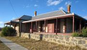
Coogee Hotel (fmr) is a rare example of a single-storey purpose built ‘honeymoon’ hotel, surviving in close to the city locations and is a surviving component of a precinct which was a destination for visitors and holiday makers for the first two decades of the 20th century Coogee Hotel (fmr) has significance as an Anglican children’s holiday camp from 1930 until the middle of World War II, after which it became a permanent children’s home from the end of World War II until 1967. Coogee Hotel (fmr) is a landmark on the coastal road between Fremantle and Rockingham.
Coogee Hotel (fmr) is a single-storey building of substantial limestone construction. It is set close to Cockburn Road on a cleared block of land. It is made from coursed limestone blocks with brick quoins. It features decorative stucco moulded arches on the front doors and windows. The roof is corrugated iron with a bull-nosed verandah shading three sides, supported by timber posts with ornamental capitals and timber corner brackets. The brick chimneys have moulded stucco tops. Recent adaptive works have added a sympathetic wing to the north of the building.
Coogee Hotel (fmr), one of the first hotels in the area, was built by Walter Powell in 1898. Powell was a trustee for the Coogee Agricultural Society and a member of the Fremantle District Roads Board from 1887-1900. Powell is said to have modelled the hotel on places he had seen along the French Riviera. It became a popular ‘watering hole’ visited by people after the long trip to Fremantle Markets. It was later patronised by customers who came by train. The hotel was the first stop from Fremantle for the stage coach on its way to Mandurah. The location of the hotel and its garden setting made it attractive to newlyweds and it became known as ‘the Honeymoon Hotel of WA’. It was well attended on Race Days as the Race Course was built next door. Powell encouraged attendance by offering substantial purses, the most prestigious being the Coogee Cup. When de-licensed (1930s) it remained vacant until 1942 when occupied by the Swan Anglican Children’s Home. It was again vacated when the home closed in 1967. In the 1970s it was home to the Coogee Progress Association. Coogee Hotel (fmr) has been recently renovated.
INTEGRITY: The integrity of the exterior of Coogee Hotel (fmr) is moderate due to recent adaptive works. The integrity of the interior of the original section of the Hotel is low due to recent adaptive works. AUTHENTICITY: The level of authenticity of the external fabric of the Hotel is moderate to high.
The place has been recently renovated and is in good condition.
| Ref ID No | Ref Name | Ref Source | Ref Date |
|---|---|---|---|
| HCWA assessment for Coogee Hotel and Post Office | State Heritage Office | ||
| M Berson; "The Making of a Community". | City of Cockburn | 1978 |
| Owner | Category |
|---|---|
| Commissioner of Main Roads | State Gov't |
This information is provided voluntarily as a public service. The information provided is made available in good faith and is derived from sources believed to be reliable and accurate. However, the information is provided solely on the basis that readers will be responsible for making their own assessment of the matters discussed herein and are advised to verify all relevant representations, statements and information.
The former hotel and post office/shop are of significance in that they are illustrative of the typical small settlements which once served the rural areas near Perth but which have gradually been engulfed by urban development. The two buildings have townscape value. They have a high degree of unity in terms of material and are well known and are a landmark along Cockburn Road. The buildings are of considerable local historical significance for the Coogee district. The Coogee hotel also has wider social historical value, it being renowned in its day as the Honeymooners Hotel.
The former Coogee Hotel is a single story limestone building (now painted) with brick quoins and decorative stucco mouldings around the main windows and the front door. It is roofed in corrugated iron and has brick chimneys with moulded stucco tops. It original had a bull-nosed corrugated iron verandah supported by timber posts with ornamental capitals and timber corner brackets. This has been replaced with a straight profile iron verandah supported by steel posts. Beneath the original front bar is a cellar (now closed off). A timber picket fence originally ran along the western elevation. Internally, the building retains many original details including the panelled doors, moulded skirtings and architraves and fireplaces. The structure has been extended a number of times. The present main hall, for example was originally a courtyard sheltered by grapevines. The courtyard between the hotel and the adjacent former Coogee Post Office had a horseshoe shaped turning facility for horses and carts. The Coogee Hotel was opened in 1091. It was built for Walter Powell, a prominent local identity who had been a member of the Fremantle District Road Board from 1887 – 1900, having served has its Chairman between 1893 and 1899. Powell is said to have modelled it on hotels he had seen in the French Riviera. The building was surrounded with gardens (including terraced lawns) and fountains and it soon became known as the “honeymoon Hotel of Western Australia”. Behind the hotel Powell built a race course and attracted patrons from Fremantle by presenting substantial tropheys. The Hotel was the first stop from Fremantle for the stage coach on its way to Mandurah. The hotel’s license was given up in about 1942 when it was occupied by the Saw Anglican Children’s Home. The building once again became vacant in 1967 when the Home closed and in 1969 it became the headquarters of the Coogee Progress Association. The former Coogee Post Office/shop is a single storey limestone structure with an attached weatherboard portion. A simple verandah is attached to the front/west elevation. Two window are symmetrically situated on either side of the front entrance door. These appear to have replaced earlier (and probably paned) windows. The weatherboard (residence) portion is a simple gable-ended structure with a brick chimney and corrugated iron roof. The Post Office/shop was built by Mr Jock McKinnon in about 1928. McKinnon was the brother-in-law of Walter Powell, builder of the adjoining Coogee hotel. It closed as a post office and shop and has since been used as a residence.
Assessment: 1988 comprising Fmr Coogee Hotel, 1901 & Former Coogee Post Office/Shop c.1928, limestone & weatherboard
This information is provided voluntarily as a public service. The information provided is made available in good faith and is derived from sources believed to be reliable and accurate. However, the information is provided solely on the basis that readers will be responsible for making their own assessment of the matters discussed herein and are advised to verify all relevant representations, statements and information.
358 Cockburn Rd Coogee
Lot 51
Cockburn
Metropolitan
| Type | Status | Date | Documents |
|---|---|---|---|
| Heritage List | Adopted | 14 Jul 2011 |
| Type | Status | Date | Documents |
|---|---|---|---|
| (no listings) |
| Type | Status | Date | Grading/Management | |
|---|---|---|---|---|
| Category | ||||
| Municipal Inventory | Adopted | 10 Apr 2014 | Category A | |
03648 Coogee Hotel (fmr)
Individual Building or Group
| Epoch | General | Specific |
|---|---|---|
| Original Use | Transport\Communications | Comms: Post or Telegraph Office |
| Present Use | RESIDENTIAL | Single storey residence |
| Type | General | Specific |
|---|---|---|
| Roof | METAL | Corrugated Iron |
| Wall | STONE | Limestone |
This information is provided voluntarily as a public service. The information provided is made available in good faith and is derived from sources believed to be reliable and accurate. However, the information is provided solely on the basis that readers will be responsible for making their own assessment of the matters discussed herein and are advised to verify all relevant representations, statements and information.
Constructed from 1928
Coogee Post Office (fmr) is representative of places which served the rural areas near Perth but which have gradually been engulfed by urban development. Coogee Post Office (fmr) has aesthetic value as a simple limestone building, with some landmark value on Cockburn Road.
Coogee Post Office (fmr) is situated close to Cockburn Road. The place is a single-storey structure, built using coursed smooth faced limestone with brick quoins. It has a symmetrical facade with two windows situated on either side of the front entrance door. It has an attached weatherboard portion at the rear. A simple verandah with a skillion roof is attached to the front (west) elevation. The roof of the front section is raked and the back section is gabled.
Now used as a residence, this old stone building and the Coogee Hotel are the earliest built in the area. The Post Office was built by Jock McKinnon around 1928. McKinnon was the brother-in-law of Walter Powell, the builder of the adjoining Coogee Hotel. There was a courtyard between the two buildings for turning horses and carts. This was not the first Post Office in the area. Originally the post was sorted and collected from a shop about a kilometre to the south of the Post Office building.
INTEGRITY: Integrity of the interior is low due to adaptive works. AUTHENTICITY: Moderate: much reduced by adaptive works
Good
| Ref ID No | Ref Name | Ref Source | Ref Date |
|---|---|---|---|
| HCWA assessment for Coogee Hotel and Post Office | State Heritage Office |
| Owner | Category |
|---|---|
| Commissioner of Main Roads | State Gov't |
This information is provided voluntarily as a public service. The information provided is made available in good faith and is derived from sources believed to be reliable and accurate. However, the information is provided solely on the basis that readers will be responsible for making their own assessment of the matters discussed herein and are advised to verify all relevant representations, statements and information.
361 Cockburn Rd Coogee
Explosive Magazine Watchman’s Residence
Naval Foreman's Residence (fmr)
Cockburn
Metropolitan
Constructed from 1913
| Type | Status | Date | Documents |
|---|---|---|---|
| (no listings) |
| Type | Status | Date | Documents |
|---|---|---|---|
| RHP - To be assessed | Current | 10 Sep 2021 |
| Type | Status | Date | Grading/Management | |
|---|---|---|---|---|
| Category | ||||
| Municipal Inventory | Adopted | 10 Apr 2014 | Category C | |
• The place is one of few surviving permanent structures erected as part of the Royal Australian Navy’s attempt to establish a strategic Commonwealth naval base at Woodman Point in the lead-up to WWI.
• The place is associated with the naval base foreman, E.P Henshaw (b.1870-d.1950), who also served as Member for Collie in the Legislative Assembly from June 1904 to October 1905.
• The place is associated with the historical use of the area as a reserve for explosives and munitions storage.
• The place is good representative example of an early twentieth century weatherboard and iron Federation Bungalow style residence.
The place is a good representative example of a weatherboard and iron Federation Bungalow residence, notable for its association with the historical use of the area as an explosives reserve. The place may be rare as one of few surviving permanent structures erected as part of the Royal Australian Navy’s attempt to establish a strategic Commonwealth naval base at Woodman Point in the lead-up to WWI.
A single storey timber and iron residence located on a rise at the northern end of a fenced work compound in an area of remnant Tuart Woodland near the eastern edge of Woodman Point Regional Park. Other buildings in the compound include a second timber and iron former residence (P16996 Residence, 377 Cockburn Road, Coogee), a large modern steel-framed carport, a large modern prefabricated steel shed, and some steel shipping containers. The place is of raised timber framed weatherboard construction and has a steeply pitched hipped gable roof, sheeted in corrugated galvanised iron. There are broken back verandahs on the eastern and western sides and a prominent gable wing projection on the northern side. Verandahs are supported on stop-chamfered posts and have natural Jarrah floors. Rafter ends are exposed and there are no gutters or downpipes. Two red brick corbelled chimneys rise from the main roof on the northern and southern sides. A full height box bay window defines the main entrance, from the verandah, on the eastern side, and there is a second box bay window on the southern side. Windows are painted timber, fitted with either casements or double hung sliding sashes. Bay windows feature stopped ovolo moulded details and patterned coloured toplights. Internally, there are six main rooms, which have carpeted timber floors, painted plasterboard or horizontal beaded tongue and groove timber wall linings and painted beaded tongue and groove ceiling linings. Walls have plasterboard or vertically planked beaded tongue and groove wainscot panelling. Other interior features include decorative ceiling roses, timber mantles and fireplace surrounds, built-in timber seating and decorative timber fretwork to box bay windows, and a cast iron Metters No. 2 wood stove in the Kitchen. The place is in poor condition, with extensive termite damage to timber trims and linings. On the southern side, some window sashes have dislodged from their openings and the southern box bay window has partially collapsed. Asbestos-containing linings have recently been removed from verandah walls, ceilings and balustrades, leaving substrates exposed.
The Aboriginal group of the Cockburn area are the Beeliar Nyoongar, part of the Whadjuk Aboriginal people of the Perth metropolitan area. Traditionally they lived alongside the area’s fresh water lake and wetland system, establishing semi-permanent campsites, trails and trade activity routes in the area. Woodman Point and Cockburn Road are among several culturally significant Aboriginal heritage sites recorded in the vicinity of P16995 Residence, 361 Cockburn Road, Coogee. The Beeliar Nyoongar way of life was disrupted from 1829, with the arrival of British colonists to the Swan River colony. The first settlements were established at Fremantle, Guildford and Perth, followed by Clarence south of Fremantle, in December 1829. The Clarence settlement failed to thrive and by November 1830 the original camp settlement was virtually deserted. The 1836 gazettal of Clarence townsite captured most of the Woodman Point peninsular including the future site of Residence, 361 Cockburn Road, Coogee. During the nineteenth century the place remained isolated from settled areas and underwent minimal development. By 1903/04 the place was captured within Reserve 8907, a 327-acre land parcel set aside for the State Department of Mines as a Reserve for Explosives. One fifth of the reserve was allocated for future use and the remainder enclosed by an 8ft high galvanised iron fence. A timber jetty was constructed (P10183 Munitions Jetty) and, within the enclosure, sites were laid out for explosives storage magazines and detonator magazines. The existing railway main line was extended southwards to the reserve, with parallel spurs constructed within the enclosure to service the magazine sites. Around 1910, British Admiral Sir Reginald Henderson was invited by the Commonwealth Government to visit Australia and provide advice on naval defence and infrastructure . In his report to the Commonwealth, issued on 1 March 1911, Henderson emphasised the strategic importance of Fremantle (Cockburn Sound) as the Western Fleet Primary Base , outlining special requirements for immediate dredging, surveying and land reservation works as part of the Initial Stage (1911-1918) to establish the base. On 20 January 1913 naval base foreman, Mr Henshaw, was appointed and on 28 December 1916, Reserve 8907 was compulsorily acquired by the Commonwealth Government for defence purposes. Ernest Percival Henshaw (b.1870, d.1950) arrived in Western Australia from Victoria around 1894. The son of a cabinet maker, he settled in Subiaco, working as a carpenter and joiner. Active in the labour movement, he held numerous official positions in the Australian Labor Party, including a seat in the Western Australian Legislative Assembly from June 1904 to October 1905. Prior to his appointment as the naval base foreman, Henshaw supervised construction works for the new Trades Hall building (P08783 Perth Trades Hall), completed in 1912. By 1913, preliminary work on the naval base was already “…well advanced, and six square miles of sea and land have been thoroughly surveyed” and on 7 May 1913 the State Minister for Defence, Senator G.F. Pearce, performed an opening ceremony, formally naming it Henderson Fleet Base . By August 1913, construction of Residence, 361 Cockburn Road, Coogee and a second residence (P16996 Residence 377 Cockburn Road, Coogee) had commenced. An illustrated newspaper article provides the following description: "A little bit up the hill….there is a scene of activity, for here two fine residences are being built, and the carpenters of the Base seem to have been all concentrated on this work. The nearest house to the Base is a six-roomed jarrah and iron house, with Bungalow verandah on two sides. This is the naval foreman (a billet at present filled by Mr Henshaw). The other is a larger house, having eight rooms and a kitchen, and this is for the engineer-in-charge (Mr Walkenden). There is nothing of a temporary nature about these buildings…and notwithstanding that other work has been stopped, the erection of these buildings (which is purely and simply for the comfort of the officers) is apparently being treated as a matter of urgency. The vicinity of these buildings is the centre of the greatest activity on the whole Base..” A short time later WWI intervened, halting further construction on the naval base until the project was officially abandoned by the Commonwealth in 1923. On 13 October 1927 Reserve 8907 was transferred back to the State. Between the wars, the two houses were used as private residences . During WWII, Woodman Point came under the control of the Naval Department of the Commonwealth Government, with no civilian access to the site. In 1941, three brick ‘standard design cordite and ammunition magazines’ were constructed within the reserve (P4626 Munitions Magazines (fmr) Woodman Point) and the houses were used as naval officers’ quarters during this period. On 15 October 1945, Woodman Point passed back into the control of the State government, who re-established an explosives storage depot within the reserve. The depot continued to operate from the Woodman Point site until its relocation to a new facility in Baldivis in 1984. During this time the houses were used as private residences for explosives magazine watchmen. From 1984 the reserve came under an interim management arrangement before being formally vested with the National Parks and Nature Conservation Authority (now the Conservation Commission of Western Australia) after 1997 as part Woodman Point Regional Park. Up until the late 1990s, the houses were used as private residences for park rangers, after which Residence, 361 Cockburn Road, Coogee was vacated and the southern residence (P16996 Residence, 377 Cockburn Road, Coogee) adapted for use as a regional park office. In August 2021, both houses are managed by the Department of Biodiversity, Conservation and Attractions (DBCA) as part of a Parks and Wildlife work centre, with the southern residence still in use as an office and the subject place vacant.
Integrity - High Authenticity - Medium
Fair
Individual Building or Group
| Epoch | General | Specific |
|---|---|---|
| Present Use | VACANT\UNUSED | Vacant\Unused |
| Original Use | RESIDENTIAL | Single storey residence |
| Style |
|---|
| Federation Bungalow |
| Type | General | Specific |
|---|---|---|
| Wall | TIMBER | Weatherboard |
| Roof | METAL | Corrugated Iron |
| General | Specific |
|---|---|
| OUTSIDE INFLUENCES | World Wars & other wars |
| OCCUPATIONS | Mining {incl. mineral processing} |
| DEMOGRAPHIC SETTLEMENT & MOBILITY | Resource exploitation & depletion |
| OTHER | Other Sub-Theme |
This information is provided voluntarily as a public service. The information provided is made available in good faith and is derived from sources believed to be reliable and accurate. However, the information is provided solely on the basis that readers will be responsible for making their own assessment of the matters discussed herein and are advised to verify all relevant representations, statements and information.
Constructed from 1914
Watchman’s Residence (fmr) is a good example of Federation Carpenter architectural style. Watchman’s Residence (fmr) reflects a long association with the development of Woodman Point first as a potential Naval base and then as a place for storing explosives.
The place is set back above Cockburn Road on a rise. It is raised on stumps and set on large property, now used as Woodman Point Work Centre for the Department of Conservation. The former residence is a Federation Carpenter style building with timber walls, and a projecting gabled wing with prominent bay window. It has two brick chimneys, a steeply-pitched gabled corrugated iron roof, and a broken-back roof shades the front verandah.
In 1910 the Commonwealth Government chose the Cockburn Sound anchorage as an important strategic site for a naval base. In 1913 land was acquired for this purpose. Some construction work and much planning took place. Amongst the work completed were the two houses on Cockburn Road. Around 1914 the Australian Navy built the residences on Cockburn Road for Officer quarters. However, World War I intervened and plans for the Naval Base collapsed. The project was officially abandoned in 1918. Between the Wars the two houses were private residences. There may be link between these residences and Woodman Point Quarantine Station as it is thought a doctor from the station lived in one of the houses in the interwar period. During World War II the houses again became Officer quarters. The officers who lived at the houses were in charge of the Submarine Base. After the war the houses were used as residences for the watchmen of the Explosive Magazine. The Explosive magazine had been established on Woodman’s Point (now Woodman Point) alongside the Quarantine Station in 1903-04. The purpose of the magazine was to store, sample and test explosives being imported into the state. In the 1970s the government recognised the recreational potential of Woodman Point and the location of the Explosive Magazine was no longer appropriate. The Explosives Magazine was vacated in 1982 with all explosives transferred to the new magazine at Baldivis. The former watchmen’s houses on Cockburn road became the homes of the Sports and Recreation rangers in 1984. In 1998 Sports and Recreation transferred control of the reserve to CALM (now Department of Conservation), and in 2011 the residences are part of Woodman Point Work Centre.
INTEGRITY: High AUTHENTICITY: High
Good
| Ref ID No | Ref Name | Ref Source | Ref Date |
|---|---|---|---|
| Interview with Lyle Woods, CALM ranger residing in place. | 19/7/1999 | ||
| I Molyneaux; "Woodman Point Conservation Plan". | Molyneaux & Associates Architects. | June 1995 | |
| Transfield Maintenance report. | CALM | 1999 | |
| Interview with Russell Park, Department of Minerals and Energy, | 19/7/1999 | ||
| Interview with Kim Lawrence, fmr manager of Woodman Point Sports and Recreation Camp, | 19/7/1999 |
This information is provided voluntarily as a public service. The information provided is made available in good faith and is derived from sources believed to be reliable and accurate. However, the information is provided solely on the basis that readers will be responsible for making their own assessment of the matters discussed herein and are advised to verify all relevant representations, statements and information.
371 Cockburn Rd Coogee
note that construction date is incorrect in Register documentation. Correct date is 1898.
Coogee Progress Association
Old Coogee Hotel
Powell’s Coogee Hotel
Swan Anglican Children’s Home
Cockburn
Metropolitan
Constructed from 1898 to 1990
| Type | Status | Date | Documents |
|---|---|---|---|
| Heritage Agreement | YES | 16 Jan 2018 | HCWebsite.Listing+ListingDocument |
| Heritage List | Adopted | 10 Apr 2014 | |
| State Register | Registered | 14 May 2002 | HCWebsite.Listing+ListingDocument, HCWebsite.Listing+ListingDocument |
| Type | Status | Date | Documents |
|---|---|---|---|
| (no listings) |
| Type | Status | Date | Grading/Management | |
|---|---|---|---|---|
| Category | ||||
| Statewide Hotel Survey | Completed | 01 Nov 1997 | ||
| Register of the National Estate | Indicative Place | |||
| Classified by the National Trust | Classified | 02 May 1988 | ||
| Register of the National Estate | Nominated | 19 Feb 1991 | ||
| Municipal Inventory | Adopted | 01 Nov 2012 | Category A | |
| Library Id | Title | Medium | Year Of Publication |
|---|---|---|---|
| 5443 | Coogee Hotel and Post Office : future use study. | Report | 2000 |
| 11754 | Coogee Hotel and Post Office | Electronic | 2017 |
| 6779 | Coogee Hotel and Post Office : schedule of conservation and refurbishment works + costed schedule. | Conservation works report | 2002 |
| 10291 | A report on an archaeological excavation of the former Coogee Hotel and Post Office site. Cockburn Road, Coogee | Electronic | 2006 |
| 4308 | Coogee Hotel and Post Office : conservation plan. | Heritage Study {Cons'n Plan} | 1999 |
| 6992 | Old Coogee Hotel & Post Office : conservation works and specification. | Conservation works report | 2004 |
Individual Building or Group
| Epoch | General | Specific |
|---|---|---|
| Original Use | Transport\Communications | Comms: Post or Telegraph Office |
| Original Use | RESIDENTIAL | Institutional Housing |
| Original Use | COMMERCIAL | Hotel, Tavern or Inn |
| Other Use | SOCIAL\RECREATIONAL | Other |
| Style |
|---|
| Federation Free Classical |
| Type | General | Specific |
|---|---|---|
| Roof | METAL | Corrugated Iron |
| Wall | STONE | Limestone |
| General | Specific |
|---|---|
| OCCUPATIONS | Hospitality industry & tourism |
| SOCIAL & CIVIC ACTIVITIES | Sport, recreation & entertainment |
| TRANSPORT & COMMUNICATIONS | Mail services |
This information is provided voluntarily as a public service. The information provided is made available in good faith and is derived from sources believed to be reliable and accurate. However, the information is provided solely on the basis that readers will be responsible for making their own assessment of the matters discussed herein and are advised to verify all relevant representations, statements and information.
Coogee Hotel (fmr) is a rare example of a single-storey purpose built ‘honeymoon’ hotel, surviving in close to the city locations and is a surviving component of a precinct which was a destination for visitors and holiday makers for the first two decades of the 20th century. Coogee Hotel (fmr) has significance as an Anglican children’s holiday camp from 1930 until the middle of World War II, after which it became a permanent children’s home from the end of World War II until 1967. Coogee Hotel (fmr) is a landmark on the coastal road between Fremantle and Rockingham. Coogee Post Office (fmr) is representative of places which served the rural areas near Perth but which have gradually been engulfed by urban development. Coogee Post Office (fmr) has aesthetic value as a simple limestone building, with some landmark value on Cockburn Road.
Coogee Hotel (fmr) is a single-storey building of substantial limestone construction. It is set close to Cockburn Road on a cleared block of land. It is made from coursed limestone blocks with brick quoins. It features decorative stucco moulded arches on the front doors and windows. The roof is corrugated iron with a bull-nosed verandah shading three sides, supported by timber posts with ornamental capitals and timber corner brackets. The brick chimneys have moulded stucco tops. Recent adaptive works have added a sympathetic wing to the north of the building.
Coogee Hotel (fmr), one of the first hotels in the area, was built by Walter Powell in 1898. Powell was a trustee for the Coogee Agricultural Society and a member of the Fremantle District Roads Board from 1887-1900. Powell is said to have modelled the hotel on places he had seen along the French Riviera. It became a popular ‘watering hole’ visited by people after the long trip to Fremantle Markets. It was later patronised by customers who came by train. The hotel was the first stop from Fremantle for the stage coach on its way to Mandurah. The location of the hotel and its garden setting made it attractive to newlyweds and it became known as ‘the Honeymoon Hotel of WA’. It was well attended on Race Days as the Race Course was built next door. Powell encouraged attendance by offering substantial purses, the most prestigious being the Coogee Cup. When de-licensed (1930s) it remained vacant until 1942 when occupied by the Swan Anglican Children’s Home. It was again vacated when the home closed in 1967. In the 1970s it was home to the Coogee Progress Association.
INTEGRITY: Moderate AUTHENTICITY: High
Good
This information is provided voluntarily as a public service. The information provided is made available in good faith and is derived from sources believed to be reliable and accurate. However, the information is provided solely on the basis that readers will be responsible for making their own assessment of the matters discussed herein and are advised to verify all relevant representations, statements and information.
377 Cockburn Rd Coogee
Explosive Magazine Watchman’s Residence
Naval Engineer's Residence
Cockburn
Metropolitan
Constructed from 1913
| Type | Status | Date | Documents |
|---|---|---|---|
| (no listings) |
| Type | Status | Date | Documents |
|---|---|---|---|
| RHP - To be assessed | Current | 10 Sep 2021 |
| Type | Status | Date | Grading/Management | |
|---|---|---|---|---|
| Category | ||||
| Municipal Inventory | Adopted | 10 Apr 2014 | Category C | |
The place is a good representative example of a weatherboard and iron Federation Bungalow residence, notable for its association the historical use of the area as an explosives reserve, and which may be rare as one of few surviving permanent structures erected as part of the Royal Australian Navy’s attempt to establish a strategic Commonwealth naval base at Woodman Point in the lead-up to WWI.
The place comprises a single-story weatherboard and iron Federation Bungalow residence situated amongst mature Tuart trees within a regional park works centre. Another single-storey residence of similar style and construction (P16995 Residence, 361 Cockburn Road, Coogee) is located near the northern boundary of the work centre. Other buildings in the compound include a large modern steel-framed carport, a large modern prefabricated steel shed, some steel shipping containers. The place is in good condition.
The Aboriginal group of the Cockburn area are the Beeliar Nyoongar, part of the Whadjuk Aboriginal people of the Perth metropolitan area. Traditionally they lived alongside the area’s fresh water lake and wetland system, establishing semi-permanent campsites, trails and trade activity routes in the area. Woodman Point and Cockburn Road are among several culturally significant Aboriginal heritage sites recorded in the vicinity of P16995 Residence, 361 Cockburn Road, Coogee. The Beeliar Nyoongar way of life was disrupted from 1829, with the arrival of British colonists to the Swan River colony. The first settlements were established at Fremantle, Guildford and Perth, followed by Clarence south of Fremantle, in December 1829. The Clarence settlement failed to thrive and by November 1830 the original camp settlement was virtually deserted. The 1836 gazettal of Clarence townsite captured most of the Woodman Point peninsular including the future site of Residence, 361 Cockburn Road, Coogee. During the nineteenth century the place remained isolated from settled areas and underwent minimal development. By 1903/04 the place was captured within Reserve 8907, a 327-acre land parcel set aside for the State Department of Mines as a Reserve for Explosives. One fifth of the reserve was allocated for future use and the remainder enclosed by an 8ft high galvanised iron fence. A timber jetty was constructed (P10183 Munitions Jetty) and, within the enclosure, sites were laid out for explosives storage magazines and detonator magazines. The existing railway main line was extended southwards to the reserve, with parallel spurs constructed within the enclosure to service the magazine sites. Around 1910, British Admiral Sir Reginald Henderson was invited by the Commonwealth Government to visit Australia and provide advice on naval defence and infrastructure . In his report to the Commonwealth, issued on 1 March 1911, Henderson emphasised the strategic importance of Fremantle (Cockburn Sound) as the Western Fleet Primary Base , outlining special requirements for immediate dredging, surveying and land reservation works as part of the Initial Stage (1911-1918) to establish the base. On 20 January 1913 naval base foreman, Mr Henshaw, was appointed and on 28 December 1916, Reserve 8907 was compulsorily acquired by the Commonwealth Government for defence purposes. Ernest Percival Henshaw (b.1870, d.1950) arrived in Western Australia from Victoria around 1894. The son of a cabinet maker, he settled in Subiaco, working as a carpenter and joiner. Active in the labour movement, he held numerous official positions in the Australian Labor Party, including a seat in the Western Australian Legislative Assembly from June 1904 to October 1905. Prior to his appointment as the naval base foreman, Henshaw supervised construction works for the new Trades Hall building (P08783 Perth Trades Hall), completed in 1912. By 1913, preliminary work on the naval base was already “…well advanced, and six square miles of sea and land have been thoroughly surveyed” and on 7 May 1913 the State Minister for Defence, Senator G.F. Pearce, performed an opening ceremony, formally naming it Henderson Fleet Base . By August 1913, construction of Residence, 361 Cockburn Road, Coogee and a second residence (P16996 Residence 377 Cockburn Road, Coogee) had commenced. An illustrated newspaper article provides the following description: "A little bit up the hill….there is a scene of activity, for here two fine residences are being built, and the carpenters of the Base seem to have been all concentrated on this work. The nearest house to the Base is a six-roomed jarrah and iron house, with Bungalow verandah on two sides. This is the naval foreman (a billet at present filled by Mr Henshaw). The other is a larger house, having eight rooms and a kitchen, and this is for the engineer-in-charge (Mr Walkenden). There is nothing of a temporary nature about these buildings…and notwithstanding that other work has been stopped, the erection of these buildings (which is purely and simply for the comfort of the officers) is apparently being treated as a matter of urgency. The vicinity of these buildings is the centre of the greatest activity on the whole Base..” A short time later WWI intervened, halting further construction on the naval base until the project was officially abandoned by the Commonwealth in 1923. On 13 October 1927 Reserve 8907 was transferred back to the State. Between the wars, the two houses were used as private residences . During WWII, Woodman Point came under the control of the Naval Department of the Commonwealth Government, with no civilian access to the site. In 1941, three brick ‘standard design cordite and ammunition magazines’ were constructed within the reserve (P4626 Munitions Magazines (fmr) Woodman Point) and the houses were used as naval officers’ quarters during this period. On 15 October 1945, Woodman Point passed back into the control of the State government, who re-established an explosives storage depot within the reserve. The depot continued to operate from the Woodman Point site until its relocation to a new facility in Baldivis in 1984. During this time the houses were used as private residences for explosives magazine watchmen. From 1984 the reserve came under an interim management arrangement before being formally vested with the National Parks and Nature Conservation Authority (now the Conservation Commission of Western Australia) after 1997 as part Woodman Point Regional Park. Up until the late 1990s, the houses were used as private residences for park rangers, after which Residence, 361 Cockburn Road, Coogee was vacated and the southern residence (P16996 Residence, 377 Cockburn Road, Coogee) adapted for use as a regional park office. In August 2021, both houses are managed by the Department of Biodiversity, Conservation and Attractions (DBCA) as part of a Parks and Wildlife work centre, with the southern residence still in use as an office and the subject place vacant.
Integrity - High Authenticity - Medium
Fair to Good.
Individual Building or Group
| Epoch | General | Specific |
|---|---|---|
| Present Use | GOVERNMENTAL | Office or Administration Bldg |
| Original Use | RESIDENTIAL | Single storey residence |
| Style |
|---|
| Federation Bungalow |
| Type | General | Specific |
|---|---|---|
| Roof | METAL | Corrugated Iron |
| Wall | TIMBER | Weatherboard |
| General | Specific |
|---|---|
| OUTSIDE INFLUENCES | World Wars & other wars |
| DEMOGRAPHIC SETTLEMENT & MOBILITY | Resource exploitation & depletion |
| OCCUPATIONS | Mining {incl. mineral processing} |
| OTHER | Other Sub-Theme |
This information is provided voluntarily as a public service. The information provided is made available in good faith and is derived from sources believed to be reliable and accurate. However, the information is provided solely on the basis that readers will be responsible for making their own assessment of the matters discussed herein and are advised to verify all relevant representations, statements and information.
Constructed from 1914
Watchman’s Residence (fmr) is a good example of Federation Carpenter architectural style. Watchman’s Residence (fmr) reflects a long association with the development of Woodman Point first as a potential Naval base and then as a place for storing explosives.
The place is set back above Cockburn Road on a rise. It is raised on stumps and set on large property, now used as Woodman Point Work Centre for the Department of Conservation. The former residence is a Federation Carpenter style building with timber walls, and a projecting gabled wing with prominent bay window. It has two brick chimneys, a steeply-pitched gabled corrugated iron roof, and a broken-back roof shades the front verandah.
In 1910 the Commonwealth Government chose the Cockburn Sound anchorage as an important strategic site for a naval base. In 1913 land was acquired for this purpose. Some construction work and much planning took place. Amongst the work completed were the two houses on Cockburn Road. Around 1914 the Australian Navy built the residences on Cockburn Road for Officer quarters. However, World War I intervened and plans for the Naval Base collapsed. The project was officially abandoned in 1918. Between the Wars the two houses were private residences. There may be link between these residences and Woodman Point Quarantine Station as it is thought a doctor from the station lived in one of the houses in the interwar period. During World War II the houses again became Officer quarters. The officers who lived at the houses were in charge of the Submarine Base. After the war the houses were used as residences for the watchmen of the Explosive Magazine. The Explosive magazine had been established on Woodman’s Point (now Woodman Point) alongside the Quarantine Station in 1903-04. The purpose of the magazine was to store, sample and test explosives being imported into the state. In the 1970s the government recognised the recreational potential of Woodman Point and the location of the Explosive Magazine was no longer appropriate. The Explosives Magazine was vacated in 1982 with all explosives transferred to the new magazine at Baldivis. The former watchmen’s houses on Cockburn road became the homes of the Sports and Recreation rangers in 1984. In 1998 Sports and Recreation transferred control of the reserve to CALM (now Department of Conservation), and in 2011 the residences are part of Woodman Point Work Centre.
INTEGRITY: High AUTHENTICITY: High
Good
| Ref ID No | Ref Name | Ref Source | Ref Date |
|---|---|---|---|
| Interview with Lyle Woods, CALM ranger residing in place. | 19/7/1999 | ||
| Interview with Russell Park, Department of Minerals and Energy, | 19/7/1999 | ||
| "Transfield Maintenance report". | CALM | 1999 | |
| Interview with Kim Lawrence, fmr manager of Woodman Point Sports and Recreation Camp. | 19/7/1999 | ||
| I Molyneaux; "Woodman Point Conservation Plan". | Molyneaux & Associates Architects. | 1995 |
This information is provided voluntarily as a public service. The information provided is made available in good faith and is derived from sources believed to be reliable and accurate. However, the information is provided solely on the basis that readers will be responsible for making their own assessment of the matters discussed herein and are advised to verify all relevant representations, statements and information.