Local Government
Cockburn
Region
Metropolitan
358 Cockburn Rd Coogee
Cockburn
Metropolitan
| Type | Status | Date | Documents |
|---|---|---|---|
| Heritage List | Adopted | 14 Jul 2011 |
| Type | Status | Date | Documents |
|---|---|---|---|
| (no listings) |
| Type | Status | Date | Grading/Management | |
|---|---|---|---|---|
| Category | ||||
| Municipal Inventory | Adopted | 15 Apr 1997 | Category A | |
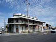
03648 Coogee Hotel (fmr)
Individual Building or Group
| Epoch | General | Specific |
|---|---|---|
| Original Use | COMMERCIAL | Hotel, Tavern or Inn |
This information is provided voluntarily as a public service. The information provided is made available in good faith and is derived from sources believed to be reliable and accurate. However, the information is provided solely on the basis that readers will be responsible for making their own assessment of the matters discussed herein and are advised to verify all relevant representations, statements and information.
Constructed from 1898
Coogee Hotel (fmr) is a rare example of a single-storey purpose built ‘honeymoon’ hotel, surviving in close to the city locations and is a surviving component of a precinct which was a destination for visitors and holiday makers for the first two decades of the 20th century Coogee Hotel (fmr) has significance as an Anglican children’s holiday camp from 1930 until the middle of World War II, after which it became a permanent children’s home from the end of World War II until 1967. Coogee Hotel (fmr) is a landmark on the coastal road between Fremantle and Rockingham.
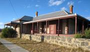
Coogee Hotel (fmr) is a single-storey building of substantial limestone construction. It is set close to Cockburn Road on a cleared block of land. It is made from coursed limestone blocks with brick quoins. It features decorative stucco moulded arches on the front doors and windows. The roof is corrugated iron with a bull-nosed verandah shading three sides, supported by timber posts with ornamental capitals and timber corner brackets. The brick chimneys have moulded stucco tops. Recent adaptive works have added a sympathetic wing to the north of the building.
Coogee Hotel (fmr), one of the first hotels in the area, was built by Walter Powell in 1898. Powell was a trustee for the Coogee Agricultural Society and a member of the Fremantle District Roads Board from 1887-1900. Powell is said to have modelled the hotel on places he had seen along the French Riviera. It became a popular ‘watering hole’ visited by people after the long trip to Fremantle Markets. It was later patronised by customers who came by train. The hotel was the first stop from Fremantle for the stage coach on its way to Mandurah. The location of the hotel and its garden setting made it attractive to newlyweds and it became known as ‘the Honeymoon Hotel of WA’. It was well attended on Race Days as the Race Course was built next door. Powell encouraged attendance by offering substantial purses, the most prestigious being the Coogee Cup. When de-licensed (1930s) it remained vacant until 1942 when occupied by the Swan Anglican Children’s Home. It was again vacated when the home closed in 1967. In the 1970s it was home to the Coogee Progress Association. Coogee Hotel (fmr) has been recently renovated.
INTEGRITY: The integrity of the exterior of Coogee Hotel (fmr) is moderate due to recent adaptive works. The integrity of the interior of the original section of the Hotel is low due to recent adaptive works. AUTHENTICITY: The level of authenticity of the external fabric of the Hotel is moderate to high.
The place has been recently renovated and is in good condition.
| Ref ID No | Ref Name | Ref Source | Ref Date |
|---|---|---|---|
| HCWA assessment for Coogee Hotel and Post Office | State Heritage Office | ||
| M Berson; "The Making of a Community". | City of Cockburn | 1978 |
| Owner | Category |
|---|---|
| Commissioner of Main Roads | State Gov't |
This information is provided voluntarily as a public service. The information provided is made available in good faith and is derived from sources believed to be reliable and accurate. However, the information is provided solely on the basis that readers will be responsible for making their own assessment of the matters discussed herein and are advised to verify all relevant representations, statements and information.
The former hotel and post office/shop are of significance in that they are illustrative of the typical small settlements which once served the rural areas near Perth but which have gradually been engulfed by urban development. The two buildings have townscape value. They have a high degree of unity in terms of material and are well known and are a landmark along Cockburn Road. The buildings are of considerable local historical significance for the Coogee district. The Coogee hotel also has wider social historical value, it being renowned in its day as the Honeymooners Hotel.
The former Coogee Hotel is a single story limestone building (now painted) with brick quoins and decorative stucco mouldings around the main windows and the front door. It is roofed in corrugated iron and has brick chimneys with moulded stucco tops. It original had a bull-nosed corrugated iron verandah supported by timber posts with ornamental capitals and timber corner brackets. This has been replaced with a straight profile iron verandah supported by steel posts. Beneath the original front bar is a cellar (now closed off). A timber picket fence originally ran along the western elevation. Internally, the building retains many original details including the panelled doors, moulded skirtings and architraves and fireplaces. The structure has been extended a number of times. The present main hall, for example was originally a courtyard sheltered by grapevines. The courtyard between the hotel and the adjacent former Coogee Post Office had a horseshoe shaped turning facility for horses and carts. The Coogee Hotel was opened in 1091. It was built for Walter Powell, a prominent local identity who had been a member of the Fremantle District Road Board from 1887 – 1900, having served has its Chairman between 1893 and 1899. Powell is said to have modelled it on hotels he had seen in the French Riviera. The building was surrounded with gardens (including terraced lawns) and fountains and it soon became known as the “honeymoon Hotel of Western Australia”. Behind the hotel Powell built a race course and attracted patrons from Fremantle by presenting substantial tropheys. The Hotel was the first stop from Fremantle for the stage coach on its way to Mandurah. The hotel’s license was given up in about 1942 when it was occupied by the Saw Anglican Children’s Home. The building once again became vacant in 1967 when the Home closed and in 1969 it became the headquarters of the Coogee Progress Association. The former Coogee Post Office/shop is a single storey limestone structure with an attached weatherboard portion. A simple verandah is attached to the front/west elevation. Two window are symmetrically situated on either side of the front entrance door. These appear to have replaced earlier (and probably paned) windows. The weatherboard (residence) portion is a simple gable-ended structure with a brick chimney and corrugated iron roof. The Post Office/shop was built by Mr Jock McKinnon in about 1928. McKinnon was the brother-in-law of Walter Powell, builder of the adjoining Coogee hotel. It closed as a post office and shop and has since been used as a residence.
Assessment: 1988 comprising Fmr Coogee Hotel, 1901 & Former Coogee Post Office/Shop c.1928, limestone & weatherboard
This information is provided voluntarily as a public service. The information provided is made available in good faith and is derived from sources believed to be reliable and accurate. However, the information is provided solely on the basis that readers will be responsible for making their own assessment of the matters discussed herein and are advised to verify all relevant representations, statements and information.
358 Cockburn Rd Coogee
Lot 51
Cockburn
Metropolitan
| Type | Status | Date | Documents |
|---|---|---|---|
| Heritage List | Adopted | 14 Jul 2011 |
| Type | Status | Date | Documents |
|---|---|---|---|
| (no listings) |
| Type | Status | Date | Grading/Management | |
|---|---|---|---|---|
| Category | ||||
| Municipal Inventory | Adopted | 10 Apr 2014 | Category A | |
03648 Coogee Hotel (fmr)
Individual Building or Group
| Epoch | General | Specific |
|---|---|---|
| Original Use | Transport\Communications | Comms: Post or Telegraph Office |
| Present Use | RESIDENTIAL | Single storey residence |
| Type | General | Specific |
|---|---|---|
| Roof | METAL | Corrugated Iron |
| Wall | STONE | Limestone |
This information is provided voluntarily as a public service. The information provided is made available in good faith and is derived from sources believed to be reliable and accurate. However, the information is provided solely on the basis that readers will be responsible for making their own assessment of the matters discussed herein and are advised to verify all relevant representations, statements and information.
Constructed from 1928
Coogee Post Office (fmr) is representative of places which served the rural areas near Perth but which have gradually been engulfed by urban development. Coogee Post Office (fmr) has aesthetic value as a simple limestone building, with some landmark value on Cockburn Road.
Coogee Post Office (fmr) is situated close to Cockburn Road. The place is a single-storey structure, built using coursed smooth faced limestone with brick quoins. It has a symmetrical facade with two windows situated on either side of the front entrance door. It has an attached weatherboard portion at the rear. A simple verandah with a skillion roof is attached to the front (west) elevation. The roof of the front section is raked and the back section is gabled.
Now used as a residence, this old stone building and the Coogee Hotel are the earliest built in the area. The Post Office was built by Jock McKinnon around 1928. McKinnon was the brother-in-law of Walter Powell, the builder of the adjoining Coogee Hotel. There was a courtyard between the two buildings for turning horses and carts. This was not the first Post Office in the area. Originally the post was sorted and collected from a shop about a kilometre to the south of the Post Office building.
INTEGRITY: Integrity of the interior is low due to adaptive works. AUTHENTICITY: Moderate: much reduced by adaptive works
Good
| Ref ID No | Ref Name | Ref Source | Ref Date |
|---|---|---|---|
| HCWA assessment for Coogee Hotel and Post Office | State Heritage Office |
| Owner | Category |
|---|---|
| Commissioner of Main Roads | State Gov't |
This information is provided voluntarily as a public service. The information provided is made available in good faith and is derived from sources believed to be reliable and accurate. However, the information is provided solely on the basis that readers will be responsible for making their own assessment of the matters discussed herein and are advised to verify all relevant representations, statements and information.
371 Cockburn Rd Coogee
note that construction date is incorrect in Register documentation. Correct date is 1898.
Coogee Progress Association
Old Coogee Hotel
Powell’s Coogee Hotel
Swan Anglican Children’s Home
Cockburn
Metropolitan
Constructed from 1898 to 1990
| Type | Status | Date | Documents |
|---|---|---|---|
| Heritage Agreement | YES | 16 Jan 2018 | HCWebsite.Listing+ListingDocument |
| Heritage List | Adopted | 10 Apr 2014 | |
| State Register | Registered | 14 May 2002 | HCWebsite.Listing+ListingDocument, HCWebsite.Listing+ListingDocument |
| Type | Status | Date | Documents |
|---|---|---|---|
| (no listings) |
| Type | Status | Date | Grading/Management | |
|---|---|---|---|---|
| Category | ||||
| Statewide Hotel Survey | Completed | 01 Nov 1997 | ||
| Register of the National Estate | Indicative Place | |||
| Classified by the National Trust | Classified | 02 May 1988 | ||
| Register of the National Estate | Nominated | 19 Feb 1991 | ||
| Municipal Inventory | Adopted | 01 Nov 2012 | Category A | |
| Library Id | Title | Medium | Year Of Publication |
|---|---|---|---|
| 5443 | Coogee Hotel and Post Office : future use study. | Report | 2000 |
| 11754 | Coogee Hotel and Post Office | Electronic | 2017 |
| 6779 | Coogee Hotel and Post Office : schedule of conservation and refurbishment works + costed schedule. | Conservation works report | 2002 |
| 10291 | A report on an archaeological excavation of the former Coogee Hotel and Post Office site. Cockburn Road, Coogee | Electronic | 2006 |
| 4308 | Coogee Hotel and Post Office : conservation plan. | Heritage Study {Cons'n Plan} | 1999 |
| 6992 | Old Coogee Hotel & Post Office : conservation works and specification. | Conservation works report | 2004 |
Individual Building or Group
| Epoch | General | Specific |
|---|---|---|
| Original Use | Transport\Communications | Comms: Post or Telegraph Office |
| Original Use | RESIDENTIAL | Institutional Housing |
| Original Use | COMMERCIAL | Hotel, Tavern or Inn |
| Other Use | SOCIAL\RECREATIONAL | Other |
| Style |
|---|
| Federation Free Classical |
| Type | General | Specific |
|---|---|---|
| Roof | METAL | Corrugated Iron |
| Wall | STONE | Limestone |
| General | Specific |
|---|---|
| OCCUPATIONS | Hospitality industry & tourism |
| SOCIAL & CIVIC ACTIVITIES | Sport, recreation & entertainment |
| TRANSPORT & COMMUNICATIONS | Mail services |
This information is provided voluntarily as a public service. The information provided is made available in good faith and is derived from sources believed to be reliable and accurate. However, the information is provided solely on the basis that readers will be responsible for making their own assessment of the matters discussed herein and are advised to verify all relevant representations, statements and information.
Coogee Hotel (fmr) is a rare example of a single-storey purpose built ‘honeymoon’ hotel, surviving in close to the city locations and is a surviving component of a precinct which was a destination for visitors and holiday makers for the first two decades of the 20th century. Coogee Hotel (fmr) has significance as an Anglican children’s holiday camp from 1930 until the middle of World War II, after which it became a permanent children’s home from the end of World War II until 1967. Coogee Hotel (fmr) is a landmark on the coastal road between Fremantle and Rockingham. Coogee Post Office (fmr) is representative of places which served the rural areas near Perth but which have gradually been engulfed by urban development. Coogee Post Office (fmr) has aesthetic value as a simple limestone building, with some landmark value on Cockburn Road.
Coogee Hotel (fmr) is a single-storey building of substantial limestone construction. It is set close to Cockburn Road on a cleared block of land. It is made from coursed limestone blocks with brick quoins. It features decorative stucco moulded arches on the front doors and windows. The roof is corrugated iron with a bull-nosed verandah shading three sides, supported by timber posts with ornamental capitals and timber corner brackets. The brick chimneys have moulded stucco tops. Recent adaptive works have added a sympathetic wing to the north of the building.
Coogee Hotel (fmr), one of the first hotels in the area, was built by Walter Powell in 1898. Powell was a trustee for the Coogee Agricultural Society and a member of the Fremantle District Roads Board from 1887-1900. Powell is said to have modelled the hotel on places he had seen along the French Riviera. It became a popular ‘watering hole’ visited by people after the long trip to Fremantle Markets. It was later patronised by customers who came by train. The hotel was the first stop from Fremantle for the stage coach on its way to Mandurah. The location of the hotel and its garden setting made it attractive to newlyweds and it became known as ‘the Honeymoon Hotel of WA’. It was well attended on Race Days as the Race Course was built next door. Powell encouraged attendance by offering substantial purses, the most prestigious being the Coogee Cup. When de-licensed (1930s) it remained vacant until 1942 when occupied by the Swan Anglican Children’s Home. It was again vacated when the home closed in 1967. In the 1970s it was home to the Coogee Progress Association.
INTEGRITY: Moderate AUTHENTICITY: High
Good
This information is provided voluntarily as a public service. The information provided is made available in good faith and is derived from sources believed to be reliable and accurate. However, the information is provided solely on the basis that readers will be responsible for making their own assessment of the matters discussed herein and are advised to verify all relevant representations, statements and information.
Robb St Coogee
Formerly Hamilton Hill. Lot 3.
Cockburn
Metropolitan
Constructed from 1951
| Type | Status | Date | Documents |
|---|---|---|---|
| Heritage List | Adopted | 14 Jul 2011 | |
| State Register | Registered | 08 Jun 2021 | HCWebsite.Listing+ListingDocument, HCWebsite.Listing+ListingDocument |
| Type | Status | Date | Documents |
|---|---|---|---|
| (no listings) |
| Type | Status | Date | Grading/Management | |
|---|---|---|---|---|
| Category | ||||
| Aboriginal Heritage Sites Register | Permanent | |||
| Municipal Inventory | Adopted | 10 Apr 2014 | Category A | |
| Name | Type | Year From | Year To |
|---|---|---|---|
| W.H. Taylor, General Manager of WA Government Electricity Supply | Architect | - | - |
| Library Id | Title | Medium | Year Of Publication |
|---|---|---|---|
| 6641 | South Fremantle Power Station : heritage assessment review. | Heritage Study {Other} | 1997 |
| 8519 | First light: The development of a State Government Electricity and Gas supply. Part one. | Book | 0 |
| 877 | South Fremantle Power Station heritage assessment. | Heritage Study {Other} | 1994 |
| 6304 | South Fremantle Power Station. | Brochure | 0 |
| 6303 | Souvenir program : closing ceremony : South Fremantle Power Station : September 27th 1985. | Brochure | 1985 |
| 9147 | Cockburn Coast: draft district structure plan | Book | 2008 |
| 5832 | Port Catherine environmental review summary. | Report | 2001 |
| 2400 | Industrial heritage schools competition 1990. | Report | 1990 |
| 10036 | The changing Cockburn Coast. Appendices - European Heritage | Electronic | 2008 |
| 9846 | East Perth Power Station proposed site redevelopment. A proposal to refurbish and modify a heritage power station complex to create a science and technology centre. | Heritage Study {Other} | 1997 |
| 10272 | South Fremantle Power Station: Master Plan | Heritage Study {Other} | 2014 |
| 9101 | Cockburn coast: reborn. | Report | 2008 |
| 10273 | South Fremantle Power Station: Master Plan Appendices | Heritage Study {Other} | 2014 |
| 9935 | Electricity generation, transmission and distribution in Western Australia: representation on the register of heritage places. | Report | 2007 |
| 4948 | Market research study of the South Fremantle Power House Project. | Report | 1998 |
| 9148 | The changing Cockburn coast: Aborignal and European heritage in the Cockburn region. | Heritage Study {Other} | 2008 |
| 9102 | Cockburn coast: regional framework. | Report | 2008 |
| 9529 | South Fremantle power station: a heritage dilemma? | Journal article | 2004 |
| 9917 | Survey of the Port Coogee development area. | Electronic | 2006 |
| 3703 | Integrated coastal management strategy City of Cockburn (draft). | Report | 1998 |
| 553 | South Fremantle Power Station : archive photographs. | Heritage Study {Other} | 1994 |
| 3214 | Proposal to Purchase the South Fremantle Power Station. | Report | 1996 |
| 4476 | Fremantle Studies: journal of the Fremantle History Society. | Serial | 1999 |
| 6640 | South Fremantle Power Station : conservation plan. Volumes 1 & 2. | Heritage Study {Cons'n Plan} | 2003 |
Individual Building or Group
| Epoch | General | Specific |
|---|---|---|
| Present Use | VACANT\UNUSED | Vacant\Unused |
| Original Use | GOVERNMENTAL | Power Station |
| Style |
|---|
| Inter-War Art Deco |
| Type | General | Specific |
|---|---|---|
| Wall | CONCRETE | Concrete Block |
| Roof | CONCRETE | Concrete Slab |
| General | Specific |
|---|---|
| DEMOGRAPHIC SETTLEMENT & MOBILITY | Immigration, emigration & refugees |
| OUTSIDE INFLUENCES | Water, power, major t'port routes |
| DEMOGRAPHIC SETTLEMENT & MOBILITY | Resource exploitation & depletion |
| OCCUPATIONS | Technology & technological change |
| SOCIAL & CIVIC ACTIVITIES | Community services & utilities |
This information is provided voluntarily as a public service. The information provided is made available in good faith and is derived from sources believed to be reliable and accurate. However, the information is provided solely on the basis that readers will be responsible for making their own assessment of the matters discussed herein and are advised to verify all relevant representations, statements and information.
Constructed from 1946, Constructed from 1951
South Fremantle Power Station demonstrates the strong expression of a structure specifically designed for an industrial process. South Fremantle Power Station is a good example of an Art Deco industrial structure, being the largest one to be built in Western Australia. South Fremantle Power Station housed the first major power generating equipment in the State specifically designed to generate alternating current at the Australian and British Standard Frequency of 50 Hz.
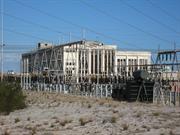
South Fremantle Power Station is a high-volume, steel framed building, representing a late Art Deco industrial design. The external steel frame is clad in concrete rendered and painted with a predominantly vertical window treatment continuous between levels in the recessed bays between columns. Steel window frames throughout are clear glazed.
Construction of South Fremantle Power Station commenced in 1946. The Minister for Electricity, David Brand, officially opened it in June 1951. South Fremantle Power Station worked in conjunction with the East Perth Power Station to supply the Metropolitan area with power. Much of the machinery in the Power Station was designed and manufactured in England. A major fire occurred at the power station in 1954. Though only structural damage occurred, the fire was the catalyst to the change from coal to oil fuel for the station. During the mid-1970s however, South Fremantle Power Station reverted back to coal. In the 1980s extensions to the Muja Power Station, located near the coal supplies at Collie, led to the closure of both the East Perth and South Fremantle Power Stations. As production of electricity had become uneconomical at these sites, East Perth closed in 1981 and South Fremantle in 1985. Since 1994 the Power Station has had its plant and equipment removed and the workshops, amenities building, canteen and ash pump chamber have been transferred or demolished. A part of the contract for readying the building for any future occupancy was the removal of all asbestos materials. Although a number of proposals have been made for the building, including hotel or marine museum, continued deterioration is the only prospect unless a useful tenancy can be achieved.
INTEGRITY: Poor AUTHENTICITY: High
Fair
| Name | Type | Year From | Year To |
|---|---|---|---|
| W.H. Taylor, General Manager of WA Government Electricity Supply | Architect | 1946 | - |
| Ref ID No | Ref Name | Ref Source | Ref Date |
|---|---|---|---|
| HCWA assessment form for "South Fremantle Power Station". | State Heritage Office |
| Owner | Category |
|---|---|
| City of Cockburn | Local Gov't |
| Dep't for Planning & Infrastructure | State Gov't |
This information is provided voluntarily as a public service. The information provided is made available in good faith and is derived from sources believed to be reliable and accurate. However, the information is provided solely on the basis that readers will be responsible for making their own assessment of the matters discussed herein and are advised to verify all relevant representations, statements and information.
The former South Fremantle Power Station Building has cultural heritage significance for the following reasons: the surviving Main Building of the former South Fremantle Power Station, now stripped of all plant, equipment and services, remains aesthetically significant; the building envelope demonstrates- -the strong expression of a structure specifically designed for an industrial process; the internal areas of the cleared building are impressive in the former Boiler House and Turbine Room, where the structural elements are of striking dominance, the vistas through the building are significant and the transparency of the external walls is uncompromisingly apparent in an empty building; the place is a good example of an Industrial structure in the modern international style, being the largest of such structures to be built in Western Australia, and, the building and site housed the first major power generating equipment in the State specifically designed to generate alternating current at the Australian and British Standard Frequency of 50 Hertz. It therefore enabled the initial changeover of the Metropolitan Area Power Supply from 40 Hertz to 50 Hertz operation. Aesthetic Value The main power station building continues to display aesthetic value in the strong external expression of its structural form as a utilitarian industrial building specifically designed to accommodate a process of electric power generation. While the value of natural light was paramount to good design in the use of this building; large expanses of unprotected dear glazing indicated a flawed design, the consequences of which are apparent in the attempts to reduce glare and heat through paint applied to glazing in the western aspect of the building. With the plant and equipment removed, the interiors have a specific aesthetic value due to their proportions and volume of space. The power station by virtue of its size and form in a sparse marine landscape is a prominent building in the immediate vicinity, notwithstanding that loss of the smoke stacks has reduced the potential for high landmark quality. The building remains a prominent element on the shoreline in the coastal sand dunes south of Fremantle; it is clearly visible from the north and south for some distance along the coast and from Owen Anchorage seawards. The recent clearing away of other structures and trees to the north, further exposes the rectilinear bulk of this large off-white building set in a clean but sparse marine environment. Historic Value South Fremantle Power Station influenced development in Western Australia through the formation of the Kwinana Industrial complex and in the Fremantle area through the development of the suburb of Hilton Park. The South Fremantle Power Station was an important step in the development of power generation in the State; as the second largest thermal power station in Western Australia it contributed to the establishment of the interconnected power grid in the South West Power Scheme. South Fremantle Power Station represents a significant technical achievement in the supply of electricity m Western Australia. Scientific Value The technology of South Fremantle power station at 50 cycles generation facilitated the upgrading of power generation in Western Australia and the establishment of the interconnected grid system. Social Value The social value of a major public utility such as a power station and its influence on the whole community should be acknowledged. The involvement of the workforce which designed, built and operated South Fremantle should be acknowledged and respected. Rarit South Fremantle Power Station is one of several power stations built around Australia in the early 1950s, but the only one of its kind in Western Australia, Some of the contemporary building forms survive in the Frequency Changer Building at East Perth, Representativeness One of several power stations built around Australia In the early 1950s, South Fremantle Power Station is typical of its period, of which some are still operational. Condition The main building is structurally sound. The main boiler house and turbine room plant is largely intact and in reasonable condition. But all buildings on site have been vandalised and are in a deteriorated condition. The external structural envelope, internal steel framing and concrete floors appear to be in reasonable condition. Most of the extensive area of glass in the external walls has been smashed by vandals; the original steel framed windows appear to be in reasonable condition although paintwork has deteriorated and there is evidence of corrosion. In some areas of the Administration Control Building, aluminium window frames replace the originai fixed steel frames. There is evidence of corrosion of steelwork and spalling of concrete to some few areas of the external faces of the building and paintwork is damaged and deteriorated. All doors have been vandalised, damaged or removed. A number of major openings have been formed in the east and west walls of the Main Building, for the removal of plant and equipment. The ceramic tiled floor and wall finishes to the Turbine Room are extensively damaged or missing. Bitumastic sealants to all Hat concrete roofs arc now damaged and deteriorated; water intrusion could soon become a threat to the structure if the seals are not replaced. Original metal railings, open mesh floor decking and the few surviving steel service stairways are now in a damaged and corroded condition. The building shell is in reasonable condition and is amendable to. The place is not for public access due to extensive unprotected openings in decking and concrete floors and walls, and unprotected pits, floor channels, basins and tanks, many deep and partly filled with water. The perimeter link mesh fence appears to be in reasonable condition but is not a serious deterrent to unauthorised entry to the site. Integrity The integrity of former South Fremantle Power Station Building has been eroded by the removal of the precipitators and chimney stacks from the roof, the coat tipier and crushing house and the coal conveyor system and all internal plant and equipment. Authenticity What remains of the original buildings is an authentic shell which demonstrates little change in form during the operational life of the power station. The building retains a high degree of authenticity
DESCRIPTION The Former South Fremantle Power Station Building is constructed on coastal dunes on the foreshore of Cockburn Sound. The main power station building is a high volume, industrial building designed specifically for the function of power generation. It comprises the following elements: STATION A BOILER HOUSE A high-volume, steel framed building with the internal steel framing exposed and two main floor levels plus upper intermediary levels of open-meshed steel flooring and interconnecting steel stairways. The concrete flooring on the main levels is ceramic tile finished. The external steel frame is clad in concrete rendered and painted with a predominantly vertical window treatment continuous between levels in the recessed bays between columns. Steel window frames throughout arc clear glazed. A strong system of columns and beams expresses the structural frame of the building on the external face, uncompromisingly indicating high and low volumes throughout the complex. The roof is concrete. Station A formerly housed four 125/150,000 Ib. per hour coal-fired boilers designed and constructed by International Combustion Ltd, London and Derby. Combustion gases were released through two chimneys on the roof of the Boiler House, dust being cleaned by four electro static precipitators also housed on the roof. The precipitators and chimneys and all plant and equipment have now been removed. STATION A TURBINE ROOM An open high volume, two-level steel framed building free of intermediate columns, with a concrete roof supported on a parallel chord steel truss system exposed within the Turbine Room. The external steel frame, as for the Boiler House, is clad in concrete rendered and painted with a predominantly vertical expression of steel-framed windows in the recessed bays between columns. Floors were finished formerly in quarry tiles or open-mesh steel flooring; the walls are finished to dado height in glazed ceramic tiles. Station A housed two Metropolitan Vickers steam turbines powering two 25 MW direct coupling alternators, now completely removed. STATION B BOILER HOUSE AND STATION B TURBINE ROOM - are continuous duplications of Station A and house a repeat of the same plant. The power generating capacity of the power station was 100 MW. The Boiler House runs N-S on the site, along the eastern side of the building and is divided by a full height concrete wall from the Turbine Room which runs the full length of the western face of the Boiler House. An overhead crane remains in place to service the full length of the Turbine Room; this is a product of the Perry Overhead Engineering Crane Co., Adelaide, with a 70 ton load capacity and 10 tons auxiliary. The former turbo alternators and condensing plant, now removed entirely, were designed and produced by Metropolitan Vickers Electrical Export Co. Manchester, together with the 22kV switchgear, 66kV switchgear and main transformers. The 3000V switchgear was designed and constructed by Ferguson Pailin Ltd, Manchester and the 440V switchgear by Australian General Electric Pty Ltd. The condensing plant was designed and constructed by CA Parsons, England and Morts Dock and Engineering Pty, Sydney. All of this plant and equipment has been removed. The main building was designed specified and the construction supervised by the State Electricity Commission of WA. The foundation was designed by the SEC and constructed by the Public Works Department, Steelwork for the main building was designed and constructed by Structural Engineering Co Ltd., Welshpool; and the concrete constructed by W Fairweather & Son, Perth. COAL HANDLING Collie coal was transported to the eastern boundary of the site by railway. Trucks passed through a rotary tippler which emptied coal into a hopper beneath to be elevated by means of a skip to the top of the crushing house where the coal passed over screens to separate small and large coal. Inclined conveyors fed from the crusher across to the Boiler House. Coal was stockpiled in a large yard capable of holding 25,000 tons at a higher level than the Power Station on the eastern side and contained within a concrete perimeter wall. The tippler, crusher house and coal conveyor system have been removed. ASH DISPOSAL At the southern end of the Boiler House, a steel framed Ash Pump Chamber, clad in corrugated asbestos cement sheeting, collected ash carried from the boilers in underground sluice channels and pipework, to be pumped to the southern end of the site to settling pits. The ash disposal plant has been removed. SWITCH HOUSE, CONTROL ROOM, AND TRANSFORMERS These functions were housed in a two-level northern extension of the Power Station, of similar construction, and as part of the same mode of design. All plant and equipment has been removed ADMINISTRATION OFFICES AND LABATORIES The connection between the Turbine Room and the Switch house is a 2/3 level administration building, also of similar construction and design. The main entrance hall is a single high volume chamber housing and impressive if inappropriately grand, surviving terrazzo staircase which rises in a single flight towards the western wall, then divides each Side to the main and intermediary floors. The design of the staircase, balustrading and lighting gixtures are characteristic of the immediate post-war period, reflecting the carry-over of design motifs from the 1930s. WORKSHOPS AND STORES A separate steel framed workshop and store building was formerly located immediately south of the Turbine Room, This was a single-storied industrial building of 5 bays of sawtooth steel trussed roofing clad in corrugated asbestos cement sheeting. The walls and floor of the building were reinforced concrete. The building, formerly in a deteriorated condition due directly to vandalism and lack of maintenance, has been completely removed. AMENITIES BUILDING A separate single stoned timber-framed amenities building with masonry dado was formerly located south of the Boiler House and east of the Workshops The seven-bay building had a hipped roof clad in asbestos cement sheeting. The building formerly in a deteriorated and heavily vandalised condition, has been completely removed. CANTEEN Located south from the Amenities Building, the Canteen was formerly a single stoned timber framed building sheeted externally with weatherboard over a masonry dado. The gable ended Pitched roof is clad in corrugated asbestos cement sheeting. The building formerly heavily vandalised, has been completely removed. The switchyard does not fall within the scope of this assessment. The switchyard is operational. The groynes and water basin are now in a deteriorated and partly silted condition.
Assessment 1998 Construction 1946-51 . HISTORICAL OVERVIEW Records relating to the power station are held at Western Power head office, library and archives, Wellington Street, Perth and at the SECWA Energy Museum in Fremantle. It is possible that records exist in the archive storage building at the East Perth power station site but this resource has not been accessed. Public records include photographs at the Battye Library and the historic photos collection of West Austmlian Newspapers. Drawings for the construction of the building-and its plant have not been discovered No approach has been made to former engineers or workers who operated the power station to record oral history of the place. The history of the power station at South Fremantle is summarised as follows. The history of the establishment of the Western Australian Government Electricity Supply, the degree of standardisation which came with the one supply system for Perth and the adoption of 40 cycle frequency ^ecorded in the Conservation plan for the East Perth Power Station. Work commenced on the construction of die power station at East Perth in 1913, followed by power generation from the first unit in 1916. A number of suburban and country town power stations were in operation for local electricity requirements and continued together with the upgrading of East Perth beyond the commencement of discussion in 1932 concerning the requirement for a power station at South Fremantle. The Royal Commission completed its investigation into a proposed South West Power Scheme in 1940. The proposal was rejected. In 1943 thc Government asked the Electricity Advisory Committee to undertake a further much broader inquiry lnto the Proposal to establish the South West power Scheme, under the chairmanship of Russell Dumas. V.J.F. Brain, chief electrical Engineer of the PWD in NSW was commissioned to advise on the feasibility of converting power supply from 40 to 50 cycles. His report Standardisation of Electricity Supply in Western Australia - 1943 recommended immediate conversion to 50 cycles. The Dumas report was completed in 1945 to be followed by the letting in September 1945 of a contract for the first two 25,000 kW (50 Hertz) power generating units at a new power station at South Fremantle. Construction of the power station at South Fremantle commenced in January 1946. The South Fremantle site was chosen for its relatively close metropolitan population, its proximity to nearby railway facilities for the delivery of coal and the ease with which sea-water could be utilised for the cooling system.1 The four boilers 1,2, 3 & 4 of 'A' Station were fired up in January 1951, the first 2 5MW turbo-alternator came on line in May of that year prior to the official opening of the Power Station on 27 June 1951 by the Hon. David Brand, Minister for Electricity. The opening plaque records W.H Taylor (M1EE MIE. Aust.) as the General Manager of the WA Government Electricity Supply (1914-1946) and General Manager of the Metropolitan Systems of the State Electricity Commission (1946 to 1948). In September 1951, the second 25 MW turbo alternator came on line. When the decision was made to build a new power station at South Fremantle with a greater capacity than that of East Perth Power Station, the question of continuing with 40 cycle frequency came under scrutiny. By the early 1940s 40 Hertz was non-standarcd in Australia as well as overseas. In England and on the east coast of Australia the standard was 50 cycle; in the USA 60 cycles. The cost to convert all existing electrical equipment and appliances to operate on the higher frequency would entail a huge cost beyond the resources of the State. When the Federal Government agreed to contribute to the cost in order to achieve a national standard, the new frequency was adopted with the commissioning of the power station at South Fremantle. A frequency changer unit was installed in a specially constructed building at East Perth to al]ow the two stations to operate in conjunction in supplying the metropolitan area. The new frequency changer building at East Perth was designed in the same mode as the power station at South Fremantle and was constructed simultaneously with South Fremantle and completed in 1951. The conversion of the existing Metropolitan electricity system from 40 to 50 cycles and the task of adapting appliances and equipment was undertaken by the SEC until completion in I960. All metropolitan supplies were generated at the East Perth Power Station until 1951 when the power station at South Fremantle came on load. The No, 3 turbo alternator came on load in -B' Station at South Fremantle in January 1954, and the No 4 turbo alternator in December 1954. The station at South Fremantle was then complete with a total capacity of 100 MW. As much of the plant was designed and manufactured in England, skilled contractors were sent out to South Fremantle from England to assemble the plant on site. Many of these contractors, and their families, stayed in Western Australia and were employed by the State Electricity Commission. Other workers at the Station were ex-goldfields men with first class steam tickets seeking post-war employment. The first SEC men at South Fremantle Power Station were volunteers from the East Perth Station these arrived on site in late 1948 and formed the nucleus of the tradesmen. The SEC encouraged the recruitment of staff by providing housing in the Hilton Park area, and the new suburb soon had many community amenities. A bus service from the Power Station to Hilton and Fremantle provided a welcome service for shift workers. Over 250 workers were employed at South Fremantle during the 1950s, the majority of whom were men. The female minority were employed in the canteen or on the switchboard. The workers were represented by various trade unions and there was generally good trade relations at South Fremantle. Only one strike came directly out of South Fremantle Power Station. This occurred in April 1971 when workers went out over wages. There was excellent camaraderie and a strong term spirit amongst the workers at South Fremantle. A quick game of soccer or water polo at lunch time was not uncommon; others fished or swam. The SEC had the State's first local credit union, which was started at South Fremantle Power Station in 1962. Staffed by volunteers, the credit union provided great assistance for workers in financial trouble. There was also a strong social club and the monthly special events were usually well attended; the Christmas parties were a social highlight. After retirement, many workers continued to meet and socialise at the Hilton Park Bowling Club or at the Point Walter Golf Club. In 1954, a major fire at South Fremantle in the coal conveyor from the crusher house caused structural damage and resulted in a switch to oil fuel for the boilers. A photograph dated 1980 at the Energy Museum shows coal on site at South Fremantle. Conversion back to coal, as happened at East Perth, also occurred at South Fremantle in the mid-1970s and coal then fuelled this station until its closure in 1985. In 1956 the Wellington Dam Hydro-electric Generating Station was commissioned and Collie Power Station interconnected with East Perth and South Fremantle. With the start of the development of the South West Power Scheme, the building of an interconnected power grid became necessary. Due to the high cost of transport of coal from the Collie coalfields to the Metropolitan area, considerable savings could be effected by building the next major power station at Bunbury, where an adequate supply of sea-water was available for cooling. In May 1957, the new Bunbury Power Station commenced operation with one 30 MW turbine and two 15 MW boilers, and the metropolitan and south west power systems were connected in the same year with first of two the Bunbury to Cannington 132 kV lines. Bunbury, Collie, South Fremantle and East Perth power stations were thus linked to form the interconnected grid. The second and third 30 MW units came on line in Bunbury in 1959 and 1960, and the fourth in 1961. Later when an alternative method of cooling became available with considerably reduced requirements of cooling water, the third major power station was built at Muja on the Collie coalfields. The location of this station, alongside the major open-cut coal seam, again greatly reduced the cost of conveying coal from the mine to the face of the station bunkers. The decision to construct Maja power station stage A with two 60 MW coal fired generating units was taken in 1960; the second stage B at Muja was decided in 1963. The first unit came into operation in 1965 with interconnection into the Bunbury grid. The second unit came into operation in 1966 when the Muja Power Station was opened by the Premier David Brand. Mujaunits3 & 4 came into operation in 1968 and 1969. At Kwinana in September 1970, the first 120 MW unit of a new oil-fired power station came on line, prior to the official opening by Sir David Brand in November of that year, and the No. 4 unit m December 1973. In that year, the Power System Control Centre at East Perth Power Station became operational. The No. 5 unit 200 MW turbine at Kwinana Power Station came on line in March 1976, and the No. 6 in April 1978. Conversion of Kwinana to coal commenced in 1978 and was completed in 1979. Each new Power station with its larger machines operating at higher steam pressures and temperatures, together with a reduction of operating and maintenance staff per kilowatt hour generated, resulted in higher generation efficiencies which gradually phased out the operation of the older stations as 'base load stations'. Further extensions to Muja Power Station were completed in 1980 and 1982. Power generation ceased at East Perth December 1981 bringing to an end 65 years of continuous power generation at that station. Further stages at Muja Power station were officially opened in 1985, and in September that year, the South Fremantle Power Station was closed and approximately 70 workers laid off,5 The production of electricity at South Fremantle had become uneconomical. The interconnected grid then was supplied from the power stations with more up-to-date machinery and closer to the coal source at Collie - Bunbury, Kwinana and Muja. South Fremantle Power Station was the second thermal power station to be constructed in the metropolitan area and is to be noted for signalling the beginning of a totally new venture at the time the inter-connected system that functions today in the south west sector of the State. Since August 1994, action on the site has included the documentation, contracting and completion of asbestos removal, the clearing out of all plant and equipment from the entire building and the complete removal of the Workshops and Stores, Amenities Building, Canteen and Ash Pump Chamber and associated structures and services.
This information is provided voluntarily as a public service. The information provided is made available in good faith and is derived from sources believed to be reliable and accurate. However, the information is provided solely on the basis that readers will be responsible for making their own assessment of the matters discussed herein and are advised to verify all relevant representations, statements and information.
Cockburn Rd & Beeliar Dr Coogee & Munster
Lot 2 Mayor Road, Munster. Lot 700 Cockburn Road, Coogee. Lot 48 Cockburn Road, Coogee.
Coogee Lime Kilns
Munster Lime Kiln
Tylee Lime Kiln
Cockburn
Metropolitan
Constructed from 1905, Constructed from 1984
| Type | Status | Date | Documents |
|---|---|---|---|
| Heritage List | Adopted | 14 Jul 2011 | |
| State Register | Registered | 17 Feb 2006 | HCWebsite.Listing+ListingDocument, HCWebsite.Listing+ListingDocument |
| Type | Status | Date | Documents |
|---|---|---|---|
| (no listings) |
| Type | Status | Date | Grading/Management | |
|---|---|---|---|---|
| Category | ||||
| Municipal Inventory | Adopted | 10 Apr 2014 | Category A | |
Coogee lime Kilns are in sound condition. Tylee Lime Kiln is in sound condition. Munster Lime Kiln has elements of sound nd poor condition.
Historic site
| Epoch | General | Specific |
|---|---|---|
| Original Use | MINING | Other |
| Present Use | VACANT\UNUSED | Vacant\Unused |
| Style |
|---|
| Other Style |
| Type | General | Specific |
|---|---|---|
| Wall | STONE | Limestone |
| General | Specific |
|---|---|
| OCCUPATIONS | Mining {incl. mineral processing} |
| DEMOGRAPHIC SETTLEMENT & MOBILITY | Immigration, emigration & refugees |
| OCCUPATIONS | Commercial & service industries |
This information is provided voluntarily as a public service. The information provided is made available in good faith and is derived from sources believed to be reliable and accurate. However, the information is provided solely on the basis that readers will be responsible for making their own assessment of the matters discussed herein and are advised to verify all relevant representations, statements and information.
Constructed from 19015, Constructed from 1984
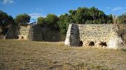
Three Lime Kilns Group is a rare remaining example in the Metropolitan Area of early 20th century lime kilns. Three Lime Kilns Group was instrumental in the economic development of Cockburn. Three Lime Kilns Group is associated with prominent lime merchants Joseph Tylee and Thomas Briggs and R. J. Rowland, and with the men who worked at the kilns, in particular Yugoslav and Italian migrants. Three Lime Kilns Group are good representative examples of their type. Coogee Lime Kilns has a landmark quality in its prominent location at the edge of open, level ground beside Cockburn Road. Three Lime Kilns Group has the archaeological potential to reveal information about the lime burning industry.
Three Lime Kilns consists of Coogee Lime Kilns, Tylee Lime Kiln and Munster Lime Kiln. The Kilns were constructed for the purpose of heating limestone to affect the chemical process for converting limestone into quicklime. The Kilns are utilitarian structures, with the form determined by the requirements of the lime burning process. Coogee Lime Kilns are located near the western edge of Len McTaggart Park, a reserve that runs beside Cockburn Road. The reconstructed Kilns are a two chamber kiln constructed of limestone. Tylee Lime Kiln is around 250 metres to the south of Coogee Lime Kilns. The kiln is concealed within an area of densely planted trees on the eastern edge of the Cockburn Road reserve beside the western edge of Powell Reserve. The structure consists of a single chamber that has been filled with soil. Only the west side of the kiln is visible. The west wall is about 3 m high and is built predominately of limestone. It has a brick base. Munster Lime Kiln is located at the western end of the Munster Wastewater Pumping Station in Beeliar Drive. The structure consists of a single chamber measuring 5 m by 3 m wide and about 3 m high.
The process of burning limestone used in these kilns fired by wood was similar to Roman kilns. Lime kilns in Cockburn were fired with logs up to eight feet in length and blackboys; layers of lime and fuel were carted to a level with the top of the kiln and tipped into the opening which was closed by galvanised iron, as was the small opening below once the kiln was alight. It burnt continuously for 48 hours. Early kilns were constructed on the site of the limestone quarry and timber and blackboys were transported to it by horse and cart. Later, timber was brought by rail to Robbs Jetty siding for the kilns along the old coast road, and lime was transported to the goldfields by rail. Later again, with motor transport, kilns were once again constructed away from the railway line in Spearwood.
INTEGRITY: Unable to be used as kilns AUTHENTICITY: High, although some reconstruction of Coogee Lime Kilns
Medium
| Ref ID No | Ref Name | Ref Source | Ref Date |
|---|---|---|---|
| "National Estates Study". |
| Owner | Category |
|---|---|
| Western Australian Planning Commission | State Gov't |
| Water Corporation of WA | State Gov't |
This information is provided voluntarily as a public service. The information provided is made available in good faith and is derived from sources believed to be reliable and accurate. However, the information is provided solely on the basis that readers will be responsible for making their own assessment of the matters discussed herein and are advised to verify all relevant representations, statements and information.
Lot 9000 Glenister Rd Hamilton Hill
Includes addresses: 17 Glenister Rd, Hamilton Hill; Lot 28 Davilak Ave, Hamilton Hill; Lots 128-129 Janson Rd, Hamilton Hill; Lot 127 Glenister Rd, Hamilton Hill; 83 Hamilton Rd, Spearwood; Lots 10, 61-64 & 2010 Azelia Rd, Spearwood.
Azelia Ley Homestead
Cockburn
Metropolitan
Constructed from 1866 to 1982
| Type | Status | Date | Documents |
|---|---|---|---|
| Heritage List | Adopted | 14 Jul 2011 | |
| State Register | Registered | 22 Jun 2001 | HCWebsite.Listing+ListingDocument, HCWebsite.Listing+ListingDocument |
| Type | Status | Date | Documents |
|---|---|---|---|
| (no listings) |
| Type | Status | Date | Grading/Management | |
|---|---|---|---|---|
| Category | ||||
| Municipal Inventory | Adopted | 10 Apr 2014 | Category A | |
| Classified by the National Trust | Classified | 02 Feb 1982 | ||
| Register of the National Estate | Nominated | 30 Apr 1982 | ||
| Register of the National Estate | Interim | 24 Jun 1997 | ||
The ruins of Davilak Homestead are in poor condition with most walls reduced to 40-60 cm in height and no structural timbers left in situ. However, the archaeological evidence associated with the ruins of Davilak Homestead is undisturbed with a high potential to contain stratified archaeological deposits. The 1850s Manning homestead complex and several outbuildings and field systems which exist as archaeological sites within Manning Estate, Hamilton Hill appear undisturbed with a high potential to contain undisturbed stratified archaeological deposits. Azelia Ley Homestead is in good condition.
| Library Id | Title | Medium | Year Of Publication |
|---|---|---|---|
| 10036 | The changing Cockburn Coast. Appendices - European Heritage | Electronic | 2008 |
| 11358 | Cast iron pillar boxes of Western Australia: An early history of the J & E Ledger foundry | Book | 2015 |
| 9926 | Manning Estate, Hamilton Hill | Heritage Study {Cons'n Plan} | 2011 |
| 1887 | Azelia Ley homestead restoration Report on completion of works Vol1 and photographs vol 2 | Heritage Study {Other} | 1986 |
| 11385 | Archaeological management strategies for Davilak Ruins, Manning Estate, Hamilton Hill | Heritage Study {Other} | 2014 |
Individual Building or Group
| Epoch | General | Specific |
|---|---|---|
| Original Use | FARMING\PASTORAL | Homestead |
| Original Use | FARMING\PASTORAL | Stable |
| Present Use | EDUCATIONAL | Museum |
| Style |
|---|
| Victorian Regency |
| Type | General | Specific |
|---|---|---|
| Wall | STONE | Limestone |
| Roof | TILE | Ceramic Tile |
| General | Specific |
|---|---|
| DEMOGRAPHIC SETTLEMENT & MOBILITY | Settlements |
| SOCIAL & CIVIC ACTIVITIES | Cultural activities |
| OCCUPATIONS | Grazing, pastoralism & dairying |
| PEOPLE | Early settlers |
| DEMOGRAPHIC SETTLEMENT & MOBILITY | Land allocation & subdivision |
This information is provided voluntarily as a public service. The information provided is made available in good faith and is derived from sources believed to be reliable and accurate. However, the information is provided solely on the basis that readers will be responsible for making their own assessment of the matters discussed herein and are advised to verify all relevant representations, statements and information.
The building has touches of two period styles. Features such as Georgian steps, front door and internal fireplaces are applied to enhance the appearance in a late Victorian era. The early local Georgian primitive stone and brickwork is not in sympathy with the main structure. The main historic value is in the building within a setting rich in history of early pioneers. The owners wish to restore and use the building to house artefacts donated from the district. Note: the Museum was opened in 1983
The homestead was built on the west side of Lake Manning for Azelia Helena Manning in approx. 1905 when she married. She ran it as a farm homestead. The construction of the house is in two distinct styles. The rear section which appears to be the first built, is in two distinct styles. The rear section which appears to be the first built, is of local limestone with red brick quoins at corners and around openings. This construction is consistent with the associated farm buildings i.e. Sulky Shed and Stables. The main house is of solid brick construction with outside walls plastered, shingle roof (now covered with Marseilles tiles). A formal lawn setting braces the eastern side with two large Queen palms and a Norfolk Pine. The house has had minor internal changes to accommodate being rented I more recent years. The reserve, part of the original Manning estate, consists of adjacent park and lake and caretakers cottage has been built nearby. There is also evidence of a well behind the homestead.
Assessment 1982
This information is provided voluntarily as a public service. The information provided is made available in good faith and is derived from sources believed to be reliable and accurate. However, the information is provided solely on the basis that readers will be responsible for making their own assessment of the matters discussed herein and are advised to verify all relevant representations, statements and information.
Constructed from 1920
10184 Manning Park
Azelia Ley Homestead is part of an uncommon and intact example of a precinct of farm buildings in the Metropolitan Region. Azelia Ley Homestead has a long association with the Manning family, and with Azelia Ley (née Manning) in particular, for whom the homestead was built. Azelia Ley Homestead is a well proportioned example of a home in the Victorian Regency style. Azelia Ley Homestead is representative of early settlement and development in the Cockburn district. Azelia Ley Homestead has aesthetic value as part of a precinct of farm buildings of uniform construction and style.
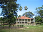
Azelia Ley Homestead comprises the main homestead residence (c.1920) and associated outbuildings, located in Manning Park. The main body of the residence, which is almost square in plan, has a small kitchen wing attached to the south side of the building. The residence has broken-back verandahs against the east, north and west faces. It has a Marseilles profile terracotta tiled gambrel roof. Apart from a small area of the north side of the building, where the walls are of uncoursed rubble with brick quoins, the external walls have a rendered finish that has been decorated with ashlar lining. The main façade of the building is composed around a centrally located recessed bay with slightly projecting bays placed on either side. The central bay contains the front door and glazed sidelights. Each of the projecting bays contains three timber framed double hung sash windows. Outbuildings include a single-roomed limestone building, stables, ‘Old Wagon House’, two freestanding toilets and a water tank.
Manning Park is named after a prominent Cockburn resident, Lucius Manning. The Manning family developed a large estate with two homes around a lake formerly known as Davilak (and now known as Manning). The Aboriginal name for the water was Dgilgie’s Lake which was changed to Devil’s Lake by Manning, and subsequently pronounced Davilak by local Aborigines. There is archaeological evidence of the first Manning homestead constructed on the site (c.1850s), which is located to the north of the lake. Davilak House and surrounding complex of outbuildings was built by convict labour around 1866. The building and its outbuildings were abandoned after 1946 and burnt down in the late 1950s. The house constructed by Manning for his daughter, Azelia Ley, remains as a museum for the Cockburn district. Vegetation around Manning Lake consists of swamp paper bark and some large tuart trees, which are now rare in Cockburn. The lake is utilised for recreation and leisure pursuits, with the banks cleared and some landscaping around the trees. Children’s play equipment attracts families to the setting.
INTEGRITY: Moderate: the residence and outbuildings now serve a compatible use as a museum AUTHENTICITY: Moderate: main elements of the residence are intact, but there is uncertainty regarding the changes made during restoration works. Original shingle roof replaced with tile.
Good
| Ref ID No | Ref Name | Ref Source | Ref Date |
|---|---|---|---|
| G Nayton; "Conservation Plan for Davilak Ruins". | |||
| HCWA assessment for Azelia Ley Homestead | State Heritage Office |
| Owner | Category |
|---|---|
| City of Cockburn | Local Gov't |
This information is provided voluntarily as a public service. The information provided is made available in good faith and is derived from sources believed to be reliable and accurate. However, the information is provided solely on the basis that readers will be responsible for making their own assessment of the matters discussed herein and are advised to verify all relevant representations, statements and information.
1 Rockingham Rd Hamilton Hill
Cnr Cockburn Rd. Lot 3.
Cockburn
Metropolitan
Constructed from 1912
| Type | Status | Date | Documents |
|---|---|---|---|
| Heritage List | Adopted | 21 Jul 2011 | |
| State Register | Registered | 07 Sep 2006 | HCWebsite.Listing+ListingDocument, HCWebsite.Listing+ListingDocument |
| Type | Status | Date | Documents |
|---|---|---|---|
| (no listings) |
| Type | Status | Date | Grading/Management | |
|---|---|---|---|---|
| Category | ||||
| Statewide Hotel Survey | Completed | 01 Nov 1997 | ||
| Municipal Inventory | Adopted | 10 Apr 2014 | Category A | |
Fair to good condition
| Name | Type | Year From | Year To |
|---|---|---|---|
| Christian Frederick Mouritzen - unconfirmed | Architect | - | - |
| Library Id | Title | Medium | Year Of Publication |
|---|---|---|---|
| 10036 | The changing Cockburn Coast. Appendices - European Heritage | Electronic | 2008 |
| 8913 | The Newmarket Hotel. Rockingham Road, Hamilton Hill. Photographic record. | Heritage Study {Other} | 2008 |
Individual Building or Group
| Epoch | General | Specific |
|---|---|---|
| Original Use | COMMERCIAL | Hotel, Tavern or Inn |
| Present Use | COMMERCIAL | Hotel, Tavern or Inn |
| Style |
|---|
| Federation Filigree |
| Type | General | Specific |
|---|---|---|
| Wall | STONE | Limestone |
| Roof | ASBESTOS | Fibrous Cement, corrugated |
| Wall | BRICK | Pointed Brick |
| General | Specific |
|---|---|
| SOCIAL & CIVIC ACTIVITIES | Sport, recreation & entertainment |
| OCCUPATIONS | Hospitality industry & tourism |
This information is provided voluntarily as a public service. The information provided is made available in good faith and is derived from sources believed to be reliable and accurate. However, the information is provided solely on the basis that readers will be responsible for making their own assessment of the matters discussed herein and are advised to verify all relevant representations, statements and information.
Constructed from 1912
Newmarket Hotel is a landmark as an imposing two-storey building located on a prominent corner site and featuring a distinctive parapeted form that is truncated at the corner. Newmarket Hotel is associated with the horse racing industry – which thrived in the area from the early 1900s to the 1970s – as a consequence of being near South Beach Horse Exercise Area. Newmarket Hotel is associated with the expansion of industry and agriculture south of Fremantle from the late nineteenth century, in particular the horse racing industry which thrived in the area from the 1900s to the 1970s. Newmarket Hotel was run from 1945 to 1949 by George Russell Thompson, a professional boxer from 1922 to 1930 who was the Australian heavyweight boxing champion.
Newmarket Hotel is a two-storey building situated on a very busy intersection. The Hotel is built from coursed rough faced limestone. The walls also feature brick quoins and the roof is screened by a parapet wall. A verandah at the top storey level extends along three sides of the building. The original verandah had timber posts, balustrades and lattice work which were removed at some stage. The verandah has a separate corrugated iron roof and now has metal supporting posts. It represents one of many two-storey corner pubs built in Western Australia around the turn of the century.
Newmarket Hotel was the second hotel built in the area and it is the only one to continue operating under the original licence. From the early days until the 1960s there was a drinking trough for horses on the western side of the hotel, on the eastern side of Cockburn Road. In early times market gardeners from South Coogee and Spearwood and stockmen from Robbs Jetty and the Anchorage frequented the hotel. They would stop and water their horses and refresh themselves. Racehorse owners and trainers were among the many customers of the Newmarket. The hotel was a starting place for many bicycle races which were popular before the advent of the motor car. In November 2008, it was announced that the hotel was to be restored to its former glory by Fremantle lawyer, Paul Maston.
INTEGRITY: High AUTHENTICITY: High: changes to external fabric include painting of the brick quoining and rendered ashlar effect to the limestone on the street elevation. Timber posts, valance and balustrading to verandah have been replaced with metal. The section at the southern end of Cockburn Street appears to be a later addition.
Fair to good
| Ref ID No | Ref Name | Ref Source | Ref Date |
|---|---|---|---|
| National Trust WA Assessment Documentation | National Trust WA | ||
| HCWA assessment for Newmarket Hotel | State Heritage Office |
This information is provided voluntarily as a public service. The information provided is made available in good faith and is derived from sources believed to be reliable and accurate. However, the information is provided solely on the basis that readers will be responsible for making their own assessment of the matters discussed herein and are advised to verify all relevant representations, statements and information.
24 Rockingham Rd Hamilton Hill
Cnr Hardey St Includes: dwelling, stables, laundry & well plus landscape and mixed trees
Cockburn
Metropolitan
Constructed from 1923 to 1924
| Type | Status | Date | Documents |
|---|---|---|---|
| Heritage List | Adopted | 14 Jul 2011 | |
| State Register | Registered | 14 May 2002 | HCWebsite.Listing+ListingDocument, HCWebsite.Listing+ListingDocument |
| Type | Status | Date | Documents |
|---|---|---|---|
| (no listings) |
| Type | Status | Date | Grading/Management | |
|---|---|---|---|---|
| Category | ||||
| Classified by the National Trust | Classified | 10 Sep 2001 | ||
| Municipal Inventory | Adopted | 10 Apr 2014 | Category A | |
| Library Id | Title | Medium | Year Of Publication |
|---|---|---|---|
| 10036 | The changing Cockburn Coast. Appendices - European Heritage | Electronic | 2008 |
| 5590 | Randwick Stables, Hamilton Hill : conservation plan. | Heritage Study {Cons'n Plan} | 2002 |
Individual Building or Group
| Epoch | General | Specific |
|---|---|---|
| Original Use | FARMING\PASTORAL | Stable |
| Present Use | FARMING\PASTORAL | Stable |
| Style |
|---|
| Federation Bungalow |
| Type | General | Specific |
|---|---|---|
| Wall | METAL | Other Metal |
| Wall | TIMBER | Weatherboard |
| Wall | ASBESTOS | Fibrous Cement, flat |
| Wall | STONE | Limestone |
| Wall | ASBESTOS | Other Asbestos |
| General | Specific |
|---|---|
| SOCIAL & CIVIC ACTIVITIES | Sport, recreation & entertainment |
| DEMOGRAPHIC SETTLEMENT & MOBILITY | Land allocation & subdivision |
This information is provided voluntarily as a public service. The information provided is made available in good faith and is derived from sources believed to be reliable and accurate. However, the information is provided solely on the basis that readers will be responsible for making their own assessment of the matters discussed herein and are advised to verify all relevant representations, statements and information.
Constructed from 1923
Randwick Stables has strong streetscape value and landmark qualities. The built elements have rustic charm and the interior of the house is of particular aesthetic interest. The cottage and stables represents the large number of registered stables that operated in the Cockburn region in the first half of the 20th century when the area played an integral role in the development of the state’s horse racing industry. The place is a fine and rare remaining example of small stables in an urban environment. Randwick Stables is associated with local South Fremantle racing identities and trainers Frederic ‘Jack’ Marks, Sol Marks and Jimmy Banks.
Randwick Stables comprises a series of paddocks, a timber framed cottage, stables, laundry, water closet. Two palms flank the front entrance, and the house is timber framed, clad with weatherboards. The main roof is hipped, corrugated iron, with a rear lean-to with a skillion roof. Verandahs enclose three sides of the house. The verandah has a bull nosed roof and is supported by stop chamfered posts. The whole verandah is infilled with lattice. The stables located at the rear of the property are based on an L-shaped plan.
Randwick Stables comprises a series of paddocks, a timber framed bungalow, stables, laundry stone well, water closet and metal clad stables constructed for Frederick Charles John ‘Jack’ Marks, a member of the prominent horse racing Marks family. At the turn of the century South Fremantle and the northern parts of Cockburn like Hamilton Hill became the location of semi rural industries such as market gardening and horse racing stables. In the early 1900s Lot 4 of Cockburn Sound Location 5 was subdivided and lots 23,24 and 27 were transferred to ‘Jack’ Marks in 1924. Horse racing played an integral role in the development of South Fremantle and Hamilton Hill with the first horse races in the Swan River Colony held at South Beach on 3 October 1833. Horse stables were a characteristic feature in residential areas located near South Beach. At the height of the horse racing industry it is believed 400 horses were stabled in the area and trained at South Beach. Thus trainers and jockeys such as the Marks family became well known identities. Jack and Amy Marks went to live in Kalgoorlie in 1917. Jack was joining his three brothers Bill, Sol and Percy who were already involved in horse racing on the Eastern Goldfields of WA. Jack and Amy lived in Kalgoorlie until they moved to South Fremantle with their three children. Family history has it that as Jack was unable to sell his house at Cheetham Street, Kalgoorlie, he dismantled the timber house and transported it by train to his newly purchased property in Rockingham Road. After the four roomed cottage was reconstructed a verandah was added on three sides of the building. A wash house was erected and a well dug to the north-west of the main house. Like his brothers Jack began to work in South Fremantle as a horse trainer. To this end an L-shaped stable was constructed to the rear of the main house. Of limestone random rubble construction, the stable comprised six horse stalls and a jockey and tack room, which was tin lined with wooden floor boards. On 1 April 1926 Jack Marks died and ownership of the property was transferred to his wife Amy and then subsequently to his brother Sol Marks. Sol did not appear to take up residence at the property but continued to operate the stable. In 1927-28 the property and business was registered as Randwick Stables. Randwick Stables was sold to John Egan of West Perth who was registered as its owner on 15 April 1930. From then until 1939 the Collett family occupied the property. Joseph Collett was a trainer associated with the trotting industry. Egan moved into the house at Randwick Stables in 1939 but did not train horses full time. He kept a couple of horses and rented out stalls to trainers in the area. In 1950-51 Mrs Florance Mary Banks is recorded as the owner of Randwick Stables. Her husband Jimmy Banks trained Beau Vasse from the stables and this horse won the 1950 Perth Cup. It is believed the winnings of the Perth Cup were used to purchase the stables, although Mary Banks is not officially registered as the owner of the property until 1960. Mrs Banks in her history of Randwick Stables recalled that ‘some good horses were stabled there’. James Ronald Banks and Merilyn Banks were registered as the owners of Lot 25 a portion of the Randwick Stables property in 1964. According to Main Roads WA the transfer was a wedding gift for James Banks. Further land was transferred in 1969 leaving the Randwick Stables property comprising of Lots 23,24,26 and 27 this continues to be the case in 2002. Physical evidence shows that renovation work was carried out to the main house c. 1950-60s. In 1999 the banks sold Randwick stables to the Main Roads WA. The purchase of the property by Main Roads was part of a scheme for a road highway network.
INTEGRITY: High AUTHENTICITY: High
Fair to good
| Ref ID No | Ref Name | Ref Source | Ref Date |
|---|---|---|---|
| HCWA assessment documentation for Randwick Stables | State Heritage Office |
| Owner | Category |
|---|---|
| Main Roads WA | State Gov't |
This information is provided voluntarily as a public service. The information provided is made available in good faith and is derived from sources believed to be reliable and accurate. However, the information is provided solely on the basis that readers will be responsible for making their own assessment of the matters discussed herein and are advised to verify all relevant representations, statements and information.
The house provides a landmark due its position close to the road, near the crown of a hill, and because of its distinctive surrounding latticework. It is a rare example of the Australian Vernacular style in the city of Cockburn. The house and stables represent links to the early horse racing history or Western Australia and remains the only operating training stable in the area. The house, stables washhouse and well all remain in near original condition and the house is rare in its history or transportation from Kalgoorlie by rail. The site is valued by the community both as a landmark, and as a place where people visit to pet the horses.
Assessment 2001 Construction 1923 Alterations/additions 1935- 41 Builder: Frederick Charles John "Jack" Mack
This information is provided voluntarily as a public service. The information provided is made available in good faith and is derived from sources believed to be reliable and accurate. However, the information is provided solely on the basis that readers will be responsible for making their own assessment of the matters discussed herein and are advised to verify all relevant representations, statements and information.
South Beach Hamilton Hill
Cockburn
Metropolitan
Constructed from 2001
| Type | Status | Date | Documents |
|---|---|---|---|
| (no listings) |
| Type | Status | Date | Documents |
|---|---|---|---|
| (no listings) |
| Type | Status | Date | Grading/Management | |
|---|---|---|---|---|
| Category | ||||
| Municipal Inventory | Adopted | 10 Apr 2014 | Category C | |
16120 South Beach Horse Exercise Area
Historic site
| Epoch | General | Specific |
|---|---|---|
| Present Use | COMMERCIAL | Bank |
| Original Use | MONUMENT\CEMETERY | Monument |
| Style |
|---|
| Other Style |
| Type | General | Specific |
|---|---|---|
| Other | METAL | Bronze |
| General | Specific |
|---|---|
| PEOPLE | Local heroes & battlers |
This information is provided voluntarily as a public service. The information provided is made available in good faith and is derived from sources believed to be reliable and accurate. However, the information is provided solely on the basis that readers will be responsible for making their own assessment of the matters discussed herein and are advised to verify all relevant representations, statements and information.
Constructed from 2001
C. Y. O’Connor Statue, commemorating his suicide at South Beach, has aesthetic, historic, representative, social and rarity cultural heritage significance. The bronze statue is a moving, fine and rare example of public art that is an important reminder of O’Connor’s tragic last moments. C. Y. O’Connor Statue is associated with C. Y. O’Connor, who made a significant contribution to engineering in Western Australia. C. Y. O’Connor Statue is associated with the long-standing practice of horse training in Cockburn.
A bronze statue, depicting a man on a horse, in the ocean approximately 30 metres from the beach.
The memorial to C. Y. O’Connor off shore at South Beach is a monument to an influential personality in Western Australia’s history. O’Connor was closely associated with South Beach as he often rode his horse along this stretch of beach. O’Connor was appointed Engineer-in-Chief of Western Australia becoming leader and initiator of a large government works program. O’Connor’s biographer indicated that the economic stability of Western Australia in the 1890s when the Eastern States suffered a recession, was partly owing to ‘the appointment of O’Connor as Engineer-In-Chief and his insistence that the principles of efficiency and economy be observed’. O’Connor was known for two major projects in Western Australia the Fremantle Harbour and the Mundaring to Kalgoorlie water pipeline. The harbour at Fremantle was an important project to Western Australia as the absence of safe anchorages had led to Fremantle becoming a secondary port to Albany. After long discussions, O’Connor’s plan of removing the rock bar from the mouth of the Swan River and constructing wharves along the river banks was adopted. Work commenced in 1892 and continued until 1900 when the first steamer entered and berthed at the new port. The second major engineering feat of O’Connor saw the construction of a reservoir at Mundaring in the hills outside Perth and a pipeline to the goldfields through which water was pumped at a number of stations. On 10 March 1902 O’Connor, aged 59, tragically rode his horse into the water off South Beach and shot himself. The monument to O’Connor was sculpted by Tony Jones and put in place at an unveiling ceremony in 2001. About 30 descendents of O’Connor gathered at the unveiling of the bronze statue. The location of the statue recognises not just the scene of his suicide but his close association with the horse training that still occurs on South Beach in 2002. At the time of the unveiling a temporary plaque was placed on the beach however, owing to its fragility it has since been washed away. A number of people have requested that interpretative material for this monument be placed nearby to benefit the many visitors to the beach.
INTEGRITY: High AUTHENTICITY: High
Good
| Name | Type | Year From | Year To |
|---|---|---|---|
| Tony Jones | Architect | 2001 | - |
| Ref ID No | Ref Name | Ref Source | Ref Date |
|---|---|---|---|
| J Banks; "South Beach: A Personal History". | 2001 | ||
| Information supplied in a proposal to HCWA to nominate South Beach to the State Register of Heritage Places, prepared by Alison Bolas | 2002 | ||
| Correspondence between Lorna M. Frame and City of Cockburn and City of Fremantle | July-August 2001 | ||
| M Tauman; "The Chief CY O'Connor". | West Australian | 19/6/1999 | |
| CT Stannage (ed); "A New History of Western Australia". | UWA Press | 1981 |
This information is provided voluntarily as a public service. The information provided is made available in good faith and is derived from sources believed to be reliable and accurate. However, the information is provided solely on the basis that readers will be responsible for making their own assessment of the matters discussed herein and are advised to verify all relevant representations, statements and information.
Cockburn Rd Henderson
Naval Base Caravan Park
Naval Base Shacks
Cockburn
Metropolitan
Constructed from 1933
| Type | Status | Date | Documents |
|---|---|---|---|
| Heritage Area | Adopted | 14 Jun 2012 |
| Type | Status | Date | Documents |
|---|---|---|---|
| RHP - To be assessed | Current | 30 Nov 2012 |
| Type | Status | Date | Grading/Management | |
|---|---|---|---|---|
| Category | ||||
| Municipal Inventory | Adopted | 14 Jun 2017 | Category B | |
17868 Peel Town Archaeological Sites
| Library Id | Title | Medium | Year Of Publication |
|---|
Individual Building or Group
| Epoch | General | Specific |
|---|---|---|
| Present Use | COMMERCIAL | Other |
| Original Use | SOCIAL\RECREATIONAL | Other |
| General | Specific |
|---|---|
| SOCIAL & CIVIC ACTIVITIES | Sport, recreation & entertainment |
This information is provided voluntarily as a public service. The information provided is made available in good faith and is derived from sources believed to be reliable and accurate. However, the information is provided solely on the basis that readers will be responsible for making their own assessment of the matters discussed herein and are advised to verify all relevant representations, statements and information.
The Naval Base Shacks have cultural heritage significance for the following reasons: • The place is representative of Western Australian coastal shack settlements that developed as holiday destinations from the 1930s to 1960s and demonstrates a way of life during that time as well as the evolution of the site since then. • The place is one of eleven remaining shack settlements in Western Australia and the only shack settlement located within the Perth metropolitan area. • The place is highly valued by the community and has been used as a holiday destination since the late 1930s, with ownership of shacks being passed down through generations of families. • The place has overall uniformity in scale, however each shack has an individual character which has developed over time and collectively they form a distinctive cultural landscape and vernacular style. • The place has the potential to yield archaeological deposits and provide a greater understanding of Clarence, Thomas Peel’s 1830s settlement. • The place has the potential to contain archaeological deposits that relate to the residence erected by Thomas Peel in 1830. Aesthetic The place contributes to the natural environment of Cockburn Sound, providing residential character in a coastal area that is surrounded by heavy industry. (C1.3) The distinctive vernacular style of the settlement contributes to the character and landscape quality of the area. (C1.4) Historic The place is associated with the evolution of the concept of ‘the seaside holiday’. This began in the early 1900s by booking into a hotel by the sea and developed into one where more people took holidays as they built their own accommodation (shacks) in a popular seaside location that was not located near the popular metropolitan beaches. (C2.1) The place displays the gradual formalisation of a ‘shack settlement’. These settlements began with an ad hoc collection of structures (caravans with annexes and simple constructed shacks) to one where rules were developed to formalise the size, appearance and design of the shacks. (C2.2) The place is associated with the training of military personnel, including the 10th Light Horse Regiment, prior to the outbreak of World War II. (C2.2) Scientific The place has the potential to contain archaeological deposits related to Thomas Peel’s failed 1830 settlement, Clarence. These deposits have the potential to yield information on how the settlers first tried to establish a foothold in an unfamiliar environment, the types of objects they brought with them and then later abandoned as this frontier environment became too difficult to endure. (C3.1) This place may contain archaeological deposits associated with the house erected by Thomas Peel at this Clarence settlement. (C3.2) Social The place is highly valued by the community and the generations of families that have used the site as a holiday destination since the late 1930s. (C4.1) The place has high social value for the shack community, with shacks being passed down through generations. (C4.2) Rarity The place is one of eleven remaining shack settlements in Western Australia and the only shack settlement located within the Perth metropolitan area. (C5.1) The place demonstrates a way of life from the 1950s and 1960s and how holiday destinations promoted an outdoor lifestyle not seen as frequently today. (C5.2) Representativeness The place is representative of coastal shack settlements developed as holiday destinations from the 1930s to the 1960s in Western Australia. (C6.2) Integrity Currently the place has a high level of integrity, however care should be taken to ensure future development and regulation does not extinguish the character of the site. Authenticity While the place only contains a few of the original caravan and annexe shacks, those constructed from the 1960s remain mostly unchanged, with the exception of modern additions such as gas bottles and solar panels.
is bounded to the west by cliffs adjoining the Indian Ocean and Challenger Beach, to the east by Cockburn Road and to the south by Sutton Road. The surrounding area is a mix of heavy industrial and natural reserves with Beeliar Regional Park to the east, the Australian Marine Complex to the north and the Kwinana Industrial area to the south. There are three entrances to the site, two from Cockburn Road, which are situated either side of the ablution blocks and one from Sutton Road at the south boundary of the site. The site covers an area of 45468m2(26), which includes 178 shacks, which are arranged in five rows running north-south. The site predominately consists of mown grassed areas with an internal bituminised road system looping between the rows of shacks. Vegetation on the site is limited with the exception of a few mature, established trees adjoining some of the shacks including weeping mulberry (Morus pendula), bougainvillea sp. and Agave americana. In addition to the layout, the size and scale of the shacks contributes to the overall uniformity of the site. While the original shacks consisted of caravans with attached permanent annexes, there are only a few of this type in existence today, such as that shown in Figure 22. The majority of shacks are in the size limit of 5.2m x 5.2m and constructed of varying materials including brick (Figure 25), timber framed building clad with weatherboards both painted (Figure 23) and unpainted (Figure 24), corrugated iron (Figure 20) and fibrous cement sheeting, painted in bright colours (Figures 18 and 19). A number of the timber framed shacks are also clad with weatherboards to the lower half of the structure and the upper clad with fibrous cement sheeting (Figure 21). All of the shacks have low pitched gable roofs clad with corrugated galvanised iron. While the shacks are similar in form, they have been personalised using colour, the use of name boards and being adorned with personal belongings as well as plantings and furniture which gives each shack a different appearance. All shacks are orientated to the west and there is an unwritten rule that extensions can only be on the east or west sides so as not to block other residents’ views. Some of the shacks that directly face the ocean, are constructed on raised brick or limestone block foundations as shown in Figure 21. As no mains electricity, water or gas is permitted at the site, many shacks have solar panels or small wind turbines installed as well as external gas bottles. There are public taps located within the site with potable water. There are two (male and female) brick and tile ablution facilities on the site as well as a brick and tile laundry block, supplied and constructed by the City of Cockburn for use by the residents.
Assessment 2019 Construction 1930s, 1950s, 1060s The area surrounding the Cockburn Sound has been continually occupied by the Beeliar Nyungar Aboriginal people for over 40,000 years. Beeliar Nyungars are a clan of the Whadjuk Nyungar group, whose land covers the Perth Metropolitan area. Beeliar Nyungar means river people and the area now bounded by the City of Cockburn holds a high level of significance for the group due to its high prevalence of wet lands and water courses. While the main areas of significance are situated around the Bibra and North Lake areas, there are two registered Aboriginal sites in the locality of Henderson, Lake Coogee and a site on Cockburn Road. While there are no sites of significance located within Reserve 24308, the area around Cockburn Sound was integral to the cultural practices of the Beeliar Nyungar Aboriginals being an important source of resources and is respected as such today. The first European settlement to the area was in the December 1829 when Thomas Peel arrived on the Gilmore. Peel had entered into an agreement with the British Colonial Office for a grant of land between the Swan and Canning Rivers if he arrived before November 1829. However the passage from England was delayed and Peel was instead granted 250,000 acres of land around Cockburn Sound. The settlement named Clarence, was conceptualised in England and based on very little knowledge of Australian conditions. As such the settlement struggled from inception, with settlers being unfamiliar with the sandy land and finding it difficult to establish crops. The harsh conditions combined with the lack of supplies led to the settlement being abandoned within two years of establishment. While initially there was some indecision as to where the settlement of Clarence was located, in early 2007 the site, was discovered by Notre Dame University archaeologists and further excavation located the site on Reserve 39584 and Reserve 39752, which are directly adjacent to the site of the Naval Base Shacks. In February 2008 the Heritage Council issued a Conservation Order for the area named Peel Town Archaeological Sites, to avoid confusion with the later Clarence Town settlement located near Woodman Point. The extent of the registration was then updated in 2014 (Figure 5) to include the site of the shacks as well as identifying zones of archaeological potential within the site, particularly Thomas Peel’s 1830s residence (Figure 6). Due to the complexity of the site and ongoing research there is a high potential for archaeological remains in Reserve 24308, the site of the shacks. Despite the early failure of the Clarence settlement, from 1870 to 1890 there was a steady growth in industry and market gardens around the Cockburn Sound area. This was further expanded during the Gold Boom which saw the development of lime kilns and meat works in the area.8 In 1910, British Admiral Sir Reginald Henderson recommended that a naval base be built in Cockburn Sound, however construction was delayed due to the outbreak of World War I and the venture was eventually abandoned in the 1920s. Prior to the outbreak of World War II, the beaches extending from Cockburn Sound to Woodman Point were utilised for military purposes, including the 10th Light Horse Regiment, which undertook tactical exercises on Challenger Beach. Despite being used as a camp throughout the 1940s, the development of the naval base was never recommenced and by the 1960s the current Garden Island location was allocated for this purpose. During the late 1930s and early 1940s the first shacks began to appear on the site. At this time there were only a few shacks, which consisted of caravans with temporary annexes that were constructed on an ad hoc basis. In 1955 they were described as “little clusters of weekenders’ shacks” and from aerial photography taken in 1955 (Figure 12) and 1965 (Figure 13) it is clear that it was not until the 1960s that the site began to grow and by 1965, outlines of rows of orderly shacks can be seen, which is not dissimilar to the current layout. Following World War II and into the 1960s the nearby Kwinana industrial area expanded exponentially and the high demand for import and export facilities led to the construction of large industrial shipping areas along the north eastern foreshore of Cockburn Sound. In light of the increasing pressure on the land a number of reserves were created to protect the natural environment and community interests. In October 1955, Reserve 24308 was created for the purposes of public utility and in July 1957 the reserve was vested to the Cockburn Road Board in trust for the purpose of recreation and camping. The vesting order was then transferred to the Shire of Cockburn in 1961 and is now held by the City of Cockburn. Coinciding with the management of the site by the Cockburn Road Board in the late 1950s, permanent shacks began to be constructed on the site, with the shack owners leasing the area from the Cockburn Road Board for a small fee. While the size of shacks was limited to 5.2m x 5.2m they could be constructed of any material and as such were often made from recycled corrugated iron and metal struts salvaged from other buildings. In addition to recycled materials, cheap and freely available supplies such as fibrous cement sheeting were also used. The shacks soon became a popular and affordable family holiday destination for residents in the Cockburn region as well as the wider Perth metropolitan area. The outdoor and uncomplicated nature of the shack settlement led to the creation of a strong community atmosphere and generations of families continue to enjoy swimming, fishing, snorkelling, diving, boating and barbequing at the site. In June 1968 the site was impacted by a severe storm which tore through the caravans and shacks destroying forty caravans and damaging twenty four shacks, requiring extensive repair and causing many to be demolished and reconstructed. During the 1990s, the future of the shacks was threatened by industrial expansion as well as the broader issue of coastal development. Due to the uncertainly of the site, owners were prohibited from buying or selling shacks until 2000 when the expansion of port facilities in Cockburn Sound was suspended. From 2000 the embargo on buying and selling was lifted and between 2000 and 2001 owners sold their shacks privately with prices ranging from $5,000 to $18,000. While other shack settlements in Western Australia faced demolition under the 1989 Squatter Policy, the Naval Base Shacks were not subjected to the same level of regulation as even though there were regular holiday makers at the site prior to the creation of the reserve in 1955, these dwellings mainly consisted of caravans with ad hoc annexes, and permanent shacks were only constructed on the site after 1955, when it was under the management of the Cockburn Road Board. Following the introduction of the Land Administration Act 1997, vesting orders were converted into management orders and in May 2009, the City of Cockburn entered into an agreement for twenty one years with the power to lease. In 2004 the City of Cockburn added the site to the Municipal Inventory at a category B level and in 2009 undertook a heritage assessment of the site. However it was not until 2012 that the heritage status of the site was formally recognised. In 2010 the City of Cockburn considered reducing the category status of the site to C, this decision resulted in an outcry by the community and the National Trust advocated for the site to be listed as category A and included in the Town Planning Scheme. In order to determine the appropriate future management of the site, the City of Cockburn established a Community Reference Group, which enabled shack owners to present their views. Also at this time the Environment and Public Affairs Committee were conducting an inquiry into the shack sites in Western Australia that was released in April 2011. The inquiry found that the shacks differed from other shack sites in Western Australia as not only were they located in the metropolitan area but that the site was carefully maintained in a uniform manner and encouraged continued community consultation in deciding the outcome.19 As a result of community perseverance, in 2012 the City of Cockburn endorsed five year leases at a fee of $2,000 per year20 and a management plan was developed for the site. The designation of the site as a Heritage Area under the Local Planning Policy 4.5, also saw the development of accompanying policy and guidance documentation including an updated lease agreement, buying and selling transfer processes, standard development conditions and the requirement of permits for development or demolition of shacks. Under the policy shack owners are only permitted to occupy the shacks for 120 days per year and the use of generators or the installation of showers or toilets are prohibited. In 2017 the City of Cockburn agreed to renew leases at the site for another five years.22 This provided a level of certainty and protection for shack owners as prior to 2012, leases were only issued annually and could be cancelled at the discretion of the City of Cockburn at any time with 14 days’ notice.23 The shacks are highly valued by the owners and for the last fifty years the Naval Base Shacks Association has acted as not only a conduit between the shack owners and the City of Cockburn in the management of the site, but also to actively encourage the continuation of the strong community spirit. The Association facilitates the shack community’s events and traditions, including Easter celebrations, annual children’s fun days and Christmas events.24 These events not only demonstrate the level of social cohesion at the site but also contribute to the community’s sense of place. The Naval Base Shacks have been used by generations of families as a holiday destination since the late 1930s. The establishment of the site as a reserve and the subsequent management by the City of Cockburn enabled families to build permanent dwellings which have an overall uniformity in size and scale but are distinguishable by the level of personalisation and continued use. Each shack has an individual character which has been developed over time and collectively the shacks form a distinctive cultural landscape. While the evolution of the shacks is listed as a distinguishing feature in the City of Cockburn’s Heritage Area documentation,25 there is concern that strict planning controls and increased uniformity will negatively influence the character of the site and the distinctive vernacular style which is key to the heritage value of the shacks. The Naval Base Holiday Association approached the National Trust in 2018 to undertake a heritage assessment for the purposes of including the place in the National Trust’s Classification list and further strengthen recognition of the heritage values of the place.
This information is provided voluntarily as a public service. The information provided is made available in good faith and is derived from sources believed to be reliable and accurate. However, the information is provided solely on the basis that readers will be responsible for making their own assessment of the matters discussed herein and are advised to verify all relevant representations, statements and information.
Constructed from 1933, Constructed from 1950
Naval Base Holiday Park has been a holiday destination since 1933, and has been used by generations of families from Cockburn and the wider area. It has exceptional social historical value as a popular and well used holiday destination. Naval Base Holiday Park is a good example of holiday camps which used to exist along the Western Australian coastline but have disappeared in the face of development. As a holiday destination the overall site has a high degree of authenticity. Although the condition of individual shacks varies, as a whole the shacks at Naval Base Holiday Park have a uniformity of scale that creates a unique landscape, and gives the place significant aesthetic appeal, especially when combined with the coastal setting. Individual shacks within the Heritage Area have changed over time. The design and construction of the shacks demonstrates the resourcefulness, versatility and creativity of the shack builders and their occupants. The evolution of the shacks is considered to be one of the distinguishing characteristics of the Heritage Area, and it is acknowledged that individual shacks and overall site plan will continue to evolve over time. However, it is considered important that this occurs in a manner that does not adversely impact on the heritage significance of the Heritage Area. For this reason it is not considered that there is any distinction in the level of contribution made by individual shacks to the heritage significance of the Heritage Area. Rather, it is considered that the following overall characteristics of the Heritage Area are essential to conserving its heritage significance: 1) The ongoing use of the site as a holiday destination; 2) General uniformity of scale of the shacks; 3) Modest scale and simple informal ‘holiday shack’ character of the structures; 4) General uniformity of siting and spacing between the shacks, noting that the future spacing will have to meet other regulatory requirements.
Naval Base Holiday Park is a Heritage Area of 178 shacks settled on the mainland, along Cockburn Road in Henderson. It has been a holiday destination since 1933, and used by generations of families from Cockburn and the wider area. Set along limestone cliffs, the site is adjacent to Challenger Beach opposite Garden Island. There are five rows of campsites and 178 holiday shacks. Most of the shacks are a conglomeration of assorted building fabric (often recycled from other buildings), and vary in their condition. The original shacks comprise a caravan with a permanent walled annexe extension. There is little to no vegetation on the site but the shacks are often surrounded by manicured lawns. Overall, there is a uniformity of scale, with many of the shacks being within the original size limit of 16’ x 17’ (approx 5.2m x 5.2m). Although individual shacks have changed since 1933, as a holiday destination the overall site has a high level of integrity and authenticity.
The site now occupied by Naval Base Holiday Park is associated with the attempts at settlement by Thomas Peel in 1829. Consequently, it is possible that there are archaeological remains at the site which may warrant investigation at a future time. Naval Base Holiday Park has a continuous history as a holiday destination since c.1933. The original Caravan Park extended towards Kwinana, partially situated where heavy industry now exists, and was a weekend retreat for urban residents. When the southern element of the Park was privatised during the 1950s, rising costs resulted in more intensive use of the current site. Unlike other similar sites in Western Australia, the occupiers of shacks at Naval Base Holiday Park are not squatters. The place has been subject to the control of local government since the Park’s inception in 1933, although it is unusual to have lease agreements on a camping reserve. The original ‘holiday homes’ comprised a caravan with a walled annexe, although in at least one case a bus was utilised. A rule in the early days of the camp was that all homes had to have wheels. Subsequently, permanent shacks have been built, in theory with a maximum sized building of 16’ x 17’. An ‘unwritten rule’ states that extensions must only be to the east or west so as not to block views to the ocean. The shacks have no internal running water and no externally supplied electricity. Residents cook and power refrigerators with gas, use solar panels for electrical power and get their water from nearby community taps. Two large ablution blocks are available for the residents. Swimming, snorkelling and fishing are popular activities, and the attraction of the Park is shown by the extended families that have a long association with the site. Oral history interviews with three residents demonstrated an attachment to the recreational lifestyle they and their families have experienced over the decades.
It is possible that there are archaeological remains at the site.
INTEGRITY: High AUTHENTICITY: High
Good
| Ref ID No | Ref Name | Ref Source | Ref Date |
|---|---|---|---|
| C Day & E Fuery; "Interview with John Nelson & Sue Rutland". | 4/5/2001 | ||
| C Day & E Fuery; "Interview with Mick Nicholides". | 4/5/2001 | ||
| Newspaper clipping and magazine reports from 1994-2001, courtesy Barry Doubikin | |||
| "Weekend Courier Rockingham-Kwinana News" | 24/7/1998 | ||
| "The Bulletin". | 25/1/1994 | ||
| "Cockburn Herald". | 1997-2001 | ||
| C Day & E Fuery; "Interview with Barry Doubkin". | 4/5/2001 | ||
| "Cockburn Gazette". | 1997-2001 | ||
| "Weekend Courier Rockingham-Kwinana News". | 16/4/1999 |
| Owner | Category |
|---|---|
| City of Cockburn | Local Gov't |
| Department of Regional Development and Lands - | State Gov't |
This information is provided voluntarily as a public service. The information provided is made available in good faith and is derived from sources believed to be reliable and accurate. However, the information is provided solely on the basis that readers will be responsible for making their own assessment of the matters discussed herein and are advised to verify all relevant representations, statements and information.
Near Mount Brown, Beeliar Regional Park Henderson
Site of 1829-30 Clarence settlment, not to be confused with later Clarence town which is further north near Woodman Point.
Cockburn
Metropolitan
Constructed from 1829 to 1830
| Type | Status | Date | Documents |
|---|---|---|---|
| Heritage List | Adopted | 14 Jul 2011 | |
| s.79 Permit - Archaeological Excavation | YES | 19 Apr 2023 | |
| State Register | Registered | 08 Dec 2022 | HCWebsite.Listing+ListingDocument, HCWebsite.Listing+ListingDocument |
| Type | Status | Date | Documents |
|---|---|---|---|
| (no listings) |
| Type | Status | Date | Grading/Management | |
|---|---|---|---|---|
| Category | ||||
| Municipal Inventory | Adopted | 10 Apr 2014 | Category A | |
| Classified by the National Trust | Adopted | 01 Jan 2012 | ||
| Library Id | Title | Medium | Year Of Publication |
|---|---|---|---|
| 9424 | The enigma of Clarence: Woodman Point or Mount Brown? | Journal article | 2008 |
| 9812 | The land 'flow[ing]... with milk and honey': Cultural landscape changes at Peel town, Western Australia, 1829 - 1830 | Electronic | 2010 |
Historic Site
| Epoch | General | Specific |
|---|---|---|
| Original Use | RESIDENTIAL | Other |
| Present Use | PARK\RESERVE | Park\Reserve |
| General | Specific |
|---|---|
| DEMOGRAPHIC SETTLEMENT & MOBILITY | Settlements |
| PEOPLE | Early settlers |
This information is provided voluntarily as a public service. The information provided is made available in good faith and is derived from sources believed to be reliable and accurate. However, the information is provided solely on the basis that readers will be responsible for making their own assessment of the matters discussed herein and are advised to verify all relevant representations, statements and information.
(A) Clarence Cemetery has historical significance because it was the burial ground for Thomas Peel’s unsuccessful settlement at Clarence in 1830. The fate of those buried there demonstrates how harsh conditions were in the Swan River Colony for European settles in 1830. The site may have significance as an archaeological site, because nothing remains on the ground surface to indicate where the burials were situated or how many there were. Historical importance is because of the very early establishment of the burial ground when the area was first surveyed. It is probably the first cemetery or one of the first in the colony. Social importance is that of all burial grounds for their respective communities The site has both recreational and tourist importance because of its situation on high ground overlooking the coastal scenery. The history of the site demonstrates the harsh way of life and the harsh environment in the days of early settlement. When reading of the families buried there (refer: “a Colony detailed” by Ian Berryman and “Lonely Graves of Western Australia” by Yvonne & Kevin Coate) one begins to understand the development of cultural phases of the settles in the new Swan River Colony (B) Aesthetic Value The site has little aesthetic value due to the very low relief archaeological remains and moderately dense vegetation cover. Historic Value Thomas Peel’s 1830 Site is a fossilised camp dating to 1830 that shows how Western Australia’s earliest settlers adapted to a new environment. With the possible exception of the yet unsurveyed Garden Island 1829 site, it is the best well preserved early settlement camp in Western Australia. Scientific Value Thomas Peel’s 1830 Site has high scientific value. The camp’s archaeology preserve the behaviour patterns of Western Australia’s first settlers, informing about possible maladaptation and the speed of adaptation to the unknown Western Australia physical and cultural environment. The archaeological assemblage can also show whether settlers were prepared for the rigors of settlement, and what they considered their part would be in the Swan River Colony. Social Value Thomas Peel’s 1830 Site has high social value. When occupied in 1830, the camp contained about 33% of Western Australia’s population. Many of Western Australia’s present population have links with the site and the people who lived and died there. Members of the Parker, Edwards, Spice, Tuckey, Thomas, Leeder, Heard, Devenish and Meares families contribute greatly to Western Australia to this day. Rarity Thomas Peel’s 1830 Site is exceptionally rare at regional, national and international levels. Condition Thomas Peel’s 1830 Site is in excellent condition. Authenticity Thomas Peel’s 1830 Site has a very high degree of authenticity
(A) Old Historic Plan 142 (Thomas Peel’s grant near Clarence by George Smythe 1830) shows the burial ground for Clarence. Mr Ian Elliott (Dept of Land and Administration) has plotted this site onto a more recent map, which shows the site as being off Pettit Road Naval Base. Nothing now remains on the ground surface to indicate where the Clarence Cemetery could have been. As the area mapped covers a limestone outcrop, it is difficult to imagine how the graves were dug or where they might have been situated. (B) Thomas Peel’s 1830 Site is in the Beeliar Regional Park in the suburbs of Henderson and Naval Base. The 40.5-hectare area of banksia lowland and exotic vegetation contains the structural remains and discarded items of 500 men, women and children belonging to the Peel Association under the control of Thomas Peel. The material dates to 1830. Two, 15 by 15 metre areas have been examined archaeologically at the time of writing. Designated Site 1 and Site 2, the two areas contain a large collection of material remains. Accessioning of material is yet to begin, but an abridged list of the two sites’ material remains is presented below. Site 1. Site 1’s excavations unearthed a 2 by 4 metre tent pad of local limestone cobbles mortared with lime (Figure 1). A limestone and yellow brick hearth is attached to the pad’s south west corner (Figure 2). The hearth’s brick base is in two levels separated by iron sheeting. Flat limestone at each end of the hearth’s firebox suggests that bread baking also occurred in the feature. The remains of a tent pole and three cast iron tent pegs exist on the pad’s margins, while window glass was unearthed along the pad’s eastern margin. Bottle glass, the remains of an iron ash rake and a complete saltglazed stoneware blacking bottle were found on the pad and in the hearth. Extensive excavations to the pad’s north found a large collection of material. Most of this material was very small, suggestive of artefact deposition caused by sweeping material off the pad. Site 2. Site 2 comprised three areas in a 10 by 15 metre area. Area 1 consisted of partial dry stone limestone wall foundations measuring 2 by 4.5 metres (Figure 3). Excavations exposing the foundations also unearthed a layer of limestone mason’s chips, fragments of glass and ceramics and an 1827-penny. Area 2 of Site 2 has been interpreted as a structure for sleeping and living (Figure 4). A limestone and yellow brick hearth forms most of a probable timber and canvas structure’s south wall, with copper-alloy metal and timber battens used as anchors for the no longer preserved canvas. The structure’s length is 5.5 metres, but width was indeterminable. The archaeological assemblage collected from near Site 1’s limestone pad comprises beads; buttons; brass clothing hooks and eyes; two brass weights stamped with King George III’s mark; window glass – some distorted by melting; copper rod; percussion caps; gun flints; clay smoking pipe fragments and lead shot of various diameters. The lead shot, gunflints and percussion caps were unearthed within a 1 by 1 metre area. A trench about 10 metres long and 10 metres behind the pad contained items discarded by the tent’s occupants. About 1000 artefacts were recovered, including broken black glass bottle fragments; ceramic fragments of underglaze transferware (all blue in colour); creamware and yellowware bowls; a yellowware jug, many nails; an ivory domino piece; a silver chain; a brass 1820 shilling pierced with an iron nail; fragments of pig bone; barrel hoops; clay smoking pipe fragments, and brass pins. An area 32 metres square was excavated around Site 2’s structure. The following is an incomplete list of some artefacts found: five coins (two 1827 pennies, an 1827 shilling, an 1805 Irish penny and a very worn 178? penny); 32 brass thimbles, most for children’s use; c.300 brass pins; many brass clothing hooks and eyes; many brass buttons; a pair of tailor’s scissors; two iron keys; many English flint fragments; pieces of sulphur; tin container fragments; shot; seven gunflints; many clay smoking pipe fragments and glass and ceramic fragments. The fragments of English flint and sulphur are most likely associated with fire making, while the tin container fragments are probably the remains of tinderboxes. The coins were unearthed from a 1.5 by 1 metre area. Area 3 of Site 2 was the site’s cooking area. It comprises a limestone and yellow brick oven (Figure 5) measuring 3 by 1.5 metres. The excavation of heavy deposits of ash and charcoal near the oven’s throat found many nails, fragments of copper metal and pieces of glass and ceramic (some heat affected). Two sites have been excavated to completion at the time of writing. However, above surface features like low mounds of limestone and light artefact scatters at Sites 1 and 2 are also present at five other areas, strongly suggesting that well-preserved structural remains from 1830 exist nearby. In addition, artefacts with 1820 stylistic characteristics are present in small quantities over the 40-hectare area (see Site Plan 11).
Assessment A: 1990 (Cemetery Site) Assessment B: 2008 (Peel's 1830 site) (A) The burial ground off Pettit Road is a relic of Thomas Peel’s failed settlement at Clarence. The scheme suffered from bad luck and bad management. It is believed that about thirty people are buried there, all of whom died within six months of the establishment of the Clarence settlement on 1 January 1830. Most fell victim to scurvy or dysentery. The scheme was unlucky from the start, poorly provisioned and poorly led. The Clarence townsite was abandoned by 1831. Thomas peel went on to Mandurah with some of his remaining settlers and enjoyed better success. (B) Between late 1829 and early 1830, three ships containing about 500 men, women and children arrived off Western Australia’s south west coast. As part of the Peel Association lead by Thomas Peel, the settlers found land promised them in the newly established Swan River Colony already allocated to other settlers. While Peel and colony officials made arrangements regarding the allocation of new land, Peel’s group camped in sand hills fronting Cockburn Sound. There they struggled. Some were confined by indentured servant regulations inhibiting unregulated movement, while others tried making the most of what was available. All had nowhere to go. Descriptions of the camp depict individuals and family groups camped in tents, horse’s boxes and rough timber structures. Poor water, food shortages and summer heat killed 37 people already physically stressed after a four-month voyage from England. Eventually, after new land found for settlers proved poor, the group disbanded, joining other Swan River Colony settlers at Perth, Fremantle and Guildford and the Swan Valley’s agricultural allotments. By 1832, only five people remained at the camp. The camp’s dead were buried in a rectangular area marked on an 1830 map. In 1828, Thomas Peel, cousin of the Home Secretary and later British Prime Minister Robert Peel, entered into a partnership with prominent merchant Solomon Levey to establish a large scale settlement in the proposed Swan River Colony. They planned investing a large sum in the transportation of goods, equipment, livestock and labour to the Swan River Colony in return for grants of land in proportion of one acre for every one shilling sixpence expended. A 250,000-acre grant between the Swan and Canning Rivers was asked for and approved by the Colonial Office. However, to qualify for the grant, many immigrants and considerable capital assets had to arrive in the Swan River Colony by 1 November 1829. Due to delays, the first of Peel’s three ships, the Gilmore with 166 passengers, arrived six weeks late on 15 December 1829. The colony’s Lieutenant governor, James Stirling had, however, by this time granted all of Peel’s 250,000 acres to other settlers. The limited amount of fertile land on the Swan Coastal Plain, and the steady arrival of settlers since June 1829 who wanted land, forced Stirling to enforce the forfeiting clause. Peel’s late arrival meant he and his group had no privileges in the Swan River Colony, but Stirling made concessions by allowing him to select 250,000 acres from Cockburn Sound south to an inlet (Peel Inlet) and along the banks of the rivers flowing into it (the Serpentine and Murray Rivers). With nowhere to go until the making of new land allocation arrangements, the Gilmore’s passengers camped in sand hills near Mt Brown. On 12 February 1830, the Association’s second ship, the Hooghly with 176 passengers of mostly tradesmen and their families, arrived. Shortly after (14 May 1830), the Rockingham with 152 passengers arrived and then ran aground. Descriptions of the Peel town camp conditions are few but poignant. Captain George Bayly, the Hooghly’s second officer, described soon after arriving in February 1830 that most of the Gilmore’s settlers ‘get drunk everyday and lie about in the sun, so that several have been laid up with the fever’. There were many complaints by settlers to Bayly about Peel and his Association, the lack of fresh water, but the availability of too much alcohol. Bayly also mentioned that most of the Hooghly’s recently alighted passengers had congregated in their own area of Peel town that he and other settlers called Hooghly town. Bayly also describes sections of the camp: The cottages were built in a line on each side of a broad road which had been marked out by the surveyor and their fires for cooking were made in the middle of the road. Two or three carpenters and a Ship sailmarker had built themselves comfortable residences, but none of them seemed to think they were going to stay long in the place, as they found there was not much chance of employment...[t]hen I walked up to Hooghly town…a great many women and children were ill… Bayly describes an assortment of structures at Peel town, ranging from horse and cow crates converted for human use (Thomas Peel himself occupied one), houses of unspecified material covered with tarpaulins or thatched with rushes and prefabricated timber structures brought from Britain. The Dunnage family, who arrived on the Gilmore, had a ‘very pretty cottage’, most likely the ‘house in frame’ worth £248 13 shillings fourpence recorded on Dunnage’s list of imported goods. However, most settlers lived in tents and marquees ‘made by Mr Edgington of Tooley Street [London]’. Bayly produced the only visual depiction of Peel town, showing variously sized dwellings laid out with little organization on the windward side of the limestone ridge and extending to the beach and limestone cliffs. It is unclear who did the survey Bayly mentions. Roe, in the Survey Office’s monthly report, records surveying ‘Clarence’ from 25 to 31 January, but George Smythe and Henry Sutherland all produced maps dated to that year containing information about the camp’s location and site of some of its structures. Sutherland’s concentration on the coastline meant the noting of camp items only near the beach and rocky coast (like Peel’s house and store), but Smythe’s survey proceeded further in land. His map clearly shows a wide track passing between two small hills with small dwellings flanking the track and Peel’s house at the water’s edge. He records nine dwellings of unknown building material and no tents, while the graveyard and the well near Watson’s dwelling appear a later addition. By June 1830, Peel Association members were strung along the coast at Peel town, Mangles Bay (some of the people from the Rockingham that had moved from Peel’s Scheme) and near the Murray River where a small group of men assessed land. Due to continued misfortune and accident, Thomas Peel was recuperating on HMS Sulphur moored in Gage Roads, leaving Peel town’s settlers without command or advice. People’s health by this time had deteriorated further from what Bayly described. General illnesses like ophthalmia and stomach ailments were common in the Swan River Colony at this time, but the concentration of people at the camp result in greater severity. In Peel’s absence, complaints and concerns about the camp were sent to Stirling, and the resulting investigation saw the Sulphur’s surgeon, Alexander Collie, visit the site. Collie’s report examined settlers’ health, quantity and quality of food and water and the camp’s living conditions. He found about 400 people, many suffering scurvy and dysentery. He also recorded the deaths of 29 settlers, most due to dysentery and scurvy (14 and five respectively), but fatalities also due to pneumonia, childbirth complications (that claimed mother and child) and a child having died of convulsions after drinking a large quantity of alcohol. Two stillbirths are included in the 29, but not George McKenzie’s fatal spearing by Aboriginal people. Food issued from the camp’s store was sufficient but of varying quality and unavailable for the very sick, while good water had been difficult to procure until the coming of heavy rain. Collie visited the settlers’ huts, particularly those in which death had occurred, finding them ‘with a few exceptions, tolerably water proof and well ventilated, although small’. A small hospital covered with canvas existed. Collie considered that poor food and water caused much of the sickness, but ‘irregular habits’ of some of the camp’s men contributed to their deaths. He recommended growing vegetables immediately to counter scurvy. Collie found the health of the small groups at Mangles Bay and Murray River good, with the later group growing antiscorbutic plants. By August 1830, 37 of Peel town’s members were dead. Collie’s report showed Stirling that Peel was not supplying the camp’s members adequate supplies as required by indentured contracts. Despite complaints from Peel, Stirling in August 1830 released 12 families from their indentureships, and shortly after more received permission to leave. Many moved to Fremantle, Perth, Guildford and the Swan Valley, while others remained with Peel when he moved to Peel Inlet (Mandurah). By 1832, only five people remained at Peel town.
This information is provided voluntarily as a public service. The information provided is made available in good faith and is derived from sources believed to be reliable and accurate. However, the information is provided solely on the basis that readers will be responsible for making their own assessment of the matters discussed herein and are advised to verify all relevant representations, statements and information.
Constructed from 1829, Constructed from 1830
The site of early European settlement has remained undisturbed due to its bush location. It is highly valuable as it has not been built over, when comparable sites in Perth have been. Peel Town Archaeological Sites has the potential to reveal information on the colonisation of new places, the effects on the environment by a new group, adaptation to new physical and cultural 295 | P a g e environments, and understanding the mindset of an emigrating group. Peel Town Archaeological Sites is rare as a place associated with the first phases of colonisation.
Archaeological site near Mount Brown, within Beeliar Regional Park. Claimed to feature remains of the abandoned Clarence settlement of 1829-30, now called Peel Town to avoid confusion with the later and larger Clarence Town which is further north near Woodman Point. Artefacts include four collapsed limestone structures, five artefact scatters and numerous individual artefacts. Artefacts are of ceramics, glass, metal and clay. Includes a tent pad with tent pegs and pole. Clarence was one of the earliest European settlements in Perth, it was abandoned after two years. A new settlement of the same name was established further north from 1836.
Thomas Peel proposed that a township to be known as Clarence be established at Woodman Point. Early maps show the Clarence Town site occupying the area between Cockburn Sound and Lake Coogee. Peel brought 490 settlers with him from England on the Gilmore in order to establish his new colony. Owing to a series of disasters and mistiming the settlement was abandoned within three years, leaving approximately sixty graves behind. However, there is some dispute as to where exactly Western Australia’s earliest arrivals established Clarence Town in 1829. For many years it was believed the site was at Woodman Point, about 10km south of the port city. However, Notre Dame archaeologist Dr Shane Burke claims the archaeological evidence shows Clarence was at Mt Brown, about 8km south of Woodman Point. Dr Burke has unearthed many artefacts, from bottles and coins to limestone structures believed to be part of settlers’ homes. The site also contains a gravesite with what Dr Burke claims are the remains of settlers, mostly women and children, who succumbed to the harsh and isolated conditions. However, historians Pamela Statham Drew and Ruth Marchant James disagree with Dr Burke, and state that Clarence was at Woodman Point and the area Dr Burke excavated was a small settlement made by people moving away from the initial camp in 1830.
Peel Town Archaeological Sites is rare as a place associated with the first phases of colonisation.
INTEGRITY: Site only AUTHENTICITY: Site only
Site Only
| Ref ID No | Ref Name | Ref Source | Ref Date |
|---|---|---|---|
| HCWA Database No. 17868 | State Heritage Office | ||
| Register National Estate | |||
| National Trust Australia (WA) Documentation | National Trust WA |
| Owner | Category |
|---|---|
| City of Cockburn | Local Gov't |
| Alcoa of Australia Ltd | Other Private |
| Dep't for Planning & Infrastructure | State Gov't |
| Conservation Commission of Western Australia | State Gov't |
| Town of Kwinana | Local Gov't |
| Industrial Lands Development Authority | State Gov't |
This information is provided voluntarily as a public service. The information provided is made available in good faith and is derived from sources believed to be reliable and accurate. However, the information is provided solely on the basis that readers will be responsible for making their own assessment of the matters discussed herein and are advised to verify all relevant representations, statements and information.
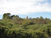
Cockburn Rd Munster
Channel Marker & Trigonometric Beacon, Munster
Cockburn
Metropolitan
Constructed from 1872, Constructed from 1874
| Type | Status | Date | Documents |
|---|---|---|---|
| Heritage List | Adopted | 14 Jul 2011 | |
| State Register | Registered | 03 Jun 2005 | HCWebsite.Listing+ListingDocument, HCWebsite.Listing+ListingDocument |
| Type | Status | Date | Documents |
|---|---|---|---|
| (no listings) |
| Type | Status | Date | Grading/Management | |
|---|---|---|---|---|
| Category | ||||
| Municipal Inventory | Adopted | 10 Apr 2014 | Category A | |
Channel Marker and Trigonometric Beacon, Munster is in good condition. There are some areas of inappropriate render repairs and isolated small areas around its base where the limestone has lost its render.
Historic site
| Epoch | General | Specific |
|---|---|---|
| Original Use | Transport\Communications | Water: Other |
| Present Use | VACANT\UNUSED | Vacant\Unused |
| Style |
|---|
| Other Style |
| Type | General | Specific |
|---|---|---|
| Other | STONE | Limestone |
| General | Specific |
|---|---|
| TRANSPORT & COMMUNICATIONS | River & sea transport |
| OUTSIDE INFLUENCES | Water, power, major t'port routes |
This information is provided voluntarily as a public service. The information provided is made available in good faith and is derived from sources believed to be reliable and accurate. However, the information is provided solely on the basis that readers will be responsible for making their own assessment of the matters discussed herein and are advised to verify all relevant representations, statements and information.
Constructed from 1874, Constructed from 1872
Channel Marker Obelisk is a rare remaining example of a limestone obelisk navigational marker along the coast of Western Australia, and demonstrates the principal characteristics of a Victorian seamark and trig point. Channel Marker Obelisk is associated with the 1870s hydrographic survey of Gage Roads and Cockburn Sound, which sought to find a safe passage and anchorage to gain access to Fremantle by P & O Mail Steamers. It functioned as a seamark for entry to Cockburn Sound through the Challenger Passage and is important in the history of navigation in Western Australia. Channel Marker Obelisk is a simple, unadorned man made object with landmark qualities, conspicuously sited on a ridge within a rugged natural bush setting. Channel Marker Obelisk combines with Woodman Point Lighthouse as a pair of significant navigational elements, which occupy a prominent location.
Channel Marker Obelisk is a rendered limestone rubble obelisk located above Jervoise Bay in Cockburn Sound. It was constructed between 1872 and 1874 as a trig point for the hydrographic survey of Gage Roads and Cockburn Sound, and was subsequently used as a seamark for the Challenger Passage into Cockburn Sound between Carnac and Garden islands. Channel Marker Obelisk is located at 32° 09’ south and 115° 46’ east.
Between 1872 and 1874, a detailed survey of Cockburn Sound and Gage Roads was undertaken by Staff Commander Archdeacon and Staff Commander J. E. Coghlan of the Royal Navy. Channel Marker Obelisk was constructed as a trig point for the survey. It may have been constructed with convict labour, although no record of this has been found. The survey of the Challenger Passage showed that a vessel with a 16’ draught was the greatest that could be taken through the channel safely. The P & O Steamers had a draught of 18’. Another passage known as the North Channel, which was nearer to Garden Island, had deeper water, but there were several limestone pinnacles which made that passage particularly dangerous. Following these surveys, regulations prohibited vessels of over 16’ draught from passing through the Challenger Passage.
INTEGRITY; High: the place continues to fulfil the function of a navigational marker and could at any time fulfil the function of a trig point if required AUTHENTICITY: High: the place, including its setting, appears to be unchanged
Good: there are some areas of inappropriate render repairs and isolated small areas around its base where the limestone has lost its render
| Ref ID No | Ref Name | Ref Source | Ref Date |
|---|---|---|---|
| HCWA assessment for ; "Channel Marker & Trigonometric Beacon, Munster". | State Heritage Office |
| Owner | Category |
|---|---|
| Fremantle Harbour Trust Commissioners | State Gov't |
This information is provided voluntarily as a public service. The information provided is made available in good faith and is derived from sources believed to be reliable and accurate. However, the information is provided solely on the basis that readers will be responsible for making their own assessment of the matters discussed herein and are advised to verify all relevant representations, statements and information.
Cockburn Rd Munster
Reserve 24061
Cockburn
Metropolitan
| Type | Status | Date | Documents |
|---|---|---|---|
| Heritage List | Adopted | 14 Jul 2011 |
| Type | Status | Date | Documents |
|---|---|---|---|
| (no listings) |
| Type | Status | Date | Grading/Management | |
|---|---|---|---|---|
| Category | ||||
| Municipal Inventory | Adopted | 10 Apr 2014 | Category A | |
00508 Woodman Point Lighthouse and Keepers' Cottages
Individual Building or Group
| Epoch | General | Specific |
|---|---|---|
| Present Use | RESIDENTIAL | Single storey residence |
| Original Use | Transport\Communications | Water: Housing or Quarters |
| Style |
|---|
| Federation Bungalow |
| Type | General | Specific |
|---|---|---|
| Roof | METAL | Corrugated Iron |
| Wall | STONE | Limestone |
| General | Specific |
|---|---|
| TRANSPORT & COMMUNICATIONS | River & sea transport |
This information is provided voluntarily as a public service. The information provided is made available in good faith and is derived from sources believed to be reliable and accurate. However, the information is provided solely on the basis that readers will be responsible for making their own assessment of the matters discussed herein and are advised to verify all relevant representations, statements and information.
Constructed from 1902
Lighthouse Keepers’ Houses are fine examples of the Federation Bungalow style. Lighthouse Keepers’ Houses are associated with Woodman Point Lighthouse, which has played an important role in the development of shipping and transport services for the region since its construction in 1902.
Lighthouse Keepers’ Houses are located downhill from Woodman Point Lighthouse. Set close to Cockburn Road, they are now almost in a suburbanised setting. Built on the same design, these houses are good examples of the Federation Bunglaow architectural style. The houses are symmetrical in design with central steps leading onto the verandah. The verandah borders three sides of the house and there are decorative dual chimneys. The Houses are made of locally quarried limestone. The exterior walls are constructed from random laid limestone blocks, and the hipped roof is made from corrugated iron.
Lighthouse Keepers’ Houses are associated with Woodman Point Lighthouse. When first opened, the Lighthouse was a significant point of reference for local shipping. The lighthouse needed to be well maintained to service the sea traffic. The keepers carried out this function. The first keepers were Mr Hutchinson and Mr Arthur Dray. In 2009, the houses are private residences.
INTEGRITY: High AUTHENTICITY: High
Very Good
| Ref ID No | Ref Name | Ref Source | Ref Date |
|---|---|---|---|
| HCWA Place No. 00508 | State Heritage Office | ||
| National Estate Study |
| Owner | Category |
|---|---|
| Department of Regional Development and Lands - | State Gov't |
| Fremantle Port Authority | State Gov't |
This information is provided voluntarily as a public service. The information provided is made available in good faith and is derived from sources believed to be reliable and accurate. However, the information is provided solely on the basis that readers will be responsible for making their own assessment of the matters discussed herein and are advised to verify all relevant representations, statements and information.
Cockburn Rd Munster
Registered as part of P508 Woodmans Point Lighthouse and Lighthouse Keepers' Cottages.
Cockburn
Metropolitan
| Type | Status | Date | Documents |
|---|---|---|---|
| (no listings) |
| Type | Status | Date | Documents |
|---|---|---|---|
| (no listings) |
| Type | Status | Date | Grading/Management | |
|---|---|---|---|---|
| Category | ||||
| Municipal Inventory | Adopted | Category A | ||
00508 Woodman Point Lighthouse and Keepers' Cottages
Individual Building or Group
| Epoch | General | Specific |
|---|---|---|
| Present Use | Transport\Communications | Water: Lighthouse |
| Original Use | Transport\Communications | Water: Lighthouse |
| Type | General | Specific |
|---|---|---|
| METAL | Steel | |
| Other | GLASS | Glass |
| Wall | STONE | Limestone |
| General | Specific |
|---|---|
| TRANSPORT & COMMUNICATIONS | River & sea transport |
This information is provided voluntarily as a public service. The information provided is made available in good faith and is derived from sources believed to be reliable and accurate. However, the information is provided solely on the basis that readers will be responsible for making their own assessment of the matters discussed herein and are advised to verify all relevant representations, statements and information.
Constructed from 1902
Woodman Point Lighthouse has played an important role in the development of shipping and transport services for the region. Woodman Point Lighthouse has been in constant operation since its construction. Woodman Point Lighthouse has significant landmark value. Woodman Point Lighthouse is constructed from locally quarried limestone, creating a strong aesthetic relationship with the surrounding environment. Woodman Point Lighthouse is a representative example of a turn of the 20th century limestone lighthouse.
Woodman Point Lighthouse is a 32 foot high limestone lighthouse, with two associated residences. The lighthouse was the first built in Cockburn and has been in constant operation since its construction. It stands on a limestone hill on the east side of Cockburn Road, slightly north of east in relation to Woodman Point. The structure is cylindrical in shape and made of local stone. It has platforms extending outside the line of the stonework with a guard railing all around. The platform is surmounted by a glass dome housing the lights mechanism. The lighthouse is the only one in Australia with the red and green light sectors reversed, the result of incorrect installation.
Woodman Point Lighthouse has been a prominent and significant landmark within the boundary of the City of Cockburn since it was built in 1902. It was the first lighthouse built within the area. The first lighthouse keepers were Mr Hutchinson and Mr Arthur Dray. They lived at the base of the lighthouse in two cottages built as their residences. The last lighthouse keepers before automation were L. McBride and L. Livesey. As far as can be ascertained it has functioned non-stop since construction and has never been extinguished, even during World War II. Today it is a popular subject for photography and artists and has become a focal point for visitors.
INTEGRITY: High AUTHENTICITY: Light added pointing southwest
Very Good
| Name | Type | Year From | Year To |
|---|---|---|---|
| Chance Bros & Co Ltd, Birmingham, England | Architect | 1902 | - |
| Ref ID No | Ref Name | Ref Source | Ref Date |
|---|---|---|---|
| Information notes on lighting mechanisms of lighthouse |
| Owner | Category |
|---|---|
| Fremantle Port Authority | State Gov't |
| Department of Regional Development and Lands - | State Gov't |
This information is provided voluntarily as a public service. The information provided is made available in good faith and is derived from sources believed to be reliable and accurate. However, the information is provided solely on the basis that readers will be responsible for making their own assessment of the matters discussed herein and are advised to verify all relevant representations, statements and information.
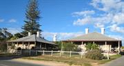
Cockburn Rd Munster
Address includes: 597, 599, Lot 5000 & Lot 5003 Cockburn Rd, Munster. Reserve 24061.
Cockburn
Metropolitan
Constructed from 1902
| Type | Status | Date | Documents |
|---|---|---|---|
| Heritage List | Adopted | 14 Jul 2011 | |
| State Register | Registered | 13 Aug 2004 | HCWebsite.Listing+ListingDocument, HCWebsite.Listing+ListingDocument |
| Type | Status | Date | Documents |
|---|---|---|---|
| (no listings) |
| Type | Status | Date | Grading/Management | |
|---|---|---|---|---|
| Category | ||||
| Other Legal Agreement | Completed | 23 Nov 2004 | ||
| Aboriginal Heritage Sites Register | Permanent | |||
| Municipal Inventory | Adopted | 10 Apr 2014 | Category A | |
| Library Id | Title | Medium | Year Of Publication |
|---|---|---|---|
| 7183 | Lighthouses of Australia : images from the end of an era. | Book | 2001 |
| 8689 | A reflective report on the accompaying Heritage Interpretation Plan : Woodman Point Regional Park. | Heritage Study {Other} | 2007 |
| 8688 | A heritage interpretation plan : Woodman Point Regional Park | Heritage Study {Other} | 2007 |
Individual Building or Group
| Epoch | General | Specific |
|---|---|---|
| Present Use | Transport\Communications | Water: Lighthouse |
| Original Use | RESIDENTIAL | Single storey residence |
| Present Use | RESIDENTIAL | Single storey residence |
| Original Use | Transport\Communications | Water: Lighthouse |
| Style |
|---|
| Federation Bungalow |
| Type | General | Specific |
|---|---|---|
| Other | GLASS | Glass |
| Other | METAL | Steel |
| Roof | METAL | Corrugated Iron |
| Wall | STONE | Limestone |
| General | Specific |
|---|---|
| TRANSPORT & COMMUNICATIONS | River & sea transport |
| OCCUPATIONS | Technology & technological change |
| TRANSPORT & COMMUNICATIONS | Technology & technological change |
This information is provided voluntarily as a public service. The information provided is made available in good faith and is derived from sources believed to be reliable and accurate. However, the information is provided solely on the basis that readers will be responsible for making their own assessment of the matters discussed herein and are advised to verify all relevant representations, statements and information.
Constructed from 1902
Woodman Point Lighthouse has played an important role in the development of shipping and transport services for the region. Woodman Point Lighthouse has been in constant operation since its construction. Woodman Point Lighthouse has significant landmark value. Woodman Point Lighthouse is constructed from locally quarried limestone, creating a strong aesthetic relationship with the surrounding environment. Woodman Point Lighthouse is a representative example of a turn of the 20th century limestone lighthouse.
Woodman Point Lighthouse is a 32 foot high limestone lighthouse, with two associated residences. The lighthouse was the first built in Cockburn and has been in constant operation since its construction. It stands on a limestone hill on the east side of Cockburn Road, slightly north of east in relation to Woodman Point. The structure is cylindrical in shape and made of local stone. It has platforms extending outside the line of the stonework with a guard railing all around. The platform is surmounted by a glass dome housing the lights mechanism. The lighthouse is the only one in Australia with the red and green light sectors reversed, the result of incorrect installation.
Woodman Point Lighthouse has been a prominent and significant landmark within the boundary of the City of Cockburn since it was built in 1902. It was the first lighthouse built within the area. The first lighthouse keepers were Mr Hutchinson and Mr Arthur Dray. They lived at the base of the lighthouse in two cottages built as their residences. The last lighthouse keepers before automation were L. McBride and L. Livesey. As far as can be ascertained it has functioned non-stop since construction and has never been extinguished, even during World War II. Today it is a popular subject for photography and artists and has become a focal point for visitors.
Integrity : High Authenticity : Light added pointing southwest
Very Good
This information is provided voluntarily as a public service. The information provided is made available in good faith and is derived from sources believed to be reliable and accurate. However, the information is provided solely on the basis that readers will be responsible for making their own assessment of the matters discussed herein and are advised to verify all relevant representations, statements and information.
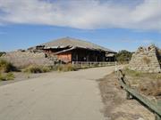
Cockburn Rd Munster
Woodman Pt Reserve 49220
Explosive Magazines (fmr)
Cockburn
Metropolitan
Constructed from 1941 to 1984
| Type | Status | Date | Documents |
|---|---|---|---|
| Heritage List | Adopted | 14 Jul 2011 | |
| State Register | Registered | 27 Dec 2002 | HCWebsite.Listing+ListingDocument, HCWebsite.Listing+ListingDocument |
| Type | Status | Date | Documents |
|---|---|---|---|
| (no listings) |
| Type | Status | Date | Grading/Management | |
|---|---|---|---|---|
| Category | ||||
| Municipal Inventory | Adopted | 10 Apr 2014 | Category A | |
| Name | Type | Year From | Year To |
|---|---|---|---|
| Commonwealth Dept of Interior | Architect | - | - |
| Library Id | Title | Medium | Year Of Publication |
|---|---|---|---|
| 9522 | Woodman Point Regional Park: management plan 2010. | Report | 2010 |
| 8688 | A heritage interpretation plan : Woodman Point Regional Park | Heritage Study {Other} | 2007 |
| 8308 | Woodman Point Recreation Camp (former Woodman Point quarantine station) archival record. | Archival Record | 2006 |
| 6652 | Woodman Point : a regional recreation/conservation park : concept and development plans. | Report | 1988 |
| 8689 | A reflective report on the accompaying Heritage Interpretation Plan : Woodman Point Regional Park. | Heritage Study {Other} | 2007 |
Individual Building or Group
| Epoch | General | Specific |
|---|---|---|
| Original Use | MINING | Other |
| Other Use | MILITARY | Magazine or Store |
| Other Use | SOCIAL\RECREATIONAL | Other |
| Present Use | VACANT\UNUSED | Vacant\Unused |
| Style |
|---|
| Other Style |
| Type | General | Specific |
|---|---|---|
| Other | GLASS | Glass |
| Other | METAL | Wrought Iron |
| Other | TIMBER | Other Timber |
| Roof | ASBESTOS | Fibrous Cement, corrugated |
| Wall | CONCRETE | Other Concrete |
| Roof | METAL | Steel |
| Wall | BRICK | Common Brick |
| General | Specific |
|---|---|
| OCCUPATIONS | Mining {incl. mineral processing} |
| OUTSIDE INFLUENCES | World Wars & other wars |
This information is provided voluntarily as a public service. The information provided is made available in good faith and is derived from sources believed to be reliable and accurate. However, the information is provided solely on the basis that readers will be responsible for making their own assessment of the matters discussed herein and are advised to verify all relevant representations, statements and information.
Constructed from 1941, Constructed from 1984
Explosives Magazines played an important role in the country’s defence effort during World War II as a storage facility for cordite, used in the manufacture of munitions at a factory in Welshpool. Explosives Magazines is unique in that the buildings constructed at Woodman Point for the Commonwealth Department of the Interior at the outbreak of World War II are the only munitions magazines ever built within Western Australia to such a design. Explosives Magazines, in combination with the remnants of the barrier berms and railway sidings from the original explosives reserve, creates a distinctive landscape which strongly reflects the explosives storage history of the locality. Explosives Magazines is historically significant, having demonstrated a regard for choice of building materials and innovative design elements suited to withstanding high temperatures and protection of the stored volatile materials from risks associated with fire. Explosives Magazines played a significant role in the military defence operations of Western Australia during World War II.
The Woodman Point Explosives Reserve encompassed the land around the jetty and the magazines (the jetty is situated outside the Reserve area and is under the control of the Department of Transport, Marine Division). The three explosives magazines are set back from the beach in the sand dunes. They are surrounded by sandbag barriers. The red brick buildings have very thick walls and high set windows. The roofs are asbestos. The buildings now stand vacant. They have been adversely affected by vandalism and are a haven for graffiti artists.
Explosives for the purpose of loosening ore on the goldfields were initially transported to Robbs Jetty by wooden hulled sailing vessels. After being stored in an old ship hulk, the explosives were then stored in magazines originally situated among huge sand hills where the meat exporting works now stands. Following an explosion in which a man was killed, the magazines were moved in 1903-04 to the present site on Woodman Point by bullock teams. The brick magazines were built in 1941. Woodman Point was previously the site of the Fremantle Race Club. Though the club had made some improvements they had no title to the land. The land was not considered ideal for a race course owing to its sandy nature and it was used infrequently for cabmen's races. It was chosen as an ideal site for the magazines owing to its close proximity to Robbs Jetty. The Fremantle Race Club gave up their 99 year lease for £1,000 compensation. The purpose of the explosives magazines was to store, sample and test explosives being imported into the state. If explosives deteriorated en route they were held in the magazines while the inspections were carried out. If they were classified unstable they were destroyed on the nearby beach. If approved, the explosives were loaded into rail vans to be transported to mining centres throughout the state. With the building of a jetty the explosives could be brought to the magazines directly. At first the explosives were transferred to lighters which ferried the cargo to the jetty. The cargo was then loaded onto horse drawn rail wagons and taken to the magazines. In later years the lighters were replaced by small motor vessels which could berth at the jetty and the horses were replaced by tractors. During World War II the location of the explosives magazine caused problems for the district as it was a recognised strategic target for the enemy. As a result, Coogee Primary School was relocated until after the end of the war. In the late 1970s part of the magazine was leased out to a fireworks expert, who was unfortunately killed when his stock ignited. By the 1970s, with the growing population of Cockburn, then 25,000, there was a need to provide recreational facilities. Woodman Point was recognised as having recreation potential, so in 1984 the Mines Department relocated the explosives depot to Baldivis. The buildings now stand empty and derelict. They represent a significant period in the early development of the mining industry in Western Australia. Recreational facilities have been developed on Woodman Point including parkland and BBQs. There is some natural bush that has been retained including some very old tuart trees.
INTEGRITY: Most fabric intact
Poor
| Name | Type | Year From | Year To |
|---|---|---|---|
| Commonwealth Dept of Interior | Architect | - | - |
| Ref ID No | Ref Name | Ref Source | Ref Date |
|---|---|---|---|
| HCWA assessment ; " Woodman Point Munitions Magazines (fmr)". | State Heritage Office |
| Owner | Category |
|---|---|
| Minister for Sport & Recreation | State Gov't |
This information is provided voluntarily as a public service. The information provided is made available in good faith and is derived from sources believed to be reliable and accurate. However, the information is provided solely on the basis that readers will be responsible for making their own assessment of the matters discussed herein and are advised to verify all relevant representations, statements and information.
O'Kane Ct Munster
Address includes: 132 & Lot 50 Cockburn Rd, Munster; Lots 57 & 181 Woodman Point Vew, Munster; Lots 180, 300 & 301 O'Kane Court, Munster
Woodman Point Recreation Camp
Cockburn
Metropolitan
Constructed from 1886 to 1923
| Type | Status | Date | Documents |
|---|---|---|---|
| Heritage List | Adopted | 14 Jul 2011 | |
| State Register | Registered | 31 Mar 2006 | HCWebsite.Listing+ListingDocument, HCWebsite.Listing+ListingDocument |
| Type | Status | Date | Documents |
|---|---|---|---|
| (no listings) |
| Type | Status | Date | Grading/Management | |
|---|---|---|---|---|
| Category | ||||
| Municipal Inventory | Adopted | 10 Apr 2014 | Category A | |
| Register of the National Estate | Nominated | 28 Jul 1983 | ||
| Classified by the National Trust | Classified | 08 Mar 1983 | ||
| Register of the National Estate | Registered | 26 Oct 1999 | ||
Fair
| Name | Type | Year From | Year To |
|---|---|---|---|
| W. B. Hardwick | Architect | - | - |
| Library Id | Title | Medium | Year Of Publication |
|---|---|---|---|
| 7913 | Specification: additions and alterations to Woodman Point Recreation Camp for Department of Sport and Recreation. | Heritage Study {Other} | 2005 |
| 7945 | Hazardous materials. Additions and alterations to Woodman Point recreation camp for Department of Sport and Recreation. | Heritage Study {Other} | 2005 |
| 9424 | The enigma of Clarence: Woodman Point or Mount Brown? | Journal article | 2008 |
| 883 | An assessment of cultural significance and a conservation plan for Woodman Point Recreation Camp ( the Former Woodman's Point Quarantine Station). | Heritage Study {Cons'n Plan} | 1995 |
| 6652 | Woodman Point : a regional recreation/conservation park : concept and development plans. | Report | 1988 |
| 7573 | The hidden community : Woodman Point Quarantine Station, Munster, Western Australia. | Heritage Study {Other} | 2005 |
| 5793 | Woodman Point Regional Park : draft management plan 2002-2012. | Report | 2002 |
| 9905 | The hidden community - Woodman Point quarantine station. | Journal article | 2010 |
| 9522 | Woodman Point Regional Park: management plan 2010. | Report | 2010 |
| 8308 | Woodman Point Recreation Camp (former Woodman Point quarantine station) archival record. | Archival Record | 2006 |
| 8307 | Woodman Point recreation camp (former quarantine station) report on colour investigation and proposal for new interpretive colour scheme. | Report | 2006 |
Individual Building or Group
| Epoch | General | Specific |
|---|---|---|
| Original Use | GOVERNMENTAL | Other |
| Original Use | GOVERNMENTAL | Quarantine Station |
| Present Use | SOCIAL\RECREATIONAL | Other |
| Style |
|---|
| Victorian Regency |
| Inter-War California Bungalow |
| Post-War International |
| Type | General | Specific |
|---|---|---|
| Wall | BRICK | Common Brick |
| Roof | METAL | Corrugated Iron |
| Wall | STONE | Limestone |
| Wall | ASBESTOS | Fibrous Cement, flat |
| Roof | ASBESTOS | Fibrous Cement, corrugated |
| General | Specific |
|---|---|
| TRANSPORT & COMMUNICATIONS | River & sea transport |
| SOCIAL & CIVIC ACTIVITIES | Sport, recreation & entertainment |
| DEMOGRAPHIC SETTLEMENT & MOBILITY | Immigration, emigration & refugees |
| DEMOGRAPHIC SETTLEMENT & MOBILITY | Government policy |
| OTHER | Other Sub-Theme |
| OUTSIDE INFLUENCES | Refugees |
This information is provided voluntarily as a public service. The information provided is made available in good faith and is derived from sources believed to be reliable and accurate. However, the information is provided solely on the basis that readers will be responsible for making their own assessment of the matters discussed herein and are advised to verify all relevant representations, statements and information.
Constructed from 1886, Constructed from 1923
Quarantine Station (fmr) is a rare example of a quarantine station in Western Australia and played an important role for nearly 100 years in preventing the spread of contagious infections and diseases. Quarantine Station (fmr) demonstrates quarantine practices from the late 19th century to the 1970s and provides evidence of 19th century burial practices for those who died in quarantine. Quarantine Station (fmr) includes a substantial and intact complex of similarly designed and distinctive early 20th century buildings and is nestled in a picturesque natural coastal environment.
Land was reserved for a quarantine station at Woodman’s Point in 1876 and the first buildings were erected in 1886. They were added to and updated from time to time over the years, a major expansion taking place during World War I. The station finally closed in 1979. The Quarantine Station is set on a large area of land on Woodman Point. The majority of the buildings are asbestos clad with corrugated asbestos roofs. They are a basic design and very few have verandahs. Amongst the older buildings are some more modern structures which still maintain the simple uncluttered architecture of the original buildings. While the buildings hold an inherent technical interest, they also form a group in an attractive setting, close to the ocean with adjoining bushland. The bushland has been well protected by the restricted access to the site and this has added to its natural ecological value. There are a number of species of plants and animals which flourish undisturbed in the bushland. The buildings in the main complex are the accommodation blocks for passengers, seamen’s quarters, former residence for medical officer (now offices) and surgery, dining hall with attached kitchens, scullery, pantries, laundry, fumigation block, ablution block and a recreation building. Part of the stone fence which originally enclosed the central buildings remains on the south eastern side. At a little distance to the east from the central section is an enclosure containing the isolation hospital and a detention centre and to the northeast is a former medical officer's residence. In the central section there are also newer structures such as garages, sheds for machinery and plant and a house occupied by the caretaker, which is not in character with the original buildings. There is also a modern kitchen block which was designed sympathetically. The buildings and the grounds are well maintained. Notable features are the dining hall with its fine polished jarrah floor and timber ceiling, which has been painted white, the ablution block with its cubicles, and the fumigation block. Not to be forgotten are some graves of people who died while at the station. These are listed in the Lonely Graves of Western Australia reference. The grave markers range from headstones to simple wooden crosses.
Land was reserved for a quarantine station at Woodman Point in 1876. (In 1827, Stirling named the Point after Thomas Woodman, the purser of the Success). The first buildings of the Quarantine Station were erected in 1886 on advice from the medical authorities. The aim was to isolate plague sufferers from the mainstream of hospital patients at Fremantle. Those who died of contagious diseases at the Station were cremated in the crematorium which is well preserved to this day. The presence of the crematorium was quite unique at that time because cremation was still a very uncommon practice during the 1920s. It was considered against the doctrine of the resurrection of the body and reconciliation with the soul on the day of the Last Judgement. The crematorium was last used in 1943. Within the confines of the station are some graves. These are listed in ‘Lonely Graves of Western Australia’. One of the graves is that of Sister Rosa O’Kane the source of the name of O’Kane Court in Munster, the official address of the Quarantine Station. The existing complex of buildings was built in the post WWI period before 1923. All buildings have had their original exteriors replaced with asbestos cladding and roofing. The Station is of historical interest in that it played a great part in the public health system of WA for 100 years until it closed on 1979. Quarantine Stations as a class of institutions are in themselves relatively scarce in Australia. The station is one of a small number of examples of Federation and Western Australian immigration peculiarities. It can be regarded as evidence of a function no longer practised. The quarantine station is also of interest in its records of outbreaks of diseases such as scarlet fever, small pox, bubonic plague and Spanish influenza after WWI. In more recent years Vietnamese refugees landing on the Western Australian coast were held until cleared of possible health problems. The experience of the people detained in the station varied greatly. Some regarded it as a detention/concentration camp while others expressed a different opinion. Athol Thomas, a reporter for the West Australian in 1969, said the station was more like a holiday camp. He was referring to the 230 acres of bushland surrounding the station which included restricted water in which ‘guests’ could swim, fish and sail. The quarantine station was closed down as isolation could be done within local hospitals or at Fairfield in Victoria. The Woodman Point area was purchased from the Commonwealth Government for $2.5 million and vested in the Department of Youth, Sport and Recreation. The area is now used as a recreational camp.
INTEGRITY: Many modifications but original buildings kept AUTHENTICITY: Original buildings replaced 1919-23
Good
| Ref ID No | Ref Name | Ref Source | Ref Date |
|---|---|---|---|
| National Trust Assessment, & various newspaper articles attached to National Trust Assessment Form | National Trust WA | ||
| HCWA Database No. 499 | State Heritage Office | ||
| "Conservation Plan for Woodman Point Recreation Camp". |
| Owner | Category |
|---|---|
| Conservation Commission of Western AustraliaConservation Commission of Western Australia | State Gov't |
| Department of Youth, Sport and Recreation. | State Gov't |
This information is provided voluntarily as a public service. The information provided is made available in good faith and is derived from sources believed to be reliable and accurate. However, the information is provided solely on the basis that readers will be responsible for making their own assessment of the matters discussed herein and are advised to verify all relevant representations, statements and information.
The crematorium and cemeteries at Woodman Point Quarantine Station (fmr) have cultural heritage significance for the following reasons: • the crematorium has rarity value as Australia’s first crematorium and this intact facility is therefore the nation’s oldest extant crematorium. • the place demonstrates the development of quarantine procedures and Western Australia’s quarantine requirements for the sanitary disposal of those who died from infectious disease in Western Australia from colonial times until World War II, particularly during the bubonic plague and Spanish influenza pandemics in the early parts of the twentieth century; • the place is a focus of cultural sentiment for the families of those who died at the former quarantine station, and to those interested in the site’s human tragedy; and • the place has the capacity to reveal aspects associated with the history of public health, undertaking and cremation in Australia by means of its tangible and intangible elements.
Assessment 2006: Crematorium and cemeteries
This information is provided voluntarily as a public service. The information provided is made available in good faith and is derived from sources believed to be reliable and accurate. However, the information is provided solely on the basis that readers will be responsible for making their own assessment of the matters discussed herein and are advised to verify all relevant representations, statements and information.
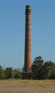
82 Bennett Av North Coogee
Formerly Hamilton Hill.
Robb Jetty Abattoir
Cockburn
Metropolitan
Constructed from 1919
| Type | Status | Date | Documents |
|---|---|---|---|
| Heritage List | Adopted | 14 Jul 2011 | |
| State Register | Registered | 18 Jan 2021 | HCWebsite.Listing+ListingDocument, HCWebsite.Listing+ListingDocument |
| Type | Status | Date | Documents |
|---|---|---|---|
| (no listings) |
| Type | Status | Date | Grading/Management | |
|---|---|---|---|---|
| Category | ||||
| Municipal Inventory | Adopted | 10 Apr 2014 | Category A | |
Fair.
| Library Id | Title | Medium | Year Of Publication |
|---|---|---|---|
| 7490 | Cockburn vision dialogue : workshop papers. | Loose-leaf | 2005 |
| 9101 | Cockburn coast: reborn. | Report | 2008 |
| 1313 | The Robb Jetty abattoir site : archaeological report. | Report | 1995 |
| 10132 | Robb's Jetty Abattoir | Heritage Study {Other} | 0 |
| 10036 | The changing Cockburn Coast. Appendices - European Heritage | Electronic | 2008 |
| 9148 | The changing Cockburn coast: Aborignal and European heritage in the Cockburn region. | Heritage Study {Other} | 2008 |
| 9147 | Cockburn Coast: draft district structure plan | Book | 2008 |
| 9102 | Cockburn coast: regional framework. | Report | 2008 |
Individual Building or Group
| Epoch | General | Specific |
|---|---|---|
| Present Use | VACANT\UNUSED | Vacant\Unused |
| Original Use | INDUSTRIAL\MANUFACTURING | Abbatoir |
| Style |
|---|
| Other Style |
| Type | General | Specific |
|---|---|---|
| Wall | BRICK | Common Brick |
| General | Specific |
|---|---|
| OCCUPATIONS | Manufacturing & processing |
This information is provided voluntarily as a public service. The information provided is made available in good faith and is derived from sources believed to be reliable and accurate. However, the information is provided solely on the basis that readers will be responsible for making their own assessment of the matters discussed herein and are advised to verify all relevant representations, statements and information.
Constructed from 1919
Robb Jetty Chimney is the sole remaining structure of the Robb Jetty Abattoir, and is a visual reminder and marker of the former complex. Robb Jetty Chimney contributes to the community's sense of place and history. Robb Jetty Chimney is a significant landmark in the area.
The Robb Jetty Chimney, a tall red brick boiler house chimney, is the sole remaining structure of the Robb Jetty Abattoir.
The Abattoir and the associated landing place for cattle and sheep from stations in the north of the State was, for over 100 years, a significant component in the meat industry in Western Australia. The Abattoir was a major source of employment, and the place contributed strongly to the identity of the region. Following closure of the abattoir and redevelopment of the land Robb Jetty Chimney, is all that remains of the abattoir complex. For more details see Fiona Bush and Martin Gibbs: 'The Robb Jetty Abattoir' (Heritage Council of Western Australia, October 1995).
INTEGRITY: Remnant only AUTHENTICITY: High
Fair
| Ref ID No | Ref Name | Ref Source | Ref Date |
|---|---|---|---|
| F Bush & M Gibbs; "The Robb Jetty Abbatoir". | State Heritage Office | October 1995 | |
| National Trust WA Assessment Documentation |
| Owner | Category |
|---|---|
| WA Land Authority (Landcorp) | State Gov't |
This information is provided voluntarily as a public service. The information provided is made available in good faith and is derived from sources believed to be reliable and accurate. However, the information is provided solely on the basis that readers will be responsible for making their own assessment of the matters discussed herein and are advised to verify all relevant representations, statements and information.
C.Y O'Connor Beach North Coogee
Wyola Steam Tug
Cockburn
Metropolitan
| Type | Status | Date | Documents |
|---|---|---|---|
| Heritage List | Adopted | 10 Apr 2014 |
| Type | Status | Date | Documents |
|---|---|---|---|
| (no listings) |
| Type | Status | Date | Grading/Management | |
|---|---|---|---|---|
| Category | ||||
| Municipal Inventory | Adopted | 11 Sep 2014 | Category B | |
16120 South Beach Horse Exercise Area
Historic Site
| Epoch | General | Specific |
|---|---|---|
| Original Use | Transport\Communications | Water: Other |
| Type | General | Specific |
|---|---|---|
| Other | (none) |
| General | Specific |
|---|---|
| TRANSPORT & COMMUNICATIONS | River & sea transport |
This information is provided voluntarily as a public service. The information provided is made available in good faith and is derived from sources believed to be reliable and accurate. However, the information is provided solely on the basis that readers will be responsible for making their own assessment of the matters discussed herein and are advised to verify all relevant representations, statements and information.
16120 South Beach Horse Exercise Area
Wyola and Barge (remains) have historical significance as a tangible and visible reminder of the maritime history associated with Owen Anchorage. The Wyola is associated with both World Wars and had a long and important association with the Fremantle Harbour shipping industry, through its involvement in long-distance towing, salvage and rescue. The remains of the hull of the Wyola form a landmark on C. Y. O’Connor Beach, and have aesthetic and interpretive significance. Wyola Wreck and Barge (remains) have social value as a publicly accessible landmark, contributing to the community’s sense of place. The timber barge has social and historic significance for its association with shipbreaking activities and Cockburn’s maritime industrial heritage.
The Wyola was a 306–ton steam tug built in South Shields, England in 1912. The remains of the Wyola are evident at C. Y. O’Connor beach, with the stern frame protruding from the beach with the bottom of the hull buried in the sand. A timber barge buried in the sand just to the north and sometimes visible is said to have been used in the scrapping of the Wyola. A timber barge buried in the sand just to the north of the Wyola is believed to have been used by the Goldfield Metal Traders company in the course of their scrapping of the Wyola.
The Wyola was built in South Shields, England, in 1912, with its steam engine constructed by Shield’s Engineering for the Swan River Shipping Co Ltd, of Perth. The Wyola, was brought out from England by Captain Billett and arrived in Fremantle Port on 5 October 2012. Its arrival was announced in the West Australian on 8 October 1912, where it was described as being ‘a splendid type in her class, and admittedly one of the most powerful tugs in Australasia… her engines are the latest and most approved type, and fitted with Brown’s rovering gear, which enables the vessel to be easily and expeditiously handled.’ According to the article, the Wyola was fitted with an up-to-date salvage plant, and was also designed with large decks and accommodation that made it suitable as an excursion steamer. The salvage plant consisted of a powerful pump which could be used to flood a burning ship or empty a sunken ship. In a newspaper article in 1946 the Wyola was described as one of the busiest craft in the harbour, the Wyola served in World War I in the Mediterranean and the Dardanelles. During the busy war years the Wyola handled all types of vessels, wartime requirements calling for work at all hours in and out of harbour. Captain Carl Frederick Douglas of East Fremantle was the skipper of the Wyola for 36 years from 1915 to 1951 when he retired at the age of 68 after 55 years at sea. The Wyola’s registry was cancelled on the 25 September 1970 as the vessel was run ashore at C. Y. O’Connor Beach near Robb Jetty where it was scrapped and broken up. Until 2012 the stern frame was still seen protruding from the beach while the bottom of the hull lies buried in the sand. A timber barge buried in the sand just to the north and sometimes visible is said to have been used in the scrapping of the Wyola. In 2012 after concerns regarding safety, particularly for use of the beach as a horse exercise area, the City of Cockburn excavated sand from around the remains of the wreck and removed a large section of the wreck to make it safer.
Low
Poor
This information is provided voluntarily as a public service. The information provided is made available in good faith and is derived from sources believed to be reliable and accurate. However, the information is provided solely on the basis that readers will be responsible for making their own assessment of the matters discussed herein and are advised to verify all relevant representations, statements and information.
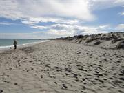
South Beach North Coogee
Formerly Hamilton Hill.
South Beach
Cockburn
Metropolitan
Constructed from 1833
| Type | Status | Date | Documents |
|---|---|---|---|
| Heritage List | Adopted | 14 Jul 2011 | |
| State Register | Registered | 30 Mar 2007 | HCWebsite.Listing+ListingDocument, HCWebsite.Listing+ListingDocument |
| Type | Status | Date | Documents |
|---|---|---|---|
| (no listings) |
| Type | Status | Date | Grading/Management | |
|---|---|---|---|---|
| Category | ||||
| Municipal Inventory | Adopted | 10 Apr 2014 | Category A | |
C Y O’Connor Beach Horse Exercise Area was traditionally used rather than managed in any formal sense. Since the construction of the South Fremantle Power Station and development of C Y O’Connor Beach (formerly South Beach), the area available for the uses has been reduced and in recent times management regimes have been put in place to prevent dune erosion and to rehabilitate the natural environment. The formalisation of the tracks has detracted from and restricted the former manner of use. Overall the place is in fair to good condition.
| Library Id | Title | Medium | Year Of Publication |
|---|---|---|---|
| 9101 | Cockburn coast: reborn. | Report | 2008 |
| 7023 | Images CD No. 27 : assessment images : Hillcrest, Homeleigh, South Beach. | C D Rom | 2004 |
| 9917 | Survey of the Port Coogee development area. | Electronic | 2006 |
| 10036 | The changing Cockburn Coast. Appendices - European Heritage | Electronic | 2008 |
| 7467 | Fremantle : beyond the Round House. | Book | 2005 |
Landscape
| Epoch | General | Specific |
|---|---|---|
| Present Use | SOCIAL\RECREATIONAL | Other |
| Style |
|---|
| Other Style |
| Type | General | Specific |
|---|---|---|
| Other | OTHER | Other Material |
| General | Specific |
|---|---|
| PEOPLE | Famous & infamous people |
| SOCIAL & CIVIC ACTIVITIES | Sport, recreation & entertainment |
| DEMOGRAPHIC SETTLEMENT & MOBILITY | Aboriginal Occupation |
| PEOPLE | Local heroes & battlers |
| OUTSIDE INFLUENCES | World Wars & other wars |
| TRANSPORT & COMMUNICATIONS | River & sea transport |
| PEOPLE | Early settlers |
| PEOPLE | Aboriginal people |
| DEMOGRAPHIC SETTLEMENT & MOBILITY | Racial contact & interaction |
This information is provided voluntarily as a public service. The information provided is made available in good faith and is derived from sources believed to be reliable and accurate. However, the information is provided solely on the basis that readers will be responsible for making their own assessment of the matters discussed herein and are advised to verify all relevant representations, statements and information.
The beach remains an important part of the natural coastline surrounding Cockburn Sound. This particular stretch of beach has many associations with the horse racing community and represents a continuous link with the past. The beach is still used as a horse beach as horses from Randwick Stables are still walked to the beach along the same routes they have taken since the 1920s. The memorials were erected to commemorate the historical significance of South Beach and to emphasise the links with C. Y. O’Connor and the horse racing industry. The beach is a representative of a unique aspect of the history of the Cockburn and Fremantle area.
South Beach is a managed coastal landscape of tracks, parks, beach facilities, groynes, public art, fenced and unfenced tracks, dune vegetation and re-vegetation, and a beach with archaeological remains. It was the site of the first official horse race in WA in October 1833 and has been used for exercise and training of horses, both recreational and sporting, in particular horse racing from that time to the present The Beach is the site of two monuments, one to C. Y. O’Connor and the other to horses. The horse monument is situated in front of old South Fremantle Power Station, and depicts seven riders on seven horses. The C. Y. O’Connor monument is situated in the ocean and depicts O’Connor on a horse.
South Beach is a well used public beach marked by two bronze monuments depicting the connections between the beach and the horse racing/training industry (artist Anne Neil) and C. Y. O’Connor’s final ride and suicide site (artist Tony Jones). The beach was first used as a horse racing ‘track’ on 3 October 1833 only four years after the foundation of the Swan River Colony. The contestants in the race were imported Timor Ponies. The field of seven raced twice around a half mile course for a purse of five sovereigns. On 10 March 1902 C. Y. O’Connor rode into the water off South Beach and shot himself. In World War I the 10th Light Horse Group was camped at Woodman Point. They trained on the beach from Woodman Point to Robb Jetty. The following memories of South Beach were written by Jimmy Banks a horse trainer that has lived in the Cockburn or South Fremantle district for many decades: My memory of South Beach goes back to the early 1930s. South Beach at this time was the most popular and safest beach for children in the metropolitan area. Summer time saw the beach full with young families enjoying a long stretch of white sand, grassed areas large shady trees and a shallow beach for children to safely swim. It also had, unique from other local beaches, a shark proof swimming area. The shark proof net ran from alongside the jetty and enclosed a large area that was well lit at night. I learned to swim by dog paddling around it. There was a railway station there and loads of people would arrive by train to enjoy a day’s swimming and on hot nights to enjoy the benefits of a sea breeze. It was also connected to East Fremantle by tram. A big attraction was the carnival atmosphere with side shows, merry-go-rounds and various other amusements. There was a two storey wooden structure called a hydrodome where cool drinks, lollies, ice-creams and snacks could be bought. It also contained change rooms and dances were held regularly. The railway station provided the racing people and their horses a means of transport to the race meetings. The horses were loaded and taken to both metropolitan and country racecourses. The station held great fascination for me, as I was horse mad. The Irish Police Sergeant was always chasing my mates and I away, and many a time I felt his big hand giving me a good smack on my bottom, but it didn’t deter us as we were back as soon as the coast was clear. Not far from the beach the horses that pulled Manford’s lorries were stabled and on Sundays we boys were privileged to take these gentle giants to South beach for a swim. Racehorse trainers in the Fremantle district used South Beach as a great working facility. Horses from stables in Fremantle, White Gum Valley, East Fremantle, Hamilton Hill and South Fremantle were regularly worked there with excellent results. From James Rocks to Robb Jetty was a straight 6.5-7 furlong and if the tide was out the horses could gallop four to five abreast (of course this was before the building of the South Fremantle Power Station Place, Record Number 75). After they were worked the horses were given a quick dip in the ocean before returning home, of course the horses were walked to and from the beach as floats were nonexistent in those days. Further history recalled about South Beach includes the recollection that there were a number of pensioners living near the beach in roughly built shacks. The shacks were built from material located at the tip and the people relied on ground water from wells. The shacks were located at the south end of the beach near the old smelters and hence the nick name Smelters Camp. People from outside the district that came to the beach included people from the goldfields that made South Beach their annual holiday destination to stay at boarding houses close to the beach. The Midland Railway Workshop also held their annual picnic at South Beach.
| Ref ID No | Ref Name | Ref Source | Ref Date |
|---|---|---|---|
| J Banks; "South Beach: APersonal History". | 2001 | ||
| C Day; "Oral History Interview withTerry Patterson". | Heritage Today | 8/4/2002 | |
| M Tauman; "The Chief CY O'Connor". | West Australian | 19/6/1999 | |
| Alison Bolas, Information supplied to HCWA. | 2002 |
| Owner | Category |
|---|---|
| City of Cockburn | Local Gov't |
| Dep't for Planning & Infrastructure | State Gov't |
This information is provided voluntarily as a public service. The information provided is made available in good faith and is derived from sources believed to be reliable and accurate. However, the information is provided solely on the basis that readers will be responsible for making their own assessment of the matters discussed herein and are advised to verify all relevant representations, statements and information.
Lot 164 Azelia Rd Spearwood
Cockburn
Metropolitan
Constructed from 1866
| Type | Status | Date | Documents |
|---|---|---|---|
| (no listings) |
| Type | Status | Date | Documents |
|---|---|---|---|
| (no listings) |
| Type | Status | Date | Grading/Management | |
|---|---|---|---|---|
| Category | ||||
| (no listings) | ||||
00533 Manning Estate, Hamilton Hill
| Name | Type | Year From | Year To |
|---|---|---|---|
| Manning, L.A. | Architect | - | - |
| Library Id | Title | Medium | Year Of Publication |
|---|---|---|---|
| 11385 | Archaeological management strategies for Davilak Ruins, Manning Estate, Hamilton Hill | Heritage Study {Other} | 2014 |
| 10036 | The changing Cockburn Coast. Appendices - European Heritage | Electronic | 2008 |
Individual Building or Group
| Epoch | General | Specific |
|---|---|---|
| Original Use | FARMING\PASTORAL | Homestead |
| Present Use | VACANT\UNUSED | Vacant\Unused |
This information is provided voluntarily as a public service. The information provided is made available in good faith and is derived from sources believed to be reliable and accurate. However, the information is provided solely on the basis that readers will be responsible for making their own assessment of the matters discussed herein and are advised to verify all relevant representations, statements and information.