Local Government
Coolgardie
Region
Goldfields
Off Great Eastern Hwy Boondi
Coolgardie
Goldfields
Constructed from 1899
| Type | Status | Date | Documents |
|---|---|---|---|
| (no listings) |
| Type | Status | Date | Documents |
|---|---|---|---|
| RHP - To be assessed | Current | 27 Aug 2004 |
| Type | Status | Date | Grading/Management | |
|---|---|---|---|---|
| Category | ||||
| (no listings) | ||||
The place has associations with the establishment of the railway network to the Eastern Goldfields during the gold boom of the 1890s.
The place forms part of system of reservoirs and dams established to provide water for the steam engines that once operated on the railway; a function which is no longer practised.
The place is a good example of 1 dam and 1 rock catchment.
□ Stone lined dam with rock slab channel connection to granite outcrop and a rock slab overflow at opposite end of the dam. □The site contains one dam and one rock catchment.
In 1887 gold was discovered at Yilgarn and in 1888 the area was proclaimed a goldfield. Arthur Bayley and John Ford discovered gold in 1892 at Fly Flat (now known as Coolgardie). Shortly after this in 1894, Hannan, Flannigan and O’Shea found gold at Kalgoorlie leading to one of the biggest goldrushes in the state's history. This gold boom brought many people from throughout the state and the Eastern States to the Goldfields. The high population and a lack of fresh water due to the low rainfall and a lack of a permanent water source caused serious health and general living problems. A variety of alternative water sources were considered including condensing water, digging bores and carting water, but none were sufficient to meet the needs. This led to Premier Forrest's request to CY O'Connor, Engineer in Chief, to design and construct a water supply scheme to the goldfields. The Goldfields Water Supply Scheme was opened in 1903. The goldrush meant an increase in traffic between Perth and Kalgoorlie. Many walked or rode bicycles to the goldfields, but the increase in population meant supplies, material and water as well as people needed to be transported. The existing railway over the Darling Range was inadequate. CY O'Connor surveyed a route for a new railway line, replacing the one over the Darling Range and continuing on to Kalgoorlie which was opened in 1896. The steam trains used more than half the water they were able to carry and so an alternative water supply was needed. A series of dams and rock catchments were constructed. These utilized naturally formed granite outcrops. Low stone walls were built around the perimeter of the rock (sometimes two adjacent rocks were used). The water captured by the walls was directed into stone lined channels to either one or two dams or reservoirs. In some instances creeks were dammed to provide the water source. The water was pumped from these dams to tanks located beside the railway line. These pumps and the catchments itself were often maintained by a caretaker who lived on site. As places where water was available on the route to the goldfields, small settlements often developed around them. A number of these rock catchments and dams are now used regularly as recreation areas. Two (Karalee and Merredin) are included as sites on the National Trust's Golden Pipeline Heritage Trail.
Integrity- Moderate Authenticity- High
Good - Dam walls have disintegrated in places.
Historic site
| Epoch | General | Specific |
|---|---|---|
| Present Use | GOVERNMENTAL | Reservoir or Dam |
| Original Use | GOVERNMENTAL | Reservoir or Dam |
| Type | General | Specific |
|---|---|---|
| Wall | CONCRETE | Other Concrete |
| General | Specific |
|---|---|
| TRANSPORT & COMMUNICATIONS | Rail & light rail transport |
This information is provided voluntarily as a public service. The information provided is made available in good faith and is derived from sources believed to be reliable and accurate. However, the information is provided solely on the basis that readers will be responsible for making their own assessment of the matters discussed herein and are advised to verify all relevant representations, statements and information.
Great Eastern Hwy Boorabbin
Coolgardie
Goldfields
Constructed from 1895
| Type | Status | Date | Documents |
|---|---|---|---|
| (no listings) |
| Type | Status | Date | Documents |
|---|---|---|---|
| RHP - To be assessed | Current | 27 Aug 2004 |
| Type | Status | Date | Grading/Management | |
|---|---|---|---|---|
| Category | ||||
| (no listings) | ||||
The place has associations with the establishment of the railway network to the Eastern Goldfields during the gold boom of the 1890s.
The place forms part of system of reservoirs and dams established to provide water for the steam engines that once operated on the railway; a function which is no longer practised.
As with the other dams along the line, the place is now used as a recreation spot by visitors.
□ The place comprises a granite water catchment area, two associated dams and stone water channels. □ The catchment walls and the dam retaining walls are of stone construction. □ The site contains 2 dams and 1 rock catchment.
In 1887 gold was discovered at Yilgarn and in 1888 the area was proclaimed a goldfield. Arthur Bayley and John Ford discovered gold in 1892 at Fly Flat (now known as Coolgardie). Shortly after this in 1894, Hannan, Flannigan and O’Shea found gold at Kalgoorlie leading to one of the biggest goldrushes in the state's history. This gold boom brought many people from throughout the state and the Eastern States to the Goldfields. The high population and a lack of fresh water due to the low rainfall and a lack of a permanent water source caused serious health and general living problems. A variety of alternative water sources were considered including condensing water, digging bores and carting water, but none were sufficient to meet the needs. This led to Premier Forrest's request to CY O'Connor, Engineer in Chief, to design and construct a water supply scheme to the goldfields. The Goldfields Water Supply Scheme was opened in 1903. The goldrush meant an increase in traffic between Perth and Kalgoorlie. Many walked or rode bicycles to the goldfields, but the increase in population meant supplies, material and water as well as people needed to be transported. The existing railway over the Darling Range was inadequate. CY O'Connor surveyed a route for a new railway line, replacing the one over the Darling Range and continuing on to Kalgoorlie which was opened in 1896. The steam trains used more than half the water they were able to carry and so an alternative water supply was needed. A series of dams and rock catchments were constructed. These utilized naturally formed granite outcrops. Low stone walls were built around the perimeter of the rock (sometimes two adjacent rocks were used). The water captured by the walls was directed into stone lined channels to either one or two dams or reservoirs. In some instances creeks were dammed to provide the water source. The water was pumped from these dams to tanks located beside the railway line. These pumps and the catchments itself were often maintained by a caretaker who lived on site. As places where water was available on the route to the goldfields, small settlements often developed around them. A number of these rock catchments and dams are now used regularly as recreation areas. Two (Karalee and Merredin) are included as sites on the National Trust's Golden Pipeline Heritage Trail.
High
Poor
Historic site
| Epoch | General | Specific |
|---|---|---|
| Present Use | GOVERNMENTAL | Reservoir or Dam |
| Original Use | GOVERNMENTAL | Reservoir or Dam |
| Type | General | Specific |
|---|---|---|
| Wall | STONE | Local Stone |
| General | Specific |
|---|---|
| TRANSPORT & COMMUNICATIONS | River & sea transport |
This information is provided voluntarily as a public service. The information provided is made available in good faith and is derived from sources believed to be reliable and accurate. However, the information is provided solely on the basis that readers will be responsible for making their own assessment of the matters discussed herein and are advised to verify all relevant representations, statements and information.
30 km West of Coolgardie Bullabulling
Bullabulling
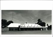
Rock Tavern
Coolgardie
Goldfields
Constructed from 1907
| Type | Status | Date | Documents |
|---|---|---|---|
| (no listings) |
| Type | Status | Date | Documents |
|---|---|---|---|
| (no listings) |
| Type | Status | Date | Grading/Management | |
|---|---|---|---|---|
| Category | ||||
| Municipal Inventory | Adopted | 27 Jul 1995 | Category 2 | |
| Statewide Hotel Survey | Completed | 01 Nov 1997 | ||
Individual Building or Group
| Epoch | General | Specific |
|---|---|---|
| Original Use | COMMERCIAL | Hotel, Tavern or Inn |
| Original Use | Transport\Communications | Road: Coach House |
| Present Use | COMMERCIAL | Hotel, Tavern or Inn |
| Type | General | Specific |
|---|---|---|
| Wall | STONE | Local Stone |
| Roof | METAL | Corrugated Iron |
| General | Specific |
|---|---|
| OCCUPATIONS | Hospitality industry & tourism |
This information is provided voluntarily as a public service. The information provided is made available in good faith and is derived from sources believed to be reliable and accurate. However, the information is provided solely on the basis that readers will be responsible for making their own assessment of the matters discussed herein and are advised to verify all relevant representations, statements and information.
Constructed from 1907
Important as an example of the isolated roadside inn.
A small roadside inn made of stone with an iron roof over a rectangular plan with a number of authentic details retained, especially in elements of joinery in doors and windows.
This is one of the few remaining roadside inns in the Shire of Coolgardie and it exhibits a number of authentic elements that make it possible to achieve a reasonably authentic conservation programme and improve presentation.
Moderate
Fair
| Ref ID No | Ref Name | Ref Source | Ref Date |
|---|---|---|---|
| Webb, M&A "The Centennial History of Kalgoorlie-Boulder" | 1993 |
| Owner | Category |
|---|---|
| M Minozzi | Other Private |
This information is provided voluntarily as a public service. The information provided is made available in good faith and is derived from sources believed to be reliable and accurate. However, the information is provided solely on the basis that readers will be responsible for making their own assessment of the matters discussed herein and are advised to verify all relevant representations, statements and information.
Great Eastern Hwy Bullabulling
30 k SE of Coolgardie
Coolgardie
Goldfields
Constructed from 1895
| Type | Status | Date | Documents |
|---|---|---|---|
| (no listings) |
| Type | Status | Date | Documents |
|---|---|---|---|
| (no listings) |
| Type | Status | Date | Grading/Management | |
|---|---|---|---|---|
| Category | ||||
| Municipal Inventory | Adopted | 27 Jul 1995 | Category 4 | |
| Library Id | Title | Medium | Year Of Publication |
|---|---|---|---|
| 6794 | Conservation plan for Bullabulling township and railway catchment. (draft) : a supplement to the Bullabulling Reservoir conservation plan (Goldfields Water Supply Scheme - place N). | Heritage Study {Cons'n Plan} | 2001 |
Individual Building or Group
| Epoch | General | Specific |
|---|---|---|
| Original Use | Transport\Communications | Road: Coach House |
| Present Use | COMMERCIAL | Hotel, Tavern or Inn |
| Present Use | Transport\Communications | Road: Other |
| General | Specific |
|---|---|
| OCCUPATIONS | Hospitality industry & tourism |
This information is provided voluntarily as a public service. The information provided is made available in good faith and is derived from sources believed to be reliable and accurate. However, the information is provided solely on the basis that readers will be responsible for making their own assessment of the matters discussed herein and are advised to verify all relevant representations, statements and information.
Constructed from 1895
Only the Rock tavern remains of what was once a small town where coaches rested and stopped over.
Bullbulling is located near a granite outcrop and there was a well established there by Hunt. It owes its existence chiefly to being a convenient rest stop along the Southern Cross Coolgardie route.
| Ref ID No | Ref Name | Ref Source | Ref Date |
|---|---|---|---|
| Webb, M&A "The Centennial History of Kalgoorlie-Boulder" | 1993 |
This information is provided voluntarily as a public service. The information provided is made available in good faith and is derived from sources believed to be reliable and accurate. However, the information is provided solely on the basis that readers will be responsible for making their own assessment of the matters discussed herein and are advised to verify all relevant representations, statements and information.
Reserve 2919 Bullabulling
Coolgardie
Goldfields
Constructed from 1895
| Type | Status | Date | Documents |
|---|---|---|---|
| State Register | Registered | 13 Aug 2004 | HCWebsite.Listing+ListingDocument, HCWebsite.Listing+ListingDocument |
| Type | Status | Date | Documents |
|---|---|---|---|
| (no listings) |
| Type | Status | Date | Grading/Management | |
|---|---|---|---|---|
| Category | ||||
| (no listings) | ||||
| Library Id | Title | Medium | Year Of Publication |
|---|---|---|---|
| 7359 | Conservation plan for Goldfields Water Supply Scheme. Volume II, place N : Bullabulling reservoir. | Heritage Study {Cons'n Plan} | 1999 |
| 6794 | Conservation plan for Bullabulling township and railway catchment. (draft) : a supplement to the Bullabulling Reservoir conservation plan (Goldfields Water Supply Scheme - place N). | Heritage Study {Cons'n Plan} | 2001 |
Historic site
| Epoch | General | Specific |
|---|---|---|
| Original Use | GOVERNMENTAL | Reservoir or Dam |
| Present Use | GOVERNMENTAL | Reservoir or Dam |
| Type | General | Specific |
|---|---|---|
| Other | STONE | Granite |
| General | Specific |
|---|---|
| TRANSPORT & COMMUNICATIONS | Rail & light rail transport |
This information is provided voluntarily as a public service. The information provided is made available in good faith and is derived from sources believed to be reliable and accurate. However, the information is provided solely on the basis that readers will be responsible for making their own assessment of the matters discussed herein and are advised to verify all relevant representations, statements and information.
Carbine
Coolgardie
Goldfields
| Type | Status | Date | Documents |
|---|---|---|---|
| (no listings) |
| Type | Status | Date | Documents |
|---|---|---|---|
| (no listings) |
| Type | Status | Date | Grading/Management | |
|---|---|---|---|---|
| Category | ||||
| Mining Heritage Study | Adopted | 30 Jun 1999 | ||
Historic Site
| Epoch | General | Specific |
|---|---|---|
| Original Use | MINING | Mining Battery |
| Present Use | MINING | Mining Battery |
This information is provided voluntarily as a public service. The information provided is made available in good faith and is derived from sources believed to be reliable and accurate. However, the information is provided solely on the basis that readers will be responsible for making their own assessment of the matters discussed herein and are advised to verify all relevant representations, statements and information.
Carbine-Ora Banda Rd Carbine
Coolgardie
Goldfields
Constructed from 1897
| Type | Status | Date | Documents |
|---|---|---|---|
| (no listings) |
| Type | Status | Date | Documents |
|---|---|---|---|
| (no listings) |
| Type | Status | Date | Grading/Management | |
|---|---|---|---|---|
| Category | ||||
| Municipal Inventory | Adopted | 27 Jul 1995 | Category 4 | |
Historic Town or district
| Epoch | General | Specific |
|---|---|---|
| Original Use | MINING | Other |
| Present Use | VACANT\UNUSED | Vacant\Unused |
| General | Specific |
|---|---|
| DEMOGRAPHIC SETTLEMENT & MOBILITY | Resource exploitation & depletion |
This information is provided voluntarily as a public service. The information provided is made available in good faith and is derived from sources believed to be reliable and accurate. However, the information is provided solely on the basis that readers will be responsible for making their own assessment of the matters discussed herein and are advised to verify all relevant representations, statements and information.
Constructed from 1897
An important site well worth marking.
A small town that grew up to service several surrounding mines. An integral part of the goldfields story; brief success followed by disappointment and extinction.
| Ref ID No | Ref Name | Ref Source | Ref Date |
|---|---|---|---|
| Webb, M&A "The Centennial History of Kalgoorlie-Boulder" | 1993 |
This information is provided voluntarily as a public service. The information provided is made available in good faith and is derived from sources believed to be reliable and accurate. However, the information is provided solely on the basis that readers will be responsible for making their own assessment of the matters discussed herein and are advised to verify all relevant representations, statements and information.
Coolgardie
Hampton Plains
Coolgardie
Goldfields
| Type | Status | Date | Documents |
|---|---|---|---|
| (no listings) |
| Type | Status | Date | Documents |
|---|---|---|---|
| (no listings) |
| Type | Status | Date | Grading/Management | |
|---|---|---|---|---|
| Category | ||||
| Mining Heritage Study | Adopted | 30 Jun 1999 | ||
Historic Site
| Epoch | General | Specific |
|---|---|---|
| Present Use | MINING | Mining Battery |
| Original Use | MINING | Mining Battery |
This information is provided voluntarily as a public service. The information provided is made available in good faith and is derived from sources believed to be reliable and accurate. However, the information is provided solely on the basis that readers will be responsible for making their own assessment of the matters discussed herein and are advised to verify all relevant representations, statements and information.
Coolgardie
Approx 5 km NE of Coolgardie, approx 500m SE of the Great Eastern Highway.
Jack Carins' Camp
Coolgardie
Goldfields
Constructed from 1940
| Type | Status | Date | Documents |
|---|---|---|---|
| (no listings) |
| Type | Status | Date | Documents |
|---|---|---|---|
| (no listings) |
| Type | Status | Date | Grading/Management | |
|---|---|---|---|---|
| Category | ||||
| Classified by the National Trust | Classified | 11 Oct 2004 | ||
| Municipal Inventory | Adopted | 27 Jul 1995 | Category 2 | |
Historic site
| Epoch | General | Specific |
|---|---|---|
| Original Use | MINING | Housing or Quarters |
| Present Use | EDUCATIONAL | Other |
| Type | General | Specific |
|---|---|---|
| Other | METAL | Other Metal |
| Other | TIMBER | Other Timber |
| General | Specific |
|---|---|
| DEMOGRAPHIC SETTLEMENT & MOBILITY | Exploration & surveying |
This information is provided voluntarily as a public service. The information provided is made available in good faith and is derived from sources believed to be reliable and accurate. However, the information is provided solely on the basis that readers will be responsible for making their own assessment of the matters discussed herein and are advised to verify all relevant representations, statements and information.
An important example of a prospectors camp.
A series of accretions on a small scale complete with some contents that demonstrate a way of existence.
One of a small number of prospector's camps that are becoming increasingly rare due to their fragile nature and being abandoned.
High
Fair
| Owner | Category |
|---|---|
| Goldfan NL | Other Private |
This information is provided voluntarily as a public service. The information provided is made available in good faith and is derived from sources believed to be reliable and accurate. However, the information is provided solely on the basis that readers will be responsible for making their own assessment of the matters discussed herein and are advised to verify all relevant representations, statements and information.
Jack Carins’ Camp is of cultural heritage significance as a particularly rare and intact example of the ‘making do’ approach to construction, frequently seen in the goldfields and remote areas, and as a demonstration of the way of life of the single prospector, common in the early goldrush period and continuing in some places today. The place makes a valuable contribution to the local community’s sense of place and is of some significance for the picturesque qualities of its rustic style and natural landscape setting. The nearby operating gold mine treatment plant contributes to the significance of the place by providing a stark comparison to this simple way of life.
Assessment 2004 Construction c.1940 Architect/designer & Builder: Jack Carins Alterations/additions 1990's (significant maintenance work)
This information is provided voluntarily as a public service. The information provided is made available in good faith and is derived from sources believed to be reliable and accurate. However, the information is provided solely on the basis that readers will be responsible for making their own assessment of the matters discussed herein and are advised to verify all relevant representations, statements and information.
Coolgardie
Coolgardie
Goldfields
| Type | Status | Date | Documents |
|---|---|---|---|
| (no listings) |
| Type | Status | Date | Documents |
|---|---|---|---|
| (no listings) |
| Type | Status | Date | Grading/Management | |
|---|---|---|---|---|
| Category | ||||
| Municipal Inventory | Adopted | 27 Jul 1995 | Category 2 | |
Historic site
| Epoch | General | Specific |
|---|---|---|
| Original Use | MINING | Housing or Quarters |
| Present Use | MINING | Housing or Quarters |
| Type | General | Specific |
|---|---|---|
| Other | TIMBER | Other Timber |
| Other | METAL | Other Metal |
| General | Specific |
|---|---|
| DEMOGRAPHIC SETTLEMENT & MOBILITY | Exploration & surveying |
This information is provided voluntarily as a public service. The information provided is made available in good faith and is derived from sources believed to be reliable and accurate. However, the information is provided solely on the basis that readers will be responsible for making their own assessment of the matters discussed herein and are advised to verify all relevant representations, statements and information.
One of a small number of mining camps relatively intact with a large accumulation of evidence of life on the property.
A rambling series of structures accommodating living quarters and workshops.
A complex of indeterminate age that was in continuous use until the late 1980's and still has much of its material, newspapers, utensils and the like intact.
High
Fair
| Owner | Category |
|---|---|
| Coolgardie Gold NL | Other Private |
This information is provided voluntarily as a public service. The information provided is made available in good faith and is derived from sources believed to be reliable and accurate. However, the information is provided solely on the basis that readers will be responsible for making their own assessment of the matters discussed herein and are advised to verify all relevant representations, statements and information.
Coolgardie
Coolgardie
Goldfields
| Type | Status | Date | Documents |
|---|---|---|---|
| (no listings) |
| Type | Status | Date | Documents |
|---|---|---|---|
| (no listings) |
| Type | Status | Date | Grading/Management | |
|---|---|---|---|---|
| Category | ||||
| Mining Heritage Study | Adopted | 30 Jun 1999 | ||
Historic Site
| Epoch | General | Specific |
|---|---|---|
| Present Use | MINING | Mining Battery |
| Original Use | MINING | Mining Battery |
This information is provided voluntarily as a public service. The information provided is made available in good faith and is derived from sources believed to be reliable and accurate. However, the information is provided solely on the basis that readers will be responsible for making their own assessment of the matters discussed herein and are advised to verify all relevant representations, statements and information.
Coolgardie
Coolgardie
Goldfields
| Type | Status | Date | Documents |
|---|---|---|---|
| (no listings) |
| Type | Status | Date | Documents |
|---|---|---|---|
| (no listings) |
| Type | Status | Date | Grading/Management | |
|---|---|---|---|---|
| Category | ||||
| Municipal Inventory | Adopted | 27 Jul 1995 | Category 2 | |
Landscape
| Epoch | General | Specific |
|---|---|---|
| Original Use | PARK\RESERVE | Park\Reserve |
| Present Use | PARK\RESERVE | Park\Reserve |
This information is provided voluntarily as a public service. The information provided is made available in good faith and is derived from sources believed to be reliable and accurate. However, the information is provided solely on the basis that readers will be responsible for making their own assessment of the matters discussed herein and are advised to verify all relevant representations, statements and information.
An important natural feature.
A natural landform feature, modified slightly by mining operations in the vicinity.
An important natural feature to the town and one upon which various designs were considered from time to time, including the construction of a restaurant at one time.
| Ref ID No | Ref Name | Ref Source | Ref Date |
|---|---|---|---|
| Webb, M&A "The Centennial History of Kalgoorlie-Boulder" | 1993 |
| Owner | Category |
|---|---|
| Shire of Coolgardie | Other Private |
This information is provided voluntarily as a public service. The information provided is made available in good faith and is derived from sources believed to be reliable and accurate. However, the information is provided solely on the basis that readers will be responsible for making their own assessment of the matters discussed herein and are advised to verify all relevant representations, statements and information.
Coolgardie
Coolgardie
Goldfields
| Type | Status | Date | Documents |
|---|---|---|---|
| (no listings) |
| Type | Status | Date | Documents |
|---|---|---|---|
| (no listings) |
| Type | Status | Date | Grading/Management | |
|---|---|---|---|---|
| Category | ||||
| Municipal Inventory | Adopted | 27 Jul 1995 | Category 2 | |
Landscape
| Epoch | General | Specific |
|---|---|---|
| Present Use | PARK\RESERVE | Park\Reserve |
| Original Use | PARK\RESERVE | Park\Reserve |
| General | Specific |
|---|---|
| SOCIAL & CIVIC ACTIVITIES | Sport, recreation & entertainment |
This information is provided voluntarily as a public service. The information provided is made available in good faith and is derived from sources believed to be reliable and accurate. However, the information is provided solely on the basis that readers will be responsible for making their own assessment of the matters discussed herein and are advised to verify all relevant representations, statements and information.
An important water based natural feature.
a natural feature that has a permanent supply of water and is a picturesque location.
Historically a pleasant place for social occasions.
| Owner | Category |
|---|---|
| Shire of Coolgardie | Local Gov't |
This information is provided voluntarily as a public service. The information provided is made available in good faith and is derived from sources believed to be reliable and accurate. However, the information is provided solely on the basis that readers will be responsible for making their own assessment of the matters discussed herein and are advised to verify all relevant representations, statements and information.
Coolgardie
Coolgardie
Goldfields
| Type | Status | Date | Documents |
|---|---|---|---|
| (no listings) |
| Type | Status | Date | Documents |
|---|---|---|---|
| (no listings) |
| Type | Status | Date | Grading/Management | |
|---|---|---|---|---|
| Category | ||||
| Municipal Inventory | Adopted | 27 Jul 1995 | Category 2 | |
Historic site
| Epoch | General | Specific |
|---|---|---|
| Present Use | VACANT\UNUSED | Vacant\Unused |
| Original Use | MINING | Mining Battery |
| General | Specific |
|---|---|
| OCCUPATIONS | Mining {incl. mineral processing} |
This information is provided voluntarily as a public service. The information provided is made available in good faith and is derived from sources believed to be reliable and accurate. However, the information is provided solely on the basis that readers will be responsible for making their own assessment of the matters discussed herein and are advised to verify all relevant representations, statements and information.
Important vestigial remains of goldfields industrial heritage.
The site comprises the remains of a battery with the most complete structure being a timber construction hopper.
Surviving evidence of the traditional manner of ore crushing prevalent on the goldfields from the 1890s until comparatively recent times.
High
Fair
| Owner | Category |
|---|---|
| Coolgardie Gold NL | Other Private |
This information is provided voluntarily as a public service. The information provided is made available in good faith and is derived from sources believed to be reliable and accurate. However, the information is provided solely on the basis that readers will be responsible for making their own assessment of the matters discussed herein and are advised to verify all relevant representations, statements and information.
Coolgardie
Coolgardie
Goldfields
| Type | Status | Date | Documents |
|---|---|---|---|
| (no listings) |
| Type | Status | Date | Documents |
|---|---|---|---|
| (no listings) |
| Type | Status | Date | Grading/Management | |
|---|---|---|---|---|
| Category | ||||
| Mining Heritage Study | Adopted | 30 Jun 1999 | ||
Historic Site
| Epoch | General | Specific |
|---|---|---|
| Original Use | MINING | Mining Battery |
| Present Use | MINING | Mining Battery |
This information is provided voluntarily as a public service. The information provided is made available in good faith and is derived from sources believed to be reliable and accurate. However, the information is provided solely on the basis that readers will be responsible for making their own assessment of the matters discussed herein and are advised to verify all relevant representations, statements and information.
Coolgardie
Tindals Coolgardie Gold Mine
Coolgardie
Goldfields
| Type | Status | Date | Documents |
|---|---|---|---|
| (no listings) |
| Type | Status | Date | Documents |
|---|---|---|---|
| (no listings) |
| Type | Status | Date | Grading/Management | |
|---|---|---|---|---|
| Category | ||||
| Mining Heritage Study | Adopted | 30 Jun 1999 | ||
Historic Site
| Epoch | General | Specific |
|---|---|---|
| Present Use | MINING | Mining Battery |
| Original Use | MINING | Mining Battery |
This information is provided voluntarily as a public service. The information provided is made available in good faith and is derived from sources believed to be reliable and accurate. However, the information is provided solely on the basis that readers will be responsible for making their own assessment of the matters discussed herein and are advised to verify all relevant representations, statements and information.
Coolgardie
Coolgardie
Goldfields
| Type | Status | Date | Documents |
|---|---|---|---|
| (no listings) |
| Type | Status | Date | Documents |
|---|---|---|---|
| (no listings) |
| Type | Status | Date | Grading/Management | |
|---|---|---|---|---|
| Category | ||||
| Classified by the National Trust | Classified | 06 Dec 1976 | ||
| Register of the National Estate | Permanent | 21 Mar 1978 | ||
Historic Town or district
| Epoch | General | Specific |
|---|---|---|
| Present Use | OTHER | Other |
| Original Use | OTHER | Other |
This information is provided voluntarily as a public service. The information provided is made available in good faith and is derived from sources believed to be reliable and accurate. However, the information is provided solely on the basis that readers will be responsible for making their own assessment of the matters discussed herein and are advised to verify all relevant representations, statements and information.
Battery Rd Coolgardie
SE of Coolgardie, off the Coolgardie-Esperance Highway, off Norseman Rd.
Coolgardie
Goldfields
Constructed from 1902
| Type | Status | Date | Documents |
|---|---|---|---|
| State Register | Registered | 22 Jun 2001 | HCWebsite.Listing+ListingDocument, HCWebsite.Listing+ListingDocument |
| Type | Status | Date | Documents |
|---|---|---|---|
| (no listings) |
| Type | Status | Date | Grading/Management | |
|---|---|---|---|---|
| Category | ||||
| Classified by the National Trust | Classified | 27 Oct 1976 | ||
| Register of the National Estate | Permanent | 21 Mar 1978 | ||
| Municipal Inventory | Adopted | 27 Jul 1995 | Category 1 | |
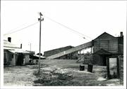
Industrial buildings with timber frames, clad in corrugated iron. The buildings have been on site since 1902, though the machinery has been upgraded several times, from steam power to gas to oil and finally to electricity.
Individual Building or Group
| Epoch | General | Specific |
|---|---|---|
| Present Use | MINING | Mining Battery |
| Original Use | MINING | Mining Battery |
| Type | General | Specific |
|---|---|---|
| Roof | METAL | Corrugated Iron |
| Wall | METAL | Corrugated Iron |
| General | Specific |
|---|---|
| OCCUPATIONS | Mining {incl. mineral processing} |
This information is provided voluntarily as a public service. The information provided is made available in good faith and is derived from sources believed to be reliable and accurate. However, the information is provided solely on the basis that readers will be responsible for making their own assessment of the matters discussed herein and are advised to verify all relevant representations, statements and information.
A representative industrial building form, housing an operation associated with goldmining and still in operation as a battery
The buildings are still the original ones, built in 1902. The machinery has been updated several times, converting from steam to gas to oil and then to electricity. The buildings are simple timber framed, corrugated iron lined industrial buildings designed for their particular functions; eg: stockpiles, crushing ore and extracting gold
Assessment 1976 Construction: 1902
This information is provided voluntarily as a public service. The information provided is made available in good faith and is derived from sources believed to be reliable and accurate. However, the information is provided solely on the basis that readers will be responsible for making their own assessment of the matters discussed herein and are advised to verify all relevant representations, statements and information.
Constructed from 1902
A representative industrial building form of historical significance, still performing the same gold extraction function for which it was built in 1902, and reflecting the mining history of Coolgardie.
The buildings are the original ones dating from 1902, comprising simple timber framed, corrugated iron lined industrial structures designed for their particular functions, ie stock pilling and crushing ore and extracting gold. The machinery has been updated several times, converting from steam to gas to oil and then to electricity.
One of a number of state built batteries and one of the few intact and remaining in operation.
High
Fair
| Ref ID No | Ref Name | Ref Source | Ref Date |
|---|---|---|---|
| National Trust Citation | |||
| Webb, M&A "The Centennial History of Kalgoorlie-Boulder" | 1993 |
| Owner | Category |
|---|---|
| I. Kean | Other Private |
This information is provided voluntarily as a public service. The information provided is made available in good faith and is derived from sources believed to be reliable and accurate. However, the information is provided solely on the basis that readers will be responsible for making their own assessment of the matters discussed herein and are advised to verify all relevant representations, statements and information.
Bayley St Coolgardie
Coolgardie
Goldfields
| Type | Status | Date | Documents |
|---|---|---|---|
| (no listings) |
| Type | Status | Date | Documents |
|---|---|---|---|
| (no listings) |
| Type | Status | Date | Grading/Management | |
|---|---|---|---|---|
| Category | ||||
| Classified by the National Trust | Classified | 27 Oct 1976 | ||
| Register of the National Estate | Permanent | 21 Mar 1978 | ||
00568 Warden's Court (fmr)
Individual Building or Group
| Epoch | General | Specific |
|---|---|---|
| Original Use | COMMERCIAL | Bank |
| Present Use | COMMERCIAL | Bank |
| General | Specific |
|---|---|
| OCCUPATIONS | Commercial & service industries |
This information is provided voluntarily as a public service. The information provided is made available in good faith and is derived from sources believed to be reliable and accurate. However, the information is provided solely on the basis that readers will be responsible for making their own assessment of the matters discussed herein and are advised to verify all relevant representations, statements and information.
Bayley St Coolgardie
Coolgardie
Goldfields
| Type | Status | Date | Documents |
|---|---|---|---|
| (no listings) |
| Type | Status | Date | Documents |
|---|---|---|---|
| (no listings) |
| Type | Status | Date | Grading/Management | |
|---|---|---|---|---|
| Category | ||||
| (no listings) | ||||
00568 Warden's Court (fmr)
Individual Building or Group
| Epoch | General | Specific |
|---|---|---|
| Original Use | MILITARY | Drill Hall |
| Present Use | MILITARY | Drill Hall |
This information is provided voluntarily as a public service. The information provided is made available in good faith and is derived from sources believed to be reliable and accurate. However, the information is provided solely on the basis that readers will be responsible for making their own assessment of the matters discussed herein and are advised to verify all relevant representations, statements and information.