Local Government
Coolgardie
Region
Goldfields
72B Bayley St Coolgardie
Coolgardie
Goldfields
Constructed from 1900
| Type | Status | Date | Documents |
|---|---|---|---|
| (no listings) |
| Type | Status | Date | Documents |
|---|---|---|---|
| (no listings) |
| Type | Status | Date | Grading/Management | |
|---|---|---|---|---|
| Category | ||||
| Municipal Inventory | Adopted | 27 Jul 1995 | Category 2 | |
Individual Building or Group
| Epoch | General | Specific |
|---|---|---|
| Original Use | COMMERCIAL | Shopping Complex |
| Present Use | COMMERCIAL | Shopping Complex |
| Type | General | Specific |
|---|---|---|
| Wall | TIMBER | Weatherboard |
| Wall | METAL | Corrugated Iron |
| General | Specific |
|---|---|
| OCCUPATIONS | Commercial & service industries |
This information is provided voluntarily as a public service. The information provided is made available in good faith and is derived from sources believed to be reliable and accurate. However, the information is provided solely on the basis that readers will be responsible for making their own assessment of the matters discussed herein and are advised to verify all relevant representations, statements and information.
Constructed from 1900
An important part of the central Bayley Street historic core.
Two of a row of four shops with deep verandahs and authentic shopfronts.
An important part of Bayley Street's commercial development.
High
Good
| Owner | Category |
|---|---|
| Shire of Coolgardie | Local Gov't |
This information is provided voluntarily as a public service. The information provided is made available in good faith and is derived from sources believed to be reliable and accurate. However, the information is provided solely on the basis that readers will be responsible for making their own assessment of the matters discussed herein and are advised to verify all relevant representations, statements and information.

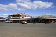
73 Bayley St Coolgardie
Coolgardie
Goldfields
Constructed from 1898
| Type | Status | Date | Documents |
|---|---|---|---|
| (no listings) |
| Type | Status | Date | Documents |
|---|---|---|---|
| (no listings) |
| Type | Status | Date | Grading/Management | |
|---|---|---|---|---|
| Category | ||||
| Municipal Inventory | Adopted | 27 Jul 1995 | Category 2 | |
| Statewide Hotel Survey | Completed | 01 Nov 1997 | ||
| Register of the National Estate | Permanent | 21 Mar 1978 | ||
| Classified by the National Trust | Classified | 06 Dec 1976 | ||
Individual Building or Group
| Epoch | General | Specific |
|---|---|---|
| Original Use | COMMERCIAL | Hotel, Tavern or Inn |
| Present Use | COMMERCIAL | Hotel, Tavern or Inn |
| Style |
|---|
| Federation Filigree |
| Type | General | Specific |
|---|---|---|
| Roof | METAL | Corrugated Iron |
| Wall | STONE | Local Stone |
| General | Specific |
|---|---|
| OCCUPATIONS | Hospitality industry & tourism |
This information is provided voluntarily as a public service. The information provided is made available in good faith and is derived from sources believed to be reliable and accurate. However, the information is provided solely on the basis that readers will be responsible for making their own assessment of the matters discussed herein and are advised to verify all relevant representations, statements and information.
Constructed from 1898
Architecturally significant as a surviving, defining element in the streetscape and the Bayley Street precinct; close to its original character.
A two storied stone building with a two storied wide verandah and corrugated iron roof, still fully operative as an hotel and representative in design and materials of the corner pub of the late 1890s with evidence of many adaptions and alterations to original building fabric through time.
This is the third hotel built on this site, the first two were destroyed by fire. It is now the only remaining licensed hotel in this town which boasted 26 at its peak, 16 of these in Bayley Street. The original hotels on this site were single storey and the last built had the second floor added at a later date in about the 1930s.
Moderate-High
Good
| Ref ID No | Ref Name | Ref Source | Ref Date |
|---|---|---|---|
| Webb, M&A "The Centennial History of Kalgoorlie-Boulder" | 1993 |
| Owner | Category |
|---|---|
| E. Gianni | Other Private |
This information is provided voluntarily as a public service. The information provided is made available in good faith and is derived from sources believed to be reliable and accurate. However, the information is provided solely on the basis that readers will be responsible for making their own assessment of the matters discussed herein and are advised to verify all relevant representations, statements and information.
Architecturally significant as a surviving element in the streetscape and the Bayley St precinct close to its original character.
A two storied stone building with two storied verandah and CGI roof, still fully operative as hotel (1976) and representative in design and materials of the corner pub of the late 1890's. 1897/98 after the 1897 fire.
Assessment 1976
This information is provided voluntarily as a public service. The information provided is made available in good faith and is derived from sources believed to be reliable and accurate. However, the information is provided solely on the basis that readers will be responsible for making their own assessment of the matters discussed herein and are advised to verify all relevant representations, statements and information.
75-77 Bayley St Coolgardie
Ghost Inn Hotel, Michelle Lodge
Gold Rush Lodge, Railway Lodge
Coolgardie
Goldfields
Constructed from 1896 to 1990
| Type | Status | Date | Documents |
|---|---|---|---|
| State Register | Registered | 27 Dec 2002 | HCWebsite.Listing+ListingDocument, HCWebsite.Listing+ListingDocument |
| Type | Status | Date | Documents |
|---|---|---|---|
| (no listings) |
| Type | Status | Date | Grading/Management | |
|---|---|---|---|---|
| Category | ||||
| Municipal Inventory | Adopted | 27 Jul 1995 | Category 1 | |
| Register of the National Estate | Permanent | 21 Mar 1978 | ||
| Statewide Hotel Survey | Completed | 01 Nov 1997 | ||
| Classified by the National Trust | Classified | 27 Oct 1976 | ||
| Library Id | Title | Medium | Year Of Publication |
|---|---|---|---|
| 7310 | Railway Hotel, Coolgardie, Western Australia : conservation works (Final report). | Conservation works report | 2005 |
| 8779 | Railway Hotel, (fmr) | Conservation works report | 2007 |
| 8774 | Railway Hotel, Coolgardie; Western Australia. | Report | 2007 |
| 4813 | Railway Hotel (former), Coolgardie : conservation plan. | Heritage Study {Cons'n Plan} | 2000 |
| 9216 | Railway Hotel, (Fmr) Coolgardie, Western Australia. Final report - Heritage Council Grants Program 2007/08 Grant: 1/642 Job No:07154 | Conservation works report | 2009 |
Individual Building or Group
| Epoch | General | Specific |
|---|---|---|
| Original Use | COMMERCIAL | Office or Administration Bldg |
| Other Use | COMMERCIAL | Hotel, Tavern or Inn |
| Present Use | RESIDENTIAL | Institutional Housing |
| Style |
|---|
| Federation Filigree |
| Federation Free Classical |
| Type | General | Specific |
|---|---|---|
| Other | TIMBER | Other Timber |
| Roof | METAL | Corrugated Iron |
| Wall | BRICK | Other Brick |
| General | Specific |
|---|---|
| OCCUPATIONS | Hospitality industry & tourism |
This information is provided voluntarily as a public service. The information provided is made available in good faith and is derived from sources believed to be reliable and accurate. However, the information is provided solely on the basis that readers will be responsible for making their own assessment of the matters discussed herein and are advised to verify all relevant representations, statements and information.
Constructed from 1898
Architecturally significant as a surviving element, close to its original character, in the Bayley Street streetscape. Important in the definition of the historic Bayley Street precinct.
A simple two storied brick corner hotel with a two storeyed verandah and corrugated iron roof, originally built as a bonded store and later converted and extended as an hotel. The exterior is fairly authentic but the interior has been compromised by a series of alterations and additions and the removal of the bars. The hotel was de-licenced in the 1960s.
A representative type of hotel in a relatively unchanged state from the main period of Coolgardie's development when 26 hotels operated in the town.
Moderate-High
Fair
| Ref ID No | Ref Name | Ref Source | Ref Date |
|---|---|---|---|
| Webb, M&A "The Centennial History of Kalgoorlie-Boulder" | 1993 |
| Owner | Category |
|---|---|
| M&J Charlton | Other Private |
This information is provided voluntarily as a public service. The information provided is made available in good faith and is derived from sources believed to be reliable and accurate. However, the information is provided solely on the basis that readers will be responsible for making their own assessment of the matters discussed herein and are advised to verify all relevant representations, statements and information.

76 Bayley St Coolgardie
Cnr Lefroy St
Roads Board Office
Coolgardie
Goldfields
Constructed from 1903
| Type | Status | Date | Documents |
|---|---|---|---|
| (no listings) |
| Type | Status | Date | Documents |
|---|---|---|---|
| (no listings) |
| Type | Status | Date | Grading/Management | |
|---|---|---|---|---|
| Category | ||||
| Register of the National Estate | Permanent | 21 Mar 1978 | ||
| Classified by the National Trust | Classified | 27 Oct 1976 | ||
| Municipal Inventory | Adopted | 27 Jul 1995 | Category 2 | |
Individual Building or Group
| Epoch | General | Specific |
|---|---|---|
| Present Use | GOVERNMENTAL | Town, Shire or District Hall |
| Other Use | HEALTH | Other |
| Original Use | Transport\Communications | Road: Office or Administration Bldg |
| Type | General | Specific |
|---|---|---|
| Wall | BRICK | Common Brick |
| General | Specific |
|---|---|
| SOCIAL & CIVIC ACTIVITIES | Government & politics |
This information is provided voluntarily as a public service. The information provided is made available in good faith and is derived from sources believed to be reliable and accurate. However, the information is provided solely on the basis that readers will be responsible for making their own assessment of the matters discussed herein and are advised to verify all relevant representations, statements and information.
A characteristic building type, still in use, with Historic and social associations with the establishment of the town and its early administration.
Town Hall and municipal chambers were built with a 'respectable' neo-classic brick facade, however behind this the building is a simple timber framed structure, clad in galvanized iron. The proposal to replace thi building with a town hall as grand and opulent as those at Ballorat & Bendigo never came to fruition.
Assessment 1976
This information is provided voluntarily as a public service. The information provided is made available in good faith and is derived from sources believed to be reliable and accurate. However, the information is provided solely on the basis that readers will be responsible for making their own assessment of the matters discussed herein and are advised to verify all relevant representations, statements and information.
Constructed from 1903
A modest example of a characteristic building type, still in use, with historical and civic aspirations. Demonstrates the establishment of the town and its early administration. A critical element in the streetscape of the Bayley Street Precinct.
The original town hall and road board office built in the 1890's with a respectable 2 room deep brick facade and characteristic timber-framed, corrugated iron clad structure behind. The brick part of the building employs classical motifs and has stucco strings, pilasters and pediments. A later classically derived entrance portico to the offices.
The place represents the earliest remaining evidence of accommodation for the local government. It also served as the meeting place of the Mechanics Institute. It also served as a cinema and had a picture garden on the eastern side. The latter's projection room is still intact.
High
Good
| Ref ID No | Ref Name | Ref Source | Ref Date |
|---|---|---|---|
| Webb, M&A "The Centennial History of Kalgoorlie-Boulder" |
| Owner | Category |
|---|---|
| Shire of Coolgardie | Local Gov't |
This information is provided voluntarily as a public service. The information provided is made available in good faith and is derived from sources believed to be reliable and accurate. However, the information is provided solely on the basis that readers will be responsible for making their own assessment of the matters discussed herein and are advised to verify all relevant representations, statements and information.
77 Bayley St Coolgardie
Coolgardie
Goldfields
Constructed from 1900
| Type | Status | Date | Documents |
|---|---|---|---|
| (no listings) |
| Type | Status | Date | Documents |
|---|---|---|---|
| (no listings) |
| Type | Status | Date | Grading/Management | |
|---|---|---|---|---|
| Category | ||||
| Classified by the National Trust | Classified | 27 Oct 1976 | ||
| Register of the National Estate | Registered | 21 Mar 1978 | ||
| Municipal Inventory | Adopted | 27 Jul 1995 | Category 2 | |
00570 Railway Hotel (fmr), Coolgardie
Individual Building or Group
| Epoch | General | Specific |
|---|---|---|
| Present Use | COMMERCIAL | Office or Administration Bldg |
| Original Use | COMMERCIAL | Shopping Complex |
| General | Specific |
|---|---|
| OCCUPATIONS | Commercial & service industries |
This information is provided voluntarily as a public service. The information provided is made available in good faith and is derived from sources believed to be reliable and accurate. However, the information is provided solely on the basis that readers will be responsible for making their own assessment of the matters discussed herein and are advised to verify all relevant representations, statements and information.
A significant part of the Bayley Street precinct. A minor but important surviving part of Bayley Street's 19th Century streetscape illustrating its small scale, lightly constructed commercial nature.
A group of 4 places with shop front windows and a verandah over the footpath constructed from tiber framing. One has an original sign stating "Billiards" hanging from under the verandah. Part of the eastern end of the structure was built from brick and formed part of the neighbouring hotel.
Part of the late 19th Century main street development terminating the western edge of the commercial centre.
Moderate-High
Fair
| Owner | Category |
|---|---|
| M&J Charlton | Other Private |
This information is provided voluntarily as a public service. The information provided is made available in good faith and is derived from sources believed to be reliable and accurate. However, the information is provided solely on the basis that readers will be responsible for making their own assessment of the matters discussed herein and are advised to verify all relevant representations, statements and information.
83 Bayley St Coolgardie
Coolgardie
Goldfields
Constructed from 1900
| Type | Status | Date | Documents |
|---|---|---|---|
| (no listings) |
| Type | Status | Date | Documents |
|---|---|---|---|
| (no listings) |
| Type | Status | Date | Grading/Management | |
|---|---|---|---|---|
| Category | ||||
| Municipal Inventory | Adopted | 27 Jul 1995 | Category 2 | |
Individual Building or Group
| Epoch | General | Specific |
|---|---|---|
| Original Use | RESIDENTIAL | Single storey residence |
| Present Use | RESIDENTIAL | Single storey residence |
| Type | General | Specific |
|---|---|---|
| Wall | TIMBER | Weatherboard |
| Roof | METAL | Corrugated Iron |
| General | Specific |
|---|---|
| DEMOGRAPHIC SETTLEMENT & MOBILITY | Settlements |
This information is provided voluntarily as a public service. The information provided is made available in good faith and is derived from sources believed to be reliable and accurate. However, the information is provided solely on the basis that readers will be responsible for making their own assessment of the matters discussed herein and are advised to verify all relevant representations, statements and information.
Constructed from 1900
An unexceptional typical house important for the way in which it contributes to the overall streetscape of Bayley Street.
An expansive hipped roof with a broken back roof over the verandah that encircles most of the house is a strong feature. Part of the verandahs have been filled in.
A moderately important representative house.
Moderate-High
Fair
| Owner | Category |
|---|---|
| B. Baker | Other Private |
This information is provided voluntarily as a public service. The information provided is made available in good faith and is derived from sources believed to be reliable and accurate. However, the information is provided solely on the basis that readers will be responsible for making their own assessment of the matters discussed herein and are advised to verify all relevant representations, statements and information.
85 Bayley St Coolgardie
Pensioners League
United Club Hotel (site of)
Coolgardie
Goldfields
Constructed from 1920
| Type | Status | Date | Documents |
|---|---|---|---|
| (no listings) |
| Type | Status | Date | Documents |
|---|---|---|---|
| (no listings) |
| Type | Status | Date | Grading/Management | |
|---|---|---|---|---|
| Category | ||||
| Municipal Inventory | Adopted | 27 Jul 1995 | Category 2 | |
Individual Building or Group
| Epoch | General | Specific |
|---|---|---|
| Present Use | SOCIAL\RECREATIONAL | Other |
| Original Use | SOCIAL\RECREATIONAL | CWA Hall |
| Type | General | Specific |
|---|---|---|
| Wall | ASBESTOS | Fibrous Cement, flat |
| General | Specific |
|---|---|
| SOCIAL & CIVIC ACTIVITIES | Institutions |
This information is provided voluntarily as a public service. The information provided is made available in good faith and is derived from sources believed to be reliable and accurate. However, the information is provided solely on the basis that readers will be responsible for making their own assessment of the matters discussed herein and are advised to verify all relevant representations, statements and information.
Constructed from 1920
An important site now marked by a modest building that makes a positive contribution to Bayley Street.
A former CWA building it is a simple structure set in the centre of its site and with its neat appearance contributes to Bayley Street as part of the overall streetscape.
Set on the site of Coolgardie's most westerly hotel, the United Club Hotel, the CWA accommodation was constructed there in its wake.
High
Good
| Owner | Category |
|---|---|
| Australian Pensioners League of WA Inc | Other Private |
This information is provided voluntarily as a public service. The information provided is made available in good faith and is derived from sources believed to be reliable and accurate. However, the information is provided solely on the basis that readers will be responsible for making their own assessment of the matters discussed herein and are advised to verify all relevant representations, statements and information.
9-17 Bayley St Coolgardie
Coolgardie
Goldfields
Constructed from 1899
| Type | Status | Date | Documents |
|---|---|---|---|
| (no listings) |
| Type | Status | Date | Documents |
|---|---|---|---|
| (no listings) |
| Type | Status | Date | Grading/Management | |
|---|---|---|---|---|
| Category | ||||
| Municipal Inventory | Adopted | 27 Jul 1995 | Category 3 | |
| Classified by the National Trust | Classified | 27 Oct 1976 | ||
| Register of the National Estate | Nominated | 16 Dec 1976 | ||
| Register of the National Estate | Registered | 21 Mar 1978 | ||
| Name | Type | Year From | Year To |
|---|---|---|---|
| Edwin Summerhayes | Architect | - | - |
Historic site
| Epoch | General | Specific |
|---|---|---|
| Present Use | EDUCATIONAL | Technical School |
| Original Use | EDUCATIONAL | Technical School |
| General | Specific |
|---|---|
| SOCIAL & CIVIC ACTIVITIES | Education & science |
This information is provided voluntarily as a public service. The information provided is made available in good faith and is derived from sources believed to be reliable and accurate. However, the information is provided solely on the basis that readers will be responsible for making their own assessment of the matters discussed herein and are advised to verify all relevant representations, statements and information.
Constructed from 1899
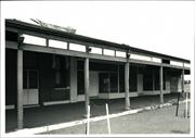
These ruins are significant due to their industrial, archaeological, historical and social significance and in that they are associated withthe first school of mines.
The site contains a small number of arhcaeological remains of the large structure of stone, timber frame construction and iron that once stood on the site. The photograph above is contemporaneous and shows the building as it stood in about 1900.
The building was erected for the Coolgardie International Mining and Industrial Exhibition in 1899. The School of Mines was established in it in 1903 before being transferred to Kalgoorlie the following year. The bulk of the building burnt down in 1929 and the corrugated iron wings were moved to Perth as the first building of the W.A. University in Irwin Street.
Moderate
Poor
| Ref ID No | Ref Name | Ref Source | Ref Date |
|---|---|---|---|
| Webb, M & A "The Centennial History of Kalgoorlie-Boulder" | 1993 |
| Owner | Category |
|---|---|
| Shire of Coolgardie | Local Gov't |
This information is provided voluntarily as a public service. The information provided is made available in good faith and is derived from sources believed to be reliable and accurate. However, the information is provided solely on the basis that readers will be responsible for making their own assessment of the matters discussed herein and are advised to verify all relevant representations, statements and information.
Historic associations with the boom period of Coolgardie. The building was erected for the International Mining and Industrial Exhibition 1899. The school of mines established in 1902 before being transferred to Kalgoorlie in the following ear the corrugated iron wings were later moved to Perth as the first buildings of the University of WA in Irwin St.
The site of the special building constructed around 1898/99 to house the Coolgardie International Mining and Industrial Exhibition which attracted over 60,000 people including from overseas. The building was later used as a School of Mines until 1917. The timber framed CGI wings were moved to Perth to become the first University of WA. It was destroyed by fire around 1930. The local authority intends to expose the remaining base of the walls and to re-erect parts of the corner portico as n exercise in upgrading the visual historic value of the site.
Assessment 1976
This information is provided voluntarily as a public service. The information provided is made available in good faith and is derived from sources believed to be reliable and accurate. However, the information is provided solely on the basis that readers will be responsible for making their own assessment of the matters discussed herein and are advised to verify all relevant representations, statements and information.
97 Bayley St Coolgardie
Coolgardie
Goldfields
Constructed from 1890
| Type | Status | Date | Documents |
|---|---|---|---|
| (no listings) |
| Type | Status | Date | Documents |
|---|---|---|---|
| (no listings) |
| Type | Status | Date | Grading/Management | |
|---|---|---|---|---|
| Category | ||||
| Municipal Inventory | Adopted | 27 Jul 1995 | Category 2 | |
| Classified by the National Trust | Recorded | 27 Oct 1976 | ||
| Register of the National Estate | Registered | 21 Mar 1978 | ||
Individual Building or Group
| Epoch | General | Specific |
|---|---|---|
| Present Use | RESIDENTIAL | Single storey residence |
| Original Use | RESIDENTIAL | Single storey residence |
| Type | General | Specific |
|---|---|---|
| Wall | METAL | Other Metal |
| Wall | ASBESTOS | Fibrous Cement, flat |
| Roof | METAL | Corrugated Iron |
| General | Specific |
|---|---|
| DEMOGRAPHIC SETTLEMENT & MOBILITY | Settlements |
This information is provided voluntarily as a public service. The information provided is made available in good faith and is derived from sources believed to be reliable and accurate. However, the information is provided solely on the basis that readers will be responsible for making their own assessment of the matters discussed herein and are advised to verify all relevant representations, statements and information.
Constructed from 1890
A minor cottage that contributes positively to the character of Bayley Street.
A small timber framed cottage with a gabled roof and timber joinery, iron clad walls and iron chimney flutes. It has a simply framed verandah.
Probably constructed in the late 1890's
High
Fair
| Owner | Category |
|---|---|
| G Amy | Other Private |
This information is provided voluntarily as a public service. The information provided is made available in good faith and is derived from sources believed to be reliable and accurate. However, the information is provided solely on the basis that readers will be responsible for making their own assessment of the matters discussed herein and are advised to verify all relevant representations, statements and information.
Bayley/Sylvester/Wilson Sts Coolgardie
Coolgardie
Goldfields
Constructed from 1897
| Type | Status | Date | Documents |
|---|---|---|---|
| (no listings) |
| Type | Status | Date | Documents |
|---|---|---|---|
| (no listings) |
| Type | Status | Date | Grading/Management | |
|---|---|---|---|---|
| Category | ||||
| Municipal Inventory | Adopted | 27 Jul 1995 | Category 2 | |
| Register of the National Estate | Permanent | 21 Mar 1978 | ||
Urban Park
| Epoch | General | Specific |
|---|---|---|
| Present Use | PARK\RESERVE | Park\Reserve |
| Original Use | PARK\RESERVE | Park\Reserve |
| General | Specific |
|---|---|
| SOCIAL & CIVIC ACTIVITIES | Sport, recreation & entertainment |
This information is provided voluntarily as a public service. The information provided is made available in good faith and is derived from sources believed to be reliable and accurate. However, the information is provided solely on the basis that readers will be responsible for making their own assessment of the matters discussed herein and are advised to verify all relevant representations, statements and information.
A place laid down i the 1897 townsite plan as parklands, to be a place of public pleasure, and maintained and used for that purpose today.
grassed and treed public space in the centre of the town, still used and well maintained. A critical place in the rigorous climate of the goldfields district
Assessment 1976 A.
This information is provided voluntarily as a public service. The information provided is made available in good faith and is derived from sources believed to be reliable and accurate. However, the information is provided solely on the basis that readers will be responsible for making their own assessment of the matters discussed herein and are advised to verify all relevant representations, statements and information.
Constructed from 1897
Important as a focus for leisure, relaxation and tourism, and as a symbol of civic pride.
A grassed and treed public place in the centre of the town, bounded by Bayley, Sylvester and Wilson Streets. Still used and well maintained. A critical place in the rigorous climate of the goldfields. The park is a perennial green oasis.
A park laid down in the 1897 townsite plan as parklands, to be used as a place of public pleasure and has been maintained for that purpose to the present day. Also the site of the first inland swimming pool in the southern hemisphere.
High
Good
| Ref ID No | Ref Name | Ref Source | Ref Date |
|---|---|---|---|
| Webb, M&A "The Centennial History of Kalgoorlie-Boulder" | 1993 |
| Owner | Category |
|---|---|
| Shire of Coolgardie | Local Gov't |
This information is provided voluntarily as a public service. The information provided is made available in good faith and is derived from sources believed to be reliable and accurate. However, the information is provided solely on the basis that readers will be responsible for making their own assessment of the matters discussed herein and are advised to verify all relevant representations, statements and information.
Burra Rock Rd Coolgardie
The majority of remnants seem to be in the Burra rock vicinity along Burra Rock Road and Bulong area.
Coolgardie
Goldfields
Constructed from 1890
| Type | Status | Date | Documents |
|---|---|---|---|
| (no listings) |
| Type | Status | Date | Documents |
|---|---|---|---|
| RHP - To be assessed | Current | 29 Jul 2005 |
| Type | Status | Date | Grading/Management | |
|---|---|---|---|---|
| Category | ||||
| Municipal Inventory | Adopted | 27 Jul 1995 | Category 3 | |
| Mining Heritage Study | Completed | 30 Jun 1999 | ||
The place is associated with the gold rush in the Goldfields as it was used to source timber to fuel the industrial components of the gold mining industry as well as small commercial enterprises and domestic wood consumption.
The place is rare as a visable woodline track in Wester Australia associated with the Gold Mining Industry.
The place is representative and a good example of the woodlines that existed throughout the goldfields.
The place represents an industry comprising a large proportion of immigrant workers from the Southern and Eastern Europe.
The place is representative of a way of life no longer practised.
□ Distinct raised path through the bush. □ The compacted ground has prevented the return of plants once use stopped thus preserving the tracks for clear viewing. □ It is impossible to determine a curtilage to any chosen site at this time. Extensive time is required in the area with an experienced local guide with a 4WD. □ The actual tramline construction has been removed. The formations through the bush remain.
Wood was needed in the early 1900s in Coolgardie and Kalgoorlie to support machinery for mining as well as for private domestic use. More and more firewood were needed as the population rapidly increased in response to the gold rush experienced at the time. The stocks of wood around Kalgoorlie were rapidly depleted and woodcutters began to move further afield. Entrepreneurs such as W.N. Hedges devises a solution to these problems – a railway line ‘Woodline’ along which private trains operated transferring wood long distances into Coolgardie and Kalgoorlie. Woodcutters who provided wood for these trains often lived in remote locations, leaving wood at the side of the rail to be collected. They lived in rustic conditions. They were also considered to be of a lower class than the miners. Relics from the woodcutters' camps can be seen along some of the tracks. The Woodlines were narrow gauge railway lines used to haul timber into Kalgoorlie-Boulder for the mines and fuel for industry. They were developed around 1900 following the discovery of gold in Coolgardie in 1892 and in Kalgoorlie the following year and operated until the 1960s. There have been reports from four-wheel drive users that use the tracks still contain many of the original railway elements remain such as loading ramps, landings, rubbish pits and camp remnants scattered in the vicinity of Burra Rock Road. Timber cut from the arid inland forests and woodlands was also used as fuel in the pumping stations along the Goldfields water pipeline between Mundaring and Kalgoorlie, completed in 1903. The last of the wood-fired boilers and pumping stations converted to diesel in 1960. By 1965 the Goldfields Woodlines and timber-fueled pump stations had been consigned to history. This Woodline is significant in that they are rarely found in such a good condition. The Shire of Coolgardie is in the preliminary stages of developing an interpretation centre based on the woodlines in the region.
Moderate
Good
| Library Id | Title | Medium | Year Of Publication |
|---|---|---|---|
| 6755 | Timber for gold : life on the goldfields woodlines. | Book | 2002 |
Historic Site
| Epoch | General | Specific |
|---|---|---|
| Present Use | SOCIAL\RECREATIONAL | Other |
| Original Use | FORESTRY | Other |
| Present Use | VACANT\UNUSED | Vacant\Unused |
| Style |
|---|
| Vernacular |
| General | Specific |
|---|---|
| OCCUPATIONS | Timber industry |
| TRANSPORT & COMMUNICATIONS | Rail & light rail transport |
This information is provided voluntarily as a public service. The information provided is made available in good faith and is derived from sources believed to be reliable and accurate. However, the information is provided solely on the basis that readers will be responsible for making their own assessment of the matters discussed herein and are advised to verify all relevant representations, statements and information.
Constructed from 1926
This woodline is significant in that they are rarely found in such good condition with most facets of early timber harvesting present, so close to the Coolgardie / Kalgoorlie area. The 39kms of line also covers a good area of typical goldfields vegetation types and is an excellent scenic route to travel between Cave Hill and Burra Rock.
A classic example of a 1930s woodline. This woodline stretches for 39kms and has a loading ramp, holding yards, landings and associated camps and rubbish pits scattered along the line.
Woodlines were rail tracks laid extending out from Coolgardie and Kalgorlie into the surrounding woodland to collect fuel for domestic and industrial consumption.
High
Fair-Poor
| Ref ID No | Ref Name | Ref Source | Ref Date |
|---|---|---|---|
| Webb, M&A "The Centennial History of Kalgoorlie-Boulder" | 1993 |
| Owner | Category |
|---|---|
| Vacant Crown Land | Commonwealth Gov't |
This information is provided voluntarily as a public service. The information provided is made available in good faith and is derived from sources believed to be reliable and accurate. However, the information is provided solely on the basis that readers will be responsible for making their own assessment of the matters discussed herein and are advised to verify all relevant representations, statements and information.
Coolgardie Esperance Hwy Coolgardie
Wongi Reserve No. 2955
Coolgardie
Goldfields
Constructed from 1866
| Type | Status | Date | Documents |
|---|---|---|---|
| (no listings) |
| Type | Status | Date | Documents |
|---|---|---|---|
| (no listings) |
| Type | Status | Date | Grading/Management | |
|---|---|---|---|---|
| Category | ||||
| Wells of Explorer Charles Hunt Survey | Recorded | 01 Nov 1991 | ||
24806 Hunt's Wells Group
Other Built Type
| Epoch | General | Specific |
|---|---|---|
| Original Use | GOVERNMENTAL | Other |
| Original Use | GOVERNMENTAL | Reservoir or Dam |
| Type | General | Specific |
|---|---|---|
| Wall | STONE | Granite |
| General | Specific |
|---|---|
| DEMOGRAPHIC SETTLEMENT & MOBILITY | Exploration & surveying |
| DEMOGRAPHIC SETTLEMENT & MOBILITY | Settlements |
| SOCIAL & CIVIC ACTIVITIES | Community services & utilities |
| DEMOGRAPHIC SETTLEMENT & MOBILITY | Aboriginal Occupation |
This information is provided voluntarily as a public service. The information provided is made available in good faith and is derived from sources believed to be reliable and accurate. However, the information is provided solely on the basis that readers will be responsible for making their own assessment of the matters discussed herein and are advised to verify all relevant representations, statements and information.
Coolgardie Esperence Hwy Coolgardie
Coolgardie
Goldfields
Constructed from 1905
| Type | Status | Date | Documents |
|---|---|---|---|
| (no listings) |
| Type | Status | Date | Documents |
|---|---|---|---|
| (no listings) |
| Type | Status | Date | Grading/Management | |
|---|---|---|---|---|
| Category | ||||
| Municipal Inventory | Adopted | 27 Jul 1995 | Category 4 | |
Historic Town or district
| Epoch | General | Specific |
|---|---|---|
| Present Use | VACANT\UNUSED | Vacant\Unused |
| Original Use | MINING | Other |
| General | Specific |
|---|---|
| DEMOGRAPHIC SETTLEMENT & MOBILITY | Resource exploitation & depletion |
This information is provided voluntarily as a public service. The information provided is made available in good faith and is derived from sources believed to be reliable and accurate. However, the information is provided solely on the basis that readers will be responsible for making their own assessment of the matters discussed herein and are advised to verify all relevant representations, statements and information.
Constructed from 1905
An important site worth marking.
Site of the Two Boys mine and the discovery by Paddy Higgins. An integral part of the goldfields story; a brief success followed by disappointment and extinction. The Two Boys mine has been re-activated by Samantha Gold NL.
| Ref ID No | Ref Name | Ref Source | Ref Date |
|---|---|---|---|
| Webb, M&A "The Centennial History of Kalgoorlie-Boulder" | 1993 |
This information is provided voluntarily as a public service. The information provided is made available in good faith and is derived from sources believed to be reliable and accurate. However, the information is provided solely on the basis that readers will be responsible for making their own assessment of the matters discussed herein and are advised to verify all relevant representations, statements and information.
Coolgardie North Rd Coolgardie
Bonnie Vale
Coolgardie
Goldfields
Constructed from 1897
| Type | Status | Date | Documents |
|---|---|---|---|
| (no listings) |
| Type | Status | Date | Documents |
|---|---|---|---|
| (no listings) |
| Type | Status | Date | Grading/Management | |
|---|---|---|---|---|
| Category | ||||
| Municipal Inventory | Adopted | 27 Jul 1995 | Category 5 | |
Historic Town or district
| Epoch | General | Specific |
|---|---|---|
| Original Use | MINING | Housing or Quarters |
| Present Use | MINING | Housing or Quarters |
| General | Specific |
|---|---|
| PEOPLE | Famous & infamous people |
| DEMOGRAPHIC SETTLEMENT & MOBILITY | Resource exploitation & depletion |
This information is provided voluntarily as a public service. The information provided is made available in good faith and is derived from sources believed to be reliable and accurate. However, the information is provided solely on the basis that readers will be responsible for making their own assessment of the matters discussed herein and are advised to verify all relevant representations, statements and information.
Constructed from 1897
Impotant as a mining site but probably more important for the assocaite tale of determination and heroism associated with the Varischetti rescue.
An important mining town site made more important by the story of the Varischetti rescue after a 10 day ordeal underground. He was rescued by his workmates and Hughes and Heame are particularly important figures in the successful rescue bid.
| Ref ID No | Ref Name | Ref Source | Ref Date |
|---|---|---|---|
| Webb, M&A "The Centennial History of Kalgoorlie-Boulder" | 1993 |
This information is provided voluntarily as a public service. The information provided is made available in good faith and is derived from sources believed to be reliable and accurate. However, the information is provided solely on the basis that readers will be responsible for making their own assessment of the matters discussed herein and are advised to verify all relevant representations, statements and information.
Coolgardie North Rd Coolgardie
Coolgardie
Goldfields
Constructed from 1897
| Type | Status | Date | Documents |
|---|---|---|---|
| (no listings) |
| Type | Status | Date | Documents |
|---|---|---|---|
| (no listings) |
| Type | Status | Date | Grading/Management | |
|---|---|---|---|---|
| Category | ||||
| Municipal Inventory | Adopted | 27 Jul 1995 | Category 4 | |
Historic Town or district
| Epoch | General | Specific |
|---|---|---|
| Original Use | MINING | Other |
| Present Use | VACANT\UNUSED | Vacant\Unused |
| General | Specific |
|---|---|
| DEMOGRAPHIC SETTLEMENT & MOBILITY | Resource exploitation & depletion |
This information is provided voluntarily as a public service. The information provided is made available in good faith and is derived from sources believed to be reliable and accurate. However, the information is provided solely on the basis that readers will be responsible for making their own assessment of the matters discussed herein and are advised to verify all relevant representations, statements and information.
Constructed from 1897
An important site worth marking.
Kintore was famous for the alluvium found in 'cement', a conglomerate material of detritus held together with calcium or silcerous material. Gold had been discovered in Kintore in 1895. An integral part of the goldfields story; brief success followed by disappointment and extinction.
| Ref ID No | Ref Name | Ref Source | Ref Date |
|---|---|---|---|
| Webb, M&A "The Centennial History of Kalgoorlie-Boulder" | 1993 |
This information is provided voluntarily as a public service. The information provided is made available in good faith and is derived from sources believed to be reliable and accurate. However, the information is provided solely on the basis that readers will be responsible for making their own assessment of the matters discussed herein and are advised to verify all relevant representations, statements and information.
Lot 101 Coolgardie-Esperance Hwy Coolgardie
2.5 miles north, north-west of Depot Hill and about 120 meters (6 chains) from the Southern Base of Horse Rock.
Coolgardie
Goldfields
Constructed from 1866 to 1906
| Type | Status | Date | Documents |
|---|---|---|---|
| (no listings) |
| Type | Status | Date | Documents |
|---|---|---|---|
| (no listings) |
| Type | Status | Date | Grading/Management | |
|---|---|---|---|---|
| Category | ||||
| Wells of Explorer Charles Hunt Survey | Recorded | 01 Nov 1991 | ||
24806 Hunt's Wells Group
Other Built Type
| Epoch | General | Specific |
|---|---|---|
| Original Use | GOVERNMENTAL | Other |
| Type | General | Specific |
|---|---|---|
| Wall | STONE | Granite |
| General | Specific |
|---|---|
| DEMOGRAPHIC SETTLEMENT & MOBILITY | Exploration & surveying |
| DEMOGRAPHIC SETTLEMENT & MOBILITY | Aboriginal Occupation |
| DEMOGRAPHIC SETTLEMENT & MOBILITY | Settlements |
| SOCIAL & CIVIC ACTIVITIES | Community services & utilities |
This information is provided voluntarily as a public service. The information provided is made available in good faith and is derived from sources believed to be reliable and accurate. However, the information is provided solely on the basis that readers will be responsible for making their own assessment of the matters discussed herein and are advised to verify all relevant representations, statements and information.
Forrest St Coolgardie
Coolgardie
Goldfields
Constructed from 1890 to 1894
| Type | Status | Date | Documents |
|---|---|---|---|
| State Register | Registered | 20 Aug 1993 | HCWebsite.Listing+ListingDocument |
| Type | Status | Date | Documents |
|---|---|---|---|
| (no listings) |
| Type | Status | Date | Grading/Management | |
|---|---|---|---|---|
| Category | ||||
| Municipal Inventory | Adopted | 27 Jul 1995 | Category 1 | |
| Register of the National Estate | Permanent | 21 Mar 1978 | ||
| Classified by the National Trust | Classified | 06 Dec 1976 | ||
The register entry includes two intact headstones, other stone grave markers, and a memorial, and the land on which they stand being Reserve 6441.
Other Built Type
| Epoch | General | Specific |
|---|---|---|
| Original Use | MONUMENT\CEMETERY | Cemetery |
| Present Use | VACANT\UNUSED | Vacant\Unused |
| General | Specific |
|---|---|
| DEMOGRAPHIC SETTLEMENT & MOBILITY | Settlements |
This information is provided voluntarily as a public service. The information provided is made available in good faith and is derived from sources believed to be reliable and accurate. However, the information is provided solely on the basis that readers will be responsible for making their own assessment of the matters discussed herein and are advised to verify all relevant representations, statements and information.
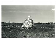
Historical and social associations with the first settlers of the district.
The cemetery is a fenced area of land, approximately 50m by 50m. It contains two graves which are intact and several piles of stones marking locations of other graves. There is also a memorial to the early pioneers.
Assessment 1976: Site and intant headstones and railings The first burial ground in Coolgardie, containing the graves of the first 32 burials, the most notable of which is the grave of Holland, the renowned discoverer of underground water sources and trail blazer in the early days of the district.
This information is provided voluntarily as a public service. The information provided is made available in good faith and is derived from sources believed to be reliable and accurate. However, the information is provided solely on the basis that readers will be responsible for making their own assessment of the matters discussed herein and are advised to verify all relevant representations, statements and information.
Constructed from 1890
As Coolgardie's first burial ground, the cemetery is significant for its historical link with the early history of the town and important figures in the town's development.
The cemetery is a fenced off area of land, approximately 50m x 50m. It contains two graves which are intact, and several piles of stones marking the location of other graves. There is also a memorial to the early pioneers. This was the first burial ground in Coolgardie, containing the graves of the first 32 burials, the most notable of which is the grave of Walsh, the noted discoverer of the underground water source and early explorer.
The first cemetery in Coolgardie, later abandoned as being too close to the rapidly expanding town in 1894.
Moderate
Fair
| Ref ID No | Ref Name | Ref Source | Ref Date |
|---|---|---|---|
| Webb, M&A "The Centennial History of Kalgoorlie-Boulder" | 1993 |
| Owner | Category |
|---|---|
| Shire of Coolgardie | Local Gov't |
This information is provided voluntarily as a public service. The information provided is made available in good faith and is derived from sources believed to be reliable and accurate. However, the information is provided solely on the basis that readers will be responsible for making their own assessment of the matters discussed herein and are advised to verify all relevant representations, statements and information.
3 Forrest St Coolgardie
Coolgardie
Goldfields
Constructed from 1890
| Type | Status | Date | Documents |
|---|---|---|---|
| (no listings) |
| Type | Status | Date | Documents |
|---|---|---|---|
| (no listings) |
| Type | Status | Date | Grading/Management | |
|---|---|---|---|---|
| Category | ||||
| Register of the National Estate | Permanent | 21 Mar 1978 | ||
| Classified by the National Trust | Classified | 27 Oct 1976 | ||
Individual Building or Group
| Epoch | General | Specific |
|---|---|---|
| Present Use | RESIDENTIAL | Single storey residence |
| Original Use | RESIDENTIAL | Single storey residence |
This information is provided voluntarily as a public service. The information provided is made available in good faith and is derived from sources believed to be reliable and accurate. However, the information is provided solely on the basis that readers will be responsible for making their own assessment of the matters discussed herein and are advised to verify all relevant representations, statements and information.
This information is provided voluntarily as a public service. The information provided is made available in good faith and is derived from sources believed to be reliable and accurate. However, the information is provided solely on the basis that readers will be responsible for making their own assessment of the matters discussed herein and are advised to verify all relevant representations, statements and information.
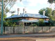
69-71 Forrest St Coolgardie
Leighton House
Coolgardie
Goldfields
Constructed from 1896
| Type | Status | Date | Documents |
|---|---|---|---|
| State Register | Registered | 22 Jun 2010 | HCWebsite.Listing+ListingDocument, HCWebsite.Listing+ListingDocument |
| Type | Status | Date | Documents |
|---|---|---|---|
| (no listings) |
| Type | Status | Date | Grading/Management | |
|---|---|---|---|---|
| Category | ||||
| Municipal Inventory | Adopted | 27 Jul 1995 | Category 2 | |
| Classified by the National Trust | Classified | |||
| Register of the National Estate | Permanent | 21 Mar 1978 | ||
The house has been built without foundations, which has led to problems with movement and cracking. The roof is in poor repair and requires attention.
Individual Building or Group
| Epoch | General | Specific |
|---|---|---|
| Present Use | RESIDENTIAL | Single storey residence |
| Other Use | MINING | Housing or Quarters |
| Original Use | MINING | Mine Office |
| Style |
|---|
| Federation Queen Anne |
| Type | General | Specific |
|---|---|---|
| Wall | STONE | Other Stone |
| Wall | BRICK | Face Brick |
| Roof | METAL | Corrugated Iron |
| General | Specific |
|---|---|
| DEMOGRAPHIC SETTLEMENT & MOBILITY | Settlements |
| DEMOGRAPHIC SETTLEMENT & MOBILITY | Depression & boom |
| OCCUPATIONS | Mining {incl. mineral processing} |
This information is provided voluntarily as a public service. The information provided is made available in good faith and is derived from sources believed to be reliable and accurate. However, the information is provided solely on the basis that readers will be responsible for making their own assessment of the matters discussed herein and are advised to verify all relevant representations, statements and information.
Constructed from 1890
One of the few surviving examples of the more opulent houses in Coolgardie.
A stone house with brick quoins and corrugated iron roof, featuring the generous verandahs and general opulence of permanent buildings of the late 1890s; bought in 1903, by Samuel Roe. The front elevation is richly detailed with french windows, double hung windows and panelled doors. It is of a very similar design to that at 85 Shaw Street.
The house is associated with Samuel Roe, though not built for him. A. E. Thomas owned it for a time and named it Leighton House; it was later bought by Eric Seahill and renamed Peter Pan by him. It was also used as offices for Anaconda Mining for a time.
High
Fair
| Owner | Category |
|---|---|
| W & M Moore | Other Private |
This information is provided voluntarily as a public service. The information provided is made available in good faith and is derived from sources believed to be reliable and accurate. However, the information is provided solely on the basis that readers will be responsible for making their own assessment of the matters discussed herein and are advised to verify all relevant representations, statements and information.
George Cowcill St Coolgardie
Coolgardie
Goldfields
Constructed from 1897
| Type | Status | Date | Documents |
|---|---|---|---|
| (no listings) |
| Type | Status | Date | Documents |
|---|---|---|---|
| (no listings) |
| Type | Status | Date | Grading/Management | |
|---|---|---|---|---|
| Category | ||||
| Municipal Inventory | Adopted | 27 Jul 1995 | Category 2 | |
Historic site
| Epoch | General | Specific |
|---|---|---|
| Present Use | Transport\Communications | Water: Other |
| Original Use | Transport\Communications | Water: Other |
This information is provided voluntarily as a public service. The information provided is made available in good faith and is derived from sources believed to be reliable and accurate. However, the information is provided solely on the basis that readers will be responsible for making their own assessment of the matters discussed herein and are advised to verify all relevant representations, statements and information.
Constructed from 1897
| Owner | Category |
|---|---|
| Shire of Coolgardie | Local Gov't |
This information is provided voluntarily as a public service. The information provided is made available in good faith and is derived from sources believed to be reliable and accurate. However, the information is provided solely on the basis that readers will be responsible for making their own assessment of the matters discussed herein and are advised to verify all relevant representations, statements and information.