Local Government
Coolgardie
Region
Goldfields
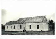
Reserve 2919 Bullabulling
Coolgardie
Goldfields
Constructed from 1895
| Type | Status | Date | Documents |
|---|---|---|---|
| State Register | Registered | 13 Aug 2004 | HCWebsite.Listing+ListingDocument, HCWebsite.Listing+ListingDocument |
| Type | Status | Date | Documents |
|---|---|---|---|
| (no listings) |
| Type | Status | Date | Grading/Management | |
|---|---|---|---|---|
| Category | ||||
| (no listings) | ||||
| Library Id | Title | Medium | Year Of Publication |
|---|---|---|---|
| 7359 | Conservation plan for Goldfields Water Supply Scheme. Volume II, place N : Bullabulling reservoir. | Heritage Study {Cons'n Plan} | 1999 |
| 6794 | Conservation plan for Bullabulling township and railway catchment. (draft) : a supplement to the Bullabulling Reservoir conservation plan (Goldfields Water Supply Scheme - place N). | Heritage Study {Cons'n Plan} | 2001 |
Historic site
| Epoch | General | Specific |
|---|---|---|
| Original Use | GOVERNMENTAL | Reservoir or Dam |
| Present Use | GOVERNMENTAL | Reservoir or Dam |
| Type | General | Specific |
|---|---|---|
| Other | STONE | Granite |
| General | Specific |
|---|---|
| TRANSPORT & COMMUNICATIONS | Rail & light rail transport |
This information is provided voluntarily as a public service. The information provided is made available in good faith and is derived from sources believed to be reliable and accurate. However, the information is provided solely on the basis that readers will be responsible for making their own assessment of the matters discussed herein and are advised to verify all relevant representations, statements and information.
Battery Rd Coolgardie
SE of Coolgardie, off the Coolgardie-Esperance Highway, off Norseman Rd.
Coolgardie
Goldfields
Constructed from 1902
| Type | Status | Date | Documents |
|---|---|---|---|
| State Register | Registered | 22 Jun 2001 | HCWebsite.Listing+ListingDocument, HCWebsite.Listing+ListingDocument |
| Type | Status | Date | Documents |
|---|---|---|---|
| (no listings) |
| Type | Status | Date | Grading/Management | |
|---|---|---|---|---|
| Category | ||||
| Classified by the National Trust | Classified | 27 Oct 1976 | ||
| Register of the National Estate | Permanent | 21 Mar 1978 | ||
| Municipal Inventory | Adopted | 27 Jul 1995 | Category 1 | |
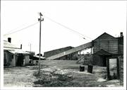
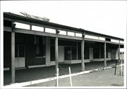
Industrial buildings with timber frames, clad in corrugated iron. The buildings have been on site since 1902, though the machinery has been upgraded several times, from steam power to gas to oil and finally to electricity.
Individual Building or Group
| Epoch | General | Specific |
|---|---|---|
| Present Use | MINING | Mining Battery |
| Original Use | MINING | Mining Battery |
| Type | General | Specific |
|---|---|---|
| Roof | METAL | Corrugated Iron |
| Wall | METAL | Corrugated Iron |
| General | Specific |
|---|---|
| OCCUPATIONS | Mining {incl. mineral processing} |
This information is provided voluntarily as a public service. The information provided is made available in good faith and is derived from sources believed to be reliable and accurate. However, the information is provided solely on the basis that readers will be responsible for making their own assessment of the matters discussed herein and are advised to verify all relevant representations, statements and information.
A representative industrial building form, housing an operation associated with goldmining and still in operation as a battery
The buildings are still the original ones, built in 1902. The machinery has been updated several times, converting from steam to gas to oil and then to electricity. The buildings are simple timber framed, corrugated iron lined industrial buildings designed for their particular functions; eg: stockpiles, crushing ore and extracting gold
Assessment 1976 Construction: 1902
This information is provided voluntarily as a public service. The information provided is made available in good faith and is derived from sources believed to be reliable and accurate. However, the information is provided solely on the basis that readers will be responsible for making their own assessment of the matters discussed herein and are advised to verify all relevant representations, statements and information.
Constructed from 1902
A representative industrial building form of historical significance, still performing the same gold extraction function for which it was built in 1902, and reflecting the mining history of Coolgardie.
The buildings are the original ones dating from 1902, comprising simple timber framed, corrugated iron lined industrial structures designed for their particular functions, ie stock pilling and crushing ore and extracting gold. The machinery has been updated several times, converting from steam to gas to oil and then to electricity.
One of a number of state built batteries and one of the few intact and remaining in operation.
High
Fair
| Ref ID No | Ref Name | Ref Source | Ref Date |
|---|---|---|---|
| National Trust Citation | |||
| Webb, M&A "The Centennial History of Kalgoorlie-Boulder" | 1993 |
| Owner | Category |
|---|---|
| I. Kean | Other Private |
This information is provided voluntarily as a public service. The information provided is made available in good faith and is derived from sources believed to be reliable and accurate. However, the information is provided solely on the basis that readers will be responsible for making their own assessment of the matters discussed herein and are advised to verify all relevant representations, statements and information.
Bayley St Coolgardie
Coolgardie
Goldfields
| Type | Status | Date | Documents |
|---|---|---|---|
| (no listings) |
| Type | Status | Date | Documents |
|---|---|---|---|
| (no listings) |
| Type | Status | Date | Grading/Management | |
|---|---|---|---|---|
| Category | ||||
| Classified by the National Trust | Classified | 27 Oct 1976 | ||
| Register of the National Estate | Permanent | 21 Mar 1978 | ||
00568 Warden's Court (fmr)
Individual Building or Group
| Epoch | General | Specific |
|---|---|---|
| Original Use | COMMERCIAL | Bank |
| Present Use | COMMERCIAL | Bank |
| General | Specific |
|---|---|
| OCCUPATIONS | Commercial & service industries |
This information is provided voluntarily as a public service. The information provided is made available in good faith and is derived from sources believed to be reliable and accurate. However, the information is provided solely on the basis that readers will be responsible for making their own assessment of the matters discussed herein and are advised to verify all relevant representations, statements and information.
Bayley St Coolgardie
Coolgardie
Goldfields
| Type | Status | Date | Documents |
|---|---|---|---|
| (no listings) |
| Type | Status | Date | Documents |
|---|---|---|---|
| (no listings) |
| Type | Status | Date | Grading/Management | |
|---|---|---|---|---|
| Category | ||||
| (no listings) | ||||
00568 Warden's Court (fmr)
Individual Building or Group
| Epoch | General | Specific |
|---|---|---|
| Original Use | MILITARY | Drill Hall |
| Present Use | MILITARY | Drill Hall |
This information is provided voluntarily as a public service. The information provided is made available in good faith and is derived from sources believed to be reliable and accurate. However, the information is provided solely on the basis that readers will be responsible for making their own assessment of the matters discussed herein and are advised to verify all relevant representations, statements and information.
Bayley St Coolgardie
Coolgardie
Goldfields
| Type | Status | Date | Documents |
|---|---|---|---|
| (no listings) |
| Type | Status | Date | Documents |
|---|---|---|---|
| (no listings) |
| Type | Status | Date | Grading/Management | |
|---|---|---|---|---|
| Category | ||||
| Statewide War Memorial Survey | Completed | 01 May 1996 | ||
00562 Marvel Bar Hotel (fmr), Coolgardie
Historic site
| Epoch | General | Specific |
|---|---|---|
| Present Use | MONUMENT\CEMETERY | Monument |
| Original Use | MONUMENT\CEMETERY | Monument |
| Type | General | Specific |
|---|---|---|
| Other | STONE | Other Stone |
| Other | BRICK | Common Brick |
| Other | METAL | Bronze |
| General | Specific |
|---|---|
| OUTSIDE INFLUENCES | World Wars & other wars |
This information is provided voluntarily as a public service. The information provided is made available in good faith and is derived from sources believed to be reliable and accurate. However, the information is provided solely on the basis that readers will be responsible for making their own assessment of the matters discussed herein and are advised to verify all relevant representations, statements and information.
Bayley St Coolgardie
Coolgardie
Goldfields
| Type | Status | Date | Documents |
|---|---|---|---|
| (no listings) |
| Type | Status | Date | Documents |
|---|---|---|---|
| (no listings) |
| Type | Status | Date | Grading/Management | |
|---|---|---|---|---|
| Category | ||||
| Classified by the National Trust | Classified | 27 Oct 1976 | ||
| Register of the National Estate | Permanent | 21 Mar 1978 | ||
00568 Warden's Court (fmr)
Individual Building or Group
| Epoch | General | Specific |
|---|---|---|
| Present Use | GOVERNMENTAL | Office or Administration Bldg |
| Original Use | GOVERNMENTAL | Office or Administration Bldg |
This information is provided voluntarily as a public service. The information provided is made available in good faith and is derived from sources believed to be reliable and accurate. However, the information is provided solely on the basis that readers will be responsible for making their own assessment of the matters discussed herein and are advised to verify all relevant representations, statements and information.
This information is provided voluntarily as a public service. The information provided is made available in good faith and is derived from sources believed to be reliable and accurate. However, the information is provided solely on the basis that readers will be responsible for making their own assessment of the matters discussed herein and are advised to verify all relevant representations, statements and information.
33 & 33A Bayley St Coolgardie
Marvel Loch Hotel
RSL Building
Coolgardie
Goldfields
Constructed from 1898
| Type | Status | Date | Documents |
|---|---|---|---|
| State Register | Registered | 22 Jun 2012 | HCWebsite.Listing+ListingDocument, HCWebsite.Listing+ListingDocument |
| Type | Status | Date | Documents |
|---|---|---|---|
| (no listings) |
| Type | Status | Date | Grading/Management | |
|---|---|---|---|---|
| Category | ||||
| Municipal Inventory | Adopted | 27 Jul 1995 | Category 2 | |
| Statewide Hotel Survey | Completed | 01 Nov 1997 | ||
| Register of the National Estate | Permanent | 21 Mar 1978 | ||
| Classified by the National Trust | Classified | 06 Dec 1976 | ||
Overall the place is in poor condition. Exterior treatments are in some places in very poor condition and inappropriate cement-rich and concrete repairs are likely to be damaging the stone and brickwork. Interior features such as fireplaces, balusters and glazing are missing elements in several areas.
| Name | Type | Year From | Year To |
|---|---|---|---|
| Ernest Barton Hack | Architect | 1897 | - |
| Library Id | Title | Medium | Year Of Publication |
|---|---|---|---|
| 9440 | Marvel Bar Hotel (Fmr), Coolgardie. | Heritage Study {Cons'n Plan} | 2009 |
Individual Building or Group
| Epoch | General | Specific |
|---|---|---|
| Original Use | COMMERCIAL | Hotel, Tavern or Inn |
| Present Use | SOCIAL\RECREATIONAL | RSL Hall |
| Style |
|---|
| Federation Free Classical |
| Type | General | Specific |
|---|---|---|
| Wall | BRICK | Rendered Brick |
| Roof | METAL | Corrugated Iron |
| Wall | STONE | Local Stone |
| General | Specific |
|---|---|
| DEMOGRAPHIC SETTLEMENT & MOBILITY | Resource exploitation & depletion |
| DEMOGRAPHIC SETTLEMENT & MOBILITY | Depression & boom |
| OCCUPATIONS | Hospitality industry & tourism |
This information is provided voluntarily as a public service. The information provided is made available in good faith and is derived from sources believed to be reliable and accurate. However, the information is provided solely on the basis that readers will be responsible for making their own assessment of the matters discussed herein and are advised to verify all relevant representations, statements and information.
Constructed from 1898
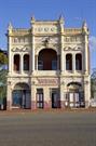
A splendid, elaborately decorated building of critical importance in the Bayley Street precinct because it survived the devastation of this street and stands as an example of the opulence and confidence of Coolgardie around 1900.
A two storey brick building with an elaborate stuccoed facade. The ground floor consists of squat Corinthian pilasters and elaborate flat arches. The upper floor has a deeply arcaded verandah with a central arch and smaller flanking openings with architraves to the piers and free floating pediments over. The parapet is decorated with blind arches, balusters and stout crockets.
The hotel with its elaborate design which complemented its hospitality role was an ambitious, permanent structure demonstrating the great confidence in the town's future at the turn of the century. It remained in operation until 1927.
Low-Moderate
Fair-Good
| Name | Type | Year From | Year To |
|---|---|---|---|
| Ernest Barton Hack | Architect | 1897 | - |
| Ref ID No | Ref Name | Ref Source | Ref Date |
|---|---|---|---|
| Webb, M&A "The Centennial History of Kalgoorlie-Boulder" | 1993 |
| Owner | Category |
|---|---|
| RSL Club | Other Private |
This information is provided voluntarily as a public service. The information provided is made available in good faith and is derived from sources believed to be reliable and accurate. However, the information is provided solely on the basis that readers will be responsible for making their own assessment of the matters discussed herein and are advised to verify all relevant representations, statements and information.
An exceptional facade, type former hotel: an important remnant of the past glories of Bayley St
A two storied building with elaborate stuccoed facade. a splendid, if vulgar, building now of critical importance in Bayley St because it survives the devastation of this street and stands as an overstated example of the opulence and confidence of the Coolgardie of around 1900 or 1898.
Assessment 1976
This information is provided voluntarily as a public service. The information provided is made available in good faith and is derived from sources believed to be reliable and accurate. However, the information is provided solely on the basis that readers will be responsible for making their own assessment of the matters discussed herein and are advised to verify all relevant representations, statements and information.
55-59 Bayley St Coolgardie
Coolgardie
Goldfields
| Type | Status | Date | Documents |
|---|---|---|---|
| (no listings) |
| Type | Status | Date | Documents |
|---|---|---|---|
| (no listings) |
| Type | Status | Date | Grading/Management | |
|---|---|---|---|---|
| Category | ||||
| Classified by the National Trust | Classified | 27 Oct 1976 | ||
| Register of the National Estate | Permanent | 21 Mar 1978 | ||
| Municipal Inventory | Adopted | 27 Jul 1995 | Category 5 | |
00568 Warden's Court (fmr)
Historic site
| Epoch | General | Specific |
|---|---|---|
| Present Use | EDUCATIONAL | Museum |
| Original Use | Transport\Communications | Comms: Post or Telegraph Office |
| General | Specific |
|---|---|
| OCCUPATIONS | Intellectual activities, arts&craft |
This information is provided voluntarily as a public service. The information provided is made available in good faith and is derived from sources believed to be reliable and accurate. However, the information is provided solely on the basis that readers will be responsible for making their own assessment of the matters discussed herein and are advised to verify all relevant representations, statements and information.
Socially significant but presents aesthetic difficulties for Bayley Street.
Acollection of objects related to the Goldfields, gathered by Ben Prior.
A collection of objects and equipment representative of the gold mining industry and donated to the Shire of Coolgardie.
High
Very Poor
| Owner | Category |
|---|---|
| Shire of Coolgardie | Local Gov't |
This information is provided voluntarily as a public service. The information provided is made available in good faith and is derived from sources believed to be reliable and accurate. However, the information is provided solely on the basis that readers will be responsible for making their own assessment of the matters discussed herein and are advised to verify all relevant representations, statements and information.
56-60 Bayley St Coolgardie
Gaol, Police Station and Warden's Court
Post Office
Coolgardie
Goldfields
Constructed from 1894 to 1898
| Type | Status | Date | Documents |
|---|---|---|---|
| State Register | Registered | 30 Sep 1994 | HCWebsite.Listing+ListingDocument, HCWebsite.Listing+ListingDocument |
| Type | Status | Date | Documents |
|---|---|---|---|
| (no listings) |
| Type | Status | Date | Grading/Management | |
|---|---|---|---|---|
| Category | ||||
| Register of the National Estate | Permanent | 21 Mar 1978 | ||
| Classified by the National Trust | Classified | 11 Jun 1973 | ||
| Municipal Inventory | Adopted | 27 Jul 1995 | Category 1 | |
| Name | Type | Year From | Year To |
|---|---|---|---|
| George Temple Poole | Architect | - | - |
| John (Harry) Grainger | Architect | - | - |
| Library Id | Title | Medium | Year Of Publication |
|---|---|---|---|
| 11358 | Cast iron pillar boxes of Western Australia: An early history of the J & E Ledger foundry | Book | 2015 |
| 1073 | Coolgardie Post Office Complex : Conservation Plan : Shire of Coolgardie | Heritage Study {Cons'n Plan} | 1995 |
| 927 | Shire of Coolgardie post office complex | Report | 1994 |
| 3669 | Coolgardie Post Office : conservation works. | Report | 1998 |
| 5367 | Coolgardie Post Office : final works report / Considine & Griffiths Architects Pty Ltd. | Conservation works report | 2002 |
| 1049 | Coolgardie Post Office Complex: Conservation Plan | Heritage Study {Cons'n Plan} | 1994 |
| 4173 | Coolgardie Railway Station and Post Office Conservation Works 1998-Structure | Report | 1998 |
| 11805 | Coolgardie Post office Complex | Heritage Study {Cons'n Plan} | 2020 |
| 11935 | Coolgardie Post Office complex | Heritage Study {Cons'n Plan} | 2020 |
| 1127 | Coolgardie post office | Report | 1996 |
Individual Building or Group
| Epoch | General | Specific |
|---|---|---|
| Original Use | Transport\Communications | Comms: Post or Telegraph Office |
| Original Use | GOVERNMENTAL | Police Station or Quarters |
| Original Use | GOVERNMENTAL | Gaol |
| Present Use | COMMERCIAL | Shop\Retail Store {single} |
| Present Use | Transport\Communications | Comms: Post or Telegraph Office |
| Style |
|---|
| Federation Arts and Crafts |
| Type | General | Specific |
|---|---|---|
| Roof | METAL | Corrugated Iron |
| Wall | STONE | Sandstone, other |
| General | Specific |
|---|---|
| OCCUPATIONS | Intellectual activities, arts&craft |
| OCCUPATIONS | Commercial & service industries |
This information is provided voluntarily as a public service. The information provided is made available in good faith and is derived from sources believed to be reliable and accurate. However, the information is provided solely on the basis that readers will be responsible for making their own assessment of the matters discussed herein and are advised to verify all relevant representations, statements and information.
Historically interesting for association with postal services from early goldrush period. Now important to Coolgardie as part of the complex of stone government buildings in Bayley St and significant as one of the tourist attractions of Coolgardie Ghost town being promoted.
The building consists of several sections built between 1894 and 1898. It originally housed the Post Office, the Police Station a drill hall and living quarters. The Post Office and living quarters remain; The Police Station is now a tourist Bureau and Gallery; the Drill Hall is disused. The buildings are built of stone with brick Quoins and window surrounds, the roof is corrugated iron, The different sections vary between one and two storeys in height, with verandahs separating the two storey facade. Building has concrete foundations, stone & brick walls, iron roofs. Interior in good condition (1969) and building then well maintained although some fretting evident on exterior stone work.
Assessment 1976 Construction 1894, 1898 and later Original use: Police Station & Goal, police quarters, drill Hall, postal quarters, Post & Telegraph office. Builder: 1st part, contract let to J.C. Braidwood for £ 7,060 completed 2.5.1895. Later two storey building facing Hunt St completed 12.1.1898. Contract let to J.Pringle for £4,932 Architect: Public Works Department
This information is provided voluntarily as a public service. The information provided is made available in good faith and is derived from sources believed to be reliable and accurate. However, the information is provided solely on the basis that readers will be responsible for making their own assessment of the matters discussed herein and are advised to verify all relevant representations, statements and information.
Constructed from 1898, Constructed from 1894
The form, scale and massing of the building demonstrates the architectural skills of George Temple Poole, a prominent architect and Superintendent of the Public Works Department. The building helps to define the historic character of Coolgardie's main street. The building strongly contributes to the sense of identity of Coolgardie; a key town in the development of gold mining in Western Australia int he 1890's.
The building complex grew in four major campaigns between 1894 and 1907 as a result of the rapid growth of Coolgardie, however the building is "well proportioned with a good relationship of different parts". The complex is an intricate picturesque combination of two and one storey parts with verandahs to the former residential areas and a colonnade outside the old postal hall. Some of the ornate chimneys and drawn glass panes in windows remain and adze marks can be seen on some floor boards.
The rapid population growth of the goldfields required a post office, it was immediately too small and more accommodation was built in 1896, 1898 and 1907. Designed by George Temple Poole, influential architect, Superintendent of the Public Works Department and Colonial Architect from 1891-1896. Hilson Beasley Supt. P.W.D.
High
Good
| Name | Type | Year From | Year To |
|---|---|---|---|
| George Temple Poole | Architect | - | - |
| John (Harry) Grainger | Architect | - | - |
| Ref ID No | Ref Name | Ref Source | Ref Date |
|---|---|---|---|
| "Documentation of Places for Entry in the Register of Heritage Places" | Heritage Council | 1994 | |
| "Conservation Plan" | Considine and Griffiths Architects Pty Ltd | 1994 |
| Owner | Category |
|---|---|
| Minister for Works | State Gov't |
This information is provided voluntarily as a public service. The information provided is made available in good faith and is derived from sources believed to be reliable and accurate. However, the information is provided solely on the basis that readers will be responsible for making their own assessment of the matters discussed herein and are advised to verify all relevant representations, statements and information.
75-77 Bayley St Coolgardie
Ghost Inn Hotel, Michelle Lodge
Gold Rush Lodge, Railway Lodge
Coolgardie
Goldfields
Constructed from 1896 to 1990
| Type | Status | Date | Documents |
|---|---|---|---|
| State Register | Registered | 27 Dec 2002 | HCWebsite.Listing+ListingDocument, HCWebsite.Listing+ListingDocument |
| Type | Status | Date | Documents |
|---|---|---|---|
| (no listings) |
| Type | Status | Date | Grading/Management | |
|---|---|---|---|---|
| Category | ||||
| Municipal Inventory | Adopted | 27 Jul 1995 | Category 1 | |
| Register of the National Estate | Permanent | 21 Mar 1978 | ||
| Statewide Hotel Survey | Completed | 01 Nov 1997 | ||
| Classified by the National Trust | Classified | 27 Oct 1976 | ||
| Library Id | Title | Medium | Year Of Publication |
|---|---|---|---|
| 7310 | Railway Hotel, Coolgardie, Western Australia : conservation works (Final report). | Conservation works report | 2005 |
| 8779 | Railway Hotel, (fmr) | Conservation works report | 2007 |
| 8774 | Railway Hotel, Coolgardie; Western Australia. | Report | 2007 |
| 4813 | Railway Hotel (former), Coolgardie : conservation plan. | Heritage Study {Cons'n Plan} | 2000 |
| 9216 | Railway Hotel, (Fmr) Coolgardie, Western Australia. Final report - Heritage Council Grants Program 2007/08 Grant: 1/642 Job No:07154 | Conservation works report | 2009 |
Individual Building or Group
| Epoch | General | Specific |
|---|---|---|
| Original Use | COMMERCIAL | Office or Administration Bldg |
| Other Use | COMMERCIAL | Hotel, Tavern or Inn |
| Present Use | RESIDENTIAL | Institutional Housing |
| Style |
|---|
| Federation Filigree |
| Federation Free Classical |
| Type | General | Specific |
|---|---|---|
| Other | TIMBER | Other Timber |
| Roof | METAL | Corrugated Iron |
| Wall | BRICK | Other Brick |
| General | Specific |
|---|---|
| OCCUPATIONS | Hospitality industry & tourism |
This information is provided voluntarily as a public service. The information provided is made available in good faith and is derived from sources believed to be reliable and accurate. However, the information is provided solely on the basis that readers will be responsible for making their own assessment of the matters discussed herein and are advised to verify all relevant representations, statements and information.
Constructed from 1898
Architecturally significant as a surviving element, close to its original character, in the Bayley Street streetscape. Important in the definition of the historic Bayley Street precinct.
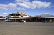
A simple two storied brick corner hotel with a two storeyed verandah and corrugated iron roof, originally built as a bonded store and later converted and extended as an hotel. The exterior is fairly authentic but the interior has been compromised by a series of alterations and additions and the removal of the bars. The hotel was de-licenced in the 1960s.
A representative type of hotel in a relatively unchanged state from the main period of Coolgardie's development when 26 hotels operated in the town.
Moderate-High
Fair
| Ref ID No | Ref Name | Ref Source | Ref Date |
|---|---|---|---|
| Webb, M&A "The Centennial History of Kalgoorlie-Boulder" | 1993 |
| Owner | Category |
|---|---|
| M&J Charlton | Other Private |
This information is provided voluntarily as a public service. The information provided is made available in good faith and is derived from sources believed to be reliable and accurate. However, the information is provided solely on the basis that readers will be responsible for making their own assessment of the matters discussed herein and are advised to verify all relevant representations, statements and information.
77 Bayley St Coolgardie
Coolgardie
Goldfields
Constructed from 1900
| Type | Status | Date | Documents |
|---|---|---|---|
| (no listings) |
| Type | Status | Date | Documents |
|---|---|---|---|
| (no listings) |
| Type | Status | Date | Grading/Management | |
|---|---|---|---|---|
| Category | ||||
| Classified by the National Trust | Classified | 27 Oct 1976 | ||
| Register of the National Estate | Registered | 21 Mar 1978 | ||
| Municipal Inventory | Adopted | 27 Jul 1995 | Category 2 | |
00570 Railway Hotel (fmr), Coolgardie
Individual Building or Group
| Epoch | General | Specific |
|---|---|---|
| Present Use | COMMERCIAL | Office or Administration Bldg |
| Original Use | COMMERCIAL | Shopping Complex |
| General | Specific |
|---|---|
| OCCUPATIONS | Commercial & service industries |
This information is provided voluntarily as a public service. The information provided is made available in good faith and is derived from sources believed to be reliable and accurate. However, the information is provided solely on the basis that readers will be responsible for making their own assessment of the matters discussed herein and are advised to verify all relevant representations, statements and information.
A significant part of the Bayley Street precinct. A minor but important surviving part of Bayley Street's 19th Century streetscape illustrating its small scale, lightly constructed commercial nature.
A group of 4 places with shop front windows and a verandah over the footpath constructed from tiber framing. One has an original sign stating "Billiards" hanging from under the verandah. Part of the eastern end of the structure was built from brick and formed part of the neighbouring hotel.
Part of the late 19th Century main street development terminating the western edge of the commercial centre.
Moderate-High
Fair
| Owner | Category |
|---|---|
| M&J Charlton | Other Private |
This information is provided voluntarily as a public service. The information provided is made available in good faith and is derived from sources believed to be reliable and accurate. However, the information is provided solely on the basis that readers will be responsible for making their own assessment of the matters discussed herein and are advised to verify all relevant representations, statements and information.
Forrest St Coolgardie
Coolgardie
Goldfields
Constructed from 1890 to 1894
| Type | Status | Date | Documents |
|---|---|---|---|
| State Register | Registered | 20 Aug 1993 | HCWebsite.Listing+ListingDocument |
| Type | Status | Date | Documents |
|---|---|---|---|
| (no listings) |
| Type | Status | Date | Grading/Management | |
|---|---|---|---|---|
| Category | ||||
| Municipal Inventory | Adopted | 27 Jul 1995 | Category 1 | |
| Register of the National Estate | Permanent | 21 Mar 1978 | ||
| Classified by the National Trust | Classified | 06 Dec 1976 | ||
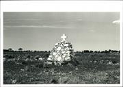
The register entry includes two intact headstones, other stone grave markers, and a memorial, and the land on which they stand being Reserve 6441.
Other Built Type
| Epoch | General | Specific |
|---|---|---|
| Original Use | MONUMENT\CEMETERY | Cemetery |
| Present Use | VACANT\UNUSED | Vacant\Unused |
| General | Specific |
|---|---|
| DEMOGRAPHIC SETTLEMENT & MOBILITY | Settlements |
This information is provided voluntarily as a public service. The information provided is made available in good faith and is derived from sources believed to be reliable and accurate. However, the information is provided solely on the basis that readers will be responsible for making their own assessment of the matters discussed herein and are advised to verify all relevant representations, statements and information.
Historical and social associations with the first settlers of the district.
The cemetery is a fenced area of land, approximately 50m by 50m. It contains two graves which are intact and several piles of stones marking locations of other graves. There is also a memorial to the early pioneers.
Assessment 1976: Site and intant headstones and railings The first burial ground in Coolgardie, containing the graves of the first 32 burials, the most notable of which is the grave of Holland, the renowned discoverer of underground water sources and trail blazer in the early days of the district.
This information is provided voluntarily as a public service. The information provided is made available in good faith and is derived from sources believed to be reliable and accurate. However, the information is provided solely on the basis that readers will be responsible for making their own assessment of the matters discussed herein and are advised to verify all relevant representations, statements and information.
Constructed from 1890
As Coolgardie's first burial ground, the cemetery is significant for its historical link with the early history of the town and important figures in the town's development.
The cemetery is a fenced off area of land, approximately 50m x 50m. It contains two graves which are intact, and several piles of stones marking the location of other graves. There is also a memorial to the early pioneers. This was the first burial ground in Coolgardie, containing the graves of the first 32 burials, the most notable of which is the grave of Walsh, the noted discoverer of the underground water source and early explorer.
The first cemetery in Coolgardie, later abandoned as being too close to the rapidly expanding town in 1894.
Moderate
Fair
| Ref ID No | Ref Name | Ref Source | Ref Date |
|---|---|---|---|
| Webb, M&A "The Centennial History of Kalgoorlie-Boulder" | 1993 |
| Owner | Category |
|---|---|
| Shire of Coolgardie | Local Gov't |
This information is provided voluntarily as a public service. The information provided is made available in good faith and is derived from sources believed to be reliable and accurate. However, the information is provided solely on the basis that readers will be responsible for making their own assessment of the matters discussed herein and are advised to verify all relevant representations, statements and information.
69-71 Forrest St Coolgardie
Leighton House
Coolgardie
Goldfields
Constructed from 1896
| Type | Status | Date | Documents |
|---|---|---|---|
| State Register | Registered | 22 Jun 2010 | HCWebsite.Listing+ListingDocument, HCWebsite.Listing+ListingDocument |
| Type | Status | Date | Documents |
|---|---|---|---|
| (no listings) |
| Type | Status | Date | Grading/Management | |
|---|---|---|---|---|
| Category | ||||
| Municipal Inventory | Adopted | 27 Jul 1995 | Category 2 | |
| Classified by the National Trust | Classified | |||
| Register of the National Estate | Permanent | 21 Mar 1978 | ||
The house has been built without foundations, which has led to problems with movement and cracking. The roof is in poor repair and requires attention.
Individual Building or Group
| Epoch | General | Specific |
|---|---|---|
| Present Use | RESIDENTIAL | Single storey residence |
| Other Use | MINING | Housing or Quarters |
| Original Use | MINING | Mine Office |
| Style |
|---|
| Federation Queen Anne |
| Type | General | Specific |
|---|---|---|
| Wall | STONE | Other Stone |
| Wall | BRICK | Face Brick |
| Roof | METAL | Corrugated Iron |
| General | Specific |
|---|---|
| DEMOGRAPHIC SETTLEMENT & MOBILITY | Settlements |
| DEMOGRAPHIC SETTLEMENT & MOBILITY | Depression & boom |
| OCCUPATIONS | Mining {incl. mineral processing} |
This information is provided voluntarily as a public service. The information provided is made available in good faith and is derived from sources believed to be reliable and accurate. However, the information is provided solely on the basis that readers will be responsible for making their own assessment of the matters discussed herein and are advised to verify all relevant representations, statements and information.
Constructed from 1890
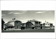
One of the few surviving examples of the more opulent houses in Coolgardie.
A stone house with brick quoins and corrugated iron roof, featuring the generous verandahs and general opulence of permanent buildings of the late 1890s; bought in 1903, by Samuel Roe. The front elevation is richly detailed with french windows, double hung windows and panelled doors. It is of a very similar design to that at 85 Shaw Street.
The house is associated with Samuel Roe, though not built for him. A. E. Thomas owned it for a time and named it Leighton House; it was later bought by Eric Seahill and renamed Peter Pan by him. It was also used as offices for Anaconda Mining for a time.
High
Fair
| Owner | Category |
|---|---|
| W & M Moore | Other Private |
This information is provided voluntarily as a public service. The information provided is made available in good faith and is derived from sources believed to be reliable and accurate. However, the information is provided solely on the basis that readers will be responsible for making their own assessment of the matters discussed herein and are advised to verify all relevant representations, statements and information.
Great Eastern Hwy Coolgardie
west of Coolgardie.
Coolgardie
Goldfields
Constructed from 1894
| Type | Status | Date | Documents |
|---|---|---|---|
| State Register | Registered | 20 Aug 1993 | HCWebsite.Listing+ListingDocument |
| Type | Status | Date | Documents |
|---|---|---|---|
| (no listings) |
| Type | Status | Date | Grading/Management | |
|---|---|---|---|---|
| Category | ||||
| Municipal Inventory | Adopted | 27 Jul 1995 | Category 1 | |
| Classified by the National Trust | Classified | 06 Dec 1976 | ||
| Register of the National Estate | Permanent | 21 Mar 1978 | ||
The register entry includes stone and timber headstones and cast iron railings, and the land on which they stand being Reserve 2772.
Other Built Type
| Epoch | General | Specific |
|---|---|---|
| Original Use | MONUMENT\CEMETERY | Cemetery |
| Present Use | MONUMENT\CEMETERY | Cemetery |
| General | Specific |
|---|---|
| DEMOGRAPHIC SETTLEMENT & MOBILITY | Settlements |
This information is provided voluntarily as a public service. The information provided is made available in good faith and is derived from sources believed to be reliable and accurate. However, the information is provided solely on the basis that readers will be responsible for making their own assessment of the matters discussed herein and are advised to verify all relevant representations, statements and information.
Social and historic associations with the foundation of Coolgardie
The current cemetery for the district located west of the townsite area, established in 1894 and containing the graves of many of the early people who worked to establish the town of Coolgardie
Assessment: 1976 Construction 1894
This information is provided voluntarily as a public service. The information provided is made available in good faith and is derived from sources believed to be reliable and accurate. However, the information is provided solely on the basis that readers will be responsible for making their own assessment of the matters discussed herein and are advised to verify all relevant representations, statements and information.
Constructed from 1894
The cemetery is of substantial historical and social significance, providing a link with a number of individuals who played the role in the foundation of the town.
The current cemetery for the district, located west of the townsite area, established in 1894 and containing the graves of many of the early people who worked to establish the town of Coolgardie. The register entry includes stone and timber headstones and cast iron railings, and the land on which they stand, which is reserve 2772. The site is maintained by the Shire of Coolgardie.
Coolgardie's second cemetery contains in excess of 1000 burials and many of the headstones tell of the hardship of life in the goldfields, including the famous and ordinary folk; Ernest Giles spent his last years in Coolgardie and was buried in this cemetery.
High
Varying
| Ref ID No | Ref Name | Ref Source | Ref Date |
|---|---|---|---|
| Webb, M&A "The Centennial History of Kalgoorlie-Boulder" | 1993 |
| Owner | Category |
|---|---|
| Shire of Coolgardie | Local Gov't |
This information is provided voluntarily as a public service. The information provided is made available in good faith and is derived from sources believed to be reliable and accurate. However, the information is provided solely on the basis that readers will be responsible for making their own assessment of the matters discussed herein and are advised to verify all relevant representations, statements and information.
Cnr Hunt & Shaw Sts Coolgardie
N of Bayley St
Coolgardie
Goldfields
Constructed from 1897
| Type | Status | Date | Documents |
|---|---|---|---|
| State Register | Registered | 23 Mar 2010 | HCWebsite.Listing+ListingDocument, HCWebsite.Listing+ListingDocument |
| Type | Status | Date | Documents |
|---|---|---|---|
| (no listings) |
| Type | Status | Date | Grading/Management | |
|---|---|---|---|---|
| Category | ||||
| Register of the National Estate | Permanent | 21 Mar 1978 | ||
| Classified by the National Trust | Classified | 27 Oct 1976 | ||
| Municipal Inventory | Adopted | 27 Jul 1995 | Category 1 | |
Coolgardie Primary School is generally in good condition, with regular maintenance taking place.
| Name | Type | Year From | Year To |
|---|---|---|---|
| G T Poole (1897 building) | Architect | 1897 | 1897 |
| Hillson Beasley (1900 extensions) | Architect | 1900 | 1900 |
Individual Building or Group
| Epoch | General | Specific |
|---|---|---|
| Present Use | EDUCATIONAL | Primary School |
| Original Use | EDUCATIONAL | Combined School |
| Style |
|---|
| Federation Queen Anne |
| Vernacular |
| Type | General | Specific |
|---|---|---|
| Roof | METAL | Corrugated Iron |
| Wall | STONE | Local Stone |
| General | Specific |
|---|---|
| DEMOGRAPHIC SETTLEMENT & MOBILITY | Settlements |
| PEOPLE | Aboriginal people |
| SOCIAL & CIVIC ACTIVITIES | Education & science |
| OCCUPATIONS | Mining {incl. mineral processing} |
| DEMOGRAPHIC SETTLEMENT & MOBILITY | Resource exploitation & depletion |
| SOCIAL & CIVIC ACTIVITIES | Community services & utilities |
This information is provided voluntarily as a public service. The information provided is made available in good faith and is derived from sources believed to be reliable and accurate. However, the information is provided solely on the basis that readers will be responsible for making their own assessment of the matters discussed herein and are advised to verify all relevant representations, statements and information.
Constructed from 1897
The school is of great historical significance and cultural importance, being the first permanent government school in the town and still in use. It is also of architectural significance as an example of the architecture of George Temple Poole and his adaption of school building design for the hot climate.
The school has roucg finished, random coursed stone walls with brick quoins, a corrugated iron roof and a surrounding verandah for weather protection. The building is rectangular and has seven rooms. The verandah construction has been modified and the roof is also a replacement. Windows are double hung casements with stucco lintols and sills.
This building was the first permanent school structure in the Eastern Goldfields. George Temple Poole, one of the colony's most influential architects, designed the school when he was Superintendent of the Public Works Department and Colonial Architect from 1891-1896.
High
Good
| Name | Type | Year From | Year To |
|---|---|---|---|
| G T Poole | Architect | - | - |
| Ref ID No | Ref Name | Ref Source | Ref Date |
|---|---|---|---|
| Webb, M&A "The Centennial History of Kalgoorlie-Boulder" | 1993 |
This information is provided voluntarily as a public service. The information provided is made available in good faith and is derived from sources believed to be reliable and accurate. However, the information is provided solely on the basis that readers will be responsible for making their own assessment of the matters discussed herein and are advised to verify all relevant representations, statements and information.
The original school building, still in use and good condition
A seven room school building, built of stone with a corrugated iron roof. The building is a simple style, rectangular with a verandah all round. The stonework is fairly rough and laid in a random patter. The building is well maintained andhas been recently re roofed
Assessment 1976 Architect: George Temple Poole Builder: Philp & Royal Date of construction 1897
This information is provided voluntarily as a public service. The information provided is made available in good faith and is derived from sources believed to be reliable and accurate. However, the information is provided solely on the basis that readers will be responsible for making their own assessment of the matters discussed herein and are advised to verify all relevant representations, statements and information.
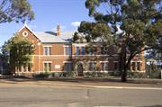
85-93 Lindsay St Coolgardie
Christian Aboriginal Parent-Directed School
Convent School
Coolgardie
Goldfields
Constructed from 1903
| Type | Status | Date | Documents |
|---|---|---|---|
| State Register | Registered | 01 Jul 1994 | HCWebsite.Listing+ListingDocument |
| Type | Status | Date | Documents |
|---|---|---|---|
| (no listings) |
| Type | Status | Date | Grading/Management | |
|---|---|---|---|---|
| Category | ||||
| Municipal Inventory | Adopted | 27 Jul 1995 | Category 1 | |
| Classified by the National Trust | Classified | 06 Dec 1976 | ||
| Register of the National Estate | Permanent | 21 Mar 1978 | ||
| Name | Type | Year From | Year To |
|---|---|---|---|
| Michael Cavanagh | Architect | - | - |
| Sisters of Mercy | Architect | - | - |
| Library Id | Title | Medium | Year Of Publication |
|---|---|---|---|
| 5645 | St Anthony's Convent, Coolgardie CAPS East Ward verandah reconstruction : final conservation works report. | Conservation works report | 2002 |
| 1370 | St Anthony's Convent Coolgardie: Conservation Plan | Heritage Study {Cons'n Plan} | 1996 |
| 183 | Conservation of St Anthony's Convent Coolgardie final report for Christian Aboriginal Parent Directed School Inc | Report | 1992 |
Individual Building or Group
| Epoch | General | Specific |
|---|---|---|
| Original Use | RELIGIOUS | Monastery or Convent |
| Present Use | EDUCATIONAL | Other |
| Style |
|---|
| Federation Free Style |
| Type | General | Specific |
|---|---|---|
| Wall | BRICK | Other Brick |
| Roof | METAL | Corrugated Iron |
| General | Specific |
|---|---|
| SOCIAL & CIVIC ACTIVITIES | Education & science |
| SOCIAL & CIVIC ACTIVITIES | Religion |
This information is provided voluntarily as a public service. The information provided is made available in good faith and is derived from sources believed to be reliable and accurate. However, the information is provided solely on the basis that readers will be responsible for making their own assessment of the matters discussed herein and are advised to verify all relevant representations, statements and information.
Historically interseting and typical of the last two decades of the 19th century; the preservation of which would be encouraged and for continuing educational work, particularly for Goldfields girls of school age.
St Anthony's Convent of Mercy is a large U-shaped two storey building. It is constructed of brick with a corrugated iron roof, and has decorative stucco mouldings and string courses on all facades. The street facade is symmetrical, with a central main door and two large gables on the sides.
Assessment 1976 Constructed 1902
This information is provided voluntarily as a public service. The information provided is made available in good faith and is derived from sources believed to be reliable and accurate. However, the information is provided solely on the basis that readers will be responsible for making their own assessment of the matters discussed herein and are advised to verify all relevant representations, statements and information.
The place has historic significance related to the important role of education in the history of the Goldfields and contributes to the sense of place and identity of Coolgardie, a key town in the development of goldmining in W.A. in the 1890's. The building is a simple, understated but visually impressive example of Federation Free Style applied to an educational building and is representative of the work of prominent Perth architect M. Cavanagh from 1895-1938.
The school has a broad symmetrical facade, in which the weighty details of the central bay are balanced by two slightly projecting gabled wings. The central entrance door has a small frieze with the words "Convent of Mercy" and a shallow central gable. The gabled wings have two storey bay windows with semi-circular parapets, circular moulded air vents and are topped with masonry crosses. The building has a steeply pitched corrugated iron roof with a timber verandah to the rear and sides.
This school was run by the Sisters of Mercy for 75 years, it was the only boarding school on the Goldfields. No discrimination was made on the basis of religious denomination. Cavanagh, a prominent Perth architect from 1895-1935, designed many of the Catholic Church's buildings in W.A. at this time as well as many commercial, civic and residential buildings.
High
Fair
| Name | Type | Year From | Year To |
|---|---|---|---|
| M Cavanagh | Architect | - | - |
| Ref ID No | Ref Name | Ref Source | Ref Date |
|---|---|---|---|
| "Plans (1902)" | Sisters of Mercy Archives | 1902 | |
| "Documentation of Places for entry into the Register of Heritage Places" | Heritage Council | 1993 |
| Owner | Category |
|---|---|
| Christian Aboriginal Parent Directed School | Other Private |
This information is provided voluntarily as a public service. The information provided is made available in good faith and is derived from sources believed to be reliable and accurate. However, the information is provided solely on the basis that readers will be responsible for making their own assessment of the matters discussed herein and are advised to verify all relevant representations, statements and information.
87 Lindsay St Coolgardie
NOTE: REGISTERED PLACE AS PART OF 573
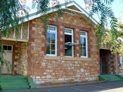
Theatre Royal (fmr)
Coolgardie
Goldfields
Constructed from 1895
| Type | Status | Date | Documents |
|---|---|---|---|
| (no listings) |
| Type | Status | Date | Documents |
|---|---|---|---|
| (no listings) |
| Type | Status | Date | Grading/Management | |
|---|---|---|---|---|
| Category | ||||
| Municipal Inventory | Adopted | 27 Jul 1995 | Category 1 | |
| Register of the National Estate | Registered | 21 Mar 1978 | ||
| Classified by the National Trust | Recorded | 27 Oct 1976 | ||
00573 St Anthony's Convent of Mercy (fmr),
Individual Building or Group
| Epoch | General | Specific |
|---|---|---|
| Other Use | EDUCATIONAL | Combined School |
| Present Use | SOCIAL\RECREATIONAL | Other Community Hall\Centre |
| Original Use | SOCIAL\RECREATIONAL | Theatre or Cinema |
| Style |
|---|
| Vernacular |
| Type | General | Specific |
|---|---|---|
| Roof | METAL | Corrugated Iron |
| Wall | TIMBER | Weatherboard |
| General | Specific |
|---|---|
| SOCIAL & CIVIC ACTIVITIES | Education & science |
| SOCIAL & CIVIC ACTIVITIES | Cultural activities |
This information is provided voluntarily as a public service. The information provided is made available in good faith and is derived from sources believed to be reliable and accurate. However, the information is provided solely on the basis that readers will be responsible for making their own assessment of the matters discussed herein and are advised to verify all relevant representations, statements and information.
Constructed from 1900
Significant as an integral part of the convent school and a typical gold fields structure.
A simple gabled hall with entry porch and some minor creations that is clearly identifiable as an ecclesiastical building.
An early example of an educational and multi-use hall.
Moderate-High
Fair
| Ref ID No | Ref Name | Ref Source | Ref Date |
|---|---|---|---|
| Webb, M&A "The Centennial History of Kalgoorlie-Boulder" | 1993 |
| Owner | Category |
|---|---|
| Christian Aboriginal Parent Directed School | Other Private |
This information is provided voluntarily as a public service. The information provided is made available in good faith and is derived from sources believed to be reliable and accurate. However, the information is provided solely on the basis that readers will be responsible for making their own assessment of the matters discussed herein and are advised to verify all relevant representations, statements and information.
2 McKenzie St Coolgardie
McKenzie St formerly Hunt St
Coolgardie
Goldfields
Constructed from 1895
| Type | Status | Date | Documents |
|---|---|---|---|
| State Register | Registered | 25 Jun 1993 | HCWebsite.Listing+ListingDocument |
| Type | Status | Date | Documents |
|---|---|---|---|
| (no listings) |
| Type | Status | Date | Grading/Management | |
|---|---|---|---|---|
| Category | ||||
| Register of the National Estate | Permanent | 21 Mar 1978 | ||
| Classified by the National Trust | Classified | 27 Oct 1976 | ||
| Municipal Inventory | Adopted | 27 Jul 1995 | Category 2 | |
| Name | Type | Year From | Year To |
|---|---|---|---|
| WA Government | Architect | - | - |
| Library Id | Title | Medium | Year Of Publication |
|---|---|---|---|
| 736 | Warden's Residency Coolgardie: conservation plan. | Heritage Study {Cons'n Plan} | 1995 |
Individual Building or Group
| Epoch | General | Specific |
|---|---|---|
| Present Use | EDUCATIONAL | Museum |
| Other Use | INDUSTRIAL\MANUFACTURING | Housing or Quarters |
| Style |
|---|
| Federation Bungalow |
| Type | General | Specific |
|---|---|---|
| Roof | METAL | Corrugated Iron |
| Wall | STONE | Sandstone, other |
| General | Specific |
|---|---|
| DEMOGRAPHIC SETTLEMENT & MOBILITY | Workers {incl. Aboriginal, convict} |
This information is provided voluntarily as a public service. The information provided is made available in good faith and is derived from sources believed to be reliable and accurate. However, the information is provided solely on the basis that readers will be responsible for making their own assessment of the matters discussed herein and are advised to verify all relevant representations, statements and information.
Constructed from 1895
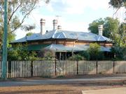
This building, the only one of its type surviving in Coolgardie, is historically significant in being the former residence of the local mining warden. The house is architecturally significant for the way it reflects the purpose for which it was built and for its distinctive design features, some of which later become much more widely used.
A large single house clearly demonstrating the taste and style of an imposing residence of the 1890's. It has stone walls with brick quoins, elaborate joinery to the gables, doors and windows and an iron roof. The building responds to the hot, dry climate with generous protective verandahs on most sides, louvred timber shutters to the full height if the windows and a separate kitchen and ventilated roof lantern.
Constructed for Warden Finnerty, the first warden of Coolgardie (from 1893), who was moved from Southern Cross when the Yilgarn goldfields were superseded by those at Coolgardie.
High
Good
| Name | Type | Year From | Year To |
|---|---|---|---|
| WA Government | Architect | - | - |
| Ref ID No | Ref Name | Ref Source | Ref Date |
|---|---|---|---|
| Webb, M&A "The Centennial History of Kalgoorlie-Boulder" | 1993 |
| Owner | Category |
|---|---|
| National Trust of Australia (WA) | Other Private |
This information is provided voluntarily as a public service. The information provided is made available in good faith and is derived from sources believed to be reliable and accurate. However, the information is provided solely on the basis that readers will be responsible for making their own assessment of the matters discussed herein and are advised to verify all relevant representations, statements and information.
The important architectural character of the building and its historic associations, as well as its now unique existence in Coolgardie.
A large single storied house built be the government to house and important government officer The building demonstrates clearly the taste and imposing residence of the early 1890's - stone walls, brick quoins, generous protective verandahs on most sides, louvred timber shutters to full height windows, elaborate joinery to gable, doors and windows, separated kitchen and the ventilated roof lantern to later become a typical feature of goldfields buildings.
Assessment 1976 Constructed 1894
This information is provided voluntarily as a public service. The information provided is made available in good faith and is derived from sources believed to be reliable and accurate. However, the information is provided solely on the basis that readers will be responsible for making their own assessment of the matters discussed herein and are advised to verify all relevant representations, statements and information.
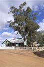
Moran St, 1.5km Nth Coolgardie Coolgardie
Moran St fmr Lefroy St 1.5 km N of Town
Toorak Tank
Coolgardie
Goldfields
Constructed from 1903
| Type | Status | Date | Documents |
|---|---|---|---|
| (no listings) |
| Type | Status | Date | Documents |
|---|---|---|---|
| RHP - To be assessed | Current | 27 Aug 2004 |
| Type | Status | Date | Grading/Management | |
|---|---|---|---|---|
| Category | ||||
| Municipal Inventory | Adopted | 27 Jul 1995 | Category 1 | |
| Classified by the National Trust | Classified | 11 Feb 2002 | ||
16610 Goldfields Water Supply Scheme
The place represents water storage on the Goldfields pipeline.
The place has historical value as it forms part of the Goldfields pipeline.
The place has associations with the establishment of the railway network to the Eastern Goldfields during the gold boom of the 1890s.
The place forms part of system of reservoirs and dams established to provide water for the steam engines that once operated on the railway; a function which is no longer practised.
A large circular reservoir tank into which the Eastern Goldfields Water Supply at first terminated. The tank sits atop Toorak Hill, once the extreme of the gazetted town and the name of its northern suburb and is at a point from which the most extensive and informative views of Coolgardie may be seen.
This place is associated with the Railways but not directly linked. It was a storage tank for the end of the Mundaring to Kalgoorlie pipeline and supplied water to Coolgardie and later Kalgoorlie. ‘At the opening of the Southern Cross to Coolgardie railway on 23 March 1896, Premier Sir John Forrest formally announced his governments intention to construct a water pipeline to Coolgardie. Toorak Hill was chosen as the endpoint of the pipeline as it could provide sufficient fall for the reticulation of the town. By November, Toorak Hill had been surveyed. The plan indicated housing allotments, public reserves, an observatory and a school as well as the tank.’ ‘Even as the water scheme was being implemented Coolgardie was in decline. Alluvial mining was drying up and Kalgoorlie was fast becoming the major Goldfields town. The decision was made that water from the Toorak Tank would be gravity fed a further 40 kilometres to a reservoir to be built on Mt Charlotte at Kalgoorlie and the previously named Coolgardie Water Supply Scheme became the Goldfields Water Supply Scheme.’ ‘Water first flowed into the Toorak Tank on 22 December 1902. At the official opening ceremony the mayor’s wife was first to taste the light brown, less than pleasant tasting water, but at least she had the privilage of doing so from a gold cup.’ ‘By 1912 Toorak Tank was used solely to supply Coolgardies water requirements.’
High
Good - operational and maintained
| Name | Type | Year From | Year To |
|---|---|---|---|
| CY O'Connor | Architect | - | - |
| Library Id | Title | Medium | Year Of Publication |
|---|---|---|---|
| 7351 | Conservation plan for Toorak Hill reservoir : (Goldfields Water Supply Scheme - place V) (draft). | Heritage Study {Cons'n Plan} | 2001 |
Historic site
| Epoch | General | Specific |
|---|---|---|
| Original Use | GOVERNMENTAL | Reservoir or Dam |
| Present Use | GOVERNMENTAL | Reservoir or Dam |
| Type | General | Specific |
|---|---|---|
| Wall | CONCRETE | Other Concrete |
| General | Specific |
|---|---|
| SOCIAL & CIVIC ACTIVITIES | Community services & utilities |
This information is provided voluntarily as a public service. The information provided is made available in good faith and is derived from sources believed to be reliable and accurate. However, the information is provided solely on the basis that readers will be responsible for making their own assessment of the matters discussed herein and are advised to verify all relevant representations, statements and information.
*Toorak Hill Reservoir has great cultural significance for the region and for Western Australia and national significance as a key component of the development of the GWSS. * Toorak Hill Reservoir is highly significant as a key element in the development of the immediate region and the Eastern Goldfields. *Toorak Hill Reservoir is significant for its association with technical innovation and social and political ambition. *Toorak Hill Reservoir is a landmark due to its location and as well known local viewing platform of CooIgardie and the surrounding countryside. *Toorak Hill Reservoir has archaeological and interpretive potential to inform and communicate its significance and thus improve Public understanding of the history, technology and social development of the region and the Goldfields Water Supply.
The Reservoir is located 1.8 kilometres north from Bayley Street, on Toorak Hill overlooking the town of Coolgardie. It is accessed from Moran Street via a gravel track running alongside the old inlet pipe from Bulla Bulling. The track reaches the base of the reservoir bank and then curves to the east winding around the base to finish at the entry gates to the tank. There is a barrier gate located just before the track winds around the base preventing vehicle access. On the east side of the tank is a level cleared area which is host to a large guyed aerial and small cabin. Near the beginning of the vehicle track to the reservoir are the remains of the valve pit (Item 13 on plans attached) where the main from Bulla Bulling, the inlet pipe and the timber bypass joined. Unfortunately this element has been severely damaged although its purpose is still easily read. At the end of the inlet pipe, before it enters the tank, are two valve pits (Item 8 and 9 on the plans attached). The first is a concrete pit containing a valve meant to control water into the tank. The second pit is rock lined and contains a pipe offset and valve, which connects to the break pressure well directly on the southwest (Item 11). Further to the east past the barrier gate is the town supply conduit with a pit and valve to control the flow (items I and 2). Another valve and pit of unknown purpose is close by. The outlet pipe to Kalgoorlie is located on the southeast side of the tank and is marked by a large valve pit structure and valve (Item 5) and a prominent and deep trench (Item 6). A short distance to the south lies the trench for the overflow (item 4). A link mesh cyclone fence surrounds the reservoir. The reservoir (item 3 on plans attached) is a round concrete type with straight sides set into the crown of the hill, approximately 100 metres in circumference (31m in diameter). The spoil from excavation forms a steep earthen bank to the tank. The water gauge is intact and adjacent to an embedded steel rung ladder. The inside surface of the tank is networked with many cracks the majority of which are horizontal. There is evidence of attempts to waterproof the cracking with bituminous material. A large vertical crack on the northwest has been patched with a rubberised material held by a frame. To the north east of the tank is the upstand of the inlet pipe. Besides cracking in the walls the reservoir is in good and intact condition and is still holding water (February 2001). The inlet outlet pipes and control valves are intact and have the appearance of good condition. The town service is also in good condition except for the valve pits, which have deteriorated and are in danger of collapse. A security fence and appropriate signage protect the reservoir from unauthorised entry. The reservoir and its accessories are located in an attractive bushland setting with views to the town and surrounding countryside. There is evidence that the place has been well used in the past as a picnic spot and scenic lookout.
Assessment 2001 Architect/Designer: C Y O'Connor Builder: Public Works Department Construction 1901-1902 Toorak HH1 reservoir was constructed to service the Goldfields Water Supply Scheme, which began official operation in January 1903. This scheme was effectively built to supply fresh water from the coast to a water deficient goldfields and to supply water to regions along its route. The goldfields were established after a number of gold finds in the late nineteenth century in the interior of the state to the east of the Western Australian capital, Perth. The first significant gold discovery was made at Yilgarnin 1887 by HA. Anstey, B.N. Colreavy; N. Higgins and C. Glass. Nearby Southern Cross became the regional cenre fo the prospectors that followed, many of whom travelled from the Kimberley where earlier strikes had recently dried up. After about three years the gold yield started to thin in the Yilgarn region, and prospectors drifted away in search of that elusive strike Using Charles Hunt's earlier records, Arthur Bailey and John Ford travelled over 190 kilometres east of Southern Cross and returned in September 1892 with 554 ounces of gold, discovered at Fly Flat, just east of the present town of Coolgardie. News of the strike coincided with the collapse of the Victorian economy, as well as a global recession, and hopeful prospectors descended upon Coolgardie from all over the world. Most came from'the Eastern Colonies And new Zealand, others came from the United Kingdom, United States, South Africa Afghanistan and (before 1901) China. After landing in Western Australia at either Esperance or Fremantle, those with means went by coach, and later by train, while others traversed the dusty road by bike. Many more carried their worldly possessions in a wheelbarrow and walked the 400 to 500 kilometres. Those who came from Perth travelled the road and sought water from the wells that Charles Hunt had developed thirty years earlier. Once they reached Coolgardie, fresh water was to prove even more elusive than gold. In the initial months of the strike, prospectors had to wait at Southern Cross for news of the water situation before they could continue their journey. Permits were required to travel to Coolgardie and water holes were designated to ensure enough 5supply for the travellers. When rain did fall prospectors would materialise like mushrooms; 300 men appeared in Coolgardie two days after rain fell on 8 March 1893. According to a newspaper article, there were 2,000 men in Coolgardie by June. It is not recorded when women arrived, but it seems that some at least followed their menfolk from the beginning for by 1894 the first government school was established in Coolgardie, with twenty five children being taught the ‘3R's1 in a tent. The average yearly rainfall for Coolgardie is 176.5mm and rain may not fall at all for twelvemonths. In the early years, those who could afford it left Coolgardie for the dry season. The others had to pay between I and 3 shillings per gallon of water, depending on the season. The only sources of water at the time were from either the Raeside, or 35-mile soak, water from condensers, or water carted by train from Northam, then by camel from Southern Cross. Brackish water, which could be used -for household purposes', was produced at the Government shaft about one mile from the town and was sold at 2 pence per gallon." Bores were also sunk for mining purposes. Outside of the town the little rain that did fall was caught in rock catchment areas. This water was more precious than a person's life, as proven when a man was acquitted for shooting an Afghan camel driver because he was washing his feet in a rock hole. No doubt this acquittal had a lot to do with the Typhoid epidemic that was sweeping the area. Typhoid fever was spread through a bacteria called typhoid bacilli that bred in contaminated water in the dams and soaks constructed through the Eastern Goldfields. In the 1890s, Typhoid fever had reached epidemic proportions, not only in Coolgardie, but also in Perth and Northam. Clean, fresh, running water was imperative for the epidemic to be stopped and investment in the place to continue. Even with its depredations and diseases, Coolgardie continued to grow. In 1894, the shanty town of mostly hessian tents got its first (temporary) Post Office and the telegraph was extended from Southern Cross to Coolgardie and then Kalgoorlie" Coolgardie's first and most successful newspaper, The Coolgardie Miner, was published in May. In July, Coolgardie was declared a municipality with the-Coolgardie Municipal Council being elected in December.14 In the space of two years, Coolgardie had become a substantial town. By 1898 Coolgardie had reached its zenith of development with a population of 15,000 in the town boundaries and another 10,000 in the surrounding countryside. This was without a permanent water supply. The severe lack of water on the goldfields for human and animal consumption and for gold production was to be addressed by the Coolgardie Water Supply Scheme. This scheme collected water in a weir in the Helena Valley and pumped it to the goldfields using 8 steam driven pumping stations strategically located along the length of the pipe track. The original scheme was to pump the water to Coolgardie and into the Toorak tank as the terminus of the pipe. However by 1898 the alluvial gold was drying up and prospectors had moved on to the more popular fields at Kalgoorlie where gold had been discovered in 1893. In the light of the rapid development of Kalgoorlie it was decided, during the course of pipeline construction, to extend the supply 38.5 kilometres to terminate in another reservoir at Mt Charlotte in the KaIgoorIie fields. " The name of the project was accordingly changed to the GWSS. The new purpose of the Toorak tank was to supply the town of Coolgardie and to gravity feed water to the reservoir at Mount Charlotte. Water was gravity fed to the Toorak tank from the large reservoir at Bullabulling that was in turn serviced from No 6 Pump Station at Dedari. Excavation of the Toorak Hill Reservoir started in 1900 and was completed in 1901.16 The last 24 miles (38.4kms) of trench to Toorak Hill was excavated during 1902.17 Water reached the reservoir on 22 December 1902 after taking 10 months to travel the 525 kilometres from Mundaring Weir. At the Coolgardie opening ceremony in January 1903, the Mayor's wife had the dubious honour of the first drink of water from the scheme out of a solid gold cup The water was lightish brown in colour and it had a less than pleasant taste caused by the tar used in joining the pipes. However by now the town had lost most of its population and the suburb of Toorak Hill was deserted By 1904 the population had plummeted to 4,000. For those remaining residents, water now cost 7s per 1000 gallons, a big saving from 15s per 100 gallons of condensed water. On the recommendation of the 1909 report on the corrosion of the main steel conduit it was decided to replace and enlarge the existing bypass pipe around Toorak Hill.21 This pipe provided a bypass route for water enroute from Bullabulling to Mt Charlotte in case the tank was unserviceable. After much deliberation an Oregon timber bypass conduit supplied by the Australian Timber Pipe Company was laid in 1911 around the base of the hill (see attached plans). After the initial problems, the wood bypass pipe seemed to have proven adequate to the task for it was still in use in 1939 and appeared likely to last another five years at least Co incidentally, it was about this time that Karri timber stave pipe was being used on some sections of the main pipeline as a replacement for the original steel pipe. During the 1980s a new steel pipe bypass was laid, mostly above the ground. Unfortunately cracks in the concrete walls and floor were a major problem during the service life of the reservoir. Many treatments were tried but none had complete success. In 1944 the largest crack was covered with a large rubber sheet held by a steel frame. However even these measures appear to have been less than successful. From the mid 1980s the reservoir was used only as a temporary town service during shutdowns and was eventually taken out of all service as the towns supply now came directly from the main conduit. Toorak Hill Toorak Hill was always a popular picnic spot, as it affords the best views of CooIgardie. When the train from Kalgoorlie ran every Sunday, day trippers would climb the hill to enjoy the day on the reserve south of the reservoir. Although the tank was fenced off, this did not stop the local children from swimming in it. The place was recorded as a Historic Site by the National Trust on 27 October 1976. It is listed on Coolgardie's Municipal Inventory with a Category 1 and is on the Shire of CooIgardie's Town Planning Scheme
This information is provided voluntarily as a public service. The information provided is made available in good faith and is derived from sources believed to be reliable and accurate. However, the information is provided solely on the basis that readers will be responsible for making their own assessment of the matters discussed herein and are advised to verify all relevant representations, statements and information.
Constructed from 1903
The ruins off to the sides of the reservoir and the reservoir itself are significant due to their industrial, archaeological and social significance. The site itself has great aesthetic importance.
A large circular reservoir tank into which the Eastern Goldfields Water Supply at first terminated. The tank sits atop Toorak Hill, once the extreme of the gazetted town and the name of its northern suburb, and it is at a point from which the most extensive and informative views of Coolgardie can be seen.
The tank is associated with the epic feat of the construction of the Eastern Goldfields Water Supply, one of the State's most important and ambitious undertakings.
High
Fair
| Ref ID No | Ref Name | Ref Source | Ref Date |
|---|---|---|---|
| Webb, M&A "The Centennial History of Kalgoorlie-Boulder" | 1993 |
| Owner | Category |
|---|---|
| Water Authority of Western Australia | State Gov't |
This information is provided voluntarily as a public service. The information provided is made available in good faith and is derived from sources believed to be reliable and accurate. However, the information is provided solely on the basis that readers will be responsible for making their own assessment of the matters discussed herein and are advised to verify all relevant representations, statements and information.
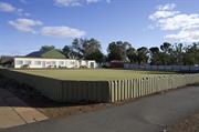
Cnr Sylvester & Lefroy Sts Coolgardie
Adj Town Hall
Exhibition stand
Coolgardie
Goldfields
Constructed from 1899 to 1907
| Type | Status | Date | Documents |
|---|---|---|---|
| State Register | Registered | 14 Feb 2003 | HCWebsite.Listing+ListingDocument, HCWebsite.Listing+ListingDocument |
| Type | Status | Date | Documents |
|---|---|---|---|
| (no listings) |
| Type | Status | Date | Grading/Management | |
|---|---|---|---|---|
| Category | ||||
| Municipal Inventory | Adopted | 27 Jul 1995 | Category 2 | |
| Register of the National Estate | Registered | 21 Mar 1978 | ||
| Classified by the National Trust | Classified | 10 Sep 2001 | ||
| Library Id | Title | Medium | Year Of Publication |
|---|---|---|---|
| 5117 | Coolgardie Bowling Pavilion : conservation plan. | Heritage Study {Cons'n Plan} | 2001 |
Individual Building or Group
| Epoch | General | Specific |
|---|---|---|
| Present Use | SOCIAL\RECREATIONAL | Other Sports Building |
| Original Use | SOCIAL\RECREATIONAL | Other Community Hall\Centre |
| Style |
|---|
| Federation Filigree |
| Type | General | Specific |
|---|---|---|
| Roof | METAL | Corrugated Iron |
| Wall | TIMBER | Other Timber |
This information is provided voluntarily as a public service. The information provided is made available in good faith and is derived from sources believed to be reliable and accurate. However, the information is provided solely on the basis that readers will be responsible for making their own assessment of the matters discussed herein and are advised to verify all relevant representations, statements and information.
Constructed from 1899
Significant for its architectural construction and interest.
A small timber framed structure clad in mini-orb and painted. Deep eaves bracketed of walls and a fascia decorated with a scalloped edge. The roof is a concave curve and would have had a decorative finial, since lost.
One of the only structures built for sporting/recreation activities left from the Gold Boom period. The building had its origins in the Exhibition of 1899 when it was reputedly brought from France as an exhibition stand. In 1903 it became the property of the bowling club.
Moderate-High
Fair
| Ref ID No | Ref Name | Ref Source | Ref Date |
|---|---|---|---|
| Webb, M&A "The Centennial History of Kalgoorlie-Boulder" | 1993 |
| Owner | Category |
|---|---|
| Shire of Coolgardie | Local Gov't |
This information is provided voluntarily as a public service. The information provided is made available in good faith and is derived from sources believed to be reliable and accurate. However, the information is provided solely on the basis that readers will be responsible for making their own assessment of the matters discussed herein and are advised to verify all relevant representations, statements and information.
Coolgardie Bowling Club has cultural significance for the following reasons: The place is a fine example of a small scale timber structure in the Federation Filigree style. The structure has a simple form with strong charm and as a result achieved a high level of aesthetic value. The place is associated with the WA Mining and Industrial Exhibition held in Coolgardie from 21 March 1899 to 1 July 1899 and is the only intact structure to still exist from the Exhibition. The place is associated with the establishment of the Coolgardie Bowling Clun in 1907. From 1907 up to the mid to late 1970’s, the Coolgardie Bowling Pavilion served as the clubrooms for this sporting organisation and still remains on the bowling club site in 2001. AESTHETIC Y ALUE Coolgardie Bowling Pavilion is a fine example of a small scale timber structure in the Federation Filigree style. The structure has a simple form with strong charm and as a result achieved a high level of aesthetic value. (Criterion 1 .1) The small scale and hipped concave roof of Coolgardie Bowling Pavilion are two characteristics contributing to it picturesque quality which adds to the townscape value of the historic town , which is one of eight historic towns designated by the National Trust of WA. (Criteria I.I & 1.4) HISTORIC VALUE The place is associated with the discovery of gold near Coolgardie by Bayley and Ford in 1892, the declaration of the field in 1892, and the subsequent mass migration to this area by people eager to strike a claim of their own. The discovery of gold and the burgeoning_town at Coolgardie signalled the further exploration and .settlement of the remainder of what became kown as the Eastern Goldfields area. (Criteria 2.1 & 2.2) The place is associated with the WA Mining and Industrial Exhibit ion held in Coolgardie from 21 March 1899 to I July 1899; the primary purpose of which was firstly to promote interest in the mining industry of the Eastern Goldfields and secondly, Western Australian industry as a whole. Local history has it that the Coolgardie Bowling Pavilion was part of an exh ibit that originated from Europe. (Criterion 2.2) The place is associated with Coolgardie's development as the mining, business and administrative centre of the Eastern Goldfields and is representative of the growth of social and recreational activities and facilities. ln particular, the place is associated with the establishment of the Coolgardie Bowling Club in 1907. From 1907 up to the mid to late 1970s, the Coolgardie Bowling Pavilion served as the clubrooms for this sporting organisation. (Criterion 2.2) The place has associations with the Coolgardie Bowling Club which was established in 1907 and continues to operate in 200 I. (Criterion 2.3) SOCIAL VALUE The place has social significance to the Coolgardie community and contributes to this communities ' sense of place, due to its associations with the WA Mining and Industrial Exhibition in 1899 and its long association with the Coolgardie Bowling Club dating from 1907. (Criteria 4.1 & 4.2) The listing by The National Trust of Australia (WA) and the inclusion of the p lace in the Shire of Coolgardie's Municipal Inventory are also a measure of social significance. Coolgardie is one of eight historic towns designated by the National Trust in Western Australia . (Criterion 4.2) RARlTY Coolgardie B owling Pavilion has rarity value as the only intact structure from the 1899 Western Australian Mining and Industrial Exhibition. (Criterion 5.1) Coolgardie Bowling Pavilion has rarity as one of a small number of small kiosk structures in Western Austra lia. (Criterion 5.2) REPRESENT ATIVENESS Coolgardie Bowling Pavilion is a rare example of a small timber kiosk purpose built for an exhibition in the late 1880s. (Criterion 6. 1) The ornate, rather than utilitarian, design of the kiosk is representative of the opulent nature and architecture of the Coolgardie gold boom. (Criterion 6.1) COND ITION The place is in poor condition, primarily due to its lack of substructure and support, including Jack of wind bracing, a lack of consistent maintenance, and poor repairs. INTEGRITY The place has a moderate degree of integrity. AUTHENTIC ITY The authenticity of the pavilion is moderate to high.
The Coolgardie Bowling Pavilion is a small timber framed rectagular structure located within the Coolgardie Bowling Club site and positioned on a narrow gr ass strip to the west side of the bowling green. The Bowling Club is situated on the comer of Sylvester and Lefroy Streets with Coolgardie Park bordering the west boundary. The Coolgardie Bowling Pavilion , a small scale example of a timber structure in the Federation Filigree style of architecture, has a simple form and strong charm. The walls are constructed of exposed timber frame, with ripple iron and plain galvanised iron panels fixed with galvanised flat head nails. The sheets are further secured with timber beading (quads) around each panel. Original studs and frame members are western red cedar. Many of the original western red cedar studs have been replaced with sawn jarrah studs and most of th e beads are also replacement. The original timber skirting consists of a chamfered plate and this is extant on the north , south and west elevations. The entire exterior has been painted . The east elevation faces the bowling green and provides access to the interior. The elevation has been modified to include large ripple iron and timber braced double swing doors, which are not centred and are poorly constructed. (This is the most significant alteration to the original structure.) The door on the north elevation has been covered over with ripple iron and is no longer in use. This elevation now has the same appearance as the south elevation. The west elevation contains two ripple iron and timber braced hatches , which are no longer in use. The timber framed roof is hipped with a concave profile and is clad in ripple iron with a plain galvanised iron rolled ridge. The roof has been painted in candy stripes. The soffit lining consists of 6" tongue and groove Oregon boards and the roof overhang is supported by moulded timber brackets, fixed to the exposed wall studs and corner posts. The pavilion retains sections of original fascia panel, which is moulded with a scalloped motif, as well as section s of original cast iron gutter. The interior consists of one single space. The floor is constructed of 6" x 1" Oregon floorboards, with a 4" reed moulded skirting. The wall and ceiling lining consists of vertical 4" and horizontal 6" (respectively) western red cedar v-jointed tongue and groove boards. (Some of the lining on the west and east walls is either damaged or missing.) The ceiling is hipped at thirty degrees and there is one timber boss extant (one is missing), which would have been a continuation of the cast iron finial panel (now removed). There are iron coat hooks fixed to a horizontal timber rail that runs above the height of the hatches on the north, south and west walls. There is also a timber ladder on the south wall of the interior, which was custom made for the pavilion and used for the storage of bowling equipment. The pavilion is in poor condition due to the removal of its substructure and lack of wind bracing. The timber bearers of the pavilion do not appear to be original and lay only on the ground. Its lack of substructure and wind bracing, together with the introduction of the double doors on the east elevation, has contributed to the racking of the pavilion towards the south and west ends. Although the Coolgardie Bowling Pavilion is in poor condition and several original elements have either been replaced or altered , the structure 's form is little changed from its original construction.
Assessment 2001\Construction 1899 Alterations/additions: 1901; 1907; mid to late 1970's The idea for a mining exhibition was first raised by the Coolgardie Mine Managers' Institute in the mid 1 890s, primarily to show the technologies that had developed in response to the mining of lowgrade ores in Western Australia. Due to widespread approval and interest in the project, it was eventually decided that the exhibition should not only be concerned with mining but also take into account the State's primary industries as a whole. It subsequently became known as the Western Australian Mining and Industrial Exhibition. The Western Australian Mining and Industrial Exhibition was officially opened on 21 March 1899 by His Excellency Governor Sir Gerald Smith. Local history has it that the kiosk (Coolgardie Bowling Pavilion) was part of an exhibition originating from Europe. A photograph of the Exhibition in 1899 shows the kiosk (Coolgardie Bowling Pavilion). (The Western Australian Mining and Industrial Exhibition was officially closed on 1July 1899 having attracted approximately 61,158 people through its doors and to the Eastern Goldfields.) A plan of the West Australian Exhibition at Coolgardie dated I 900- I 902 shows the buildings on site including the kiosk (Coolgardie Bowling Pavilion) located in the north-we stern corner of the quadrangle. The purpose of this plan was to show the building s, structures and materials that were to be removed from the site, prior to its conversion as a school of mines and, on 12 January 1900, a contract was offered for the purchase and removal of certain structures at the exhibition buildings at Coolgardie. Nothing happened at this time and tenders were again offered for this contract on 24 May 1901. The contract was eventually awarded to J. Crothers on 8 July 190I for his cost of £650/-. · - --=-- - With the continued consolidation of the Coolgardie townsite in the late 1890s and 1900s came the establishment of social and recreational activities and organisations. From 1904 to 1905, steps were taken by the Coolgardie Council towards the making of a bowling green in Coolgardie. The development of the Coolgardie bowling green had reached the stage that on 12 January 1907 the 'recently formed' Coolgardie Bowling Club was able to have its first practice session proper on 9 February 1907, Mayor of Coolgardie Mr A. Mercer officially opened the Coolgardie bowling green. Photographs of the opening day show that the pavilion was at the green at this time. Research by H. Ware reportedly found that former Coolgardie Mayor W. Strother had purchased the structure and it was he who later installed it at the Coolgardie Bowling Club. From 1907 to the mid to late 1970s, the Coolgardie Bowling Pavilion (former kiosk) served as the official bowling clubhouse. It was used for club meetings and activities, and also housed the club's equipment. Special ladders were constructed and placed inside the pavilion to store the bowls. One of these ladders is still extant- In the mid to late 1970s, the Coolgardie Bowling Pavilion was relocated to its current position at the western side of the green. This was done as a result of the erection of a new headquarters for the bowling club as well as the extension of the bowling green. Since this time (an up to 2001), the Coolgardie Bowling Pavilion has been used for storage purposes.
This information is provided voluntarily as a public service. The information provided is made available in good faith and is derived from sources believed to be reliable and accurate. However, the information is provided solely on the basis that readers will be responsible for making their own assessment of the matters discussed herein and are advised to verify all relevant representations, statements and information.