Local Government
Cuballing
Region
Wheatbelt
Cuballing
Cuballing
Wheatbelt
| Type | Status | Date | Documents |
|---|---|---|---|
| (no listings) |
| Type | Status | Date | Documents |
|---|---|---|---|
| (no listings) |
| Type | Status | Date | Grading/Management | |
|---|---|---|---|---|
| Category | ||||
| Municipal Inventory | Adopted | 30 Sep 1996 | ||
Historic site
| Epoch | General | Specific |
|---|---|---|
| Present Use | Transport\Communications | Road: Other |
| Original Use | Transport\Communications | Road: Other |
| Type | General | Specific |
|---|---|---|
| Other | TIMBER | Other Timber |
| General | Specific |
|---|---|
| TRANSPORT & COMMUNICATIONS | Droving |
This information is provided voluntarily as a public service. The information provided is made available in good faith and is derived from sources believed to be reliable and accurate. However, the information is provided solely on the basis that readers will be responsible for making their own assessment of the matters discussed herein and are advised to verify all relevant representations, statements and information.
The place has historic value as a reminder of the importance, to early settlers, of regular water supplies along well travelled routes.
The well is iocated in the road reserve. The well is timber lined and is approximately 500 mm wide, 1200 mm long and 2 metres deep.
A reliable water source was very important to early settlers and travellers. As a result wells were often sunk along well travelled routes to provide people, and their stock, with water.
INTEGRITY: High Degree AUTHENTICITY: High Degree
Good
This information is provided voluntarily as a public service. The information provided is made available in good faith and is derived from sources believed to be reliable and accurate. However, the information is provided solely on the basis that readers will be responsible for making their own assessment of the matters discussed herein and are advised to verify all relevant representations, statements and information.
Cuballing
Cuballing
Wheatbelt
Constructed from 1932
| Type | Status | Date | Documents |
|---|---|---|---|
| (no listings) |
| Type | Status | Date | Documents |
|---|---|---|---|
| (no listings) |
| Type | Status | Date | Grading/Management | |
|---|---|---|---|---|
| Category | ||||
| Municipal Inventory | Adopted | 30 Sep 1996 | 4 | |
Historic Site
| Epoch | General | Specific |
|---|---|---|
| Original Use | EDUCATIONAL | Primary School |
| Present Use | EDUCATIONAL | Primary School |
| General | Specific |
|---|---|
| SOCIAL & CIVIC ACTIVITIES | Education & science |
This information is provided voluntarily as a public service. The information provided is made available in good faith and is derived from sources believed to be reliable and accurate. However, the information is provided solely on the basis that readers will be responsible for making their own assessment of the matters discussed herein and are advised to verify all relevant representations, statements and information.
Constructed from 1931
The site is a reminder of the early development of the district, when small settlements developed and schools were required due to the sufficient number of children, and then declined as enrolments fluctuated as Cuballing, and then Pingelly and Narrogin, became the major service centres for the district.
Mr E. Modra approached the local MLA on 26 June 1918 requesting his help in establishing a school in the region east of Cubailing. After further correspondence, it was reported that the proposed site for the school was on reserve No. 15462, nine miles east of Cubailing. However, the application was not successful and the school did not go ahead at this time. Another attempt was made to establish a school in 1921. Eventually the Public Works Department arranged for the removal of the Gnorlarling Soak school to Commodine at a cost of £18717/-. On 13 March 1932, the school was ready and officially opened by the teacher. The school was shortlived, closing in 1936 due to low enrolments. Mr W. F. Watts applied to purchase the school on 7 September 1938 and on 4 October it was sold to him for £17/10/-.
Site only
| Owner | Category |
|---|---|
| Shire of Cuballing | Local Gov't |
This information is provided voluntarily as a public service. The information provided is made available in good faith and is derived from sources believed to be reliable and accurate. However, the information is provided solely on the basis that readers will be responsible for making their own assessment of the matters discussed herein and are advised to verify all relevant representations, statements and information.
Cuballing
Cuballing
Wheatbelt
Constructed from 1991
| Type | Status | Date | Documents |
|---|---|---|---|
| (no listings) |
| Type | Status | Date | Documents |
|---|---|---|---|
| (no listings) |
| Type | Status | Date | Grading/Management | |
|---|---|---|---|---|
| Category | ||||
| Municipal Inventory | Adopted | 30 Sep 1996 | 4 | |
Historic Site
| Epoch | General | Specific |
|---|---|---|
| Original Use | SOCIAL\RECREATIONAL | Other |
| Present Use | SOCIAL\RECREATIONAL | Other |
| General | Specific |
|---|---|
| SOCIAL & CIVIC ACTIVITIES | Sport, recreation & entertainment |
This information is provided voluntarily as a public service. The information provided is made available in good faith and is derived from sources believed to be reliable and accurate. However, the information is provided solely on the basis that readers will be responsible for making their own assessment of the matters discussed herein and are advised to verify all relevant representations, statements and information.
Constructed from 1908
The site has historic value as a reminder of the early develojWent of the district.
A plaque commemorates the tennis dub site.
Tennis Club existed from 1908 - 1990. Not a lot is known about the earty days of tennis in Cuballing area. Tennis was played at Nebrikinning School, and on a private court on the Metzke's farm. From 1908, players from the eastern side of the district gravitated to the courts at Commodine.
Site only
| Owner | Category |
|---|---|
| Shire of Cuballing | Local Gov't |
This information is provided voluntarily as a public service. The information provided is made available in good faith and is derived from sources believed to be reliable and accurate. However, the information is provided solely on the basis that readers will be responsible for making their own assessment of the matters discussed herein and are advised to verify all relevant representations, statements and information.
Alton St Cuballing
in railway reserve north of Alton Street
Cuballing
Wheatbelt
Constructed from 1921
| Type | Status | Date | Documents |
|---|---|---|---|
| (no listings) |
| Type | Status | Date | Documents |
|---|---|---|---|
| (no listings) |
| Type | Status | Date | Grading/Management | |
|---|---|---|---|---|
| Category | ||||
| Statewide War Memorial Survey | Completed | 01 May 1996 | ||
| Municipal Inventory | Adopted | 30 Sep 1996 | 5 | |
Historic site
| Epoch | General | Specific |
|---|---|---|
| Original Use | MONUMENT\CEMETERY | Monument |
| Present Use | MONUMENT\CEMETERY | Monument |
| Type | General | Specific |
|---|---|---|
| Other | STONE | Marble |
| General | Specific |
|---|---|
| OUTSIDE INFLUENCES | World Wars & other wars |
This information is provided voluntarily as a public service. The information provided is made available in good faith and is derived from sources believed to be reliable and accurate. However, the information is provided solely on the basis that readers will be responsible for making their own assessment of the matters discussed herein and are advised to verify all relevant representations, statements and information.
Constructed from 1921
The War Memorial has social value for the local community commemorating those local citizens who participated in each World War.
The memorial is sited in a iawned and landscaped setting. The area is bounded by a timber slat fence. The memorial comprises a single pier made up of a plinth of three graduating, rock-faced stone blocks surmounted by a marble pedestal which is crowned with a rock-faced spire. The marble pedestal is Inscribed with names. The memorial commemorates those from Cubaliing and YGrnanlng who died during the Great War of 1914-1918.
In 1921 in Cuballing, a War Memorial, standing 20 feet high and constructed of blue granite, was unveiled by Dr Mackie. Over 300 people travelled on a train from Narrogin to attend the ceremony.1
INTEGRITY: High Degree AUTHENTICITY: High Degree
Mostly Sound
| Ref ID No | Ref Name | Ref Source | Ref Date |
|---|---|---|---|
| 'Cuballing Heritage Trail' | Shire of Cuballing, | ||
| "Reunion 1990: A Cuballing Keepsake CCuballing," | 1990 |
| Owner | Category |
|---|---|
| Shire of Cuballing | Local Gov't |
This information is provided voluntarily as a public service. The information provided is made available in good faith and is derived from sources believed to be reliable and accurate. However, the information is provided solely on the basis that readers will be responsible for making their own assessment of the matters discussed herein and are advised to verify all relevant representations, statements and information.

Alton St Cuballing
now Uniting Church
Cuballing
Wheatbelt
Constructed from 1904
| Type | Status | Date | Documents |
|---|---|---|---|
| (no listings) |
| Type | Status | Date | Documents |
|---|---|---|---|
| RHP - Does not warrant assessment | Current | 25 Jun 2004 |
| Type | Status | Date | Grading/Management | |
|---|---|---|---|---|
| Category | ||||
| Uniting Church Inventory | Completed | 01 Oct 1996 | ||
| Municipal Inventory | Adopted | 30 Sep 1996 | 3 | |
Individual Building or Group
| Epoch | General | Specific |
|---|---|---|
| Present Use | RELIGIOUS | Church, Cathedral or Chapel |
| Original Use | RELIGIOUS | Church, Cathedral or Chapel |
| Style |
|---|
| Federation Gothic |
| Type | General | Specific |
|---|---|---|
| Wall | BRICK | Common Brick |
| Roof | METAL | Corrugated Iron |
| General | Specific |
|---|---|
| SOCIAL & CIVIC ACTIVITIES | Religion |
This information is provided voluntarily as a public service. The information provided is made available in good faith and is derived from sources believed to be reliable and accurate. However, the information is provided solely on the basis that readers will be responsible for making their own assessment of the matters discussed herein and are advised to verify all relevant representations, statements and information.
Constructed from 1904
The building is a representative example of a simplified interpretation of the Federation Gothic style. The Church is a demonstration of the development that occurred in Cuballing around the turn-of-the-century as it became the service centre of the district.
The building is intimate in scale, with a steeply-pitched gabie roof, and is conventionally orientated east-west The building has an entry porch at the street elevation (east)". The building has a high-pitched roof which is devoid of any decoration with the exception of timber barge boards and simple timber fret work in the gable ends. The porch is also covered by a gabie roof that has a timber bargeboard. The porch has a lancet shaped door opening with a timber panelled door. The brick walis are iaid in colonial bond and are strengthened with stepped buttresses. The nave consists of six lancets, three either side, divided into four panes with a combination of thickened patterned glass and etched glass. Lancets also feature on the east elevation, one either side of the porch. The interior of the building is austere. The walls are rendered and the timber floors boards have been covered with carpet. A new ceiling has been installed with suspended fluorescent lights. A lined, timber framed addition extends across the rear elevation (west) with a lean-to roof. A separate W.C. is at the rear of the site.
Formerly the Methodist Church, this building was constructed in 1904. Two foundation stones were laid, one by the Moderator of the Methodist Church and the other by Frederick Rose, Chairman of the Cuballing Roads Board.
INTEGRITY: High Degree AUTHENTICITY: High Degree
Good
| Ref ID No | Ref Name | Ref Source | Ref Date |
|---|---|---|---|
| "Cuballing Heritage Trail". | Shire of Cuballing | ||
| Apperly, R., Irving, R., Reynolds, P., A; "Pictorial Guide to Identifying Australian Architecture: Styles and Terms from 1788 to the Present". | Angus & Robertson, Sydney, | 1994 |
| Owner | Category |
|---|---|
| Uniting Church in Australia | Church Property |
This information is provided voluntarily as a public service. The information provided is made available in good faith and is derived from sources believed to be reliable and accurate. However, the information is provided solely on the basis that readers will be responsible for making their own assessment of the matters discussed herein and are advised to verify all relevant representations, statements and information.

71 Alton St Cuballing
Cuballing
Wheatbelt
Constructed from 1912, Constructed from 1896
| Type | Status | Date | Documents |
|---|---|---|---|
| (no listings) |
| Type | Status | Date | Documents |
|---|---|---|---|
| (no listings) |
| Type | Status | Date | Grading/Management | |
|---|---|---|---|---|
| Category | ||||
| Municipal Inventory | Adopted | 30 Sep 1996 | 2 | |
| Statewide Hotel Survey | Completed | 01 Nov 1997 | ||
| Name | Type | Year From | Year To |
|---|---|---|---|
| B.H. Dodds | Architect | - | - |
Individual Building or Group
| Epoch | General | Specific |
|---|---|---|
| Present Use | COMMERCIAL | Hotel, Tavern or Inn |
| Original Use | COMMERCIAL | Hotel, Tavern or Inn |
| Style |
|---|
| Federation Filigree |
| Type | General | Specific |
|---|---|---|
| Wall | BRICK | Common Brick |
| Roof | TILE | Terracotta Tile |
| Other | RENDER | Other Render |
| General | Specific |
|---|---|
| OCCUPATIONS | Hospitality industry & tourism |
This information is provided voluntarily as a public service. The information provided is made available in good faith and is derived from sources believed to be reliable and accurate. However, the information is provided solely on the basis that readers will be responsible for making their own assessment of the matters discussed herein and are advised to verify all relevant representations, statements and information.
Constructed from 1896, Constructed from 1912
The original building with its second storey addition, is representative of the Australian Pub tradition as a two storey hotel with a verandah that extends over the pavement as a dominant streetscape element. The place has historic significance as part of a building boom that occurred around 1912 as Cuballing established itself as a progressive town with the facilities to support it.
The two-storey building is constructed to the building line of Alton Street and faces the raiiway line. The building was constructed in two stages. The ground floor was constructed in c.1896. with a pedimented ™ parapet. The parapet was removed and the second storey added in 1912. The building is built in the Federation Filigree style. The exterior wails are built of local bricks and are laid in English bond, now painted to the lower level, and Colonial bend to the upper level. The brickwork on the street elevation is tuck-pointed. The roof has tail rendered brick chimneys, and features two elaborate pediments that bear the name of the place and date of the construction cf the upper level. Rendered bands, which have been painted over, run the length of the front elevation . A concrete verandah and balcony extend across the street elevation over the footpath. The balcony is supported on square timber posts on rendered brick bases that are paired at either end of the verandah. The posts with decorative timber brackets, divide the elevation into bays. Openings are elliptical arches with curved sashes. The window frames are heavily recessed behind the outer face of the building. Some window panes have been altered. Six French doors, with rectangular fanlights, open onto the balcony. The main entry doors lead to another pair inside, forming a vestibule. The outer doors are narrow panelled doors with leaded and stained glass panels. The inner doors have etched glass panels with leaded and stained glass fanlights. The floor of the entrance is linoleum covered floorboards. The interior of the hotel comprises bar and dining facilities Gn the lower level, and accommodation on the upper level. The interior features highly decorative pressed metal ceilings and cornices, a carved timber stair, and simple arches on the upper level. Over the years, a series of brick outbuildings have been constructed to the rear of the hotel. The buildings now link to the main hotel by a covered way. Circa 1990, a patio was added to the south elevation which is covered by a pergola clad in sheet metal. Circa. 1993, an apartment was added to the rear. Further works include the refurbishing of the upper level, including laying of floor coverings and ceiling replacement. A secondary entrance off Alton Street has been bricked-up.
The ground floor was constructed in c.1896 and the upper storey was added later in 1912. The decision to carry out additions and the progress of construction can be followed in the regional newspaper, the Great Southern Leader. "In addition to other buildings, the Hotel Cuballing is about to be rebuilt at a cost of several thousands."1 "New building operations in the town are going on apace. A contract has been let for the building of the new Agricultural Hall, and this building, together with the new Post Office, and the spacious additions to the Hotel Cuballing, the handsome new Anglican Church just recently completed, and the spacious hall erected by Mr Reynolds, will give the town a decidedly more imposing appearance".2 ".. .the additions of the Hotel Cuballing are also seriously contemplated".3 "Tenders are invited by Mr. B. H. Dods, architect and quantity surveyor, for the erection and completion of extensive alterations and additions to the Hotel Cuballing for Mr. E. Edmeades, of Northam. Tenders close June 11". 4 "The alterations and additions to the local hotel are being preceded with, and when completed this building will be one of the most imposing on this line".5 "The Hall and post office should soon be completed edifices. The 'pub' is also being pushed on..."6 Unfortunately, there is no report in the newspaper about the completion of the additions.
INTEGRITY: Moderate to High Degree AUTHENTICITY: Moderate Degree
| Ref ID No | Ref Name | Ref Source | Ref Date |
|---|---|---|---|
| 'Cuballing Heritage Trail' | Shire of Cuballing, | ||
| "Great Southern Leader,".p 3 | 19 January 1912, | ||
| Apperly, R., Irving, R., Reynolds, P; "A Pictorial Guide to Identifying Australian Architecture: Styles and Terms from 1788 to the Present". pp 108-111 | Angus & Robertson, Sydney, | 1994 |
| Owner | Category |
|---|---|
| P & F Paterson | Other Private |
This information is provided voluntarily as a public service. The information provided is made available in good faith and is derived from sources believed to be reliable and accurate. However, the information is provided solely on the basis that readers will be responsible for making their own assessment of the matters discussed herein and are advised to verify all relevant representations, statements and information.

83-89 Alton St Cuballing
Cnr Campbell & Alton Sts
Western Australian Bank
Cuballing
Wheatbelt
Constructed from 1890
| Type | Status | Date | Documents |
|---|---|---|---|
| (no listings) |
| Type | Status | Date | Documents |
|---|---|---|---|
| (no listings) |
| Type | Status | Date | Grading/Management | |
|---|---|---|---|---|
| Category | ||||
| Statewide Bank Survey | Completed | 01 Nov 1997 | ||
| Municipal Inventory | Adopted | 30 Sep 1996 | 3 | |
Individual Building or Group
| Epoch | General | Specific |
|---|---|---|
| Original Use | COMMERCIAL | Bank |
| Present Use | RESIDENTIAL | Single storey residence |
| Original Use | RESIDENTIAL | Conjoined residence |
| Type | General | Specific |
|---|---|---|
| Wall | BRICK | Common Brick |
| Roof | METAL | Corrugated Iron |
| General | Specific |
|---|---|
| OCCUPATIONS | Commercial & service industries |
This information is provided voluntarily as a public service. The information provided is made available in good faith and is derived from sources believed to be reliable and accurate. However, the information is provided solely on the basis that readers will be responsible for making their own assessment of the matters discussed herein and are advised to verify all relevant representations, statements and information.
Constructed from 1900
The former Western Australian Bank building shares the intersection with the former Post Office on what was an important civic and commercial area in Cuballing. The two buildings form a group that are a representative reminders of commerce in Cuballing.
The building is built to the building line on the south-western corner of Campbeil and Alton Streets, with a truncated corner that once formed the public entry. The building shares the intersection with the former Post Office. This intersection with the two buildings are remnants that mark an old commercial precinct of Cuballing. The roof features a tall corbelled brick chimney with terra-cotta potted tops, timber battened eaves, and a triangular pediment that crowns the building's truncation, giving emphasis to the building's entrance. The pediment has a halt timber effect, barge board and afiniai. The building bears the name, 'Western Australian Bank'. The building is symmetrical about the entrance with a wide window with flattened arched fanlight, either side of the entrance. The windows have rendered decorative surrounds and sills. A residence was built along the Alton Street elevation that is set back from the street alignment. The verandah extends across the residence and abuts the bank building. The residence and bank have back to back chimneys. The interior of the bank is comprised of a single room, no physical evidence remains of its original purpose. The exterior of the residence features double-hung sash windows with side lights, and a grand entry door with side lights and leaded and stained glass fanlights. The interior of the residence retains simple arches supported on pilasters, pressed metal ceilings, decorative ceiling roses, cornices and skirtings. C. 1950s, while the bank building was then operating for use as a delicatessen, a wide opening was made in the south wall of the bank building allowing public access to the dali from the verandah of the residence. The opening has been brick-up but is evident. A timber framed and lined enclosure with a lean-to roof now obscures the verandah. The residence has been further extended down the south elevation that once formed a laneway to the rear, and at the rear. The additions have lean-to roofs. The exterior of the entire building has been rendered. The original entrance door way has been replaced by a window and now accommodates a bedroom.
The building was believed to have been constructed at the tum-of-the-century by James Fitt using local bricks and was constructed for use as a bank.
INTEGRITY: Moderate Degree AUTHENTICITY Low to Moderate Degree
| Ref ID No | Ref Name | Ref Source | Ref Date |
|---|---|---|---|
| 'Cuballing Heritage Trail' | Shire of Cuballing |
| Owner | Category |
|---|---|
| H. A. Wrankmore | Other Private |
This information is provided voluntarily as a public service. The information provided is made available in good faith and is derived from sources believed to be reliable and accurate. However, the information is provided solely on the basis that readers will be responsible for making their own assessment of the matters discussed herein and are advised to verify all relevant representations, statements and information.
19 Beeston St Cuballing
Cuballing
Wheatbelt
Constructed from 1895
| Type | Status | Date | Documents |
|---|---|---|---|
| (no listings) |
| Type | Status | Date | Documents |
|---|---|---|---|
| (no listings) |
| Type | Status | Date | Grading/Management | |
|---|---|---|---|---|
| Category | ||||
| Municipal Inventory | Adopted | 30 Sep 1996 | 4 | |
Historic Site
| Epoch | General | Specific |
|---|---|---|
| Present Use | EDUCATIONAL | Primary School |
| Original Use | EDUCATIONAL | Primary School |
| General | Specific |
|---|---|
| SOCIAL & CIVIC ACTIVITIES | Education & science |
This information is provided voluntarily as a public service. The information provided is made available in good faith and is derived from sources believed to be reliable and accurate. However, the information is provided solely on the basis that readers will be responsible for making their own assessment of the matters discussed herein and are advised to verify all relevant representations, statements and information.
Constructed from 1895
The site is a reminder of the early development of the district, when small settlements developed and schools were required due to the sufficient number of children, and then declined as enrolments fluctuated as Cuballing, and then Pingelly and Narrogin, became the major service centres for the district.
A plaque commemorates the school site.
The Cuballing School opened in September 1895 with an enrolment of six boys and fourteen girls. The school was erected with quarters for the teacher on Town Lot No. 6. it was not long before the school was too small and the quarters inadequate. Two additional rooms were built on the existing structure by the contractor, Mr Gurr and completed on 11 July 1904. Negotiations for a new school fell through, however, additions to the old were commenced in 1913. From this time there was a reduction in the number of enrolments, a reflection of Narrogin's growth and development. The Cuballing School closed on 23 July 1946 with an enrolment of twenty pupils. In keeping with the policy of the Education Department it was consolidated on the centre of Narrogin and the children of the region were conveyed by school bus.
Site only
| Ref ID No | Ref Name | Ref Source | Ref Date |
|---|---|---|---|
| W Gable; "Schools of the Cuballing Shire Region". | Perth | 1988 | |
| Cuballing Heritage Trail'. | Shire of Cuballing, |
| Owner | Category |
|---|---|
| Shire of Cuballing | Local Gov't |
This information is provided voluntarily as a public service. The information provided is made available in good faith and is derived from sources believed to be reliable and accurate. However, the information is provided solely on the basis that readers will be responsible for making their own assessment of the matters discussed herein and are advised to verify all relevant representations, statements and information.

Campbell St Cuballing
Cuballing
Wheatbelt
Constructed from 1911
| Type | Status | Date | Documents |
|---|---|---|---|
| (no listings) |
| Type | Status | Date | Documents |
|---|---|---|---|
| (no listings) |
| Type | Status | Date | Grading/Management | |
|---|---|---|---|---|
| Category | ||||
| Municipal Inventory | Adopted | 30 Sep 1996 | 3 | |
| Name | Type | Year From | Year To |
|---|---|---|---|
| Eustace Cohen | Architect | - | - |
Individual Building or Group
| Epoch | General | Specific |
|---|---|---|
| Present Use | RESIDENTIAL | Single storey residence |
| Original Use | RELIGIOUS | Church, Cathedral or Chapel |
| Type | General | Specific |
|---|---|---|
| Wall | STONE | Other Stone |
| Wall | BRICK | Common Brick |
| Roof | METAL | Corrugated Iron |
| General | Specific |
|---|---|
| SOCIAL & CIVIC ACTIVITIES | Religion |
This information is provided voluntarily as a public service. The information provided is made available in good faith and is derived from sources believed to be reliable and accurate. However, the information is provided solely on the basis that readers will be responsible for making their own assessment of the matters discussed herein and are advised to verify all relevant representations, statements and information.
Constructed from 1911
The building is a representative example of a simplified interpretation of the Gothic style. The aesthetics of the place are enhanced by the vented roof lantern and the contrasting stonework and brickwork which creates visual interest. The place has historic significance as part of a building boom that occurred around 1912, as Cuballing established itself as a progressive town with the facilities to support it.
The walls of the building are coursed random rubble with dressed joints. The walls have brick window surrounds and stepped buttresses. The stonework in the altar wail is not pointed. The church has a vestry and porch that radiate from the southern end of the building. The vestry and porch also have gabled roofs which are devoid of any decoration. The roof of the nave is adorned with a square roof lantern, with a pyramidal spire, which is located above the aLtar. Fenestration is semi-circular arches divided into eight panes. The nave consists of six windows, three either side. The aLtar wail has undergone alteration. Photographic evidence dated 1S82, shows the aitar wail with a bricked-up opening with, brick quoin work and lintel still in place. The building underwent remodelling and conservation work in 1986, when the building was converted for use as a residence. Some window panes were replaced with stained and leaded glass panels, and an addition was added to the altar wall, creating a paved verandah and balcony which is accessed via French doors. This doorway is covered by a new roof. The gable end of the altar wall is now clad with weatherboards. The roof of the building has been recovered. A pergola, carport and sheds have also been added to the site. Inspection was restricted to the exterior.
The laying of the foundation stone of St. Peter's Church received extensive coverage in the district newspaper, the Great Southern Leader. Some two years and a half ago the members of the Church of England at Cuballing, who had been holding services in the Agricultural Hall for some time past, decided that it was desirable to erect a church in this promising portion of the parish.... Plans were drawn up by Mr. Eustace G. Cohen, of Bunbury, but owing to the increased cost of building matters were postponed for about 12 months. During the interim the building committee were steadily increasing their fund until, about a month ago, they were able to accept the tender of Mr. G. Plunkett, of Narrogin, for the erection of the first portion of the structure, consisting of nave, baptistery and porch. The building will be of local granite with brick buttresses and dressings. The design is both pleasing and unique and will, on completion, be one of the prettiest churches in the diocese. The section to be first erected will cost between £400 and £450. £200 of which has been raised on loan the remainder being already in hand. On Tuesday last the ceremony of laying the foundation stone was conducted by the Bishop of the Diocese and the Rector.... Mr. Plunkett then presented Mrs. Thos. Reynolds with a trowel which was followed by an address by the Bishop. There was then placed in a cavity beneath the stone a glass bottle containing the "West Australian", "Great Southern Leader", "Narrogin Observer", and "Church Chronicle", coin of the realm and a parchment with the following inscription:1 The construction of the Church was part of an extensive building programme that in Cuballing around 1912: New building operations in the town are going on apace. A contract has been let for the building of the new Agricultural Hall, and this building, together with the new Post Office, and the spacious additions to the Hotel Cuballing, the handsome new Anglican Church just recently completed, and the spacious hall erected by Mr Reynolds, will give the town a decidedly more imposing appearance.
INTEGRITY: Inspection Restricted to the exterior AUTHENTICITY: Moderate Degree
Good
| Ref ID No | Ref Name | Ref Source | Ref Date |
|---|---|---|---|
| 'Cuballing Heritage Trail' | Shire of Cuballing, | ||
| "Great Southern Leader". p 5 | 28 July 1911, |
| Owner | Category |
|---|---|
| Ms L. M. Carroil | Other Private |
This information is provided voluntarily as a public service. The information provided is made available in good faith and is derived from sources believed to be reliable and accurate. However, the information is provided solely on the basis that readers will be responsible for making their own assessment of the matters discussed herein and are advised to verify all relevant representations, statements and information.
129 Campbell St Cuballing
Cuballing
Wheatbelt
| Type | Status | Date | Documents |
|---|---|---|---|
| (no listings) |
| Type | Status | Date | Documents |
|---|---|---|---|
| (no listings) |
| Type | Status | Date | Grading/Management | |
|---|---|---|---|---|
| Category | ||||
| Municipal Inventory | Adopted | 30 Sep 1996 | 3 | |
Individual Building or Group
| Epoch | General | Specific |
|---|---|---|
| Original Use | RESIDENTIAL | Single storey residence |
| Present Use | RESIDENTIAL | Single storey residence |
| Type | General | Specific |
|---|---|---|
| Wall | STONE | Other Stone |
| Roof | METAL | Corrugated Iron |
| General | Specific |
|---|---|
| DEMOGRAPHIC SETTLEMENT & MOBILITY | Settlements |
This information is provided voluntarily as a public service. The information provided is made available in good faith and is derived from sources believed to be reliable and accurate. However, the information is provided solely on the basis that readers will be responsible for making their own assessment of the matters discussed herein and are advised to verify all relevant representations, statements and information.
The original structure that comprises 'Dungog' is a simple and representative example of Australian Colonial Vernacular architecture. The place, for its building form and characteristics of its class, makes a positive contribution to the townscape of Cubailing. The place is a representative example of the early development that occurred in Cubailing.
The building is sited well back from the street alignment in a well elevation position. The bank has been terraced and landscaped. The residence is approached by a series of steps. The entrance to the original structure is approached via a small stair with a balustrade with stone and brick end piers with pyramidal tops. The residence is formed by two buildings with a connecting breezeway. The substantial roof features tall decorative chimneys. The eastern half of the structure was constructed first. The exterior of the building has rendered wails to resemble ashlar and features brick quoins to corners and openings. The windows are doublehung sashes. The main entrance to the later structure retains brick quoins and leaded and stained glazing. A verandah encircles the residence with a new separate lean-to roof supported on new turned timber posts with capitals. line western half of the structure and a breezeway was built to match the original building. The later structure sits slightly back of the original building. Circa 1880s, the rear end of the breezeway was believed to have been used as a fernery with a glass enclosure. The interior of the residence comprised seven bedrooms, with four bedrooms and a living space in the original structure, and a billiards room, two guest rooms and a servants room in the later structure. The kitchen and laundry were accommodated in outbuildings that are no longer extant. The interior features pressed metal ceilings, a decorative ceiling piece in the billiards room, and timber floors throughout. The breezeway was enclosed which now accommodates a kitchen. Bathroom and laundry facilities were created within the original structure. A concrete floor now covers the servant's room, and the entrance doorway to the residence is now at the entrance to the old breezeway. Outbuildings, including sheds and stables are no longer extant.
This stately home was originally the residence of T. Reynolds Esq., Justice of the Peace, Managing Director of the Great Southern Pastoral and Agricultural Co. The property on which the house was situated was known as 'Dungog' and covered an area of 5,767.25 acres. This property was well equipped with stables and sheds and also had a very large and productive orchard, which is now gone.
INTEGRITY: High Degree AUTHENTICITY: Moderate Degree
Good
| Ref ID No | Ref Name | Ref Source | Ref Date |
|---|---|---|---|
| "Cuballing Heritage Trail". | Shire of Cuballing |
| Owner | Category |
|---|---|
| K. C. & P. A. Button | Other Private |
This information is provided voluntarily as a public service. The information provided is made available in good faith and is derived from sources believed to be reliable and accurate. However, the information is provided solely on the basis that readers will be responsible for making their own assessment of the matters discussed herein and are advised to verify all relevant representations, statements and information.
188 Campbell St Cuballing
Cuballing
Wheatbelt
| Type | Status | Date | Documents |
|---|---|---|---|
| (no listings) |
| Type | Status | Date | Documents |
|---|---|---|---|
| (no listings) |
| Type | Status | Date | Grading/Management | |
|---|---|---|---|---|
| Category | ||||
| Municipal Inventory | Adopted | 30 Sep 1996 | 7 | |
Individual Building or Group
| Epoch | General | Specific |
|---|---|---|
| Original Use | RESIDENTIAL | Single storey residence |
| Present Use | RESIDENTIAL | Single storey residence |
| Type | General | Specific |
|---|---|---|
| Wall | BRICK | Common Brick |
| Roof | METAL | Corrugated Iron |
| General | Specific |
|---|---|
| DEMOGRAPHIC SETTLEMENT & MOBILITY | Settlements |
This information is provided voluntarily as a public service. The information provided is made available in good faith and is derived from sources believed to be reliable and accurate. However, the information is provided solely on the basis that readers will be responsible for making their own assessment of the matters discussed herein and are advised to verify all relevant representations, statements and information.
The residence is a representative example of the Asymmetrical Front style of Australian vernacular architecture.
The building is sited to the building line of the south-east comer of the Austral and Campbell Streets intersection. The building addresses Campbell Street. The slngle-storey residence features a bay that extends towards Campbell Street which is covered by a flying gabled roof with decorative fret work and finlai. The remainder of the root is hipped and a bullnosed roof protects a verandah that stretches across the remainder of the front elevation. The verandah roof is supported on circular iron posts which are free of decoration that replaced original fabric. The main roof features tall corbelled brick chimneys that are in poor condition. The building is in stretcher bond brickwork and has an window opening in the bay which has been partially bricked-up. The opening was a semi-circular arch that has been replaced by a standard aluminium framed sliding window. A brick addition with a lean-to roof extends across the rear elevation. The addition has been constructed in timber framing.
INTEGRITY: Inspection Restricted AUTHENTICITY: Low Degree
This information is provided voluntarily as a public service. The information provided is made available in good faith and is derived from sources believed to be reliable and accurate. However, the information is provided solely on the basis that readers will be responsible for making their own assessment of the matters discussed herein and are advised to verify all relevant representations, statements and information.
195 Campbell St Cuballing
Cnr Alton St
Cuballing
Wheatbelt
Constructed from 1912
| Type | Status | Date | Documents |
|---|---|---|---|
| State Register | Registered | 20 Dec 2002 | HCWebsite.Listing+ListingDocument, HCWebsite.Listing+ListingDocument |
| Type | Status | Date | Documents |
|---|---|---|---|
| (no listings) |
| Type | Status | Date | Grading/Management | |
|---|---|---|---|---|
| Category | ||||
| Municipal Inventory | Adopted | 30 Sep 1996 | 1 | |
| Name | Type | Year From | Year To |
|---|---|---|---|
| Hillson Beasley | Architect | - | - |
Individual Building or Group
| Epoch | General | Specific |
|---|---|---|
| Original Use | Transport\Communications | Comms: Post or Telegraph Office |
| Present Use | VACANT\UNUSED | Vacant\Unused |
| Original Use | RESIDENTIAL | Single storey residence |
| Present Use | RESIDENTIAL | Single storey residence |
| Style |
|---|
| Federation Free Classical |
| Type | General | Specific |
|---|---|---|
| Roof | METAL | Corrugated Iron |
| Other | TIMBER | Other Timber |
| Other | RENDER | Smooth |
| Wall | BRICK | Face Brick |
| General | Specific |
|---|---|
| TRANSPORT & COMMUNICATIONS | Telecommunications |
| TRANSPORT & COMMUNICATIONS | Mail services |
This information is provided voluntarily as a public service. The information provided is made available in good faith and is derived from sources believed to be reliable and accurate. However, the information is provided solely on the basis that readers will be responsible for making their own assessment of the matters discussed herein and are advised to verify all relevant representations, statements and information.
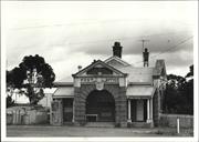
Constructed from 1912
The former Post Office contributes to the community's sense of history and place, as one of the earliest public buildings which until c.1992 was still used for its original purpose. The place is a fine example of Federation Arts and Crafts public architecture which is domestic in scale. The place contributes to the townscape and forms a vista at the end of Alton Street. The post office is a landmark building in its corner location and with its dominant roof form. The place has historic significance as part of a building boom that occurred around 1912, as Cuballing established itself as a progressive town with the facilities to support it.
The building is a single-storey structure in the Federation Arts & Craft style. The style was common for post office buildings throughout Western Australia built around the turn-of-the-century: by George Temple-Foole, Government Architect 1885-1896; Grainger, Temple-Pooie's successor( 1897-1905), and later, Hillson Beasley Government Architect 1906 - 1917. The building is located on the north-western corner of Campbell and Alton Streets, with the public entry off Campbell Street. The building shares the intersection with the former Western Australian Bank. This intersection with the two buildings are remnants that mark an oid commercial precinct of Cubailing. The building forms a vista at the end of Alton Street. The building is simpie in design and domestic in scale with richly modelled street elevations. The building is of traditional masonry and timber construction. The cgi clad roof forms a dominant element, with its medium pitch with a vented gablet, timber battened eaves, tail brick corbelled chimneys with potted tops and a metal roof vent. The main entry to the post office is via a well proportioned central portico. This portico dominates the front elevation in size and detail. The portico contains an elevated, recessed porch and has a large, three wide semicircular archways, the main archway has a pronounced key stone, flanked by two pilaster supported on a brick base. The pilasters are carried up in rendered brickwork and are capped with a stone frieze and triangular pediment featuring classical mouldings. The frieze bears the name of the building, 'Post Office'. The wide copings on the porticos are cement rendered. The brickwork is laid in stretcher bond with the exception of the top course which are headers. The brick voussoirs are highlighted with tuck-pointing. This portico is repeated on the Alton Street elevation. The recessed porch extends across the Campbell Street elevation and is covered, either side of the portico with lean-to roofs supported on Tuscan columns on small pedestals. The fenestration features casement sash windows with rendered decorative sills. The west elevation has double doors and windows with ripple iron hoods supported on timber framing. The windows are double-hung sashes with 6 panes in each sash. A residence is believed to have been added to the rear of the post office in the 1930s. The residence was built to match the post office and has a separate private entrance off Alton Street. The building has a hipped roof and French doors that open onto a verandah that extends down the Alton Street elevation. The interior of the post office comprises a single room with an exchange in one corner and a counter that separated public space from postal activities. The interior retains a match boarded ceiling, timber floors and skirtings, fireplace, original counter and post boxes. No physical evidence of the existence of the exchange remains. PLBs and a telephone booth were added to the Campbell Street elevation. The central window of the front elevation was altered to allow installation of the boxes. The telephone booth replaced a window opening, physical evidence of the opening remains. In 1994, the interior of the post office building was painted
Tenders for the construction of the Post Office were called on 8 February 1912.1 The tender of contractor A. R. Nelson was accepted on 22 April 1912, for the amount of £1,382/19/6.2 The progress of the construction of the Post Office can be followed through the region's newspaper, the Great Southern Leader. Unfortunately, there was no write-up about the opening of the Post Office. "Some indignation was expressed last week by local contractors because no plans or specifications of the new post office to be erected at Cuballing were obtainable locally".3 "Several new buildings are in the course of erection, and the new post office will soon be a reality. The contractor (Mr Nelson) is already at work, and has a number of men going."4 "The Hall and post office should soon be completed edifices. The 'pub' is also being pushed on..."5 "The New Post Office - Robbie is now ensconced in his new abode and right happy he looks. Reckons he can work all right now under good conditions".6 The post office ceased postal operations c.1992-7
INTEGRITY: High DEgree AUTHENTICITY: High Degree
Fair
| Ref ID No | Ref Name | Ref Source | Ref Date |
|---|---|---|---|
| "Great Southern Leader". p 3 | 8 March 1912, | ||
| Apperly, R., Irving, R., Reynolds, P; "A Pictorial Guide to Identifying Australian Architecture: Styles and Terms from 1788 to the Present". pp 140-143 | Angas & Robertson, Sydney, | 1994 | |
| Conversation with owner, | 30 January 1996. | ||
| 'Cuballing Heritage Trail' | |||
| "Government Gazette". p. 263. | 9 February 1912 | ||
| "Great Southern Leader". p 4 | 3 May 1912, | ||
| "Great Southern Leader". p 5 | 31 January 1913, | ||
| "Government Gazette". p 1570 | 26 April 1912, |
| Owner | Category |
|---|---|
| D Campbell | Other Private |
This information is provided voluntarily as a public service. The information provided is made available in good faith and is derived from sources believed to be reliable and accurate. However, the information is provided solely on the basis that readers will be responsible for making their own assessment of the matters discussed herein and are advised to verify all relevant representations, statements and information.

Lots 113&368 Campbell St Cuballing
CWA Hall, Shire Offices (fmr)
Road Board Office (fmr) & Agricultural Hall
Cuballing
Wheatbelt
Constructed from 1898 to 1980
| Type | Status | Date | Documents |
|---|---|---|---|
| State Register | Registered | 16 Dec 2003 | HCWebsite.Listing+ListingDocument, HCWebsite.Listing+ListingDocument |
| Type | Status | Date | Documents |
|---|---|---|---|
| (no listings) |
| Type | Status | Date | Grading/Management | |
|---|---|---|---|---|
| Category | ||||
| Municipal Inventory | Adopted | 30 Sep 1996 | 2 | |
| Name | Type | Year From | Year To |
|---|---|---|---|
| B H Dods, agric hall | Architect | - | - |
| Library Id | Title | Medium | Year Of Publication |
|---|---|---|---|
| 5927 | Images CD No. 10 : Station Master's House Wongan Hills; District Engineers House; Wongan Hills Railway Barracks & Cuballing Civic Group. | C D Rom | 2002 |
Individual Building or Group
| Epoch | General | Specific |
|---|---|---|
| Original Use | GOVERNMENTAL | Office or Administration Bldg |
| Original Use | SOCIAL\RECREATIONAL | Agricultural Hall |
| Other Use | GOVERNMENTAL | Town, Shire or District Hall |
| Present Use | SOCIAL\RECREATIONAL | CWA Hall |
| Style |
|---|
| Vernacular |
| Federation Free Classical |
| Type | General | Specific |
|---|---|---|
| Roof | METAL | Corrugated Iron |
| Wall | BRICK | Common Brick |
| Wall | STONE | Granite |
| General | Specific |
|---|---|
| SOCIAL & CIVIC ACTIVITIES | Community services & utilities |
| SOCIAL & CIVIC ACTIVITIES | Government & politics |
This information is provided voluntarily as a public service. The information provided is made available in good faith and is derived from sources believed to be reliable and accurate. However, the information is provided solely on the basis that readers will be responsible for making their own assessment of the matters discussed herein and are advised to verify all relevant representations, statements and information.
Constructed from 1912
The place has aesthetic value for its use of decorative structural elements and a facade treatment of strongly contrasting materials of painted and cement work that creates visual interest. These decorative elements are common features of the exuberance of the Federation Free style and as such the place makes a positive contribution to the streetscape. The place has landmark value on Campbell Street. The place has historic significance as part of a building boon? that occurred around 1912 as Cuballing established itself as a progressive town with the facilities to support it.
The building has a richly modelled classical facade with engaged brick piers on the side elevations. The exterior of the building is in red stretcher bond brickwork in local bricks. The front facade sits on a rendered brick plinth and has corner brick pilasters, and a rendered string course. The main feature of the front elevation is a rendered attenuated doorway surround with Art Nouveau detailing. The surround projects forward of the building face adding grandeur to the facade. The front etevation is symmetrical about a central doorway with a semi-circular arched window either side of the entrance. The windows have decorative rendered sills and surrounds with pronounced key stones. The windows are double-hung sashes divided into eight panes in the upper sash by slim glazing bars. The lower sashes are in an altered state. Some panes are extant. The entrance doorway has a glazed rectangular faniight divided ten panes by slim glazing bars. The pilasters extend to a rendered parapet that conceals a gable and hipped roof behind. The parapet frieze bears the name of the building, 'Cuballing Agricultural Hall'. The parapet is crowned in its centre by a dentil decorated semi-circular pediment with a circular accent containing a metal louvred vent. The east and west elevations (side elevations) have engaged piers that divide the elevations into three bays. The two rear bays each contain a window. The window treatment on the side elevations has been simplified to include a flat head. The rear elevation is strengthened by two stepped buttresses with a picture window high in the gable wall. Brick additions extend the east and west elevations. The original exterior walls, where the additions meet the original building, are evident in the interior with an original lintel of an old external opening. The additions are treated to match the original building. The gable ends extend to protect the casement windows, and are clad in fibro-cement lining as are the eaves soffit. The windows are simplified with simple rendered sills. Further brick additions are at the rear, with lean-to roofs. The additions accommodate toilets. The additions were built at different times as evidenced in the straight joint in the brickwork. The interior of the building comprises a central hall with a raised stage with timber stairs either side, and a kitchen with an old fireplace, behind the stage. The additions to the building have provided an activity area with a pool table, storage, new kitchen and servery and toilets. The interior of the original building has timber floorboards and rough rendered walls lined to resemble ashlar. Suspended fluorescent lights have been added and the entrance door has been replaced. A window on the east elevation has been bricked-up and replaced with a doorway. The interior of the additions to the building have linoleum covered floors, rendered walls and brick fireplaces.
The present Hall, built in 1912, designed by Mr Dods and opened by the Minister for Works, Mr W. D. Johnston in December 1912. The cost of the building was £890 of which £212 was provided by the Government. Local bricks from Davey Bros. Brickworks were used in the construction.1 The official opening of the Hall was reported in the local newspaper, the Great Southern Leader. The agricultural hall at Cuballing having become too small for the requirements of this growing district, it was decided some months ago to accept the offer of £250 made by the Road Board who wished to secure the building of an office. With this amount and the Government subsidy of £212 the committee instructed Mr. B. H. Dods to prepare plans for a larger and more up to date brick building on the adjoining block. The contract for the erection of the structure was secured by Mr. J. Brown, who has played such a prominent part in the building up of Narrogin and adjacent towns, and the result of the designer and artisan is a structure which is a credit to the district. To commemorate the opening of the hall the committee invited the Minister for Works (Mr. W. D. Johnson) and several other Parliamentarians...Mr Thos. Reynolds then welcomed the visitors, after which the Member for the District, on behalf of the residents asked the Minister for Works to lay the inaugural stone of the Cuballing Agricultural Hall... He [the Minister] then asked Mrs. Reynolds to open the hall, at the same time presenting her with a gold mounted silver key on behalf of the residents and expressing a wish that she would be long spared to continue the good work in Cuballing, of which there was such evidence of it in the past. In a few appropriate words Mrs. Reynolds declared the hall formerly open, which event was signalled by loud cheering.2 The construction of the Hall was part of a general development programme that was occurring in Cuballing at the time, as the following news excerpt illustrates: New building operations in the town are going on apace. A contract has been let for the building of the new Agricultural Hall, and this building, together with the new Post Office, and the spacious additions to the Hotel Cuballing, the handsome new Anglican Church just recently completed, and the spacious hall erected by Mr Reynolds, will give the town a decidedly more imposing appearance.
INTEGRITY: High Degree AUTHENTICITY: High Degree
Good
| Ref ID No | Ref Name | Ref Source | Ref Date |
|---|---|---|---|
| Apperly, R., Irving, R., Reynolds, P., A Pictorial Guide to Identifying Australian Architecture: Styles and Terms from 1788 to the Present". pp 136-139 | Angus & Robertson, Sydney, | 1994 | |
| Cuballing Heritage Trail' | Shire of Cuballing, | ||
| Shire of Cuballing information. | |||
| "Great Southern Leader,". p5 | 13 December 1912, |
| Owner | Category |
|---|---|
| Shire of Cuballing | Local Gov't |
This information is provided voluntarily as a public service. The information provided is made available in good faith and is derived from sources believed to be reliable and accurate. However, the information is provided solely on the basis that readers will be responsible for making their own assessment of the matters discussed herein and are advised to verify all relevant representations, statements and information.
Junct Hotham River & Commodine Creek Cuballing
Cuballing
Wheatbelt
| Type | Status | Date | Documents |
|---|---|---|---|
| (no listings) |
| Type | Status | Date | Documents |
|---|---|---|---|
| RHP - Does not warrant assessment | Current | 29 Nov 2019 |
| Type | Status | Date | Grading/Management | |
|---|---|---|---|---|
| Category | ||||
| Municipal Inventory | Adopted | 30 Sep 1996 | 4 | |
Historic site
| Epoch | General | Specific |
|---|---|---|
| Original Use | SOCIAL\RECREATIONAL | Other |
| Present Use | SOCIAL\RECREATIONAL | Other |
| General | Specific |
|---|---|
| SOCIAL & CIVIC ACTIVITIES | Sport, recreation & entertainment |
This information is provided voluntarily as a public service. The information provided is made available in good faith and is derived from sources believed to be reliable and accurate. However, the information is provided solely on the basis that readers will be responsible for making their own assessment of the matters discussed herein and are advised to verify all relevant representations, statements and information.
Public Nomination - no information supplied and significance not established.
Site Only
| Owner | Category |
|---|---|
| Shire of Cuballing | Local Gov't |
This information is provided voluntarily as a public service. The information provided is made available in good faith and is derived from sources believed to be reliable and accurate. However, the information is provided solely on the basis that readers will be responsible for making their own assessment of the matters discussed herein and are advised to verify all relevant representations, statements and information.
6 Morrell St Cuballing
Cuballing
Wheatbelt
Constructed from 1914
| Type | Status | Date | Documents |
|---|---|---|---|
| (no listings) |
| Type | Status | Date | Documents |
|---|---|---|---|
| (no listings) |
| Type | Status | Date | Grading/Management | |
|---|---|---|---|---|
| Category | ||||
| Municipal Inventory | Adopted | 30 Sep 1996 | 3 | |
Individual Building or Group
| Epoch | General | Specific |
|---|---|---|
| Present Use | RESIDENTIAL | Single storey residence |
| Original Use | RESIDENTIAL | Single storey residence |
| Type | General | Specific |
|---|---|---|
| Roof | METAL | Corrugated Iron |
| Wall | STONE | Other Stone |
| General | Specific |
|---|---|
| DEMOGRAPHIC SETTLEMENT & MOBILITY | Settlements |
This information is provided voluntarily as a public service. The information provided is made available in good faith and is derived from sources believed to be reliable and accurate. However, the information is provided solely on the basis that readers will be responsible for making their own assessment of the matters discussed herein and are advised to verify all relevant representations, statements and information.
Constructed from 1914
The place is considered to have some significance: to be retained and conserved if possible, and the conservation of the significance of the place should be encouraged through provisions of the town planning scheme. It is recommended that prior to any major changes to the place, or demolition, that a photographic record be taken of the place.
'Ingersley* is set in a lawned setting well back from the street alignment. The building is constructed of stone with brick quoins to openings. The roof is a dominant feature of the building and has vented gablets, gable finial and a tall corbelled brick chimney. The roof extends to cover an encircling concrete verandah which is supported on square timber posts. The main feature of the exterior of the building is a flattened brick arch in a concrete base that stands alone in front of the entry of the front elevation. The arch bears the name of the building. The interior of the building comprises four rooms, two either side of a central passage. A living space and bedroom occupy the two front rooms with two bedrooms behind. The interior has pressed metal ceilings and one ceiling rose remains. A stone extension has been added to the west elevation to accommodate bathroom facilities, and a timber framed, fibro-cement clad addition extends across the rear elevation accommodating a kitchen. The exterior walls were rendered to window sill height by the Shire of Cuballing, possibly as an attempt to arrest rising damp.
Built in c.1914 and now owned by the Shire.
INTEGRITY: High Degree AUTHENTICITY: High Degree
| Ref ID No | Ref Name | Ref Source | Ref Date |
|---|---|---|---|
| "Cuballing Heritage Trail". | Shire of Cuballing |
| Owner | Category |
|---|---|
| Shire of Cuballing | Local Gov't |
This information is provided voluntarily as a public service. The information provided is made available in good faith and is derived from sources believed to be reliable and accurate. However, the information is provided solely on the basis that readers will be responsible for making their own assessment of the matters discussed herein and are advised to verify all relevant representations, statements and information.
Lot 300 Ridley St Cuballing
Cuballing
Wheatbelt
Constructed from 1905
| Type | Status | Date | Documents |
|---|---|---|---|
| (no listings) |
| Type | Status | Date | Documents |
|---|---|---|---|
| (no listings) |
| Type | Status | Date | Grading/Management | |
|---|---|---|---|---|
| Category | ||||
| Municipal Inventory | Adopted | 30 Sep 1996 | 5 | |
Individual Building or Group
| Epoch | General | Specific |
|---|---|---|
| Original Use | RESIDENTIAL | Single storey residence |
| Present Use | RESIDENTIAL | Single storey residence |
| Style |
|---|
| Vernacular |
| Type | General | Specific |
|---|---|---|
| Roof | METAL | Corrugated Iron |
| Wall | TIMBER | Weatherboard |
| General | Specific |
|---|---|
| TRANSPORT & COMMUNICATIONS | Rail & light rail transport |
This information is provided voluntarily as a public service. The information provided is made available in good faith and is derived from sources believed to be reliable and accurate. However, the information is provided solely on the basis that readers will be responsible for making their own assessment of the matters discussed herein and are advised to verify all relevant representations, statements and information.
Constructed from 1905
The building is a representative example of a simple weatherboard clad cottage built at the turn-of-the-century. The Railway House, as the only remaining component of the railway station precinct, has historic value for its important associations with the development of the State's railway system and the vital role it played in the settlement and development of Cuballing.
The railway station and platform are no longer extant. The building has twin gabled roofs spanning the length of the building. The residence addresses the railway line. The front elevation (west) of the building is symmetrical about a central doorway with a doubie-hung sash window either side. A timber verandah stretches across the front elevation. The main roor extends to cover the verandah and is supported on square timber posts. The side elevations feature small metal awnings protecting wail vents. The south elevation has an external brick chimney breast and metal chimney. The interior is unembeliished and has linings in timber boards. The kitchen has been upgraded, now lined with plasterboard, and the toilet added. The original outdoor WC is no longer extant. The interior now comprises two bedrooms, laundry, kitchen and bathroom. Lean-to roofs cover a rear addition and additions to both north and south elevations. The construction of the additions match the original building.
The railway house was built to accommodate the station master.' The place was occupied by a railway worker about 47 years ago soon after the last station master was relocated to Perth. The Railway House is featured on a progress plan for the Cuballing Railway Station, prepared in 1905.
INTEGRITY: High Degree AUTHENTICITY: Moderate Degree
Fair
| Ref ID No | Ref Name | Ref Source | Ref Date |
|---|---|---|---|
| WAG Railway, 'Progress Plan - Cuballing [Public Records Office, AN 262/12, ACC1642, Plan No. 254 (1904-49) CCE 76659]. | |||
| Conversation with Mr R. Maralee, | 23 April 1996. |
| Owner | Category |
|---|---|
| Mr Ronald Maraiee | Other Private |
This information is provided voluntarily as a public service. The information provided is made available in good faith and is derived from sources believed to be reliable and accurate. However, the information is provided solely on the basis that readers will be responsible for making their own assessment of the matters discussed herein and are advised to verify all relevant representations, statements and information.
Springhill Rd Cuballing
Reserve 8405
Cuballing
Wheatbelt
| Type | Status | Date | Documents |
|---|---|---|---|
| (no listings) |
| Type | Status | Date | Documents |
|---|---|---|---|
| (no listings) |
| Type | Status | Date | Grading/Management | |
|---|---|---|---|---|
| Category | ||||
| Municipal Inventory | Adopted | 30 Sep 1996 | 5 | |
Historic site
| Epoch | General | Specific |
|---|---|---|
| Original Use | MONUMENT\CEMETERY | Cemetery |
| Present Use | MONUMENT\CEMETERY | Cemetery |
| General | Specific |
|---|---|
| DEMOGRAPHIC SETTLEMENT & MOBILITY | Settlements |
This information is provided voluntarily as a public service. The information provided is made available in good faith and is derived from sources believed to be reliable and accurate. However, the information is provided solely on the basis that readers will be responsible for making their own assessment of the matters discussed herein and are advised to verify all relevant representations, statements and information.
The cemetery is an important site for the Cuballing community providing a link with past citizens.
The cemetery is located toward the western outskirts of the tcwnsite of Cuballing.
Reserve No. 8405 was gazetted for the purpose of a cemetery on 20 March 1903.1 The date of the first headstone is 20 December 190S.2
INTEGRITY: High Degree AUTHENTICITY: High Degree
| Ref ID No | Ref Name | Ref Source | Ref Date |
|---|---|---|---|
| "Cemeteries Index". | Battye Library | ||
| "Government Gazette". p 674 | 20 March 1903, |
| Owner | Category |
|---|---|
| Shire of Cuballing | Local Gov't |
This information is provided voluntarily as a public service. The information provided is made available in good faith and is derived from sources believed to be reliable and accurate. However, the information is provided solely on the basis that readers will be responsible for making their own assessment of the matters discussed herein and are advised to verify all relevant representations, statements and information.
Junct to Cuballing, Wickepin & Yealering East Cuballing
on Stock route
Cuballing
Wheatbelt
| Type | Status | Date | Documents |
|---|---|---|---|
| (no listings) |
| Type | Status | Date | Documents |
|---|---|---|---|
| RHP - Does not warrant assessment | Current | 16 Sep 2020 |
| Type | Status | Date | Grading/Management | |
|---|---|---|---|---|
| Category | ||||
| Municipal Inventory | Adopted | 30 Sep 1996 | 4 | |
Tree
| Epoch | General | Specific |
|---|---|---|
| Present Use | Transport\Communications | Road: Other |
| Original Use | Transport\Communications | Road: Other |
| Type | General | Specific |
|---|---|---|
| Other | TIMBER | Other Timber |
| General | Specific |
|---|---|
| TRANSPORT & COMMUNICATIONS | Mail services |
This information is provided voluntarily as a public service. The information provided is made available in good faith and is derived from sources believed to be reliable and accurate. However, the information is provided solely on the basis that readers will be responsible for making their own assessment of the matters discussed herein and are advised to verify all relevant representations, statements and information.
The Tree has historic value as a reminder of the community's efforts to communicate when mail services were limited.
The tree is a substantial White Gum that is beside the road amongst bushiand. The tree is located on a frequented stock route. The nail Is extant.
A nail in the tree was used for securing community notices.
INTEGRITY: High Degree AUTHENTICITY: High Degree
Good
This information is provided voluntarily as a public service. The information provided is made available in good faith and is derived from sources believed to be reliable and accurate. However, the information is provided solely on the basis that readers will be responsible for making their own assessment of the matters discussed herein and are advised to verify all relevant representations, statements and information.
1380 Neamutin Rd East Popanyinning
Cuballing
Wheatbelt
Constructed from 1907
| Type | Status | Date | Documents |
|---|---|---|---|
| (no listings) |
| Type | Status | Date | Documents |
|---|---|---|---|
| (no listings) |
| Type | Status | Date | Grading/Management | |
|---|---|---|---|---|
| Category | ||||
| Municipal Inventory | Adopted | 30 Sep 1996 | 3 | |
Individual Building or Group
| Epoch | General | Specific |
|---|---|---|
| Present Use | FARMING\PASTORAL | Silo or Grain Shed |
| Other Use | FARMING\PASTORAL | Stable |
| Original Use | FARMING\PASTORAL | Shed or Barn |
| Type | General | Specific |
|---|---|---|
| Roof | METAL | Corrugated Iron |
| Wall | STONE | Other Stone |
| General | Specific |
|---|---|
| OCCUPATIONS | Grazing, pastoralism & dairying |
This information is provided voluntarily as a public service. The information provided is made available in good faith and is derived from sources believed to be reliable and accurate. However, the information is provided solely on the basis that readers will be responsible for making their own assessment of the matters discussed herein and are advised to verify all relevant representations, statements and information.
Constructed from 1907
The barn is typical of outbuildings associated with farming properties in the State. It is indicative of a way of life prior to the common use of motorised transport.
The building is constructed of coursed random rubble stone walls. The building has timber floors, and a shingie rcof construction which was replaced with cgi in 1950.
The barn was originally used as stables, chaff house and storage for the Nyamutin farm. The barn was often used as a meeting place for people in the district, with dances being held regularly.
INTEGRITY: High Degree AUTHENTICITY: High Degree
Good
| Owner | Category |
|---|---|
| B. J. & S. McBurney | Other Private |
This information is provided voluntarily as a public service. The information provided is made available in good faith and is derived from sources believed to be reliable and accurate. However, the information is provided solely on the basis that readers will be responsible for making their own assessment of the matters discussed herein and are advised to verify all relevant representations, statements and information.

S side Yealering-Popanyinning Rd,1k E Nyamutin Gully Nyamutin
Cuballing
Wheatbelt
Constructed from 1914
| Type | Status | Date | Documents |
|---|---|---|---|
| (no listings) |
| Type | Status | Date | Documents |
|---|---|---|---|
| (no listings) |
| Type | Status | Date | Grading/Management | |
|---|---|---|---|---|
| Category | ||||
| (no listings) | ||||
Individual Building or Group
| Epoch | General | Specific |
|---|---|---|
| Original Use | RELIGIOUS | Church, Cathedral or Chapel |
| Present Use | RELIGIOUS | Church, Cathedral or Chapel |
This information is provided voluntarily as a public service. The information provided is made available in good faith and is derived from sources believed to be reliable and accurate. However, the information is provided solely on the basis that readers will be responsible for making their own assessment of the matters discussed herein and are advised to verify all relevant representations, statements and information.